WKN Weer, Klimaat en Natuurrampen
Lees alles over het onstuimige weer op onze planeet, volg orkanen en tornado's, zie hoe vulkanen uitbarsten en hoe Moeder Aarde beeft bij een aardbeving. Alles over de verwoestende kracht van onze planeet en tal van andere natuurverschijnselen.


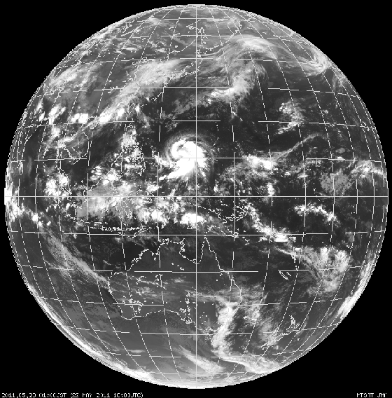
Tropical Storm Eyes Philippines and Japan
"The storm... should be able to strengthen into a typhoon."
Newly formed Tropical Storm 04W may pose threats for both the northern Philippines and eventually Japan.
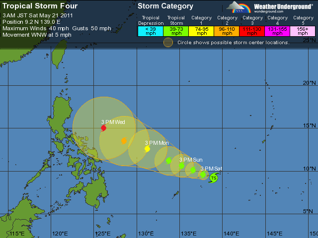
As of Friday morning, EDT, the center of Tropical Storm 04W (which had yet to be given a name) was located approximately 200 miles east-southeast of the small island of Yap.
Due to light winds aloft, this storm will move very slowly over the next several days. The center of the storm will pass over or very close to Yap Sunday, EDT.
Early next week, the storm will be over the warm waters of the Philippine Sea, and should be able to strengthen into a typhoon.
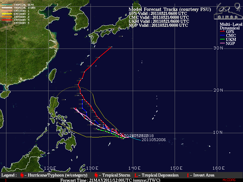
The future track of the storm remains quite uncertain through the middle to end of next week. An upper-air trough of low pressure will dive southeastward over southeastern China. This upper-air trough will eventually steer the storm to the northeast.
If the trough moves in fast enough, the storm could be steered on a path that puts both the Philippines and eventually Japan out of harm's way.
However, if this trough is slower to dive southeastward, the storm may pass close to the northern Philippines, and possibly get steered close enough to Japan to affect that country.
Any effect on the Philippines would not occur until the middle of next week at the earliest, with any possible effects on Japan occurring late in the week.
Accuweather
"The storm... should be able to strengthen into a typhoon."

Newly formed Tropical Storm 04W may pose threats for both the northern Philippines and eventually Japan.
As of Friday morning, EDT, the center of Tropical Storm 04W (which had yet to be given a name) was located approximately 200 miles east-southeast of the small island of Yap.
Due to light winds aloft, this storm will move very slowly over the next several days. The center of the storm will pass over or very close to Yap Sunday, EDT.
Early next week, the storm will be over the warm waters of the Philippine Sea, and should be able to strengthen into a typhoon.
The future track of the storm remains quite uncertain through the middle to end of next week. An upper-air trough of low pressure will dive southeastward over southeastern China. This upper-air trough will eventually steer the storm to the northeast.
If the trough moves in fast enough, the storm could be steered on a path that puts both the Philippines and eventually Japan out of harm's way.
However, if this trough is slower to dive southeastward, the storm may pass close to the northern Philippines, and possibly get steered close enough to Japan to affect that country.
Any effect on the Philippines would not occur until the middle of next week at the earliest, with any possible effects on Japan occurring late in the week.
Accuweather
Volgens GFS wordt het geen landfall op de Filipijnen, maar buigt de orkaan net voor het eiland af. Wat niet wil zeggen dat ze daar er niets van gaan merken. De neerslag e.d. kan eventueel nog voor overlast gaan zorgen.
Onderstaand kaartje is voor donderdag, dus voor hetzelfde krijgt de Filipijnen wel een voltreffer.
Onderstaand kaartje is voor donderdag, dus voor hetzelfde krijgt de Filipijnen wel een voltreffer.
Wundergroundquote:First typhoon of 2011 coming?
In the Northwest Pacific, Tropical Storm Four has formed, and appears poised to become the first typhoon of 2011 by early next week. The storm is expected to head west-northwest or northwest towards the Philippines. While the GFS model predicts Tropical Storm Four will miss the Philippines and recurve northwards towards Japan late next week, it is too early to be confident of this forecast.
De typhoon lijkt voor de Filipijnen af te buigen richting Japan. Ik denk dat Japan geen rekening hoeft te houden met een orkaan (watertemperatuur ligt rond de 20 graden). Maar het restant kan nog wel voor de nodige overlast gaan zorgen.
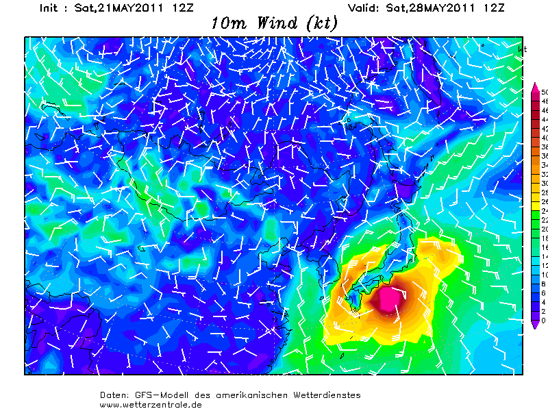
GFS kaart van zaterdag 28 mei.
De orkaan ligt dan dicht bij Japan
[ Bericht 10% gewijzigd door #ANONIEM op 21-05-2011 19:37:35 ]
GFS kaart van zaterdag 28 mei.
De orkaan ligt dan dicht bij Japan
[ Bericht 10% gewijzigd door #ANONIEM op 21-05-2011 19:37:35 ]

Inderdaad ja. Dat is ook 120 uur verder, dus kan nog veel veranderen. Hoogste windsnelheid wordt geschat op 212 km/uur (categorie4). De watertemperatuur is rond de 30 graden in dit gebied.quote:Op zaterdag 21 mei 2011 23:19 schreef Frutsel het volgende:
Lijkt er op dat ie toch dichter bij de kust komt dan eerst?
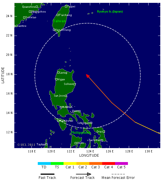
Volgens GFS trekt ie naar het noorden van de Filipijnen en is daarna Taiwan aan de beurt.quote:
inmiddels hernoemd naar Songda
Draait hij nu nog verder weg of krijgt Taiwan de volle laag?
Maar is nog ver weg.

dat kunnen ze nog wel hebben daar, een orkaantje...
Inorbit: zeg dat dan typluie triangeljosti
Beauregard: Een beetje FOK!ker laat het brood door z'n moeder smeren.
Ecosia
ek's 'n flash drive, jy's 'n floppy
Beauregard: Een beetje FOK!ker laat het brood door z'n moeder smeren.
Ecosia
ek's 'n flash drive, jy's 'n floppy
Japan bedoel je?quote:
dat kunnen ze nog wel hebben daar, een orkaantje...
Volgens de kaarten krijgt Japan ook te maken met deze orkaan. Zeewatertemperatuur is daar rond de 20 graden en dat is te koud voor een tropische orkaan. Japan krijgt wel te maken met storm en neerslag.
Ook in de Oost Pacific is nu een Invest. 10% kans...
Invest in de Atlantische Oceaan heeft 20% kans...
Invest in de Atlantische Oceaan heeft 20% kans...
Kans bestaat dat er zich tussen Jamaica en Centraal Amerika een tropische storing ontwikkeld ergens tussen 31 mei en 2 juni.
Wundergroundquote:an early start to hurricane season?
The Atlantic hurricane season officially begin on Wednesday, June 1, and recent computer model runs predict that we may have some early-season action in the Central Caribbean Sea to coincide with the start of this year's season. The GFS, NOGAPS, and ECMWF models have all indicated in some of their recent runs that a tropical disturbance may form between Jamaica and Central America sometime in the May 31 - June 2 time frame, as a lobe of the Eastern Pacific Intertropical Convergence Zone (ITCZ) pushes across Central America into the Caribbean. Up until now, wind shear has been too high to allow tropical storm formation in the Caribbean, due to the presence of the Subtropical Jet Stream. However, this jet is expected to push northwards over Cuba over the coming week, allowing a region of low wind shear to develop over most of the Caribbean. Water temperatures in the Central Caribbean are about 1°C above average, 29°C, which is plenty warm enough to support development of a tropical storm. The main impediment to development will probably be lack of spin, as we don't have any African tropical waves that are expected to enter the Caribbean Sea next week, to help get things spinning. Stay tuned.
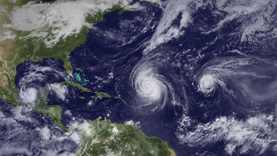
Na tornado's buitengewoon zwaar orkaanseizoen in VS
Na het meest dodelijke tornadoseizoen in zestig jaar krijgen de Verenigde Staten te maken met nog meer natuurgeweld. De Amerikaanse meteorologische dienst waarschuwt voor een "buitengewoon orkaanseizoen".
Elk jaar doet de National Oceanic and Atmospheric Administration (NOAA) voorspellingen over het orkaanseizoen, dat in juni begint. Dit jaar zijn die vooruitzichten zorgwekkend. De dienst verwacht drie tot zes grote orkanen van categorie 3, 4 of 5, met windsnelheden van 180 kilometer per uur of meer.
Ook vorig jaar waarschuwde de NOAA voor orkaangeweld, maar toen kwamen de VS goed weg. "De Verenigde Staten hadden geluk", zegt Jane Lubchenco van de NOAA. "Winden duwden de meeste tropische stormen en orkanen weg van onze kust. Maar we kunnen niet op geluk blijven rekenen. We moeten voorbereid zijn, en zeker na deze voorspellingen."
Waarschuwing
De NOAA wijt de hogere kans op orkanen onder meer aan het warmere water in de Atlantische Oceaan en aan de naweeën van het klimaatfenomeen La Niña.
"De tornado's die het zuiden van het land getroffen hebben en de vele overstromingen die we deze lente gezien hebben, moeten een waarschuwing zijn dat rampen overal en op elk moment kunnen toeslaan", zegt Craig Fugate van het Amerikaans Bureau voor Rampenbestrijding. Hij drukt de inwoners van de risicogebieden op het hart om zich goed voor te bereiden en noodscenario's voor hun gezin klaar te hebben. (ips/gb)
hln
Als dat zo is zijn wij ook het bokje qua zomer 
Als die systemen onze kant op komen dan hoef ik dit jaar geen zwembad te gaan halen...
Natuurlijk kan zulke systemen voor mooi weer zorgen maar voor nu heb ik mijn twijfels hieraan..
Anyway we gaan het allemaal op de voet volgen
Als die systemen onze kant op komen dan hoef ik dit jaar geen zwembad te gaan halen...
Natuurlijk kan zulke systemen voor mooi weer zorgen maar voor nu heb ik mijn twijfels hieraan..
Anyway we gaan het allemaal op de voet volgen
Doe mee met het voorspellen van het weer!
Weekvoorspelling | Week 12 (invullen tot 16-03 - 11:59)
Maandvoorspelling Maart (Inzendingen gesloten)
Jaarvoorspelling 2025 / 2026
Weekvoorspelling | Week 12 (invullen tot 16-03 - 11:59)
Maandvoorspelling Maart (Inzendingen gesloten)
Jaarvoorspelling 2025 / 2026
Er lijkt zich inderdaad iets te ontwikkelen in de Caribische zee. In eerste instantie lijkt het niet veel voor te stellen, maar het kan een vroege start worden.

Meestal duurt het dan nog een aantal weken voordat de eerste serieuze storm ontstaat.quote:
 Op
Op Kans is nog steeds aanwezig dat het gebiedje in de Caribische zee iets gaat worden.
Vandaag is officieel het orkaan seizoen in de Atlantische Oceaan van start gegaan. Meestal duurt het dan nog wel een tijdje voor de eerste serieuse storm onstaat. Momenteel is er een invest ten oosten van Florida dat in de gaten gehouden wordt. Het systeem heeft nu 30% kans op een ontwikkeling tot een tropische storm en dat is erg weinig.
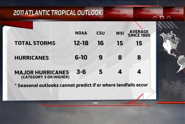
Accuweather heeft ook een voorspelling uitgebracht. Men voorspelt 15 tropische stormen die een naam krijgen. Hiervan gaan er 8 de orkaan status halen en 4 zullen de status krijgen van 'Major Hurricane' (cat 3 of meer).
Verder verwacht men meer impact op het vaste land dan vorig jaar.
Al een aantal dagen lijkt het erop dat er een storing gaat ontstaan in de Caribische zee. Het is afwachten wat dit gaat worden. Al groeit dit systeem niet uit tot een tropische depressie of meer, het kan nog wel voor de nodige hoeveelheden regen zorgen.
Accuweather heeft ook een voorspelling uitgebracht. Men voorspelt 15 tropische stormen die een naam krijgen. Hiervan gaan er 8 de orkaan status halen en 4 zullen de status krijgen van 'Major Hurricane' (cat 3 of meer).
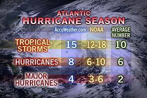
Verder verwacht men meer impact op het vaste land dan vorig jaar.
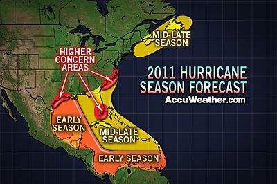
Al een aantal dagen lijkt het erop dat er een storing gaat ontstaan in de Caribische zee. Het is afwachten wat dit gaat worden. Al groeit dit systeem niet uit tot een tropische depressie of meer, het kan nog wel voor de nodige hoeveelheden regen zorgen.
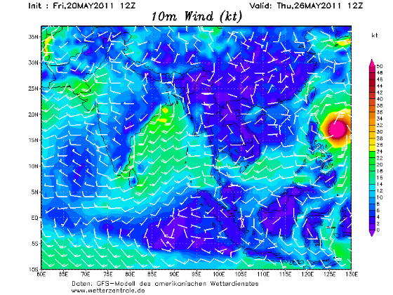
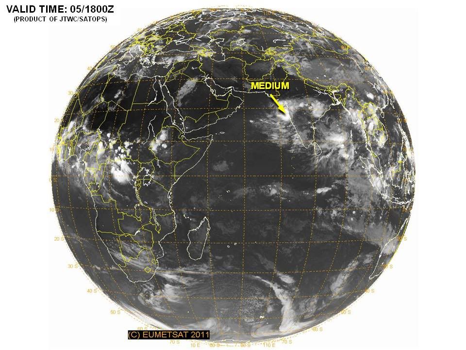
Er is nu ook een invest in de Arabische Zee (zee tussen Jemen, Oman, Pakistan Iran Verenigde Arabische Emiraten en India.).
Volgens de kaarten van GFS gaat dit systeem zich langzaam ontwikkelen en kan in eerste instantie voor overlast gaan zorgen langs de westkust van India.
Dit systeem lijkt momenteel de meeste kans te hebben om uit te gaan groeien tot een flinke storm.
Orkanen komen hier niet veel voor, het gemiddelde staat op 1 per jaar.
Verwachting orkaanseizoen 2011
Elk jaar wordt er aan het eind van de lente een verwachting opgesteld voor het komende orkaanseizoen in het Caribisch gebied en het tropische deel van de Atlantische Oceaan. Vorig jaar werd een zwaar orkaanseizoen verwacht en uiteindelijk werden 19 tropische stormen geteld. We moeten terug naar 2005 voor een nog zwaarder seizoen. Dat was overigens het jaar dat Katrina de Amerikaanse stad New Orleans trof. Inmiddels zijn de verwachtingen voor 2011 uitgegeven en vandaag behandelen we er drie. We bekijken de vooruitblik van de NOAA, WCS en de Britse weerdienst.
Afwijking in zeewatertemperatuur tussen vorig jaar en dit jaar. Het zeewater is iets minder warm waardoor tropische storingen niet zo snel tot ontwikkeling kunnen komen zoals vorig jaar het geval was. (Bron: WCS)
NOAA
De NOAA is de nationale weerdienst in Amerika en maakt elk jaar seizoensverwachtingen. In de zomerverwachting wordt ook altijd gekeken naar het komende orkaanseizoen. De NOAA verwacht een bovennormaal seizoen met 12 tot 18 tropische stormen waarvan 6 tot 10 zullen uitgroeien tot een orkaan. 3 tot 6 van deze orkanen kunnen uitgroeien tot een categorie 3, 4 of 5 orkaan. Wanneer en waar ze zullen toeslaan, is moeilijk aan te geven. Dat is bij orkanen pas op het laatste moment duidelijk. Feit is wel dat vorig jaar de Amerikaanse oostkust geluk gehad heeft. De meeste tropische stormen (in totaal ontstonden er 19) bleven op volle zee en slechts 1 orkaan (Bonnie) maakte landfall langs de oostkust. Of de orkanen dit jaar ook op ruime afstand van de kust blijven, moet nog maar blijken. Ondanks dat er iets minder stormen worden verwacht, gaat men er vanuit dat de impact voor de Amerikaanse oostkust dit jaar groter zal zijn.
Sinds 1995 zitten we in een regelmatig terugkerende situatie waarbij hogere watertemperaturen en een bepaald stromingspatroon boven het tropische deel van de Atlantische Oceaan het ontstaan van tropische stormen “makkelijker” maken. Deze cyclus duurt een aantal jaren, maar we zitten er nu dus nog middenin. Daarnaast zien we nu dat de watertemperaturen ongeveer 1 graad warmer zijn dan normaal in deze tijd van het jaar. Tenslotte is La Niña vrijwel voorbij, maar in de hogere luchtlagen is de komende tijd nog een afname van de windschering (verandering in windsterkte en – richting met de hoogte) zichtbaar zodat tropische stormen makkelijker kunnen ontstaan.
De "Tropical Cyclone Heat Potential (TCHP) op 30 april 2011 (boven) en 2010 (onder). Op basis van deze waarden verwacht WCS dat er iets minder tropische stormen ontstaan in vergelijking tot vorig jaar. Overigens kan het zijn dat de watertemperatuur de komende weken verder oploopt dan dat men nu verwacht. In dat geval kan het aantal stormen ook hoger uitkomen. (Bron: WCS)
WCS
De World Climate Service (onderdeel van de Meteo Group) verwacht ook een actief seizoen, maar niet zo actief als vorig jaar. Men verwacht 13 tot 17 tropische stormen waarvan 6 tot 9 zullen uitgroeien tot een orkaan en 3 of 4 zelfs een orkaan van de zwaardere categorie worden.
Als belangrijkste reden geeft WCS aan dat de zeewatertemperatuur hoger is dan normaal. Toch hebben recente studies aangetoond dat het niet voldoende is om enkel naar de temperatuur van het zeewateroppervlak te kijken. Een dunne laag met warm zeewater kan bij menging door wind of stroming weer heel snel afkoelen. Belangrijker is om te kijken naar de aanwezige warmte-energie in een dikkere kolom oceaanwater. De “Tropical Cyclone Heat Potential” (TCHP) was eind april in een groot deel van het Caribisch gebied (sterk) positief terwijl dat een jaar eerder niet het geval was.
Op 16 september 2010 waren er drie orkanen actief boven de Atlantische Oceaan en de Caribische zee. Het ging om Karl, Igor en Julia. (Bron: NOAA)
UKMO
De Britse weerdienst, The UK Met Office maakt sinds een paar jaar ook verwachtingen. Dat is niet omdat de restanten van tropische stormen uiteindelijk ook in Europa voor onstuimig weer kunnen zorgen, maar vanwege het simpele feit dat orkanen in de VS grote invloed hebben in de hele wereld. Denk daarbij aan de wereldvoedselmarkt en de soms snelle veranderingen in olieprijzen.
De UKMO verwacht ongeveer 13 tropische stormen met een 70% kans dat het aantal tussen 10 en 17 komt te liggen. Daarmee is de UKMO iets minder scheutig in vergelijking tot de verwachting van de NOAA en WCS. De UKMO kijkt niet alleen naar het aantal stormen, men probeert ook een beeld te krijgen van de levensduur en intensiteit van de stormen. Voor dit jaar verwacht men een Accumulated Cyclone Energy index (ACE) van 151 met een 70% kans dat de index tussen 89 tot 212 komt te liggen. Dit is ver boven het gemiddelde van 104 (gebasseerd op de periode 1980-2010).
Hoeveel tropische stormen, orkanen en zware orkanen er dit jaar uiteindelijk in de boeken worden bijgeschreven weten we pas eind november. Op dat moment is het seizoen van 2011 afgelopen al hebben we in 2005 gezien dat zelfs in december nog enkele stormen tot ontwikkeling kwamen.
Bron: Meteo Consult, NOAA, WorldClimateService, UKMO
Elk jaar wordt er aan het eind van de lente een verwachting opgesteld voor het komende orkaanseizoen in het Caribisch gebied en het tropische deel van de Atlantische Oceaan. Vorig jaar werd een zwaar orkaanseizoen verwacht en uiteindelijk werden 19 tropische stormen geteld. We moeten terug naar 2005 voor een nog zwaarder seizoen. Dat was overigens het jaar dat Katrina de Amerikaanse stad New Orleans trof. Inmiddels zijn de verwachtingen voor 2011 uitgegeven en vandaag behandelen we er drie. We bekijken de vooruitblik van de NOAA, WCS en de Britse weerdienst.
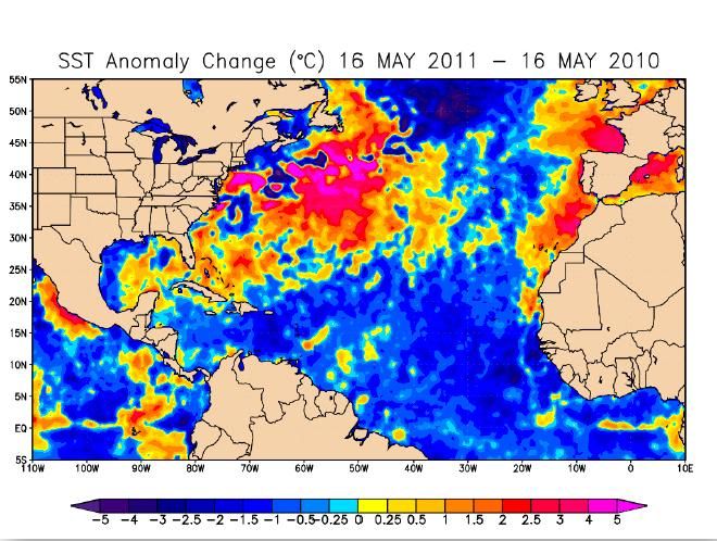
Afwijking in zeewatertemperatuur tussen vorig jaar en dit jaar. Het zeewater is iets minder warm waardoor tropische storingen niet zo snel tot ontwikkeling kunnen komen zoals vorig jaar het geval was. (Bron: WCS)
NOAA
De NOAA is de nationale weerdienst in Amerika en maakt elk jaar seizoensverwachtingen. In de zomerverwachting wordt ook altijd gekeken naar het komende orkaanseizoen. De NOAA verwacht een bovennormaal seizoen met 12 tot 18 tropische stormen waarvan 6 tot 10 zullen uitgroeien tot een orkaan. 3 tot 6 van deze orkanen kunnen uitgroeien tot een categorie 3, 4 of 5 orkaan. Wanneer en waar ze zullen toeslaan, is moeilijk aan te geven. Dat is bij orkanen pas op het laatste moment duidelijk. Feit is wel dat vorig jaar de Amerikaanse oostkust geluk gehad heeft. De meeste tropische stormen (in totaal ontstonden er 19) bleven op volle zee en slechts 1 orkaan (Bonnie) maakte landfall langs de oostkust. Of de orkanen dit jaar ook op ruime afstand van de kust blijven, moet nog maar blijken. Ondanks dat er iets minder stormen worden verwacht, gaat men er vanuit dat de impact voor de Amerikaanse oostkust dit jaar groter zal zijn.
Sinds 1995 zitten we in een regelmatig terugkerende situatie waarbij hogere watertemperaturen en een bepaald stromingspatroon boven het tropische deel van de Atlantische Oceaan het ontstaan van tropische stormen “makkelijker” maken. Deze cyclus duurt een aantal jaren, maar we zitten er nu dus nog middenin. Daarnaast zien we nu dat de watertemperaturen ongeveer 1 graad warmer zijn dan normaal in deze tijd van het jaar. Tenslotte is La Niña vrijwel voorbij, maar in de hogere luchtlagen is de komende tijd nog een afname van de windschering (verandering in windsterkte en – richting met de hoogte) zichtbaar zodat tropische stormen makkelijker kunnen ontstaan.
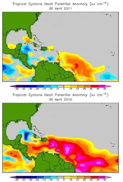
De "Tropical Cyclone Heat Potential (TCHP) op 30 april 2011 (boven) en 2010 (onder). Op basis van deze waarden verwacht WCS dat er iets minder tropische stormen ontstaan in vergelijking tot vorig jaar. Overigens kan het zijn dat de watertemperatuur de komende weken verder oploopt dan dat men nu verwacht. In dat geval kan het aantal stormen ook hoger uitkomen. (Bron: WCS)
WCS
De World Climate Service (onderdeel van de Meteo Group) verwacht ook een actief seizoen, maar niet zo actief als vorig jaar. Men verwacht 13 tot 17 tropische stormen waarvan 6 tot 9 zullen uitgroeien tot een orkaan en 3 of 4 zelfs een orkaan van de zwaardere categorie worden.
Als belangrijkste reden geeft WCS aan dat de zeewatertemperatuur hoger is dan normaal. Toch hebben recente studies aangetoond dat het niet voldoende is om enkel naar de temperatuur van het zeewateroppervlak te kijken. Een dunne laag met warm zeewater kan bij menging door wind of stroming weer heel snel afkoelen. Belangrijker is om te kijken naar de aanwezige warmte-energie in een dikkere kolom oceaanwater. De “Tropical Cyclone Heat Potential” (TCHP) was eind april in een groot deel van het Caribisch gebied (sterk) positief terwijl dat een jaar eerder niet het geval was.
Op 16 september 2010 waren er drie orkanen actief boven de Atlantische Oceaan en de Caribische zee. Het ging om Karl, Igor en Julia. (Bron: NOAA)
UKMO
De Britse weerdienst, The UK Met Office maakt sinds een paar jaar ook verwachtingen. Dat is niet omdat de restanten van tropische stormen uiteindelijk ook in Europa voor onstuimig weer kunnen zorgen, maar vanwege het simpele feit dat orkanen in de VS grote invloed hebben in de hele wereld. Denk daarbij aan de wereldvoedselmarkt en de soms snelle veranderingen in olieprijzen.
De UKMO verwacht ongeveer 13 tropische stormen met een 70% kans dat het aantal tussen 10 en 17 komt te liggen. Daarmee is de UKMO iets minder scheutig in vergelijking tot de verwachting van de NOAA en WCS. De UKMO kijkt niet alleen naar het aantal stormen, men probeert ook een beeld te krijgen van de levensduur en intensiteit van de stormen. Voor dit jaar verwacht men een Accumulated Cyclone Energy index (ACE) van 151 met een 70% kans dat de index tussen 89 tot 212 komt te liggen. Dit is ver boven het gemiddelde van 104 (gebasseerd op de periode 1980-2010).
Hoeveel tropische stormen, orkanen en zware orkanen er dit jaar uiteindelijk in de boeken worden bijgeschreven weten we pas eind november. Op dat moment is het seizoen van 2011 afgelopen al hebben we in 2005 gezien dat zelfs in december nog enkele stormen tot ontwikkeling kwamen.
Bron: Meteo Consult, NOAA, WorldClimateService, UKMO
Tropical Cyclone Threat to Western India as Monsoon Kicks In
Torrential rain and strong winds will strike western India during the next several days as the leading edge of the Summer Monsoon spreads northward.
Westernmost India, from Kollam north to Mumbai, will have heavy rain, locally amounting to between 12 and 24 inches (about 30 to 60 cm), which could trigger significant flooding.
Low pressure helping to usher seasonal rains of the Summer, or South West, Monsoon northward will drift northward near the west coast through early next week. This low could ultimately intensify into a tropical cyclone, bringing the additional threat of damaging winds along its path.
According to the India Department of Meteorology (IMD), onset of the South West Monsoon was officially declared in the southwestern state of Kerala as of May 29. The onset thus happened a little earlier than the historical average date of June 1.
As of June 2, IMD showed further northward advance of the Monsoon into the state of Karnataka, where it also happened a few days earlier than usual.
In Kerala, normally the first of India's states to feel the full weight of the seasonal rains, rainfall has already exceeded 12 inches, or about 30 cm, in Kochi.
Super Cyclonic Storm Gonu east of Oman on June 4, 2007. NASA Image/Jeff Schmaltz
If a tropical cyclone were to emerge from the low off western India, it would in no way be unprecedented. Indeed, the month of June occasionally sees the spinning up of a cyclone over the Arabian Sea.
Perhaps the most extreme example of such a storm is that of Super Cyclonic Storm Gonu, which lived out a devastating life cycle during the first week of June 2007. Gonu clipped eastern Oman, making it the strongest known storm ever strike Arabia. Gonu also made a destructive, final landfall upon southeastern Iran.
Accuweather

Torrential rain and strong winds will strike western India during the next several days as the leading edge of the Summer Monsoon spreads northward.
Westernmost India, from Kollam north to Mumbai, will have heavy rain, locally amounting to between 12 and 24 inches (about 30 to 60 cm), which could trigger significant flooding.
Low pressure helping to usher seasonal rains of the Summer, or South West, Monsoon northward will drift northward near the west coast through early next week. This low could ultimately intensify into a tropical cyclone, bringing the additional threat of damaging winds along its path.
According to the India Department of Meteorology (IMD), onset of the South West Monsoon was officially declared in the southwestern state of Kerala as of May 29. The onset thus happened a little earlier than the historical average date of June 1.
As of June 2, IMD showed further northward advance of the Monsoon into the state of Karnataka, where it also happened a few days earlier than usual.
In Kerala, normally the first of India's states to feel the full weight of the seasonal rains, rainfall has already exceeded 12 inches, or about 30 cm, in Kochi.

Super Cyclonic Storm Gonu east of Oman on June 4, 2007. NASA Image/Jeff Schmaltz
If a tropical cyclone were to emerge from the low off western India, it would in no way be unprecedented. Indeed, the month of June occasionally sees the spinning up of a cyclone over the Arabian Sea.
Perhaps the most extreme example of such a storm is that of Super Cyclonic Storm Gonu, which lived out a devastating life cycle during the first week of June 2007. Gonu clipped eastern Oman, making it the strongest known storm ever strike Arabia. Gonu also made a destructive, final landfall upon southeastern Iran.
Accuweather
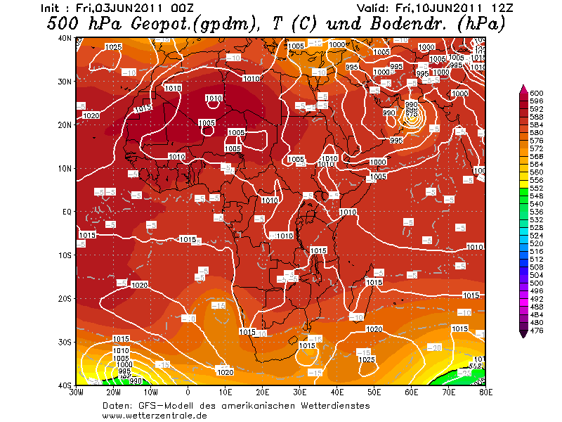
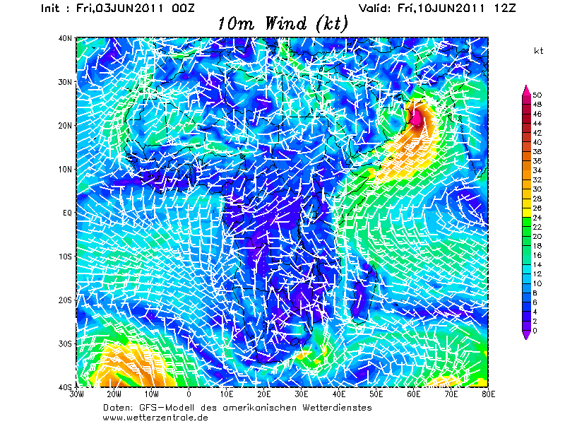
Ik ben benieuwd wat het gebied in de Arabische Zee gaat doen. GFS laat het behoorlijk intensiveren op de lange termijn. Maar elke run is weer verschillend. Op onderstaande kaarten van 10 juni is te zien dat de cycloon voor de kust van Oman ligt.
In 2007 werd dit gebied getroffen door de cycloon Gonu. In Wikipedia is te lezen dat dit de zwaarste tropische cycloon was die ooit in de Arabische Zee is waargenomen en samen met een andere tropische cycloon de zwaarste die ooit in het hele bassin van de noordelijke Indische Oceaan is waargenomen.
Het is afwachten hoe deze cycloon zich gaat ontwikkelen.
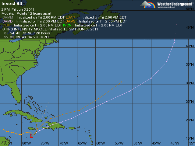
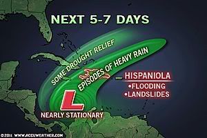
Invest in de Caribische zee is nu 30%
quote:THERE HAS BEEN LITTLE CHANGE TO THUNDERSTORM ACTIVITY ASSOCIATED
WITH A BROAD AREA OF LOW PRESSURE CENTERED ROUGHLY A HUNDRED MILES
SOUTH OF JAMAICA. ENVIRONMENTAL CONDITIONS ARE GENERALLY CONDUCIVE
FOR SOME DEVELOPMENT...AND THERE IS A MEDIUM CHANCE...30 PERCENT...
OF THIS SYSTEM BECOMING A TROPICAL CYCLONE DURING THE NEXT 48
HOURS. HEAVY RAINS COULD CAUSE FLASH FLOODING AND MUD SLIDES OVER
PORTIONS OF HAITI...THE DOMINICAN REPUBLIC...JAMAICA...AND EXTREME
SOUTHEASTERN CUBA OVER THE NEXT COUPLE OF DAYS AS THE LOW REMAINS
NEARLY STATIONARY.
Dat gebied in de Arabische zee lijkt flink te gaan activeren na maandag. Dat kan weleens gaan uitgroeien tot een zware categorie en trekt recht op Oman af. Het is wel lange termijn, maar keert steeds weer terug in de kaarten van GFS.
Afwachten inderdaad... Ze komen niet vaak voor daar. Misschien dat ze wat piratenbootjes laten omslaan 
Zat me net af te vragen waarom ze het altijd invest 93 en 94 noemen daar in de Atlantic... ik heb het ooit geweten maar weet het niet meer, Ik word oud
Zat me net af te vragen waarom ze het altijd invest 93 en 94 noemen daar in de Atlantic... ik heb het ooit geweten maar weet het niet meer, Ik word oud
Hoezo altijd?quote:
Afwachten inderdaad... Ze komen niet vaak voor daar. Misschien dat ze wat piratenbootjes laten omslaan
Zat me net af te vragen waarom ze het altijd invest 93 en 94 noemen daar in de Atlantic... ik heb het ooit geweten maar weet het niet meer, Ik word oud
Elk seizoen begint bij invest 90... Iedereen keer waneer er een gebied komt dat mogelijk een depressie kan worden krijgt dan een nieuwe nummer 91, 92, 93, 94, tot invest 99L.quote:
Volgens mij als ze eenmaal weg zijn en er duiken nieuwe op noemen ze ze ook weer invest 93 of 94 ?
Daarna begint het gewoon weer opnieuw. Komt er naar invest 99L weer een nieuw gebied dan wordt dat weer invest 90.
Gebied in de Oost Pacific is nu opgehoogd naar 90%. Grote kans dat dit dan de eerste storm gaat worden hier. De eerste naam is Adrian.
In de Atlantische Oceaan is de invest opgehoogd naar 40%. Er is een kans dat dit Arlene gaat worden.
In de Atlantische Oceaan is de invest opgehoogd naar 40%. Er is een kans dat dit Arlene gaat worden.
quote:Tropics Activating in Both Caribbean, East Pacific
"The formation of the first named storm in both...basins in the same week would be rather unusual."
The first depression or named storm of this year may not just come to life in the Caribbean this week, but also the eastern Pacific Ocean.
The AccuWeather.com Hurricane Center is busy as the workweek begins, closely monitoring two areas of low pressure for tropical development.
One low is located in the central Caribbean, roughly 175 miles south of Grand Cayman. The other is spinning about 450 miles south of Acapulco, Mexico, in the eastern Pacific.
Both lows have become better organized over the past 36 hours as each churns over warm water.
Due to being in an environment that is more conducive to development, the low in the eastern Pacific will likely win the race and become a tropical depression before the low in the Caribbean.
The eastern Pacific low could strengthen into a depression within the next 24 hours, then should further intensify into Tropical Storm Adrian. Latest computer models even show the low reaching hurricane strength.
The projected path of the strengthening low keeps it over the open waters of the eastern Pacific. However, a track toward the western tip of central Mexico cannot be ruled out.
As wind shear (strong winds high in the atmosphere) lessens, the low in the Caribbean may eventually follow suit and strengthen into a tropical depression this week.
If the low can then continue to strengthen, it would acquire the name "Arlene."
At this point, a range of solutions exists as to where the low will track this week. Some signs point toward the low heading into the south-central Gulf of Mexico, while a track directed at either eastern Cuba or Hispaniola is possible.
Regardless of what the future holds for the low, flooding rain and mudslides poses an immediate danger to Jamaica, southeastern Cuba and Hispaniola.
The formation of the first named storm in both the Atlantic and Eastern Pacific basins in the same week would be rather unusual.
On average, June 9 is when the first tropical storm is named in the Eastern Pacific. In the Atlantic, that date is July 10.
bron: Accuweather
50% inmiddelsquote:Op maandag 6 juni 2011 11:45 schreef aloa het volgende:
In de Atlantische Oceaan is de invest opgehoogd naar 40%. Er is een kans dat dit Arlene gaat worden.
[..]
quote:Evacuaties door noodweer in Dominicaanse Republiek
AMSTERDAM - Meer dan vierduizend mensen zijn in de Dominicaanse Republiek geëvacueerd vanwege noodweer ten zuiden van Jamaica. Hierdoor wordt de Dominicaanse Republiek geteisterd door zware regenbuien.
Twaalf huizen zijn door overstromingen vernield. Nog eens 540 woningen staan blank. Ook in Haïti, Jamaica en Puerto Rico leidde het noodweer tot overstromingen.
De afgelopen dagen zijn er in de Dominicaanse Republiek één en in Haïti twee doden gevallen.
nu.nl
[ Bericht 5% gewijzigd door #ANONIEM op 06-06-2011 22:20:52 ]
Inorbit: zeg dat dan typluie triangeljosti
Beauregard: Een beetje FOK!ker laat het brood door z'n moeder smeren.
Ecosia
ek's 'n flash drive, jy's 'n floppy
Beauregard: Een beetje FOK!ker laat het brood door z'n moeder smeren.
Ecosia
ek's 'n flash drive, jy's 'n floppy
dan verplaats je hem toch?quote:
Inorbit: zeg dat dan typluie triangeljosti
Beauregard: Een beetje FOK!ker laat het brood door z'n moeder smeren.
Ecosia
ek's 'n flash drive, jy's 'n floppy
Beauregard: Een beetje FOK!ker laat het brood door z'n moeder smeren.
Ecosia
ek's 'n flash drive, jy's 'n floppy
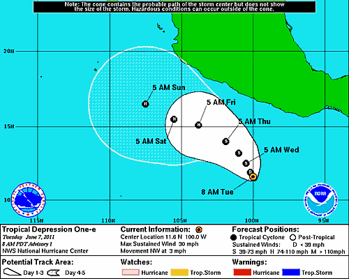
De eerste orkaan in de oost pacific zit er aan te komen.
Het is nu nog een tropische depressie. Op de schaal van beaufort zal het nu amper een windkracht 7 halen. Naar verwachting zal het vrijdag een orkaan zijn en geen bedreiging vormen voor land.
Het is nu nog een tropische depressie. Op de schaal van beaufort zal het nu amper een windkracht 7 halen. Naar verwachting zal het vrijdag een orkaan zijn en geen bedreiging vormen voor land.