WKN Weer, Klimaat en Natuurrampen
Lees alles over het onstuimige weer op onze planeet, volg orkanen en tornado's, zie hoe vulkanen uitbarsten en hoe Moeder Aarde beeft bij een aardbeving. Alles over de verwoestende kracht van onze planeet en tal van andere natuurverschijnselen.


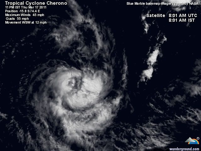
quote:Bureau warns cyclone season far from over
The Bureau of Meteorology says there is a very good chance that more cyclones will hit Australia before the season is out.
Communities in north-west Queensland are preparing for category one Cyclone Yasi, which crossed the coast as a category five storm overnight and left a trail of destruction.
The towns of Tully, Mission Beach, Cardwell, Silkwood and Innisfail bore the brunt of the monster storm's 285kph winds but there are no reports of deaths or serious injuries.
The director of the bureau's National Meteorological and Oceanographic Centre, Chris Ryan, says Cyclone Yasi has generally behaved as predicted so far.
He says Yasi was more intense than both Cyclone Tracy and Cyclone Larry.
"For the Queensland coast this is an exceptional storm. Its intensity looks like it's the most intense for many decades, perhaps going back before we had satellite imagery to properly measure the intensity of cyclones," he said.
The La Nina system which sparked the cyclone season is still well and truly kicking and Mr Ryan says more cyclones could be on the way.
"The waters all around tropical Australia are still abnormally warm," he said.
"The predictions for the general activity and the monsoon that covers northern Australia at this time of year are that it will actually intensify to some extent over the next couple of weeks.
"So there's certainly every chance that we will see one or more cyclones on either or both sides of the continent over the next couple of months."
He says he would not be surprised if another big cyclone forms.
"The situation hasn't changed to make it any less susceptible to severe cyclones developing again," he said.
As emergency crews and residents begin to assess the damage in coastal regions, Mr Ryan says the bureau is conscious of the risk of false alarms, but at this stage the warnings have matched people's experiences.
"The problem of false alarms and crying wolf is one that we're very conscious of with all of the warnings that we issue," he said.
"In this case we'll have to see how it's perceived. But from everything that I've heard, people who were in the midst of this have all said it was the worst they've ever experienced.
"It was terrifying. And that matches what we were leading them to believe would happen."
Mr Ryan says while the bureau is not yet able to retrieve wind speed measurements, it has estimated speeds of up to 290kph on the coast.
He says it is unusual for a cyclone to remain a category three once it has moved inland for as long as Yasi did.
"Cyclones tend to start to deteriorate very quickly once they lose that energy source from the ocean," he said.
"Yasi, being so big, and to some extent more self-contained, has lasted longer. It was still category two... some 11 or so hours after it crossed the coast. That's pretty unusual. And we're not expecting it to drop below category one until late [Thursday]."
14 doden door overstromingen op Sri Lanka.
Een miljoen mensen op de vlucht voor het water in Sri Lanka
Misschien een nieuw systeem bij de Tonga eilanden.
Een miljoen mensen op de vlucht voor het water in Sri Lanka
Misschien een nieuw systeem bij de Tonga eilanden.


Ik las vanmorgen dat op de lange termijn Australie weer te maken gaat krijgen met een cycloon
Weer of geen weer, altijd actueel www.onweer-online.nl
dat is wel een open deur zegquote:Op woensdag 9 februari 2011 10:30 schreef meteo-online het volgende:
Ik las vanmorgen dat op de lange termijn Australie weer te maken gaat krijgen met een cycloon
Inorbit: zeg dat dan typluie triangeljosti
Beauregard: Een beetje FOK!ker laat het brood door z'n moeder smeren.
Ecosia
ek's 'n flash drive, jy's 'n floppy
Beauregard: Een beetje FOK!ker laat het brood door z'n moeder smeren.
Ecosia
ek's 'n flash drive, jy's 'n floppy
quote:New Cyclone threat for Australia?
The GFS long range weather maps, used by New Zealand and Australian forecasters but produced in America, are picking that a new cyclone may hit northern Australia early next week says WeatherWatch.co.nz.
The long range models, which have been highly accurate this summer, predict a weak low will cross the northern tip of Queensland on Friday then rapidly intensify into a cyclone by Monday in the Gulf of Carpentaria. While this part of Australia is not heavily populated the tropical storm could then head south, dumping more torrential rain on normally dry inland parts, such as Alice Springs, which is this year receiving huge amounts of rain.
Flooding from ex-cyclone Yasi has already caused problems across inland/western Queensland and the Northern Territories. Of short term interest the Bureau of Meteorology have "high" confidence that another cyclone will form west of Western Australia in the coming days. The good news is that the predicted cyclone is expected to travel well west of the continent and away from land.
However the long range models show plenty of unstable weather conditions along Australia's north western coastline with one model predicting another low developing west of Darwin and heading inland at the end of next week. Again, this part of Australia isn't heavily populated but the lows have the potential to continue to string of flash flooding across inland regions says WeatherWatch.co.nz.
Weer of geen weer, altijd actueel www.onweer-online.nl
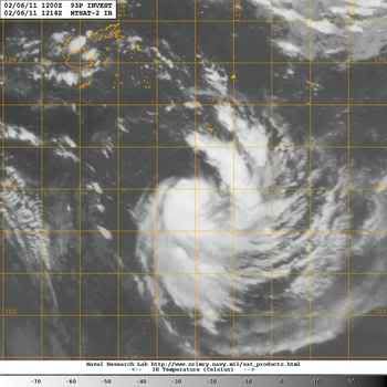
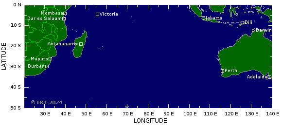
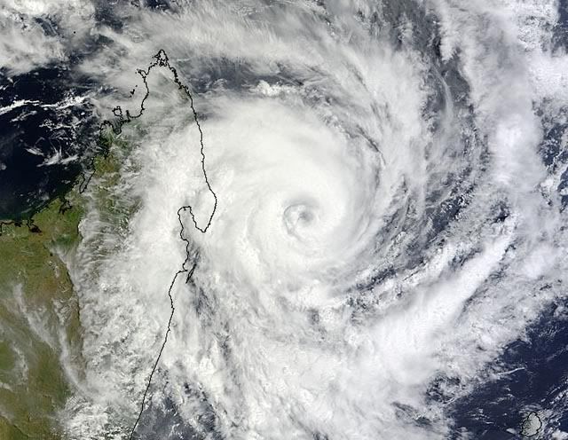
Kaartje voor 14 februari laat een systeem bij Madagascar zienquote:
Bij Madagascar lijkt zich ook wat te ontwikkelen nu, redelijke kans tot ontwikkeling
[ afbeelding ]
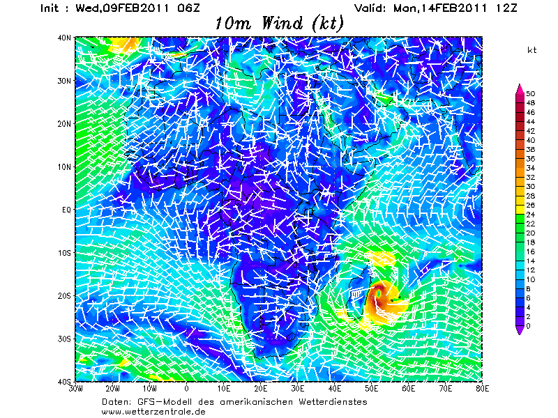
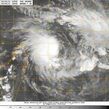
Systeem bij Madagascar. Volgens de verwachting gaat het een categorie 2 worden.
Naam van deze orkaan is BINGIZA
[ Bericht 4% gewijzigd door #ANONIEM op 09-02-2011 22:36:57 ]
Naam van deze orkaan is BINGIZA

[ Bericht 4% gewijzigd door #ANONIEM op 09-02-2011 22:36:57 ]
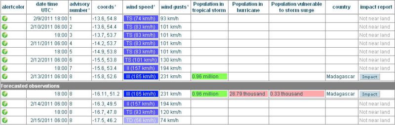
Volgens onderstaande plaatje gaat het wel een categorie 2 worden. Systeem ligt haast stil. Het verplaatst zich met minder dan 2 km/uur.
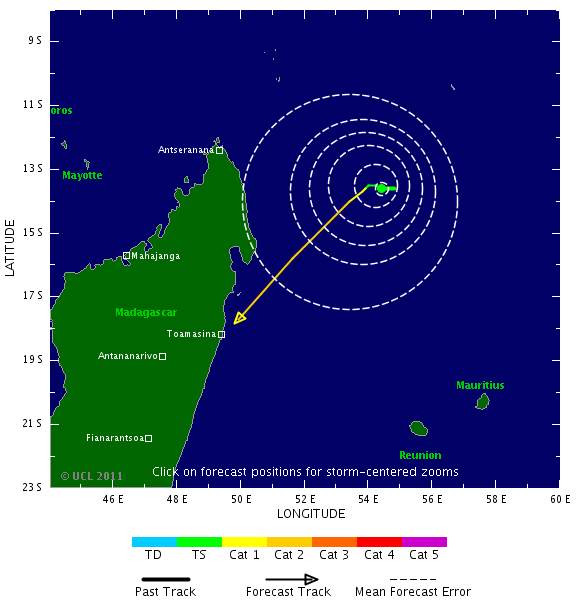
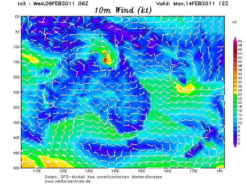
Australie krijgt ook weer te maken met een cycloon. Deze ontstaat boven de golf van Carpentaria en gaat landfall maken in Queensland.
kaartje van 15 februari
kaartje van 15 februari

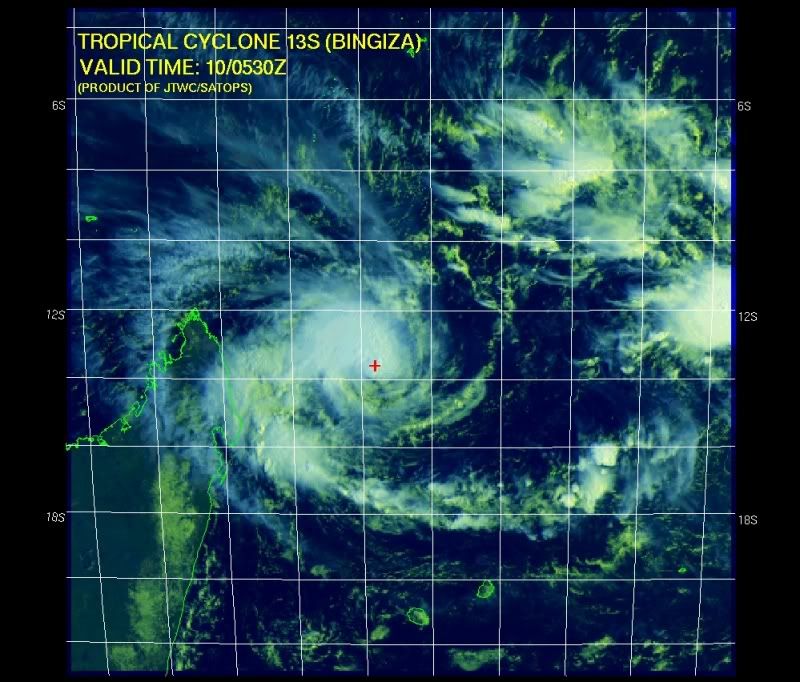
Bengiza is gewoon een categorie 3 geworden 
Ze beweegt zo langzaam, genoeg warmte om haar te voeden
dacht dat madagascar er wel goed vanaf kwam na die downgrade van deze week
maar nu is het gewoon een zeer gevaarlijke orkaan
Ze beweegt zo langzaam, genoeg warmte om haar te voeden
dacht dat madagascar er wel goed vanaf kwam na die downgrade van deze week
maar nu is het gewoon een zeer gevaarlijke orkaan

Bingiza gaat landfall maken als een categorie 3.
Nu een windveld van 185 km met windstoten tot 231 km/uur.
Nu een windveld van 185 km met windstoten tot 231 km/uur.
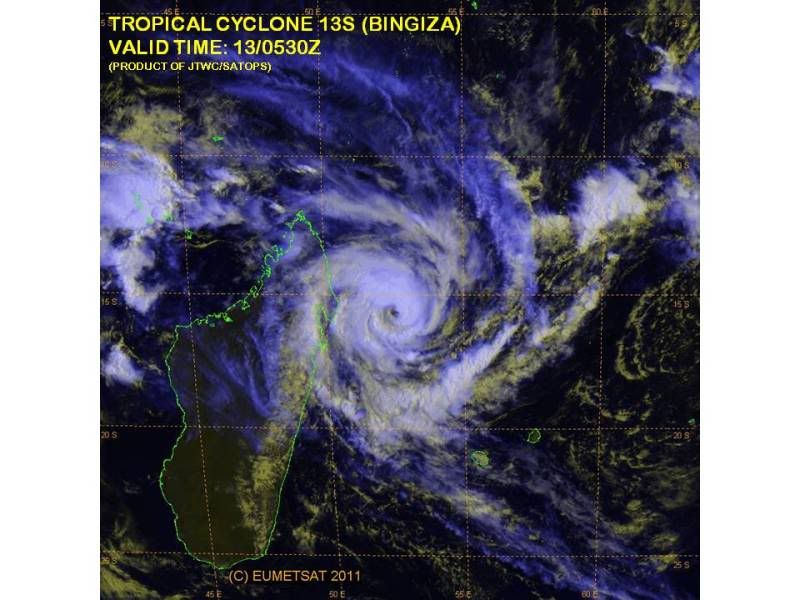
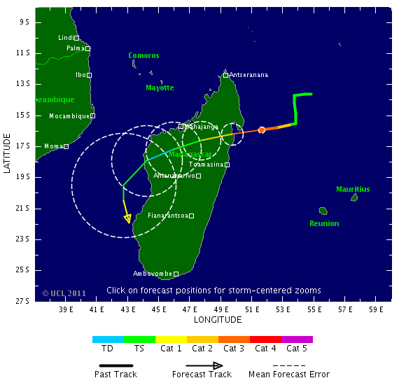
Tropical Cyclone Bingiza roared ashore over Northern Madagascar early today as a dangerous Category 3 hurricane with 115 mph winds. Recent microwave imagery from NASA's TRMM satellite shows that Bingza had a large region of heavy rains of 0.4 - 0.7 inches per hour in the eyewall and inner spiral bands at landfall. Rainfall amounts of up to 8 inches are being predicted along Bingza's path over northern Madagascar for the coming 24 hours by NOAA's automated tropical cyclone rainfall prediction system. Rains of this magnitude are capable of causing dangerous flooding in Madagascar, and the storm's winds and storm surge likely caused serious damage in the moderately populated area where the storm came ashore. Bingiza will weaken today as it traverses the island, but is expected to re-intensify once it emerges over the Mozambique Channel between Africa and Madagascar on Tuesday, where sea surface temperatures are about 0.4°C above average. As the storm skirts the western coast of Madagascar Tuesday and Wednesday, the island will receive additional very heavy rains on its mountainous slopes. Madagascar suffers from extensive deforestation, and a storm like Bingiza is capable of causing very dangerous floods.
Bingiza is just the second tropical cyclone in the Southwest Indian Ocean (west of 90E) during the 2010 - 2011 season; this is an unusually low amount of activity for the basin. The only other storm so far this season has been Tropical Cyclone Abele (29 Nov - 4 Dec 2010), a Category 1 storm that stayed out to sea. Bingiza is the 4th major (Category 3 or stronger) tropical cyclone world-wide this year.
Wunderground
[ Bericht 2% gewijzigd door #ANONIEM op 14-02-2011 19:41:04 ]
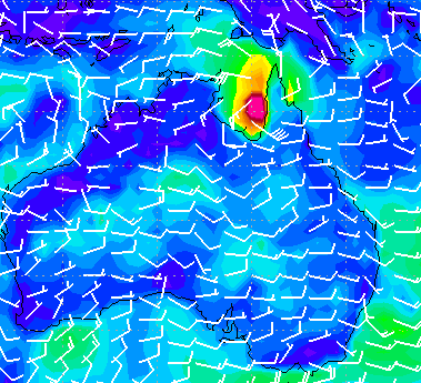
2 systemen bij Australie. Hoge kans dat deze een cycloon gaan worden.

quote:Potential Cyclones:
At 2pm WST a developing tropical low [16U] was located near 19.1S 112.7E, about
350 kilometres north northwest of Exmouth and moving towards the west southwest
at 24 kilometres per hour. Refer to the latest Tropical Cyclone Advice
[IDW24100] for details.
Likelihood of this system being a tropical cyclone in the Western Region:
Wednesday :High
Thursday :High
Friday :High
quote:Potential Cyclones:
A developing Tropical Low, 1002 hPa, was located over the western Top End near
13.2S 130.5E, approximately 100km south southwest of Darwin at 12:30 pm CST on
15 February and moving slowly west northwest. The low is expected to move north
or north northwest into the Beagle Gulf and may develop into a tropical cyclone
during Wednesday.
Likelihood of this system being a tropical cyclone in the region on:
Wednesday: High.
Thursday: High.
Friday: High.

Orkaanseizoen in één minuut
Het was vorig jaar een druk orkaanseizoen in de Atlantische regio. Sinds 2005 - het jaar van orkaan Katrina - waren er nooit meer orkanen. Liefst twaalf stormen werden in 2010 tot orkaan uitgeroepen. Dit filmpje toont het hele seizoen in één minuut.
Het orkaanseizoen was vorig jaar ook opmerkelijk, omdat voor het eerst sinds 1998 nog eens drie orkanen tegelijk actief waren. Igor, Julia en Karl kregen die eer. Igor en Julia waren zelfs samen een orkaan van categorie 4 en dat was sinds 1926 niet meer gebeurd. (gb)
hln
[ Bericht 15% gewijzigd door #ANONIEM op 15-02-2011 19:14:11 ]
Het was vorig jaar een druk orkaanseizoen in de Atlantische regio. Sinds 2005 - het jaar van orkaan Katrina - waren er nooit meer orkanen. Liefst twaalf stormen werden in 2010 tot orkaan uitgeroepen. Dit filmpje toont het hele seizoen in één minuut.
Het orkaanseizoen was vorig jaar ook opmerkelijk, omdat voor het eerst sinds 1998 nog eens drie orkanen tegelijk actief waren. Igor, Julia en Karl kregen die eer. Igor en Julia waren zelfs samen een orkaan van categorie 4 en dat was sinds 1926 niet meer gebeurd. (gb)

hln
[ Bericht 15% gewijzigd door #ANONIEM op 15-02-2011 19:14:11 ]


Ziet er gaaf uit zegquote:Op dinsdag 15 februari 2011 19:11 schreef aloa het volgende:
Orkaanseizoen in één minuut
Het was vorig jaar een druk orkaanseizoen in de Atlantische regio. Sinds 2005 - het jaar van orkaan Katrina - waren er nooit meer orkanen. Liefst twaalf stormen werden in 2010 tot orkaan uitgeroepen. Dit filmpje toont het hele seizoen in één minuut.
Het orkaanseizoen was vorig jaar ook opmerkelijk, omdat voor het eerst sinds 1998 nog eens drie orkanen tegelijk actief waren. Igor, Julia en Karl kregen die eer. Igor en Julia waren zelfs samen een orkaan van categorie 4 en dat was sinds 1926 niet meer gebeurd. (gb)
hln
Doe mee met het voorspellen van het weer!
Weekvoorspelling | Week 12 (invullen tot 16-03 - 11:59)
Maandvoorspelling Maart (Inzendingen gesloten)
Jaarvoorspelling 2025 / 2026
Weekvoorspelling | Week 12 (invullen tot 16-03 - 11:59)
Maandvoorspelling Maart (Inzendingen gesloten)
Jaarvoorspelling 2025 / 2026
Nieuwe cycloon raast over Noord-Australië
(Novum/AP) - De cycloon Carlos heeft in de Noord-Australische stad Darwin voor hevige regenval en windstoten met snelheden tot 130 kilometer per uur gezorgd. Bomen en elektriciteitspalen gingen tegen de vlakte.
Verscheidene mensen moesten uit hun auto gered worden en één man raakte gewond toen hij door een vallende boom werd geraakt. Scholen en overheidsgebouwen sloten hun deuren, maar evacuaties waren niet nodig, aldus de autoriteiten.
Het oog van de storm liep op drie kilometer langs de stad, maar bleef wel boven zee. Volgens de nationale meteorologische dienst kan de cycloon donderdag terugkeren naar Darwin.
Twee weken geleden verwoestte de veel krachtigere cycloon Yasi meerdere steden in de noordoostelijke staat Queensland.
Nieuws.nl
Cycloon Carlos raast door Australische stad Darwin
De Australische stad Darwin, in het noorden van het land, is vandaag getroffen door de cycloon Carlos. Rukwinden van 110 kilometer per uur en hevige regen teisterden de stad.
Verschillende scholen en de luchthaven werden gesloten terwijl de stad met 120.000 inwoners getroffen werd door overstromingen en stroomonderbrekingen, zo melden lokale media. Volgens tv-zender ABC liepen de straten onder water en werden bomen uit de grond gerukt. Naar verluidt vielen er geen gewonden.
Op een schaal van een tot vijf werd Carlos geklasseerd als een categorie 1, aldus de meteorologische diensten. De cycloon volgt twee weken na de gelijkaardige storm Yasi, die voor 1 miljard Australische dollar aan schade veroorzaakt heeft. (afp/adv)
HLN
564 mm in 56 uur tijd
[ Bericht 0% gewijzigd door #ANONIEM op 16-02-2011 14:55:59 ]
bronquote:Darwin residents warned to prepare but not panic
Tropical Cyclone Carlos is continuing to dump record levels of rain on Darwin as the city's residents deal with cyclonic weather.
More than 400 millimetres of rain fell on the city overnight, forcing the evacuation of 11 houses, and emergency services are preparing to use sandbags to protect more houses which face flooding when the tide peaks tonight.
At this stage the cyclone isn't expected to intensify above category two but the Top End does have a reputation for unpredictable cyclones. Michael Coggan reports from Darwin.
MICHAEL COGGAN: Darwin is familiar with cyclones; rarely does a wet season go by without one or two cyclones reminding Top Enders of the destruction caused by Cyclone Tracy in 1974. But Cyclone Carlos is different, even before it was officially declared a cyclone the weather system cut a swath through the Top End capital.
The combination of more than 400 millimetres of rain and winds, in excess of 100 kilometres per hour, have knocked down trees and powerlines across the city. Main roads have been cut by floodwaters and a 6.6 metre high tide this afternoon is expected to add to the 11 homes inundated overnight.
[ Bericht 0% gewijzigd door #ANONIEM op 16-02-2011 14:55:59 ]
quote:Tropical Cyclone Dumps Feet of Rain on Australia
Feet of rain from Tropical Cyclone Carlos have already inundated Australia's Top End with more rain to come before the cyclone finally departs later this week.
Carlos unleashed 22.24 inches of rain on Darwin, the capital city of Australia's Northern Territory, in 56 hours, ending at 5:30 p.m. Wednesday local time (3 a.m. EDT).
The 13.37 inches that fell in 24 hours, ending at 6:30 p.m. EDT Tuesday, set a new all-time daily rainfall record. The old record was held by Jan. 3, 1997 and its 11.43 inches.
The torrential rain has inundated homes and streets in and around Darwin. The Associated Press reports that several people had to be rescued from cars that became stalled in flood waters.
Gusty winds, which peaked at 61 mph in Darwin Tuesday morning EDT, worsened the situation by downing trees and power lines.
One man sustained injuries after being struck by a falling tree.
Darwin and other locations across Australia's Top End will be faced with more flooding problems over the next couple of days as Carlos slowly meanders southwestward and unleashes additional torrential rain.
The heavy rain will finally end Friday into Saturday as Carlos shifts into northern Western Australia.
Interaction with land will prevent Carlos from strengthening into a powerful cyclone. However, more damage to trees and power lines may ensue as tropical storm-force wind gusts continue to accompany the cyclone.
Accuweatherquote:Carlos, and Now a New Australia Cyclone Threat
Even as Carlos continues to inundate Darwin, a new tropical cyclone, dubbed Dianne, has taken shape off northwestern Australia, from whence it will eventually threaten the nation's west with damaging winds and flooding rain.
Wednesday morning, EST, the center of T.C. Dianne lay about 300 miles northwest of Learmonth, near Cape North West, Western Australia. Highest sustained winds were at least 40 mph. The storm was nearly stationary.
The atmospheric setting will favor intensification, even rapidly so, during the next two days, so Dianne could become the equivalent of a strong hurricane.
Storm movement will become southward, maybe on a path intersecting the west coast of Australia near the end of the week.
Direct high wind impact will be confined to open seas for at least the next two days. However, moisture linked to Dianne will trigger local flooding downpours over far-western Australia, most of which is sparsely settled desert.
Depending on track, Dianne could eventually spark an outbreak of widespread flooding rain and even damaging winds.
[ Bericht 0% gewijzigd door #ANONIEM op 16-02-2011 14:53:25 ]


quote:Darwin sets its all-time 24-hour rainfall record
Darwin, Australia suffered its greatest 24-hour rainfall in its history on Wednesday, when a deluge of 13.4 inches (339.4 mm) hit the city when Tropical Cyclone Carlos formed virtually on top of city and remained nearly stationary. Over the past three days, Carlos has dumped a remarkable 25.37" (644.6 mm) of rain on the Darwin (population 125,000), capital of Australia's Northern Territory. Carlos has moved slowly inland today, and continues to dump rain on Darwin, but these rains will gradually subside over the next few days as the storm weakens and moves farther inland. Not surprisingly, the rains have triggered major flooding in the Darwin area. The heavy rains in Darwin are due to the very slow motion of the storm, which has been able to keep a significant portion of its circulation over the warm 30°C (86°F) waters off the coast. These water temperatures are near normal for this time of year. Australia's west coast is also watching Tropical Cyclone Dianne, which is expected to remain offshore as it moves southwards, parallel to the coast.
quote:Tropical Cyclone Bingiza makes a 2nd landfall in Madagascar
On Monday, Tropical Cyclone Bingiza roared ashore over Northern Madagascar as a dangerous Category 3 hurricane with 115 mph winds. The storm is being blamed for six deaths, has left 15,000 homeless, and has destroyed 8,500 buildings. After re-emerging over the waters of the Mozambique Channel between Africa and Madagascar on Tuesday, Bingiza re-intensified, and made a second landfall along the southwest coast of Madagascar early today as a tropical storm. Bingiza is expected to dissipate over Madagascar tomorrow, but not before dumping very heavy rains capable of causing additional flooding problems on Madagascar's deforested mountain slopes.
Bingiza is just the second tropical cyclone in the Southwest Indian Ocean (west of 90E) during the 2010 - 2011 season; this is an unusually low amount of activity for the basin. According to an email I received from Sebastien Langlade of the tropical cyclone forecasting office on La Reunion Island, January 2011 was the first January since accurate records began in 1998 that the Southwest Indian Ocean failed to record a single tropical storm. The only other storm in the basin so far this season has been Tropical Cyclone Abele (29 Nov - 4 Dec 2010), a Category 1 storm that stayed out to sea. Bingiza was the 4th major (Category 3 or stronger) tropical cyclone world-wide this year.
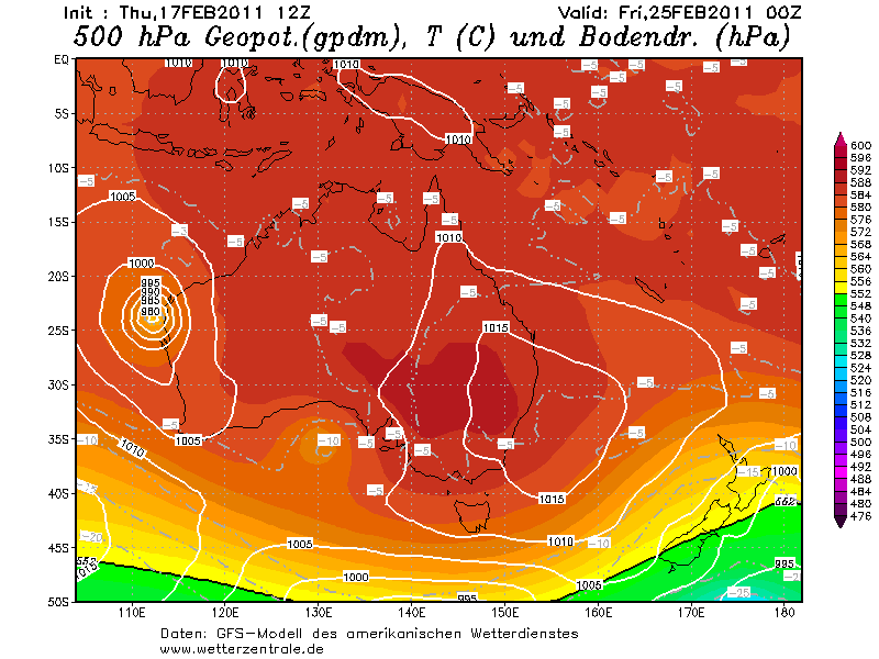
Als je naar de kaarten van gfs kijkt is Australie ook nog lang niet verlost van Carlos. Dit systeem trekt volgens dit model nog langs de noordkust en westkust.
kaartje van volgende week vrijdag. Carlos ligt dan aan de westkust
[ Bericht 4% gewijzigd door #ANONIEM op 17-02-2011 20:30:05 ]
kaartje van volgende week vrijdag. Carlos ligt dan aan de westkust
[ Bericht 4% gewijzigd door #ANONIEM op 17-02-2011 20:30:05 ]

quote:Carlos hits North Australia
River Daly peaked early in the day, flooding homes in the small town of Nauiyu, south of Darwin.
Local reports state animals in the area were snatched by crocodiles swimming in flood waters.
Authorities predict flood levels will not recede for at least four days. Makeshift shelters have been set up to house the community.
The Bureau of Meteorology has warned that Cyclone Carlos has now intensified into a Category One cyclone.

dan die japan nog raken?quote:
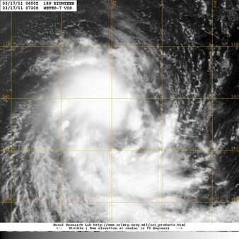
Nummer 18 in de Indische Oceaan.
[ afbeelding ]
Dan is het feest compleet daar
Inorbit: zeg dat dan typluie triangeljosti
Beauregard: Een beetje FOK!ker laat het brood door z'n moeder smeren.
Ecosia
ek's 'n flash drive, jy's 'n floppy
Beauregard: Een beetje FOK!ker laat het brood door z'n moeder smeren.
Ecosia
ek's 'n flash drive, jy's 'n floppy

Indische Oceaan ligt nog wel een eindje van Japan afquote:
[..]
dan die japan nog raken?
Dan is het feest compleet daar
quote:Igor and Tomas retired Atlantic Huricane names
The hurricane committee of the World Meteorological Organization (WMO), which issues the list of potential names for tropical cyclones to be used every six years for both the Atlantic and eastern North Pacific basins, has decided to retire the Atlantic names Igor and Tomas.
Igor was a classic Cape Verde hurricane, reaching Category 4 strength with 155 miles per hour (250 kilometers per hour) winds on September 14, 2010, while located about 600 miles (965 kilometers) east of the northern Leeward Islands. The storm weakened to a Category 1 hurricane when it struck Bermuda on September 19.
Igor grew in size, with the area of tropical-storm-force winds becoming roughly 750 nautical miles (1389 kilometers) wide and made landfall on September 21 near Cape Race in Newfoundland. It was the most damaging hurricane on that island in 75 years and killed three people along its path. Damage in Newfoundland was placed at almost $200 million U.S. dollars.
Tomas, meanwhile, became a hurricane on October 30, shortly after striking Barbados. It strengthened to a Category 2 storm striking St. Vincent and St. Lucia, becoming the latest hurricane on record to strike the Windward Islands.
After weakening to a tropical depression over the central Caribbean Sea, Tomas regained Category 1 strength on November 5 and moved between Jamaica and the southwest peninsula of Haiti, through the Windward Passage. It weakened just below hurricane strength before reaching the Turks and Caicos Islands. Fourteen people are confirmed as dead, or missing, on St. Lucia. Total damage there is estimated to be around $500 million U.S. dollars. Heavy rains associated with Tomas triggered floods and landslides in Haiti, where meteorological services state that the death toll was 35.
If the WMO hurricane committee had not decided to scrap the names, Igor and Tomas in the Atlantic would have appeared again in 2016. Ian and Tobias will now take their place instead.
The only time that there is a change in the list of names is if a storm is so deadly or costly that the future use of its name on a different storm would be inappropriate for reasons of sensitivity. If that occurs, then at an annual meeting by the WMO committee, the offending name is stricken from the list and another name is selected to replace it.
The lists are re-cycled every six years, i.e., the 2010 list will be used again in 2016.