WKN Weer, Klimaat en Natuurrampen
Lees alles over het onstuimige weer op onze planeet, volg orkanen en tornado's, zie hoe vulkanen uitbarsten en hoe Moeder Aarde beeft bij een aardbeving. Alles over de verwoestende kracht van onze planeet en tal van andere natuurverschijnselen.


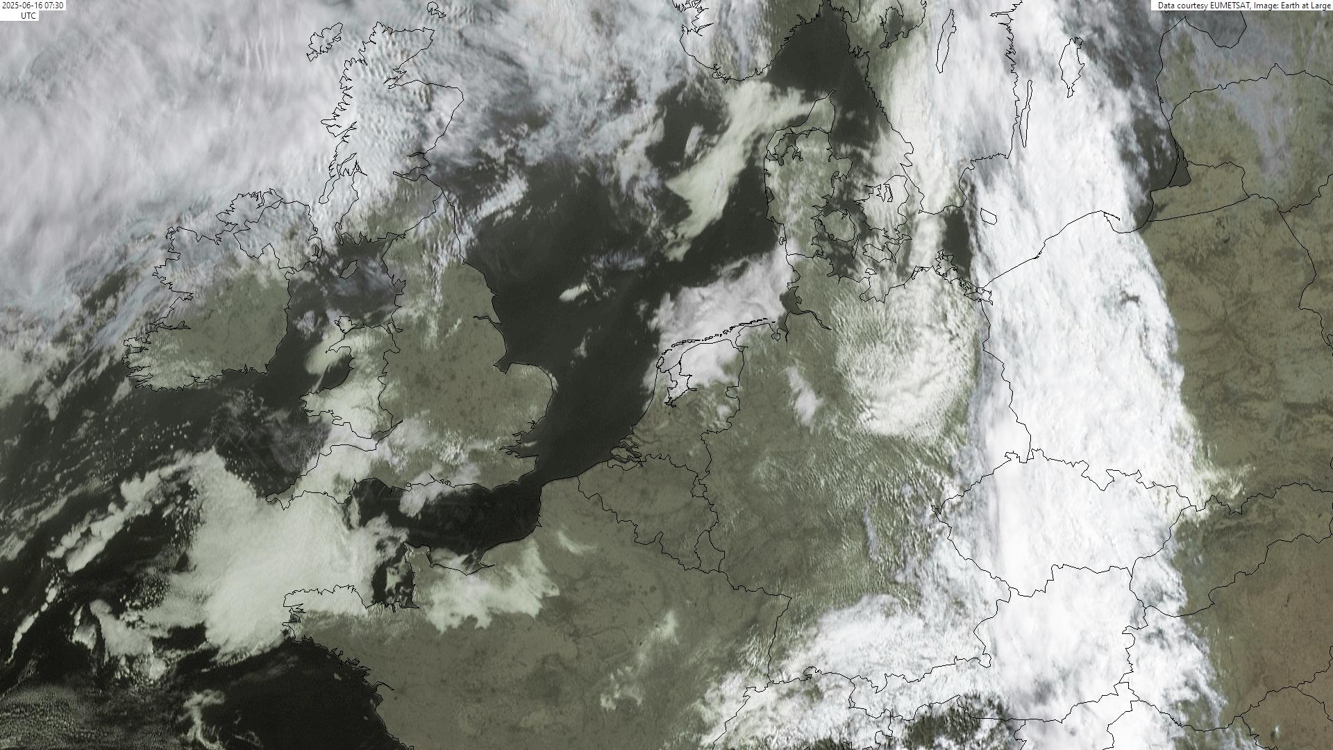
Volg de aswolk op radar
http://www.sat24.nl/Eyjafjallajokull-volcano.aspx
Camerabeelden (met vallend gesteente)
Huidige asverspreiding boven Europa
Laatste webcam plaatjes


Vorige deeltjes in deze reeks
Fotocollecties
Aardbevingsoverzicht IJsland
Externe links
Frontpage FOK
Verwante DE-links
OP staat hier
[ Bericht 2% gewijzigd door Frutsel op 07-05-2010 09:28:22 ]
De uitbarsting van de IJslandse vulkaan Eyjafjallajökull zit opnieuw in een explosieve fase en "aanzienlijke" concentraties as zijn op komst. Daar hebben IJslandse meteorologen en geofysici voor gewaarschuwd. Er is geen enkel teken dat er een einde komt aan de uitbarsting, klinkt het. Die uitbarsting duurt al sinds 14 april en veroorzaakt een aswolk die het luchtverkeer boven delen van Europa eerder al enkele dagen verhinderde.
De uitbarsting is weer veranderd: de lava vloeit niet meer en de meeste magma wordt weggeslingerd door explosies in de krater", aldus het Icelandic Met Office and Institute of Earth Science. "Daardoor is er een aspluim en die veroorzaakt een aswolk die zware gevolgen kan hebben. De nieuwe aswolk zou in eerste instantie gevolg hebben voor vluchten naar Amerika. De Irish Aviation Authority (IAA) spreekt van een "massive ash cloud" die bijna 1.500 kilometer lang is en 1.100 kilometer breed. Die hangt boven de Atlantische Oceaan en drijft naar het Zuidwesten.
Bron Hln
Zo te zien op de radar waait de wolk straks over ierland naar het Oosten weg?
Komen we er dit keer vanaf zonder teveel geannuleerde vluchten.
Komen we er dit keer vanaf zonder teveel geannuleerde vluchten.
Ironisch eigenlijk, dat een land als IJsland wat zo milieuvriendelijk is dankzij geothermie-centrales, alsnog zo enorm vervuilend is omdat ze die geothermie te danken hebben aan vulkanen...
censuur :O
quote:Nieuwe enorme aswolk
De uitbarsting van de IJslandse vulkaan Eyjafjallajökull zit opnieuw in een explosieve fase en "aanzienlijke" concentraties as zijn op komst. Daar hebben IJslandse meteorologen en geofysici voor gewaarschuwd.
"Er is geen enkel teken dat er een einde komt aan de uitbarsting", klinkt het. Die uitbarsting duurt al sinds 14 april en veroorzaakt een aswolk die het luchtverkeer boven delen van Europa eerder al enkele dagen verhinderde.
"De uitbarsting is weer veranderd: de lava vloeit niet meer en de meeste magma wordt weggeslingerd door explosies in de krater", aldus het Icelandic Met Office and Institute of Earth Science. "Daardoor is er een aspluim en die veroorzaakt een aswolk die zware gevolgen kan hebben."
De nieuwe aswolk zou in eerste instantie gevolg hebben voor vluchten naar Amerika. De Irish Aviation Authority (IAA) spreekt van een "massive ash cloud" die bijna 1.500 kilometer lang is en 1.100 kilometer breed.
Die hangt boven de Atlantische Oceaan en drijft naar het Zuidwesten.


Terug Vind Pyroclastischestroom
You're not your job. You're not how much money you have in the bank. You're not the car you drive. You're not the contents of your wallet. You're not your fucking khakis. You're the all-singing, all-dancing crap of the world.

Die infrarood beelden zien eruit alsof ze van Mars komen 
Dare to unleash my rage..
That's my secret Captain... I'm always angry...
There's nothing like a trail of blood, to find your way back home.
That's my secret Captain... I'm always angry...
There's nothing like a trail of blood, to find your way back home.
Ziet er wel mooi uitquote:Op vrijdag 7 mei 2010 11:06 schreef Burner82 het volgende:
Die infrarood beelden zien eruit alsof ze van Mars komen

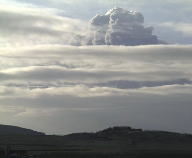
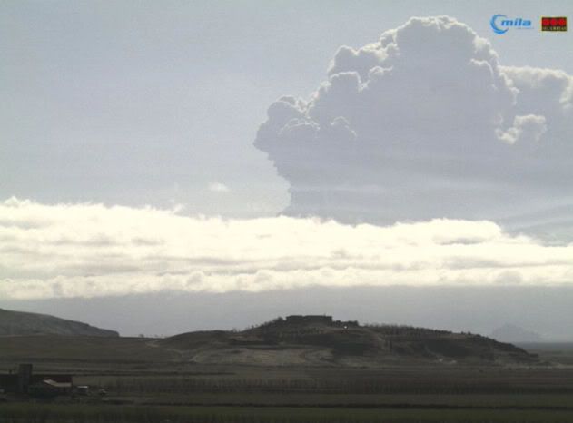
Nog een actuele:

[ Bericht 10% gewijzigd door basst2005 op 07-05-2010 11:31:59 ]

Damn, Net nu ik maandag vertrek richting New York.
Wel leuke link met infra rood beelden.
Dacht dat dit ondertussen beetje achter de rug was, maar ......
Iemand een idee wat de impact gaat zijn op het luchtverkeer?
Wel leuke link met infra rood beelden.
Dacht dat dit ondertussen beetje achter de rug was, maar ......
Iemand een idee wat de impact gaat zijn op het luchtverkeer?
Ah hier zijn jullie. 
Dagrapport van gisteren:
Dagrapport van gisteren:
http://www2.norvol.hi.is/page/ies_Eyjafjallajokull_eruptionquote:Eruption in Eyjafjallajökull - Status Report: 18:00 GMT, 06 May 2010
Icelandic Meteorological Office and Institute of Earth Sciences, University of Iceland
Compiled by: Sigurlaug Hjaltadóttir, Björn Oddsson, Egill Axelsson, Matthew J. Roberts, Sigrún Hreinsdóttir, Halldór Björnsson, Bergþóra S. Þorbjarnardóttir.
Based on:
IMO seismic monitoring; IES-IMO GPS monitoring; IMO hydrological data; IMO weather radar measurements, MODIS satellite image; reports from sent through the IMO web site, information from the Icelandic Coast Guard flight yesterday.
Eruption plume:
Height (a.s.l.): The ash plume observed from commercial pilots between 0530h and 0800h: 30,000 ft/9km. ICG helicopter flight between 13h and 14h: sometimes under 20,000 ft (where there is a cloud bank) and oscillates up into the cloud bank (over 9 km). The height of the plume varies from 4-6 km according to the weather radar. Icelandair Cargo flight at
18:00 climbing towards east from Keflavík estimates height at 21- 22,000ft.
Heading: East-south-east over land, then to the south (assessed from AVHRR figure from NOAA at 0435h and 1154h).
Colour: A police officer from Hvolsvöllur, stationed at Rauðafell, observed the ash plume to be dark-gray. Observation from ICG: dark.
Tephra fallout: Considerable ashfall at Þykkvabæjarklaustur in Álftaver (at a distance of 65-70 km), (everything has turned black). It has not been established whether the ash cloud south of Eyjafjallajökull is ashfall or ash that has already fallen and is being blown from the ground. Ashfall seems to start midway through Mýrdalssandur.
Lightning: No detections today over the eruption site.
Noises: No noise can be heard at Hvolsvöllur. No noise was heard at Seljavellir at noon. Noise heard at Heggstaðanes (200 to the north).
Meltwater:
Discharge from Gígjökull decreases further and meltwater seems to be running from the eastern side of the glacier. This is different from tuesdays meltwater were water was running from the west side. Lava flow might be changing the direction of meltwater flow. Such changes should be taken seriously with regard to possible outbursts due to accumulation of meltwater. Discharge at the old Markarfljóts bridge is decreasing. It has now been verified that increase in electrical conducitvity in Jökulsá á Sólheimasandi was caused by volcanic ash penetrating the glacier and the meltwater. This rules out the possibility of sulphur rich gas from magma entering the meltwater.
Conditions at eruption site:
The lava stream down Gígjökull has been stationary for the
last two days. Explosive activity has increased and the cinder cone
continues to build up in the northern most ice cauldron.
Seismic tremor:
Tremor levels continued to decrease yesterday and this morning. They are now similar to what they were in the first phase of the eruption, 14 to 17 April.
Earthquakes:
Earthquake activity is still being recorded. At least 10 earthquakes have been located since midnight. Most of the earthquakes are sourced beneath or south of the top crater in the eruptive conduit that has formed since 3 May. Most of the earthquakes are less than magnitude 2, the biggest M2.2. Three events have been recorded beneath the southeastern ice cap, depth uncertain.
GPS deformation:
Measurements from around Eyjafjallajökull show continued horizontal displacement. South of the eruption, stations THEY and SVBH have begun to drift southward, whereas FIM2, located east of the eruption, shows northward motion. No further northward motion has been observed at STE2, located to the north. Today's displacement pattern suggests deformation beneath the southeastern part of Eyjafjallajökull.
Other remarks:
Between 14 April and 5 May no signals (exept diurnal and long-period earth tides) are seen at strain-station Stórólfshvoll, ~35 km WNW of the eruption.
Overall assessment:
Explosive activity has increased and effusive part has decreased for the last two days. This results in a higher eruption column with increased tephra fallout. There are no signs that the eruption is about to end.
be nice or go away

Volgens mij zijn alle vliegvelden overal in Europa gewoon open
en is de uitbarsting er een van " lik mijn vestje "
en is de uitbarsting er een van " lik mijn vestje "
75 topics = FIN
Beetje een vaag plaatje, delen van de aswolk vlakbij de vulkaan hebben dezelfde kleur als de lager gelegen omgeving van de vulkaan, dat zou betekenen dat ze dezelfde temperatuur hebben als dit een infrarood beeld is.quote:
DUBLIN - De vulkaan onder de IJslandse gletsjer Eyjafjallajökull roert zich weer. Door nieuwe uitbarstingen is er nieuwe as in de lucht gekomen in de nacht van donderdag op vrijdag, waardoor een aantal transatlantische vluchten de komende dagen wordt omgeleid.
De Europese luchtverkeersleider Eurocontrol liet weten dat het gebied waar zich een hogere asconcentratie bevindt zich vrijdag uitspreidt van IJsland tot mogelijk aan de westkust van het Iberische schiereiland.
Op sommige plaatsen bevindt de as zich op een hoogte van meer dan tien kilometer. Ook het KNMI spreekt van meer activiteit in de afgelopen dagen.
Ondertussen gaan in Ierland de luchthavens weer open. Het vliegveld van Dublin was eerder weer in gebruik genomen. Sinds dinsdag ondervond het vliegverkeer hinder van de aswolk boven Ierland, Schotland en Noord-Ierland. In Schotland werd het luchtruim donderdag al vrijgegeven.
De rookkolom van de vulkaan onder de IJslandse gletsjer steeg dinsdag tot 10 kilometer hoogte, wat hoger is dan de circa 9 kilometer vorige maand toen het Europese vliegverkeer dagenlang stillag.
De intensiteit van de uitbarsting is echter stukken minder dan de activiteit in april, maar waarnemers sluiten niet uit dat de uitbarsting de komende dagen intensiever wordt.
© ANP
Bron nu.nl

Er wordt omheen gevlogen.quote:Op vrijdag 7 mei 2010 15:15 schreef Frutsel het volgende:
vliegen daar nu ook geen vliegtuigen dan?
of vliegen die te hoog en/of erom heen?

De kraterwand zelf kan je ook niet zien.quote:
[..]
Beetje een vaag plaatje, delen van de aswolk vlakbij de vulkaan hebben dezelfde kleur als de lager gelegen omgeving van de vulkaan, dat zou betekenen dat ze dezelfde temperatuur hebben als dit een infrarood beeld is.
Huilen dan.
Heeft de koelere maand mei misschien ook te maken met de vulkaanuitbarsting? Het is gewoon hier begin maart brrrrrrrr.... 

TVP 
Op donderdag 6 september 2012 @ 21:41 schreef Shakkara het volgende:
Uiteraard is het volgens Rutte en consorten de schuld van een imaginair links kabinet dat we ooit ergens in het verleden gehad schijnen te hebben.
Uiteraard is het volgens Rutte en consorten de schuld van een imaginair links kabinet dat we ooit ergens in het verleden gehad schijnen te hebben.
Nee, gewoon een Noordenwind. Wel vervelend.quote:Op vrijdag 7 mei 2010 15:58 schreef luckyb1rd het volgende:
Heeft de koelere maand mei misschien ook te maken met de vulkaanuitbarsting? Het is gewoon hier begin maart brrrrrrrr....
Op donderdag 6 september 2012 @ 21:41 schreef Shakkara het volgende:
Uiteraard is het volgens Rutte en consorten de schuld van een imaginair links kabinet dat we ooit ergens in het verleden gehad schijnen te hebben.
Uiteraard is het volgens Rutte en consorten de schuld van een imaginair links kabinet dat we ooit ergens in het verleden gehad schijnen te hebben.
Dus de aswolk komt weer hier heen? Ah eindelijk weer retro mooie blauwe luchten zonder vliegtuigstrepen..quote:Op vrijdag 7 mei 2010 16:00 schreef Prutzenberg het volgende:
[..]
Nee, gewoon een Noordenwind. Wel vervelend.
Kleine aardbeving in de Waddenzee boven groningen! (bron)
Zou de Zuidwalvulkaan wakker worden.
[ Bericht 17% gewijzigd door Prutzenberg op 08-05-2010 00:55:54 ]
Zou de Zuidwalvulkaan wakker worden.
[ Bericht 17% gewijzigd door Prutzenberg op 08-05-2010 00:55:54 ]
Op donderdag 6 september 2012 @ 21:41 schreef Shakkara het volgende:
Uiteraard is het volgens Rutte en consorten de schuld van een imaginair links kabinet dat we ooit ergens in het verleden gehad schijnen te hebben.
Uiteraard is het volgens Rutte en consorten de schuld van een imaginair links kabinet dat we ooit ergens in het verleden gehad schijnen te hebben.
Voor degene die hem nog niet kennen, de vodafone web cam: http://www.vodafone.is/eldgos
Men verwacht blijkbaar nogal wat met het plaatsen van de infrarood camera.
Als het goed is ben ik eind juli daar
Men verwacht blijkbaar nogal wat met het plaatsen van de infrarood camera.
Als het goed is ben ik eind juli daar

quote:Op vrijdag 7 mei 2010 16:10 schreef Prutzenberg het volgende:
Kleine aardbeving in de Waddenzee boven groningen! (bron)
Zou de Zuidwalvulkaan wakker worden.
De 'bovenwind' om het maar even zo te noemen staat geloof ik zuidwest, dus alleen de transatlantische vluchten leiden eronder, iig meoten ze omvliegen.quote:Op vrijdag 7 mei 2010 16:02 schreef luckyb1rd het volgende:
[..]
Dus de aswolk komt weer hier heen? Ah eindelijk weer retro mooie blauwe luchten zonder vliegtuigstrepen..
Daar hoorden zij engelen zingen... AJAX! ***

Jezus Christus, niet weer.
Donderdag vlieg ik richting Atlanta en dat moet doorgaan.
Kan er niet zo'n deksel op als bij het olielek in de Golf van Mexico?
Donderdag vlieg ik richting Atlanta en dat moet doorgaan.
Kan er niet zo'n deksel op als bij het olielek in de Golf van Mexico?
quote:Iceland's volcano sends more ash towards Europe
REYKJAVIK, Iceland — Iceland's Eyjafjoell volcano threatened European skies with a new ash cloud Friday raising the risk of more flight cancellations, officials said.
"Renewed and more intensive ash eruptions took place overnight and as a result, the area of potential higher ash contamination is forecast to extend from Iceland as far south as the western edge of the Iberian Peninsula during the day," Eurocontrol, the European intergovernmental air traffic control coordinator, said.
"Lava has stopped running from the crater and the eruption is now again an explosive eruption," Icelandic geologist Bjoern Oddson said.
"When there's more explosive activity, the ash does become finer and if the activity increases, it could possibly cause problems in Europe's airspace," he said, noting "the ash is spreading to the south-east" of Iceland.
Late Thursday, Icelandic meteorologists and geophysicists warned Eyjafjoell would emit a larger ash cloud after renewed activity, though Oddson said it had stabilised overnight.
"Right now, we're not seeing nearly as much ash fall as in the first few days of the eruption", which paralysed European flight traffic for a week from April 14, he said.
The ash, at sufficient concentrations, poses a hazard for plane engines.
According to the Brussels-based Eurocontrol, the areas where the volcanic ash concentration were likely to exceed engine tolerance levels were to the west of north-west Europe.
"Transatlantic flights are being re-routed south of the affected area which could cause delays to these flights."
The ash cloud was predicted to reach up to 35,000 feet (some 10,500 metres), far higher than in recent days and thus affecting more overflying planes.
The cloud caused Ireland to shut its airspace from 2300 GMT on Thursday to 1200 GMT Friday, the third closure in as many days.
The Faroe Islands, a Danish territory in the North Atlantic, also shut airspace from Thursday night until at least 0000 GMT Saturday.
The Portuguese air traffic agency NAV said ash was expected in the country's airspace north of Lisbon later Friday but would have a limited effect, causing only some rerouting.
Last month the Icelandic volcanic caused travel chaos, with airspaces closed over several European nations.
It was the biggest aerial shutdown in Europe since World War II, with more than 100,000 flights cancelled and eight million passengers affected. The airline industry said it lost some 2.5 billion euros.

tvp
volgende week weer vliegen naar Newark, dus ik ben benieuwd
volgende week weer vliegen naar Newark, dus ik ben benieuwd
04-08-11, 02-02-12, 20-06-14, 13-08-15

Webcam op http://eldgos.mila.is/eyjafjallajokull-fra-thorolfsfelli is aangepast, is volgens mij een andere camera/locatie?
Morgen terugvliegen vanuit Noorwegen naar Nederland. Lijkt me op dit moment geen gevaar voor mijn vlucht morgen. Maar wel klote dat ie iedere keer als ik moet vliegen actief word. Heb al 6 dagen in China vast gezeten en nu begint dat ding weer te kutten..
Al die huilies die moeten vliegen. 
Sorry hoor, ziet er redelijk uit momenteel.
Sorry hoor, ziet er redelijk uit momenteel.
Who the fuck can sleep with all this shit going on?

Zelfde locatie alleen nu ingezoomd op de gletsjertong.quote:Op vrijdag 7 mei 2010 22:17 schreef basst2005 het volgende:
Webcam op http://eldgos.mila.is/eyjafjallajokull-fra-thorolfsfelli is aangepast, is volgens mij een andere camera/locatie?
Deze camera heeft nog wel een compleet overzicht vanaf dezelfde locatie: http://www.vodafone.is/eldgos
Die site is meestal erg traag (bij mij), ik kijk daarom meestal hier:quote:Op vrijdag 7 mei 2010 22:38 schreef mouzzer het volgende:
[..]
...
Deze camera heeft nog wel een compleet overzicht vanaf dezelfde locatie: http://www.vodafone.is/eldgos
http://www.sat24.nl/Eyjafjallajokull-volcano.aspx
Deze heeft hetzelfde beeld, maar wordt iets minder vaak geupdate.
Het ziet er weer ouderwets indrukwekkend uit, ook die webcam van Hvolsvelli, vorige keer dat ik keek was er nog geen aswolk te zien, nu zou ik er niet meer willen wonen
En nu maar hopen dat het niet meer zo mistig gaat worden.
En nu maar hopen dat het niet meer zo mistig gaat worden.
Als het niet met een hamer te repareren is, is het een elektrisch probleem.


Hoe ziet de komende week eruit wat betreft vluchten naar london? Mijn supervisor gaat op vakantie daar, en ik hoop toch echt dat hij aankomt (hebben wij rust )
Dare to unleash my rage..
That's my secret Captain... I'm always angry...
There's nothing like a trail of blood, to find your way back home.
That's my secret Captain... I'm always angry...
There's nothing like a trail of blood, to find your way back home.
Nieuwe kaart (voor morgenochtend vroeg):quote:Op vrijdag 7 mei 2010 22:14 schreef Tourniquet het volgende:
Vliegroutes gaan een flink stuk zuidelijker dan 'normaal':
[ afbeelding ]

Moeten de vliegtuigen nog zuidelijker..
quote:
Valt vooralsnog wel mee.quote:In de West-Spaanse regio Galicië gaan zaterdag drie vliegvelden dicht wegens vulkaanas uit IJsland.
Who the fuck can sleep with all this shit going on?
Waar kun je die kaarten vinden?quote:Op vrijdag 7 mei 2010 23:27 schreef basst2005 het volgende:
[..]
Nieuwe kaart (voor morgenochtend vroeg):
[ afbeelding ]
Moeten de vliegtuigen nog zuidelijker..
Via deze site: http://www.jeppesen.com/aviation/personal/aviation-weather.jspquote:
En dan kiezen voor "High Level Significant Forecast"
Zie deze pagina voor uitleg over de gebruikte synbolen: http://www.jeppesen.com/images/general/HighLevelSymbols.gif
Staan ook nog een paar andere interessante kaarten bij.
[ Bericht 15% gewijzigd door basst2005 op 08-05-2010 07:30:35 ]
bronquote:Assessment - 07 May 2010 19:30
Explosive activity seems to have decreased since yesterday. The ash plume does not rise as high into the air and is lighter in colour.
Steam rises from the lava tongue under Gígjökull, which is a sign that ice is melting in the tunnel, but to a much lesser degree than when the lava flow was at its peak. The cinder cone continues to build up around the eruption vent in the ice cauldron. The lava flow to the north has been stagnant for the past two days.
Tremor levels are low, comparable to yesterday and the period 14-17 April. Earthquakes are still being recorded at 5-13 km depth, but fewer than yesterday. There are no signs that the eruption is ending.
For more detailed information, see the status report issued collectively by the Icelandic Meteorological Office and the Institute of Earth Sciences at 16:00 today.
Ik keek eerder vandaag ook, zwart.. werkzaamhedenquote:
Het is mistig zeker.
Geen klap te zien momenteel
Ze doen het nu wel, maar er hangt een dikke mist voor. Die warmtecamera is blauw.quote:Op zaterdag 8 mei 2010 08:10 schreef indahnesia.com het volgende:
[..]
Ik keek eerder vandaag ook, zwart.. werkzaamheden


Even een tvp, voor een vlucht morgen.
Op dinsdag 21 februari 2012 22:30 schreef JoanFranka het volgende:
PINGUINS RULEREN!! Dat zijn echt een van de grappigste dieren op aarde hahahaa
PINGUINS RULEREN!! Dat zijn echt een van de grappigste dieren op aarde hahahaa
En een tvp, dinsdagochtend is het de bedoeling om via Madrid naar Lima te vliegen... voor een zeer strak geplande reis  .
.
[b]Op dinsdag 4 maart 2008 13:44 schreef Zhenar het volgende:[/b]
Spelletjeshater! :( Prinses der Duisternis! :r Eter van kinderen en puppies!!!!! :'( !!!!!
Spelletjeshater! :( Prinses der Duisternis! :r Eter van kinderen en puppies!!!!! :'( !!!!!
quote:SPAIN: Santiago de Comp., Vigo, Coruna, Asturias, Santander, Valladolid, Burgos and Salamanca airports closed until further notice
http://twitter.com/eurocontrol/status/13596165997
hehe vodafone heeft die webcam geclaimd..." disaster ads" by google
http://www.mrwonkish.nl Eurocrisis, Documentaires, Economie
TVP, ik ga morgen voor een week naar Rome...
It's 106 miles to Chicago, we've got a full tank of gas, half a pack of cigarettes, its dark, and we're wearing sunglasses. Hit it.
Hier kan ik die wolk een beetje volgen.quote:Op zaterdag 8 mei 2010 11:08 schreef indahnesia.com het volgende:
[..]
Ja en? Kun je dat niet beter melden in het TRV forum?
It's 106 miles to Chicago, we've got a full tank of gas, half a pack of cigarettes, its dark, and we're wearing sunglasses. Hit it.
quote:Ash eruptions are ongoing and the area of potential ash contamination is expanding in particular between the ground and 20,000 feet. As a result, during the day, the area affected by volcanic ash is expected to extend from Iceland, south to Portugal and possibly as far east as Barcelona and Marseille. Airports are closed or expected to close in northern Portugal, the north of Spain and parts of southern France. The latest ‘Air Ash Concentration Charts’ describing those areas where no-fly zone proposals have been made to the EUROCONTROL Member States are attached.
Transatlantic flights are being re-routed around the affected area which is causing substantial delays to these flights. The reduction of available airspace is also impacting flights arriving in or departing from the Iberian Peninsula and delays could be expected.
Update on European air traffic situation - 12.00 CET
Staan ook kaartje op die url.quote:08 May 2010
As of 12.00 CET on 8 May 2010, EUROCONTROL has the following update to make with regard to the situation of air traffic in Europe:
Today EUROCONTROL expects approximately 25,000 flights within the European area.
Ash eruptions are ongoing and the area of potential ash contamination is expanding in particular between the ground and 20,000 feet. As a result, during the day, the area affected by volcanic ash is expected to extend from Iceland, south to Portugal and possibly as far east as Barcelona and Marseille. Airports are closed or expected to close in northern Portugal, the north of Spain and parts of southern France. The latest ‘Air Ash Concentration Charts’ describing those areas where no-fly zone proposals have been made to the EUROCONTROL Member States are attached.
Transatlantic flights are being re-routed around the affected area which is causing substantial delays to these flights. The reduction of available airspace is also impacting flights arriving in or departing from the Iberian Peninsula and delays could be expected.
On Friday 7 May, there were 30,342 flights within the EUROCONTROL CFMU area, in line with normal traffic levels.

tvp voor vlucht op maandag
<a href="https://www.youtube.com/watch?v=yIl_jGh-LWE" target="_blank" rel="nofollow">Afleidingsmanoeuvre</a>

Oei. Wij vliegen de 13e, deze forecast is voor de 9e. Ik heb geen idee of de windrichting zo blijft, maar met deze snelheid ziet het er naar uit dat die strook de 13e precies boven de Benelux hangt.quote:Op zaterdag 8 mei 2010 13:34 schreef basst2005 het volgende:
Nieuwe as voorspelling, 't komt erg dichtbij morgen:
[ afbeelding ]
Lekker dan.
dat blijft toch een machtig gezicht hoorquote:Op zaterdag 8 mei 2010 12:01 schreef aloa het volgende:
Het huidige beeld van de vulkaan
[ afbeelding ]
04-08-11, 02-02-12, 20-06-14, 13-08-15
Lekker, zit nu in een Thomas Cook vliegtuig.
We zouden gaan vertrekken maar moeten nu wachten tot 20.00 LOKALE tijd.
Ze zijn Brussel aan het vragen wat ze kunnen doen.
We zouden gaan vertrekken maar moeten nu wachten tot 20.00 LOKALE tijd.
Ze zijn Brussel aan het vragen wat ze kunnen doen.
Is Londen al dicht?! Mijn ouders stappen vanavond op het vliegtuig vanaf Barbados naar Londen toe! en mn moeder vind vliegen al niet leuk
Op donderdag 3 september 2009 23:06 schreef Luctor.et.Emergo het volgende:
niet? En je hebt er nooit werk van gemaakt? Of vind je haar er niet leuk uitzien.
Op donderdag 3 september 2009 23:10 schreef The_Dean het volgende:
Het is mijn zus, gast.
niet? En je hebt er nooit werk van gemaakt? Of vind je haar er niet leuk uitzien.
Op donderdag 3 september 2009 23:10 schreef The_Dean het volgende:
Het is mijn zus, gast.
op welke luchthaven ben je nu dan?quote:Op zaterdag 8 mei 2010 16:34 schreef W1ckeDxt het volgende:
Lekker, zit nu in een Thomas Cook vliegtuig.
We zouden gaan vertrekken maar moeten nu wachten tot 20.00 LOKALE tijd.
Ze zijn Brussel aan het vragen wat ze kunnen doen.
op die webcam wordt de rook iig donkerder, althans daar lijkt het op. Kan ook zijn omdat er wat minder zon is.
http://www.mrwonkish.nl Eurocrisis, Documentaires, Economie
een fokker uit lyon??quote:Op zaterdag 8 mei 2010 15:32 schreef Prego het volgende:
Tvp voor m'n vlucht de 11e (Lyon - Amsterdam)
:\
ik ook uit lyon! wat doe je hier dan?quote:Op zaterdag 8 mei 2010 17:04 schreef Prego het volgende:
[..]
yep
en nee want: "AIRBUS INDUSTRIE A318"
Ik zit nu in Reus, Spanje.quote:Op zaterdag 8 mei 2010 16:40 schreef 045represent het volgende:
[..]
op welke luchthaven ben je nu dan?
Alles zit hier dicht en zitten nu weer in het vliegveld zelf, kan best zijn dat het tot 21.00 gaat duren.
Ik hoop iig dat ik vandaag nog thuis kom.
Eerlijk gezegd heb ik er een hard hoofd in dat jij nog thuiskomt vandaag...quote:Op zaterdag 8 mei 2010 17:19 schreef W1ckeDxt het volgende:
[..]
Ik zit nu in Reus, Spanje.
Alles zit hier dicht en zitten nu weer in het vliegveld zelf, kan best zijn dat het tot 21.00 gaat duren.
Ik hoop iig dat ik vandaag nog thuis kom.
En ik heb er ook een hard hoofd in dat ik morgen wél op vakantie kan (naar Lanzarote)
Dagrapport van gisteren:
http://www2.norvol.hi.is/page/ies_Eyjafjallajokull_eruption
Het lijkt er op dat de Eyjafjallajökull nog niet klaar is, ik hoop dat iedereen die wacht op mensen die moeten vliegen of zelf moeten vliegen snel duidelijkheid krijgen.
Hij blijft beven nu.
Lol, de wolk torent weer mooi boven de rest uit nu, het lijkt er op dat hij nog meer uitspuugt dan vanmiddag.
http://eldgos.mila.is/eyjafjallajokull-fra-hvolsvelli/
Ik ben wel benieuwd naar die van vandaag.quote:Eruption in Eyjafjallajökull - Status Report: 16:00 GMT, 07 May 2010
Icelandic Meteorological Office and Institute of Earth Sciences, University of Iceland
Compiled by: Sigurlaug Hjaltadóttir, Rikke Pedersen, Björn Oddsson, Ólafur Freyr Gíslason, Guðrún Larsen, Benedikt G. Ófeigsson, Matthew J. Roberts, Bergthóra S. Thorbjarnardóttir.
Based on:
IMO seismic monitoring; IES-IMO GPS monitoring; IMO hydrological data; IMO weather radar measurements, MERIS satellite image; reports from sent through the IMO web site, information from commercial flights.
Eruption plume:
Height (a.s.l.): 7 km according to IMO weather radar measurements at 1155h. Commercial flight heading towards Keflavík at 15:18h: 20,000- 25,000ft (7-7.6 km).
Heading: Southeast
Colour: Colour: Dark at the bottom, otherwise light gray.
Tephra fallout: Considerable in Vík ashfall began at 21h last night; ashfall reaches to ~55-60 km from eruption site, midway through Mýrdalssandur.
Lightning: No detections today over the eruption site.
Noises: No reports
Meltwater:
During the last 24 hours there have been no flash floods from Gígjökull measured at Markarfljótsbrú. Electrical conductivity has been decreasing and daily fluctuations in discharge and water temperature have been observed. The electrical conductivity in Jökulsá á Sólheimasandi which has been traced to ash contamination from the glacier is still quite high. An increase in discharge has been observed in rivers in the area around Mýrdals- and Eyjafjallajökull due to higher ambient temperature.
Conditions at eruption site:
The ash plume is lower now than yesterday. The wind affects the plume and ashfall is less. The cinder cone continues to build up around the eruption vent in the ice cauldron. The lava flow to the north has been stagnant past two days.
Seismic tremor:
Tremor levels are low, comparable to yesterday and the period on 14 - 17 April.
Earthquakes:
Earthquakes are still being recorded at 5-13 km depth, but fewer than yesterday.
GPS deformation:
Measurements from around Eyjafjallajökull indicate no major net discplaceaments, suggesting a stabilization of the surface deformation since yesterday.
Other remarks:
Grainsize analysis of samples taken of ash that fell on May 3rd at 64 km distance from the eruption site shows that about 5 % of the ash is smaller than 10 micron (aerosols). This is a considerable decrease of fine particles compared to ash from April 15th (25% aerosols) sampled at a similar distance. The grain size analysis was carried out by Nýsköpunarmiðstöð Íslands.
Overall assessment:
Explosive activity seems to have decreased since yesterday. The ash plume does not rise as high into the air and is lighter in colour. Steam rises from the lava tongue under Gígjökull which is a sign that ice is melting in the tunnel, but to a much lesser degree than when the lava flow was at its peak. There are no signs that the eruption is ending.
http://www2.norvol.hi.is/page/ies_Eyjafjallajokull_eruption
Het lijkt er op dat de Eyjafjallajökull nog niet klaar is, ik hoop dat iedereen die wacht op mensen die moeten vliegen of zelf moeten vliegen snel duidelijkheid krijgen.
http://www.luchtvaartnieuws.nl/news/default.asp?cat=all&id=34808quote:Aswolk treft ook Portugal en Frankrijk
08-05-2010
BRUSSEL - De aswolk uit IJsland waait zaterdag niet alleen over het noorden van Spanje, maar ook Portugal en Zuid-Frankrijk kampen met problemen. Dat meldde de Europese luchtverkeersleider Eurocontrol. Luchthavens in het noorden van Portugal en Spanje en het zuiden van Frankrijk zijn gesloten of zullen de komende uren sluiten. "Erupties doen zich nog steeds voor en het gebied waar de as de lucht vervuild, breidt zich uit", aldus een verklaring van Eurocontrol.
In Spanje zijn inmiddels zeker vijftien luchthavens dicht. Deze blijven in elk geval tot het einde van de middag gesloten. Vluchten vanuit Nederland naar Noord-Amerika of Zuid-Europa moeten rekening houden met vertragingen.
(c) ANP

Hij blijft beven nu.
Lol, de wolk torent weer mooi boven de rest uit nu, het lijkt er op dat hij nog meer uitspuugt dan vanmiddag.
http://eldgos.mila.is/eyjafjallajokull-fra-hvolsvelli/
be nice or go away

Hmm, estimated time zou 5.41PM zijn, dat was 3 kwartier geleden, hij staat nog wel op sceduled en niet op cancelled, misschien heb je nog geluk. Sterkte iig.quote:Op zaterdag 8 mei 2010 18:15 schreef W1ckeDxt het volgende:
ik heb inderdaad het gevoel dat ik niet meer thuis kom yah.
http://www.flightstats.com/go/FlightStatus/flightStatusByAirport.do?airportCode=REU&airportQueryType=0
Hier kun je in de gaten houden wat de status is.
be nice or go away
[ Bericht 28% gewijzigd door detulp050 op 08-05-2010 18:37:28 ]
[b]Mijn Reviews[/b]
Ex-crew.
Ex-crew.
Ik hoop het echt niet... Ben half jaar bezig met voorbereiden van deze reis. Kutvulkaan  .
.
[b]Op dinsdag 4 maart 2008 13:44 schreef Zhenar het volgende:[/b]
Spelletjeshater! :( Prinses der Duisternis! :r Eter van kinderen en puppies!!!!! :'( !!!!!
Spelletjeshater! :( Prinses der Duisternis! :r Eter van kinderen en puppies!!!!! :'( !!!!!
"I HATE ICELAND!"quote:
Ik hoop het echt niet... Ben half jaar bezig met voorbereiden van deze reis. Kutvulkaan
Niet alles wat geen nut heeft
heeft geen zin.
Stijn De Paepe
heeft geen zin.
Stijn De Paepe
Hmm, hoe lang zou je gaan? Is de trein dan geen optie? Als je via een reisbureau hebt geboekt kunnen ze je misschien omboeken. Niet geschoten is altijd mis natuurlijk.quote:Op zaterdag 8 mei 2010 18:30 schreef detulp050 het volgende:
Volgens de Spaanse overheid kan dit tot volgende week aanhouden. Zeg maartegen mijn vakantie Mallorca van a.s. maandag
@XcUZ_Me hopelijk klaart het op.....
be nice or go away