WFL Wetenschap, Filosofie, Levensbeschouwing
Discussieer hier over alle aspecten van de wetenschap, filosofische problemen en zaken van levensbeschouwelijke aard.


bronquote:
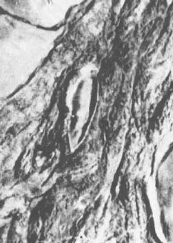
Satellietbeelden van de Ark van Noach
Gepubliceerd op woensdag 15 maart 2006
Hoog op de berg Ararat in het oosten van Turkije bevindt zich een vreemd verschijnsel dat wel eens het overblijfsel kan zijn van de bijbelse Ark van Noach.
Het gevaarte ligt op bijna 5000 meter hoog op de noordwest hoek van de berg Ararat en is bijna verzonken in gletsjer ijs. Op het eerste gezicht lijkt het een gewone rotsformatie.
Intrigerend verschijnsel
Foto's genomen door vliegtuigen, spionagesatellieten en commerciële aardobservatiesatellieten voeden een intensief debat naar de aard van het intrigerend verschijnsel. Het kan een geologische speling zijn van de natuur, een schaduwspel, een door mensenhanden gemaakte structuur of gewoon niets. Maar wat het verzonken ding is, is nog niet duidelijk. Toekomstige beelden van observatiesatellieten zouden meer duidelijkheid moeten brengen.
Volgens Porcher Taylor, een vroegere analist van de Amerikaanse veiligheidsdiensten, zou het wel eens de Ark van Noach kunnen zijn. De ark die 40 dagen en nachten rondzwierf over de zee, tijdens de zondvloed zoals beschreven in het bijbelboek Genesis.
Dertien jaar
Hij leidt tijdens zijn al dertien jaar geleden gestarte studie uit beschikbare foto's af dat de proporties van de ‘anomalie’ overeenstemmen met de lengte- en breedtematen die in de bijbel zijn opgegeven van het schip waarmee Noach de mens en diersoorten moest redden van de zondvloed.
“Ik noem het mijn satelliet archeologie-project”, aldus Taylor. “Iets wat is begonnen als een gewone zoektocht, gebeurt nu door het GeoEye's Ikonos ruimtevaartuig, de Canadese Radarsat en verschillende satellietbeelden van Amerikaanse ruimteonderzoekers.”
Scheepvaart
Hij houdt vol dat het in ieder geval om iets gaat dat door mensen is gemaakt en mogelijk iets met scheepvaart van doen heeft. Mogelijk is het dan ook iets met bijbelse proporties, zo wordt Taylor aangehaald. Het doel van de onderzoeker is duidelijk, door middel van beelden uit zien te vogelen wat het precies is daar in de hoge pieken van de berg Ararat. “Toen ik in 1993 begon had ik geen vooroordeel of geen agenda, ik wil gewoon uitzoeken wat het is”.
Uiteraard zijn er ook sceptici. "Interpretatie van foto's is een kunst" is de verklaring van Faroek el-Baz, directeur van het Universitair Centrum voor Aardobservatie in Boston. “Zonlicht kan rare schaduwen vormen. Van alle afbeelding die ik tot nu toe heb gezien, denk ik dat het gaat om een rotspartij, die zich gedeeltelijk in de schaduw bevindt en waar ijs en sneeuw overheen ligt”.

Interessant zeg. Ik neig wel meer de kant van de sceptici te kiezen. Zien wat je wilt zien. Maar goed, hopelijk bieden toekomstige beelden meer duidelijkheid.
Wat denken jullie ervan?


Volgens mij kunnen we het daar beter bij laten.quote:Op het eerste gezicht lijkt het een gewone rotsformatie.
Now I'm walking on the sunnyside of the street
Dit verhaal is inmiddels tientallen jaren oud en duikt om de zoveel tijd weer de kop op. Het is gewoon een stuk rots.
'Nuff said
Is dit niet een ontzettend oud verhaal
Dan bedoel ik natuurlijk niet Noachs ark maar dat over die berg.
Dan bedoel ik natuurlijk niet Noachs ark maar dat over die berg.
Ik zie er ook niets in, als je even verder zoekt moet je vanuit de ruimte tientallen gelijke objecten kunnen vinden volgens mij.
Het verhaal is al zooo oud, laat ze het maar eens uitzoeken dan.
Look who's here everyone! It's Zoidberg, the lovable tramp!

Het mag niet van de Turkse overheid ofzo. Maar als die toestemming verlenen is het probleem zo opgelost en weten ze wat het is.

Daar zie ik persoonlijk een grote anus in maar dat kan ook aan mij liggenquote:Op woensdag 15 maart 2006 13:44 schreef suravida het volgende:
http://volcano.und.nodak.edu/vwdocs/volc_images/img_ararat.html
Mijn Snape wat doe je !
Niet zo dol op Amerika uit de kluiten gewassen kolonie vol randebielen.
Asperger and proud !
Niet zo dol op Amerika uit de kluiten gewassen kolonie vol randebielen.
Asperger and proud !
Zijn ze bang dat er anders niemand meer in Allah geloofd?quote:Op woensdag 15 maart 2006 13:43 schreef Ultralaser het volgende:
Het mag niet van de Turkse overheid ofzo. Maar als die toestemming verlenen is het probleem zo opgelost en weten ze wat het is.
Niet om het een of ander, maar is dit verhaal (niet dat van de ark zelf, maar de foto's) niet al erg oud?
Kan me een soortgelijk verhaal herinneren van een (lange) tijd terug...
Kan me een soortgelijk verhaal herinneren van een (lange) tijd terug...
You can't convince a believer of anything; for their belief is not based on evidence, it's based on a deep seated need to believe
C. Sagan
C. Sagan
Dat God een groot feestje gaat geven?quote:Op woensdag 15 maart 2006 13:55 schreef Omkron het volgende:
Hmmm.. wat zou dit betekenen als dit inderdaad de Ark uit de bijbel blijkt te zijn?
'Nuff said
Dat de dinosaurussen zijn uitgestorven omdat ze niet op de ark pasten...quote:Op woensdag 15 maart 2006 13:55 schreef Omkron het volgende:
Hmmm.. wat zou dit betekenen als dit inderdaad de Ark uit de bijbel blijkt te zijn?
Handgemaakt | Doggerlandse klimaatvluchteling
Ik hoor er nu voor het eerst van .quote:Op woensdag 15 maart 2006 13:58 schreef The_stranger het volgende:
Niet om het een of ander, maar is dit verhaal (niet dat van de ark zelf, maar de foto's) niet al erg oud?
ik zie niets. maar ik rook effe een joint en ga dan nog een keer kijken. Dan zie ik er vast wel iets in.
Lead me away, come inside,
see my mind in kaleidoscope
Muziekje d'r bij? http://www.soundcloud.com/fufr
see my mind in kaleidoscope
Muziekje d'r bij? http://www.soundcloud.com/fufr
Precies.quote:Op woensdag 15 maart 2006 13:29 schreef Invictus_ het volgende:
[..]
Volgens mij kunnen we het daar beter bij laten.
Ik denk niet dat de turkse overheid zo'n band met religie heeft.quote:Op woensdag 15 maart 2006 13:57 schreef feessie het volgende:
[..]
Zijn ze bang dat er anders niemand meer in Allah geloofd?
Het gaat slecht, verder gaat het goed.
quote:Op woensdag 15 maart 2006 14:01 schreef Omkron het volgende:
Heeft iemand al google earth opgestart?

"Nada es acaso más difícil para el hombre que el vivir con la plena conciencia de ser hombre."
- Michele Sciacca
- Michele Sciacca
Heb ff gezocht:quote:
http://www.experts-exchan(...)gion/Q_20977512.html (post uit 2004)
Maar het verhaal is veel, veel ouder:
In 1960 kwam Life magazine met een coverstory over de "ark" met de volgende foto: (deze is dus genomen door het in de quote genoemde Turkse piloten)quote:Explorers have long searched for an ark on the high slopes of Mount Ararat, where the biblical account of the Great Flood places it.
In 1957, Turkish air force pilots spotted a boat-shaped formation in Agri province. The government did not pursue the sighting, however. The entire area, including Mount Ararat, was off limits to foreigners because of Soviet complaints that explorers were U.S. spies.
That ban was lifted in 1982, and since then teams of explorers have visited the area but have been unable to substantiate any claim of an ark.
Voor meer info, al dan niet waar:
http://www.arkdiscovery.com/noah's_ark.htm
You can't convince a believer of anything; for their belief is not based on evidence, it's based on a deep seated need to believe
C. Sagan
C. Sagan
Goed, als die ark daar gestrand zou zijn, hoe hoog was die berg dan ten tijde van dat 'sprookje'. Nu is het bijna 5000 meter... een extra laagje water van 5 km over de hele wereld... waar komt dat vandaan? In principe is de aarde met zijn atmosfeer een redelijk gesloten systeem... waar komt al dat water dan vandaan? Had iemand ff een volle blaas of zo?
Heeft iemand daar een verklaring voor?
Heeft iemand daar een verklaring voor?
The past is what made you, but the future is what you're gonna make!
Volgens mij moet het op zijn minst onderzocht wordenquote:Op woensdag 15 maart 2006 13:29 schreef Invictus_ het volgende:
[..]
Volgens mij kunnen we het daar beter bij laten.
If you wish to be a success in the world, promise everything, deliver nothing.
Nothing is more difficult, and therefore more precious, than to be able to decide.
Victory belongs to the most persevering
Nothing is more difficult, and therefore more precious, than to be able to decide.
Victory belongs to the most persevering
Het is al regelmatig onderzocht, en er is nooit iets gevonden behalve heel veel rots.quote:Op woensdag 15 maart 2006 14:43 schreef teamlead het volgende:
[..]
Volgens mij moet het op zijn minst onderzocht worden
'Nuff said
Als het inderdaad de ark is dan zitten er ongetwijfeld nog resten van DNA aanboord van de dieren die de ark vervoerde dan kunnen ze die klonen en zelfs kan dan met harde bewijzen bewezen worden dat niet alle dieren erop zaten etc.
Dat zeiden anderen ook over de 20e eeuw. En daarvoor over de 19e. Etc...quote:Op woensdag 15 maart 2006 15:06 schreef Triggershot het volgende:
Binnenkort land Iesa ook nog
21e eeuw wordt the bomb
'Nuff said
Wat boeit het mij wat anderen zeggen?quote:Op woensdag 15 maart 2006 15:11 schreef Doffy het volgende:
[..]
Dat zeiden anderen ook over de 20e eeuw. En daarvoor over de 19e. Etc...
quote:Op woensdag 15 maart 2006 15:11 schreef Triggershot het volgende:
[..]
Wat boeit het mij wat anderen zeggen?
'Nuff said
Je hele geloof is uitsluitend gebaseerd op wat anderen zeggen, dus je komt weer wat selectief overquote:
'Nuff said
Mijne is niet gebaseerd op mensen die vorige eeuw zeiden dat Iesa zou landenquote:Op woensdag 15 maart 2006 15:15 schreef Doffy het volgende:
[..]
Je hele geloof is uitsluitend gebaseerd op wat anderen zeggen, dus je komt weer wat selectief over
[ Bericht 2% gewijzigd door #ANONIEM op 15-03-2006 15:17:32 ]
Maar de mensen die zeiden dat hetzelfde zou gebeuren in de 20e, of 19e, etc. eeuw, baseerden zich op dezelfde dingen die andere mensen zeiden als waar jij je op baseertquote:Op woensdag 15 maart 2006 15:16 schreef Triggershot het volgende:
[..]
Mijn is niet gebaseerd op mensen die vorige eeuw zeiden dat Iesa zou landen
'Nuff said
quote:Op woensdag 15 maart 2006 15:15 schreef Triggershot het volgende:
Niet echt een voorbeeld gedrag voor een mod
'Nuff said
Ik baseer me op Soennah ( je weet onderhand wel wat het is ) Daarstaan sommige voorspellingen in zoals inval van een Christelijke rijk in Syrie, dus duurt nog wel even voor Iesa land.quote:Op woensdag 15 maart 2006 15:18 schreef Doffy het volgende:
[..]
Maar de mensen die zeiden dat hetzelfde zou gebeuren in de 20e, of 19e, etc. eeuw, baseerden zich op dezelfde dingen die andere mensen zeiden als waar jij je op baseert
Op wat andere mensen zeggen, dus.quote:Op woensdag 15 maart 2006 15:19 schreef Triggershot het volgende:
[..]
Ik baseer me op Soennah ( je weet onderhand wel wat het is ) Daarstaan sommige voorspellingen in zoals inval van een Christelijke rijk in Syrie, dus duurt nog wel even voor Iesa land.
Terug naar de Ark. Of liever, een stuk rots.
'Nuff said
Sunnah = niet wat "anderen" zeggen, maar de bron van islam.quote:Op woensdag 15 maart 2006 15:20 schreef Doffy het volgende:
[..]
Op wat andere mensen zeggen, dus.
Terug naar de Ark. Of liever, een stuk rots.
Ook jij gaat gelovequote:Terug naar de Ark. Of liever, een stuk rots.
vertelquote:Op woensdag 15 maart 2006 15:23 schreef Molluck het volgende:
Dan Brown's Deception Point anyone?
Daar wordt met een satelliet een onbekend voorwerp onder het ijs op de noordpool gevonden.quote:
Dat blijkt een meteoriet te zijn die tientallen jaren geleden is neergevallen, door velen is waargenomen, maar nooit is teruggevonden. Hij blijkt fossielen van (semi-intelligent) buitenaards leven te bevatten...
[ Bericht 1% gewijzigd door Molluck op 15-03-2006 15:33:49 ]
"MOLLUCK DU SCHEISS DRECKIGER BINGO SPIELER"
If you wish to be a success in the world, promise everything, deliver nothing.
Nothing is more difficult, and therefore more precious, than to be able to decide.
Victory belongs to the most persevering
Nothing is more difficult, and therefore more precious, than to be able to decide.
Victory belongs to the most persevering
Sci-fi?quote:Op woensdag 15 maart 2006 15:27 schreef Molluck het volgende:
[..]
Daar wordt met een satelliet een onbekend voorwerp onder het ijs op Antarctica gevonden.
Dat blijkt een meteoriet te zijn die tientallen jaren geleden is neergevallen, door velen is waargenomen, maar nooit is teruggevonden. Hij blijkt fossielen van (semi-intelligent) buitenaards leven te bevatten...
Shoekran = thnxquote:Op woensdag 15 maart 2006 15:30 schreef teamlead het volgende:
[..]
http://www.danbrown.com/novels/deception_point/plot.html
Vertaald als delta-deceptie
noordpool tochquote:Op woensdag 15 maart 2006 15:27 schreef Molluck het volgende:
[..]
Daar wordt met een satelliet een onbekend voorwerp onder het ijs op Antarctica gevonden.
Dat blijkt een meteoriet te zijn die tientallen jaren geleden is neergevallen, door velen is waargenomen, maar nooit is teruggevonden. Hij blijkt fossielen van (semi-intelligent) buitenaards leven te bevatten...
If you wish to be a success in the world, promise everything, deliver nothing.
Nothing is more difficult, and therefore more precious, than to be able to decide.
Victory belongs to the most persevering
Nothing is more difficult, and therefore more precious, than to be able to decide.
Victory belongs to the most persevering
Ohja, ik zag ergens een kleine advertentie over dat boek ja, aan de titel te zien dacht ik al dat dat de vertaling van zijn oudere boek zou zijn, aangezien zijn nieuwe boek (wederom over Robert Langdon) vast met veel meer publiciteit zou worden aangekondigd.quote:Op woensdag 15 maart 2006 15:30 schreef teamlead het volgende:
[..]
http://www.danbrown.com/novels/deception_point/plot.html
Vertaald als delta-deceptie
"MOLLUCK DU SCHEISS DRECKIGER BINGO SPIELER"
Je hebt helemaal gelijkquote:
In het Engels worden zowel de termen 'arctic' als 'Antarctic' gebruikt, terwijl wij in het Nederlands alleen Antarctica gebruiken (als naam voor de Zuidpool dus).
Het is inderdaad een sci-fi boek, zijn eerdere boeken zijn imo interessanter door de feiten over wapentuig, techniek en spionage, ipv cultuur en kunst, maar ze zijn nogal vergezocht en ongeloofwaardig. Zo ontsnappen de hoofdpersonen tot wel 3 keer toe aan een onontkombare dood en zijn ze zelfs speciaal getrainde mariniers te snel af. Maar goed, het gegeven is wel interessant.
"MOLLUCK DU SCHEISS DRECKIGER BINGO SPIELER"
Ik heb onlangs in een donker bos een biscuitje zien liggen.
HET BEWIJS DAT HET KNIBBELKNABBELHUISJE VAN HANS EN GRIETJE DAAR HEEFT GESTAAN IS HIERMEE GELEVERD!
(O, en trouwens, die gekken die zochten naar de Ark van Noach hebben zeker niet in de gaten dat hiermee het 'bewijs' is geleverd dat het enige ware geloof het uitgestorven meergodengodsdienst van de Mesopotamiërs blijkt te zijn. Die ark is immers afkomstig uit de Gilgamesj.
Wie gelooft in God gelooft niet in al die andere 19.999 goden.
Ik geloof niet in 20.000 goden. Zo'n klein verschil maar zoveel discussie.
Ik geloof niet in 20.000 goden. Zo'n klein verschil maar zoveel discussie.
Ongeacht welk verhaal nu het originele zou zijn.... stel dat deze rotsformatie inderdaad de ark zou zijn.. dat zet de geschiedenisboeken toch een ietwat op hun kopquote:Op woensdag 15 maart 2006 16:24 schreef onemangang het volgende:
Ik heb onlangs in een donker bos een biscuitje zien liggen.
HET BEWIJS DAT HET KNIBBELKNABBELHUISJE VAN HANS EN GRIETJE DAAR HEEFT GESTAAN IS HIERMEE GELEVERD!
(O, en trouwens, die gekken die zochten naar de Ark van Noach hebben zeker niet in de gaten dat hiermee het 'bewijs' is geleverd dat het enige ware geloof het uitgestorven meergodengodsdienst van de Mesopotamiërs blijkt te zijn. Die ark is immers afkomstig uit de Gilgamesj.
en die kruistocht tegen religies van je begint langzaam beetje zieke vormen aan te nemen, maar dat terzijde
If you wish to be a success in the world, promise everything, deliver nothing.
Nothing is more difficult, and therefore more precious, than to be able to decide.
Victory belongs to the most persevering
Nothing is more difficult, and therefore more precious, than to be able to decide.
Victory belongs to the most persevering
Er zijn al wel meer boten gevonden, de Batavia bijvoorbeeld. Om een sprookje te bewijzen heb je wel meer nodig dan 'een' boot.quote:Op woensdag 15 maart 2006 16:25 schreef teamlead het volgende:
[..]
Ongeacht welk verhaal nu het originele zou zijn.... stel dat deze rotsformatie inderdaad de ark zou zijn.. dat zet de geschiedenisboeken toch een ietwat op hun kop
Maar, don't get your hopes up, het is gewoon een rots.
Laat ons na eeuwen onderdukking nou ook eens even...quote:en die kruistocht tegen religies van je begint langzaam beetje zieke vormen aan te nemen, maar dat terzijde
Now I'm walking on the sunnyside of the street
Och, niet echt eigenlijk. Men heeft ook Troje gevonden. Wil dat nu zeggen dat de griekse godinnen Hera, Athene en Aphrodite bestaan? Die spelen immers ook een rol in het verhaal over de slag om Troje.quote:Op woensdag 15 maart 2006 16:25 schreef teamlead het volgende:
Ongeacht welk verhaal nu het originele zou zijn.... stel dat deze rotsformatie inderdaad de ark zou zijn.. dat zet de geschiedenisboeken toch een ietwat op hun kop
Overigens is de geschiedenis van het Oude Testament al behoorlijk op zijn kop gezet met o.a. dit boek waar ik net mee ben begonnen.
Wie gelooft in God gelooft niet in al die andere 19.999 goden.
Ik geloof niet in 20.000 goden. Zo'n klein verschil maar zoveel discussie.
Ik geloof niet in 20.000 goden. Zo'n klein verschil maar zoveel discussie.
He, lijkt me interessant boek! Te huur bij de grotere bieb toevallig?quote:Op woensdag 15 maart 2006 16:32 schreef onemangang het volgende:
Overigens is de geschiedenis van het Oude Testament al behoorlijk op zijn kop gezet met o.a. dit boek waar ik net mee ben begonnen.
Nu met gitaar!
Ik ga er idd vanuit dat het gewoon een rots is ja.. maar als het een boot zou zijn, is het op zijn minst opmerkelijk te noemen dat iemand daar een boot "geparkeerd" heeft toch? Een boot bovenop een berg is toch net anders dan een gezonken schip terugvindenquote:Op woensdag 15 maart 2006 16:32 schreef Invictus_ het volgende:
[..]
Er zijn al wel meer boten gevonden, de Batavia bijvoorbeeld. Om een sprookje te bewijzen heb je wel meer nodig dan 'een' boot.
Maar, don't get your hopes up, het is gewoon een rots.
Je hoeft niet spontaan te gaan geloven, maar om in elk random topic waar het woord God genoemd wordt te gaan lopen blaten wat voor onzin je het nu wel niet vindt, wordt op den duur ook vervelendquote:[..]
Laat ons na eeuwen onderdukking nou ook eens even...
If you wish to be a success in the world, promise everything, deliver nothing.
Nothing is more difficult, and therefore more precious, than to be able to decide.
Victory belongs to the most persevering
Nothing is more difficult, and therefore more precious, than to be able to decide.
Victory belongs to the most persevering
'Als' we een boot vinden bovenop een berg is het wonderlijk. 'Als' we vliegende olifanten vinden ook.quote:Op woensdag 15 maart 2006 16:36 schreef teamlead het volgende:
Ik ga er idd vanuit dat het gewoon een rots is ja.. maar als het een boot zou zijn, is het op zijn minst opmerkelijk te noemen dat iemand daar een boot "geparkeerd" heeft toch? Een boot bovenop een berg is toch net anders dan een gezonken schip terugvinden
Moet je nagaan hoe irritant het wordt overal god-gemekker zonder enige nuance tegen te komen. Of mensen die wel willen discussieren maar geen enkele vorm van respect kennen; van die mensen die van alles roepen zonder maar één haar bewijs te willen leveren. Maar 'ach' en 'weer' als het over god gaat.quote:Je hoeft niet spontaan te gaan geloven, maar om in elk random topic waar het woord God genoemd wordt te gaan lopen blaten wat voor onzin je het nu wel niet vindt, wordt op den duur ook vervelend
Now I'm walking on the sunnyside of the street
verdomd.. dat zou ook nog kunnenquote:
If you wish to be a success in the world, promise everything, deliver nothing.
Nothing is more difficult, and therefore more precious, than to be able to decide.
Victory belongs to the most persevering
Nothing is more difficult, and therefore more precious, than to be able to decide.
Victory belongs to the most persevering
Is nog maar net verschenen, dus denk het niet... Komt er in het kort op neer dat voor de eerste vijf boeken van de Bijbel weinig archeologisch bewijs is gevonden. Integendeel zelfs. Het lijken vooral verhalen te zijn van een stam die een geweldige geschiedenis verzon om zo de moraal hoog te houden en niet al te jaloers te worden op de Egyptenaren en Mesopotamiërs, wier beschavingen veel verder gevorderd waren.quote:Op woensdag 15 maart 2006 16:35 schreef Funkytrip het volgende:
[..]
He, lijkt me interessant boek! Te huur bij de grotere bieb toevallig?
Wie gelooft in God gelooft niet in al die andere 19.999 goden.
Ik geloof niet in 20.000 goden. Zo'n klein verschil maar zoveel discussie.
Ik geloof niet in 20.000 goden. Zo'n klein verschil maar zoveel discussie.
Ben ook bezig met dat boek....zet inderdaad het Oude Testament best wel op losse schroeven. Is volgens mij nog niet bij de bieb te krijgen.quote:Op woensdag 15 maart 2006 18:22 schreef onemangang het volgende:
[..]
Is nog maar net verschenen, dus denk het niet... Komt er in het kort op neer dat voor de eerste vijf boeken van de Bijbel weinig archeologisch bewijs is gevonden. Integendeel zelfs. Het lijken vooral verhalen te zijn van een stam die een geweldige geschiedenis verzon om zo de moraal hoog te houden en niet al te jaloers te worden op de Egyptenaren en Mesopotamiërs, wier beschavingen veel verder gevorderd waren.
- God's only excuse is the fact that He doesn't exist -
Is het een beetje een objectief boek? Niet te rellerig?quote:Op woensdag 15 maart 2006 18:31 schreef ee-04 het volgende:
[..]
Ben ook bezig met dat boek....zet inderdaad het Oude Testament best wel op losse schroeven. Is volgens mij nog niet bij de bieb te krijgen.
Die vraag kan je uberhaupt stellen over het zondvloed verhaal. Het kan niet anders dan dat er ergens anders op de wereld het verschrikkelijk droog en onleefbaar werd. Waarom hoor je daar niks over?quote:Op woensdag 15 maart 2006 14:40 schreef AlphaOmega het volgende:
Goed, als die ark daar gestrand zou zijn, hoe hoog was die berg dan ten tijde van dat 'sprookje'. Nu is het bijna 5000 meter... een extra laagje water van 5 km over de hele wereld... waar komt dat vandaan? In principe is de aarde met zijn atmosfeer een redelijk gesloten systeem... waar komt al dat water dan vandaan? Had iemand ff een volle blaas of zo?
Heeft iemand daar een verklaring voor?
Kein gewalt! Wir sind das volk!
Steps taken forwards but sleepwalking back again.
''And the Germans kill the Jews, And the Jews kill the Arabs, And the Arabs kill the hostages
And that is the news.''
Steps taken forwards but sleepwalking back again.
''And the Germans kill the Jews, And the Jews kill the Arabs, And the Arabs kill the hostages
And that is the news.''
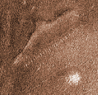
Ark van Noah op Mars?
Als één persoon lijdt aan waanvoorstellingen heet het krankzinnigheid, als er meer mensen aan lijden is het een godsdienst.

Het was een onderzeeër!quote:Op woensdag 15 maart 2006 20:15 schreef andromeda1968 het volgende:
Ark van Noah op Mars?
[afbeelding]
'Nuff said
NiIet rellerig nee Vind ik...De schrijvers hadden juist in gedachten om bewijzen vóór de verhalen te vinden en kwamen er achter dat dat niet zo gemakkelijk ging. .Al denk ik dat Christenen en Joden niet zo blij zullen zijn met dit boek.quote:Op woensdag 15 maart 2006 18:39 schreef MrBean het volgende:
[..]
Is het een beetje een objectief boek? Niet te rellerig?
[ Bericht 3% gewijzigd door ee-04 op 15-03-2006 22:04:34 ]
- God's only excuse is the fact that He doesn't exist -
Ik ben een overtuigd idee aanhanger geworden door het geniale verschijnsel om een boot op 5000 meter hoogte te laten verstenen.quote:
Kein gewalt! Wir sind das volk!
Steps taken forwards but sleepwalking back again.
''And the Germans kill the Jews, And the Jews kill the Arabs, And the Arabs kill the hostages
And that is the news.''
Steps taken forwards but sleepwalking back again.
''And the Germans kill the Jews, And the Jews kill the Arabs, And the Arabs kill the hostages
And that is the news.''
Wat een sukkels zeg. Zitten ze gewoon op de verkeerde berg te zoeken. De Koran zegt toch duidelijk, dat de ark op de berg Cudi is geland
Ik heb Hem niet uit vrees voor de hel noch uit liefde voor het paradijs gediend, want dan zou ik als de slechte huurling zijn geweest; ik heb hem veeleer gediend in liefde tot Hem en in verlangen naar Hem.
-Rabia Al-Basri
-Rabia Al-Basri
en welke berg is dat?quote:Op woensdag 15 maart 2006 21:59 schreef Slayage het volgende:
Wat een sukkels zeg. Zitten ze gewoon op de verkeerde berg te zoeken. De Koran zegt toch duidelijk, dat de ark op de berg Cudi is geland
Dit kan de ark van Noach niet zijn want die heeft nooit bestaan, deze was ook niet nodig want er is nooit een zondvloed geweest.
Dit verhaal sluit mooi aan bij het gezicht van Mars, komen er ooit duidelijke beelden dan is te zien dat het weer eens een gewone rotsformatie is.
Dit verhaal sluit mooi aan bij het gezicht van Mars, komen er ooit duidelijke beelden dan is te zien dat het weer eens een gewone rotsformatie is.

Ik zie er een kledinghanger in .quote:Op woensdag 15 maart 2006 20:15 schreef andromeda1968 het volgende:
Ark van Noah op Mars?
[afbeelding]
Ik zie er een instapschoen inquote:Op woensdag 15 maart 2006 20:15 schreef andromeda1968 het volgende:
Ark van Noah op Mars?
[afbeelding]
Nu met gitaar!
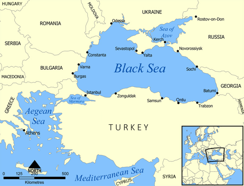
Effe kijken wat WIKI te zeggen heeft:
Tot het 6e millennium v. Chr. was de Zwarte Zee een zoetwatermeer, dat nog niet in verbinding stond met de (zoute) Middellandse Zee (Ballard, 2001). Onderzoekers denken dat toentertijd het water ongeveer 155 m lager stond dan nu, waardoor het meer een ongeveer 150000 km² kleiner oppervlak had. De huidige Zee van Azov was bijvoorbeeld land. Een wereldwijde stijging van het zeeniveau veroorzaakte rond 5200 een abrupte doorbraak (de huidige Bosporus). Eerder onderzoek suggereerde een geleidelijker proces vanaf ongeveer 7050.
http://nl.wikipedia.org/wiki/Zwarte_Zee
Dus zo vergezocht is de zondvloed niet mensen. Of het de zonvdloed is, is natuurlijk een ander verhaal
Ik heb Hem niet uit vrees voor de hel noch uit liefde voor het paradijs gediend, want dan zou ik als de slechte huurling zijn geweest; ik heb hem veeleer gediend in liefde tot Hem en in verlangen naar Hem.
-Rabia Al-Basri
-Rabia Al-Basri
Ik zie nu dat er meerdere Cudis zijn We schieten er niet zo veel mee op dusquote:
http://www.noahsarksearch.com/cudi.htm
Ik heb Hem niet uit vrees voor de hel noch uit liefde voor het paradijs gediend, want dan zou ik als de slechte huurling zijn geweest; ik heb hem veeleer gediend in liefde tot Hem en in verlangen naar Hem.
-Rabia Al-Basri
-Rabia Al-Basri
En die leefden al voor de bijbelse zondvloed en verdwenen pas nadat ze waren overwonnen door de Babyloniersquote:Op woensdag 15 maart 2006 18:41 schreef MrBean het volgende:
De Sumeriërs hadden al een zondvloedverhaal, incluis ark vol dieren en uitgestuurde vogel.
Monday morning I open a beer and light a cigarr. Put my pen to paper and write I hate you all
de koran heeft het dus niet goed begrepenquote:Op woensdag 15 maart 2006 21:59 schreef Slayage het volgende:
Wat een sukkels zeg. Zitten ze gewoon op de verkeerde berg te zoeken. De Koran zegt toch duidelijk, dat de ark op de berg Cudi is geland
If you wish to be a success in the world, promise everything, deliver nothing.
Nothing is more difficult, and therefore more precious, than to be able to decide.
Victory belongs to the most persevering
Nothing is more difficult, and therefore more precious, than to be able to decide.
Victory belongs to the most persevering
Ga snel je mond spoelen!quote:Op donderdag 16 maart 2006 00:13 schreef teamlead het volgende:
[..]
de koran heeft het dus niet goed begrepen
Ik heb Hem niet uit vrees voor de hel noch uit liefde voor het paradijs gediend, want dan zou ik als de slechte huurling zijn geweest; ik heb hem veeleer gediend in liefde tot Hem en in verlangen naar Hem.
-Rabia Al-Basri
-Rabia Al-Basri
De bijbel is duidelijk hoorquote:
heiden
If you wish to be a success in the world, promise everything, deliver nothing.
Nothing is more difficult, and therefore more precious, than to be able to decide.
Victory belongs to the most persevering
Nothing is more difficult, and therefore more precious, than to be able to decide.
Victory belongs to the most persevering
Archaeological Evidence of the Flood
It is no coincidence that today we run into traces of most of the communities which are said in the Qur'an to have been destroyed. Archaeological evidence yields the fact that the more suddenly a community disappears, the more likely it is that we will come across some of its remnants.
In the case of a civilisation suddenly disappearing, which can happen as a result of a natural disaster, sudden emigration or war, the traces of this civilisation can often be preserved much better. Houses in which people lived and tools they once used in daily life are buried under the earth in a short time. Thus these are preserved for quite long periods untouched by human hand and they yield important evidence of the past when brought into daylight.
This is how a great deal of evidence for Nuh's Flood has been uncovered in our day. Thought to have been occurred around the 3rd millennium BC., the Flood put an end to a whole civilisation in a moment, and later caused a brand new civilisation to be established in its stead. Thus the apparent evidence for the Flood has been preserved for thousands of years so that we may take warning.
Many excavations have been made in investigation of the flood which covered the Mesopotamian plains. In excavations made in the region, in four main cities there are found traces of what must have been a particularly large flood. These cities were the important cities of Mesopotamia: Ur, Erech, Kish and Shuruppak.
The excavations made in these cities reveal that all four of these were subjected to a flood around the 3rd millennium BC.
First let's take a look at the excavations made in the city of Ur. The oldest remains of a civilisation unearthed in the excavations made in the city of Ur, which has been re-named "Tell al Muqqayar" in our day, date back as far as 7000 BC. As one of the sites which has been home to one of the earliest civilisations, the city of Ur has been a region of settlements in which many cultures succeeded each other.
Archaeological findings from the city of Ur show that here civilisation was interrupted after an enormous flood, and that then new civilisations later emerged. R.H. Hall from the British Museum made the first excavations here. Leonard Woolley, who took upon himself to carry on with excavations after Hall, also supervised an excavation organised collectively by the British Museum and the University of Pennsylvania. Excavations conducted by Woolley, which had a huge effect world-wide, lasted from 1922 to 1934.
Sir Woolley's excavations took place in the middle of the desert between Baghdad and the Persian Gulf. The first founders of the city of Ur were a people who had come from North Mesopotamia and called themselves "Ubaidian". Excavations originally began to gather information on these people. Woolley's excavations are described by the German archaeologist Werner Keller as follows;
"The graves of the kings of Ur" - so Woolley, in the exuberance of his delight at discovering them, had dubbed the tombs of Sumerian nobles whose truly regal splendour had been exposed when the spades of the archaeologists attacked a fifty-foot mound south of the temple and found a long row of superimposed graves. The stone vaults were veritable treasure chests, for they were filled with all the costly goblets, wonderfully shaped jugs and vases, bronze tableware, mother of pearl mosaics, lapis lazuli, and silver surrounded these bodies which had mouldered into dust. Harps and lyres rested against the walls. "Almost at once" he wrote later in his diary, "discoveries were made which confirmed our suspicions. Directly under the floor of one of the tombs of the kings we found in a layer of charred wood ash numerous clay tablets, which were covered with characters of a much older type than the inscriptions on the graves. Judging by the nature of the writing, the tablets could be assigned to about 3000 BC. They were therefore two or three centuries earlier than the tombs".
The shafts went deeper and deeper. New strata, with fragments of jars, pots, and bowls, kept appearing. The experts noticed that the pottery remained surprisingly enough unchanged. It looked exactly like that which had been found in the graves of the kings. Therefore, it seemed that for centuries the Sumerian civilisation had undergone no radical change. They must, according to the conclusion, have reached a high level of development astonishingly early.
When after several days some of Woolley's workmen called out to him, "We are on ground level", he let himself down onto the floor of the shaft to satisfy himself. Woolley's first thought was "This is it at last". It was sand, pure sand of a kind that could only have been deposited by water.
They decided to dig on and make the shaft deeper. Deeper and deeper went the spades into the ground: three feet, six feet - still pure mud. Suddenly, at ten feet, the layer of mud stopped as abruptly as it had started. Under this clay deposit of almost ten feet thick, they had struck fresh evidence of human habitation. The appearance and quality of the pottery had noticeably altered. Here, they were handmade. Metal remains were nowhere to be found. The primitive implement that did emerge was made of hewn flint. It must belong to the Stone Age!
The Flood - that was the only possible explanation of this great clay deposit beneath the hill at Ur, which quite clearly separated two epochs of settlement. The sea had left its unmistakable traces in the shape of remains of little marine organisms embedded in the mud. 1
According to archaeological finds, Nuh's Flood took place on the Mesopotamian plains. The plains had a different shape then. In the above diagram, the current borders of the plains are denoted with a red cut line. The large section lying be hind the red line is known to have been a part of the sea at that time.
Microscopic analysis revealed that this great clay deposit beneath the hill at Ur had accumulated here as a result of a flood so big as to annihilate ancient Sumerian civilisation. The epic of Gilgamesh and the story of Nuh were united in this shaft dug deep under the Mesopotamian desert.
Max Mallowan related the thoughts of Leonard Woolley, who said that such a huge mass of alluvium formed in a single time slice could only be the result of a huge flood disaster. Woolley also described the flood layer that separated the Sumerian city of Ur from the city of Al-Ubaid whose inhabitants used painted pottery, as the remains of the Flood.2 These show that the city of Ur was one of the places affected by the Flood. Werner Keller expressed the importance of the aforementioned excavation by saying that the yield of city-remains beneath a muddy layer in the archaeological excavations made in Mesopotamia proves that there was a flood here.3
Another Mesopotamian city carrying traces of the Flood is "Kish of the Sumerians" which is now known as Tall Al-Uhaimer. According to ancient Sumerian sources, this city was the "seat of the first postdiluvian dynasty"4
The city of Shuruppak in South Mesopotamia, which is today named as Tall Fa'rah, likewise carries apparent traces of the Flood. Archaeological studies in this city were headed by Erich Schmidt from the University of Pennsylvania between 1920-1930. These excavations uncovered three layers of habitation extending in time from the late prehistoric period to the 3rd dynasty of Ur (2112-2004 BC). The most distinctive finds were ruins of well-built houses along with cuneiform tablets of administrative records and lists of words, indicating a highly developed society already in being toward the end of the 4th millennium BC. 5
Die The excavations made by Sir Leonard Woolley in the Mesopotamian plains disclosed the presence of a mud-clay layer 2.5 m. deep in the earth. This mud-clay layer was most probably formed by the clay masses carried by the flood waters and, in the whole world, it only exists under the Mesopotamian plains. This discovery became an important piece of evidence proving that the Flood had only occurred on the Mesopotamian plains.
The main point is that a big flood disaster was understood to have occurred in this city around 2900-3000 BC. According to Mallowan's account, 4-5 metres below the earth, Schmidt had reached a yellow soil layer (formed by flood) made up of a mixture of clay and sand. This layer was closer to the plain level than the tumulus profile and it could be observed all around the tumulus� Schmidt defined this layer made up of a mixture of clay and sand, which remained from the time of Ancient Kingdom of Cemdet Nasr, as "a sand with its origins in the river" and associated it with Nuh's Flood.6
In the excavations made in the city of Shuruppak, the remains of a flood were found that corresponded approximately to the years 2900-3000 BC. Probably, the city of Shuruppak was probably as much effected by the flood as the other cities.7
The latest place which is shown to have been affected by the Flood is the city of Erech to the south of Shuruppak which is known as Tall Al-Warka today. In this city just as in others, a flood layer is found. This flood layer is dated between 2900-3000 BC just like the others. 8
As is well known, the Tigris and Euphrates rivers cut across Mesopotamia from one end to the other. It seems that, during the event, these two rivers and many other water resources, big and small, overflowed and, by uniting with rain water, caused a big deluge. The event is described in the Qur'an;
So We opened the gates of heaven, with water pouring forth. And We caused the earth to gush forth with springs, so the waters met (and rose) to the extent decreed. (Surat al-Qamar: 11-12)
When the factors causing the Flood are examined one by one, it is seen that they are all very natural phenomena. What makes the event miraculous is their taking place at the same time and Nuh's warning his people about such a disaster beforehand.
Assessment of the evidence obtained from the completed studies revealed that the Flood area stretches approximately 160 km. (in width) from east to west, and 600 km. (in length) from north to south. This shows that the Flood covered all the Mesopotamian plains. When we examine the order of the cities Ur, Erech, Shuruppak and Kish which bear the traces of the Flood, we see that these are lined along a route. Therefore, the Flood must have affected these four cities and their surroundings. Besides it should be noted that around 3000 BC, the geographical structure of the Mesopotamian plain was different from what it is now. At those times, the bed of the Euphrates river was more to the east than it is today; this stream-line was matched with a line passing through Ur, Erech, Shuruppak and Kish. With the opening of the "springs of the earth and heaven", it seems that the river Euphrates overflowed and spread thus destroying the four cities cited above.
NOTES
1. Werner Keller, Und die Bibel hat doch recht (The Bible as History; a Confirmation of the Book of Books), New York: William Morrow, 1964, pp. 25-29
2. Max Mallowan, Nuh's Flood Reconsidered, Iraq:XXVI-2, 1964, p. 70
3. Werner Keller, Und die Bibel hat doch recht (The Bible as History; a Confirmation of the Book of Books), New York: William Morrow, 1964, pp. 23-32
4. "Kish", Britannica Micropaedia, Volume 6, p. 893
5."Shuruppak", Britannica Micropaedia, Volume 10, p. 772
6 Max Mallowan, Early Dynastic Period in Mesapotamia, Cambridge Ancient History 1-2, Cambridge: 1971, p. 238
7 Joseph Campbell, Eastern Mythology, p. 129
8 Bilim ve Utopya, July 1996, 176. Footnote p. 19
quote:Op donderdag 16 maart 2006 00:29 schreef teamlead het volgende:
[..]
De bijbel is duidelijk hoor
heiden
Ik heb Hem niet uit vrees voor de hel noch uit liefde voor het paradijs gediend, want dan zou ik als de slechte huurling zijn geweest; ik heb hem veeleer gediend in liefde tot Hem en in verlangen naar Hem.
-Rabia Al-Basri
-Rabia Al-Basri
Laat ik maar weer eens de aandacht op Santorini vestigen.
In de Minoïsche tijd heeft zich een enorme uitbarsting voorgedaan; volgens dendrochronologisch onderzoek heeft deze in de 1628 v. Chr. plaatsgevonden. Deze braakte zoveel lava uit dat de oude stad Akrotiri onder 50 meter puimsteen verdween. De vulkaan zakte toen ook in de zee en veroorzaakte een tsunami die een enorme verwoesting op Kreta moet hebben veroorzaakt; waarschijnlijk is deze de oorzaak geweest van het tenondergaan van de Minoïsche beschaving.
Santorini is een eiland tussen Kreta en Griekenland.
Met de wetenschap dat de omwonenden van de Middellandse zee in het verleden een verwoestende tsunami hebben meegemaakt, hoe onwaarschijnlijk is het eigenlijk dat verhalen als Atlantis, het vernietigen van het Egyptische leger door golven (mozes, rietzee) en de zondvloed hierdoor zijn geinspireerd?
Wie gelooft in God gelooft niet in al die andere 19.999 goden.
Ik geloof niet in 20.000 goden. Zo'n klein verschil maar zoveel discussie.
Ik geloof niet in 20.000 goden. Zo'n klein verschil maar zoveel discussie.
niet onwaarschijnlijkquote:Op donderdag 16 maart 2006 00:48 schreef onemangang het volgende:
Laat ik maar weer eens de aandacht op Santorini vestigen.
[afbeelding]
In de Minoïsche tijd heeft zich een enorme uitbarsting voorgedaan; volgens dendrochronologisch onderzoek heeft deze in de 1628 v. Chr. plaatsgevonden. Deze braakte zoveel lava uit dat de oude stad Akrotiri onder 50 meter puimsteen verdween. De vulkaan zakte toen ook in de zee en veroorzaakte een tsunami die een enorme verwoesting op Kreta moet hebben veroorzaakt; waarschijnlijk is deze de oorzaak geweest van het tenondergaan van de Minoïsche beschaving.
Santorini is een eiland tussen Kreta en Griekenland.
Met de wetenschap dat de omwonenden van de Middellandse zee in het verleden een verwoestende tsunami hebben meegemaakt, hoe onwaarschijnlijk is het eigenlijk dat verhalen als Atlantis, het vernietigen van het Egyptische leger door golven (mozes, rietzee) en de zondvloed hierdoor zijn geinspireerd?
Wat onwaarschijnlijker is, is dat de verhalen in Afrika en Zui-Amerika over zondvloed etc hierdoor geinspireerd zijn
If you wish to be a success in the world, promise everything, deliver nothing.
Nothing is more difficult, and therefore more precious, than to be able to decide.
Victory belongs to the most persevering
Nothing is more difficult, and therefore more precious, than to be able to decide.
Victory belongs to the most persevering
Dit wijst inderdaad op een lokale vloed, maar niet over een wereldwijde vloed die al het leven vernietigde. Heeft de Koran het trouwens over een 'vloed' of net als in de Bijbel over de zondvloed die al het leven vernietigde?quote:Op donderdag 16 maart 2006 00:30 schreef Triggershot het volgende:
Archaeological Evidence of the Flood
...
lang verhaal
Indien het laatste het geval is, hoe kun je dan verklaren dat de Chinezen bijvoorbeeld helemaal nergens last van hadden. Hun beschaving ontwikkelde zich gewoon voor, tijdens en na de vloed en in al hun geschriften wordt geen melding gemaakt dat het water eventjes een paar kilometer hoog stond.
Nu met gitaar!
China heeft een aantal grote rivieren die regelmatig overstromen. Waarom zouden zij niet volgens het zelfde principe (grote watersnoodramp wordt mond op mond uitgebouwd tot goddelijke legende) hun eigen zondvloedverhaal creëren?quote:Op donderdag 16 maart 2006 09:34 schreef Funkytrip het volgende:
[..]
Dit wijst inderdaad op een lokale vloed, maar niet over een wereldwijde vloed die al het leven vernietigde. Heeft de Koran het trouwens over een 'vloed' of net als in de Bijbel over de zondvloed die al het leven vernietigde?
Indien het laatste het geval is, hoe kun je dan verklaren dat de Chinezen bijvoorbeeld helemaal nergens last van hadden. Hun beschaving ontwikkelde zich gewoon voor, tijdens en na de vloed en in al hun geschriften wordt geen melding gemaakt dat het water eventjes een paar kilometer hoog stond.
Non possumus non loqui
Volgens mij schreef Funkytrip juist dat er geen Chinees zondvloed verhaal is, iets wat vreemd is als heel de wereld blank stond. De Chinese cultuur heeft dan dus de Chisten/Islamitische zondvloed overleeft zonder er last van te hebben.quote:Op donderdag 16 maart 2006 10:08 schreef Knip het volgende:
[..]
China heeft een aantal grote rivieren die regelmatig overstromen. Waarom zouden zij niet volgens het zelfde principe (grote watersnoodramp wordt mond op mond uitgebouwd tot goddelijke legende) hun eigen zondvloedverhaal creëren?
Now I'm walking on the sunnyside of the street
Of er een chinees verhaal is, weet ik niet... ik weet wel dat er een aantal verhalen over een zondvloed bestaan:quote:Op donderdag 16 maart 2006 10:19 schreef Invictus_ het volgende:
[..]
Volgens mij schreef Funkytrip juist dat er geen Chinees zondvloed verhaal is, iets wat vreemd is als heel de wereld blank stond. De Chinese cultuur heeft dan dus de Chisten/Islamitische zondvloed overleeft zonder er last van te hebben.
Dat zijn toch flink wat verhalen met dezelfde strekking. En nee, het zullen niet de meest accurate ooggetuigeverslagen zijn... Maar een gelijkluidend verhaal in zoveel verschillende culturen die zover uit elkaar leven zondermeer aan de kant schuiven omdat er in China geen document is gevonden is wat makkelijk natuurlijk
If you wish to be a success in the world, promise everything, deliver nothing.
Nothing is more difficult, and therefore more precious, than to be able to decide.
Victory belongs to the most persevering
Nothing is more difficult, and therefore more precious, than to be able to decide.
Victory belongs to the most persevering
Ook in china bestaat een vergelijkbaar verhaal blijkbaar:
Ik ga eens googlen om te kijken of ik deze bewering ook nog ergens op een wat betrouwbaar ogende site kan vinden
bronquote:In de meeste wereldmythes komt een soortgelijk relaas voor, en het centrale thema is altijd opmerkelijk eenduidig: een rampzalige overstroming waarbij het hele mensdom, behalve een enkele overlevende en (soms) zijn familie, ten onder gaat. Bij de Azteken heette die overlevende Nene; in een vroege Vedische tekst uit India verschijnt hij als Manu, en in China staat hij bekend als Fo-Hsi. En in oude Midden-Oosterse teksten (eerder ontstaan dan de bijbel) komen niet minder dan drie zondvloedhelden voor: Astra-Hasis, Utnapisjtim en Ziusudra.
Ik ga eens googlen om te kijken of ik deze bewering ook nog ergens op een wat betrouwbaar ogende site kan vinden
If you wish to be a success in the world, promise everything, deliver nothing.
Nothing is more difficult, and therefore more precious, than to be able to decide.
Victory belongs to the most persevering
Nothing is more difficult, and therefore more precious, than to be able to decide.
Victory belongs to the most persevering
kei-interessant dit allemaal. Op zulke momenten wou ik wel dat ik Geschiedenis studeer.
Vooral het feit dat het verhaal op verschillende werelddelen terug komt is natuurlijk erg opvallend. Hoewel het natuurlijk ook op toeval kan berusten. Ik denk dat veel beschavingen aan de kust floreerden en welke kust krijgt nu niet eens in de honderden jaren een enorme overstroming te verwerken. Dat plus het feit dat ik me kan voorstellen dat veel beschavingen verhalen/mythen en godsdiensten van elkaar overnamen, maakt het weer wat aannemelijker dat een paar flinke overstromingen/tsunami's in veel verhalen terug komt.
Vooral het feit dat het verhaal op verschillende werelddelen terug komt is natuurlijk erg opvallend. Hoewel het natuurlijk ook op toeval kan berusten. Ik denk dat veel beschavingen aan de kust floreerden en welke kust krijgt nu niet eens in de honderden jaren een enorme overstroming te verwerken. Dat plus het feit dat ik me kan voorstellen dat veel beschavingen verhalen/mythen en godsdiensten van elkaar overnamen, maakt het weer wat aannemelijker dat een paar flinke overstromingen/tsunami's in veel verhalen terug komt.
Je mist de nuance; het verhaal van China kwam naar boven als probleem als de zondvloed word uitgelegd als 'Gods Grote Reset', het ark verhaal in zijn extreemste vorm dwz totale aarde onder water.quote:Op donderdag 16 maart 2006 10:33 schreef teamlead het volgende:
[..]
Dat zijn toch flink wat verhalen met dezelfde strekking. En nee, het zullen niet de meest accurate ooggetuigeverslagen zijn... Maar een gelijkluidend verhaal in zoveel verschillende culturen die zover uit elkaar leven zondermeer aan de kant schuiven omdat er in China geen document is gevonden is wat makkelijk natuurlijk
Maar zoals je zelf al laat zien, het christelijke verhaal is gewoon een van de vele. Ieder clubje heeft een eigen verhaal over een lokale watersnoodramp die ze zien als een globale vloed.
Now I'm walking on the sunnyside of the street
Het zou in ieder geval interessant zijn als al deze mythen zich in een periode van zeg 500 jaar ofzo afspeelden. Ik denk dat dit echter niet het geval is. Zou een leuk onderzoekje zijn.quote:Op donderdag 16 maart 2006 11:15 schreef Invictus_ het volgende:
[..]
Je mist de nuance; het verhaal van China kwam naar boven als probleem als de zondvloed word uitgelegd als 'Gods Grote Reset', het ark verhaal in zijn extreemste vorm dwz totale aarde onder water.
Maar zoals je zelf al laat zien, het christelijke verhaal is gewoon een van de vele. Ieder clubje heeft een eigen verhaal over een lokale watersnoodramp die ze zien als een globale vloed.
Nu met gitaar!
Ik ben geen historicus, maar is ooit onderzocht of die verhalen uit dezelfde tijd komen? Misschien is er wel sprake geweest van een wereldwijde ramp. Jouw stelling dat het allemaal locale overstromingen zijn die op dezelfde manier worden onthouden lijkt me persoonlijk wat stug. De overeenkomsten zijn daarvoor simpelweg te grootquote:Op donderdag 16 maart 2006 11:15 schreef Invictus_ het volgende:
[..]
Je mist de nuance; het verhaal van China kwam naar boven als probleem als de zondvloed word uitgelegd als 'Gods Grote Reset', het ark verhaal in zijn extreemste vorm dwz totale aarde onder water.
Maar zoals je zelf al laat zien, het christelijke verhaal is gewoon een van de vele. Ieder clubje heeft een eigen verhaal over een lokale watersnoodramp die ze zien als een globale vloed.
If you wish to be a success in the world, promise everything, deliver nothing.
Nothing is more difficult, and therefore more precious, than to be able to decide.
Victory belongs to the most persevering
Nothing is more difficult, and therefore more precious, than to be able to decide.
Victory belongs to the most persevering
|
|