WKN Weer, Klimaat en Natuurrampen
Lees alles over het onstuimige weer op onze planeet, volg orkanen en tornado's, zie hoe vulkanen uitbarsten en hoe Moeder Aarde beeft bij een aardbeving. Alles over de verwoestende kracht van onze planeet en tal van andere natuurverschijnselen.


informatie:
http://en.vedur.is/earthquakes-and-volcanism/earthquakes/
http://nl.wikipedia.org/wiki/Gr%C3%ADmsv%C3%B6tn
http://www.jonfr.com/volcano/
http://www.barthokriek.nl/ondertiteling/lijsten/vulkanologie.htm
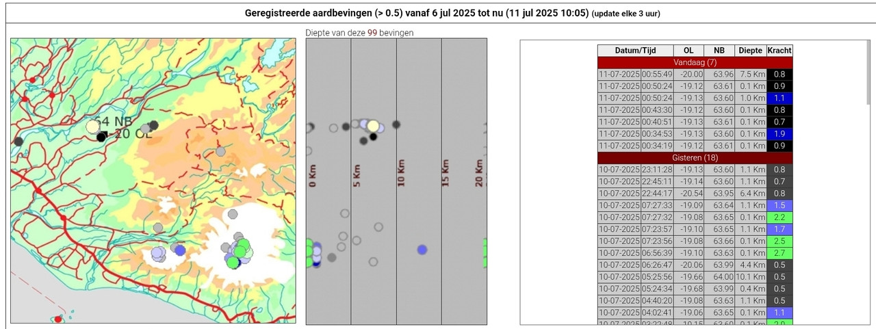
Metingen & Bevingen
Aardbevingen IJsland
http://hraun.vedur.is/ja/vatnajokulsvoktun/grf_trem.html
http://hraun.vedur.is/ja/englishweb/tremor.html
Metingsoverzicht per gebied
Waar zitten de bevingen - 3D view
De verzakking van de Bardarbunga caldera
Bevingen over het eiland heen
Meeste meet gegevens die hier boven staan op 1 pagina verzameld
Interactief kaartje met o.a. bevingen. (druk op de knop layers en kies earthquakes)
3D Aardbevingsmap
Live Aardbevingsmap

Nieuws:
http://www.ijsland-enzo.nl/index.asp
http://www.icenews.is/
http://icelandreview.com/
http://www.luchtvaartnieuws.nl/
https://www.ruv.is/fretti(...)a-gasmaelinga-396985

Webcams:
http://www.livefromiceland.is/webcams/bardarbunga/
http://www.livefromiceland.is/webcams/bardarbunga-2/
https://www.ruv.is/frett/(...)svaedinu-borgarfjall
https://www.visir.is/g/20(...)-i-beinni-utsendingu
https://www.vf.is/frettir/keilir-i-beinni-utsendingu-vikurfretta


Relevante en wellicht interessante topics:
WKN / Adembenemend Noorderlicht #3
WKN / [Vulkanen] The Ring of Fire #8: Het rommelt en borrelt
WKN / Aardbevingen #22
28 aug 2024:


quote:Sulfur dioxide emissions from volcanic eruption in Iceland reach Europe
Sulfur dioxide (SO2) emissions produced by the new eruption in Reykjanes Peninsula, Iceland have reached Europe. The forecast and measured SO2 concentrations are currently below the recommended exposure threshold with no major impact on air quality and health.
This year’s sixth eruption in Reykjanes Peninsula began on August 22, producing significant SO2 emissions that crossed the North Atlantic and reached NW Europe on August 24, before moving further east.
According to Copernicus Atmosphere Monitoring Service (CAMS), satellite observations of the plume height indicate that the highest concentration is between 5 – 8 km (3 – 5 miles) in the atmosphere, but forecasts and surface measurement sites have also shown some increased concentrations of SO2 (up to 20 μg/m³) at ground level.
The forecasted and measured SO2 concentrations are below the recommended exposure threshold of 350 μg/m³ set by EU air quality standards and are not expected to have significant impacts on air quality or health.
“The Reykjanes Peninsula has been experiencing increased volcanic activity and eruptions, resulting in large plumes of sulfur dioxide in the atmosphere,” said CAMS Senior Scientist Mark Parrington.
“In CAMS, near-real-time satellite observations of the plumes allow us to track the SO2 in the atmosphere and analyze the possible impacts on air quality. The emissions from this episode have not been severe enough to significantly impact global atmospheric processes or human health, but documenting and monitoring each episode is important.”
According to the Icelandic Met Office (IMO) report issued on August 26, all data suggest that this eruption is the largest in the area since the unrest period began in the autumn of 2023.


Het lijkt minder maar intussen hebben we daar wel een vulkaan staan die in een 10 dagen is gevormd .. geen idee hoe hoog , maar er was niets in den beginne
Highlights Isak gisteren ...
Later vloog ie ook nog voor Geoloog Shawn Willsey die de boel daar bestudeert en zelf Geologie lessen op YT zet

Later vloog ie ook nog voor Geoloog Shawn Willsey die de boel daar bestudeert en zelf Geologie lessen op YT zet


Dan ben je toch echt goed gestoord.quote:Op donderdag 5 september 2024 19:51 schreef chufi het volgende:
Het einde van de uitbarsting lijkt in zicht ..
Hadden we deze al gezien?
Hij zakt er nog doorheen ook

Wat een teringdebiel......quote:
Het einde van de uitbarsting lijkt in zicht ..
Hadden we deze al gezien?

quote:False alarm as volcano prepares to rumble
In the early morning of November 4, a series of earthquakes were recorded between Stóra Skógfell and Sýlingarfell on the Reykjanes Peninsula. The Met Office’s alert responses were partially activated due to a possible magma intrusion. Most of the activity blew over in 30 minutes, after which the Met Office concluded there was no cause for concern, RÚV reports.
In conversation with Vísir, the Met Office’s natural disaster specialist Salóme Jórunn Bernharðsdóttir claimed area’s magma levels were not sufficient enough to start an eruption. However, they are growing closer to the limit.
On October 29, the Met Office published their estimation for an upcoming volcanic event. The office reported that a new eruption might be expected in Svartsengi at the end of November, due to the steadily growing levels and pace of ground uplift and pooling magma in the area
Bekijk deze YouTube-video
Lekker streampje van afgelopen nacht terugkijken met een dekentje of wat je ook wil met dit koude weer
Lekker streampje van afgelopen nacht terugkijken met een dekentje of wat je ook wil met dit koude weer
Als het niet met een hamer te repareren is, is het een elektrisch probleem.

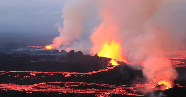
Het is een flinke uitbarsting deze keer zo te zien. Zal ie wel sneller weer uitdoven
No I don't want fiber in my soda. I don't want protein in my waffles. Stop adding random shit to perfectly good food.
Toch weer verrassend.
Kleinere uitbarsting dan in augustus. Kan een paar dagen duren, maar ook weer weken.
Kleinere uitbarsting dan in augustus. Kan een paar dagen duren, maar ook weer weken.
Alleen in de menigte, een mes in mijn hand. Het bloed stroomt, ontsnapt uit diepe wonden, geslagen door het leven zelf.
Het leven eindigt wanneer de dood zijn werk heeft voltooid.
Het leven eindigt wanneer de dood zijn werk heeft voltooid.
Het dorpje in het noorden zou er in de toekomst ook mee te maken kunnen krijgen. 1500 inwoners.
Alleen in de menigte, een mes in mijn hand. Het bloed stroomt, ontsnapt uit diepe wonden, geslagen door het leven zelf.
Het leven eindigt wanneer de dood zijn werk heeft voltooid.
Het leven eindigt wanneer de dood zijn werk heeft voltooid.
Over 4 uur gaat Isak weer live met zijn drone.
Bekijk deze YouTube-video
Bekijk deze YouTube-video
My age is very
Inappropriate
for my behavior
Inappropriate
for my behavior
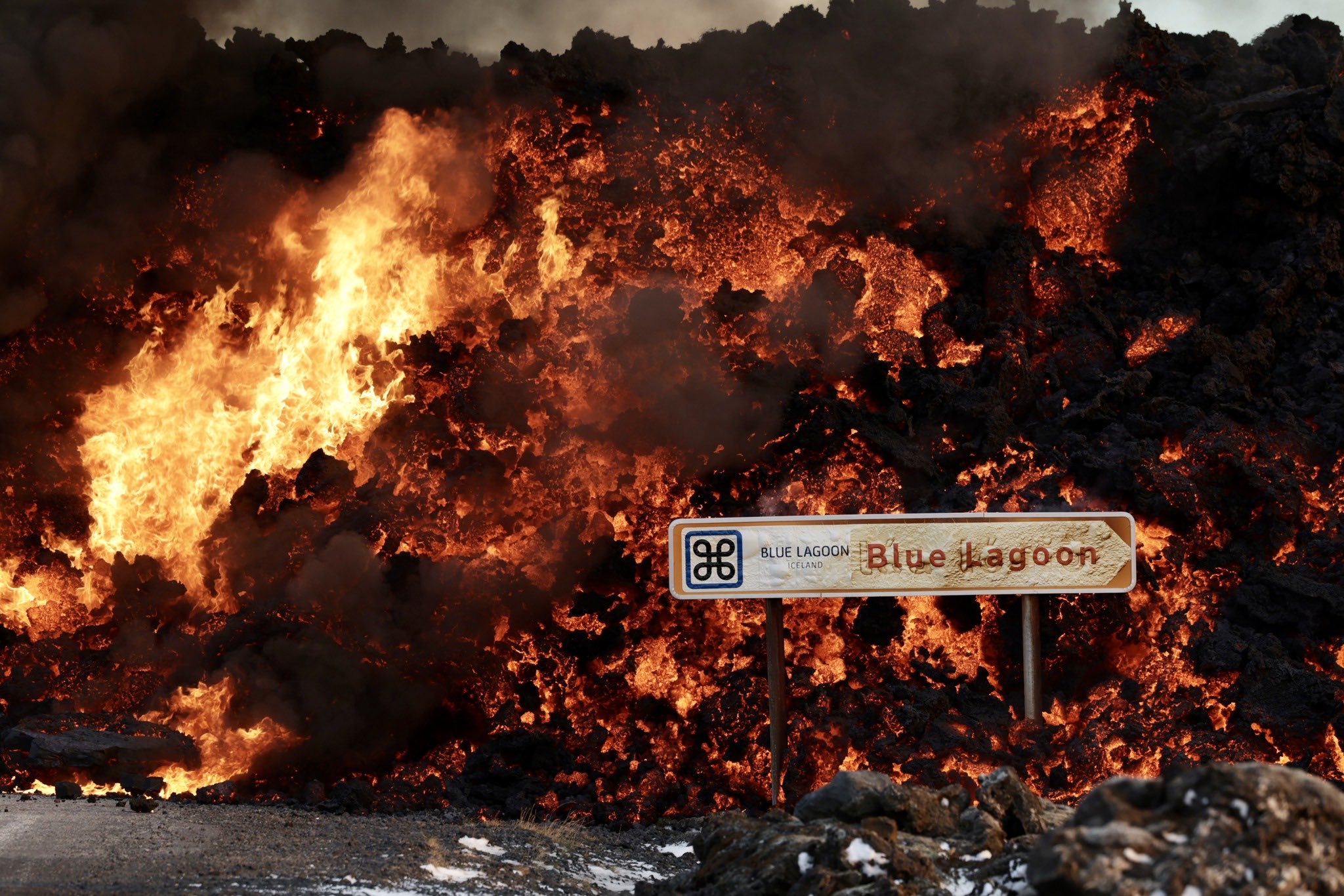
Blue Lagoon zelf niet in gevaar zo?quote:Op donderdag 21 november 2024 15:22 schreef Frutsel het volgende:
Blue Lagoon parkeerplaats gaat eraan...
[ x ]
Nog niet maar ja... zag net ook al een bericht dat de snelheid van deze voortstuwende lava anders was dan vorige kerenquote:
[..]
Blue Lagoon zelf niet in gevaar zo?
Alleen in de menigte, een mes in mijn hand. Het bloed stroomt, ontsnapt uit diepe wonden, geslagen door het leven zelf.
Het leven eindigt wanneer de dood zijn werk heeft voltooid.
Het leven eindigt wanneer de dood zijn werk heeft voltooid.
Zonder die dijk was er nu geen Blue Lagoon meer geweest denk ik.
Alleen in de menigte, een mes in mijn hand. Het bloed stroomt, ontsnapt uit diepe wonden, geslagen door het leven zelf.
Het leven eindigt wanneer de dood zijn werk heeft voltooid.
Het leven eindigt wanneer de dood zijn werk heeft voltooid.
De weg is weg idd.
Alleen in de menigte, een mes in mijn hand. Het bloed stroomt, ontsnapt uit diepe wonden, geslagen door het leven zelf.
Het leven eindigt wanneer de dood zijn werk heeft voltooid.
Het leven eindigt wanneer de dood zijn werk heeft voltooid.

Eerst gaat ie zn verloren drone zoeken..
Daarvoor een drone vlucht met geoloog Shawn Willsey om 14:45
Bekijk deze YouTube-video
Daarvoor een drone vlucht met geoloog Shawn Willsey om 14:45
Bekijk deze YouTube-video
Ik zet hem net aan...
Alleen in de menigte, een mes in mijn hand. Het bloed stroomt, ontsnapt uit diepe wonden, geslagen door het leven zelf.
Het leven eindigt wanneer de dood zijn werk heeft voltooid.
Het leven eindigt wanneer de dood zijn werk heeft voltooid.
Is nog één live trouwens, maar die is slecht te verstaan.
Alleen in de menigte, een mes in mijn hand. Het bloed stroomt, ontsnapt uit diepe wonden, geslagen door het leven zelf.
Het leven eindigt wanneer de dood zijn werk heeft voltooid.
Het leven eindigt wanneer de dood zijn werk heeft voltooid.
Ja AfarTV zag al in de planning staanquote:Op zaterdag 23 november 2024 18:18 schreef 444 het volgende:
Is nog één live trouwens, maar die is slecht te verstaan.
Bekijk deze YouTube-video
quote:Volcanic pollution rising as eruption continues at Reykjanes Peninsula, Iceland
The levels of sulfur dioxide (SO2) are rising in the vicinity of Grindavik due to the ongoing volcanic eruption on the Reykjanes Peninsula, Iceland. The gas pollution has reached unhealthy levels, as reported by the Icelandic Meteorological Office (IMO).
Volcanic activity near Grindavik has not decreased as quickly as it did in previous eruptions, IMO reported at 15:45 UTC on November 25, 2024.
“Since yesterday in the early evening [LT], volcanic tremor and visible activity from the eruption have further diminished, but the activity stabilized again after midnight. Nevertheless, the eruption remains quite powerful, and the activity has not decreased as quickly as it had in previous eruptions in the Sundhnúkur crater row. For comparison, the current lava flow is estimated to be on par with the most vigorous eruptions at Fagradalsfjall,” IMO volcanologists said.
Volcanic activity remains strong with the lava volume estimated at 43 million m3 (0.010 mi3), as of Saturday, November 23 — three days into the eruption. It covered an area of about 8.5 km2 (3.28 mi2), which is around 65% of the amount produced in the last eruption which lasted 14 days.
Land continues to subside in Svartsengi, though at a slower rate compared to what was observed at the start of the eruption.
“It is still too early to determine whether magma accumulation will persist under Svartsengi. The flow of lava from eruptive vents needs to decrease further before any conclusions can be made about continued magma accumulation,” IMO said.
Today, wind directions are shifting and becoming variable, meaning volcanic pollution could spread to the surrounding areas in the southwestern part of the country.
Authorities deployed 12 water cannons, to stop the advancing lava flows, on the L3 defense wall on November 24. These were being used to cool a 360 m (1 181 feet) section of lava that threatens the Svartsengu geothermal facility and the Njarðvikuraeð hot water pipeline which are crucial for the Suðurnes region.
The initial testing of the cooling process was successful and operations have begun with 6 eastern cannons. The remaining units are scheduled to follow with the process expected to take several days.
quote:Steady eruption near Grindavík, Iceland
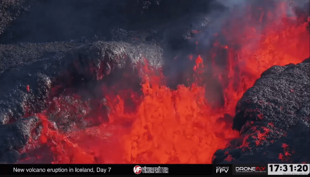
Eruptive activity near Grindavik, Iceland, remains steady on November 28, 2024, with the eruption continuing from a single vent and lava flowing east and southeast. Gas pollution caused by northeast winds at 35 – 55 km/h (20 – 35 mph) was moving toward Grindavík today and was forecast to spread to nearby areas as the weather patterns change.
The fissure opening around midnight taken from the Coast Guard helicopter. Lights in the town of Grindavík seen in the distance on November 28, 2024. Image credit: Civil Protection/Björn Oddsson
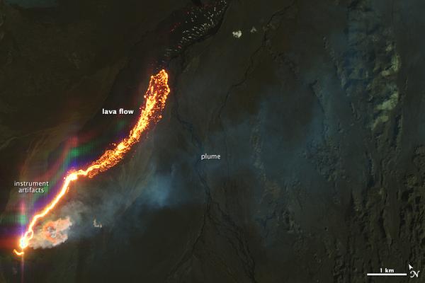
Eruptive activity near Grindavik has been steady over the last 24 hours, with lava now flowing predominantly east and southeast, towards and along the base of Fagradalsfjall, the Icelandic Met Office (IMO) reported at 15:50 UTC on November 28.
The lava field near Fagradalsfjall has expanded slightly but continues to thicken.
Volcanic tremor has remained stable alongside eruptive activity in the vent while the rate of subsidence around Svartsengi has significantly reduced.
However, because daily changes are minor, the trend of deformation measurements must be monitored over the next several days to determine whether the uplift has resumed.
Reykjanes Peninsula, Iceland molten lava approaches infrastructure on November 21, 2024
Molten lava approaches infrastructure, Reykjanes Peninsula, Iceland on November 21, 2024. Image credit: IMO
The eruption site has been limited to a single active vent of Stóra-Skógfell with lava flowing eastward. Flows beneath the solid crust have been found near the protective wells at Svartsengi and the Blue Lagoon geothermal spa.
The eruption tremors have stabilized and the ground subsidence around Svartsengi has slowed down on November 28.
On November 27, IMO issued an updated hazard assessment, valid until 15:00 on November 29, assuming no significant changes. Based on the eruption’s development over the past few days and the gas dispersion forecast, the hazard assessment has been revised from the previous version.
The main changes involve Zone 1 (Svartsengi), where the overall hazard level is now assessed as considerable (amber) instead of high (red), and Zone 4 (Grindavík), where the overall hazard level has been downgraded from considerable (amber) to moderate (yellow).
In Zone 1 (Svartsengi), the risk of lava flow and gas pollution remains high, but the risk of tephra fall has been downgraded to moderate from considerable.
For Zone 4 (Grindavík), the only change is that the risk of gas pollution is now assessed as “considerable,” down from “very high.” According to the gas dispersion forecast, there is a likelihood of gas pollution in Grindavík on November 29.
Next eruption could happen in February
Benedikt Ófeigsson, a geophysicist at the Icelandic Meteorological Office, says that ground uplift is continuing at a steady pace under Svartsengi. He expects the next eruption to occur around the end of January or the beginning of February.
https://www.ruv.is/englis(...)n-in-february-431368
Benedikt Ófeigsson, a geophysicist at the Icelandic Meteorological Office, says that ground uplift is continuing at a steady pace under Svartsengi. He expects the next eruption to occur around the end of January or the beginning of February.
https://www.ruv.is/englis(...)n-in-february-431368
v
quote:Earthquake swarm on Reykjanes Ridge, Iceland
A strong earthquake swarm was registered on Iceland’s Reykjanes Ridge between December 28 and 30, 2024. The activity was concentrated in a tectonically active area, with the strongest reaching M3.6.
The Icelandic Met Office (IMO) registered a total of 258 earthquakes on or near Reykjanes Ridge in 48 hours to 20:15 UTC on December 30, 2024, with activity concentrated around Eldey and nearby locations.
Out of the total events, 104 earthquakes had a magnitude below 1. These smaller quakes often go unnoticed by residents but are critical in understanding the ongoing seismic processes in the region.
Another 137 earthquakes registered between magnitude 1 and 2, accounting for the majority of the seismic events.
Fifteen earthquakes were recorded with magnitudes ranging between 2 and 3, which are typically strong enough to be felt locally.
Two earthquakes exceeded magnitude 3, with the strongest quake of magnitude 3.6 occurring at 13:55 UTC on December 29, at a depth of 9.9 km (6.1 miles) and located 3.7 km (2.2 miles) north-northeast of Eldey.
The recent seismic activity is attributed to tectonic movements along the Mid-Atlantic Ridge where the Eurasian and North American tectonic plates diverge.
“They are moderately powerful, with two measuring above magnitude 3 and several others just below that, occurring both early this morning and later in the afternoon,” Böðvar Sveinsson, a natural hazard specialist at the IMO noted.
“This is likely due to tectonic plate movements, but so far, there are no signs of volcanic tremor,” Sveinsson added.
The region is a part of the Reykjanes volcanic system and is known for frequent seismic and volcanic activity because of its location along the Mid-Atlantic Ridge. The system includes numerous postglacial basaltic crater rows and small shield volcanoes.
The Reykjanes volcanic system has a long history of eruptions with 20 confirmed Holocene eruptive periods. Historical records include events as recent as the 13th century with eruptions along NE-SW fissure systems forming new craters and lava flows. Submarine eruptions have also been observed occasionally forming ephemeral islands.
Major eruptions include the Campanian Ignimbrite eruption around 36 000 years ago and the Neapolitan Yellow Tuff eruption 15 000 years ago.


quote:Bardarbunga volcano (Iceland): strong seismic swarm, likely magma intrusion, alert raised
A strong earthquake swarm has started under the volcano this morning at around 6 a.m. local time. More than 100 quakes with magnitudes up to 5.0 have been recorded since. The strongest quake was a 5.0 shock at 08.05 am local time.
The quakes are clustered under the northern part of the large, completely ice-covered Bárðarbunga caldera, and located at depths spanning between 10 km and the surface. This is the strongest seismic activity of the volcano since the preceding seismic activity prior to its massive eruption in 2014-15. The activity closely resembles the pattern of a new magma intrusion, which is likely the cause.
This could (but by no means must) result in a new eruption, even in a very short term. If the eruption starts under the ice shield (where the current intrusion is taking place), it would result in potentially dangerous glacial melt-water floods (known as "jökulhlaups"). It also could lead to significant ash emissions once the erupted lava has melted a hole through the thick ice shield, and allows explosive interaction between magma and water to eject ash into the atmosphere - this in turn would depend on the duration and volume of such eruption.
While it is far from certain what might or might not follow, the aviation alert level of the volcano was raised to yellow and a "Level of Uncertainty" was declared for Bárðarbunga by the Civil Protection. As of the latest information available, activity has slowed during the past few hours.
quote:Glacial outburst flood at Grímsvötn volcano, Iceland
Seismic readings indicated the onset of a glacial outburst flood from Grímsvötn volcano on January 13, 2025. Grímsvatn floods have occurred almost annually since November 2021. There are examples of volcanic eruptions occurring due to pressure relief in Grímsvötn after water gushes from there. However, glacial outburst floods have occurred much more frequently without volcanic eruptions.
A glacial outburst flood began on January 13 at Grímsvötn, one of Iceland’s central and highly active volcanoes situated beneath the Vatnajökull ice sheet.
Seismic activity on Grímsvötn has been rising steadily in recent days which signaled the movement of water beneath the glacier. The floodwaters flow from Grímsvötn through Skeiðarárjökull and enter Gígjukvísl, a glacial river south of the glacier.
The turbulence graph from Grímsfjall shows consistent growth in seismic signals within the 2 to 4 Hz frequency range.
“The Institute of Earth Sciences’ GPS device on the ice shelf in Grímsvötn cannot be contacted, making it more difficult to assess how quickly the water is flowing from the lakes and down the channel under Skeiðarárjökull, but turbulence measurements on Grímsfjall provide indications of the development of the flow,” IMO noted on January 13.
The measurements were combined with hydrological data and indicate that the glacial flood is in its early stages. The current water volume in Grímsvötn is estimated to be approximately 0.25 km3 (0.06 mi3) which is about one-third of the volume recorded before the outburst in 2021.
Past patterns suggest that peak flow rates could occur in the latter half of the week. The maximum water discharge at National Road 1 in Gígjukvísl is projected to reach approximately 1 000 m3/s (35 315 feet3/s).
Experts believe it will not pose a threat to infrastructure such as roads and bridges in the region despite the substantial flow.
Bárðarbunga stiller - voorlopig?
Hoewel de aardbevingszwerm in Bárðarbunga gisteren afnam, kunnen we niet achteroverleunen, zegt geofysicus Freysteinn Sigmundsson.
Hij benadrukt de toenemende druk in het vulkaansysteem Bárðarbunga, in combinatie met de grootste bodemverheffing die ooit in IJsland is waargenomen, volgens berekeningen van Magnús Tumi Guðmundsson.
"Hoewel de aardbevingszwerm nu even is gestopt, is er fundamenteel niets veranderd. We verwachten dat er magma in de wortels van deze vulkaan blijft stromen, daarom moeten we waakzaam blijven", legt Freysteinn uit.
Freysteinn merkt op dat Bárðarbunga waarschijnlijk de locatie is van de meest productieve magmaproductie in IJsland. Zelfs een kleine subglaciale uitbarsting kan aanzienlijke gevolgen hebben, waaronder gletsjeruitbarstingen (jökulhlaup) of zelfs asregens die gebieden in de windrichting treffen
Het meest waarschijnlijke scenario is dat magma ondergronds beweegt vanuit de caldera van Bárðarbunga en zich lateraal verspreidt voordat het de oppervlakte bereikt. Magma-intrusies ( dijken ) kunnen in meerdere richtingen reizen, wat leidt tot een uitbarsting onder de gletsjer of erbuiten.
https://www.ijsland-enzo.nl/ijsland/actueel_nieuwspagina.asp
v
Uit:quote:Magma accumulation approches critical volume at Svartsengi, Iceland
Magma continues accumulating beneath Svartsengi at a rate nearing the levels observed before the previous eruption. Deformation measurements confirm ongoing ground uplift, with geophysical models estimating that the subsurface magma volume is approaching the threshold associated with past magma intrusions.
Deformation measurements indicate sustained ground uplift in the Svartsengi region which is consistent with patterns seen before past eruptions.
Modeling calculations estimate that the magma accumulating beneath the area is nearing the amount drained during the last eruption on December 9, 2024. If this trend continues, the probability of a new magma intrusion and subsequent eruption will rise in the coming weeks.
Scientists analyzing previous events have found that once a similar volume of magma builds up, intrusion events tend to occur, often followed by an eruption.
The overall earthquake count remains relatively low while seismic activity in the Sundhnúkar fissure system has been increasing slowly since December 9, 2024, suggesting that the next eruption might not be preceded by seismic activity.
The updated hazard assessment from the IMO reflects the growing magma volume beneath Svartsengi.
Based on magma inflow rates, experts estimate that the subsurface magma volume could reach 12 million m3 (424 million feet3) by late January and potentially 13.5 million m3 (477 million feet3) by early February.
The estimates align with the amount of magma involved in the intrusion event on November 20, 2024, suggesting that conditions for another magma intrusion are becoming increasingly favorable.
The Icelandic Meteorological Office (IMO) has raised the hazard level in Zones 4 and 6 from moderate (Yellow) to considerable (Orange), and adverse weather conditions in the coming days may impact monitoring capabilities. The updated hazard assessment is valid until February 11 unless developments occur.
WKN / WKN Jaaroverzicht 2024
Kan dus elk moment inderdaad gebeurenquote:Echter volgt op 20 december het bericht dat ook nu de grond in het gebied weer aan het stijgen is en dag magma zich opnieuw beweegt. Men verwacht dan ook dat eind januari of begin februari 2025 er opnieuw een eruptie in het gebied zal plaatsvinden.

Nah, knallen maar weerquote:
[..]
Uit:
WKN / WKN Jaaroverzicht 2024
[..]
Kan dus elk moment inderdaad gebeuren
I've got 99 problems, but a bitch ain't one.
quote:Volcanic eruption risk in Iceland increases, scientists warn
REYKJAVIK, Iceland – Scientists in Iceland say there is an increasing likelihood that a volcano, which has erupted several times since the end of 2023, will spring to life once again as magma continues to build up beneath the Earth’s surface.
The Icelandic Meteorological Office (IMO) said on Friday that the amount of magma accumulating beneath Svartsengi is approaching levels observed during previous eruptions, and the likelihood of a new magma intrusion or eruption is increasing.
Scientists have also been concerned about severe winter weather across the region. According to the IMO, weather could impact monitoring and response in case of a magma intrusion or eruption.
"Strong winds, sleet and snow could interfere with seismic measurements and reduce the accuracy of GPS monitoring of ground lift," the IMO said. "The Icelandic Meteorological Office will continue to closely monitor developments, and people are encouraged to pay attention to weather warnings and exercise caution when traveling."
Scientists say that according to model calculations, magma under Svartsengi has reached the lower boundary of the volume loss that was observed during the last eruption.
"Based on past eruptions, these models suggest that magma intrusions or eruptions tend to occur once this lower boundary is reached," the IMO warned.
Wachten op de uitbarsting, die maar niet komt.
De wereld op IJsland is wel weer wit door de sneeuw.
De wereld op IJsland is wel weer wit door de sneeuw.

v

Meer aan de westkant van Grindavik.
Het kan uiteraard ook op een andere plek losgaan, dan dat ze verwachten.
Het kan uiteraard ook op een andere plek losgaan, dan dat ze verwachten.

v

Nog steeds wacht men op een uitbarsting .... Ondertussen nu ff live-stream van Isak met thermal drone
Bekijk deze YouTube-video
Bekijk deze YouTube-video


Spannend, ik vlieg hier volgende week heen. Plan was om even door Grindavik te rijden alvorens oostwaarts te gaan, maar dat zal er nu wel niet inzitten.
Gourmetten of steengrillen?
Echt hoor, zeg je dit, en nog geen 24 uur laterquote:
In this world of evil and darkness I'm looking for the one girl that has the power to bring light into my heart. A light so pure that my evil thoughts about this world and the people living on it will vanish and I'll finally experience true love.
Het neemt al weer af in hevigheid ... maar misschien komt er meerquote:
Spannend, ik vlieg hier volgende week heen. Plan was om even door Grindavik te rijden alvorens oostwaarts te gaan, maar dat zal er nu wel niet inzitten.

Ja moest er ook hard om lachenquote:
[..]
Echt hoor, zeg je dit, en nog geen 24 uur later
Lekker bezig @Dr_Flash
Oh how you'd have a happy life, if you did the things you like
quote:
Ja de bevingen gaan maar door 135 laatste uur

Het hele westen van IJsland beeft?

Dalek krijg ik nog de schuld ookquote:
[..]
Echt hoor, zeg je dit, en nog geen 24 uur later
Salivili hipput tupput tapput äppyt tipput hilijalleen
Mogelijk andere locatie, want dit stelde niet veel voorquote:
[..]
Het neemt al weer af in hevigheid ... maar misschien komt er meer
Altijd onderweg naar het avontuur

De instroom van magma was al minder, het zou zomaar kunnen dat dit de laatste eruptie was.quote:
[..]
Mogelijk andere locatie, want dit stelde niet veel voor
De waarheid in iemands hoofd is vaak onbuigzamer dan het sterkste staal.
De aardbevingen blijven aanhouden. Een volgende eruptie zou zo kunnen.
De meeste zitten nu weer in het zuiden (west van Grindavik).
De meeste zitten nu weer in het zuiden (west van Grindavik).

v
Heeft die grote kas het gered?
In this world of evil and darkness I'm looking for the one girl that has the power to bring light into my heart. A light so pure that my evil thoughts about this world and the people living on it will vanish and I'll finally experience true love.
Bekijk deze YouTube-video
Nog een IJslands YouTube kanaal met info. En ook een beetje humor af en toe.
Nog een IJslands YouTube kanaal met info. En ook een beetje humor af en toe.
Als het niet met een hamer te repareren is, is het een elektrisch probleem.
Bekijk deze YouTube-video
Het is in ieder geval niet OVER de opgeworpen dam gekomen
Het is in ieder geval niet OVER de opgeworpen dam gekomen
quote:Apr 7, 2025 ICELAND
I place special emphasis on the area where the April 1st eruption occurred under the lava berm that was build to protect the town as i follow the new fissure by Grindavik. The big crack in the ground is where i though the eruption had started from the fist news, but the new eruptive fissure cracked open only 20 meters further west. But the most remarkable feature has to be the little fissure under the lava berm where a volcanic eruption rips apart a man man structure, made in order to hold lava back. This could be a major tourist sensation, if the landscape stays like this.
Als het niet met een hamer te repareren is, is het een elektrisch probleem.
Bekijk deze YouTube-videoquote:Sinds vanochtend vroeg (13 mei) zijn er ongeveer 240 aardbevingen geregistreerd op Grímsey, waarvan de zwaarste een kracht van 4,7 had.
Een inwoner van Grímsey werd wakker met de grootste aardbeving in de aardbevingszwerm die momenteel ten oosten van het eiland plaatsvindt. In deze reeks zijn zo'n 240 aardbevingen geregistreerd, waarvan de grootste met een kracht van 4,7 vanochtend om 4 uur plaatsvond.
Halla Ingólfsdóttir, een inwoner van Grímsey, zegt dat ze wakker werd door de zwaarste aardbeving en flauwviel. Ze voelde er daarna nog een en viel daarna weer in slaap.
De grootste naschok was 3,5, maar Iðunn Kara Valdimarsdóttir van het IJslandse Meteorologische Bureau zegt dat er meerdere naschokken zijn gemeten van 3 of lager, maar dat de meeste een kracht hadden van minder dan 2.
Halla zegt dat ze geen aardbevingen meer heeft gevoeld. De inwoners van Grímsey zijn echter wel gewend aan aardbevingen. In de herfst van 2022 duurde een reeks aardbevingen enkele weken.
"Gewend en niet gewend – dit is altijd oncomfortabel, vooral als ze zo groot worden. Jij hebt misschien minder last van dit kleinere exemplaar, maar het is natuurlijk altijd erg oncomfortabel, tenminste voor mij," zegt Halla.
https://www.ijsland-enzo.nl/ijsland/actueel_nieuwspagina.asp
v

Het gaat weer beginnen, behoorlijk wat activiteit.
De waarheid in iemands hoofd is vaak onbuigzamer dan het sterkste staal.
Yup, begonnen:quote:Op maandag 7 juli 2025 14:02 schreef bedachtzaam het volgende:
Het gaat weer beginnen, behoorlijk wat activiteit.
https://www.ruv.is/englis(...)-in-grindavik-448677
Niet meer zo spannend eigenlijk die cyclische uitbarstingen.


Nu weer prachtige live beelden van Isak
SPOILEROm spoilers te kunnen lezen moet je zijn ingelogd. Je moet je daarvoor eerst gratis Registreren. Ook kun je spoilers niet lezen als je een ban hebt.
quote:
Nu weer prachtige live beelden van IsakSpectaculaire beelden.SPOILEROm spoilers te kunnen lezen moet je zijn ingelogd. Je moet je daarvoor eerst gratis Registreren. Ook kun je spoilers niet lezen als je een ban hebt.
Lava en grondwater v
v
Hier een samenvatting van Isaks streams van gisteren ..
Bekijk deze YouTube-video
Morgen is ie weer live
Bekijk deze YouTube-video
Morgen is ie weer live
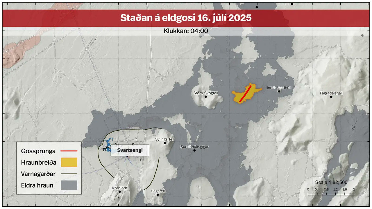
In de loop van september dus de volgende eruptiequote:Magma accumulation under Svartsengi nears eruption threshold, Iceland
Around 6 to 7 million m3 (212 to 247 million ft3) of magma have accumulated beneath Svartsengi, Iceland since the eruption on July 16, 2025. At the current rate of accumulation, the estimated threshold of 12 million m3 (424 million ft3) could be reached in the latter half of September, increasing the likelihood of a new eruption.
Uplift and magma intrusion beneath Svartsengi have continued steadily in recent weeks, according to the Icelandic Meteorological Office (IMO) update posted on September 4.
Model-based estimates indicate that approximately 6 to 7 million m3 (212 to 247 million ft3) of magma have built up in the subsurface reservoir since the most recent eruption.
The July 2025 event released an estimated 12 million m3 (424 million ft3) from the same storage area. Based on patterns observed in previous eruptions, the probability of a new dike intrusion or eruption increases when a similar volume has accumulated again.
Assuming the current rate of accumulation persists, this condition is expected to be met in the second half of September.
However, there remains substantial uncertainty regarding the timing of a possible eruption. Since March 2024, magma volumes released during eruptions have ranged between 12 and 31 million m3 (424 to 1 095 million ft3), suggesting that the threshold is not fixed.
Even minor changes in the rate of magma supply could delay or accelerate the next eruptive event by several weeks.
The latest hazard assessment remains valid until September 16, 2025.
The new lava field, produced during the July eruption, is still classified under “some hazard” (yellow). Zone C (Vogar) has been revised in the updated map, and the hazard of ground collapse into fissures is no longer assessed in that area.
If a new eruption occurs, the most likely source area is between Sundhnúkur and Stóra-Skógfell. Indicators of an imminent eruption include increased microseismicity, rapid ground deformation detected by GPS and fiber-optic instruments, and pressure fluctuations in monitoring boreholes.
Based on previous events, warning times are expected to be short, ranging from 20 minutes to just over 4 hours.
Seismic activity continues west of Lake Kleifarvatn, in the Krýsuvík geothermal region. Land subsidence is currently being measured in the area.
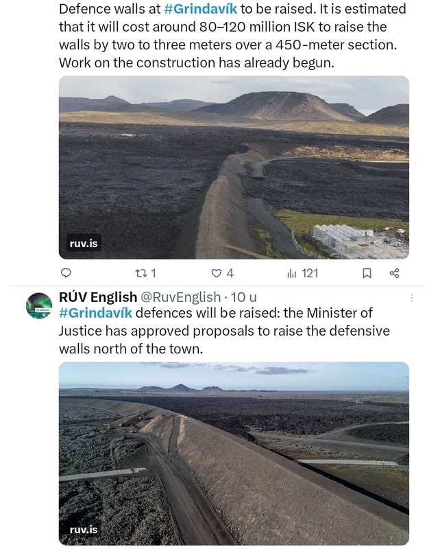
The Minister of Justice has approved proposals to raise the defensive embankments north of Grindavík. The cost of increasing their height by two to three metres along a 450-metre stretch is estimated at ISK 80–120 million.
The minister approved the National Commissioner of the Police’s proposal to add to the barriers north of Grindavík. The embankments will be raised by two to three metres over about 450 metres to enhance the town’s protection against potential lava flow.
Work on the project has already begun, with the cost estimated at ISK 80–120 million.
“We have seen that the defensive embankments have performed well. With this decision we ensure continued protection and safety in the area,” Minister of Justice Þorbjörg Sigríður Gunnlaugsdóttir is quoted as saying in a government statement.
News reports on Monday noted that the team of engineers designing the embankments had sent the ministry a memo in the spring recommending the increase, but no response had yet been received. In its submission to the ministry, the Municipality of Grindavík stated that the project is highly urgent and should begin as soon as possible.
https://construction.is/l(...)ndavik-to-be-raised/
v
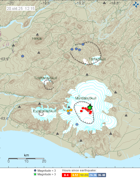

quote:Strong earthquake swarm shakes Katla volcanic system beneath Mýrdalsjökull, Iceland
A strong seismic swarm began beneath Iceland’s Mýrdalsjökull glacier, part of the Katla volcanic system, around 10:30 UTC on October 20, 2025. Several earthquakes above magnitude 3 were recorded, the largest reaching M4.5 at 10:51 UTC. The Icelandic Meteorological Office reports no felt activity and no changes in river levels, conductivity, or deformation, indicating no immediate signs of eruption at the Katla volcano or glacial flooding.
A strong seismic swarm began beneath Iceland’s Mýrdalsjökull glacier around 10:30 UTC on October 20, producing several earthquakes above M3.0 and the largest event of M4.5 at 10:51.
The swarm occurred within the Katla volcanic system, beneath the western part of the ice cap. No felt reports have been received, and hydrological parameters remain stable.
The Icelandic Meteorological Office (IMO) reports that no changes have been detected in the rivers draining the glacier. Water levels, temperature, and conductivity measurements show no deviation from normal values. Those indicators, together with seismic and deformation data, are used to detect early signs of magmatic or hydrothermal activity that can trigger melting or jökulhlaups.
Four earthquakes exceeded magnitude 3, and the largest event, first listed as M4.4 and later revised to M4.5, was recorded at 10:51 UTC about 8.5 km (5.3 miles) east-northeast of Goðabunga at shallow depths up to 2 km (1.2 miles).
According to IMO, the last M3+ event under Mýrdalsjökull occurred on October 3, 2025. In May and June 2023, a similar swarm produced several M3+ earthquakes and one M4.8, also without eruption. Comparable activity was recorded in 2016, when Katla produced a sequence of M4+ events that ended without surface change.
Mýrdalsjökull overlies Katla, one of Iceland’s most active and hazardous subglacial volcanoes. Katla’s caldera lies beneath up to 700 m (2 300 feet) of ice and has produced repeated explosive phreatomagmatic eruptions.
The last major eruption occurred in 1918 and generated a large jökulhlaup that reshaped the Mýrdalssandur outwash plain. Katla’s eruptions typically combine explosive magma–ice interaction with rapid melting that can release large volumes of water and sediment in hours. Because of this setting, Katla remains among the most closely monitored volcanoes in Iceland.
Current data indicate that today’s seismic swarm is consistent with crustal fracturing rather than direct magma intrusion. IMO notes that there are no deformation signals or hydrological anomalies, and the volcano’s Aviation Color Code remains Green. Nevertheless, large earthquakes beneath ice-covered volcanoes can loosen ice and rock, and the agency advises caution regarding localized ice or slope collapse.
Continuous monitoring of Katla integrates seismic, geodetic, and hydrological networks. Particular attention is given to possible changes in the rate and depth of earthquakes, the onset of harmonic tremor that can signal magma or fluid movement, and deformation patterns detected by GPS and satellite interferometry.
Rivers draining the glacier are instrumented to detect any rise in discharge, conductivity, or temperature that could signal subglacial melting. At present, all such measurements remain within normal limits.
The current swarm follows the pattern of intermittent shallow activity typical for Katla. While these swarms do not always precede an eruption, they reflect an active geothermal and tectonic environment beneath the glacier.
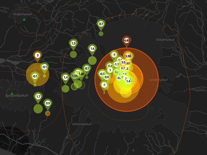
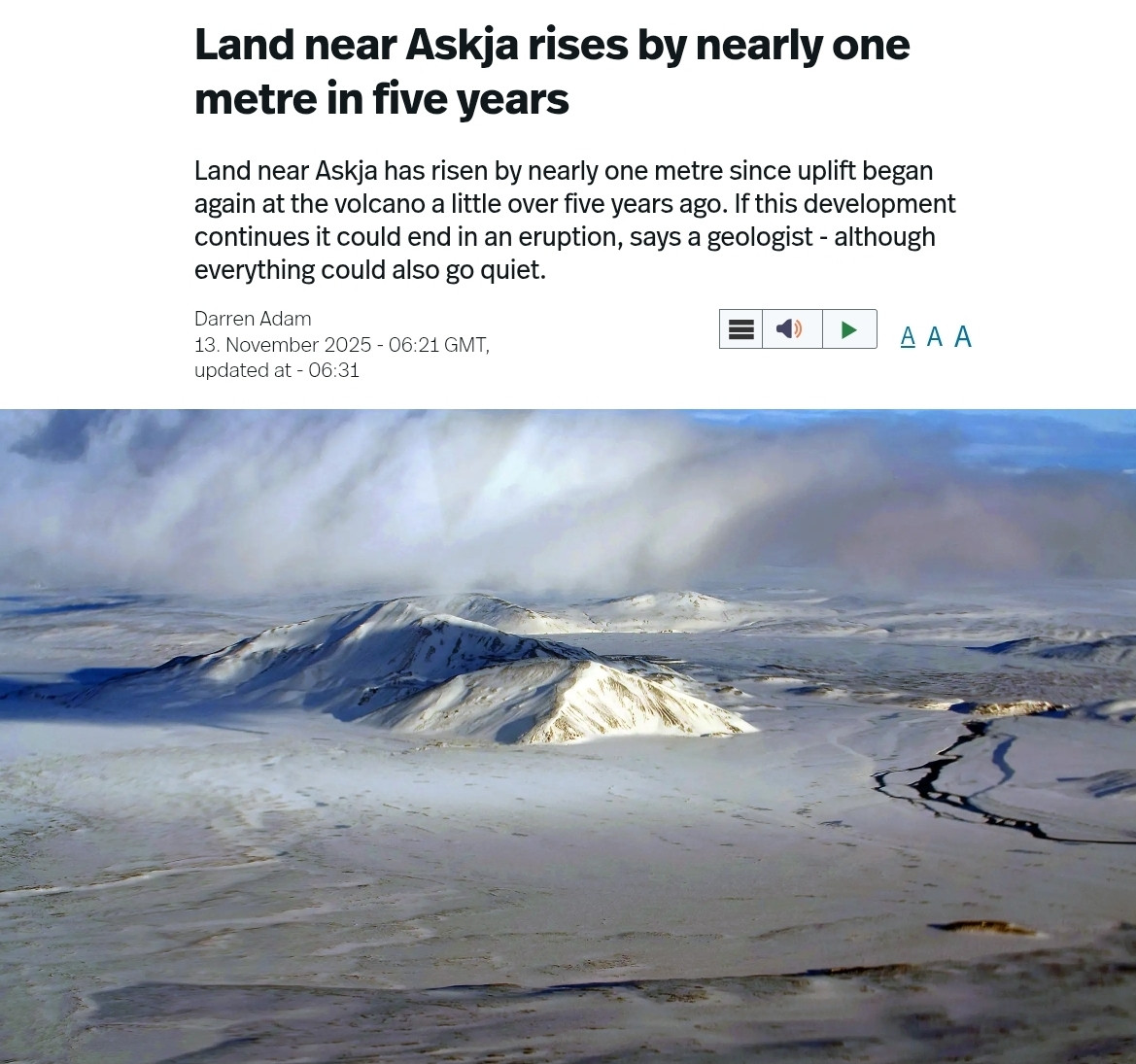
An earthquake of magnitude 3.5 was measured at Askja at 9:39 am on Sunday.
Earthquakes of this size are not very common there, according to Iðunn Kara Valdimarsdóttir, natural hazards specialist.
Six earthquakes of magnitude 3 or greater have been recorded in Askja since 2017, the most recent one in November last year.
Iðunn says land has been rising beneath Askja in recent years, but the earthquake does not necessarily have any particular significance.
No aftershocks have been detected.
Askja is a volcano in a remote part of Iceland's central highlands.
https://www.ruv.is/english/2025-11-10-earthquake-at-askja-458478
v
quote:Glacial outburst flood in Skaftá River confirmed to originate from Vestari-Skaftár caldera, Iceland
A glacial outburst flood in Iceland’s Skaftá River, first detected on December 8, 2025, has been confirmed to originate from the Vestari-Skaftár caldera beneath Vatnajökull ice cap. Flow at the Sveinstind station has decreased to just over 120 m³/s, down from 200 m³/s earlier in the week. Conductivity remains high and hydrogen sulfide continues to be detected along the river, but no impacts on major roads have been reported.
The Icelandic Meteorological Office (IMO) confirmed on December 10 that the ongoing jökulhlaup (glacial outburst flood) in Skaftá River originates from the Vestari-Skaftár caldera beneath Vatnajökull.
The confirmation is based on Sentinel-1 radar imagery, InSAR deformation data, turbulence measurements, and direct field observations by teams from the University of Iceland’s Institute of Earth Sciences and Landsvirkjun.
The discharge at the Sveinstind hydrological station was measured at just over 120 m³/s (4 238 ft³/s), showing a gradual decline from around 160 m³/s (5 650 ft³/s) on December 9 and 200 m³/s (7 063 ft³/s) when the flood began late on December 7.
According to IMO, the flow remains significantly lower than in larger historical Skaftá floods, which have reached up to 3 000 m³/s (105 944 ft³/s). Despite elevated water levels, there have been no disruptions to major roads or settlements downstream.
Conductivity in the river has been increasing, indicating the presence of geothermal meltwater from beneath the glacier.
The smell of sulfur, caused by hydrogen sulfide (H2S) gas, remains noticeable along parts of the Skaftá valley. IMO has advised travelers and field researchers to avoid the Skaftá River above Skaftárdalur and the glacial margins of Skaftárjökull, Tungnárjökull, and Síðujökull due to possible gas accumulation and unstable ice.
Hydrogen sulfide is released when geothermal water, rich in dissolved sulfides, emerges from beneath the ice. In confined areas, such as depressions and river valleys, concentrations can rise to levels that irritate the eyes and respiratory tract.
Although no dangerous concentrations have been measured in inhabited areas, IMO continues to monitor gas conditions as part of the ongoing response.
Although located within the broader Grímsvötn volcanic zone under Vatnajökull, the Skaftár calderas are independent geothermal depressions.
They are not part of the Grímsvötn central volcano system, and floods from Skaftá are driven by geothermal melting, not magmatic activity. Grímsvötn drains primarily toward the Skeiðará River, whereas the Skaftár calderas feed into the Skaftá River
Astrum heeft weer een filmpje over IJsland online gezet.
Bekijk deze YouTube-video
Bekijk deze YouTube-video
Als het niet met een hamer te repareren is, is het een elektrisch probleem.
Het is al even geleden dat de vulkaan is uitgebarsten. De hoeveelheid magma is op zijn hoogst sinds december 2023.
Sukje van 3 maart
Sukje van 3 maart
quote:Land uplift and magma accumulation continue at a similar rate as in recent weeks; magma inflow is slow but steady. According to model calculations, approximately 22.5 million cubic meters of magma have now accumulated beneath Svartsengi since the last eruption in July last year.
Magma has been accumulating beneath Svartsengi for around 210 days, making this the longest continuous accumulation period since the eruptive episode along the Sundhnúkur crater row began in December 2023.
If magma accumulation continues at the same rate, it can be expected that by next week the total volume of magma accumulated since the last eruption will be the largest recorded between eruptions since the start of the eruptive episode.
The large volume of magma and the length of the accumulation period call for further analysis of the possible development of volcanic activity. The Icelandic Meteorological Office is currently revising its scenario assessments for possible developments, and these will be presented in the coming weeks.
It should be noted that a prolonged pause in eruptions is not a clear indication that the eruptive episode at the Sundhnúkur crater row has ended.
https://en.vedur.is/about(...)lation-at-svartsengi

v
quote:Strong earthquake swarm on the Reykjanes Ridge, Iceland
An earthquake swarm with over 300 events over 48 hours is in progress on the Reykjanes Ridge southwest of Eldey, Iceland, since March 23, 2026, with the largest earthquake thus far registered as M4.4. The Icelandic Meteorological Office said there are no indications linking the activity to volcanic processes on the Reykjanes Peninsula.
Seismic data from the Icelandic Meteorological Office (IMO) show that 316 earthquakes were recorded along the Reykjanes Ridge during the 48-hour period ending at 13:55 LT on March 24. Earlier reports noted about 120 events, but the sequence continued to develop and later exceeded 300 recorded earthquakes.
The swarm began approximately 25 km (16 miles) southwest of Eldey, with epicenters primarily clustered around Geirfugladrangur along the Mid-Atlantic Ridge. Magnitude distribution shows that most earthquakes remained small, with 22 events below M1, 135 between M1 and M2, and 143 between M2 and M3, while 16 earthquakes exceeded M3.
The strongest earthquake reached magnitude M4.4 at a depth of 10.1 km (6.3 miles) at 16:30 LT on March 23, marking the largest event recorded in the area since September 2025. Additional significant earthquakes include M4.2 events at depths of 6.8 km (4.2 miles) and 9.1 km (5.7 miles). In total, four earthquakes measuring over magnitude 4 were recorded during the sequence, including an M4.0 event.
Some of the earthquakes were reportedly felt on the Reykjanes Peninsula despite the offshore location of the swarm.
The IMO stated that there are currently no indications linking the seismic activity to volcanic processes on the Reykjanes Peninsula.
Ondanks een lange pauze zijn er geen tekenen dat de eruptiereeks ten einde loopt.
Er zijn geen aanwijzingen dat de eruptiereeks op Sundhnúksgígaröð, op het schiereiland Reykjanes in IJsland, ten einde loopt - ondanks de trage snelheid waarmee magma zich ophoopt.
Volgens een verklaring van Veðurstofa Íslands (IJslandse Meteorologische Dienst), die samen met een nieuwe risicobeoordeling voor het gebied, geldig tot juni, is de kans op magma-intrusies en -uitbarstingen op het schiereiland Reykjanes nog steeds het meest waarschijnlijk.
Sinds de laatste uitbarsting in juli vorig jaar heeft zich onder de Svartsengi-vulkaan iets meer dan 24 miljoen kubieke meter magma opgehoopt.
Zoals eerder gemeld, tonen modelberekeningen aan dat een dergelijk volume nog nooit zo groot is geweest sinds de eruptiereeks op Sundhnúksgígaröð in november 2023 begon.
Zolang de magma-accumulatie doorgaat, blijven magma-intrusies en -erupties op Sundhnúksgígaröð het meest waarschijnlijke scenario. Omdat het volume magma onder Svartsengi nu groter is dan voorheen, is het mogelijk dat de volgende eruptie omvangrijker zal zijn dan eerdere erupties, als het magma geheel of gedeeltelijk het oppervlak bereikt.
De grootste uitbarsting van Krafla na bijna drie jaar van langzame magma-accumulatie.
De verklaring benadrukt dat een langzame ophoping van magma geen duidelijke indicatie is dat er geen eruptie zal plaatsvinden, en verwijst naar de eruptiereeks bij Krafla tussen 1975 en 1984.
Tussen 1975 en 1984 vonden er 12 magma-intrusies plaats, waarvan er 9 tot een eruptie leidden. De snelheid waarmee magma binnenstroomde nam aanzienlijk af na de voorlaatste eruptie in november 1981.
Er gingen vervolgens bijna drie jaar voorbij voordat de volgende uitbarsting plaatsvond, die tevens de grootste en laatste uitbarsting was, in augustus 1984.
https://www.ijsland-enzo.nl/ijsland/actueel_nieuwspagina.asp
v
quote:Magma accumulation exceeds 25 million m³ beneath Svartsengi, Iceland
More than 25 million m³ (883 million ft³) of magma has accumulated beneath Svartsengi, Iceland, since the last eruption in July 2025, the Icelandic Me]teorological Office (IMO) reported on April 28, 2026. IMO said ground uplift continues at up to 2 cm (0.8 inches) per month, while magmatic dike propagation toward the Sundhnúkur crater row remains the most likely scenario and could lead to an eruption.
IMO said magma accumulation beneath Svartsengi remains slow but steady, with continued deformation in the volcanic system on the Reykjanes Peninsula. Model calculations show that more than 25 million m³ of magma has accumulated beneath the area since the July 2025 eruption. This is the largest volume measured since the eruptions began on the Sundhnúkur crater row.
Rising pressure in the system keeps dike propagation from Svartsengi toward the Sundhnúkur crater row as the most likely scenario. Based on previous events in the area, warning times before a new dike intrusion or eruption should be expected to remain short, ranging from 20 minutes to just over 4 hours.
Seismic activity near the dike region remains low, although there was a slight increase over the past two weeks, with most earthquakes below M1.
A recent InSAR image covering March 16 to April 18, 2026, shows clear uplift in the Svartsengi region but no deformation elsewhere on the Reykjanes Peninsula during that period.
Model calculations, based in part on measurements of ground uplift, show that the rate of magma accumulation beneath Svartsengi has never been slower.
“The fact that magma accumulation has never been slower, while the amount of magma beneath Svartsengi has never been greater between eruptions, increases the uncertainty about developments in the area,” IMO said.
Slow magma accumulation is not a clear indication that an eruption will not occur. The most immediate example of this is the Krafla Fires eruption sequence from 1975 to 1984.
During the period from November 1981 to August 1984, the rate of magma inflow beneath Krafla decreased significantly. Despite the slow rate of magma accumulation for nearly three years, an eruption eventually occurred in August 1984, which was also the largest eruption of the Krafla Fires. Following the last eruption, continued ground uplift was measured until 1989, without culminating in an eruption.
Although there are fundamental differences between Krafla and the volcanic systems on the Reykjanes Peninsula, the comparison suggests that magma accumulation beneath Svartsengi could continue for several years and that the possibility of a new eruption remains.
“As long as magma accumulation continues, a magma intrusion and eruption on the Sundhnúkur crater row remains the most likely scenario,” IMO said on March 31. “Because the amount of magma beneath Svartsengi is now greater than before, it is possible that the next eruption could be larger than previous ones, if the magma reaches the surface in part or in full.”
No data indicate that the eruption sequence on the Sundhnúkur crater row is coming to an end, and the Reykjanes-Svartsengi volcanic system remains at Volcano Alert Level 2, "Heightened Unrest" (orange), as issued by the Icelandic Meteorological Office.
The hazard assessment remains unchanged and valid until June 30, 2026.
The Svartsengi unrest is part of the Sundhnúkur crater row eruption sequence, which began in late 2023. IMO's earlier updates reported continued recharge beneath Svartsengi after the July 2025 eruption, with the accumulated volume rising through early 2026 before exceeding 25 million m³ at the end of April.
quote:
Because the amount of magma beneath Svartsengi is now greater than before, it is possible that the next eruption could be larger than previous ones, if the magma reaches the surface in part or in full.”
|
|
| Forum Opties | |
|---|---|
| Forumhop: | |
| Hop naar: | |