WKN Weer, Klimaat en Natuurrampen
Lees alles over het onstuimige weer op onze planeet, volg orkanen en tornado's, zie hoe vulkanen uitbarsten en hoe Moeder Aarde beeft bij een aardbeving. Alles over de verwoestende kracht van onze planeet en tal van andere natuurverschijnselen.


Spannend, ik vlieg hier volgende week heen. Plan was om even door Grindavik te rijden alvorens oostwaarts te gaan, maar dat zal er nu wel niet inzitten. 
Gourmetten of steengrillen?
Echt hoor, zeg je dit, en nog geen 24 uur laterquote:
In this world of evil and darkness I'm looking for the one girl that has the power to bring light into my heart. A light so pure that my evil thoughts about this world and the people living on it will vanish and I'll finally experience true love.

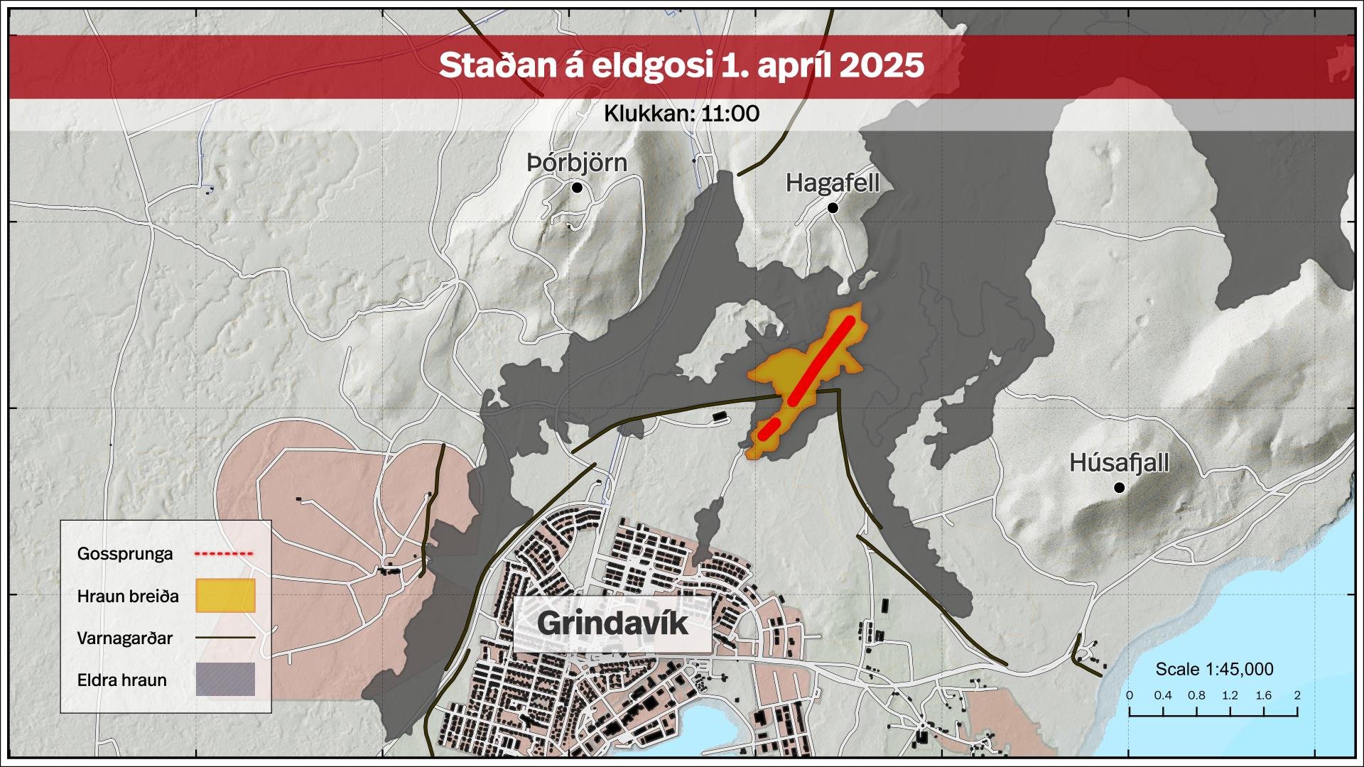
Het neemt al weer af in hevigheid ... maar misschien komt er meerquote:Op dinsdag 1 april 2025 15:08 schreef Silenus het volgende:
Spannend, ik vlieg hier volgende week heen. Plan was om even door Grindavik te rijden alvorens oostwaarts te gaan, maar dat zal er nu wel niet inzitten.

Ja moest er ook hard om lachenquote:
[..]
Echt hoor, zeg je dit, en nog geen 24 uur later
Lekker bezig @Dr_Flash
Oh how you'd have a happy life, if you did the things you like
quote:Op dinsdag 1 april 2025 19:33 schreef chufi het volgende:
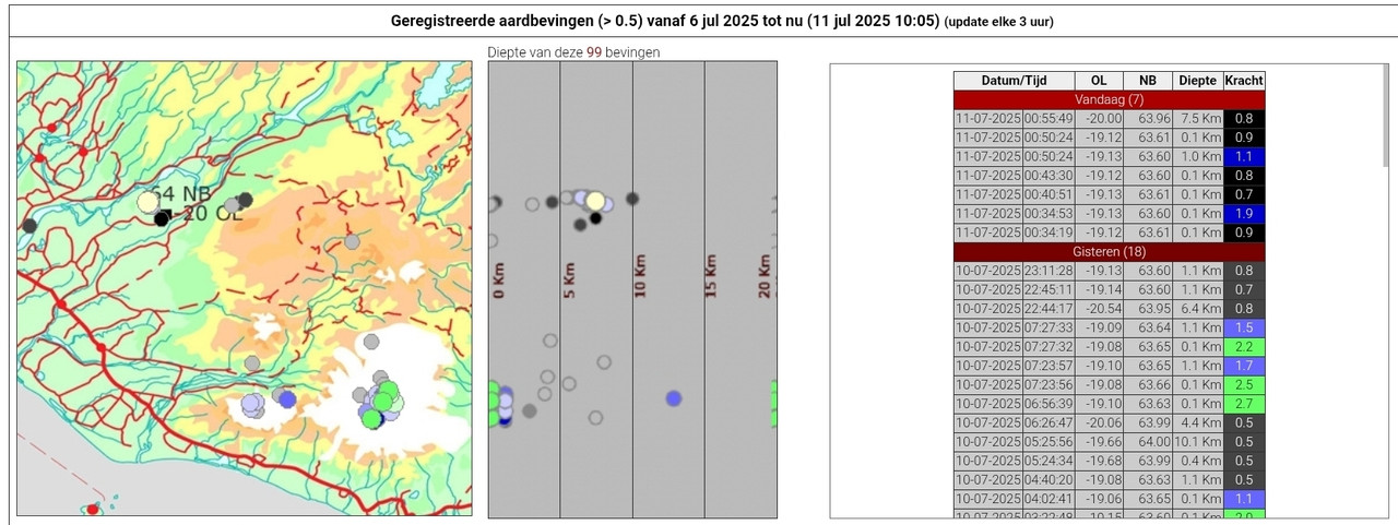
Ja de bevingen gaan maar door 135 laatste uur

Het hele westen van IJsland beeft?

Dalek krijg ik nog de schuld ookquote:
[..]
Echt hoor, zeg je dit, en nog geen 24 uur later
Salivili hipput tupput tapput äppyt tipput hilijalleen
Mogelijk andere locatie, want dit stelde niet veel voorquote:
[..]
Het neemt al weer af in hevigheid ... maar misschien komt er meer
Altijd onderweg naar het avontuur

De instroom van magma was al minder, het zou zomaar kunnen dat dit de laatste eruptie was.quote:
[..]
Mogelijk andere locatie, want dit stelde niet veel voor
De waarheid in iemands hoofd is vaak onbuigzamer dan het sterkste staal.

De aardbevingen blijven aanhouden. Een volgende eruptie zou zo kunnen.
De meeste zitten nu weer in het zuiden (west van Grindavik).
De meeste zitten nu weer in het zuiden (west van Grindavik).

v
Heeft die grote kas het gered?
In this world of evil and darkness I'm looking for the one girl that has the power to bring light into my heart. A light so pure that my evil thoughts about this world and the people living on it will vanish and I'll finally experience true love.
Bekijk deze YouTube-video
Nog een IJslands YouTube kanaal met info. En ook een beetje humor af en toe.
Nog een IJslands YouTube kanaal met info. En ook een beetje humor af en toe.
Als het niet met een hamer te repareren is, is het een elektrisch probleem.
Bekijk deze YouTube-video
Het is in ieder geval niet OVER de opgeworpen dam gekomen
Het is in ieder geval niet OVER de opgeworpen dam gekomen
quote:Apr 7, 2025 ICELAND
I place special emphasis on the area where the April 1st eruption occurred under the lava berm that was build to protect the town as i follow the new fissure by Grindavik. The big crack in the ground is where i though the eruption had started from the fist news, but the new eruptive fissure cracked open only 20 meters further west. But the most remarkable feature has to be the little fissure under the lava berm where a volcanic eruption rips apart a man man structure, made in order to hold lava back. This could be a major tourist sensation, if the landscape stays like this.
Als het niet met een hamer te repareren is, is het een elektrisch probleem.
Bekijk deze YouTube-videoquote:Sinds vanochtend vroeg (13 mei) zijn er ongeveer 240 aardbevingen geregistreerd op Grímsey, waarvan de zwaarste een kracht van 4,7 had.
Een inwoner van Grímsey werd wakker met de grootste aardbeving in de aardbevingszwerm die momenteel ten oosten van het eiland plaatsvindt. In deze reeks zijn zo'n 240 aardbevingen geregistreerd, waarvan de grootste met een kracht van 4,7 vanochtend om 4 uur plaatsvond.
Halla Ingólfsdóttir, een inwoner van Grímsey, zegt dat ze wakker werd door de zwaarste aardbeving en flauwviel. Ze voelde er daarna nog een en viel daarna weer in slaap.
De grootste naschok was 3,5, maar Iðunn Kara Valdimarsdóttir van het IJslandse Meteorologische Bureau zegt dat er meerdere naschokken zijn gemeten van 3 of lager, maar dat de meeste een kracht hadden van minder dan 2.
Halla zegt dat ze geen aardbevingen meer heeft gevoeld. De inwoners van Grímsey zijn echter wel gewend aan aardbevingen. In de herfst van 2022 duurde een reeks aardbevingen enkele weken.
"Gewend en niet gewend – dit is altijd oncomfortabel, vooral als ze zo groot worden. Jij hebt misschien minder last van dit kleinere exemplaar, maar het is natuurlijk altijd erg oncomfortabel, tenminste voor mij," zegt Halla.
https://www.ijsland-enzo.nl/ijsland/actueel_nieuwspagina.asp
v

Het gaat weer beginnen, behoorlijk wat activiteit.
De waarheid in iemands hoofd is vaak onbuigzamer dan het sterkste staal.
Yup, begonnen:quote:Op maandag 7 juli 2025 14:02 schreef bedachtzaam het volgende:
Het gaat weer beginnen, behoorlijk wat activiteit.
https://www.ruv.is/englis(...)-in-grindavik-448677
Niet meer zo spannend eigenlijk die cyclische uitbarstingen.


Nu weer prachtige live beelden van Isak
SPOILEROm spoilers te kunnen lezen moet je zijn ingelogd. Je moet je daarvoor eerst gratis Registreren. Ook kun je spoilers niet lezen als je een ban hebt.
quote:
Nu weer prachtige live beelden van IsakSpectaculaire beelden.SPOILEROm spoilers te kunnen lezen moet je zijn ingelogd. Je moet je daarvoor eerst gratis Registreren. Ook kun je spoilers niet lezen als je een ban hebt.
Lava en grondwater v
v
Hier een samenvatting van Isaks streams van gisteren ..
Bekijk deze YouTube-video
Morgen is ie weer live
Bekijk deze YouTube-video
Morgen is ie weer live
In de loop van september dus de volgende eruptiequote:Magma accumulation under Svartsengi nears eruption threshold, Iceland
Around 6 to 7 million m3 (212 to 247 million ft3) of magma have accumulated beneath Svartsengi, Iceland since the eruption on July 16, 2025. At the current rate of accumulation, the estimated threshold of 12 million m3 (424 million ft3) could be reached in the latter half of September, increasing the likelihood of a new eruption.
Uplift and magma intrusion beneath Svartsengi have continued steadily in recent weeks, according to the Icelandic Meteorological Office (IMO) update posted on September 4.
Model-based estimates indicate that approximately 6 to 7 million m3 (212 to 247 million ft3) of magma have built up in the subsurface reservoir since the most recent eruption.
The July 2025 event released an estimated 12 million m3 (424 million ft3) from the same storage area. Based on patterns observed in previous eruptions, the probability of a new dike intrusion or eruption increases when a similar volume has accumulated again.
Assuming the current rate of accumulation persists, this condition is expected to be met in the second half of September.
However, there remains substantial uncertainty regarding the timing of a possible eruption. Since March 2024, magma volumes released during eruptions have ranged between 12 and 31 million m3 (424 to 1 095 million ft3), suggesting that the threshold is not fixed.
Even minor changes in the rate of magma supply could delay or accelerate the next eruptive event by several weeks.
The latest hazard assessment remains valid until September 16, 2025.
The new lava field, produced during the July eruption, is still classified under “some hazard” (yellow). Zone C (Vogar) has been revised in the updated map, and the hazard of ground collapse into fissures is no longer assessed in that area.
If a new eruption occurs, the most likely source area is between Sundhnúkur and Stóra-Skógfell. Indicators of an imminent eruption include increased microseismicity, rapid ground deformation detected by GPS and fiber-optic instruments, and pressure fluctuations in monitoring boreholes.
Based on previous events, warning times are expected to be short, ranging from 20 minutes to just over 4 hours.
Seismic activity continues west of Lake Kleifarvatn, in the Krýsuvík geothermal region. Land subsidence is currently being measured in the area.
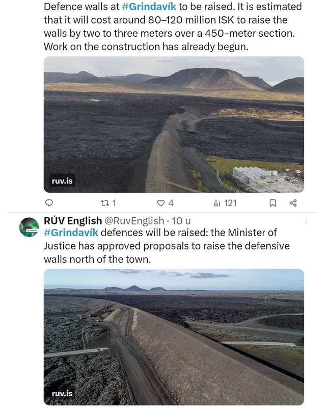
The Minister of Justice has approved proposals to raise the defensive embankments north of Grindavík. The cost of increasing their height by two to three metres along a 450-metre stretch is estimated at ISK 80–120 million.
The minister approved the National Commissioner of the Police’s proposal to add to the barriers north of Grindavík. The embankments will be raised by two to three metres over about 450 metres to enhance the town’s protection against potential lava flow.
Work on the project has already begun, with the cost estimated at ISK 80–120 million.
“We have seen that the defensive embankments have performed well. With this decision we ensure continued protection and safety in the area,” Minister of Justice Þorbjörg Sigríður Gunnlaugsdóttir is quoted as saying in a government statement.
News reports on Monday noted that the team of engineers designing the embankments had sent the ministry a memo in the spring recommending the increase, but no response had yet been received. In its submission to the ministry, the Municipality of Grindavík stated that the project is highly urgent and should begin as soon as possible.
https://construction.is/l(...)ndavik-to-be-raised/
v
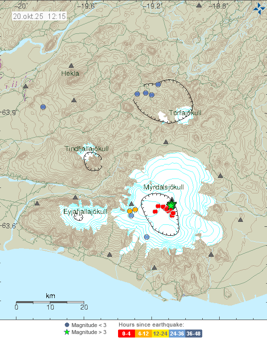
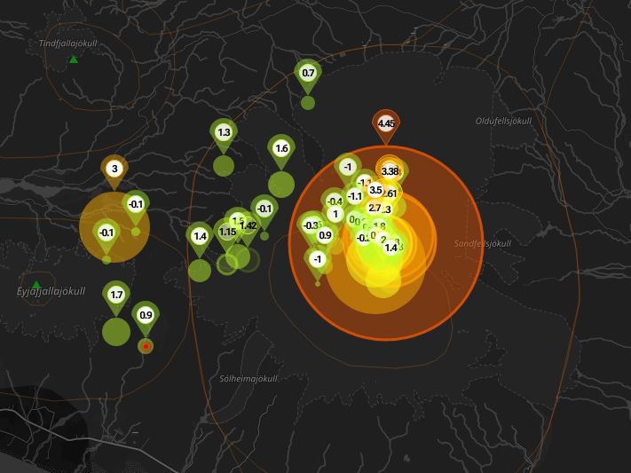

quote:Strong earthquake swarm shakes Katla volcanic system beneath Mýrdalsjökull, Iceland
A strong seismic swarm began beneath Iceland’s Mýrdalsjökull glacier, part of the Katla volcanic system, around 10:30 UTC on October 20, 2025. Several earthquakes above magnitude 3 were recorded, the largest reaching M4.5 at 10:51 UTC. The Icelandic Meteorological Office reports no felt activity and no changes in river levels, conductivity, or deformation, indicating no immediate signs of eruption at the Katla volcano or glacial flooding.
A strong seismic swarm began beneath Iceland’s Mýrdalsjökull glacier around 10:30 UTC on October 20, producing several earthquakes above M3.0 and the largest event of M4.5 at 10:51.
The swarm occurred within the Katla volcanic system, beneath the western part of the ice cap. No felt reports have been received, and hydrological parameters remain stable.
The Icelandic Meteorological Office (IMO) reports that no changes have been detected in the rivers draining the glacier. Water levels, temperature, and conductivity measurements show no deviation from normal values. Those indicators, together with seismic and deformation data, are used to detect early signs of magmatic or hydrothermal activity that can trigger melting or jökulhlaups.
Four earthquakes exceeded magnitude 3, and the largest event, first listed as M4.4 and later revised to M4.5, was recorded at 10:51 UTC about 8.5 km (5.3 miles) east-northeast of Goðabunga at shallow depths up to 2 km (1.2 miles).
According to IMO, the last M3+ event under Mýrdalsjökull occurred on October 3, 2025. In May and June 2023, a similar swarm produced several M3+ earthquakes and one M4.8, also without eruption. Comparable activity was recorded in 2016, when Katla produced a sequence of M4+ events that ended without surface change.
Mýrdalsjökull overlies Katla, one of Iceland’s most active and hazardous subglacial volcanoes. Katla’s caldera lies beneath up to 700 m (2 300 feet) of ice and has produced repeated explosive phreatomagmatic eruptions.
The last major eruption occurred in 1918 and generated a large jökulhlaup that reshaped the Mýrdalssandur outwash plain. Katla’s eruptions typically combine explosive magma–ice interaction with rapid melting that can release large volumes of water and sediment in hours. Because of this setting, Katla remains among the most closely monitored volcanoes in Iceland.
Current data indicate that today’s seismic swarm is consistent with crustal fracturing rather than direct magma intrusion. IMO notes that there are no deformation signals or hydrological anomalies, and the volcano’s Aviation Color Code remains Green. Nevertheless, large earthquakes beneath ice-covered volcanoes can loosen ice and rock, and the agency advises caution regarding localized ice or slope collapse.
Continuous monitoring of Katla integrates seismic, geodetic, and hydrological networks. Particular attention is given to possible changes in the rate and depth of earthquakes, the onset of harmonic tremor that can signal magma or fluid movement, and deformation patterns detected by GPS and satellite interferometry.
Rivers draining the glacier are instrumented to detect any rise in discharge, conductivity, or temperature that could signal subglacial melting. At present, all such measurements remain within normal limits.
The current swarm follows the pattern of intermittent shallow activity typical for Katla. While these swarms do not always precede an eruption, they reflect an active geothermal and tectonic environment beneath the glacier.
An earthquake of magnitude 3.5 was measured at Askja at 9:39 am on Sunday.
Earthquakes of this size are not very common there, according to Iðunn Kara Valdimarsdóttir, natural hazards specialist.
Six earthquakes of magnitude 3 or greater have been recorded in Askja since 2017, the most recent one in November last year.
Iðunn says land has been rising beneath Askja in recent years, but the earthquake does not necessarily have any particular significance.
No aftershocks have been detected.
Askja is a volcano in a remote part of Iceland's central highlands.
https://www.ruv.is/english/2025-11-10-earthquake-at-askja-458478
v
quote:Glacial outburst flood in Skaftá River confirmed to originate from Vestari-Skaftár caldera, Iceland
A glacial outburst flood in Iceland’s Skaftá River, first detected on December 8, 2025, has been confirmed to originate from the Vestari-Skaftár caldera beneath Vatnajökull ice cap. Flow at the Sveinstind station has decreased to just over 120 m³/s, down from 200 m³/s earlier in the week. Conductivity remains high and hydrogen sulfide continues to be detected along the river, but no impacts on major roads have been reported.
The Icelandic Meteorological Office (IMO) confirmed on December 10 that the ongoing jökulhlaup (glacial outburst flood) in Skaftá River originates from the Vestari-Skaftár caldera beneath Vatnajökull.
The confirmation is based on Sentinel-1 radar imagery, InSAR deformation data, turbulence measurements, and direct field observations by teams from the University of Iceland’s Institute of Earth Sciences and Landsvirkjun.
The discharge at the Sveinstind hydrological station was measured at just over 120 m³/s (4 238 ft³/s), showing a gradual decline from around 160 m³/s (5 650 ft³/s) on December 9 and 200 m³/s (7 063 ft³/s) when the flood began late on December 7.
According to IMO, the flow remains significantly lower than in larger historical Skaftá floods, which have reached up to 3 000 m³/s (105 944 ft³/s). Despite elevated water levels, there have been no disruptions to major roads or settlements downstream.
Conductivity in the river has been increasing, indicating the presence of geothermal meltwater from beneath the glacier.
The smell of sulfur, caused by hydrogen sulfide (H2S) gas, remains noticeable along parts of the Skaftá valley. IMO has advised travelers and field researchers to avoid the Skaftá River above Skaftárdalur and the glacial margins of Skaftárjökull, Tungnárjökull, and Síðujökull due to possible gas accumulation and unstable ice.
Hydrogen sulfide is released when geothermal water, rich in dissolved sulfides, emerges from beneath the ice. In confined areas, such as depressions and river valleys, concentrations can rise to levels that irritate the eyes and respiratory tract.
Although no dangerous concentrations have been measured in inhabited areas, IMO continues to monitor gas conditions as part of the ongoing response.
Although located within the broader Grímsvötn volcanic zone under Vatnajökull, the Skaftár calderas are independent geothermal depressions.
They are not part of the Grímsvötn central volcano system, and floods from Skaftá are driven by geothermal melting, not magmatic activity. Grímsvötn drains primarily toward the Skeiðará River, whereas the Skaftár calderas feed into the Skaftá River
Astrum heeft weer een filmpje over IJsland online gezet.
Bekijk deze YouTube-video
Bekijk deze YouTube-video
Als het niet met een hamer te repareren is, is het een elektrisch probleem.
Het is al even geleden dat de vulkaan is uitgebarsten. De hoeveelheid magma is op zijn hoogst sinds december 2023.
Sukje van 3 maart
Sukje van 3 maart
quote:Land uplift and magma accumulation continue at a similar rate as in recent weeks; magma inflow is slow but steady. According to model calculations, approximately 22.5 million cubic meters of magma have now accumulated beneath Svartsengi since the last eruption in July last year.
Magma has been accumulating beneath Svartsengi for around 210 days, making this the longest continuous accumulation period since the eruptive episode along the Sundhnúkur crater row began in December 2023.
If magma accumulation continues at the same rate, it can be expected that by next week the total volume of magma accumulated since the last eruption will be the largest recorded between eruptions since the start of the eruptive episode.
The large volume of magma and the length of the accumulation period call for further analysis of the possible development of volcanic activity. The Icelandic Meteorological Office is currently revising its scenario assessments for possible developments, and these will be presented in the coming weeks.
It should be noted that a prolonged pause in eruptions is not a clear indication that the eruptive episode at the Sundhnúkur crater row has ended.
https://en.vedur.is/about(...)lation-at-svartsengi

v
quote:Strong earthquake swarm on the Reykjanes Ridge, Iceland
An earthquake swarm with over 300 events over 48 hours is in progress on the Reykjanes Ridge southwest of Eldey, Iceland, since March 23, 2026, with the largest earthquake thus far registered as M4.4. The Icelandic Meteorological Office said there are no indications linking the activity to volcanic processes on the Reykjanes Peninsula.
Seismic data from the Icelandic Meteorological Office (IMO) show that 316 earthquakes were recorded along the Reykjanes Ridge during the 48-hour period ending at 13:55 LT on March 24. Earlier reports noted about 120 events, but the sequence continued to develop and later exceeded 300 recorded earthquakes.
The swarm began approximately 25 km (16 miles) southwest of Eldey, with epicenters primarily clustered around Geirfugladrangur along the Mid-Atlantic Ridge. Magnitude distribution shows that most earthquakes remained small, with 22 events below M1, 135 between M1 and M2, and 143 between M2 and M3, while 16 earthquakes exceeded M3.
The strongest earthquake reached magnitude M4.4 at a depth of 10.1 km (6.3 miles) at 16:30 LT on March 23, marking the largest event recorded in the area since September 2025. Additional significant earthquakes include M4.2 events at depths of 6.8 km (4.2 miles) and 9.1 km (5.7 miles). In total, four earthquakes measuring over magnitude 4 were recorded during the sequence, including an M4.0 event.
Some of the earthquakes were reportedly felt on the Reykjanes Peninsula despite the offshore location of the swarm.
The IMO stated that there are currently no indications linking the seismic activity to volcanic processes on the Reykjanes Peninsula.
Ondanks een lange pauze zijn er geen tekenen dat de eruptiereeks ten einde loopt.
Er zijn geen aanwijzingen dat de eruptiereeks op Sundhnúksgígaröð, op het schiereiland Reykjanes in IJsland, ten einde loopt - ondanks de trage snelheid waarmee magma zich ophoopt.
Volgens een verklaring van Veðurstofa Íslands (IJslandse Meteorologische Dienst), die samen met een nieuwe risicobeoordeling voor het gebied, geldig tot juni, is de kans op magma-intrusies en -uitbarstingen op het schiereiland Reykjanes nog steeds het meest waarschijnlijk.
Sinds de laatste uitbarsting in juli vorig jaar heeft zich onder de Svartsengi-vulkaan iets meer dan 24 miljoen kubieke meter magma opgehoopt.
Zoals eerder gemeld, tonen modelberekeningen aan dat een dergelijk volume nog nooit zo groot is geweest sinds de eruptiereeks op Sundhnúksgígaröð in november 2023 begon.
Zolang de magma-accumulatie doorgaat, blijven magma-intrusies en -erupties op Sundhnúksgígaröð het meest waarschijnlijke scenario. Omdat het volume magma onder Svartsengi nu groter is dan voorheen, is het mogelijk dat de volgende eruptie omvangrijker zal zijn dan eerdere erupties, als het magma geheel of gedeeltelijk het oppervlak bereikt.
De grootste uitbarsting van Krafla na bijna drie jaar van langzame magma-accumulatie.
De verklaring benadrukt dat een langzame ophoping van magma geen duidelijke indicatie is dat er geen eruptie zal plaatsvinden, en verwijst naar de eruptiereeks bij Krafla tussen 1975 en 1984.
Tussen 1975 en 1984 vonden er 12 magma-intrusies plaats, waarvan er 9 tot een eruptie leidden. De snelheid waarmee magma binnenstroomde nam aanzienlijk af na de voorlaatste eruptie in november 1981.
Er gingen vervolgens bijna drie jaar voorbij voordat de volgende uitbarsting plaatsvond, die tevens de grootste en laatste uitbarsting was, in augustus 1984.
https://www.ijsland-enzo.nl/ijsland/actueel_nieuwspagina.asp
v
quote:Magma accumulation exceeds 25 million m³ beneath Svartsengi, Iceland
More than 25 million m³ (883 million ft³) of magma has accumulated beneath Svartsengi, Iceland, since the last eruption in July 2025, the Icelandic Me]teorological Office (IMO) reported on April 28, 2026. IMO said ground uplift continues at up to 2 cm (0.8 inches) per month, while magmatic dike propagation toward the Sundhnúkur crater row remains the most likely scenario and could lead to an eruption.
IMO said magma accumulation beneath Svartsengi remains slow but steady, with continued deformation in the volcanic system on the Reykjanes Peninsula. Model calculations show that more than 25 million m³ of magma has accumulated beneath the area since the July 2025 eruption. This is the largest volume measured since the eruptions began on the Sundhnúkur crater row.
Rising pressure in the system keeps dike propagation from Svartsengi toward the Sundhnúkur crater row as the most likely scenario. Based on previous events in the area, warning times before a new dike intrusion or eruption should be expected to remain short, ranging from 20 minutes to just over 4 hours.
Seismic activity near the dike region remains low, although there was a slight increase over the past two weeks, with most earthquakes below M1.
A recent InSAR image covering March 16 to April 18, 2026, shows clear uplift in the Svartsengi region but no deformation elsewhere on the Reykjanes Peninsula during that period.
Model calculations, based in part on measurements of ground uplift, show that the rate of magma accumulation beneath Svartsengi has never been slower.
“The fact that magma accumulation has never been slower, while the amount of magma beneath Svartsengi has never been greater between eruptions, increases the uncertainty about developments in the area,” IMO said.
Slow magma accumulation is not a clear indication that an eruption will not occur. The most immediate example of this is the Krafla Fires eruption sequence from 1975 to 1984.
During the period from November 1981 to August 1984, the rate of magma inflow beneath Krafla decreased significantly. Despite the slow rate of magma accumulation for nearly three years, an eruption eventually occurred in August 1984, which was also the largest eruption of the Krafla Fires. Following the last eruption, continued ground uplift was measured until 1989, without culminating in an eruption.
Although there are fundamental differences between Krafla and the volcanic systems on the Reykjanes Peninsula, the comparison suggests that magma accumulation beneath Svartsengi could continue for several years and that the possibility of a new eruption remains.
“As long as magma accumulation continues, a magma intrusion and eruption on the Sundhnúkur crater row remains the most likely scenario,” IMO said on March 31. “Because the amount of magma beneath Svartsengi is now greater than before, it is possible that the next eruption could be larger than previous ones, if the magma reaches the surface in part or in full.”
No data indicate that the eruption sequence on the Sundhnúkur crater row is coming to an end, and the Reykjanes-Svartsengi volcanic system remains at Volcano Alert Level 2, "Heightened Unrest" (orange), as issued by the Icelandic Meteorological Office.
The hazard assessment remains unchanged and valid until June 30, 2026.
The Svartsengi unrest is part of the Sundhnúkur crater row eruption sequence, which began in late 2023. IMO's earlier updates reported continued recharge beneath Svartsengi after the July 2025 eruption, with the accumulated volume rising through early 2026 before exceeding 25 million m³ at the end of April.
quote:
Because the amount of magma beneath Svartsengi is now greater than before, it is possible that the next eruption could be larger than previous ones, if the magma reaches the surface in part or in full.”
|
|
| Forum Opties | |
|---|---|
| Forumhop: | |
| Hop naar: | |