WKN Weer, Klimaat en Natuurrampen
Lees alles over het onstuimige weer op onze planeet, volg orkanen en tornado's, zie hoe vulkanen uitbarsten en hoe Moeder Aarde beeft bij een aardbeving. Alles over de verwoestende kracht van onze planeet en tal van andere natuurverschijnselen.


informatie:
http://en.vedur.is/earthquakes-and-volcanism/earthquakes/
http://nl.wikipedia.org/wiki/Gr%C3%ADmsv%C3%B6tn
http://www.jonfr.com/volcano/
http://www.barthokriek.nl/ondertiteling/lijsten/vulkanologie.htm
Metingen & Bevingen
Aardbevingen IJsland
http://hraun.vedur.is/ja/vatnajokulsvoktun/grf_trem.html
http://hraun.vedur.is/ja/englishweb/tremor.html
Metingsoverzicht per gebied
Waar zitten de bevingen - 3D view
De verzakking van de Bardarbunga caldera
Bevingen over het eiland heen
Meeste meet gegevens die hier boven staan op 1 pagina verzameld
Interactief kaartje met o.a. bevingen. (druk op de knop layers en kies earthquakes)
Nieuws:
http://www.ijsland-enzo.nl/index.asp
http://www.icenews.is/
http://icelandreview.com/
http://www.luchtvaartnieuws.nl/
Webcams:
http://www.livefromiceland.is/webcams/bardarbunga/
http://www.livefromiceland.is/webcams/bardarbunga-2/
https://www.ruv.is/frett/(...)svaedinu-borgarfjall
https://www.visir.is/g/20(...)-i-beinni-utsendingu
https://www.vf.is/frettir/keilir-i-beinni-utsendingu-vikurfretta
Relevante topics:
http://forum.fok.nl/topic/1554192
http://forum.fok.nl/topic/959967
http://forum.fok.nl/topic/1682753
Krafla


Mijn vriendin moet daar 1 t/m 3 september heen, is dat uberhaupt te doen nu? Ben niet helemaal op de hoogte of heel IJsland plat ligt nu.
Ligt niet plat.quote:Op woensdag 10 augustus 2022 11:28 schreef HulkHeld het volgende:
Mijn vriendin moet daar 1 t/m 3 september heen, is dat uberhaupt te doen nu? Ben niet helemaal op de hoogte of heel IJsland plat ligt nu.
Het is niet heel ver van de hoofdstad.
Viel tegen idd. Dit was vannacht.quote:Op woensdag 10 augustus 2022 11:35 schreef chufi het volgende:
Eindelijk weer beeld, na dagen mist rook etc

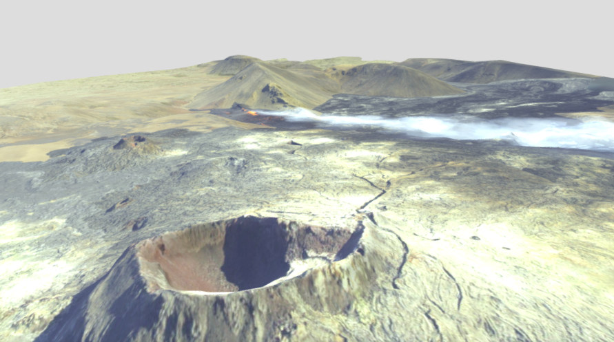
Een 3d Modelletje 
https://sketchfab.com/3d-(...)471fb1756280734225ad
Met wat draaien krijg je mooi in beeld hoe het ligt tov de krater van vorig jaar
https://sketchfab.com/3d-(...)471fb1756280734225ad
Met wat draaien krijg je mooi in beeld hoe het ligt tov de krater van vorig jaar
No I don't want fiber in my soda. I don't want protein in my waffles. Stop adding random shit to perfectly good food.


Mist/wolken: ja, rook: nee. Hij rookte juist bijzonder weinig voor een vulkaan.quote:
Eindelijk weer beeld, na dagen mist rook etc

De foto is van 6 augustus. Ik was toevallig op vakantie op IJsland. Tegelijk mijn eerste aardbeving gevoeld en voor het eerst een vulkaan gezien irl
I've got 99 problems, but a bitch ain't one.

En hoe voelt dat ?quote:Op zondag 11 september 2022 01:07 schreef Puntenjager het volgende:
[..]
Mist/wolken: ja, rook: nee. Hij rookte juist bijzonder weinig voor een vulkaan.
[ afbeelding ]
De foto is van 6 augustus. Ik was toevallig op vakantie op IJsland. Tegelijk mijn eerste aardbeving gevoeld en voor het eerst een vulkaan gezien irl

Ik heb helaas maar 1 aardbeving (aardbevinkje) gevoeld. Naar ik aanneem 1 van de wat zwaardere bevingen van 3,5 a 4 op de schaal van richter. In het nieuws werd gemeld dat er letterlijk tienduizenden aardbevingen gemeten werden in dagen vooraf en gedurdende de eruptie. Echter dan spreek je over trillingen die een seismograaf kan meten. Niet wat jij als mens voelt. Tevens waren de bevingen in een gebied op 35 km afstand van Reykjavik.quote:
Hoe dat voelt? Het was een korte schok alsof iemand naast je iets heel zwaars laat omvallen op een houten vloer. Echter de vloer was van gewapend beton in een moderne flat. Ook was de trilling te sterk en veel meer horizontaal ipv vertikaal, wat je hebt als iets valt of als iemand gaat lopen springen.
Er waren meer bevingen die voelbaar waren, maar toen zat ik helaas in de bus en ondanks dat ik dichterbij het vulkaangebied was (van het vliegveld richting Reykjavik), voel je in een rijdende bus niks van een 3,5 of 4,0 beving.
Mijn vriendin belde me echter op terwijl ik die bus zat. De eerste beving die ik de avond ervoor had gevoeld, had zij niet gevoeld (ik voelde slechts de nespressomachine trillen volgens haar). Echter nu voelde ze de bevingen wel degelijk en 3 bevingen in een half uur vond ze toch een beetje eng. Ze lag letterlijk te trillen in bed
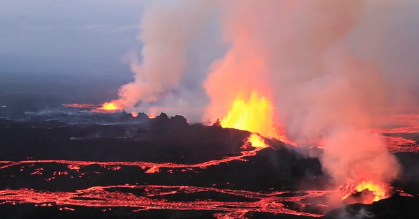
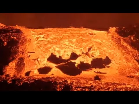
Nog wat verse lava om het verhaal te garneren =>

Ook de lava van de uitbarsting van vorig jaar is gewoon nog heet her en der =>

Over heet gesproken: zo'n vers lavaveld is echt onwaarschijnlijk heet. Op honderden meters afstand is de warmtestraling nog steeds intens. Vergelijkbaar met als je iets te dicht bij een groot kampvuur zit.
[ Bericht 1% gewijzigd door Puntenjager op 11-09-2022 02:36:02 ]
I've got 99 problems, but a bitch ain't one.
quote:Glacial flood in Grímsvötn, Aviation Color Code raised to Yellow, Iceland
A new glacial flood started at Grímsvötn, a subglacial volcano under Vatnajökull, Iceland, on October 10, 2022, prompting authorities to raise the Aviation Color Code to Yellow and announce the State of Uncertainty.
Glacial flooding can trigger subglacial eruptions, which have been known to happen at Grímsvötn.
This is the most active volcano in Iceland with eruption intervals every 5 to 10 years. The last took place in 2011 and was quite large and powerful.
The ice sheet has receded by almost 3 m (10 feet) several days before the flood started and by 7 m (23 feet) on October 12, the Icelandic Met Office (IMO) reports.1 If the Grímsvötn subglacial lake drains completely, the ice shelf can likely sink by some 10 – 15 m (33 – 50 feet) in total.
The flow is currently at 300 m3/s so IMO predicts that the maximum flow out of the lakes will be late Thursday, October 13 or Friday.
Graph showing how much the ice sheet has receded since the beginning of October this year
Graph showing how much the ice sheet has receded since the beginning of October this year. Credit: IMO
It can be calculated that it takes about 24 hours for runoff water to flow under the Skeiðarjökull glacier from Grímsvötn and down to the course of the Gígjukvíslar by Highway 1. Going forward, it is calculated that the maximum flow out of the lakes will be around 500 m3/s.
It is likely that the flow at the bridge over Gígjukvísl will be less than out of the lakes themselves due to the attenuation of the runoff in the reservoirs in front of Skeiðarjökull. The flow at the bridge in this run will therefore be equal to the high summer flow and will not have any effect on structures such as roads and bridges.
There is little or no seismic activity in the volcano and no volcanic eruptions have been detected.
The last flood from Grímsvötn was in December last year, so it’s been a short time since the last flood.
There are examples of volcanic eruptions in Grímsvötn coinciding with glacial floods. It is likely that the sudden pressure relief due to decreasing water level can trigger eruptions. The last time such a scenario happened was in 2004, and before that in 1934 and 1922.
However, Grímsvötn has much more often had floods without an eruption.
Two things need to happen for an eruption to start: pressure relief has to be enough to “trigger” and wake up the volcano, and magma pressure within the volcano has to be enough to set off an eruption, but there is uncertainty about both aspects.
The chance of an eruption will quickly decrease after the flood.
The last eruption at this volcano occurred in 2011 CE – May 21 to 28, 2011 (VEI 4) – and emitted about 0.8 km3 (0.20 mi3) of basaltic tephra (bulk volume).
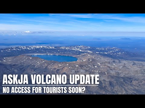
Askja
Ármann Höskuldsson, a volcanologist and geochemist at the University of Iceland’s Institute of Earth Sciences, told Fréttablaðið on Wednesday that the Askja volcano was likely to erupt “sooner rather than later.” Temperature patterns at the surface of Lake Askja suggest that geothermal flux had significantly increased over the past few weeks.
https://www.icelandreview(...)r-rather-than-later/
[ Bericht 2% gewijzigd door #ANONIEM op 06-03-2023 07:32:39 ]


Eindelijk was ik weer net iets eerder dan jouquote:
Katla naar alert level geel, na meerdere lichte aardbevingen
quote:Strong earthquake swarm in Mýrdalsjökull
At 9.41 am this morning, a strong earthquake swarm started in Mýrdalsjökull glacier. First, but not conclusively verified, results show that three quakes have occurred above magnitude 4.4, with magnitudes 4.5, 4.3 and 4.2.
There have been about seven quakes ranging in magnitude from 3 to 4, the Icelandic Met Office reported.
No harmonic tremors have been detected.
The quakes are located in the center of the caldera. A flight alert colour code for Katla has been put on yellow.

quote:Activity summary:
Yesterday at 09:41 a sudden and intense seismic swarm started in Katla with three earthquakes of magnitude larger than 4 located in the middle of the caldera. Since yesterday afternoon the activity has decreased significantly and no other geophysical measurements show indicators of significant changes or anomalies. Katla is currently back to known background activity and the colour code is changed to green.

quote:Earthquakes Rocking Reykjanes Pointing To Another Eruption
A magnitude 4.0 earthquake woke late sleepers in central Reykjavík at 8:21 this morning. But, it’s residents of the Reykjanes peninsula that are likely a little worse for wear this morning, waking up from a long night of back to back quakes.
A tally from the Icelandic Met Office lists well over 1000 quakes that have struck the peninsula over the past days, with 21 larger than a magnitude of 3.0. The return of constant rumbling has geologists and volcanologists watching the area closely, with RÚV reporting that an eruption could be imminent at Fagradalsfjall.
The area last erupted at Geldingadalir in 2021 and Meradalir in 2022.
Volcanologist Þorvaldur Þórðarson told the radio station Bylgjan on Monday the land has been inflating under the entirety of the Reykjanes peninsula in recent weeks, signalling rising lava under the surface.
The rising land throughout the entirety of the peninsula – not just under the previous eruptions sites – also signals that the entire peninsula could be one giant active volcano rather than a chain of smaller volcanoes, as previously believed. In theory, that means that lava could begin erupting from any place on the Reykjanes peninsula.
Stel dat dat kreng uitbarst, op wat voor schaal aan gevolgen moeten we dan denken? Wat hinder voor het vliegverkeer, of massa-evacuaties en/of (lokale) klimatologische ellende?
blablablabla
Liever deze, dan b.v. de Katla.quote:
Stel dat dat kreng uitbarst, op wat voor schaal aan gevolgen moeten we dan denken? Wat hinder voor het vliegverkeer, of massa-evacuaties en/of (lokale) klimatologische ellende?
Deze is vorig jaar ook al uitgebarsten..
UPDATE 14:30
Vandaag al 6 bevingen van 4+. De meningen over het moment van uitbarsten liggen tussen "deze zomer" en elk moment (in dagen).
De enige camera die richting actief gebied staat is deze: Fagradalsfjall
Vanaf gisteravond weer honderden aardbevingen op Reykjanes, noordoostelijk van Geldingadalir (vorige uitbarstingslocatie), zuidwestelijk van Keilir.
Enkelen hadden vannacht een kracht van 3+, en rond 04:30 één van 4+.
Het lijkt erop, dat we hier weer te maken hebben met magmaverplaatsingen naar de oppervlakte.
Het is niet bekend of de magma ook daadwerkelijk de oppervlakte gaat bereiken.
De situatie wordt nauwlettend in de gaten gehouden.
https://www.ijsland-enzo.(...)pagina.asp?tabsel=0#
Ah ja dat vroeg ik me af of in augustus het dezelfde betrof. Zat dit verhaal te lezen laatst, wat een horrorgevolgen een grootschalige uitbarsting kan hebben wereldwijdquote:Op woensdag 5 juli 2023 16:04 schreef aloa het volgende:
[..]
Liever deze, dan b.v. de Katla.
Deze is vorig jaar ook al uitgebarsten..
blablablabla
Gelukkig is de naam van deze nog een beetje uit te spreken, dat is wel anders met andere vulkanen op IJsland.

quote:Earthquake swarm close to Eldey and Eldeyjarboða á Reykjanes ridge
It seems that sometimes in the last 24 hours an earthquake swarm started close to Eldey and Eldeyjarboða on the Reykjanes ridge. Largest earthquakes seems to be around Mw3,2 to Mw3,7 or in around that magnitude. Since it is close to impossible to see the earthquakes on the map in all the activity that is happening close to Keilir mountain.
Green stars out in the ocean is the activity on the Reykjanes ridge. There's a lot of activity on this map and the whole thing is a mess to read.
Heavy earthquake activity on the Reykjanes peninsula and Reykjanes ridge. Copyright of this image belongs to Icelandic Met Office.
I don’t know if this earthquake swarm is connected to what is happening in Fagradalsfjall mountain and Keilir mountain. It seems unlikely, but this activity might have been triggered by that earthquake swarm. What is going on there is unclear. Since this is out in the ocean.

Eldey is nu ook verhoogd naar geelquote:
Alert level voor Fagradalsfjall verhoogt naar oranje
Spann0nd. 
Dat wordt weer hele dagen live cam staren.
[ Bericht 60% gewijzigd door DemonRage op 09-07-2023 10:59:08 ]
Dat wordt weer hele dagen live cam staren.


[ Bericht 60% gewijzigd door DemonRage op 09-07-2023 10:59:08 ]

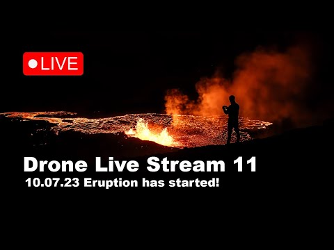
Die mensen daar zo dichtbij, echt link.
De waarheid in iemands hoofd is vaak onbuigzamer dan het sterkste staal.


NOS is ook wakker 
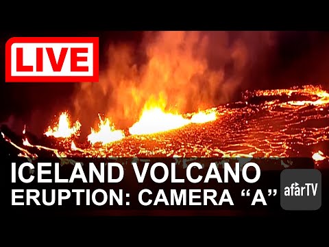
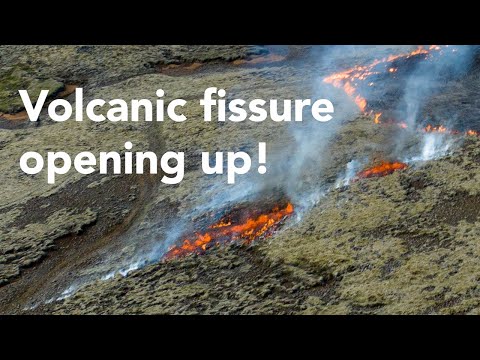
quote:Vulkaan uitgebarsten in IJsland, lava over breedte van honderden meters uitgespuwd
In IJsland is voor het derde jaar op rij een vulkaan uitgebarsten. De uitbarsting is opnieuw in het zuidwesten van het land, in onbewoond gebied in een vallei zo'n 30 kilometer van de hoofdstad Reykjavik.
Gemiddeld is er in IJsland elke vier à vijf jaar een vulkaanuitbarsting. Het land ligt op een vulkanische hotspot in de noordelijke Atlantische Oceaan.
De vulkaan Fagradalsfjall spuwt sinds gistermiddag lava, maar geen aswolken, meldt de meteorologische dienst van IJsland. Gevolgen voor het vliegverkeer zijn er niet. Wel zijn er dichte rookwolken, veroorzaakt door de gloeiende lava.
De lava wordt over een breedte van 200 meter uitgespuwd "als een reeks fonteinen" op de flanken van de berg, zegt de dienst, maar afgewacht moet worden hoe het zich ontwikkelt. Het is vooralsnog een kleine uitbarsting.
De Fagradalsfjall is geen klassieke kegelvormige berg met een gat erin. De lava komt uit een 900 meter lange spleet in de aarde. Deze vorm leidt meestal niet tot grote aswolken.
Er werd al rekening gehouden met de uitbarsting, omdat er duizenden lichte aardbevingen waren geregistreerd in het gebied, met een piek van 5,2 op zondagavond.
De twee eerdere uitbarstingen in de omgeving leidden niet tot schade of overlast. In 2021 hield de lavastroom enkele maanden aan. De spectaculaire beelden trokken honderdduizenden mensen. Nieuwsgierigen worden nu gewaarschuwd niet te gaan kijken, omdat er giftige gassen vrijkomen.
In 2010 was de laatste grote uitbarsting in IJsland, toen de vulkaan Eyjafjallajökull grote aswolken spuwde. Dat leidde tot een dagenlange chaos in het internationale vliegverkeer. Meer dan 100.000 vluchten bleven aan de grond en vele miljoenen passagiers strandden.
Straks de Katla ook nog.quote:
[ twitter ]
Zou er een kans zijn dat het op twee plaatsen los gaat?
Dan breekt heel IJsland in twee stukken en ligt het Europese vliegverkeer maanden stilquote:
Weg zomervakanties
Hij gaat een keer de lucht in.quote:
[..]
Dan breekt heel IJsland in twee stukken en ligt het Europese vliegverkeer maanden stil
Weg zomervakanties
quote:Volcano in Iceland spewing toxic gas but eruption slowing
COPENHAGEN/OSLO, July 11 (Reuters) - A volcanic eruption in Iceland close to the capital Reykjavik is slowing, experts said on Tuesday, hours after officials had warned it was spewing out "life-threatening toxic gas".
Icelandic police restricted access to the volcano and residents of the Reykjanes peninsula were encouraged to shut windows and switch off ventilation, the department of civil protection and emergency management said late on Monday.
Advertisement · Scroll to continue
The Icelandic Met Office, Vedur, said on Tuesday morning that gas pollution was high and dangerous around the eruption, some 60 km (37 miles) from the capital, and pollution was likely in Reykjanes and Reykjavik.
However, air quality was still considered "very good" or "good" in the Reykjavik area on Tuesday, according to the Environmental Agency's website.
Tuesday's footage of the eruption showed that the fissure had shortened, lava flow had slowed and the gas plume was smaller, Magnus Tumi Gudmundsson, professor of geophysics at the University of Iceland, told the Icelandic broadcaster RUV.
Advertisement · Scroll to continue
"This has become a small eruption, which is very good news," he said, adding it was still impossible to assess how long it would last.
"In all likelihood it won't be big, it can certainly last a long time, but luckily we're not looking at a continuation of what we saw in the first few hours," he said.
The eruption follows intense seismic activity over the past few days and is classified as a fissure eruption, which does not usually result in large explosions or a significant amount of ash in the stratosphere, the Icelandic government said in a statement late on Monday.

Groot gedeelte van de vulkaan is vannacht ingestort. Hierdoor stroomt de lava nu via een andere kant, dan voorheen.
Spectaculaire beelden wel
Spectaculaire beelden wel


Men verwacht mogelijk ook een uitbarsting van de Askja. De vulkaan stijgt 3 cm per maand en vult zich met magma.
Zou een gigantisch probleem kunnen worden. De autoriteiten willen het gebied nu waarschijnlijk gaan sluiten ivm het risico voor de mensen die de vulkaan bezoeken. Mocht deze uitbarsten en er zijn nog mensen, dan maken die zeer waarschijnlijk geen kans.
Zou een gigantisch probleem kunnen worden. De autoriteiten willen het gebied nu waarschijnlijk gaan sluiten ivm het risico voor de mensen die de vulkaan bezoeken. Mocht deze uitbarsten en er zijn nog mensen, dan maken die zeer waarschijnlijk geen kans.
Er zijn nog wel lichte aardbevingen, tussen de 8 en 15 km diepte. Zwaarste vandaag was 2.0
quote:En dan blijkt dit weekeinde de uitbarsting tot een einde te zijn gekomen, niet officieel, want daar zijn speciale voorwaarden voor/afspraken over, maar voorlopig houden we het op een vredig einde.
Het is echter niet uit te sluiten dat de activiteit verplaatst is en er ergens anders magma ontstaat.
https://www.ijsland-enzo.(...)spagina.asp?tabsel=0


A seismic swarm started north of Grindavík last night
No evidence of magmatic intrusion around Þorbjörn and Grindavík
25.10.2023
Last night an intense earthquake swarm started near Svartsengi, north of Grindavík. Over 1000 earthquakes have been detected there since midnight and the swarm is still ongoing. The largest earthquakes detected are M3.9 at 5:35 UTC and M4.5 at 8:18 UTC. Both of those earthquakes originated at around 5 km depth. Latest deformation data collected from several stations around the Þorbjörn/Grindavík area do not show significant changes correlated with the ongoing seismic activity. In light of the data currently available, this seismicity is interpreted to be likely triggered by the stress changes related to previous intrusive activity on the peninsula. There are currently no indications of magma migration beneath the Þorbjörn/Grindavík area, but the situation might change anytime, and it might evolve over a short time from hours to days. As reported in September a magmatic intrusion is currently ongoing beneath Fagradalsfjall.
Staff of IMO continues to monitor the area closely and interpret newest data as it becomes available.
https://en.vedur.is/about(...)grindavik-last-night

Er zijn duidelijke aanwijzingen dat er op diepte magma beweging is. De grond in dit gebied is aan het stijgen.
Nog geen magma op mindere diepte, maar dat kan een kwestie van tijd zijn. Door alle aardbevingen (7000 inmiddels) bestaat de kans dat de magma wel een snellere weg omhoog vindt.
Nog geen magma op mindere diepte, maar dat kan een kwestie van tijd zijn. Door alle aardbevingen (7000 inmiddels) bestaat de kans dat de magma wel een snellere weg omhoog vindt.
quote:Ground uplift detected northwest of Þorbjörn
New data reveals a complex process of magma movements on the Reykjanes Peninsula
28.10.2023
Updated 28th of October at 1:30pm
The latest cGPS measurements, along with a newly acquired InSAR image over Reykjanes Peninsula, reveals a clear sign of ground uplift, centred around Svartsengi. This uplift signal began at some point on 27 October, and it reflects a pressure increase that is probably caused by a magmatic intrusion at depth. The centre of the uplift signal is around 1.5 km northwest of Þorbjörn, close to the Blue Lagoon. In 2020 and 2022, similar uplift signals were detected in the same area and with similar geometry. This is now the fifth inflation event in the area. From an initial assessment, the ongoing uplift signal is occurring more rapidly than before. Presently, there are no indications of magma moving at shallower depth. However, the situation may evolve rapidly. For instance, significant fracturing has occurred in the Svartsengi area due to triggered seismicity in recent days. Such fracturing could allow magma to find pathways to shallower depth.
Overall, the latest deformation results from the Reykjanes Peninsula show a complex, ongoing process of magma movements in the earth's crust. These processes are affecting a wide area, including Fagradalsfjall (where long-term inflation continues), east of Festarfjall (where the deformation seems to have stopped), and – in the last 24 hours – an area close to Svartsengi shows inflation.
The seismic swarm that began on 25 October north of Grindavík has resulted in over 7.000 earthquakes. The level of earthquake has reduced considerably, although the swarm is still ongoing, meaning that felt earthquakes are still likely.
Geophysical modelling is underway today to determine the depth and size of the uplift source close to Svartsengi. An additional satellite radar image will be available from Reykjanes Peninsula on 29 October. This image should provide an even closer insight into the recent magma movements and deformation pattens on the peninsula.
https://en.vedur.is/about(...)grindavik-last-night
quote:30-10-2023 | 14:00 AARDBEVINGEN REYKJANES
De aardbevingsgolf tussen Blue Lagoon en Grindavík houdt aan, ook één van 4.5 om 12:00
Verontrustend is het, dat de grond ter plekke 3 cm is gerezen in 24 uur. Dit is meer dan bij de vorige 3 uitbarstingen.
Blue Lagoon heeft dagelijks overleg met de betrokken autoriteiten over eventueel te nemen maatregelen.
Uiteraard geldt datzelfde voor Grindavík.
https://www.ijsland-enzo.(...)spagina.asp?tabsel=0
quote:Updated 30th of October at 11:30am
The Sentinel satellite data expected to be received yesterday has not arrived yet, however the cGPS data in the area around Svartensgi and Þorbjörn show that the deformation is still ongoing. The deformation rate since the beginning of this intrusive event has been slightly decreasing over time. Preliminary deformation model results suggest the average depth, where the magmatic instrusion is occurring, is about 4 km.
Over the past 24 hours about 1300 earthquakes have been automatically detected on the Reykjanes Peninsula. Most of this seismicity is located at a depth between 2-4 km. The largest earthquake had a magnitude M2.7 on the 29 October at 11:40UTC.
Scientists from the Icelandic Meteorological Office are undertaking additional surface measurements in the area, including geochemical observations. Regular communication is maintained between IMO, HS-Orka and the Civil Protection while this unrest continues.
quote:The Blue Lagoon (IJslands: Bláa Lónið; "de blauwe lagune") is een geothermisch bad in de buurt van Grindavík, zuidwest IJsland.
Het bad, of eigenlijk een kunstmatig meer, ligt in een oud met mossen begroeid lavaveld. Het water heeft een temperatuur van 39 graden Celsius en bevat ongeveer 2,5% zout. Het warme water is eigenlijk een bijproduct van de geothermische elektriciteitscentrale van Svartsengi. Het water is rijk aan mineralen, silicaten en blauwwieren die het een lichtblauwe, bijna opalescerende kleur geven. Het bad trekt veel mensen met de huidziekte psoriasis omdat het water een helende werking zou hebben. Het bad is een van de grootste toeristische trekpleisters van IJsland.
De lagune registreerde 1,3 miljoen bezoekers in 2017 tegen 919.000 bezoekers in 2015. Het bedrijf had een omzet van € 102 miljoen en een winst van € 31 miljoen in 2017. Het heeft meer dan 600 werknemers.
https://nl.wikipedia.org/wiki/Blue_Lagoon_(zwembad)
Even vertaald uit het Engels. De kans op een uitbarsting is zeer groot, de vraag is meer wanneer.
quote:Bijgewerkt op 2 november om 15.00 uur
GPS-gegevens van de afgelopen 24 uur geven aan dat de stijging zich in een vergelijkbaar tempo voortzet in het gebied ten noordwesten van de berg Þorbjörn. De aardbevingsactiviteit is vrij stabiel geweest, maar gisteren werden ongeveer 800 aardbevingen geregistreerd in het gebied rond Þorbjörn, en de grootste was M3.7 om 12:56 uur. Sinds middernacht vandaag zijn er ongeveer 400 aardbevingen in het gebied geregistreerd, waarvan de grootste om 09.51 uur M2.8 meet. Een meer gedetailleerde analyse van recente GPS-gegevens bevestigt dat zich een magma-indringing vormt op een diepte van 4-5 km onder het gebied ten noordwesten van Þorbjörn.
Het is belangrijk op te merken dat de seismische activiteit waarschijnlijk zal voortduren ten noordwesten van Þorbjörn, en dat aardbevingen boven M4.0 in bevolkte gebieden kunnen voorkomen. Ook kan de komende dagen getriggerde seismische activiteit worden verwacht, omdat het binnendringen van magma voor verhoogde spanningen in het gebied zorgt. Steenslag kan optreden na sterke aardbevingen, dus het is belangrijk om voorzichtig te zijn op steile hellingen.
https://en.vedur.is/about(...)grindavik-last-night


Blijven kijken dus. Live webcam:
https://www.livefromiceland.is/webcams/svartsengi
Wel mooi dat IJsland zo veel goede kwaliteit livestreams heeft.
Terwijl veel weerwebcam-sites over de wereld alleen een foto van het laatste kwartier ofzo laten zien.
https://www.livefromiceland.is/webcams/svartsengi
Wel mooi dat IJsland zo veel goede kwaliteit livestreams heeft.
Terwijl veel weerwebcam-sites over de wereld alleen een foto van het laatste kwartier ofzo laten zien.
Staat als achtergrond aan hier.quote:
Blijven kijken dus. Live webcam:
https://www.livefromiceland.is/webcams/svartsengi
Dat is een elektriciteitscentrale, Svartsengi geothermal power stationquote:
[..]
Wat is dat rechts op de stream dan? Lijkt toch wel magma ofzo?
Dat is de Blue Lagoon. Ze verwachten de uitbarsting zeg maar recht voor de camera, waar die weg loopt.quote:
[..]
Wat is dat rechts op de stream dan? Lijkt toch wel magma ofzo?
En wat is dat gele achterin rechts?quote:Op zondag 5 november 2023 18:37 schreef Houtenbeen het volgende:
[..]
Dat is een elektriciteitscentrale, Svartsengi geothermal power station
Dorpje Grindavik denk ikquote:
[..]
En wat is dat gele achterin rechts?