WKN Weer, Klimaat en Natuurrampen
Lees alles over het onstuimige weer op onze planeet, volg orkanen en tornado's, zie hoe vulkanen uitbarsten en hoe Moeder Aarde beeft bij een aardbeving. Alles over de verwoestende kracht van onze planeet en tal van andere natuurverschijnselen.


Fake winds!quote:Op dinsdag 4 juni 2019 15:04 schreef Nattekat het volgende:
[..]
Hij liegt. Of ik sta op een plek die aerodynamisch dusdanig is dat de wind van de andere kant komt.
Recht zo die gaat, braaf zo die heen.
Kreeg zelfs een pushmelding van de NOSquote:Code Oranjetwitter:KNMI twitterde op dinsdag 04-06-2019 om 14:55:34 Vanaf 18.00 #codeoranje in #Zeeland, #ZuidHolland en #NoordBrabant vanwege #onweersbuien. In de overige provincies geldt nog #codegeel. Houd onze weersverwachting in de gaten. #knmiwaarschuwing https://t.co/DXKDlnrpa7 reageer retweet
[ afbeelding ]
 Vanaf 18.00
Trotse Twentenaar
Je zal maar in Limburg wonen op dr grens met Brabant, heb je lekker code geel iov oranje.  Maar eigenlijk raar dat codes per provincie gaan...
Per Gemeente is ook weer lastigquote:Op dinsdag 4 juni 2019 15:14 schreef Kapitein_Schavuit het volgende:
Je zal maar in Limburg wonen op dr grens met Brabant, heb je lekker code geel iov oranje.
Het is zeer bepalend..quote:
Heeft de temperatuur vandaag nog veel effect op hoe hevig het gaat uitpakken?
“Rather than love, than money, than fame, give me truth.”

Buienradar +48 uur zetten dan zie je rond 2 uur in de nacht van woensdag op donderdag ook een flinke bak ellende!
DISCUSSION
.... France, Belgium, the Netherlands, Luxembourg and Germany ....
The approaching trough from the west will be associated with the south-southeasterly flow near the surface, and the veering wind profiles that all available NWP models forecast, will create a dangerous environment for any thunderstorm that will develop. Convective initiation is expected first in Central - NE France after 15z where the PBL mixing ratio is expected to reach values up to 11 g/kg and steep mid-level lapse rates will build large values of CAPE. MLCAPE is forecast to exceed 1.5 kJ/kg inside the level-2 area where more than 15 m/s of 0-3km bulk shear will be available. Storms will be able to quickly form supercells, travelling long distances and producing large hail, severe wind gusts and tornadoes.
The latest outputs of regional models provide different solutions for the convective mode that should be anticipated. If discrete supercells form in NE France and Belgium then the main threat will be large (or very large) hail and tornadoes. If supercells form bow echoes then widespread severe wind gusts will be the main threat.
Given the low predictability of the storm-mode of the storms translating towards Belgium and the Netherlands, it is difficult to exclude any threat. Nevertheless, the high low-level shear of veering winds which create more than 100-150 m2/s2 SREH0-1km and low LCLs, even below 1000 m, mostly inside the level-2 area will increase the probability of tornadogenesis. Convection will become elevated during the night and storms should start weakening before midnight while entering the North Sea.

las het net ja, klinkt aardigquote:
DISCUSSION
.... France, Belgium, the Netherlands, Luxembourg and Germany ....
The approaching trough from the west will be associated with the south-southeasterly flow near the surface, and the veering wind profiles that all available NWP models forecast, will create a dangerous environment for any thunderstorm that will develop. Convective initiation is expected first in Central - NE France after 15z where the PBL mixing ratio is expected to reach values up to 11 g/kg and steep mid-level lapse rates will build large values of CAPE. MLCAPE is forecast to exceed 1.5 kJ/kg inside the level-2 area where more than 15 m/s of 0-3km bulk shear will be available. Storms will be able to quickly form supercells, travelling long distances and producing large hail, severe wind gusts and tornadoes.
The latest outputs of regional models provide different solutions for the convective mode that should be anticipated. If discrete supercells form in NE France and Belgium then the main threat will be large (or very large) hail and tornadoes. If supercells form bow echoes then widespread severe wind gusts will be the main threat.
Given the low predictability of the storm-mode of the storms translating towards Belgium and the Netherlands, it is difficult to exclude any threat. Nevertheless, the high low-level shear of veering winds which create more than 100-150 m2/s2 SREH0-1km and low LCLs, even below 1000 m, mostly inside the level-2 area will increase the probability of tornadogenesis. Convection will become elevated during the night and storms should start weakening before midnight while entering the North Sea.

Onwedersgenot.quote:
|| FOK!Stok || tatatatatataatatatattaaaaapiediedieuwtididipieuwpidibididi She said I'll throw myself away pididididum They're just photos after all! || Den Helder || Winnaar VBL Wijndal-award 2020: beste AZ-user! || Mijn concertstatistieken ||

MS discussie op Estofexquote:At 13 UTC, scattered towering cumulus across the northern Pays de la Loire, Normandy and Hauts-de-France regions were developing below a cirrus deck. Within this region, low-level humidity has gradually risen and 17-18°C dew point temperatures are observed at 13 UTC. Storm initiation seems imminent in this region. Given the strong deep-layer shear, they may develop quickly into supercells or bowing structures.
Across the northern half of the MD regions, winds are easterly north of a diffuse warm front, and strong low-level directional shear is occurring and increasing. Any storm that develops in this regime has a marked potential to develop strong low-level rotation and become tornadic. That said, convective initiation seems more hesitant here. The region should be monitored close for storm development.
http://www.estofex.org/
Dat is de regen. Supercell komt erachteraan, dus juist goed.quote:
[ afbeelding ]
Noordzee heeft al genoeg water.
Na vandaag is de Noordzee brak.quote:
[ afbeelding ]
Noordzee heeft al genoeg water.
Oh snap m'n bier is op, gauw naar de supermarkt
Recht zo die gaat, braaf zo die heen.
Oke, lees nu dat de temperatuur eerst omlaag zal gaan en dan weer omhoog door het aankomende front.quote:
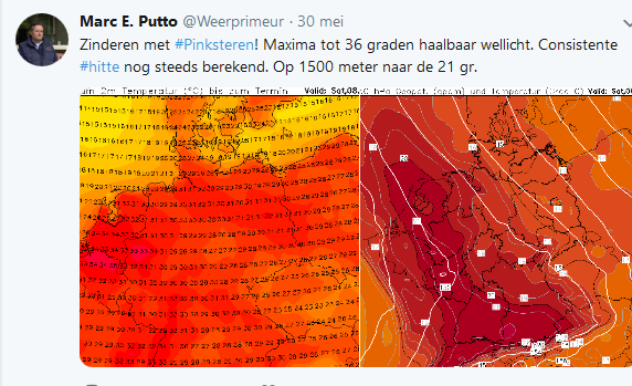
Dat is bijna een week oud?quote:
[ afbeelding ]
Hopelijk komt dit model niet uit

Wil je niet zulke enge dingen posten.quote:
[ afbeelding ]
Hopelijk komt dit model niet uit
Koel en donker bewaren