WKN Weer, Klimaat en Natuurrampen
Lees alles over het onstuimige weer op onze planeet, volg orkanen en tornado's, zie hoe vulkanen uitbarsten en hoe Moeder Aarde beeft bij een aardbeving. Alles over de verwoestende kracht van onze planeet en tal van andere natuurverschijnselen.


Boven Amsterdam. Wint waait zo hard dat raam stukje dicht moetquote:
Op woensdag 22 januari 2025 19:50 schreef Bugno3 het volgende:
Stukje Pelle, stukje Cannavaro, stukje Totti.
Stukje Pelle, stukje Cannavaro, stukje Totti.
Jaloersquote:
Maar gun het je wel hoor
Hier flitsen in de verte.
Zal je zien dat ik zo de ramen dicht moet doen wegens hard onweer.
IT'S GREYSIE IT'S PARTY
Ga dan ook niet in de lucht hangenquote:Op woensdag 8 augustus 2018 00:02 schreef Pisces29 het volgende:
[..]
Boven Amsterdam. Wint waait zo hard dat raam stukje dicht moetik twijfel of het regent. Heel zacht.
100.000 katjes
Fuck the EBU!
Fuck the EBU!
De koele vlek die in onze regio hing lijkt naar het noorden te trekken. In Zwolle ook van 21 naar bijna 24 inmiddels.quote:
Twente van 21 naar 25 graden in 10 minuten
Meteorologische rollercoasterquote:
Twente van 21 naar 25 graden in 10 minuten
IT'S GREYSIE IT'S PARTY
Oeh ik zag een flits 
Op maandag 24 augustus 2015 11:34 schreef Yasmin23 het volgende:
Als je maar genoeg moeite doet past alles.
_____
TV / Het post-apocalyptische/dystopische film topic
Als je maar genoeg moeite doet past alles.
_____
TV / Het post-apocalyptische/dystopische film topic

Deze zomer.quote:
Twente van 21 naar 25 graden in 10 minuten
En de wind is GONE. Was weer 5 minuten. Maar denk dat het straks wel los gaat als radar komt.
Op woensdag 22 januari 2025 19:50 schreef Bugno3 het volgende:
Stukje Pelle, stukje Cannavaro, stukje Totti.
Stukje Pelle, stukje Cannavaro, stukje Totti.
Ook een mentale voor sommigenquote:
Op woensdag 22 januari 2025 19:50 schreef Bugno3 het volgende:
Stukje Pelle, stukje Cannavaro, stukje Totti.
Stukje Pelle, stukje Cannavaro, stukje Totti.
idd.. en flitsen boven zeequote:Op woensdag 8 augustus 2018 00:05 schreef Klaphark het volgende:
Boven Alkmaar nu een flink windje ineens.
"Light thinks it travels faster than anything. It doesn't. For wherever light travels it finds darkness has got there first and is waiting for it."
Genietenquote:
En in het oosten gaat de hittegolf morgen gewoon nog door
I solemnly swear i'm up to no good
En overmorgen..quote:
Heel misschien vrijdag nét onder de 25.. maar daarna er weer dik boven
Als vrijdag wel gehaald wordt, is dat dag 30 van regionale hittegolf
so get yourself a car and drive it all alone
get yourself a car and ride it on the wind
get yourself a car and drive it all alone
get yourself a car and ride it on the wind yea
get yourself a car and ride it on the wind
get yourself a car and drive it all alone
get yourself a car and ride it on the wind yea
Mijn stemming was al aardig omdat nog één nacht maar werd nog iets beter toen ik dit net zag. Ben benieuwdquote:

IT'S GREYSIE IT'S PARTY
Ik ook, met het risico dat ik straks wakker wordt van een keiharde klap omdat er een raam of deur dicht is geklapt.quote:
Ik ga toch maar proberen te slapen. Tegen beter weten in.

RIP.quote:
[..]
Mijn stemming was al aardig omdat nog één nacht maar werd nog iets beter toen ik dit net zag. Ben benieuwd
[ afbeelding ]
Koel en donker bewaren
Al mijn planten aan diggelen als het weer met zoveel ellende naar beneden komtquote:
[..]
Mijn stemming was al aardig omdat nog één nacht maar werd nog iets beter toen ik dit net zag. Ben benieuwd
[ afbeelding ]
Op woensdag 22 januari 2025 19:50 schreef Bugno3 het volgende:
Stukje Pelle, stukje Cannavaro, stukje Totti.
Stukje Pelle, stukje Cannavaro, stukje Totti.
Estofex komt ook al met een voorwaarschuwing voor Donderdag/vrijdag
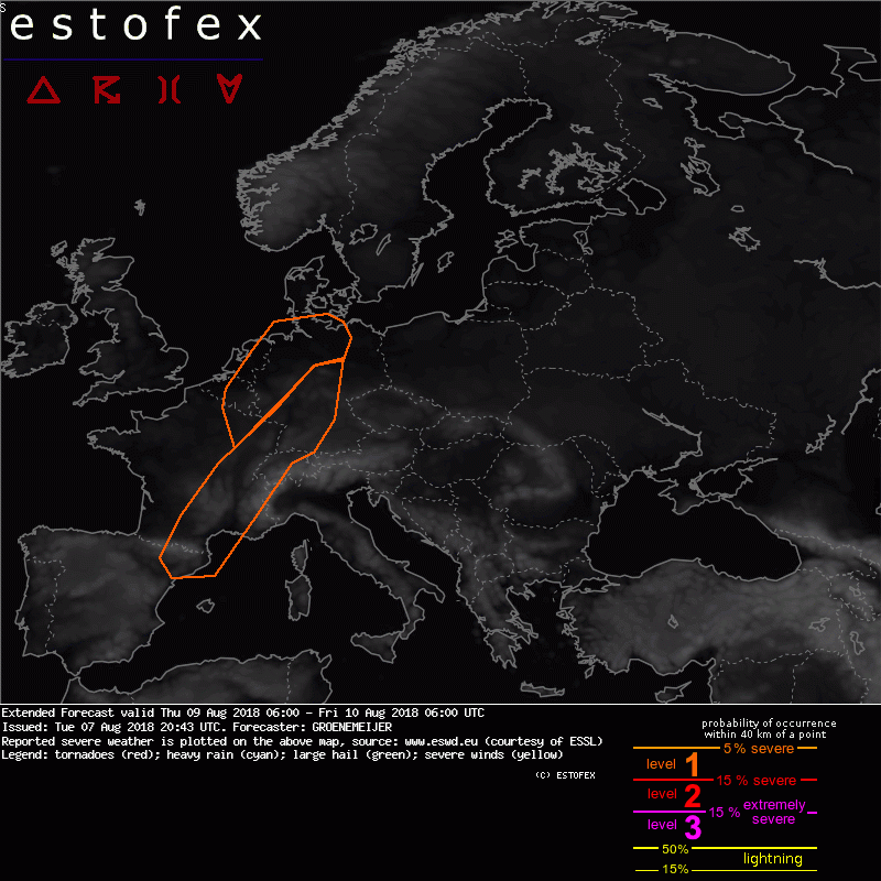
quote:Western Europe...
A developing frontal wave is expected to move across France and the Benelux during the day and evening while the associated surface low deepens. The wave develops ahead of an approaching trough across Western continental Europe under a south-southwesterly 30 m/s mid/upper jet.
The warm sector of the wave is expected to be moderately unstable with high low-level humidity in vicinity of the frontal zone. Strong shear is expected to exist across the warm sector, with long low-level hodographs projected ahead of the low near the warm front. Near the warm and cold fronts, organized storms including supercells are expected to develop along with disorganized clustered activity.
Especially ahead of the low across the northern area, low-level shear suggests a risk for a few tornadoes will develop along with a risk of damaging winds, heavy rainfall and large hail. Across the southern area, severe storms are forecast to develop along the eastward-moving cold front with large hail, severe winds and flash floods being the main risks.
Het waait weer alsof iemand een bladblazer bij het raam houdt
Op woensdag 22 januari 2025 19:50 schreef Bugno3 het volgende:
Stukje Pelle, stukje Cannavaro, stukje Totti.
Stukje Pelle, stukje Cannavaro, stukje Totti.