WKN Weer, Klimaat en Natuurrampen
Lees alles over het onstuimige weer op onze planeet, volg orkanen en tornado's, zie hoe vulkanen uitbarsten en hoe Moeder Aarde beeft bij een aardbeving. Alles over de verwoestende kracht van onze planeet en tal van andere natuurverschijnselen.


Topic over Mangkhut is geopend, maar kan iemand een h in de titel voegen?quote:Op zondag 9 september 2018 12:44 schreef Frutsel het volgende:
Kan iemand aub eigen topics maken voor mengkut en isaac?
Ben morgen pas weer meer online
WKN / Tyfoon Mangkut in de richting van Guam, daarna Taiwan/Fillipijnen?
You don't need a weatherman to know which way the wind blows.
---------------------------------------------------------------------------------------------------------------------------------------------
Album top 100 2024
---------------------------------------------------------------------------------------------------------------------------------------------
Album top 100 2024
Van bijna dood tot olympiër:
Nou vooruitquote:
[..]
Topic over Mangkhut is geopend, maar kan iemand een h in de titel voegen?
WKN / Tyfoon Mangkhut in de richting van Guam, daarna Taiwan/Fillipijnen?
Van bijna dood op weg naar de Olympische Spelen, tot olympiër in 2026? Elk beetje hulp wordt bijzonder gewaardeerd!
https://www.gofundme.com/(...)he-spelen-na-ongeval
https://www.gofundme.com/(...)he-spelen-na-ongeval

Topquote:
[..]
Topic over Mangkhut is geopend, maar kan iemand een h in de titel voegen?
WKN / Tyfoon Mangkhut in de richting van Guam, daarna Taiwan/Fillipijnen?


10-40% voor gebied in de Golfregio, mogelijk op weg naar Texas/Mexico
[ Bericht 26% gewijzigd door Frutsel op 10-09-2018 14:08:02 ]

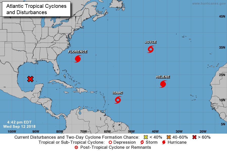
En dan is Isaac nu ook al een orkaan.quote:
You don't need a weatherman to know which way the wind blows.
---------------------------------------------------------------------------------------------------------------------------------------------
Album top 100 2024
---------------------------------------------------------------------------------------------------------------------------------------------
Album top 100 2024
jep...daarom zijn alle stormen op dat plaatje "dicht"quote:
[..]
En dan is Isaac nu ook al een orkaan.
een tropische storm wordt volgens mij anders weergegeven
Bij de NOAA wel (dan is een TS open), maar op dit plaatje zijn ze allemaal dicht, onafhankelijk of het een depressie, storm of een orkaan/tyfoon is (Isaac staat nog als TS, tropische storm dus).quote:
[..]
jep...daarom zijn alle stormen op dat plaatje "dicht"
een tropische storm wordt volgens mij anders weergegeven
You don't need a weatherman to know which way the wind blows.
---------------------------------------------------------------------------------------------------------------------------------------------
Album top 100 2024
---------------------------------------------------------------------------------------------------------------------------------------------
Album top 100 2024
Voor mijn gevoel was dat bij Wunderground nooit zoquote:
[..]
Bij de NOAA wel (dan is een TS open), maar op dit plaatje zijn ze allemaal dicht, onafhankelijk of het een depressie, storm of een orkaan/tyfoon is (Isaac staat nog als TS, tropische storm dus).
Maar zie dat het inderdaad nu zo staat
Onder Jamaica door richting Nicaragua ofzo... althans, dat is op dit moment de verwachting.quote:
Het zal bepalend zijn of Isaac de "vijandige" weersomstandigheden kan overleven.
Zie ook:
WKN / Orkaan Isaac op weg naar de Caribbean
Ah dank je.quote:
[..]
Onder Jamaica door richting Nicaragua ofzo... althans, dat is op dit moment de verwachting.
Het zal bepalend zijn of Isaac de "vijandige" weersomstandigheden kan overleven.
Zie ook:
WKN / Orkaan Isaac op weg naar de Caribbean
Altijd heel bijzonder hoe dat vanuit de ruimte is te zien.
Dag jongens tot ziens, tot in betere tijden.
twitter:philklotzbach twitterde op maandag 10-09-2018 om 21:05:40 #Hurricane #Florence has now generated more Accumulated Cyclone Energy than the first five named storms of the 2018 Atlantic #hurricane season combined. https://t.co/xv5YMauby2 reageer retweet


Helene richting Europa?
PVDA-PTB lid. Sanders supporter. Student psychologie. Interesse voor films, sport, geschiedenis, multimedia, wereldpolitiek, geologie en het weer.
Valt onmogelijk te zeggen omdat er mogelijke wisselwerking met Florence zal zijn.quote:
PVDA-PTB lid. Sanders supporter. Student psychologie. Interesse voor films, sport, geschiedenis, multimedia, wereldpolitiek, geologie en het weer.
Als dit gaat gebeuren zal er veel warmte op transport worden gezet richting onze contreien!quote:
[ afbeelding ]
Helene richting Europa?
''Aquila non capit muscas.''
Zou best aan land kunnen komen hoor... Iberisch schiereiland bijvoorbeeld... Gebeurt niet vaker, maar gaat vaker gebeuren in de toekomst, en het is al gebeurd 1 keer in de 18e eeuw en 1 keer in de 19e eeuw en al 1 keer in de 21ste eeuw (maar dan als tropische depressie)
In 1842

In 1842
En dan deze in Portugal in 1724quote:In late October, a highly unusual tropical cyclone formed in the far eastern Atlantic, first detected to the southwest of Madeira on October 24.[4] On October 26, a ship near Madeira recorded a barometric pressure of 965 mb (28.5 inHg), suggesting a hurricane of Category 2 intensity.[40] The hurricane passed just north of Madeira on October 27, producing heavy damage in Funchal. After brushing the northwestern coast of Morocco on the night of October 28–29,[41] the hurricane moved ashore over southwestern Spain and likely became extratropical shortly thereafter. As a result of the extratropical transition, damaging winds extended far from the storm center and affected much of inland Spain.[42] Dozens of ships, including three belonging to the Spanish Navy, were lost or severely damaged in the storm. Two bridges were washed away in Cádiz and homes were destroyed in Seville.[41][43] Hurricane-force winds reached as far inland as Madrid, and thousands of trees were uprooted in the province of Badajoz.[44] This storm serves as an important historical analogue for Hurricane Vince, which followed a similar course in October 2005.[45]
quote:November 18–19, 1724 – One of the most destructive storms ever experienced in Portugal since the early 17th century,[7] caused damage to the east coast of Madeira and central and northern Portugal. (There is some conjecture whether this storm was a tropical system such as Hurricane Vince in 2005 which impacted Europe).[8]
PVDA-PTB lid. Sanders supporter. Student psychologie. Interesse voor films, sport, geschiedenis, multimedia, wereldpolitiek, geologie en het weer.
Dan gaat het tropisch worden.quote:
[..]
Als dit gaat gebeuren zal er veel warmte op transport worden gezet richting onze contreien!.
 Op
Op 

Het zal geen categorie 5 worden vermoed ik maar als ze als categorie 4 aan land komt dan valt het niet mee... zal heel veel schade, wateroverlast zijn. Zullen vermoedelijk ook doden vallenquote:
Zal Florence gaan meevallen of niet?
vaak een ietwat onstuimig weertype... niet koud... wel wisselvallig, wind en buien... nog even afwachtenquote:
[..]
Krijgen wij hier nu ook wat van mee in de zin van slecht weer?
De Azoren krijgen zaterdag dan wel te maken met Helene, maar dan als stevige tropische storm.quote:
Huidige trend atmosf. CO2 Mauna Loa: 411 ppm ,10 jaar geleden: 387 ppm , 25 jaar geleden: 358 ppm

Orkanen gebruiken warme lucht en warm zeewater als 'brandstof'. Dat is grotendeels alleen rond de evenaar te vinden.quote:Op woensdag 12 september 2018 16:17 schreef Sloggi het volgende:
[..]
Hoe komt het dat al die dingen boven de evenaar ontstaan?
Eigenlijk ontstaan ze nooit op de evenaar en zelden tussen 5 graden noorderbreedte en 5 graden zuiderbreedte maar altijd daarboven of onder.

Stilte voor de storm, live cam:
Kust voor Jacksonville NC.
Hang Ten

Kust voor Jacksonville NC.
Hang Ten
How do we turn this world-class fuck-up into a world-class learning experience?

Die orkaan bij de Filipijnen gaat ook lekker.
|| FOK!Stok || tatatatatataatatatattaaaaapiediedieuwtididipieuwpidibididi She said I'll throw myself away pididididum They're just photos after all! || Den Helder || Winnaar VBL Wijndal-award 2020: beste AZ-user! || Mijn concertstatistieken ||
De amerikaanse vlag begeeft het al. Zet je geluid zachter voor je hem aanzet anders blaast de orkaan uit je woofers.
[ Bericht 3% gewijzigd door thesiren.nl op 13-09-2018 21:26:39 ]

[ Bericht 3% gewijzigd door thesiren.nl op 13-09-2018 21:26:39 ]


Van bijna dood tot olympiër:
Dat is inmiddels Kirk, die als tropische storm richting de Caraïben gaat.quote:
[ afbeelding ]
Joekel van een wave die nu van Afrika af komt zeg
Van bijna dood op weg naar de Olympische Spelen, tot olympiër in 2026? Elk beetje hulp wordt bijzonder gewaardeerd!
https://www.gofundme.com/(...)he-spelen-na-ongeval
https://www.gofundme.com/(...)he-spelen-na-ongeval

Supertyfoon Trami op weg naar Taiwan/Japan
WKN / Tyfoon Trami richting Taiwan en Japanse eilanden
[ Bericht 18% gewijzigd door Frutsel op 24-09-2018 09:48:27 ]
Kirk gaat het niet overleven... "Resistance is Futile"...quote:
[..]
Dat is inmiddels Kirk, die als tropische storm richting de Caraïben gaat.
Condities zijn niet zo best nu


In de East-Pacific zwerft op dit moment Orkaan Rosa
Gaat nog een "major hurricane" worden... geen bedreiging voor land vooralsnog

Gaat nog een "major hurricane" worden... geen bedreiging voor land vooralsnog
quote:
Krijgt Griekenland te maken met een orkaan?
[ afbeelding ]
quote:Exceptionally rare first september tropical cyclone since 1950
Tropical Cyclone "Liua" formed in the Southwest Pacific Ocean on September 26, 2018, as the first named storm of the 2018/19 South Pacific tropical cyclone season. This is the first tropical cyclone to form in the SW Pacific during the month of September since Tropical Cyclone 02P on September 12, 1950, or in 68 years. The season officially starts on November 1 and ends April 30.
NIWA's Chris Brandolino said Liua comes even before forecasters have put together their cyclone outlook for the region, due to be published next month.
"It is very unusual," Brandolino said. "In fact, this is the first tropical cyclone to form in the month of September going back to 1950. It is certainly unusual."
Steve Meke of RSMC Fiji said September cyclones are extremely unusual, adding that conditions in the whole region are months ahead of usual.
Liua formed from a disturbance located in the Australian region basin. It crossed into the South Pacific basin on September 26, and was designated as Tropical Depression 01F by RSMC Nadi. Late on September 26, the storm intensified into a tropical cyclone and was given the name Liua.
The cyclone is currently located over the Solomon's Makira Island and is forecast to develop into a Category 2 (of 5) storm on the Australian tropical cyclone intensity scale (89 - 117 km/h / 55 - 73 mph).
At 03:00 UTC on September 27, the center of Tropical Cyclone "Liua" was located approximately 970 km (600 miles) northwest of Port Vila, Vanuatu and has tracked SW at 15 km/h (9 mph) over the past six hours. The storm had maximum 1-minute sustained winds of 65 km/h (52 mph).
The environmental analysis shows the cyclone is located in an unfavorable area of increasing vertical wind shear, although strong poleward outflow is helping to maintain convection and sea surface temperatures are currently favorable.
Liua is forecast to marginally intensify to 75 km/h (46 mph) over the next 12 hours, then begin to weaken after 03:00 UTC, September 28 as it enters more unfavorable environment, JTWC forecasters said.
The storm is expected to dissipate over water by 03:00 UTC, September 29.

