WKN Weer, Klimaat en Natuurrampen
Lees alles over het onstuimige weer op onze planeet, volg orkanen en tornado's, zie hoe vulkanen uitbarsten en hoe Moeder Aarde beeft bij een aardbeving. Alles over de verwoestende kracht van onze planeet en tal van andere natuurverschijnselen.


Ik ook nietquote:
30.9 in Arcenquote:Op donderdag 23 juni 2016 14:32 schreef Nattekat het volgende:
[..]
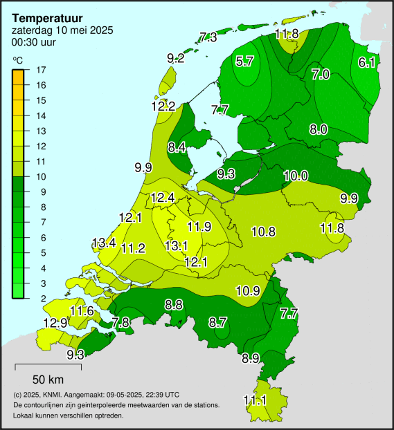
Eerste tropische dag ergens in Nederland van 2016
Hier net boven de 20
Dan zal het hier in Venlo wel een paar graden hoger zijn
<a href="http://www.vwkweb.nl/" rel="nofollow" target="_blank">[b]Vereniging voor weerkunde en klimatologie[/b]</a>
<a href="http://www.estofex.org/" rel="nofollow" target="_blank">[b]ESTOFEX[/b]</a>
<a href="http://www.estofex.org/" rel="nofollow" target="_blank">[b]ESTOFEX[/b]</a>
31,4 in het buitenlandquote:
[..]
Eerste tropische dag ergens in Nederland van 2016
Hier net boven de 20
http://www.buienradar.nl/(...)/maximum-temperatuur
Gaat hard zo.
Je hoort bij de betere, maar nog lang niet bij de beste


Het buitenland...?quote:
[..]
31,4 in het buitenland
http://www.buienradar.nl/(...)/maximum-temperatuur
Gaat hard zo.
Humor....

Staat wel een stukje live beeld van op Facebook, wijkt niet erg af van wat je op de foto zietquote:Op donderdag 23 juni 2016 14:08 schreef Rabieluh het volgende:
[..]
Ik zou de onbewerkte, niet overbelichte, onaangepaste variant ook wel willen zien ja.
Hmz...
Net even buiten in de zon gelegen, na 10 minuten maar weer besloten om naar binnen te gaan, druppels zweet liggen op de grond xd
De atmosfeer staat weer ouderwets op ontploffen. Hier in Nijmegen komt de zon er sinds kort weer goed doorheen met richting Duitsland nog wat chaotische bewolking van de uitstervende buien van de voormiddag. Met een hoge luchtvochtigheid zitten we in een soort 'gaslucht' die alleen nog maar een aansteker nodig heeft.
Laat maar komen dat onweer
Laat maar komen dat onweer
Wat zijn we aan het doen ???
Thx!quote:Op donderdag 23 juni 2016 15:45 schreef Koelkastje het volgende:
Gevonden: https://www.facebook.com/severeweatherEU/videos/1829085433981216/
Wat een lijp ding om te zien
Recht zo die gaat, braaf zo die heen.
Zo'n een ga ik straks ook vastleggenquote:
[..]
Thx!
Wat een lijp ding om te zien.
Hmz...

heb ik vanmorgen gedaan... Alsof ik door een zwembad liep, zo dik en vochtig was de luchtquote:
I can only please one person per day. Today is not your day. Tomorrow isn't looking too good either.
Dat zou iedereen moeten doenquote:
[..]
Zo'n een ga ik straks ook vastleggen
Recht zo die gaat, braaf zo die heen.

Tering, zon komt er idd door. Goed heet nu.
Wens de hardloper hierboven vanavond veel succes. Ik skip even .
.
Wens de hardloper hierboven vanavond veel succes. Ik skip even
Movistar oh Movistar!
Team Movistar Topic
Team Movistar Topic

Dankquote:Op donderdag 23 juni 2016 16:04 schreef RemcoW23 het volgende:
Tering, zon komt er idd door. Goed heet nu.
Wens de hardloper hierboven vanavond veel succes. Ik skip even
“Rather than love, than money, than fame, give me truth.”
De temperatuur gaat ook echt als een raket omhoog hierquote:
 Op
Op Teken van weinig vocht in de lucht
100.000 katjes
Fuck the EBU!
Fuck the EBU!

De wolken lossen wel op zo lijkt het..., het is minder benauwd dan eerder vanmiddag.quote:
[..]
De temperatuur gaat ook echt als een raket omhoog hier
Teken van weinig vocht in de lucht
Find your guiding inspiration. In a place where dreams are made
With a lifetime's preparation. It’s no time to be afraid
Put our differences behind us. While we shine like the sun
See what we've all become. Together we are one
With a lifetime's preparation. It’s no time to be afraid
Put our differences behind us. While we shine like the sun
See what we've all become. Together we are one
Die schijtbuitjes boven Frankrijk moet het niet van komen lijkt me.
Recht zo die gaat, braaf zo die heen.
Dit kan goed een heerlijk zomeravondje worden zonder problemenquote:
Movistar oh Movistar!
Team Movistar Topic
Team Movistar Topic
[quote] Op donderdag 23 juni 2016 16:43 schreef Nattekat het volgende:
Het gaat echt niet ploffen, vergeet dat maar.
[/quote ]
Lijkt er niet op idd, gaat een broeierige nacht worden..
Op donderdag 23 juni 2016 16:43 schreef Nattekat het volgende:Het gaat echt niet ploffen, vergeet dat maar.
[/quote ]
Lijkt er niet op idd, gaat een broeierige nacht worden..
Ik kwam hier net ook een hardloper tegen terwijl de temperatuurmeter van mijn auto op 34,5 stond. (Zal in werkelijkheid wel iets minder zijn geweest). Dan spoor je toch niet.
Overigens nog geen regen of onweer gezien vandaag.
Overigens nog geen regen of onweer gezien vandaag.
http://www.buienradar.nl/nederland/temperatuur/weergrafieken
Blijft nog steeds stijgen die temperatuur.
Blijft nog steeds stijgen die temperatuur.
Recht zo die gaat, braaf zo die heen.
Blijf geloven!!!11
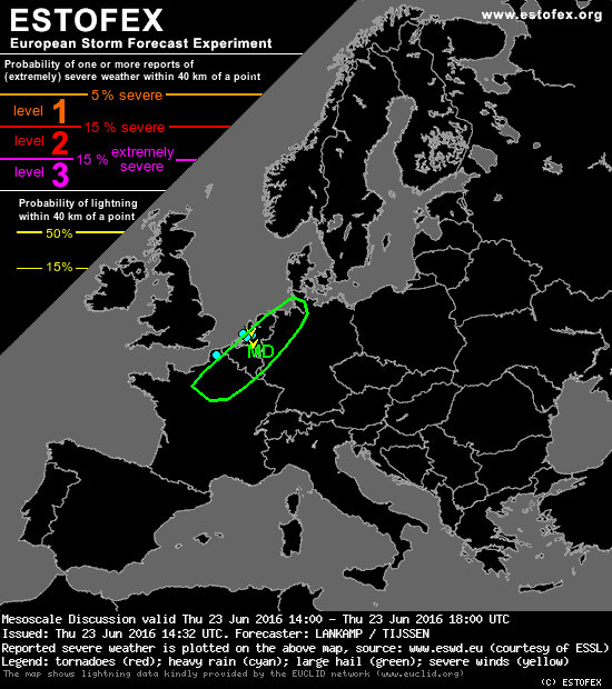
quote:Mesoscale Discussion
Valid: Thu 23 Jun 2016 14:00 to Thu 23 Jun 2016 18:00 UTC
Issued: Thu 23 Jun 2016 14:32
Forecaster: LANKAMP / TIJSSEN
Convective debris is quickly moving away in The Netherlands and Belgium, allowing a couple of hours of strong insolation and surface heating. Surface observations indicate that air mass recovery is fast, with 28 to 30 degrees in large areas and dew points in the lower 20's (20-22)... resulting in mixing ratios of 15-17 g/kg.
The afternoon soundings (12Z) from Trappes and Essen appear largely clear of convective debris. These show slightly less steep mid-level lapse rates than anticipated from DMO output, however, 1500 to 2000 J/kg of CAPE should be available.
As the upper level trough moves eastward, DLS is expected to increase to ~ 23-25 m/s over the eastern parts of Belgium and The Netherlands... and western Germany... in the evening hours. There is a good shear/instability overlap over much of the region and it should provide adequate support for strong and long lived convection.
Satellite images reveal that cumulus convection has started in an area from N France to NW Germany. In the coming hours CI is expected to evolve in this area. Initially, scattered to isolated initiation is expected, as a result of thermal destabilization. At a later stage, storms are expected to cluster as the shear profile gradually becomes more unidirectional.
At time of writing, 1400 Z, surface winds are still backed to the SE or E over eastern NL and Belgium and W/NW Germany, in some places even NE. Using a modified blend of the Trappes/Essen soundings, this results in 100-150 m2/s2 of 0-1 km SRH. Therefore, given the strong instability and presence of more than decent shear, there is a moderate to high risk of large hail (3-5 cm) and damaging wind gusts with any storm that develops. If adequate low-level shear is present, a given storm could easily become a supercell and result in a risk of a (strong) tornado. Excessive convective precipitation is also possible, given the unusually high PW values of the airmass.
Recht zo die gaat, braaf zo die heen.

En de wind begint vanaf zee te komen nu, tijd om kalm af te koelen naar 24 graden zonder explosies.
Recht zo die gaat, braaf zo die heen.
hardlopen dan wel niet maar wandelen doe ik wel met dit weer hoor. Kan het over 3,5 week ook verwachten in Nijmegen. Hoewel we daar vooral smorgens lopen.quote:
Ik kwam hier net ook een hardloper tegen terwijl de temperatuurmeter van mijn auto op 34,5 stond. (Zal in werkelijkheid wel iets minder zijn geweest). Dan spoor je toch niet.
Overigens nog geen regen of onweer gezien vandaag.
Find your guiding inspiration. In a place where dreams are made
With a lifetime's preparation. It’s no time to be afraid
Put our differences behind us. While we shine like the sun
See what we've all become. Together we are one
With a lifetime's preparation. It’s no time to be afraid
Put our differences behind us. While we shine like the sun
See what we've all become. Together we are one

Rotterdam trekt dicht en is een sauna
| Wordfeud: marcel-o |plug.dj/uptempo |<-- draai zelf je platen
Overwegend blauw met wat vriendelijke wolken en 1 bloemkool hier ten oosten van 040. En heet.
*bijvoegelijk naamwoord* koe. Zwartwitgevlekt of roodbont?
die moest ik even quoten.quote:
Overwegend blauw met wat vriendelijke wolken en 1 bloemkool hier ten oosten van 040. En heet.
hier in Wuustwezel plakkend warm maar onweerachtig.
Werewolf
Papa 15/11/1950 - 29/08/2025
Fring is mijn allerliefste knuffelkont
Been haunted by a million screams
Papa 15/11/1950 - 29/08/2025
Fring is mijn allerliefste knuffelkont
Been haunted by a million screams
Die schijtbuitjes boven Frankrijk produceren nu wel opeens bliksem  .
.
Recht zo die gaat, braaf zo die heen.
Het begint hier in Bunschoten dicht te trekken. Had liever wat meer zon gehad, dan hebben we wat meer kans op vuurwerk vanavond.
schitterend, ziet er best photoshopperig uitquote:
Foto Credits: Rick bekker
[ afbeelding ]
[ afbeelding ]
[ afbeelding ]
Dat is zeker wel gedaan...quote:
[..]
schitterend, ziet er best photoshopperig uit
Raar op http://en.blitzortung.org/live_lightning_maps.php?map=16 is er volop bliksem bij Venlo.
Maar ik hoor en zie niks. Dat moet toch wel een hele lokale cell zijn dan
<a href="http://www.vwkweb.nl/" rel="nofollow" target="_blank">[b]Vereniging voor weerkunde en klimatologie[/b]</a>
<a href="http://www.estofex.org/" rel="nofollow" target="_blank">[b]ESTOFEX[/b]</a>
<a href="http://www.estofex.org/" rel="nofollow" target="_blank">[b]ESTOFEX[/b]</a>
Zo dan, heel de ochtend gesukkel, beetje regen, niet veel soeps qua temp.
Nu is het niet te harden meer en heel de middag zon. Dat had ik niet meer verwacht.
Benieuwd of het nog interessant afsluit vandaag...
Nu is het niet te harden meer en heel de middag zon. Dat had ik niet meer verwacht.
Benieuwd of het nog interessant afsluit vandaag...
Forcefield City Bewoner
quote:
[..]
schitterend, ziet er best photoshopperig uit
Gewoon een goed ontwikkeld RAW beeld. Heb stukje terug wel filmpje gepost van dezelfde plek, is wel accuraat weergegeven.quote:
[..]
Dat is zeker wel gedaan...
Raar op http://en.blitzortung.org/live_lightning_maps.php?map=16 is er volop bliksem bij Venlo.
Maar ik hoor en zie niks. Dat moet toch wel een hele lokale cell zijn dan
Hmz...