
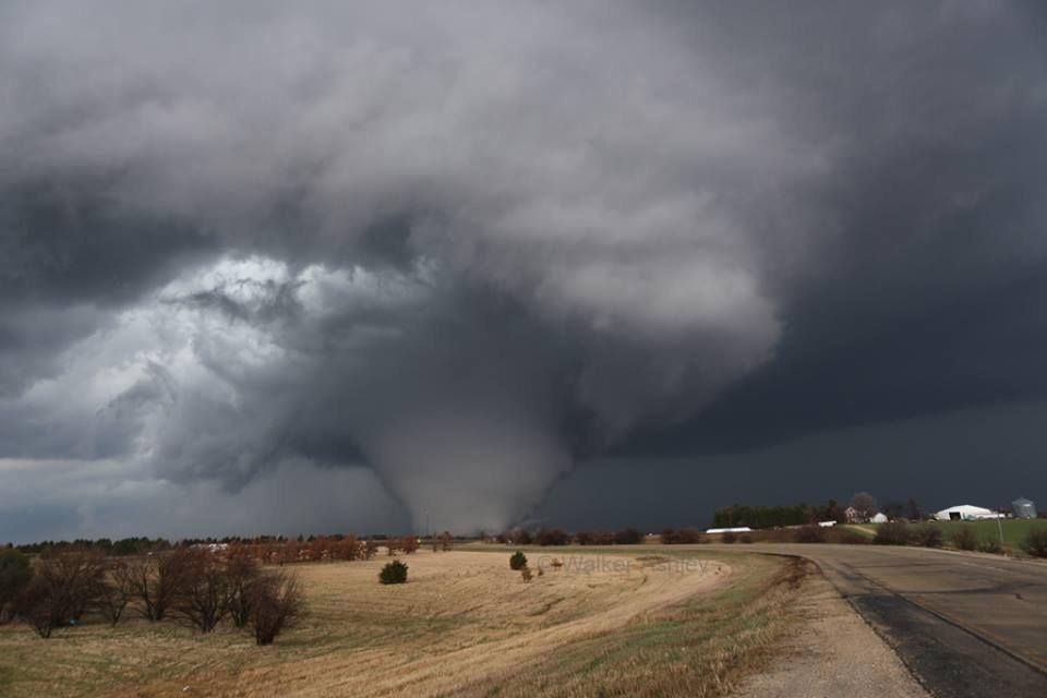
De Verenigde Staten kennen extreme weersituaties. Tornado's en orkanen eisen elk jaar tientallen levens. Plotseling opkomende onweersbuien zijn vooral in Florida gevaarlijk. In bergachtige gebieden en in woestijnen neemt de grond weinig water op en veranderen beekjes als gevolg van hevige regenval plotseling in kolkende watermassa's.
Tornado's
Tornado's ontstaan overal in de Verenigde Staten, maar het merendeel ten oosten van de Rocky Mountains in Texas, Kansas en Oklahoma, ook wel Tornado Alley genoemd. Jaarlijks razen ongeveer 1000 tornado's over de Verenigde Staten.
Er zijn twee tornadoseizoenen. De eerste is in april en mei en het tweede in november. In november beperken de tornado's zich tot Alabama, Mississippi en Louisiana.
Florida is berucht wegens het grote aantal onweersdagen. In Lightning Alley onweert het op meer dan 90 dagen per jaar.
Tornado's vs Orkanen
Tornado's worden vaak verward met Orkanen. Terwijl tornado's lokaal veel schade aan kunnen richten hebben we het bij tornado's over een klein gebied (enkele kilometers in doorsnee) waarbij de zware tornado's windsnelheden van 400-500km/u kunnen halen en daar totale verwoesting aanrichten. Vaak duurt een tornado hooguit enkele minuten of incidenteel tientallen minuten.
zie ook: Tornado information - Wiki en Tornado Fujita Scale
Orkanen daarentegen zijn enorme (onweers-/noodweer) complexen die honderden kilometers qua omtrek kunnen zijn waarbij de zwaarste orkanen windsnelheden van 250-300+ km/u worden gehaald en er een vloedgolf aan water mee komt die meters hoog het land op wordt gestuwd. Tevens kunnen deze complexen wel een dag aanhouden en daarbij enorme hoeveelheden neerslag laten neerdalen op een enorm groot gebied.
Meer informatie over de orkanen vindt je hier:
WKN / Hurricane Season 2014: Orkanen & Cyclonen
Nieuwsberichten, foto's, filmpjes over tornado's, onweer, overstromingen etc etc kun je hier in dit topic kwijt.
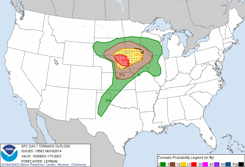
Het Amerikaanse Weather Channel geeft bij elke voorwaarschuwing aan wat de risico's zijn voor die dag en de dagen er na. Dit noemen ze de "TOR:CON" waarde. Aan de hand van die waarde wordt bepaald wat het tornado risico zal zijn:
De TOR:CON index loopt van 0 tot 10. Vermenigvuldig het getal met 10% om het risicopercentage te krijgen dat een tornado binnen 50 mijl het aangegeven gebied zal treffen.quote:8+ Very high probability of a tornado
6 - High probability of a tornado
4 - Moderate chance of a tornado nearby, but hail and/or high wind gusts possible
2 - Low chance of a tornado, but hail and/or high wind gusts possible
0 - Near-zero chance of a tornado or a severe thunderstorm
Enkele site's voor informatie:
• National Weather Service
• Storm Reports
• AccuWeather
• SevereStudios
• National Center for Atmospheric Research
• Stormscape Live
• Current Cape & Lift USA
• Weatheronline Expert maps
• Reddit: Laatste nieuws en updates rondom specifieke oubreaks
Weather Channel Live Zend uit als het echt *nodig* is
• Weather Channel Live
Tv-Stations USA by state
• Newslink TV-stations by state
News channels Alabama:
• CBS42
• Fox Alabama Live
• ABC3340
News channels Arkansas:
• KATV
• Fox16
News channels Kansas:
• KAKE
• KSN
• Kansas Weather Channel
News channels Mississippi
• MS NewsNow
• WCBI
News channels Texas:
• TXCN
• KXXV
• TexasStormChasers
News channels Oklahoma:
• News9
• KFOR
News channel Louisiana/Kentucky
• Wave 3 News
News channel North Carolina
• 9 WNCT
Tornadochasers
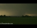
• Tornadovideos.net
• Tornado titans
• Kansas Twisters
• Tornadocentral
• Texas Storm Chasers
• Storm Trackers
El Reno, OK, EF5 tornado 31 mei 2013 - R.I.P. Team Twistex
Moore, OK, EF5 tornado 20 mei 2013SPOILER
Joplin EF5 Tornado 22 mei 2011SPOILER
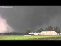
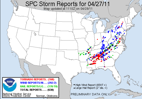
Tornado Outbreak 27 April 2011SPOILER

Tuscaloosa EF4 Tornado 27 April 2011SPOILER
hagelstorm Oklahoma City 16 mei 2010SPOILER

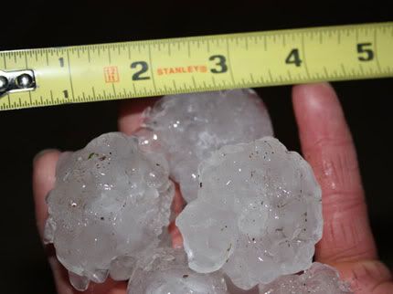
Yazoo City EF4 24 april 2010SPOILERHagelstenen van de onweerstorm
Parkersburg EF5 Tornado 25 mei 2008SPOILER
Greensburg EF5 4 mei 2007SPOILER[quote]Tornado Parkersburg tweede EF5 van de eeuw
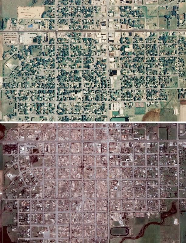
De tornado die zondagmiddag om 18 uur door Parkersburg in de stad Iowa trok is gedefinieerd als een EF-5 tornado. Daarmee is sprake van de tweede EF5-tornado van deze eeuw. De laatste keer dat dit gebeurde was op 4 mei 2007 in Greensburg (Kansas).
De tornado in Parkersburg was de zwaarste tornado voor Iowa sinds 1976. De tornado trok met windsnelheden van 328 kilometer per uur door het dorp en had een breedte van 800 meter. Daarbij vielen volgens de offici�le statistiek van de Nationale Weerdienst 6 doden. 50 mensen raakten gewond.
Bron [/quote]
Vorige delenSPOILER
Topicreeks: Weeralarm VS
[ Bericht 2% gewijzigd door Frutsel op 30-04-2014 12:41:37 ]

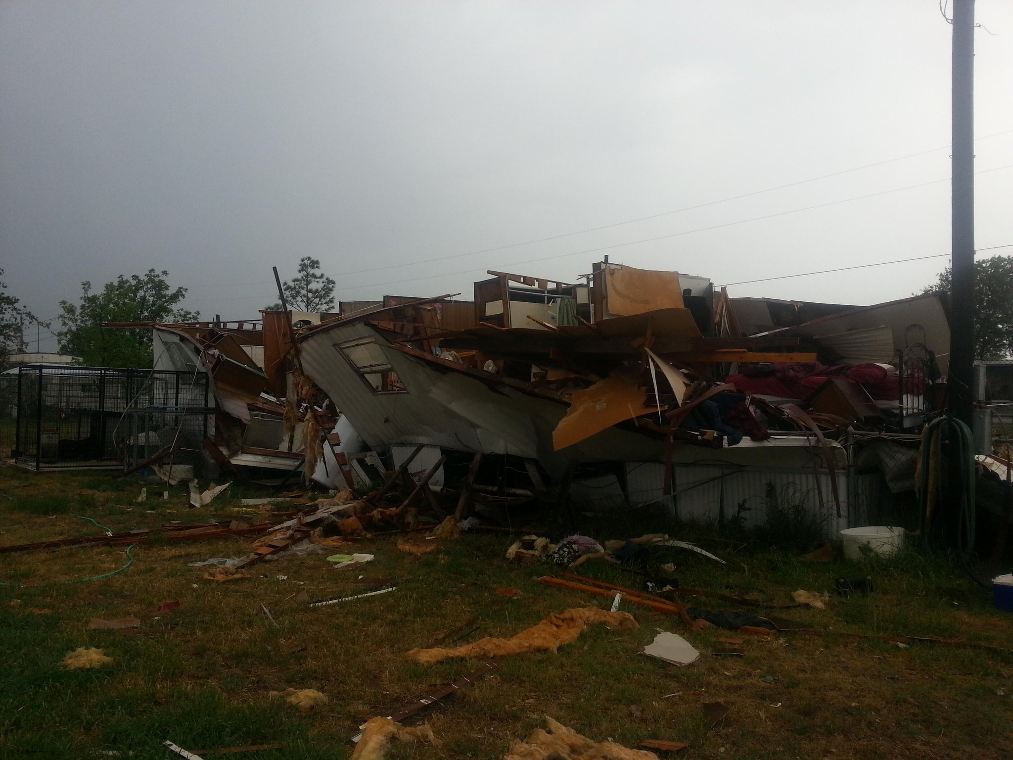
quote:Tornado devastates Tupelo
A tornado caused extensive damage in the north part of Tupelo Monday afternoon.
Residential areas along North Gloster Street, Green Street and the Lakeshire subdivision were hit, and two gas stations were reportedly destroyed.
"Obviously there has been storm damage. It's a very serious situation," Tupelo Mayor Jason Shelton said. "I am just encouraging everyone to stay inside and be weather aware. There is still a very real danger of another line coming through and people still need to be inside."
Shelton said he has heard reports of extensive damage along the busy North Gloster Street thoroughfare that connects downtown to the shopping district but said he hasn't had a chance to survey the damage yet. He has been at Fire Station No. 1 downtown where the county emergency management team has set up its headquarters.
A long-time, popular restaurant — Vanelli's — was destroyed. Vanelli's is a Greek and Italian restaurant that first opened in 1975.
An Outback restaurant reportedly also was destroyed. It is located near the Barnes Crossing in north Tupelo.
Comfort Suites, located just across Gloster from Vanelli's took extensive damage.
twitter:NWSJacksonMS twitterde op maandag 28-04-2014 om 23:24:324:25 PM: MSU storm spotters report Winston County tornado may now be 3/4 mile wide. #mswx reageer retweet


Zie ook het vorige deel
quote:Op maandag 28 april 2014 23:39 schreef INViCTuS het volgende:
Ik denk trouwens dat het later begonnen is en het tot dusver relatief rustig is geweest door de lange en koude winter
Maar kan tot in juni doorgaan... dus we zijn nog maar net echt begonnenquote:The quiet start to the year is no guarantee that the rest of the season will be quiet, especially considering that tornado season typically peaks in May and June. It is a function of the weather pattern that has dominated the lower 48 states since the fall, with a deep dip, or trough, in the jet stream across the Midwest and East, and a ridge of high pressure off the West Coast. The trough brought colder than usual temperatures and above-average snowfall to the East, while the ridge kept the West warmer and drier than average.
http://www.wcbi.com/wordpress/live-wcbi-webcast

Enorm veel regen...


[ Bericht 29% gewijzigd door #ANONIEM op 29-04-2014 03:20:43 ]
http://www.usatoday.com/s(...)west-storms/8353073/
Arkansas - minstens 15
Oklahoma -1
Iowa - 1
Mississippi - 7
Alabama - 2
Ook vandaag weer een nieuwe (moderate risk) kans op zwaar weer in die regionen

quote:


[ Bericht 33% gewijzigd door #ANONIEM op 29-04-2014 10:08:06 ]
Inmiddels 28quote:
Dodental na twee dagen staat op 26
Arkansas - minstens 15
Oklahoma -1
Iowa - 1
Mississippi - 7
Alabama - 2
Ook vandaag weer een nieuwe (moderate risk) kans op zwaar weer in die regionen
2 doden gevonden in Tennessee

twee uur 's nachts?

Daar zag ik echt geen tankstation in...
http://www.breakingnews.c(...)t&utm_medium=twitter
Lekker, midden in de nacht.
twitter:stormchaser4850 twitterde op dinsdag 29-04-2014 om 11:29:17DEVELOPING: ***Significant damage and possible injuries reported after radar-confirmed #tornado near Smiths Station #AL around 4 am CDT *** reageer retweet
quote:Widespread flooding being reported in & around metro Mobile area. Picture via @ALcomMobile


http://www.weather.com/tv/tvshows/live-stream

Lincoln, Tennessee
quote:
9 doden, maar dat gaat waarschijnlijk oplopen.
[ afbeelding ]
http://www.usatoday.com/s(...)west-storms/8353073/
twitter:IrishEagle twitterde op dinsdag 29-04-2014 om 15:58:11Different perspective on the devastation at Parkwood Meadows nbrhd in Vilonia. #ARtornado (Carlo Allegri/Reuters) http://t.co/OXE2fWBbzM reageer retweet

http://mesonet.agron.iast(...)NSJAN&e=201404291720


tornado warning bij Wilson

http://www.weather.com/ne(...)-deep-south-20140427
Bron: weather.comquote:Torrential rain from a pair of thunderstorm clusters triggered major flash flooding along parts of the Alabama Gulf Coast and the Florida Panhandle late Tuesday and early Wednesday. Authorities blamed the flooding for one death in Pensacola, Florida.
Several homes and businesses were flooded, the Pensacola News Journal reported. Resident were stranded in cars and homes waiting for rescuers to find a way around impassable roads and others abandoned vehicles to walk to safety.
A 10-mile stretch of Interstate 10 was flooded and closed from the Alabama state line into western Florida on Wednesday morning. Several roads were also closed throughout Escambia and Santa Rosa counties.
Fire rescue crews weren't able to respond to some calls for help because of road flooding in and around Pensacola, Escambia County spokesman Bill Pearson said.
"We've had people whose homes are flooding and they've had to climb up to the attic," Pearson told The Weather Channel on Wednesday morning.
Pearson said emergency officials had described it was the worst flooding they had seen in 30 years. He cautioned that waters will continues to rise after the rain stops. "If it's a body of water, it poses a safety threat today," he said.
(FORECAST: Pensacola | Mobile)
In Alabama, much of downtown Mobile was flooded and a reverse 911 was sent to residents at Fish River, near Silverhill, where water levels were at their highest for 60 years.
Baldwin County crews had been rescuing stranded people since before midnight and some were in shelters Wednesday morning, emergency management director Mitchell Sims told ai.com the flooding is historic.
"As soon as we get a water rescue team in here, they're sent back out," Sims said. "We're rescuing people from cars, from rooftops, from all over the place.
"I think we're going to be dealing with this for days," added Sims, who estimated that 12 to 17 inches of rain had fallen in 24 hours. "I don't know where the water's going to go. Everything is saturated."
Tuesday was Mobile's fifth-wettest day in 143 years, the National Weather Service said.
The thunderstorms and heavy rain are expected to continue throughout the morning in the region and could linger well into the afternoon, said Jonathan Erdman, weather.com meteorologist
Thx!quote:
Aangezien het volgens mij om hetzelfde weersysteem gaat, plaats ik het toch maar even hier:
[..]
Bron: weather.com
quote:Grote schade door overstromingen Florida
Overstromingen als gevolg van zware regenval hebben in het noordwesten van de Amerikaanse staat Florida zware schade aangericht. Bruggen en wegen zijn weggespoeld en veel huizen zijn ondergelopen.
De snelweg die het oosten en het westen van de staat verbindt, is tussen Fort Walton Beach en Panama City op diverse plaatsen afgesloten, meldt nieuwszender CNN.
De overstromingen hebben een 67-jarige vrouw het leven gekost. Zij reed dinsdagavond (plaatselijke tijd) een sloot in en verdronk. Rick Scott, gouverneur van Florida, heeft de noodtoestand uitgeroepen. Volgens hem zijn driehonderd mensen gered.
"Mensen hebben alles verloren, en ze hadden geen verzekering afgesloten voor overstromingen, omdat ze dachten dat ze niet in een gebied woonden waar overstromingen konden plaatsvinden", aldus Scott.
Alabama
Ook in de aangrenzende staat Alabama is sprake van wateroverlast. Het water steeg daar op sommige plaatsen zo snel dat mensen het dak van hun huis op vluchtten.
Andere delen van de Verenigde Staten werden deze week door tornado's getroffen. Daardoor kwamen zeker 34 mensen om.


Is hier al wat meer over bekend?quote:Op woensdag 30 april 2014 11:11 schreef aloa het volgende:
Volgende week dinsdag/woensdag kan ook weer heftig worden.
[ afbeelding ]

Radar-estimated rainfall for the Florida Panhandle for April 29 and 30, 2014. Precipitation amounts in excess of 12” were indicated just west of Pensacola. The spectacular rains were reminiscent of what happened June 7 - 11 2012. Torrential rains in excess of 20” flooded portions of southern Alabama and the Florida Panhandle when a large plume of moisture from the Gulf of Mexico interacted with an upper-level disturbance over the region. Flooding was particularly severe in Pensacola, FL, where 13.13 inches of rain fell on June 9.
quote:Tornado outbreak death toll rises to 35
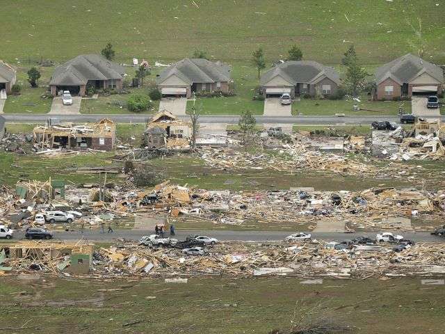
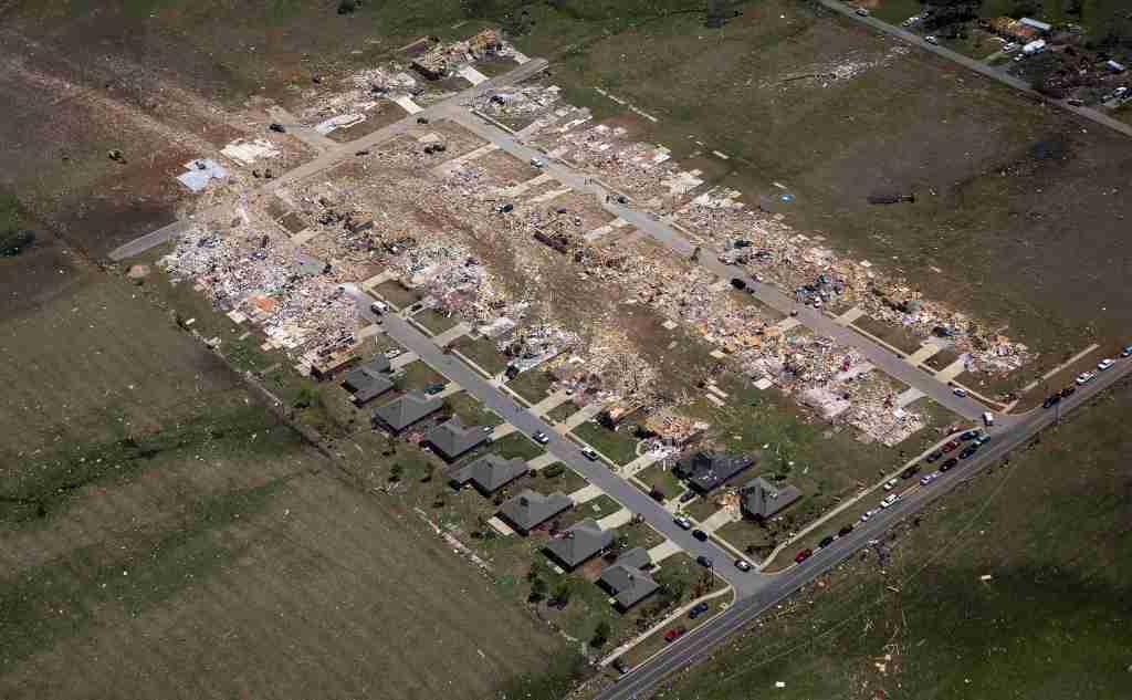
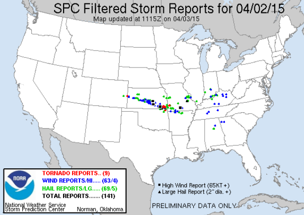
Sunday and Monday’s tornado rampage across the Midwest and Southeast U.S. brought at least five EF-3 tornadoes and one EF-4 tornado, and has claimed 35 lives. For the 24-hour period beginning at 8 am Monday, SPC logged 72 preliminary tornado reports from five states. An additional 35 preliminary tornado reports came on Sunday, bringing the two-day preliminary tornado total to 107. The deadliest tornado was an EF-3 that killed 14 people in Arkansas, ravaging the towns of Mayflower and Vilonia. Damage surveys are not yet complete, but the strongest tornado rated so far was an EF-4 with 185 mph winds that hit Louisville, Mississippi on April 28. The tornado killed nine people, carved a damage path 35 miles long and up to 3/4 mile wide, and stayed on the ground for 56 minutes. The NWS survey noted:
“THIS TORNADO PRODUCED A LARGE AREA OF EF2 TO EF4 DAMAGE ALONG ITS PATH. HUNDREDS OF STRUCTURES WERE HEAVILY DAMAGED AND THOUSANDS OF TREES WERE SNAPPED AND UPROOTED. THE EF4 DAMAGE CONSISTED OF SEVERAL HOMES AND APARTMENTS THAT WERE REDUCED TO SLABS...INDUSTRIAL BUILDINGS THAT WERE COLLAPSED...CHICKEN HOUSES THAT WERE COMPLETELY DESTROYED WITH LITTLE TRACE LEFT OF THEM...DEBARKED AND DENUDED TREES AND A COLLAPSED CELL TOWER.”
Nog wat ver, maar in Oklahoma is er op woensdag/donderdag kans op slecht weer. 20% & 60%.quote:
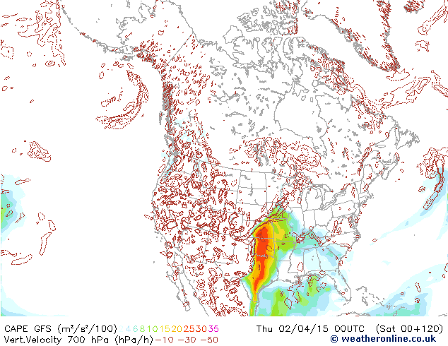
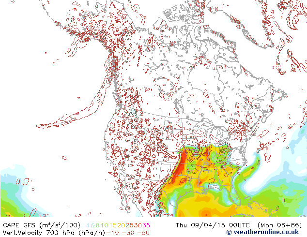
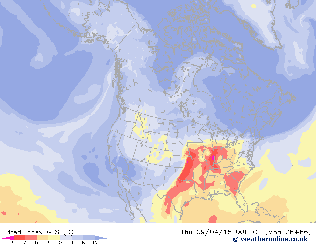
Kans dat het volgende week weer los gaat wordt steeds groter. GFS komt al dagen achter elkaar met zeer hoge cape en lifted kaarten.quote:


(groot plaatje)
SPOILER

quote:"Another batch of storms is likely to erupt from eastern Nebraska and Iowa to parts of Minnesota and Wisconsin Wednesday night into Thursday," Pullin said.
These storms will develop along a warm front, which separates the cool air to the north from warm, moist air to the south.
"The storms along the warm front can bring torrential rainfall, large hail and a few tornadoes," Pullin said.

http://www.accuweather.co(...)reat-plains/26405251


Tornado Danger Peaks Across Plains Again on Thursday
Severe weather will return to the Plains later this week with an outbreak, complete with tornadoes, likely to unfold on Thursday.
Thursday's outbreak will yield numerous thunderstorms capable of unleashing damaging winds, large hail, frequent lightning, flooding downpours and tornadoes.
At this time, the greatest tornado danger on Thursday, mainly during the afternoon and evening, stretches from eastern Nebraska and Iowa to eastern Oklahoma, northeastern Texas and western Arkansas.
Cities in this zone include Dallas and Tyler, Texas, Oklahoma City and Tulsa, Oklahoma, Fayetteville, Arkansas, Topeka and Wichita, Kansas, Kansas City and Springfield, Missouri, Omaha, Nebraska, and Des Moines, Iowa.
http://www.accuweather.co(...)s-across-pl/26499573

Zie ookquote:The deadly and devastating U.S. severe weather outbreak of April 27 - 30, 2014, has finally drawn to a close. The death toll from nature’s 4-day rampage of deadly tornadoes, extreme flooding, and damaging severe thunderstorms has killed at least 39 people, and will end up costing more than $1 billion, according to disaster expert Steve Bowen of Aon Benfield. NOAA’s Storm Prediction Center (SPC) lists 133 preliminary tornadoes over the four days in 14 states; damage surveys are on-going, and 38 of these tornadoes had been confirmed as of noon on May 1.

Vanavond weer een moderate risk, vooral Iowa en Minnesota.
Ik zie het idd.quote:
Aloa je video is verwijderd, mensen die interesse hebben kunnen het filmpje hier nog bekijken: http://www.weather.com/vi(...)ugh-playground-48221
Vanavond weer een moderate risk, vooral Iowa en Minnesota.
[ afbeelding ]
WATCH: Tornado Rips Through Church Playground | T…:

De speeltuin zelf overleeft de stresstest nog verrassend goed.quote:Op donderdag 8 mei 2014 15:07 schreef aloa het volgende:
[..]
Ik zie het idd.
WATCH: Tornado Rips Through Church Playground | T…:
Sterke wind in Dallas Texas. Er liggen ook al wat bomen om en er zijn delen van Dallas zonder stroom:

[ Bericht 41% gewijzigd door PKM op 08-05-2014 22:50:33 ]


Verschillende mensen hebben een live stream aan.
tvnweather.com/live

http://www.severestudios.com/player/jeffrey.gonzales/

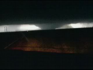
Schade in Pilgrim met 2 tornado's op de achtergrond.

quote:
Schade in Pilgrim met 2 tornado's op de achtergrond.
[ afbeelding ]
Pilger, sorry, heb het steeds verkeerd verstaan.quote:
De stream van Midwest Storm chasers laat nu ook de twee tornado's zien.
Daar hoorde ik ook wat berichten van en dat er veel verwondingen zijn. Het zier er ernstig uit.quote:
Heftig...stadje kon idd wel eens "wiped out" zijn
Bizarre foto zegquote:
15% op z'n meest. Een uur terug ongeveer is er een PDS waarschuwing afgegeven. Het lijkt erop dat het stadje Pilgrim getroffen is door een tornado.
[ afbeelding ]
Schade in Pilgrim met 2 tornado's op de achtergrond.
[ afbeelding ]
Zou haast denken: te echt... must be photoshop


Twitter pic zou zijn vanuit Pilger

Tornado's gezien nabij Wisner (vlakbij Pilger)


[ Bericht 18% gewijzigd door PKM op 17-06-2014 00:13:58 ]

Dit zou een foto uit Pilger, Nebraska zijn..
Schadefoto uit Pilger

[ Bericht 46% gewijzigd door PKM op 17-06-2014 00:54:03 ]


Flyover boven Pilger
Meer foto's:
http://www.weather.com/ne(...)a-tornadoes-20140617
mooie closeup en wat een idioot in die witte auto op het einde.


Significant threat for severe storms including tornadoes today: Iowa Illinois Missouri

Marion, IOWA
quote:Tornado Smithfield may be deadliest in NY state history
The storm that killed four people in Smithfield, New York, on Tuesday evening may have been the deadliest tornado in New York state history.
A survey team from the National Weather Service in Binghamton, New York, determined that a tornado destroyed the homes where four people were killed in this upstate New York town.
The survey crew completed its survey Wednesday afternoon, concluding that the tornado packed winds of up to 125 mph, earning it an EF2 rating on the Enhanced Fujita Scale.
Deadliest Tornado Status Disputed
The status of New York's deadliest tornado is in dispute. According to official data from the National Oceanic and Atmospheric Administration, that dubious distinction belongs to a storm that killed nine children at the East Coldenham Elementary School in Orange County on Nov. 16, 1989.
The children died when a wall fell on them during the storm. While the National Weather Service concluded that the damage was caused by an F1 tornado, the pioneer of modern tornado survey techniques disagreed.
Dr. Theodore Fujita surveyed the damage from that event and concluded that a microburst, rather than a tornado, caused the damage. His findings were later rejected by the Governor of New York, and NOAA continues to list the event as a tornado in its Storm Data catalog.
(MORE: Worst November Tornado Outbreaks)
Even in the immediate aftermath of the 1989 tragedy, there was disagreement over what caused it. A Nov. 17, 1989 article in the New York Times called it a "hurricane-force gust of wind" while noting that several eyewitnesses and the county police believed it to be a tornado.
According to tornado historian Tom Grazulis, the next-deadliest tornadoes on record in New York history each killed three people and each occurred over 100 years ago:
A tornado moved from Onondaga Lake to just north of Syracuse on Sept. 15, 1912, killing three and injuring 40.
A tornado slashed through the town of Willing in Allegany County on Sept. 28, 1884. Three died and 31 were hurt.
Tuesday's tornado will go into NOAA's record books as the second-deadliest tornado in New York history. But in the view of some meteorologists, the Smithfield tornado qualifies the deadliest in state history.
Governor Sees "Pattern of Extreme Weather"
In a press conference Wednesday, Governor Andrew Cuomo lamented the number of disasters during his tenure in office.
"Unfortunately, in my three and a half years as governor, I've seen too many disasters," Cuomo said. "And I've been in settings like this too often."
Citing 11 federally declared disasters in his tenure, Cuomo added, "There is a pattern of extreme weather that is different. We're seeing things that we've never seen. We see floods where homes that have been dry for 100 years get hit with floods and get totally destroyed."
Cuomo said the state had begun citizen preparation training sessions to cope with the spate of natural disasters. "We don't get tornadoes in New York, right? Anyone will tell you that. Well, we do now."
In fact, according to The Weather Channel severe weather expert Dr. Greg Forbes, 418 tornadoes struck the Empire State from 1950 through 2012, ranking New York 30th among all states in total tornadoes, and 36th in tornadoes per square mile.
Is New York Actually Seeing More Tornadoes?
New York's tornado density was 2.10 tornadoes per 10,000 square miles per year from 2000 to 2012, a 71-percent increase from 1.22 in the 1950-1999 period.
However, improved reporting methods have vastly increased the annual number of reported tornadoes in the United States. Many experts believe there is no long-term upward or downward trend in the actual number of tornadoes in the U.S., noting that reports of the most obvious, powerful tornadoes have not shown any upward trend.
For the nation as a whole, the tornado density went from 2.30 in the second half of the last century to 3.66 for 2000-2012, an increase of 59 percent. New York's tornado counts are growing slightly faster than the nation as a whole, but it is unclear whether that is due to increased tornado activity above and beyond the improved reporting system.

http://globalnews.ca/news(...)tured-in-web-series/
Voor de liefhebbers
wauwquote:
Tofquote:
Tornado Hunters - Series starts August 2014
http://globalnews.ca/news(...)tured-in-web-series/
Voor de liefhebbers


Gaaf dat we nu zo'n tornado kunnen ontleden. Daar kunnen die analyses uit Twister niet tegenop.quote:
Genesis and maintenance of a long-track EF5 torna…:

quote:Nicolaus Wegner's Stormscapes 2 video is the most impressive collection of time-lapse severe storm footage I've ever seen. His 7-minute time-lapse compilation of his May - September 2014 adventures in Wyoming, Montana, South Dakota, Nebraska, and Colorado feature an impressive rainbow at 0:40, an incredible orange cumulonimbus at 4:00, a sequence of spectacular funnel clouds and tornadoes beginning at 5:10, and some stunning mammatus clouds at 6:04. Highly recommended.

Wauwquote:
quote:Vier doden bij tornado in Mississippi
Vlak voor Kerstmis zijn in de Amerikaanse staat Mississippi vier mensen bij een tornado om het leven gekomen.
De wervelstorm vernielde volgens zender WDAM delen van de plaats Columbia. Twee mensen overleden toen het natuurgeweld hun wooncaravan trof. Twintig mensen raakten gewond, aldus ABC News.
Huizen raakten beschadigd, auto’s werden in de lucht geslingerd en bomen ontworteld. Duizenden mensen zaten tijdelijk zonder stroom.
In twee districten is de noodtoestand uitgeroepen. Ook in de staten Georgia en Louisiana waren er tornado’s.
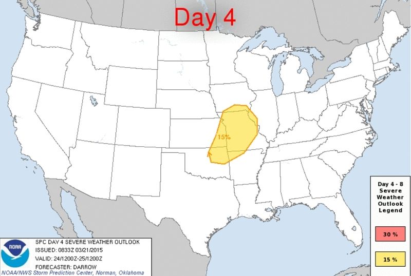
eerste prognoses voor maart zijn er...
http://www.severe-weather(...)a-tornado-potential/
Meldt zich vasttwitter:Frutseltjuh twitterde op woensdag 25-02-2015 om 13:47:391 maart start het #tornado seizoen weer in de VS. Join us en volg het seizoen tot in de late uurtjes via de streams.http://t.co/bELhGViLH6 reageer retweet
Goed bezigquote:Meldt zich vasttwitter:Frutseltjuh twitterde op woensdag 25-02-2015 om 13:47:39
Vandaag een kleine kans op een tornado... voor de komende dagen verder nog niet echt...quote:Severe Weather Forecast: A Few Severe Storms Possible on Thursday`
A rainy weather pattern will be accompanied by some thunderstorms in the South late this week.
Although widespread severe weather is not expected from the disturbances causing the rain, a few storms could turn severe. This potential threat will mainly stay confined to the Gulf Coast states.
On Thursday, the chance for a few severe storms will be from Louisiana and southeast Arkansas to Mississippi, southern/central Alabama, southwest Georgia and the Florida Panhandle. The main threats are localized damaging wind gusts and perhaps a brief tornado. Heavy rain could also trigger local flash flooding.
Below, we have more details on severe weather threats across the country. You can scroll down the page, or click on these links to jump to your area of interest.
quote:25 Years Ago Today: An Early Outbreak for Tornado Alley
The U.S. is in the midst of an extremely quiet March for severe weather thus far, with no tornadoes and only three reports of large hail. Things looked far different 25 years ago today, as the central Great Plains endured its worst late-winter tornado outbreak on record. From March 11 to 13, 1990, more than 60 tornadoes plowed across Tornado Alley, from north Texas to Iowa. The meteorological setup for this outbreak was classic, but the seasonal timing wasn’t. Never before or since have such strong tornadoes been observed so far northwest so early in the year.
Figure 2. Tracks and intensities of the tornadoes observed on March 13-14, 1990, across the central Plains. Image credit: National Weather Service.
The standouts of this outbreak were two long-lived F5 tornadoes that raked central Kansas on the late afternoon of March 13. The twisters were the first in a family of five generated by a single supercell thunderstorm. The first one developed near the town of Pretty Prairie, west of Wichita, and went on to strike the town of Hesston near the end of its 48-mile path, destroying more than 200 homes. As this F5 tornado narrowed and dissipated, a new one formed about a mile to its north within the same larger-scale circulation. An analysis by eminent tornado scientist Theodore “Ted” Fujita found that the two twisters likely rotated around a common axis as the first one dissipated and the second one expanded, delivering a glancing blow to the town of Goessel along its 22-mile path. There have been only four other days since 1950--and none so early in the year--with at least two tornadoes producing F5 or EF5 damage (May 25, 1955; May 15, 1968; April 3, 1974, and April 27, 2011).
Despite the strength and longevity of the Hesston and Goessel tornadoes, they caused only two fatalities. The low death toll becomes even more impressive when you consider the limits of communication and warning technology circa 1990. At that time, the National Weather Service office in Wichita still relied on a 1957-vintage, pre-Doppler weather radar that tracked precipitation but provided no wind data. ”We would draw what we saw on a reflection plotter and then trace contours on a paper map overlay to locate a storm geographically,” recalled Randy Steadham, who was filling in as meteorologist in charge of the Wichita NWS office. The emergence of a classic hook echo on radar, plus a number of eyewitness reports, helped the office to track the storm closely and issue updates roughly every 9 minutes, which made it to the public via radio, TV, and NOAA Weather Radio.

quote:Tornado season is off to a slow start
But March has been known for its deadly and notable severe weather outbreaks in the past.
Not a single tornado has been reported to the National Weather Service so far in March, which typically marks the first month of severe weather season in the Plains and Southeast. According to the Weather Channel’s severe expert Greg Forbes, the only other year since 1950 that there have been zero tornado reports in the first half of March was 1969.
Just seven severe weather reports — two for large hail and five for strong winds — have been reported so far this month. From 1991 to 2010, an average of 80 tornadoes were reported in the month of March across the United States, with the largest number being reported in the South.
January and February were also extremely quiet, weather.com reports:
As of March 12, only 27 tornadoes had been documented across the nation, according to statistics from The Weather Channel severe weather expert Dr. Greg Forbes. This is the slowest start to the year, tornado-wise, since the 21 tornadoes recorded through March 12, 2003.
February was eerily quiet, with only two tornadoes reported during the month; one in California, the other in Florida. According to statistics kept by Dr. Forbes, only three other Februaries since 1950 saw two or fewer tornadoes in the U.S.: 2010 (1), 2002 (2) and 1964 (2).
Greg Carbin, warning coordination meteorologist at the Storm Prediction Center (SPC) noted only four tornado watches were issued by the SPC in January and February combined, the fewest in the year’s first two months since 1985 required only two tornado watches.

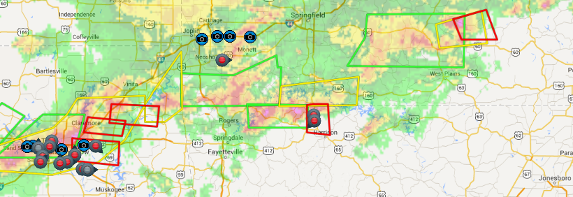
twitter:weatherchannel twitterde op dinsdag 24-03-2015 om 23:48:253D radar shows big #Hail building in these 2 storms just SW of #Springfield MO #mowx #severe http://t.co/hvTucqlTia reageer retweet

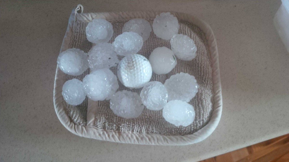
twitter:TWCBreaking twitterde op woensdag 25-03-2015 om 00:55:59Tornado Warning for Boone and Marion Counties in AR until 7:30 PM CDT http://t.co/ruJjPGx9Ua reageer retweet

[ Bericht 5% gewijzigd door Houtenbeen op 25-03-2015 01:03:26 ]
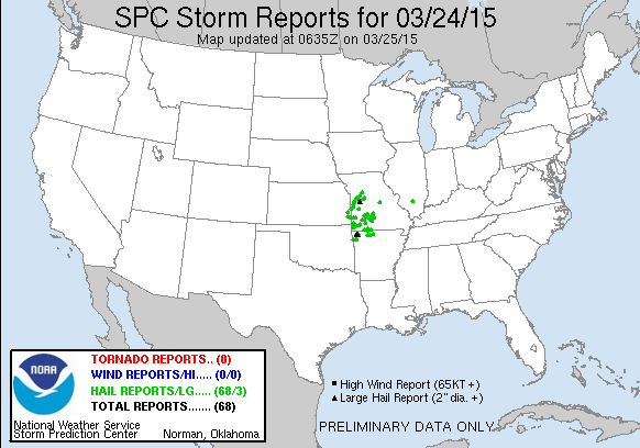
volgens de storm reports wel.quote:
Eind maart misschien nog een kans in het zuiden van de VS.
Bronquote:Another disturbance will move into the Plains on Wednesday bringing the risk for large hail, damaging winds and isolated tornadoes.
The first severe thunderstorm watch of 2015 was issued over parts of four states as the first threat of organized springtime severe weather targeted the nation's midsection on Tuesday. There were more than 60 reports of hail between 1 and 2 inches in diameter on Tuesday night.
In what has been a very quiet year for severe weather, NOAA's Storm Prediction Center had issued only four watches this year before Tuesday's watch. All of those were tornado watches – three in January and one in February.
Wednesday: Scattered severe thunderstorms should again break out by mid-late afternoon, this time near the intersection of a bulge in a surface dryline and cold front in Oklahoma, north Texas and southeast Kansas. During the evening, this activity is expected to form a squall line and push across central and southern Missouri and at least northern Arkansas. Damaging winds and large hail will again be the primary threats, but a tornado cannot be ruled out.
Kan nog steeds vandaag

twitter:weatherchannel twitterde op woensdag 25-03-2015 om 12:46:55
Kan nog steeds idd. Kans op tornado's is klein, maar volgens mij groter dan gisteren.quote:


moderate risk idd. Kan laat worden vanavond.quote:
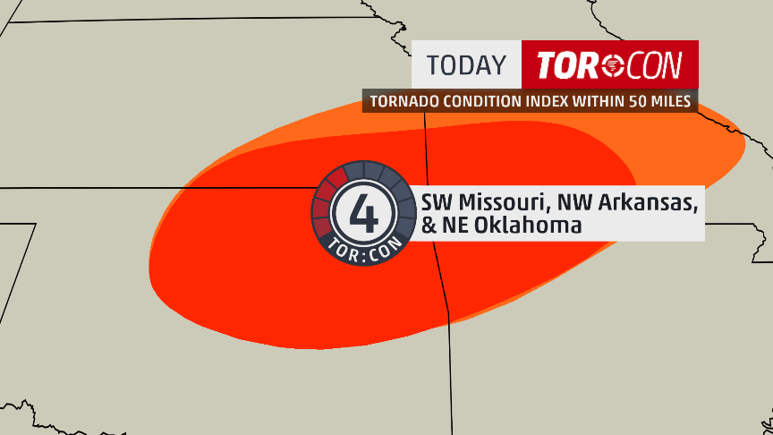
Nieuwe update: Kans wordt ineens een stuk groter
[ afbeelding ]
Tis voornamelijk voor grote hagel, maar een isolated tornado event is mogelijkquote:Op woensdag 25 maart 2015 15:01 schreef aloa het volgende:
[..]
moderate risk idd. Kan laat worden vanavond.
twitter:NWStulsa twitterde op woensdag 25-03-2015 om 17:11:29We have upped our SVR and TOR probs based on latest data. Expect storms to develop in NE OK 3-4 PM. #okwx #arwx http://t.co/zfLjV4uR4k reageer retweet
[ Bericht 20% gewijzigd door #ANONIEM op 25-03-2015 18:49:15 ]
Schitterende buien momenteel.quote:
zit al een chaser bij joplin te streamen
twitter:TWCBreaking twitterde op woensdag 25-03-2015 om 22:51:17
twitter:TWCBreaking twitterde op woensdag 25-03-2015 om 23:13:45

twitter:weatherchannel twitterde op woensdag 25-03-2015 om 23:26:39


[ Bericht 100% gewijzigd door Houtenbeen op 25-03-2015 23:36:18 ]
Schitterend.quote:
Veel chasers bij Tulsa.
tornado zat achter hemquote:


[ Bericht 2% gewijzigd door Houtenbeen op 25-03-2015 23:44:56 ]
Tornado in Moore
Dat stadje word wel erg vaak belaagd door tornado's, vorg jaar ook al.quote:
http://kfor.com/on-air/live-streaming/
Tornado in Moore
twitter:abcnewswx twitterde op donderdag 26-03-2015 om 02:04:17JUST IN: Tulsa Co. Sheriff's Office: 1 dead, others injured after tornado-warned storm moves through Sand Springs, Oklahoma. reageer retweet

Foto van de tornado in post 141
[ Bericht 5% gewijzigd door Houtenbeen op 26-03-2015 02:43:37 ]
twitter:weatherchannel twitterde op donderdag 26-03-2015 om 03:06:56


Moore #tornado seen from my hotel room in Norman
https://www.facebook.com/video.php?v=790527554349697
Wat een groot ding zegquote:
Prachtige video van de tornado gisteren bij Moore. En gek om te zien hoeveel auto's er nog op die weg reden.
https://www.facebook.com/video.php?v=790527554349697
fok zegquote:
Prachtige video van de tornado gisteren bij Moore. En gek om te zien hoeveel auto's er nog op die weg reden.
https://www.facebook.com/video.php?v=790527554349697
al die "power flashes"
Is de kracht al bekend?
F1-F2 dachten ze gisteren avond op die newstreamquote:
[..]
fok zeg
al die "power flashes"
Is de kracht al bekend?

twitter:weatherchannel twitterde op dinsdag 31-03-2015 om 21:51:31a large #hail core... analysis continues on @weatherchannel http://t.co/Zd4KwrxUVt reageer retweet

1chaser maar
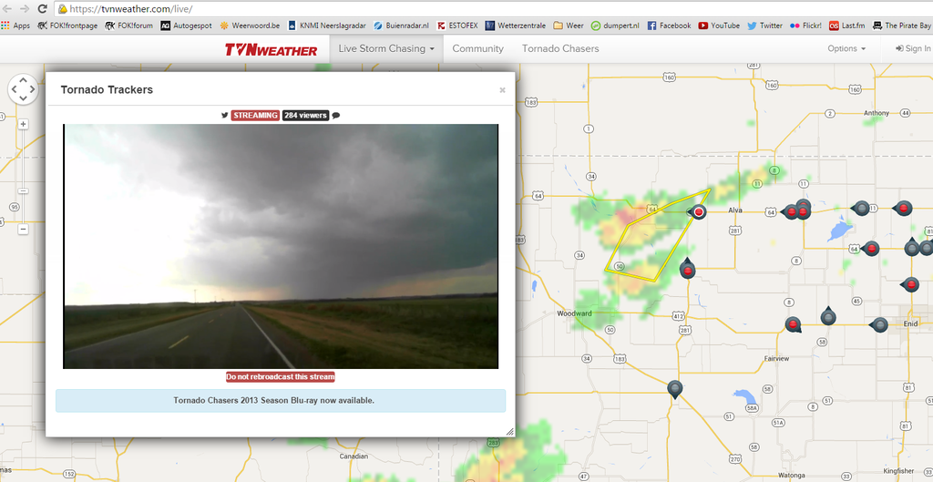
https://tvnweather.com/live/
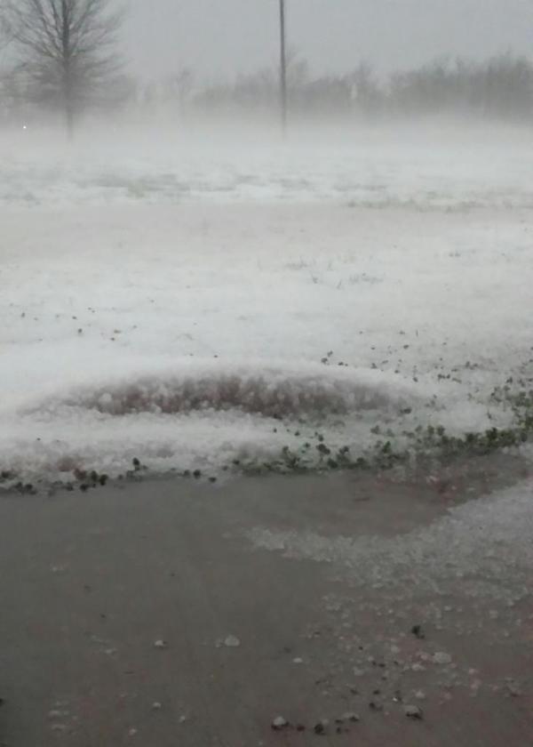
twitter:breakingweather twitterde op dinsdag 31-03-2015 om 22:11:05Baseball-sized hail reported 3 mi S of Gillett, AR, according to NWS spotter. Radar: http://t.co/0Ll4PyjbAv reageer retweet

[ Bericht 5% gewijzigd door Houtenbeen op 01-04-2015 16:12:50 ]

Morgen

Vrijdag

Zaterdag

Komende dagen verhoogde kansen al zit er nog geen moderate risk bij.
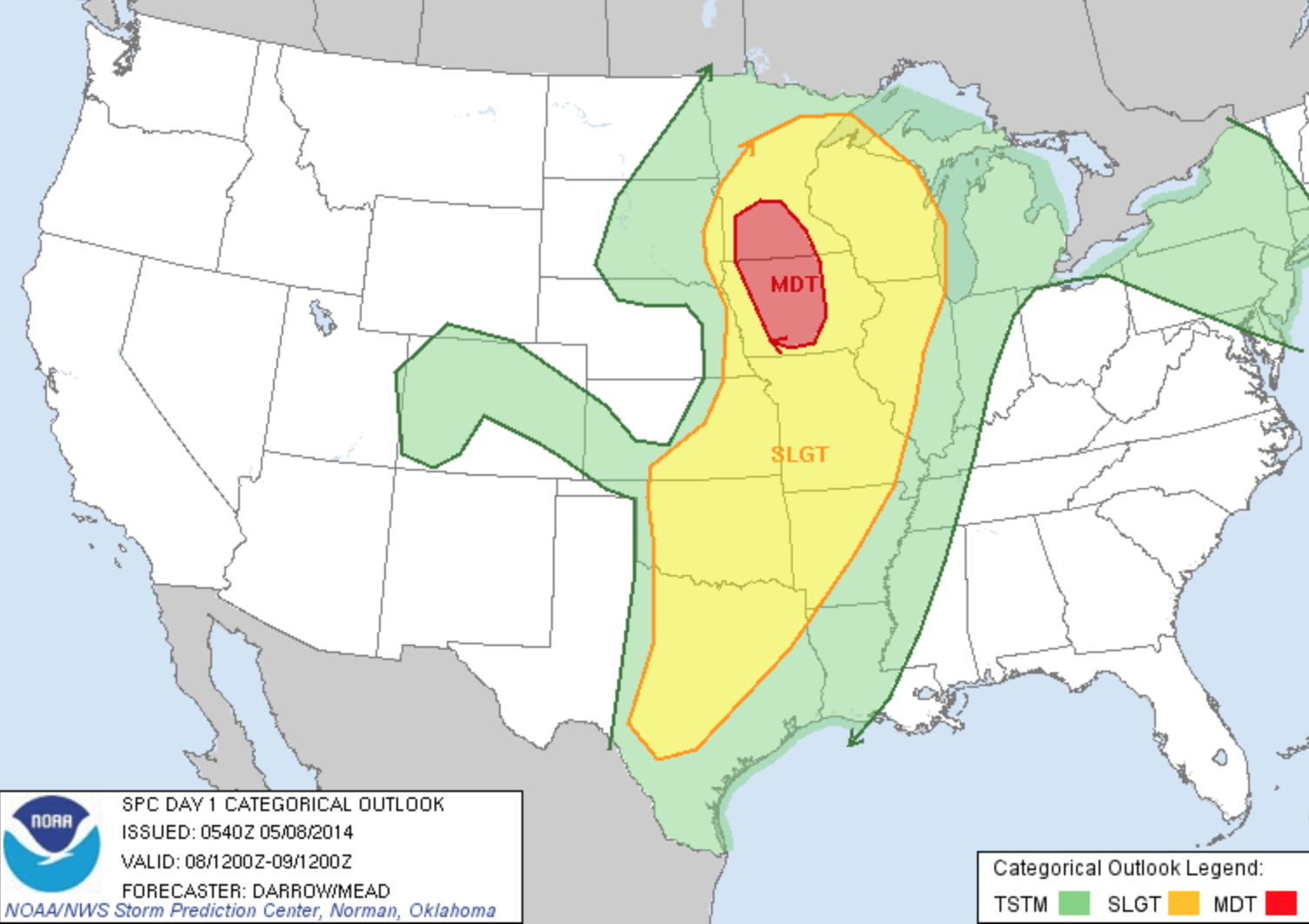
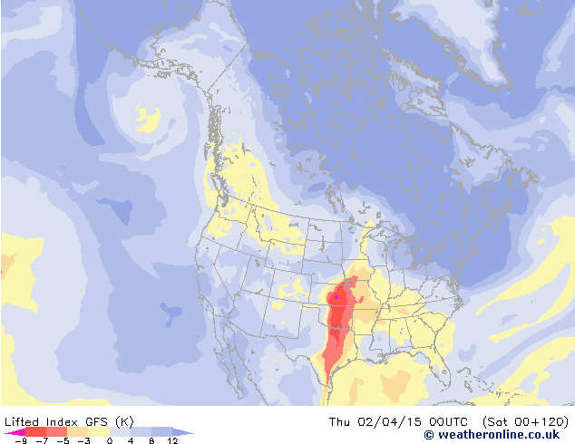
quote:Severe Storms Looming for Early April
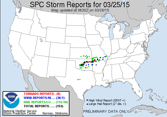
The first ten days of April could produce more severe weather than the modest amount racked up so far across the U.S. in 2015. The same upper-level pattern that kept the West warm and the East cold through most of the winter has also kept severe weather to a minimum, as northwest flow and a series of cold fronts pushed warm, unstable air off the U.S. mainland. This year through March 30, we’ve seen a preliminary total of a mere 38 tornadoes, compared to a January-March average over the preceding three years of 163. As of Tuesday morning, NOAA’s Storm Prediction Center had issued just four tornado watches and four severe thunderstorm watches for the year thus far. This compares to a long-term Jan.-Mar. average (1970 – 2014) of around 39 tornado and 24 severe thunderstorm watches, according to SPC’s Greg Carbin.
The 2015 numbers look destined to rise over the next few days, as a major circulation change takes place over North America. The long-prevailing northwest flow is being replaced this week by more zonal (west-to-east) flow, with an embedded upper-level impulse reaching the Midwest on Wednesday and another targeting the Southern Plains on Thursday. A moist low-level air mass is already in place, with dew points close to 60�F from Tulsa, OK, to Birmingham, AL. Surface low pressure generated by the upper-level impulses should continue to pull the moisture pool northward and generate unstable conditions. SPC placed a broad belt from Oklahoma to Georgia under a slight risk of severe weather for Tuesday afternoon and evening, with large hail possible as the moisture continue to flow north.
A large swath of the Great Plains is under an slight risk for Wednesday, from northwest Oklahoma to southern Minnesota, with an slight risk in place for Thursday across part of the Southern Plains and mid-Mississippi Valley. The predominantly west-to-east upper flow combined with southerly low-level flow will enhance vertical wind shear, a key ingredient in the formation of supercell thunderstorms. The main threats appear to be high winds and large hail, although tornadoes can’t be ruled out. As was the case last Wednesday, when F2 tornadoes struck the Tulsa suburb of Sand Springs and the Oklahoma City suburb of Moore, the corridor from Interstate 44 into east central Oklahoma could be a particular focal point for supercell formation by late Thursday. Severe weather may continue into the lower Mississippi Valley on Friday before the associated cold front moves into the Gulf of Mexico.
Forecast models indicate a strong upper-level trough will settle across the Great Basin by early next week, setting the stage for what could be a more extensive multiday round of severe weather beginning as soon as Sunday. A strong surface low should develop over the High Plains by late in the weekend, pulling unstable air back northward across a large area beneath west-southwest upper flow. Strong thunderstorms could spread across the Midwest and South by early next week, with several days of focused severe weather possible.
twitter:weatherchannel twitterde op woensdag 01-04-2015 om 14:41:55

twitter:JenCarfagno twitterde op donderdag 02-04-2015 om 15:22:02Tornado threat today, tonight & tomorrow. @twcMariaLaRosa @GregPostel & I on @weatherchannel from 10a-2p edt. http://t.co/pOhCZwgjz7 reageer retweet
[ Bericht 44% gewijzigd door Houtenbeen op 02-04-2015 16:51:53 ]
twitter:TWCBreaking twitterde op donderdag 02-04-2015 om 22:51:53

[ Bericht 5% gewijzigd door Houtenbeen op 02-04-2015 23:08:54 ]

http://www.ky3.com/weather/cameras/lebanon-camera/25901376
Tornadowaarschuwing is ingetrokkenquote:
De onweersbui van Missouri in beeld, er zijn vooralsnog geen/weinig chasers in de buurt.
[ afbeelding ]
http://www.ky3.com/weather/cameras/lebanon-camera/25901376
Maar waarschijnlijk weer snel een nieuwe
twitter:NWSSPC twitterde op donderdag 02-04-2015 om 23:49:364:49pm CDT #SPC_MD 0189 concerning severe potential...tornado watch likely, http://t.co/qOWHqqQIQy http://t.co/1KBMFavl6c reageer retweet

[ Bericht 45% gewijzigd door Houtenbeen op 02-04-2015 23:54:16 ]
twitter:TWCBreaking twitterde op vrijdag 03-04-2015 om 01:52:37
twitter:weatherchannel twitterde op vrijdag 03-04-2015 om 02:05:39

twitter:weatherchannel twitterde op vrijdag 03-04-2015 om 02:11:51
twitter:breakingweather twitterde op vrijdag 03-04-2015 om 02:13:21

twitter:TWCBreaking twitterde op vrijdag 03-04-2015 om 02:16:22
twitter:TWCBreaking twitterde op vrijdag 03-04-2015 om 02:16:24
[ Bericht 27% gewijzigd door Houtenbeen op 03-04-2015 02:19:07 ]
twitter:weatherchannel twitterde op vrijdag 03-04-2015 om 02:46:50

[ Bericht 16% gewijzigd door Houtenbeen op 03-04-2015 02:54:18 ]
twitter:weatherchannel twitterde op vrijdag 03-04-2015 om 03:10:25

twitter:weatherchannel twitterde op vrijdag 03-04-2015 om 03:14:07

twitter:weatherchannel twitterde op vrijdag 03-04-2015 om 03:44:43

Brief tornado in Labetta County, Kansas

twitter:weatherchannel twitterde op vrijdag 03-04-2015 om 15:38:52

twitter:NWSSPC twitterde op vrijdag 03-04-2015 om 18:58:08


twitter:NWSSPC twitterde op vrijdag 03-04-2015 om 19:20:07
[ Bericht 29% gewijzigd door Houtenbeen op 03-04-2015 19:23:47 ]
twitter:weatherchannel twitterde op zaterdag 04-04-2015 om 00:02:52

twitter:weatherchannel twitterde op zaterdag 04-04-2015 om 02:52:39


Alleen geen chasers daar
outbreak coming up?
Eens zien wat het gaat worden...quote:
https://twitter.com/AviWxChasers/status/584357076471713794
outbreak coming up?
quote:
https://twitter.com/AviWxChasers/status/584357076471713794
outbreak coming up?
twitter:breakingweather twitterde op maandag 06-04-2015 om 00:30:38

twitter:weatherchannel twitterde op dinsdag 07-04-2015 om 18:55:01


http://www.accuweather.co(...)r-outbrea-1/45123731
twitter:TWCBreaking twitterde op dinsdag 07-04-2015 om 21:50:23
twitter:weatherchannel twitterde op dinsdag 07-04-2015 om 21:54:37

https://tvnweather.com/live
twitter:weatherchannel twitterde op woensdag 08-04-2015 om 00:25:53

[ Bericht 4% gewijzigd door Houtenbeen op 08-04-2015 00:49:57 ]
twitter:weatherchannel twitterde op woensdag 08-04-2015 om 02:15:00


quote:SRN AND CNTRL PLAINS THROUGH THE LOWER MO VALLEY...
PARTIALLY MODIFIED GULF AIR IS IN PLACE OVER THE SRN PLAINS...AND
LOW-LEVEL LOW TO MID 60S F DEWPOINTS SHOULD CHARACTERIZE MUCH OF THE
WARM SECTOR DURING THE AFTERNOON. THE 00Z WED RAOBS INDICATE AN EML
WITH STEEP LAPSE RATES HAS ALREADY ADVECTED ABOVE MUCH OF THIS
REGION...AND DIABATIC WARMING OF THE BOUNDARY LAYER SHOULD BOOST
MLCAPE TO 2500-3500 J/KG WEDNESDAY AFTERNOON. ELEVATED STORMS MAY
DEVELOP EARLY IN THE PERIOD NORTH OF THE STALLED FRONT FROM ERN KS
INTO MO...AND SOME OF THIS ACTIVITY MAY POSE A THREAT FOR LARGE
HAIL. CURRENT INDICATIONS ARE THAT MOST OF THE WARM SECTOR WILL
REMAIN CAPPED MUCH OF THE DAY. SOME MODEL SOLUTIONS INITIATE STORMS
BY EARLY AFTERNOON FROM NRN TX INTO OK...BUT THIS ACTIVITY MIGHT BE
MID-LEVEL CONVECTION ROOTED ABOVE THE CAP AND DEVELOPING IN RESPONSE
TO THE SRN-STREAM JET STREAK.
CURRENT THINKING IS THAT SFC-BASED STORMS WILL INITIATE ALONG THE
DRYLINE-FRONT INTERSECTION OVER NCNTRL OK OR SCNTRL KS BY LATE
AFTERNOON...WHILE OTHER MORE ISOLATED ACTIVITY MAY DEVELOP FARTHER
SW FROM THE ERN TX PANHANDLE INTO WRN TX WITHIN ZONE OF DEEP MIXING
ALONG THE DRYLINE. DEEP-LAYER SHEAR PROFILES WILL STRENGTHEN TO
40-50 KT WITH APPROACH OF THE MID-LEVEL JET STREAK SUPPORTIVE OF
SUPERCELLS CAPABLE OF PRODUCING VERY LARGE HAIL. THREAT FOR
TORNADOES /A COUPLE OF WHICH COULD BE STRONG/ WILL ALSO INCREASE BY
LATE AFTERNOON INTO THE EARLY EVENING AS THE LLJ STRENGTHENS IN
ASSOCIATION WITH DEEPENING LEE LOW. ACTIVITY IS EXPECTED TO DEVELOP
NEWD THROUGH THE MID MS VALLEY AREA DURING THE EVENING WITH A
CONTINUED THREAT FOR LARGE HAIL...DAMAGING WIND AND A FEW TORNADOES.
GIVEN THE POTENTIAL FOR SIGNIFICANT SEVERE...AN UPGRADE TO MODERATE
RISK MIGHT BE NEEDED IN LATER UPDATES ONCE MORE
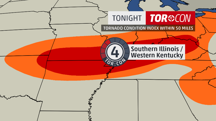
twitter:jjabraham twitterde op woensdag 08-04-2015 om 18:05:24Hey #MidMO: @DrGregForbes just raised the TOR:CON to a 6 in central MO. 60% chance of a tornado within 50 miles. Stay safe today! #CoMO reageer retweet
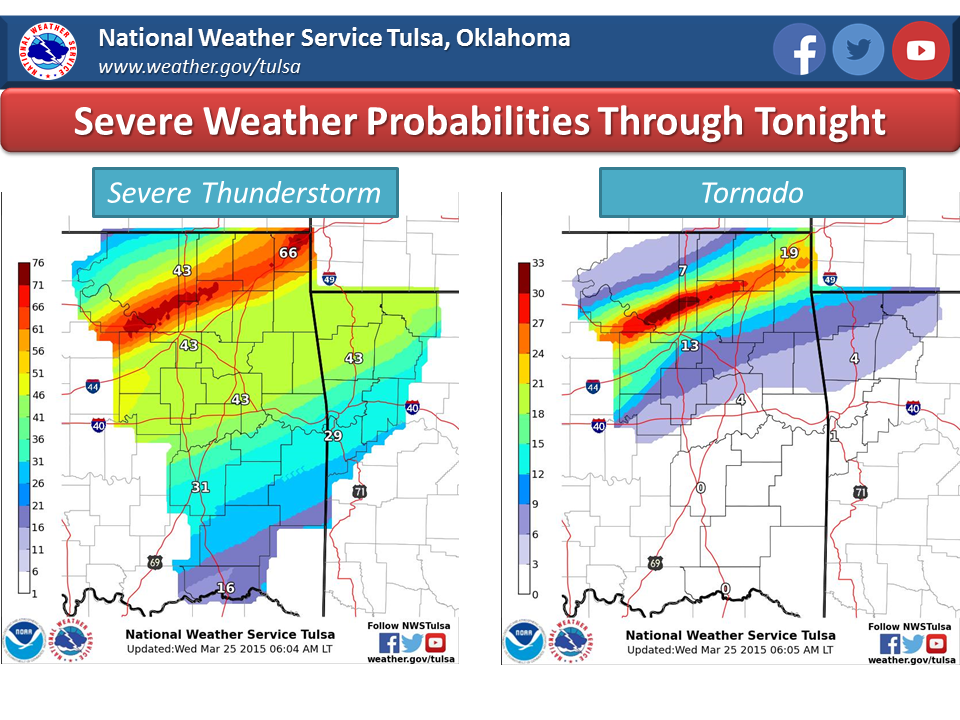
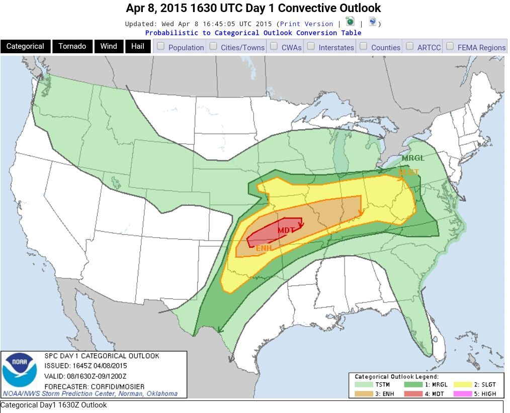
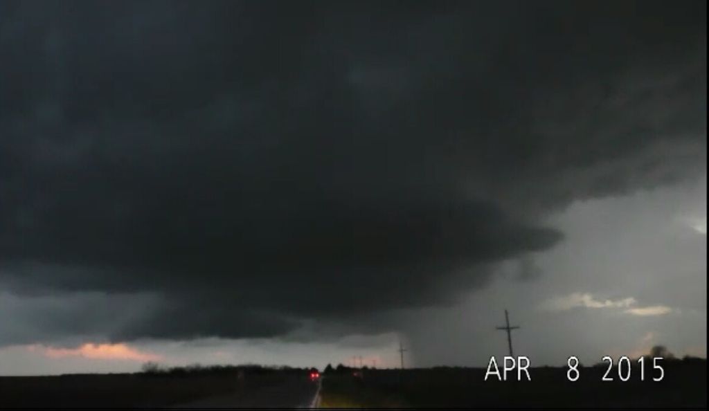
quote:Wednesday, April 8, 2015
Scattered severe thunderstorms in WV, central and south OH, central and south IN, central and south IL, north KY, MO, east and south-central KS, OK, except for panhandle, northwest TX near Childress, Abilene, and Wichita Falls, northwest AR. TOR:CON - 6 central and south MO; 5 southeast KS, north-central OK; 4 southwest OK; 3 rest of area above.
Wednesday Night, April 8, 2015
Severe thunderstorms in central and south IN, central and south IL, west KY, north and west AR, MO, south IA, east and south-central KS, OK except for panhandle, central TX. TOR:CON - 6 central and southwest MO and southeast KS; 5 central and northeast OK; 4 central TX; 3 rest of area.
twitter:TWCBreaking twitterde op woensdag 08-04-2015 om 22:11:09
twitter:TWCBreaking twitterde op woensdag 08-04-2015 om 22:20:32
[ Bericht 33% gewijzigd door Houtenbeen op 08-04-2015 22:21:15 ]

Lekker hagelstenen daar in Kentucky jaquote:
Au!
Veel rotatie in die celquote:
*edit: aha https://tvnweather.com/live/
en
http://www.chasertv.com/
Waarschijnlijk een tornado op de grond? Lijkt wel zo op de radar:
Leuk ja, de motorkap omhoog en allesquote:
Via hier, https://www.youtube.com/channel/UCWAN-rRJFLosqgiiIFVpkEQ , is oa Brandon Ivey te volgen. Jammer genoeg problemen met zijn auto. Op de andere stream zijn ze rustig aan het afwachten met een aantal chasers (Tony Laubach, Skip Talbot)
Waarschijnlijk een tornado op de grond? Lijkt wel zo op de radar:
[ afbeelding ]
De chasers worden langzamerhand al wat zenuwachtiger.
http://nowwatchtvlive.me/(...)ing-weather-network/
Ten zuiden van Washington (Indiana) net ook flinke rotatie.
Dit lijkt wel de juiste stream te zijn, ik kijk hem namelijk ookquote:
Reclame... En daarvoor was 't ook niet veel. Of is dit niet de juiste stream?
http://nowwatchtvlive.me/(...)ing-weather-network/
Alleen de kwaliteit is iets minder dan de verdwenen officiele stream. Ze hebben niks te melden
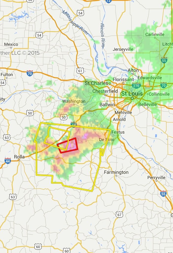
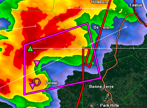
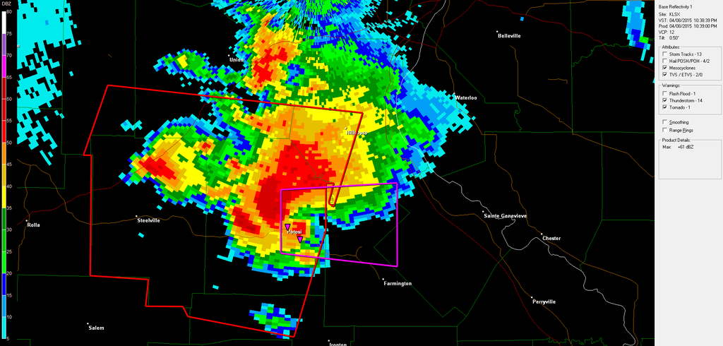
twitter:28storms twitterde op woensdag 08-04-2015 om 23:12:44Potosi [Washington Co, MO] roofs blown off buildings. Hoods blown off vehicles at the modot facility just east of Potosi.#MOwx reageer retweet
Edit:
3,25 inch hagelstenen in die bui nu
[ Bericht 10% gewijzigd door Houtenbeen op 08-04-2015 23:37:45 ]
Werkt nog best goed op mobiel. Helaas moet ik gaan slapen.quote:
Nu mooi beeld op https://tvnweather.com/live/ .
[ afbeelding ]
twitter:severestudios twitterde op donderdag 09-04-2015 om 00:40:41RT @severeweatherEU: aerial view over explosive severe storms near Elk City, Oklahoma! By Barry King http://t.co/GomAQXhJhM reageer retweet

Brandon Clement is in een Tornado Warning area in Oklahoma

Was goed in beeld jaquote:
De stream van Ben McMillan heeft een tornado.
Meer zie ook hier:quote:Here's the latest news from this round of severe weather:
A 75-year-old Hendricks County, Indiana, woman was killed after falling into a stream. She was clearing debris from a flooded ditch.
Five people were injured after a Tulsa school bus rolled off Highway 75 in Oklahoma. Weather and speeding appear to be factors.
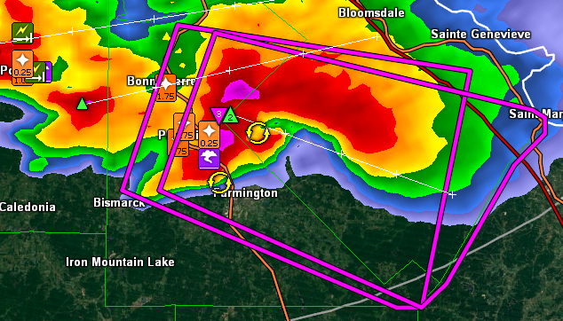
A severe thunderstorm caused significant damage in Potosi, Missouri, between 3:30 and 4 p.m. CDT Wednesday afternoon. Some buildings lost roofs in the storm. There was a report of a possible tornado in the area, but there were no photos of the purported tornado.
Grapefruit-sized hail was reported around Sullivan, Missouri, around 2:30 p.m. CDT. There are reports of smashed car windshields and damage to homes. Hail up to the size of softballs struck Farmington, Missouri, around 4:45 p.m.
A tornado touched down in Comanche County, Kansas. Minutes later, the same storm spawned another tornado, which lasted 3 to 5 minutes, in rural Barber County, Kansas.
A University of Dayton student is in serious condition after being struck by lightning on campus.
http://www.weather.com/st(...)orm-outbreak-impacts

Twitter: Viewer photo of golf ball-size hail this morning in #MidMO, near Columbia. #MOwx

Twitter: Franklin Co. Sheriff Gary Toelke sent in this hail photo of damage to Franklin Co. patrol car. #mowx #stlwx
Veel meer foto's hier -->
http://www.weather.com/st(...)weather-april-photos

Torcon is net verhoogd naar 6 voor Iowa, Indiana en Illionoisquote:
twitter:THESarahD29 twitterde op donderdag 09-04-2015 om 17:40:54JUST IN: @DrGregForbes has just increased the #TorCon to a 6 for eastern #Iowa, #Illinois, and western #Indiana. Stay with @weatherchannel! reageer retweet
Funnel in die celquote:

Duidelijke hook.
De lijn in Missouri begint er ook steeds meer gestructureerd uit te zien. Zitten een paar leuke cellen op.
https://tvnweather.com/live
Paul Goddard


Rochelle, IL
Damn... slachtoffers?quote:

TORNADO this Thursday evening seen near Rochelle, Illinois.


wat een monster
quote:Zeker ��n dode door tornado in Illinois
De tornado die donderdagavond door Illinois raasde heeft minstens ��n vrouw het leven gekost. Meerdere mensen zijn gewond geraakt en verschillende gebouwen werden vernietigd.
Een 67-jarige vrouw uit Fairdale werd dood teruggevonden in haar huis. Door een inslag op een restaurant hebben een tiental mensen vastgezeten in de kelder maar reddingswerkers hebben die intussen kunnen bevrijden. De tornado is ��n van meerdere die over het gebied trokken. Volgens het weerstation zou er meer slecht weer op komst zijn.
http://www.weather.com/st(...)na-ohio-april-9-2015
Apparatuur die niet te betalen is voor jan met de pet denk ik?quote:
Hoe streamen ze zo massaal die beelden joh? Ze zitten in de middle of nowhere. En dan te bedenken dat dit alleen maar beter wordt, dadelijk allemaal live HD beelden van tornado's
goeie genadequote:

Enhanced Risk donderdag?
Nog een mooie timelapsquote:
[ afbeelding ]
TORNADO this Thursday evening seen near Rochelle, Illinois.
[..]
wat een monster

Veel chasers online:
https://tvnweather.com/live

Actie bij white knuckle storm chasingquote:
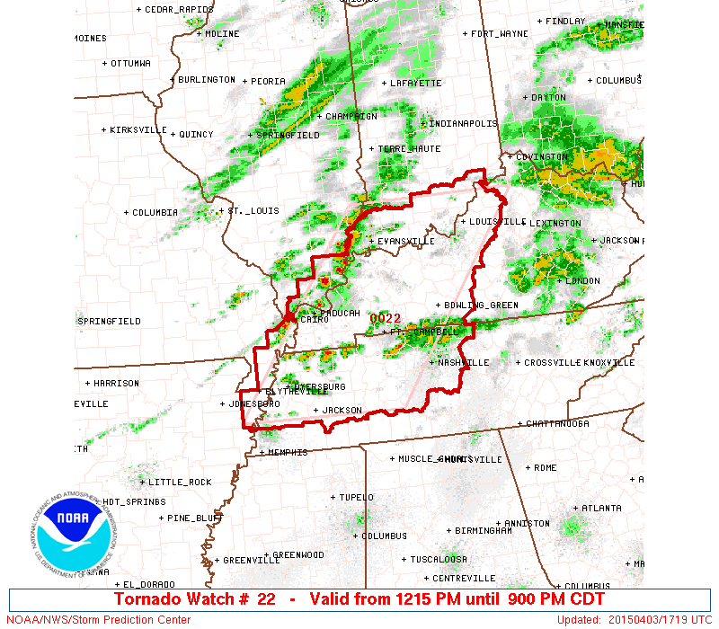
Tornado Watch voor Noord-Texas en Oklahoma
Veel chasers online:
https://tvnweather.com/live
Server is down schijnbaarquote:Op donderdag 16 april 2015 22:58 schreef Rabieluh het volgende:
Nou wil geen een stream meer laden bij mij.
Hmm ja lees het nu ook in de chats.quote:
Klote.
Geen idee waar die kerel zit, iemand in een streamchat kwam ermee.
En ze doen het weerquote:
[..]
Hmm ja lees het nu ook in de chats.
Klote.
Het gaat snel nu
Nog een rare wolk

[ Bericht 6% gewijzigd door #ANONIEM op 17-04-2015 20:08:43 ]

Tornado watch voor oost Colorado en west Kansas
Al twee bevestigde tornado's vandaag in Alabama
Enhanded risk... wel in populated area's


Bij Amarillo Texas
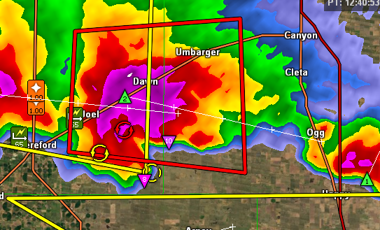
[ Bericht 21% gewijzigd door Houtenbeen op 23-04-2015 00:42:15 ]


Is dat iets nieuws...torcon bedoel ik?quote:
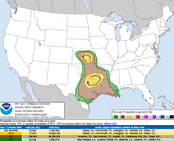
60% kans op een tornado binnen 50 mijlquote:
quote:The Weather Channel Severe Weather Expert, Dr. Greg Forbes (Facebook | Twitter), developed the TOR:CON index to estimate the risk of a tornado on a given day or night near your area.
quote:TOR:CON Value Descriptions
8+ Very high probability of a tornado
6 - High probability of a tornado
4 - Moderate chance of a tornado nearby, but hail and/or high wind gusts possible
2 - Low chance of a tornado, but hail and/or high wind gusts possible
0 - Near-zero chance of a tornado or a severe thunderstorm
The TOR:CON index ranges from 0 to 10. Multiply the value by 10 to get your percentage chance of a tornado within 50 miles of a location. For example, a TOR:CON index of 6 means there's a 60% chance of a tornado within 50 miles of any location in the indicated area.
Volgens mij sinds dit jaar of sinds vorig jaar.
Das best wel ver vooruit voor zon voorspelling. Ben benieuwd wat die dag daar gaat brengen
quote:
Volgens mij komt het andere weer eraan. Ik loop net naar buiten en word ineens heel erg benauwd buiten en de wind begint op te steken.
volgens mij zit je in het verkeerde topic
Ik had er nog niet eerder van gehoord.quote:
Volgens mij heeft The Weather Channel dit zelf samengesteld en aan de hand daarvan hun severe-weather-forecest uitgegeven. Zij hanteren deze schaal, verder niemand volgens mij.
Volgens mij sinds dit jaar of sinds vorig jaar.
Momenteel een tornado watch.


https://www.youtube.com/channel/UCWAN-rRJFLosqgiiIFVpkEQ


twitter:weatherchannel twitterde op dinsdag 05-05-2015 om 20:31:01#TorCon raised to 5 for central #Kansas & central #Oklahoma Wednesday: http://t.co/4Vi6KyncxN #KSwx #OKwx #tornado http://t.co/FRzODFYlyy reageer retweet

twitter:weatherchannel twitterde op woensdag 06-05-2015 om 18:39:35

twitter:weatherchannel twitterde op woensdag 06-05-2015 om 21:35:38

En nu ook een in Oklahoma
http://kfor.com/on-air/live-streaming/

Of gebruik ik een zwaar inferieure site en zeg ik nu iets geks.
Die stream van Lawrence?quote:
Wow, ik keek net op een stream, enorme tornado, aantal viewers ging van 1000 naar 3500, toen scheurden ze er maar vandoor.
Gaat nu richting Moore
Ja!quote:
Nu tornado aan het vormen
Flinke ding