WKN Weer, Klimaat en Natuurrampen
Lees alles over het onstuimige weer op onze planeet, volg orkanen en tornado's, zie hoe vulkanen uitbarsten en hoe Moeder Aarde beeft bij een aardbeving. Alles over de verwoestende kracht van onze planeet en tal van andere natuurverschijnselen.


Prachtige video van de tornado gisteren bij Moore. En gek om te zien hoeveel auto's er nog op die weg reden.
https://www.facebook.com/video.php?v=790527554349697
https://www.facebook.com/video.php?v=790527554349697
Wat gewoon is voor de spin, is chaos voor de vlieg.

Wat een groot ding zegquote:Op donderdag 26 maart 2015 16:26 schreef Pannenkoekenmix het volgende:
Prachtige video van de tornado gisteren bij Moore. En gek om te zien hoeveel auto's er nog op die weg reden.
https://www.facebook.com/video.php?v=790527554349697
Recht zo die gaat, braaf zo die heen.
fok zegquote:
Prachtige video van de tornado gisteren bij Moore. En gek om te zien hoeveel auto's er nog op die weg reden.
https://www.facebook.com/video.php?v=790527554349697
al die "power flashes"
Is de kracht al bekend?
F1-F2 dachten ze gisteren avond op die newstreamquote:Op donderdag 26 maart 2015 16:55 schreef Frutsel het volgende:
[..]
fok zeg
al die "power flashes"
Is de kracht al bekend?

twitter:weatherchannel twitterde op dinsdag 31-03-2015 om 21:51:31 3D cross section of #tornado warned storm in #Arkansasa large #hail core... analysis continues on @weatherchannel http://t.co/Zd4KwrxUVt reageer retweet
 3D cross section of
1chaser maar
https://tvnweather.com/live/
twitter:breakingweather twitterde op dinsdag 31-03-2015 om 22:11:05 Baseball-sized hail reported 3 mi S of Gillett, AR, according to NWS spotter. Radar: http://t.co/0Ll4PyjbAv reageer retweet
 Baseball-sized hail reported 3 mi S of Gillett, AR, according to NWS spotter. Radar:
[ Bericht 5% gewijzigd door Houtenbeen op 01-04-2015 16:12:50 ]


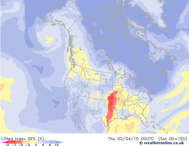
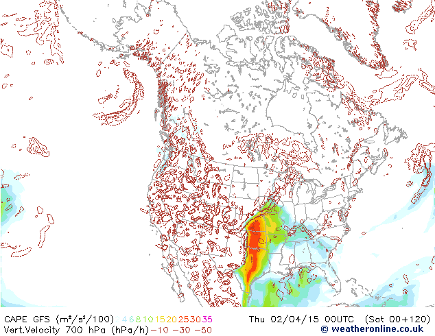
quote:Severe Storms Looming for Early April
The first ten days of April could produce more severe weather than the modest amount racked up so far across the U.S. in 2015. The same upper-level pattern that kept the West warm and the East cold through most of the winter has also kept severe weather to a minimum, as northwest flow and a series of cold fronts pushed warm, unstable air off the U.S. mainland. This year through March 30, we’ve seen a preliminary total of a mere 38 tornadoes, compared to a January-March average over the preceding three years of 163. As of Tuesday morning, NOAA’s Storm Prediction Center had issued just four tornado watches and four severe thunderstorm watches for the year thus far. This compares to a long-term Jan.-Mar. average (1970 – 2014) of around 39 tornado and 24 severe thunderstorm watches, according to SPC’s Greg Carbin.
The 2015 numbers look destined to rise over the next few days, as a major circulation change takes place over North America. The long-prevailing northwest flow is being replaced this week by more zonal (west-to-east) flow, with an embedded upper-level impulse reaching the Midwest on Wednesday and another targeting the Southern Plains on Thursday. A moist low-level air mass is already in place, with dew points close to 60°F from Tulsa, OK, to Birmingham, AL. Surface low pressure generated by the upper-level impulses should continue to pull the moisture pool northward and generate unstable conditions. SPC placed a broad belt from Oklahoma to Georgia under a slight risk of severe weather for Tuesday afternoon and evening, with large hail possible as the moisture continue to flow north.
A large swath of the Great Plains is under an slight risk for Wednesday, from northwest Oklahoma to southern Minnesota, with an slight risk in place for Thursday across part of the Southern Plains and mid-Mississippi Valley. The predominantly west-to-east upper flow combined with southerly low-level flow will enhance vertical wind shear, a key ingredient in the formation of supercell thunderstorms. The main threats appear to be high winds and large hail, although tornadoes can’t be ruled out. As was the case last Wednesday, when F2 tornadoes struck the Tulsa suburb of Sand Springs and the Oklahoma City suburb of Moore, the corridor from Interstate 44 into east central Oklahoma could be a particular focal point for supercell formation by late Thursday. Severe weather may continue into the lower Mississippi Valley on Friday before the associated cold front moves into the Gulf of Mexico.
Forecast models indicate a strong upper-level trough will settle across the Great Basin by early next week, setting the stage for what could be a more extensive multiday round of severe weather beginning as soon as Sunday. A strong surface low should develop over the High Plains by late in the weekend, pulling unstable air back northward across a large area beneath west-southwest upper flow. Strong thunderstorms could spread across the Midwest and South by early next week, with several days of focused severe weather possible.
twitter:weatherchannel twitterde op woensdag 01-04-2015 om 14:41:55 Large #hail & potentially damaging #wind are greatest threats today, but there is a #TorCon of 3 for SE #Nebraska. http://t.co/d3A2wP18mB reageer retweet

twitter:JenCarfagno twitterde op donderdag 02-04-2015 om 15:22:02 Tornado threat today, tonight & tomorrow. @twcMariaLaRosa @GregPostel & I on @weatherchannel from 10a-2p edt. http://t.co/pOhCZwgjz7 reageer retweet
 Tornado threat today, tonight & tomorrow. @
[ Bericht 44% gewijzigd door Houtenbeen op 02-04-2015 16:51:53 ]
twitter:TWCBreaking twitterde op donderdag 02-04-2015 om 22:51:53 Tornado Warning for Laclede County in MO until 4:30 PM CDT http://t.co/qLbtLaTndl reageer retweet
 Tornado Warning for Laclede County in MO until 4:30 PM CDT
[ Bericht 5% gewijzigd door Houtenbeen op 02-04-2015 23:08:54 ]
De onweersbui van Missouri in beeld, er zijn vooralsnog geen/weinig chasers in de buurt.
http://www.ky3.com/weather/cameras/lebanon-camera/25901376

http://www.ky3.com/weather/cameras/lebanon-camera/25901376
Wat gewoon is voor de spin, is chaos voor de vlieg.
Tornadowaarschuwing is ingetrokkenquote:
De onweersbui van Missouri in beeld, er zijn vooralsnog geen/weinig chasers in de buurt.
[ afbeelding ]
http://www.ky3.com/weather/cameras/lebanon-camera/25901376
Maar waarschijnlijk weer snel een nieuwe
twitter:NWSSPC twitterde op donderdag 02-04-2015 om 23:49:36 4:49pm CDT #SPC_MD 0189 concerning severe potential...tornado watch likely, http://t.co/qOWHqqQIQy http://t.co/1KBMFavl6c reageer retweet
 4:49pm CDT
[ Bericht 45% gewijzigd door Houtenbeen op 02-04-2015 23:54:16 ]
twitter:TWCBreaking twitterde op vrijdag 03-04-2015 om 01:52:37 Tornado Warning for Cheyenne County in CO until 6:15 PM MDT http://t.co/bAkCwJ6xLl reageer retweet
twitter:weatherchannel twitterde op vrijdag 03-04-2015 om 02:05:39 BREAKING: #Tornado watch until 2am CDT for parts of KS, MO, AR, OK. Reynolds Wolf is live in #Joplin. http://t.co/SWCI07f3ay reageer retweet

twitter:weatherchannel twitterde op vrijdag 03-04-2015 om 02:11:51 Tornado Warning for Labette County in KS until 8:00 PM CDT http://t.co/hfttWyhKcN reageer retweet
twitter:breakingweather twitterde op vrijdag 03-04-2015 om 02:13:21 Funnel cloud spotted 7 miles E of Cherryvale, KS, trained spotters report: http://t.co/Paa0UNJZ1l reageer retweet

twitter:TWCBreaking twitterde op vrijdag 03-04-2015 om 02:16:22 Tornado Warning for Greeley and Wallace Counties in KS until 6:45 PM MDT http://t.co/PNQTvQ0Bev reageer retweet
twitter:TWCBreaking twitterde op vrijdag 03-04-2015 om 02:16:24 Tornado Warning for Cheyenne County in CO until 6:45 PM MDT http://t.co/QSJJ7BrUFG reageer retweet
[ Bericht 27% gewijzigd door Houtenbeen op 03-04-2015 02:19:07 ]
twitter:weatherchannel twitterde op vrijdag 03-04-2015 om 02:46:50 BREAKING: At 7:43pm CDT a storm chaser reported a #tornado 1 mi N of Labette, KS. Here's proj. path next 45 minutes. http://t.co/UyRfBW0zwV reageer retweet

[ Bericht 16% gewijzigd door Houtenbeen op 03-04-2015 02:54:18 ]
twitter:weatherchannel twitterde op vrijdag 03-04-2015 om 03:10:25 #Tornado warning just north of Joplin, MO within the same county (Jasper) + southern Barton Co. Moving E 40 mph. http://t.co/9hCrUWxV9H reageer retweet

twitter:weatherchannel twitterde op vrijdag 03-04-2015 om 03:14:07 Report: #Tornado sighted in western Cherokee Co, KS at 8:06pm CDT. Bearing down on Columbus KS now (8:12pm CDT). http://t.co/3omIaxPTmf reageer retweet

twitter:weatherchannel twitterde op vrijdag 03-04-2015 om 03:44:43 URGENT 8:43pm CDT: #Tornado warning until 9:30pm for Joplin MO & nearby areas. Reynolds Wolf is there live on air now http://t.co/MwL4ksjLSr reageer retweet


twitter:weatherchannel twitterde op vrijdag 03-04-2015 om 15:38:52 #Tornado threat today
