WKN Weer, Klimaat en Natuurrampen
Lees alles over het onstuimige weer op onze planeet, volg orkanen en tornado's, zie hoe vulkanen uitbarsten en hoe Moeder Aarde beeft bij een aardbeving. Alles over de verwoestende kracht van onze planeet en tal van andere natuurverschijnselen.


Tofquote:Op woensdag 16 juli 2014 14:27 schreef Frutsel het volgende:
Tornado Hunters - Series starts August 2014
http://globalnews.ca/news(...)tured-in-web-series/
Voor de liefhebbers
Op maandag 8 oktober 2012 22:34 schreef LompeHork het volgende:
:W trusten baas!
Op dinsdag 13 augustus 2013 21:29 schreef smegmanus het volgende:
Kudo's voor deze TS +1 positieve note.
:W trusten baas!
Op dinsdag 13 augustus 2013 21:29 schreef smegmanus het volgende:
Kudo's voor deze TS +1 positieve note.


<a href="http://www.vwkweb.nl/" rel="nofollow" target="_blank">[b]Vereniging voor weerkunde en klimatologie[/b]</a>
<a href="http://www.estofex.org/" rel="nofollow" target="_blank">[b]ESTOFEX[/b]</a>
<a href="http://www.estofex.org/" rel="nofollow" target="_blank">[b]ESTOFEX[/b]</a>

Gaaf dat we nu zo'n tornado kunnen ontleden. Daar kunnen die analyses uit Twister niet tegenop.quote:
Genesis and maintenance of a long-track EF5 torna…:

quote:Nicolaus Wegner's Stormscapes 2 video is the most impressive collection of time-lapse severe storm footage I've ever seen. His 7-minute time-lapse compilation of his May - September 2014 adventures in Wyoming, Montana, South Dakota, Nebraska, and Colorado feature an impressive rainbow at 0:40, an incredible orange cumulonimbus at 4:00, a sequence of spectacular funnel clouds and tornadoes beginning at 5:10, and some stunning mammatus clouds at 6:04. Highly recommended.
Deze uit zuid afrika al gezien Vryheid, South Africa | 22-11-2014 ?

You better lose yourself in the music
The moment, you own it, you better never let it go
The moment, you own it, you better never let it go

Wauwquote:
Recht zo die gaat, braaf zo die heen.
quote:Vier doden bij tornado in Mississippi
Vlak voor Kerstmis zijn in de Amerikaanse staat Mississippi vier mensen bij een tornado om het leven gekomen.
De wervelstorm vernielde volgens zender WDAM delen van de plaats Columbia. Twee mensen overleden toen het natuurgeweld hun wooncaravan trof. Twintig mensen raakten gewond, aldus ABC News.
Huizen raakten beschadigd, auto’s werden in de lucht geslingerd en bomen ontworteld. Duizenden mensen zaten tijdelijk zonder stroom.
In twee districten is de noodtoestand uitgeroepen. Ook in de staten Georgia en Louisiana waren er tornado’s.
tornadoseason is coming....
eerste prognoses voor maart zijn er...
http://www.severe-weather(...)a-tornado-potential/
eerste prognoses voor maart zijn er...
http://www.severe-weather(...)a-tornado-potential/
Meldt zich vasttwitter:Frutseltjuh twitterde op woensdag 25-02-2015 om 13:47:39 1 maart start het #tornado seizoen weer in de VS. Join us en volg het seizoen tot in de late uurtjes via de streams.http://t.co/bELhGViLH6 reageer retweet
 1 maart start het
You better lose yourself in the music
The moment, you own it, you better never let it go
The moment, you own it, you better never let it go

Goed bezigquote:Op woensdag 25 februari 2015 13:55 schreef MaryMouse het volgende:
Meldt zich vasttwitter:Frutseltjuh twitterde op woensdag 25-02-2015 om 13:47:39 1 maart start het #tornado seizoen weer in de VS. Join us en volg het seizoen tot in de late uurtjes via de streams.http://t.co/bELhGViLH6 reageer retweet
Vandaag een kleine kans op een tornado... voor de komende dagen verder nog niet echt...quote:Severe Weather Forecast: A Few Severe Storms Possible on Thursday`
A rainy weather pattern will be accompanied by some thunderstorms in the South late this week.
Although widespread severe weather is not expected from the disturbances causing the rain, a few storms could turn severe. This potential threat will mainly stay confined to the Gulf Coast states.
On Thursday, the chance for a few severe storms will be from Louisiana and southeast Arkansas to Mississippi, southern/central Alabama, southwest Georgia and the Florida Panhandle. The main threats are localized damaging wind gusts and perhaps a brief tornado. Heavy rain could also trigger local flash flooding.
Below, we have more details on severe weather threats across the country. You can scroll down the page, or click on these links to jump to your area of interest.
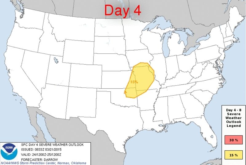
quote:25 Years Ago Today: An Early Outbreak for Tornado Alley
The U.S. is in the midst of an extremely quiet March for severe weather thus far, with no tornadoes and only three reports of large hail. Things looked far different 25 years ago today, as the central Great Plains endured its worst late-winter tornado outbreak on record. From March 11 to 13, 1990, more than 60 tornadoes plowed across Tornado Alley, from north Texas to Iowa. The meteorological setup for this outbreak was classic, but the seasonal timing wasn’t. Never before or since have such strong tornadoes been observed so far northwest so early in the year.
Figure 2. Tracks and intensities of the tornadoes observed on March 13-14, 1990, across the central Plains. Image credit: National Weather Service.
The standouts of this outbreak were two long-lived F5 tornadoes that raked central Kansas on the late afternoon of March 13. The twisters were the first in a family of five generated by a single supercell thunderstorm. The first one developed near the town of Pretty Prairie, west of Wichita, and went on to strike the town of Hesston near the end of its 48-mile path, destroying more than 200 homes. As this F5 tornado narrowed and dissipated, a new one formed about a mile to its north within the same larger-scale circulation. An analysis by eminent tornado scientist Theodore “Ted” Fujita found that the two twisters likely rotated around a common axis as the first one dissipated and the second one expanded, delivering a glancing blow to the town of Goessel along its 22-mile path. There have been only four other days since 1950--and none so early in the year--with at least two tornadoes producing F5 or EF5 damage (May 25, 1955; May 15, 1968; April 3, 1974, and April 27, 2011).
Despite the strength and longevity of the Hesston and Goessel tornadoes, they caused only two fatalities. The low death toll becomes even more impressive when you consider the limits of communication and warning technology circa 1990. At that time, the National Weather Service office in Wichita still relied on a 1957-vintage, pre-Doppler weather radar that tracked precipitation but provided no wind data. ”We would draw what we saw on a reflection plotter and then trace contours on a paper map overlay to locate a storm geographically,” recalled Randy Steadham, who was filling in as meteorologist in charge of the Wichita NWS office. The emergence of a classic hook echo on radar, plus a number of eyewitness reports, helped the office to track the storm closely and issue updates roughly every 9 minutes, which made it to the public via radio, TV, and NOAA Weather Radio.

quote:Tornado season is off to a slow start
But March has been known for its deadly and notable severe weather outbreaks in the past.
Not a single tornado has been reported to the National Weather Service so far in March, which typically marks the first month of severe weather season in the Plains and Southeast. According to the Weather Channel’s severe expert Greg Forbes, the only other year since 1950 that there have been zero tornado reports in the first half of March was 1969.
Just seven severe weather reports — two for large hail and five for strong winds — have been reported so far this month. From 1991 to 2010, an average of 80 tornadoes were reported in the month of March across the United States, with the largest number being reported in the South.
January and February were also extremely quiet, weather.com reports:
As of March 12, only 27 tornadoes had been documented across the nation, according to statistics from The Weather Channel severe weather expert Dr. Greg Forbes. This is the slowest start to the year, tornado-wise, since the 21 tornadoes recorded through March 12, 2003.
February was eerily quiet, with only two tornadoes reported during the month; one in California, the other in Florida. According to statistics kept by Dr. Forbes, only three other Februaries since 1950 saw two or fewer tornadoes in the U.S.: 2010 (1), 2002 (2) and 1964 (2).
Greg Carbin, warning coordination meteorologist at the Storm Prediction Center (SPC) noted only four tornado watches were issued by the SPC in January and February combined, the fewest in the year’s first two months since 1985 required only two tornado watches.
momenteel

Never Stop Exploring!
Life begins at the end of your comfort zone!
Follow me on Twitter: https://twitter.com/EdwinKr83 Instagram: https://www.instagram.com/edwinkr83/
Life begins at the end of your comfort zone!
Follow me on Twitter: https://twitter.com/EdwinKr83 Instagram: https://www.instagram.com/edwinkr83/
twitter:weatherchannel twitterde op dinsdag 24-03-2015 om 23:48:25 3D radar shows big #Hail building in these 2 storms just SW of #Springfield MO #mowx #severe http://t.co/hvTucqlTia reageer retweet
 3D radar shows big
twitter:TWCBreaking twitterde op woensdag 25-03-2015 om 00:55:59 Tornado Warning for Boone and Marion Counties in AR until 7:30 PM CDT http://t.co/ruJjPGx9Ua reageer retweet
 Tornado Warning for Boone and Marion Counties in AR until 7:30 PM CDT
[ Bericht 5% gewijzigd door Houtenbeen op 25-03-2015 01:03:26 ]
Bronquote:Another disturbance will move into the Plains on Wednesday bringing the risk for large hail, damaging winds and isolated tornadoes.
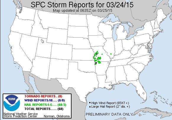
The first severe thunderstorm watch of 2015 was issued over parts of four states as the first threat of organized springtime severe weather targeted the nation's midsection on Tuesday. There were more than 60 reports of hail between 1 and 2 inches in diameter on Tuesday night.
In what has been a very quiet year for severe weather, NOAA's Storm Prediction Center had issued only four watches this year before Tuesday's watch. All of those were tornado watches – three in January and one in February.
Wednesday: Scattered severe thunderstorms should again break out by mid-late afternoon, this time near the intersection of a bulge in a surface dryline and cold front in Oklahoma, north Texas and southeast Kansas. During the evening, this activity is expected to form a squall line and push across central and southern Missouri and at least northern Arkansas. Damaging winds and large hail will again be the primary threats, but a tornado cannot be ruled out.
Kan nog steeds vandaag

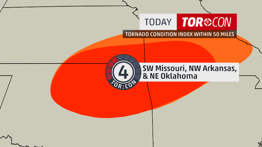
twitter:weatherchannel twitterde op woensdag 25-03-2015 om 12:46:55 #TorCon of 4 today for SW #Missouri, NW #Arkansas & NE #Oklahoma. Latest forecast: http://t.co/RgUUdZYVO7 #tornado http://t.co/ObPzNkMzIA reageer retweet


moderate risk idd. Kan laat worden vanavond.quote:
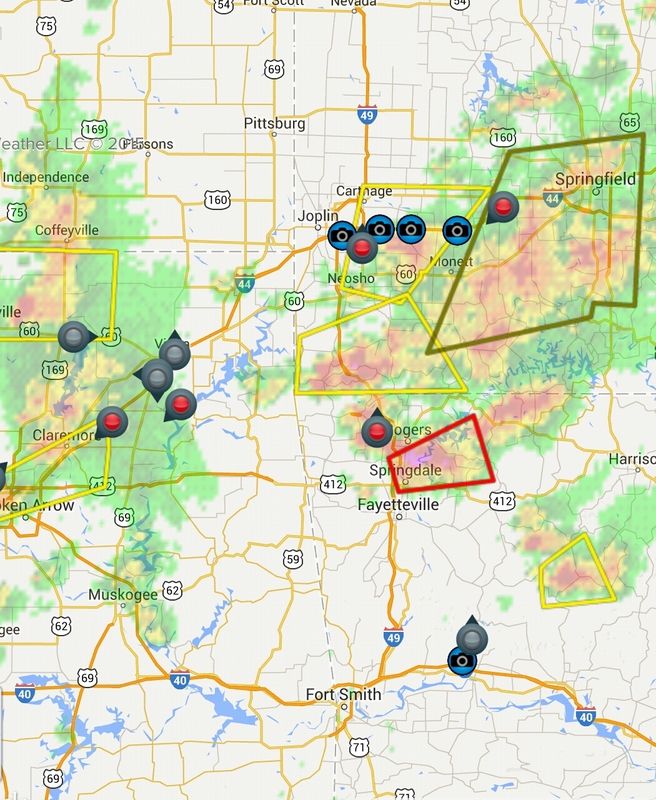
Nieuwe update: Kans wordt ineens een stuk groter
[ afbeelding ]
Tis voornamelijk voor grote hagel, maar een isolated tornado event is mogelijkquote:Op woensdag 25 maart 2015 15:01 schreef aloa het volgende:
[..]
moderate risk idd. Kan laat worden vanavond.
twitter:NWStulsa twitterde op woensdag 25-03-2015 om 17:11:29 We have upped our SVR and TOR probs based on latest data. Expect storms to develop in NE OK 3-4 PM. #okwx #arwx http://t.co/zfLjV4uR4k reageer retweet
 We have upped our SVR and TOR probs based on latest data. Expect storms to develop in NE OK 3-4 PM.

Eerste hagel wordt ook gemeld nu net boven het gebied met moderate risk. Daar ontstaan al zware onweersbuien.
[ Bericht 20% gewijzigd door #ANONIEM op 25-03-2015 18:49:15 ]
[ Bericht 20% gewijzigd door #ANONIEM op 25-03-2015 18:49:15 ]
Schitterende buien momenteel.quote:
zit al een chaser bij joplin te streamen
twitter:TWCBreaking twitterde op woensdag 25-03-2015 om 22:51:17 Tornado Warning for Benton, Carroll, Madison and Washington Counties in AR until 5:15 PM CDT http://t.co/wcWobL4yeV reageer retweet
twitter:TWCBreaking twitterde op woensdag 25-03-2015 om 23:13:45 Tornado Warning for Creek, Osage, Pawnee and Tulsa Counties in OK until 5:45 PM CDT http://t.co/SJIMFIGLJv reageer retweet

twitter:weatherchannel twitterde op woensdag 25-03-2015 om 23:26:39 #BREAKING: Spotters confirm large tornado at 5:21p near Westport, Okla. moving E toward city of Tulsa. Take cover!! http://t.co/oOaDD3xuAG reageer retweet


Dat stadje word wel erg vaak belaagd door tornado's, vorg jaar ook al.quote:
http://kfor.com/on-air/live-streaming/
Tornado in Moore
🐱
twitter:abcnewswx twitterde op donderdag 26-03-2015 om 02:04:17 JUST IN: Tulsa Co. Sheriff's Office: 1 dead, others injured after tornado-warned storm moves through Sand Springs, Oklahoma. reageer retweet
 JUST IN: Tulsa Co. Sheriff's Office: 1 dead, others injured after tornado-warned storm moves through Sand Springs, Oklahoma.
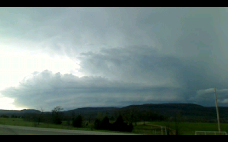
Foto van de tornado in post 141
[ Bericht 5% gewijzigd door Houtenbeen op 26-03-2015 02:43:37 ]
twitter:weatherchannel twitterde op donderdag 26-03-2015 om 03:06:56 Earlier this evening in Catoosa, OK. That is #hail, not snow. MT @kylievalene @weatherchannel This is our backyard! http://t.co/KD9dCswVEf reageer retweet


Prachtige video van de tornado gisteren bij Moore. En gek om te zien hoeveel auto's er nog op die weg reden.
https://www.facebook.com/video.php?v=790527554349697
https://www.facebook.com/video.php?v=790527554349697
Wat gewoon is voor de spin, is chaos voor de vlieg.
Wat een groot ding zegquote:Op donderdag 26 maart 2015 16:26 schreef Pannenkoekenmix het volgende:
Prachtige video van de tornado gisteren bij Moore. En gek om te zien hoeveel auto's er nog op die weg reden.
https://www.facebook.com/video.php?v=790527554349697
Recht zo die gaat, braaf zo die heen.
fok zegquote:
Prachtige video van de tornado gisteren bij Moore. En gek om te zien hoeveel auto's er nog op die weg reden.
https://www.facebook.com/video.php?v=790527554349697
al die "power flashes"
Is de kracht al bekend?
F1-F2 dachten ze gisteren avond op die newstreamquote:
[..]
fok zeg
al die "power flashes"
Is de kracht al bekend?

twitter:weatherchannel twitterde op dinsdag 31-03-2015 om 21:51:31 3D cross section of #tornado warned storm in #Arkansasa large #hail core... analysis continues on @weatherchannel http://t.co/Zd4KwrxUVt reageer retweet

1chaser maar
https://tvnweather.com/live/
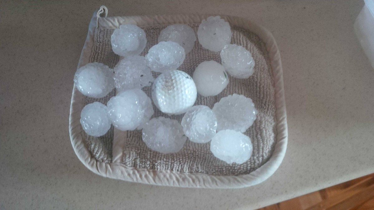
twitter:breakingweather twitterde op dinsdag 31-03-2015 om 22:11:05 Baseball-sized hail reported 3 mi S of Gillett, AR, according to NWS spotter. Radar: http://t.co/0Ll4PyjbAv reageer retweet
 Baseball-sized hail reported 3 mi S of Gillett, AR, according to NWS spotter. Radar:
[ Bericht 5% gewijzigd door Houtenbeen op 01-04-2015 16:12:50 ]


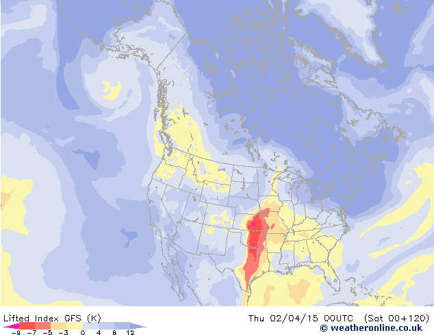
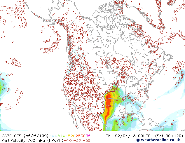
quote:Severe Storms Looming for Early April
The first ten days of April could produce more severe weather than the modest amount racked up so far across the U.S. in 2015. The same upper-level pattern that kept the West warm and the East cold through most of the winter has also kept severe weather to a minimum, as northwest flow and a series of cold fronts pushed warm, unstable air off the U.S. mainland. This year through March 30, we’ve seen a preliminary total of a mere 38 tornadoes, compared to a January-March average over the preceding three years of 163. As of Tuesday morning, NOAA’s Storm Prediction Center had issued just four tornado watches and four severe thunderstorm watches for the year thus far. This compares to a long-term Jan.-Mar. average (1970 – 2014) of around 39 tornado and 24 severe thunderstorm watches, according to SPC’s Greg Carbin.
The 2015 numbers look destined to rise over the next few days, as a major circulation change takes place over North America. The long-prevailing northwest flow is being replaced this week by more zonal (west-to-east) flow, with an embedded upper-level impulse reaching the Midwest on Wednesday and another targeting the Southern Plains on Thursday. A moist low-level air mass is already in place, with dew points close to 60°F from Tulsa, OK, to Birmingham, AL. Surface low pressure generated by the upper-level impulses should continue to pull the moisture pool northward and generate unstable conditions. SPC placed a broad belt from Oklahoma to Georgia under a slight risk of severe weather for Tuesday afternoon and evening, with large hail possible as the moisture continue to flow north.
A large swath of the Great Plains is under an slight risk for Wednesday, from northwest Oklahoma to southern Minnesota, with an slight risk in place for Thursday across part of the Southern Plains and mid-Mississippi Valley. The predominantly west-to-east upper flow combined with southerly low-level flow will enhance vertical wind shear, a key ingredient in the formation of supercell thunderstorms. The main threats appear to be high winds and large hail, although tornadoes can’t be ruled out. As was the case last Wednesday, when F2 tornadoes struck the Tulsa suburb of Sand Springs and the Oklahoma City suburb of Moore, the corridor from Interstate 44 into east central Oklahoma could be a particular focal point for supercell formation by late Thursday. Severe weather may continue into the lower Mississippi Valley on Friday before the associated cold front moves into the Gulf of Mexico.
Forecast models indicate a strong upper-level trough will settle across the Great Basin by early next week, setting the stage for what could be a more extensive multiday round of severe weather beginning as soon as Sunday. A strong surface low should develop over the High Plains by late in the weekend, pulling unstable air back northward across a large area beneath west-southwest upper flow. Strong thunderstorms could spread across the Midwest and South by early next week, with several days of focused severe weather possible.
twitter:weatherchannel twitterde op woensdag 01-04-2015 om 14:41:55 Large #hail & potentially damaging #wind are greatest threats today, but there is a #TorCon of 3 for SE #Nebraska. http://t.co/d3A2wP18mB reageer retweet

twitter:JenCarfagno twitterde op donderdag 02-04-2015 om 15:22:02 Tornado threat today, tonight & tomorrow. @twcMariaLaRosa @GregPostel & I on @weatherchannel from 10a-2p edt. http://t.co/pOhCZwgjz7 reageer retweet
 Tornado threat today, tonight & tomorrow. @
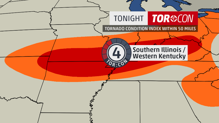
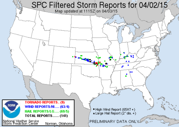
[ Bericht 44% gewijzigd door Houtenbeen op 02-04-2015 16:51:53 ]
twitter:TWCBreaking twitterde op donderdag 02-04-2015 om 22:51:53 Tornado Warning for Laclede County in MO until 4:30 PM CDT http://t.co/qLbtLaTndl reageer retweet

[ Bericht 5% gewijzigd door Houtenbeen op 02-04-2015 23:08:54 ]
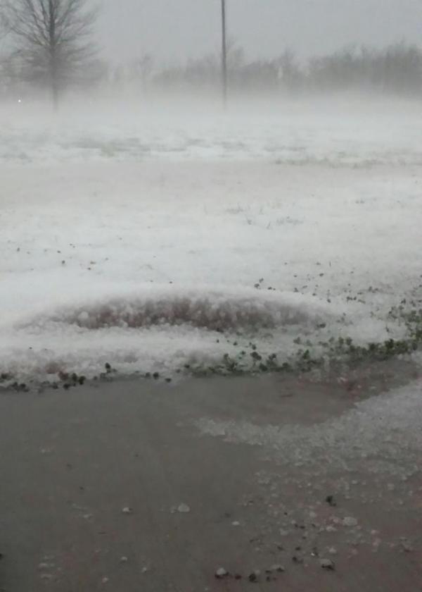
De onweersbui van Missouri in beeld, er zijn vooralsnog geen/weinig chasers in de buurt.
http://www.ky3.com/weather/cameras/lebanon-camera/25901376

http://www.ky3.com/weather/cameras/lebanon-camera/25901376
Wat gewoon is voor de spin, is chaos voor de vlieg.
Tornadowaarschuwing is ingetrokkenquote:
De onweersbui van Missouri in beeld, er zijn vooralsnog geen/weinig chasers in de buurt.
[ afbeelding ]
http://www.ky3.com/weather/cameras/lebanon-camera/25901376
Maar waarschijnlijk weer snel een nieuwe
twitter:NWSSPC twitterde op donderdag 02-04-2015 om 23:49:36 4:49pm CDT #SPC_MD 0189 concerning severe potential...tornado watch likely, http://t.co/qOWHqqQIQy http://t.co/1KBMFavl6c reageer retweet
 4:49pm CDT
[ Bericht 45% gewijzigd door Houtenbeen op 02-04-2015 23:54:16 ]
twitter:TWCBreaking twitterde op vrijdag 03-04-2015 om 01:52:37 Tornado Warning for Cheyenne County in CO until 6:15 PM MDT http://t.co/bAkCwJ6xLl reageer retweet
twitter:weatherchannel twitterde op vrijdag 03-04-2015 om 02:05:39 BREAKING: #Tornado watch until 2am CDT for parts of KS, MO, AR, OK. Reynolds Wolf is live in #Joplin. http://t.co/SWCI07f3ay reageer retweet

twitter:weatherchannel twitterde op vrijdag 03-04-2015 om 02:11:51 Tornado Warning for Labette County in KS until 8:00 PM CDT http://t.co/hfttWyhKcN reageer retweet
twitter:breakingweather twitterde op vrijdag 03-04-2015 om 02:13:21 Funnel cloud spotted 7 miles E of Cherryvale, KS, trained spotters report: http://t.co/Paa0UNJZ1l reageer retweet

twitter:TWCBreaking twitterde op vrijdag 03-04-2015 om 02:16:22 Tornado Warning for Greeley and Wallace Counties in KS until 6:45 PM MDT http://t.co/PNQTvQ0Bev reageer retweet
twitter:TWCBreaking twitterde op vrijdag 03-04-2015 om 02:16:24 Tornado Warning for Cheyenne County in CO until 6:45 PM MDT http://t.co/QSJJ7BrUFG reageer retweet
[ Bericht 27% gewijzigd door Houtenbeen op 03-04-2015 02:19:07 ]
twitter:weatherchannel twitterde op vrijdag 03-04-2015 om 02:46:50 BREAKING: At 7:43pm CDT a storm chaser reported a #tornado 1 mi N of Labette, KS. Here's proj. path next 45 minutes. http://t.co/UyRfBW0zwV reageer retweet

[ Bericht 16% gewijzigd door Houtenbeen op 03-04-2015 02:54:18 ]
twitter:weatherchannel twitterde op vrijdag 03-04-2015 om 03:10:25 #Tornado warning just north of Joplin, MO within the same county (Jasper) + southern Barton Co. Moving E 40 mph. http://t.co/9hCrUWxV9H reageer retweet

twitter:weatherchannel twitterde op vrijdag 03-04-2015 om 03:14:07 Report: #Tornado sighted in western Cherokee Co, KS at 8:06pm CDT. Bearing down on Columbus KS now (8:12pm CDT). http://t.co/3omIaxPTmf reageer retweet

twitter:weatherchannel twitterde op vrijdag 03-04-2015 om 03:44:43 URGENT 8:43pm CDT: #Tornado warning until 9:30pm for Joplin MO & nearby areas. Reynolds Wolf is there live on air now http://t.co/MwL4ksjLSr reageer retweet


twitter:weatherchannel twitterde op vrijdag 03-04-2015 om 15:38:52 #Tornado threat today

twitter:NWSSPC twitterde op vrijdag 03-04-2015 om 18:58:08 11:58am CDT #SPC_MD 0200 concerning severe potential...tornado watch likely, http://t.co/r7I05HG26h http://t.co/R3W9PSqQpS reageer retweet


twitter:NWSSPC twitterde op vrijdag 03-04-2015 om 19:20:07 12:20pm CDT #SPC_Watch WW 22 TORNADO AR IL IN KY MO TN 031715Z - 040200Z, http://t.co/7lIyHjDdtj http://t.co/hxPVqw6pKU reageer retweet
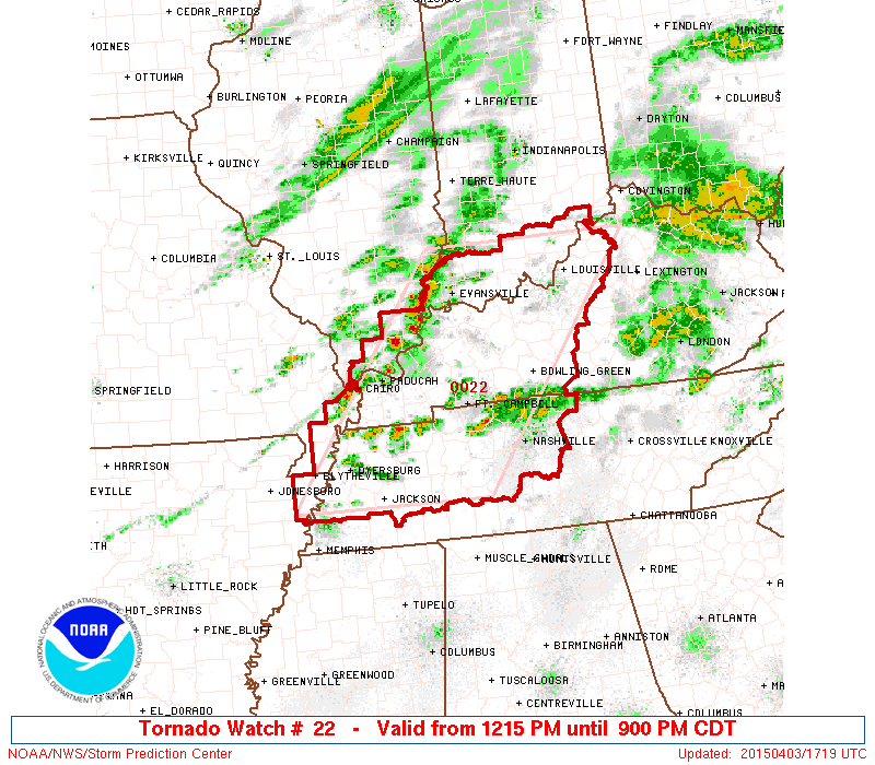
[ Bericht 29% gewijzigd door Houtenbeen op 03-04-2015 19:23:47 ]
twitter:weatherchannel twitterde op zaterdag 04-04-2015 om 00:02:52 #Tornado warning until 5:30pm CDT for east side of #Nashville & eastern suburbs. Based on radar. Take cover. http://t.co/PB1HtgSA7Q reageer retweet

twitter:weatherchannel twitterde op zaterdag 04-04-2015 om 02:52:39 7:51pm CT: CONFIRMED #tornado located north of Moores Mill near New Market, #Alabama, moving east at 50 mph. #ALwx http://t.co/Y5aDiPtkpT reageer retweet


Alleen geen chasers daar
Eens zien wat het gaat worden...quote:
https://twitter.com/AviWxChasers/status/584357076471713794
outbreak coming up?
100.000 katjes
Fuck the EBU!
Fuck the EBU!
quote:
https://twitter.com/AviWxChasers/status/584357076471713794
outbreak coming up?
twitter:breakingweather twitterde op maandag 06-04-2015 om 00:30:38 A dangerous outbreak of severe weather will strike the Central US Wednesday & Thursday. http://t.co/1UcgSWm7cg reageer retweet

twitter:weatherchannel twitterde op dinsdag 07-04-2015 om 18:55:01 #TorCon of 3 today for central #Missouri; our latest forecast: http://t.co/ZQTeMs94xy #tornado #severe #storms #MOwx http://t.co/UCnOTbNdla reageer retweet

The storms on Wednesday could produce a few tornadoes that are on the ground for a considerable amount of time. Tornadoes of this nature can be especially strong and destructive.
http://www.accuweather.co(...)r-outbrea-1/45123731

http://www.accuweather.co(...)r-outbrea-1/45123731
twitter:TWCBreaking twitterde op dinsdag 07-04-2015 om 21:50:23 Tornado Warning for Spencer and Warrick Counties in IN until 3:15 PM CDT http://t.co/FvDDa6HJz0 reageer retweet
twitter:weatherchannel twitterde op dinsdag 07-04-2015 om 21:54:37 JUST IN: Santa Claus is under a #tornado warning until 3:15pm CDT. Santa Claus, Indiana, that is. http://t.co/WrznvzclGj reageer retweet

https://tvnweather.com/live
Nu zelfs voor California
[ Bericht 4% gewijzigd door Houtenbeen op 08-04-2015 00:49:57 ]
twitter:weatherchannel twitterde op woensdag 08-04-2015 om 00:25:53 #Tornado Warning in N. CA for central Glenn County until 3:45p PDT. Seek shelter if in path! #CAwx #severe #storm http://t.co/05UAHwYH6Q reageer retweet

[ Bericht 4% gewijzigd door Houtenbeen op 08-04-2015 00:49:57 ]
twitter:weatherchannel twitterde op woensdag 08-04-2015 om 02:15:00 Greater #severe threat Wednesday with #TorCons up to 5 for E. #Kansas & N./central #Oklahoma: http://t.co/w1qUIT7Kw0 http://t.co/6IozLKrV0q reageer retweet


quote:SRN AND CNTRL PLAINS THROUGH THE LOWER MO VALLEY...
PARTIALLY MODIFIED GULF AIR IS IN PLACE OVER THE SRN PLAINS...AND
LOW-LEVEL LOW TO MID 60S F DEWPOINTS SHOULD CHARACTERIZE MUCH OF THE
WARM SECTOR DURING THE AFTERNOON. THE 00Z WED RAOBS INDICATE AN EML
WITH STEEP LAPSE RATES HAS ALREADY ADVECTED ABOVE MUCH OF THIS
REGION...AND DIABATIC WARMING OF THE BOUNDARY LAYER SHOULD BOOST
MLCAPE TO 2500-3500 J/KG WEDNESDAY AFTERNOON. ELEVATED STORMS MAY
DEVELOP EARLY IN THE PERIOD NORTH OF THE STALLED FRONT FROM ERN KS
INTO MO...AND SOME OF THIS ACTIVITY MAY POSE A THREAT FOR LARGE
HAIL. CURRENT INDICATIONS ARE THAT MOST OF THE WARM SECTOR WILL
REMAIN CAPPED MUCH OF THE DAY. SOME MODEL SOLUTIONS INITIATE STORMS
BY EARLY AFTERNOON FROM NRN TX INTO OK...BUT THIS ACTIVITY MIGHT BE
MID-LEVEL CONVECTION ROOTED ABOVE THE CAP AND DEVELOPING IN RESPONSE
TO THE SRN-STREAM JET STREAK.
CURRENT THINKING IS THAT SFC-BASED STORMS WILL INITIATE ALONG THE
DRYLINE-FRONT INTERSECTION OVER NCNTRL OK OR SCNTRL KS BY LATE
AFTERNOON...WHILE OTHER MORE ISOLATED ACTIVITY MAY DEVELOP FARTHER
SW FROM THE ERN TX PANHANDLE INTO WRN TX WITHIN ZONE OF DEEP MIXING
ALONG THE DRYLINE. DEEP-LAYER SHEAR PROFILES WILL STRENGTHEN TO
40-50 KT WITH APPROACH OF THE MID-LEVEL JET STREAK SUPPORTIVE OF
SUPERCELLS CAPABLE OF PRODUCING VERY LARGE HAIL. THREAT FOR
TORNADOES /A COUPLE OF WHICH COULD BE STRONG/ WILL ALSO INCREASE BY
LATE AFTERNOON INTO THE EARLY EVENING AS THE LLJ STRENGTHENS IN
ASSOCIATION WITH DEEPENING LEE LOW. ACTIVITY IS EXPECTED TO DEVELOP
NEWD THROUGH THE MID MS VALLEY AREA DURING THE EVENING WITH A
CONTINUED THREAT FOR LARGE HAIL...DAMAGING WIND AND A FEW TORNADOES.
GIVEN THE POTENTIAL FOR SIGNIFICANT SEVERE...AN UPGRADE TO MODERATE
RISK MIGHT BE NEEDED IN LATER UPDATES ONCE MORE
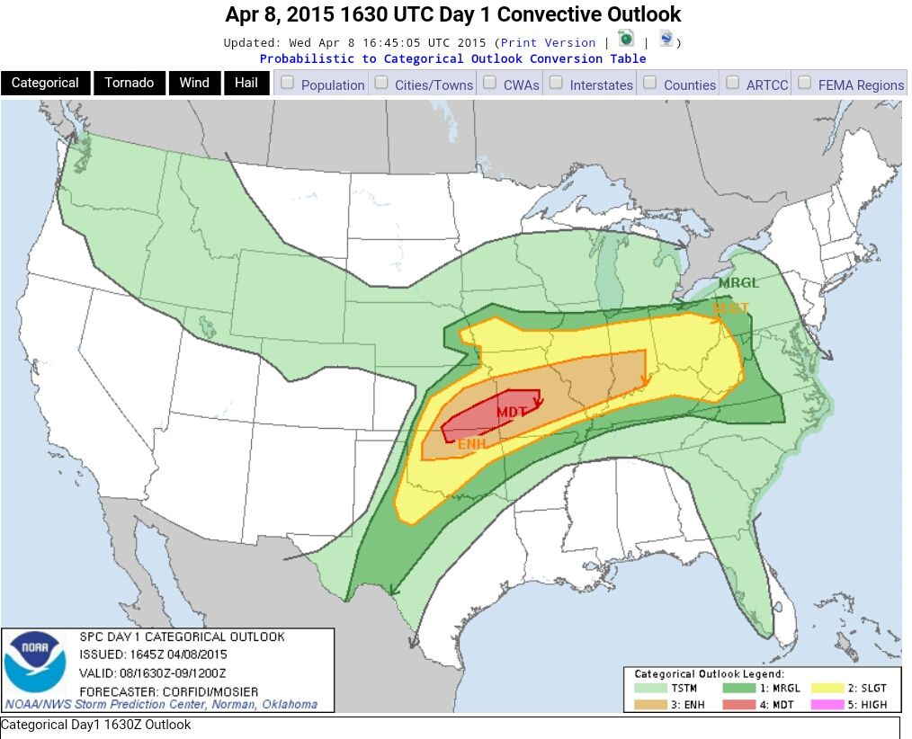
De torcon voor vandaag is omhoog gegaan naar 6.
twitter:jjabraham twitterde op woensdag 08-04-2015 om 18:05:24 Hey #MidMO: @DrGregForbes just raised the TOR:CON to a 6 in central MO. 60% chance of a tornado within 50 miles. Stay safe today! #CoMO reageer retweet
 Hey
Hey quote:Wednesday, April 8, 2015
Scattered severe thunderstorms in WV, central and south OH, central and south IN, central and south IL, north KY, MO, east and south-central KS, OK, except for panhandle, northwest TX near Childress, Abilene, and Wichita Falls, northwest AR. TOR:CON - 6 central and south MO; 5 southeast KS, north-central OK; 4 southwest OK; 3 rest of area above.
Wednesday Night, April 8, 2015
Severe thunderstorms in central and south IN, central and south IL, west KY, north and west AR, MO, south IA, east and south-central KS, OK except for panhandle, central TX. TOR:CON - 6 central and southwest MO and southeast KS; 5 central and northeast OK; 4 central TX; 3 rest of area.
twitter:TWCBreaking twitterde op woensdag 08-04-2015 om 22:11:09 Tornado Warning for Brown and Monroe Counties in IN until 4:45 PM EDT http://t.co/qufScW2JnY reageer retweet
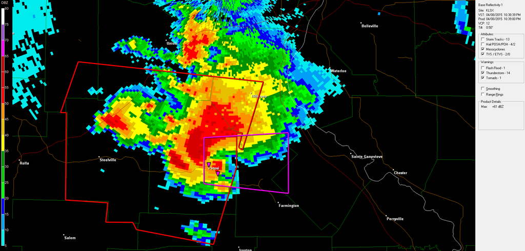
twitter:TWCBreaking twitterde op woensdag 08-04-2015 om 22:20:32 Tornado Warning for Jefferson, St. Francois and Washington Counties in MO until 3:45 PM CDT http://t.co/o2lJwnbObN reageer retweet
[ Bericht 33% gewijzigd door Houtenbeen op 08-04-2015 22:21:15 ]

Never Stop Exploring!
Life begins at the end of your comfort zone!
Follow me on Twitter: https://twitter.com/EdwinKr83 Instagram: https://www.instagram.com/edwinkr83/
Life begins at the end of your comfort zone!
Follow me on Twitter: https://twitter.com/EdwinKr83 Instagram: https://www.instagram.com/edwinkr83/
Die live map met daarop de chasers is niet actief?
*edit: aha https://tvnweather.com/live/
en
http://www.chasertv.com/
*edit: aha https://tvnweather.com/live/
en
http://www.chasertv.com/
Recht zo die gaat, braaf zo die heen.
Via hier, https://www.youtube.com/channel/UCWAN-rRJFLosqgiiIFVpkEQ , is oa Brandon Ivey te volgen. Jammer genoeg problemen met zijn auto. Op de andere stream zijn ze rustig aan het afwachten met een aantal chasers (Tony Laubach, Skip Talbot)
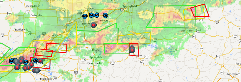
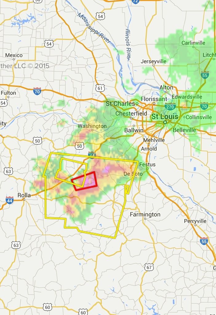
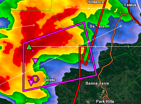
Waarschijnlijk een tornado op de grond? Lijkt wel zo op de radar:
Waarschijnlijk een tornado op de grond? Lijkt wel zo op de radar: