WKN Weer, Klimaat en Natuurrampen
Lees alles over het onstuimige weer op onze planeet, volg orkanen en tornado's, zie hoe vulkanen uitbarsten en hoe Moeder Aarde beeft bij een aardbeving. Alles over de verwoestende kracht van onze planeet en tal van andere natuurverschijnselen.


Pilger, sorry, heb het steeds verkeerd verstaan.quote:
De stream van Midwest Storm chasers laat nu ook de twee tornado's zien.
Wat gewoon is voor de spin, is chaos voor de vlieg.
Daar hoorde ik ook wat berichten van en dat er veel verwondingen zijn. Het zier er ernstig uit.quote:Op maandag 16 juni 2014 23:42 schreef Frutsel het volgende:
Heftig...stadje kon idd wel eens "wiped out" zijn
Wat gewoon is voor de spin, is chaos voor de vlieg.

Bizarre foto zegquote:Op maandag 16 juni 2014 23:31 schreef Pannenkoekenmix het volgende:
15% op z'n meest. Een uur terug ongeveer is er een PDS waarschuwing afgegeven. Het lijkt erop dat het stadje Pilgrim getroffen is door een tornado.
[ afbeelding ]
Schade in Pilgrim met 2 tornado's op de achtergrond.
[ afbeelding ]
Zou haast denken: te echt... must be photoshop


Daniel Shaw heeft het over EF 4 schade aan gebouwen die hij gezien heeft.
Wat gewoon is voor de spin, is chaos voor de vlieg.


[ Bericht 18% gewijzigd door PKM op 17-06-2014 00:13:58 ]
Wat gewoon is voor de spin, is chaos voor de vlieg.

De lucht kolkt boven Sioux City. De verwachting is dat daar misschien nieuwe tornado's vormen.
Schadefoto uit Pilger
[ Bericht 46% gewijzigd door PKM op 17-06-2014 00:54:03 ]
Schadefoto uit Pilger

[ Bericht 46% gewijzigd door PKM op 17-06-2014 00:54:03 ]
Wat gewoon is voor de spin, is chaos voor de vlieg.


Het is nog vroeg in de middag in Iowa en er staan al 2 tornado warnings.
Wat gewoon is voor de spin, is chaos voor de vlieg.

quote:Tornado Smithfield may be deadliest in NY state history
The storm that killed four people in Smithfield, New York, on Tuesday evening may have been the deadliest tornado in New York state history.
A survey team from the National Weather Service in Binghamton, New York, determined that a tornado destroyed the homes where four people were killed in this upstate New York town.
The survey crew completed its survey Wednesday afternoon, concluding that the tornado packed winds of up to 125 mph, earning it an EF2 rating on the Enhanced Fujita Scale.
Deadliest Tornado Status Disputed
The status of New York's deadliest tornado is in dispute. According to official data from the National Oceanic and Atmospheric Administration, that dubious distinction belongs to a storm that killed nine children at the East Coldenham Elementary School in Orange County on Nov. 16, 1989.
The children died when a wall fell on them during the storm. While the National Weather Service concluded that the damage was caused by an F1 tornado, the pioneer of modern tornado survey techniques disagreed.
Dr. Theodore Fujita surveyed the damage from that event and concluded that a microburst, rather than a tornado, caused the damage. His findings were later rejected by the Governor of New York, and NOAA continues to list the event as a tornado in its Storm Data catalog.
(MORE: Worst November Tornado Outbreaks)
Even in the immediate aftermath of the 1989 tragedy, there was disagreement over what caused it. A Nov. 17, 1989 article in the New York Times called it a "hurricane-force gust of wind" while noting that several eyewitnesses and the county police believed it to be a tornado.
According to tornado historian Tom Grazulis, the next-deadliest tornadoes on record in New York history each killed three people and each occurred over 100 years ago:
A tornado moved from Onondaga Lake to just north of Syracuse on Sept. 15, 1912, killing three and injuring 40.
A tornado slashed through the town of Willing in Allegany County on Sept. 28, 1884. Three died and 31 were hurt.
Tuesday's tornado will go into NOAA's record books as the second-deadliest tornado in New York history. But in the view of some meteorologists, the Smithfield tornado qualifies the deadliest in state history.
Governor Sees "Pattern of Extreme Weather"
In a press conference Wednesday, Governor Andrew Cuomo lamented the number of disasters during his tenure in office.
"Unfortunately, in my three and a half years as governor, I've seen too many disasters," Cuomo said. "And I've been in settings like this too often."
Citing 11 federally declared disasters in his tenure, Cuomo added, "There is a pattern of extreme weather that is different. We're seeing things that we've never seen. We see floods where homes that have been dry for 100 years get hit with floods and get totally destroyed."
Cuomo said the state had begun citizen preparation training sessions to cope with the spate of natural disasters. "We don't get tornadoes in New York, right? Anyone will tell you that. Well, we do now."
In fact, according to The Weather Channel severe weather expert Dr. Greg Forbes, 418 tornadoes struck the Empire State from 1950 through 2012, ranking New York 30th among all states in total tornadoes, and 36th in tornadoes per square mile.
Is New York Actually Seeing More Tornadoes?
New York's tornado density was 2.10 tornadoes per 10,000 square miles per year from 2000 to 2012, a 71-percent increase from 1.22 in the 1950-1999 period.
However, improved reporting methods have vastly increased the annual number of reported tornadoes in the United States. Many experts believe there is no long-term upward or downward trend in the actual number of tornadoes in the U.S., noting that reports of the most obvious, powerful tornadoes have not shown any upward trend.
For the nation as a whole, the tornado density went from 2.30 in the second half of the last century to 3.66 for 2000-2012, an increase of 59 percent. New York's tornado counts are growing slightly faster than the nation as a whole, but it is unclear whether that is due to increased tornado activity above and beyond the improved reporting system.

Tornado Hunters - Series starts August 2014
http://globalnews.ca/news(...)tured-in-web-series/
Voor de liefhebbers
http://globalnews.ca/news(...)tured-in-web-series/
Voor de liefhebbers
Tofquote:
Tornado Hunters - Series starts August 2014
http://globalnews.ca/news(...)tured-in-web-series/
Voor de liefhebbers
Op maandag 8 oktober 2012 22:34 schreef LompeHork het volgende:
:W trusten baas!
Op dinsdag 13 augustus 2013 21:29 schreef smegmanus het volgende:
Kudo's voor deze TS +1 positieve note.
:W trusten baas!
Op dinsdag 13 augustus 2013 21:29 schreef smegmanus het volgende:
Kudo's voor deze TS +1 positieve note.


<a href="http://www.vwkweb.nl/" rel="nofollow" target="_blank">[b]Vereniging voor weerkunde en klimatologie[/b]</a>
<a href="http://www.estofex.org/" rel="nofollow" target="_blank">[b]ESTOFEX[/b]</a>
<a href="http://www.estofex.org/" rel="nofollow" target="_blank">[b]ESTOFEX[/b]</a>

Gaaf dat we nu zo'n tornado kunnen ontleden. Daar kunnen die analyses uit Twister niet tegenop.quote:
Genesis and maintenance of a long-track EF5 torna…:

quote:Nicolaus Wegner's Stormscapes 2 video is the most impressive collection of time-lapse severe storm footage I've ever seen. His 7-minute time-lapse compilation of his May - September 2014 adventures in Wyoming, Montana, South Dakota, Nebraska, and Colorado feature an impressive rainbow at 0:40, an incredible orange cumulonimbus at 4:00, a sequence of spectacular funnel clouds and tornadoes beginning at 5:10, and some stunning mammatus clouds at 6:04. Highly recommended.
Deze uit zuid afrika al gezien Vryheid, South Africa | 22-11-2014 ?

You better lose yourself in the music
The moment, you own it, you better never let it go
The moment, you own it, you better never let it go

Wauwquote:
Recht zo die gaat, braaf zo die heen.
quote:Vier doden bij tornado in Mississippi
Vlak voor Kerstmis zijn in de Amerikaanse staat Mississippi vier mensen bij een tornado om het leven gekomen.
De wervelstorm vernielde volgens zender WDAM delen van de plaats Columbia. Twee mensen overleden toen het natuurgeweld hun wooncaravan trof. Twintig mensen raakten gewond, aldus ABC News.
Huizen raakten beschadigd, auto’s werden in de lucht geslingerd en bomen ontworteld. Duizenden mensen zaten tijdelijk zonder stroom.
In twee districten is de noodtoestand uitgeroepen. Ook in de staten Georgia en Louisiana waren er tornado’s.
tornadoseason is coming....
eerste prognoses voor maart zijn er...
http://www.severe-weather(...)a-tornado-potential/
eerste prognoses voor maart zijn er...
http://www.severe-weather(...)a-tornado-potential/
Meldt zich vasttwitter:Frutseltjuh twitterde op woensdag 25-02-2015 om 13:47:39 1 maart start het #tornado seizoen weer in de VS. Join us en volg het seizoen tot in de late uurtjes via de streams.http://t.co/bELhGViLH6 reageer retweet
 1 maart start het
You better lose yourself in the music
The moment, you own it, you better never let it go
The moment, you own it, you better never let it go

Goed bezigquote:Op woensdag 25 februari 2015 13:55 schreef MaryMouse het volgende:
Meldt zich vasttwitter:Frutseltjuh twitterde op woensdag 25-02-2015 om 13:47:39 1 maart start het #tornado seizoen weer in de VS. Join us en volg het seizoen tot in de late uurtjes via de streams.http://t.co/bELhGViLH6 reageer retweet
Vandaag een kleine kans op een tornado... voor de komende dagen verder nog niet echt...quote:Severe Weather Forecast: A Few Severe Storms Possible on Thursday`
A rainy weather pattern will be accompanied by some thunderstorms in the South late this week.
Although widespread severe weather is not expected from the disturbances causing the rain, a few storms could turn severe. This potential threat will mainly stay confined to the Gulf Coast states.
On Thursday, the chance for a few severe storms will be from Louisiana and southeast Arkansas to Mississippi, southern/central Alabama, southwest Georgia and the Florida Panhandle. The main threats are localized damaging wind gusts and perhaps a brief tornado. Heavy rain could also trigger local flash flooding.
Below, we have more details on severe weather threats across the country. You can scroll down the page, or click on these links to jump to your area of interest.
quote:25 Years Ago Today: An Early Outbreak for Tornado Alley
The U.S. is in the midst of an extremely quiet March for severe weather thus far, with no tornadoes and only three reports of large hail. Things looked far different 25 years ago today, as the central Great Plains endured its worst late-winter tornado outbreak on record. From March 11 to 13, 1990, more than 60 tornadoes plowed across Tornado Alley, from north Texas to Iowa. The meteorological setup for this outbreak was classic, but the seasonal timing wasn’t. Never before or since have such strong tornadoes been observed so far northwest so early in the year.
Figure 2. Tracks and intensities of the tornadoes observed on March 13-14, 1990, across the central Plains. Image credit: National Weather Service.
The standouts of this outbreak were two long-lived F5 tornadoes that raked central Kansas on the late afternoon of March 13. The twisters were the first in a family of five generated by a single supercell thunderstorm. The first one developed near the town of Pretty Prairie, west of Wichita, and went on to strike the town of Hesston near the end of its 48-mile path, destroying more than 200 homes. As this F5 tornado narrowed and dissipated, a new one formed about a mile to its north within the same larger-scale circulation. An analysis by eminent tornado scientist Theodore “Ted” Fujita found that the two twisters likely rotated around a common axis as the first one dissipated and the second one expanded, delivering a glancing blow to the town of Goessel along its 22-mile path. There have been only four other days since 1950--and none so early in the year--with at least two tornadoes producing F5 or EF5 damage (May 25, 1955; May 15, 1968; April 3, 1974, and April 27, 2011).
Despite the strength and longevity of the Hesston and Goessel tornadoes, they caused only two fatalities. The low death toll becomes even more impressive when you consider the limits of communication and warning technology circa 1990. At that time, the National Weather Service office in Wichita still relied on a 1957-vintage, pre-Doppler weather radar that tracked precipitation but provided no wind data. ”We would draw what we saw on a reflection plotter and then trace contours on a paper map overlay to locate a storm geographically,” recalled Randy Steadham, who was filling in as meteorologist in charge of the Wichita NWS office. The emergence of a classic hook echo on radar, plus a number of eyewitness reports, helped the office to track the storm closely and issue updates roughly every 9 minutes, which made it to the public via radio, TV, and NOAA Weather Radio.

quote:Tornado season is off to a slow start
But March has been known for its deadly and notable severe weather outbreaks in the past.
Not a single tornado has been reported to the National Weather Service so far in March, which typically marks the first month of severe weather season in the Plains and Southeast. According to the Weather Channel’s severe expert Greg Forbes, the only other year since 1950 that there have been zero tornado reports in the first half of March was 1969.
Just seven severe weather reports — two for large hail and five for strong winds — have been reported so far this month. From 1991 to 2010, an average of 80 tornadoes were reported in the month of March across the United States, with the largest number being reported in the South.
January and February were also extremely quiet, weather.com reports:
As of March 12, only 27 tornadoes had been documented across the nation, according to statistics from The Weather Channel severe weather expert Dr. Greg Forbes. This is the slowest start to the year, tornado-wise, since the 21 tornadoes recorded through March 12, 2003.
February was eerily quiet, with only two tornadoes reported during the month; one in California, the other in Florida. According to statistics kept by Dr. Forbes, only three other Februaries since 1950 saw two or fewer tornadoes in the U.S.: 2010 (1), 2002 (2) and 1964 (2).
Greg Carbin, warning coordination meteorologist at the Storm Prediction Center (SPC) noted only four tornado watches were issued by the SPC in January and February combined, the fewest in the year’s first two months since 1985 required only two tornado watches.
momenteel

Never Stop Exploring!
Life begins at the end of your comfort zone!
Follow me on Twitter: https://twitter.com/EdwinKr83 Instagram: https://www.instagram.com/edwinkr83/
Life begins at the end of your comfort zone!
Follow me on Twitter: https://twitter.com/EdwinKr83 Instagram: https://www.instagram.com/edwinkr83/
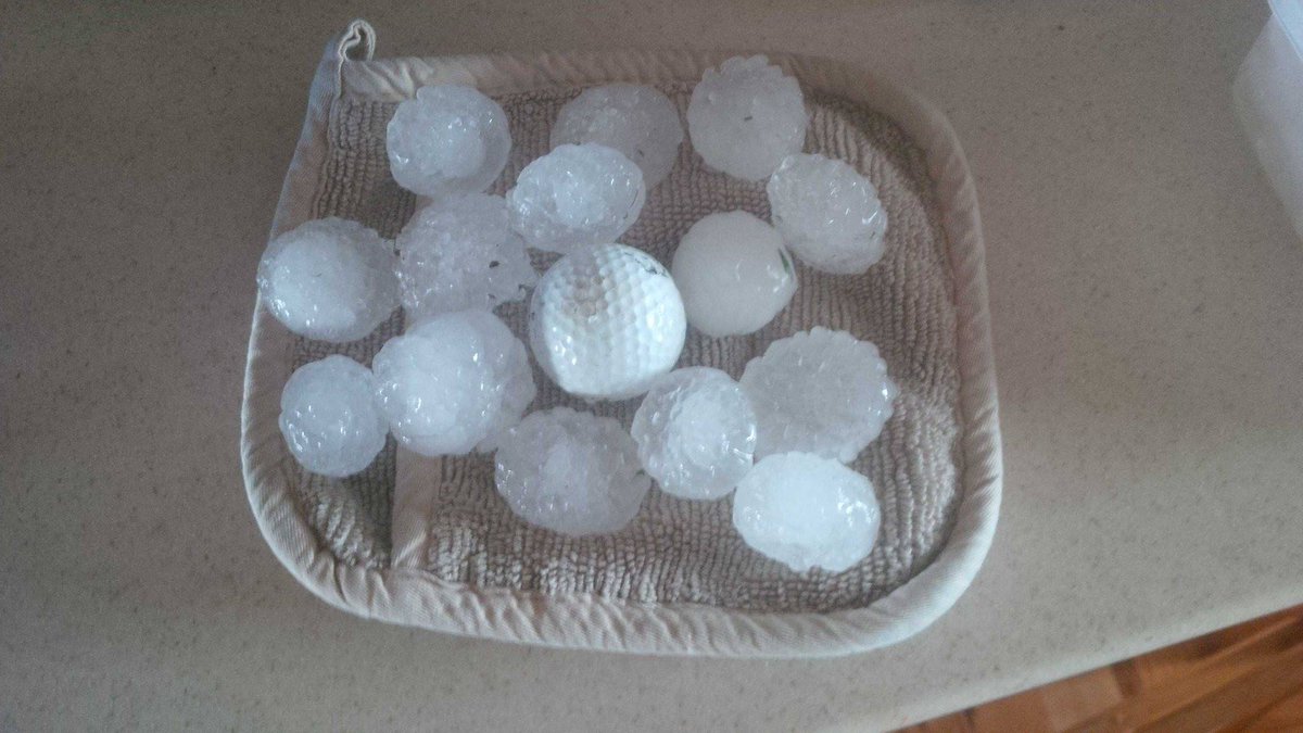
twitter:weatherchannel twitterde op dinsdag 24-03-2015 om 23:48:25 3D radar shows big #Hail building in these 2 storms just SW of #Springfield MO #mowx #severe http://t.co/hvTucqlTia reageer retweet
 3D radar shows big
twitter:TWCBreaking twitterde op woensdag 25-03-2015 om 00:55:59 Tornado Warning for Boone and Marion Counties in AR until 7:30 PM CDT http://t.co/ruJjPGx9Ua reageer retweet
 Tornado Warning for Boone and Marion Counties in AR until 7:30 PM CDT
[ Bericht 5% gewijzigd door Houtenbeen op 25-03-2015 01:03:26 ]
Bronquote:Another disturbance will move into the Plains on Wednesday bringing the risk for large hail, damaging winds and isolated tornadoes.
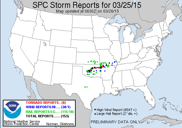
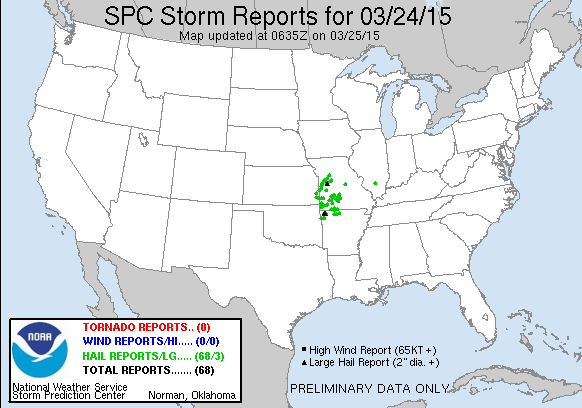
The first severe thunderstorm watch of 2015 was issued over parts of four states as the first threat of organized springtime severe weather targeted the nation's midsection on Tuesday. There were more than 60 reports of hail between 1 and 2 inches in diameter on Tuesday night.
In what has been a very quiet year for severe weather, NOAA's Storm Prediction Center had issued only four watches this year before Tuesday's watch. All of those were tornado watches – three in January and one in February.
Wednesday: Scattered severe thunderstorms should again break out by mid-late afternoon, this time near the intersection of a bulge in a surface dryline and cold front in Oklahoma, north Texas and southeast Kansas. During the evening, this activity is expected to form a squall line and push across central and southern Missouri and at least northern Arkansas. Damaging winds and large hail will again be the primary threats, but a tornado cannot be ruled out.
Kan nog steeds vandaag

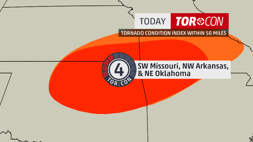
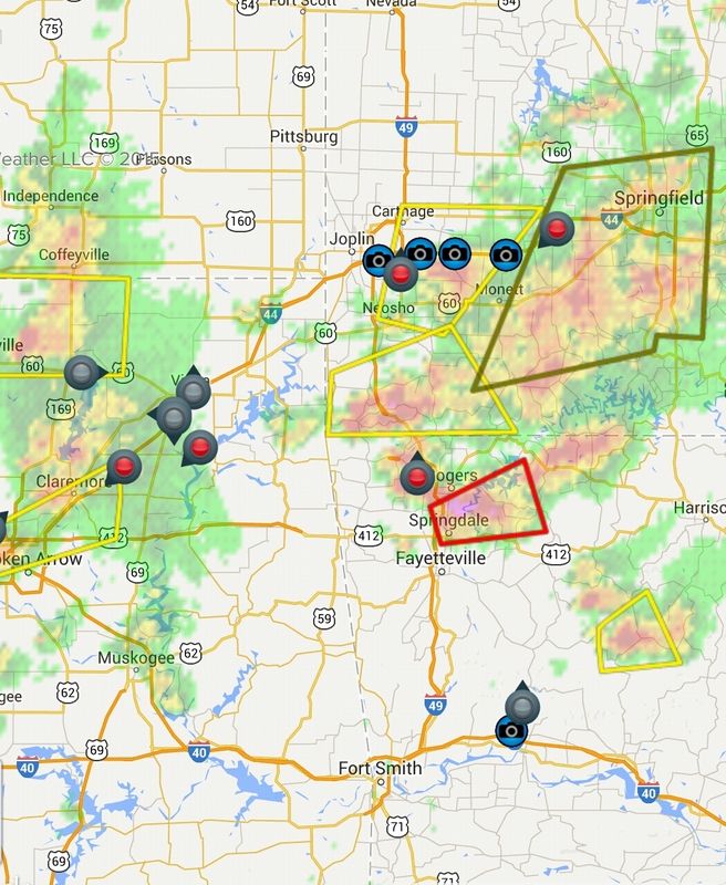
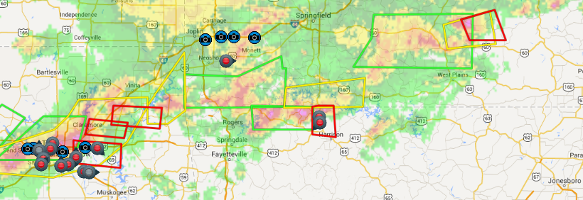
twitter:weatherchannel twitterde op woensdag 25-03-2015 om 12:46:55 #TorCon of 4 today for SW #Missouri, NW #Arkansas & NE #Oklahoma. Latest forecast: http://t.co/RgUUdZYVO7 #tornado http://t.co/ObPzNkMzIA reageer retweet


moderate risk idd. Kan laat worden vanavond.quote:
Nieuwe update: Kans wordt ineens een stuk groter
[ afbeelding ]
Tis voornamelijk voor grote hagel, maar een isolated tornado event is mogelijkquote:Op woensdag 25 maart 2015 15:01 schreef aloa het volgende:
[..]
moderate risk idd. Kan laat worden vanavond.
twitter:NWStulsa twitterde op woensdag 25-03-2015 om 17:11:29 We have upped our SVR and TOR probs based on latest data. Expect storms to develop in NE OK 3-4 PM. #okwx #arwx http://t.co/zfLjV4uR4k reageer retweet
 We have upped our SVR and TOR probs based on latest data. Expect storms to develop in NE OK 3-4 PM.
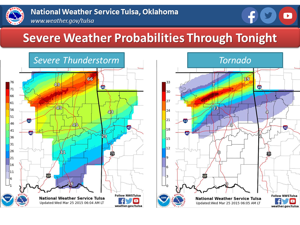
Eerste hagel wordt ook gemeld nu net boven het gebied met moderate risk. Daar ontstaan al zware onweersbuien.
[ Bericht 20% gewijzigd door #ANONIEM op 25-03-2015 18:49:15 ]
[ Bericht 20% gewijzigd door #ANONIEM op 25-03-2015 18:49:15 ]
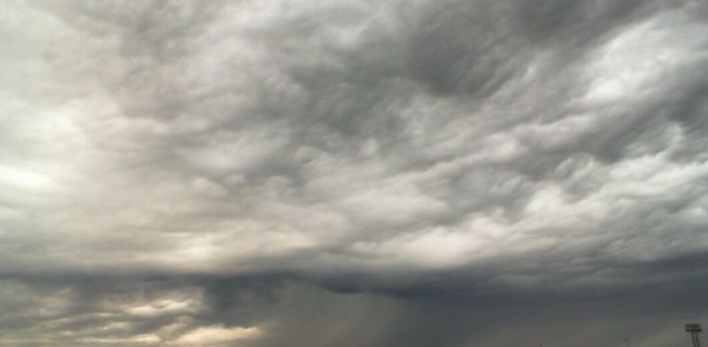
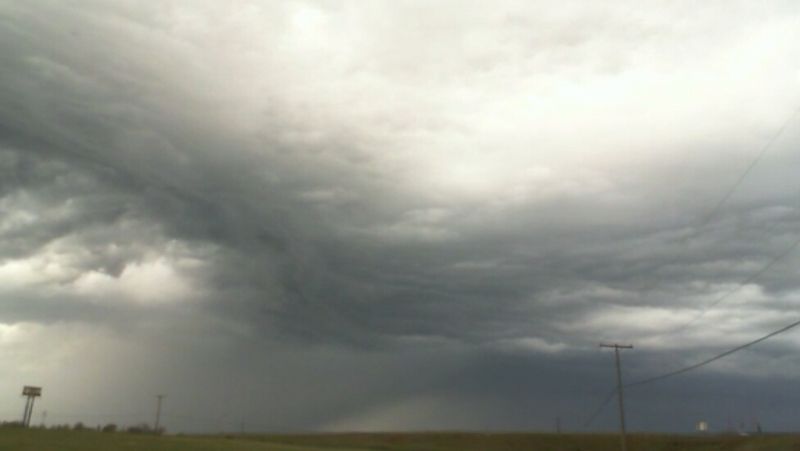
Schitterende buien momenteel.quote:
zit al een chaser bij joplin te streamen
twitter:TWCBreaking twitterde op woensdag 25-03-2015 om 22:51:17 Tornado Warning for Benton, Carroll, Madison and Washington Counties in AR until 5:15 PM CDT http://t.co/wcWobL4yeV reageer retweet
twitter:TWCBreaking twitterde op woensdag 25-03-2015 om 23:13:45 Tornado Warning for Creek, Osage, Pawnee and Tulsa Counties in OK until 5:45 PM CDT http://t.co/SJIMFIGLJv reageer retweet

twitter:weatherchannel twitterde op woensdag 25-03-2015 om 23:26:39 #BREAKING: Spotters confirm large tornado at 5:21p near Westport, Okla. moving E toward city of Tulsa. Take cover!! http://t.co/oOaDD3xuAG reageer retweet


Dat stadje word wel erg vaak belaagd door tornado's, vorg jaar ook al.quote:
http://kfor.com/on-air/live-streaming/
Tornado in Moore
🐱
twitter:abcnewswx twitterde op donderdag 26-03-2015 om 02:04:17 JUST IN: Tulsa Co. Sheriff's Office: 1 dead, others injured after tornado-warned storm moves through Sand Springs, Oklahoma. reageer retweet
 JUST IN: Tulsa Co. Sheriff's Office: 1 dead, others injured after tornado-warned storm moves through Sand Springs, Oklahoma.
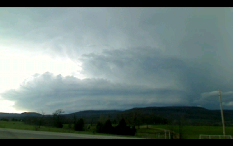
Foto van de tornado in post 141
[ Bericht 5% gewijzigd door Houtenbeen op 26-03-2015 02:43:37 ]
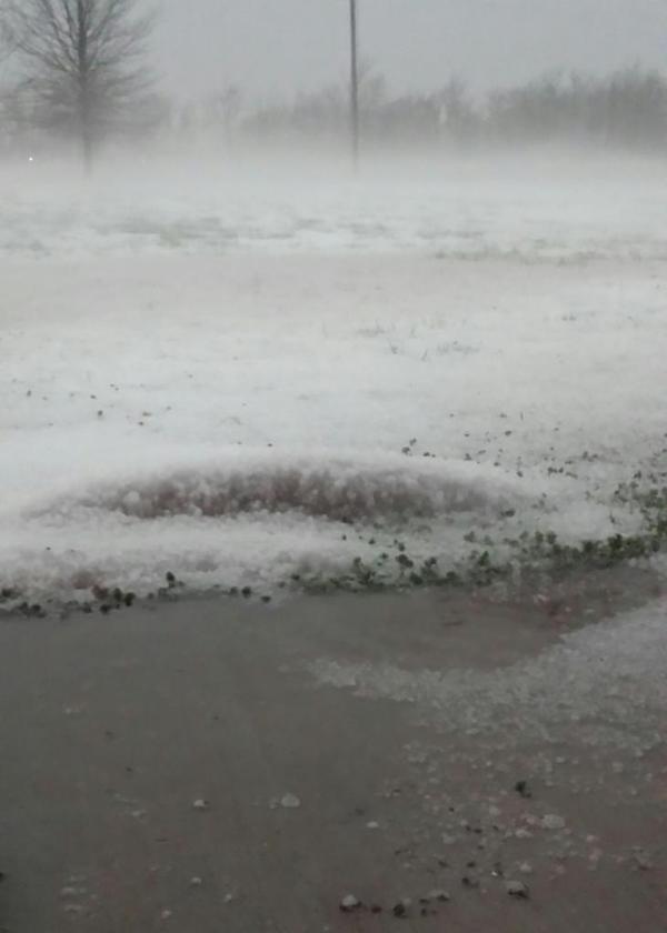
twitter:weatherchannel twitterde op donderdag 26-03-2015 om 03:06:56 Earlier this evening in Catoosa, OK. That is #hail, not snow. MT @kylievalene @weatherchannel This is our backyard! http://t.co/KD9dCswVEf reageer retweet