WKN Weer, Klimaat en Natuurrampen
Lees alles over het onstuimige weer op onze planeet, volg orkanen en tornado's, zie hoe vulkanen uitbarsten en hoe Moeder Aarde beeft bij een aardbeving. Alles over de verwoestende kracht van onze planeet en tal van andere natuurverschijnselen.


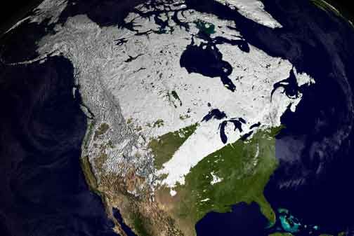
Winter in noord Amerika
Halverwege september begint de kou op het noordelijk halfrond zich weer langzaam uit te breiden richting het zuiden. In het hoge noorden van Canada zakt de temperatuur alweer onder het vriespunt en valt alweer de eerste sneeuw. De bedoeling van dit topic is om het nieuws rond de winter in noord Amerika te volgen. Nieuws, foto's, video's etc etc zijn hier welkom.
Winter in Canada
In de winter is het koud in het noorden en het midden. Temperaturen dalen daar gemakkelijk tot -30 graden. Op 1 februari werd in Snag de allerlaagste Canadese temperatuur bereikt van -62.8 graden. Alleen het uiterste westen heeft een mild klimaat. In Vancouver komt het minste vorst voor.
Noord Canada
Zuid Canada
Oost Canada
De noordoostelijke staten van de USA
De winter in New England staat bekend als een koude winter. De wind is in het winterhalfjaar noordwestelijk en droge arctische lucht uit Canada stroomt ver naar het zuiden. Deze kou-invallen gaan soms gepaard met blizzards. Opdringende warme lucht uit het zuiden zorgt af en toe voor flinke ijzel.
Gemiddeld vriest het bij de Canadese grens in januari zo'n -13 graden. In New Jersey vriest het zo'n 5 graden. In het noordoostelijke puntje van New England daalt in januari de thermometer gemiddeld elke nacht tot -19 graden. De extremen in het gebied liegen er ook niet om. Op 19 januari werd het in Van Buren (Maine) -44,4 graden. Old Forge (New York) mat op 18 februari 1979 zelfs een minimum van -46,7 graden. Het zeewater daalt in januari en februari tot +4 graden in zowel Boston als in New York.
De zuidoostelijke staten van de USA
In de winter komt de gemiddelde kou tot Atlanta. In Maryland, Virginia, de Appalachen en de hoger gelegen staten als Kentucky vriest het veelvuldig. De ergste kou vinden we nog noordelijker in Michigan en Ontario. In West Virginia vinden we de allerlaagste temperatuur van het gebied terug. Op 30 december 1917 daalde in Lewisburg de thermometer tot -38,3 graden.
Het gebied langs de Golf van Mexico beleeft een relatief milde en korte winter. Toch kan het hier soms flink vriezen. Neem bijvoorbeeld de -28 graden die in Corinth (Mississippi) op 30 januari 1966 werd gemeten. In Florida neemt de invloed van de oceaan toe. Dit is vooral merkbaar aan de gemiddelde nachttemperatuur in het zuiden. In zeer uitzonderlijke situatie vriest het hier of valt er sneeuw. Op de Key's komt de temperatuur nooit onder nul. De allerlaagste temperatuur in Florida bedroeg -18,9 graden en werd gemeten in Tallahassee.
De staten Virginia, West Virginia en Maryland krijgen in de winter soms te maken met sneeuwstormen. Deze staan bekend als Nor'easters en komen oktober en april. Ze zijn berucht om de grote hoeveelheid sneeuw, regen en de flinke wind.
Een Nor'easter komt voor als een lagedrukgebied warme vochtige subtropische lucht uit de Golf van Mexico naar het noorden voert. De lucht wordt vermengd met vochtige lucht uit de Atlantische Oceaan. Een hogedrukgebied boven Canada biedt tegenwicht en stuwt arctische lucht naar het zuiden. Daar waar de luchtsoorten bij elkaar komen, ontstaat hevige neerslag.
De meest actieve Nor'easter is de sneeuwstorm die naar het oosten trekt en de straalstroom volgt. Vooral Washington DC, Philadelphia, New York City en Boston worden dan getroffen en krijgen grote hoeveelheden regen en sneeuw te verwerken.
Het midden van de Verenigde Staten
De winters in het noorden zijn streng. Bismarck in North Dakota heeft in januari een gemiddelde temperatuur van -12,7 graden. International Falls op de grens van Canada en Minnesota heeft zelfs een gemiddelde januari-temperatuur van -17,2 graden. De nachtelijke temperaturen bedragen hier gemiddeld -23,3 graden en de dagtemperatuur -11,2 graden.
De staten langs de Canadese grens en de Grote Meren krijgen ook in de winter vaak te maken met 'blizzards', die zeer koude lucht aanvoeren vanuit het arctische Canada. Het gebied is dan bedekt met een sneeuwlaag. Veel is dit niet. In januari valt er slechts enkele tientallen millimeters neerslag.
Veel nachten verlopen helder en de aanwezigheid van een sneeuwdek helpt mee aan een lage temperatuur. De allerlaagste temperatuur in North Dakota werd gemeten op 15 februari 1936. In Parshall werd het -51,1 graden. Op 2 februari 1996 gebeurde hetzelfde in Towar, Minnesota.
Naar het zuiden neemt de strengheid van de winter af. Tot in Kansas is de gemiddelde januaritemperatuur onder nul. In Texas loopt deze snel op. Niet alleen de zuidelijke ligging, maar ook de aanwezigheid van de Golf van Mexico speelt daarbij een rol. In Brownsville op de grens met Mexico is het in januari overdag 20,5 graden en incidenteel boven de 33 graden.
Toch krijgen relatief zuidelijk gelegen gebieden 's winters soms te maken met extreme koude situaties, doordat luchtstromen uit het hoge noorden van Canada hun weg zuidwaarts zoeken tussen de Rocky Mountains en de Appalachen. Zo was het in het ogenschijnlijk warme Texas op 3 februari 1933 in Seminole -30,6 graden.
Westen van de Verenigde Staten
In de winter heerst de meeste kou in de hoger gelegen delen van de Rocky Mountains. Arctische lucht uit Canada zorgt voor strenge winters in het noorden, zoals in Montana, Wyoming en Colorado. In Montana richt de snijdend koude wind geregeld slachtingen aan onder de veestapel. De allerlaagste temperatuur in Montana werd gemeten op 20 januari 1954. Op Rogers Pass werd het toen -56,7 graden onder nul.
In Wyoming waar ook lange strenge winters voorkomen, staat het minimumrecord op bijna -53 graden vorst. Het berggebied van Idao, Utah en Colorado is koud en sneeuwachtig. Vooral in Colorado valt veel sneeuw. Temperaturen tot onder de -50 graden zijn incidenteel mogelijk. De hoogvlakte van Nevada is eveneens koud. In Ely op 1900 meter hoogte vriest het in januari 's nachts zo'n -12,5 graden. Dit wordt tevens veroorzaakt door de vele heldere nachten in het gebied.
Warmer is het in Washington en Oregon. Het kan hier behoorlijk vriezen, maar aan zee is de winter relatief mild. De regen valt vooral tussen oktober en april. In de bergen gaat het dan om sneeuw en worden wegen afgesloten.
In het zuidwesten van Californië blijft het winters klimaat aangenaam en vriest het zelden. Het is daar dan ook regentijd. Toch kan de winter flink uithalen. Vooral in de Sierra Nevada is dat het geval. De allerlaagste temperatuur in Californië die is gemeten bedraagt -42,8 graden. In New Mexico tenslotte zijn de winters koel maar niet extreem koud.
Alaska
In de noordelijke Amerikaanse staat Alaska heersen verschillende klimaten. Zeestromingen, bergruggen en een lage zonnestand bepalen voornamelijk het klimaat. In het noorden komen poolwoestijnen voor, in het zuiden heerst een mild klimaat dat vergelijkbaar is met Nederland.
Bron:
Stormnamen
Sinds dit jaar gaan de Amerikanen de zwaardere winterstormen ook namen geven net zoals ze doen bij de orkanen en tropische stormen in de Atlantische en Pacifische oceaan.
Voor dit jaar zijn de namen:
Athena - Brutus - Caesar - Draco - Euclid - Freyr - Gandolf - Helen - Iago - Jove - Kahn - Luna - Magnus - Nemo - Orko - Plato - Q - Rocky - Saturn - Triton - Ukko - Virgil - Walda - Xerxes - Yogi - Zeus
De bedoeling van dit Topic is om het winterweer in Noord Amerika te volgen.
B.v. via onderstaande site's
Weather Channel
Accuweather
Winter Weather cnn
Google News
US wind kaart
Great Lakes map
vorige delen:
Topicreeks: Winter in Noord Amerika
verwante topics
Hurricane Season 2012 # 1
Wintervoorspelling 2012/2013
Poolkappen, IJsbergen en Gletsjers #4
Weeralarm VS #15 Tornado's, Hitte en Droogte
De huidige temperaturen in Canada
De huidige temperaturen in de V.S.
De huidige temperaturen in Alaska
Kaartje waarop de sneeuwhoogte en uitbreiding van het noordpoolijs is te volgen.
[ Bericht 0% gewijzigd door Frutsel op 09-10-2012 12:11:07 ]
Halverwege september begint de kou op het noordelijk halfrond zich weer langzaam uit te breiden richting het zuiden. In het hoge noorden van Canada zakt de temperatuur alweer onder het vriespunt en valt alweer de eerste sneeuw. De bedoeling van dit topic is om het nieuws rond de winter in noord Amerika te volgen. Nieuws, foto's, video's etc etc zijn hier welkom.
Winter in Canada
In de winter is het koud in het noorden en het midden. Temperaturen dalen daar gemakkelijk tot -30 graden. Op 1 februari werd in Snag de allerlaagste Canadese temperatuur bereikt van -62.8 graden. Alleen het uiterste westen heeft een mild klimaat. In Vancouver komt het minste vorst voor.
Noord Canada
Zuid Canada
Oost Canada
De noordoostelijke staten van de USA
De winter in New England staat bekend als een koude winter. De wind is in het winterhalfjaar noordwestelijk en droge arctische lucht uit Canada stroomt ver naar het zuiden. Deze kou-invallen gaan soms gepaard met blizzards. Opdringende warme lucht uit het zuiden zorgt af en toe voor flinke ijzel.
Gemiddeld vriest het bij de Canadese grens in januari zo'n -13 graden. In New Jersey vriest het zo'n 5 graden. In het noordoostelijke puntje van New England daalt in januari de thermometer gemiddeld elke nacht tot -19 graden. De extremen in het gebied liegen er ook niet om. Op 19 januari werd het in Van Buren (Maine) -44,4 graden. Old Forge (New York) mat op 18 februari 1979 zelfs een minimum van -46,7 graden. Het zeewater daalt in januari en februari tot +4 graden in zowel Boston als in New York.
De zuidoostelijke staten van de USA
In de winter komt de gemiddelde kou tot Atlanta. In Maryland, Virginia, de Appalachen en de hoger gelegen staten als Kentucky vriest het veelvuldig. De ergste kou vinden we nog noordelijker in Michigan en Ontario. In West Virginia vinden we de allerlaagste temperatuur van het gebied terug. Op 30 december 1917 daalde in Lewisburg de thermometer tot -38,3 graden.
Het gebied langs de Golf van Mexico beleeft een relatief milde en korte winter. Toch kan het hier soms flink vriezen. Neem bijvoorbeeld de -28 graden die in Corinth (Mississippi) op 30 januari 1966 werd gemeten. In Florida neemt de invloed van de oceaan toe. Dit is vooral merkbaar aan de gemiddelde nachttemperatuur in het zuiden. In zeer uitzonderlijke situatie vriest het hier of valt er sneeuw. Op de Key's komt de temperatuur nooit onder nul. De allerlaagste temperatuur in Florida bedroeg -18,9 graden en werd gemeten in Tallahassee.
De staten Virginia, West Virginia en Maryland krijgen in de winter soms te maken met sneeuwstormen. Deze staan bekend als Nor'easters en komen oktober en april. Ze zijn berucht om de grote hoeveelheid sneeuw, regen en de flinke wind.
Een Nor'easter komt voor als een lagedrukgebied warme vochtige subtropische lucht uit de Golf van Mexico naar het noorden voert. De lucht wordt vermengd met vochtige lucht uit de Atlantische Oceaan. Een hogedrukgebied boven Canada biedt tegenwicht en stuwt arctische lucht naar het zuiden. Daar waar de luchtsoorten bij elkaar komen, ontstaat hevige neerslag.
De meest actieve Nor'easter is de sneeuwstorm die naar het oosten trekt en de straalstroom volgt. Vooral Washington DC, Philadelphia, New York City en Boston worden dan getroffen en krijgen grote hoeveelheden regen en sneeuw te verwerken.
Het midden van de Verenigde Staten
De winters in het noorden zijn streng. Bismarck in North Dakota heeft in januari een gemiddelde temperatuur van -12,7 graden. International Falls op de grens van Canada en Minnesota heeft zelfs een gemiddelde januari-temperatuur van -17,2 graden. De nachtelijke temperaturen bedragen hier gemiddeld -23,3 graden en de dagtemperatuur -11,2 graden.
De staten langs de Canadese grens en de Grote Meren krijgen ook in de winter vaak te maken met 'blizzards', die zeer koude lucht aanvoeren vanuit het arctische Canada. Het gebied is dan bedekt met een sneeuwlaag. Veel is dit niet. In januari valt er slechts enkele tientallen millimeters neerslag.
Veel nachten verlopen helder en de aanwezigheid van een sneeuwdek helpt mee aan een lage temperatuur. De allerlaagste temperatuur in North Dakota werd gemeten op 15 februari 1936. In Parshall werd het -51,1 graden. Op 2 februari 1996 gebeurde hetzelfde in Towar, Minnesota.
Naar het zuiden neemt de strengheid van de winter af. Tot in Kansas is de gemiddelde januaritemperatuur onder nul. In Texas loopt deze snel op. Niet alleen de zuidelijke ligging, maar ook de aanwezigheid van de Golf van Mexico speelt daarbij een rol. In Brownsville op de grens met Mexico is het in januari overdag 20,5 graden en incidenteel boven de 33 graden.
Toch krijgen relatief zuidelijk gelegen gebieden 's winters soms te maken met extreme koude situaties, doordat luchtstromen uit het hoge noorden van Canada hun weg zuidwaarts zoeken tussen de Rocky Mountains en de Appalachen. Zo was het in het ogenschijnlijk warme Texas op 3 februari 1933 in Seminole -30,6 graden.

Westen van de Verenigde Staten
In de winter heerst de meeste kou in de hoger gelegen delen van de Rocky Mountains. Arctische lucht uit Canada zorgt voor strenge winters in het noorden, zoals in Montana, Wyoming en Colorado. In Montana richt de snijdend koude wind geregeld slachtingen aan onder de veestapel. De allerlaagste temperatuur in Montana werd gemeten op 20 januari 1954. Op Rogers Pass werd het toen -56,7 graden onder nul.
In Wyoming waar ook lange strenge winters voorkomen, staat het minimumrecord op bijna -53 graden vorst. Het berggebied van Idao, Utah en Colorado is koud en sneeuwachtig. Vooral in Colorado valt veel sneeuw. Temperaturen tot onder de -50 graden zijn incidenteel mogelijk. De hoogvlakte van Nevada is eveneens koud. In Ely op 1900 meter hoogte vriest het in januari 's nachts zo'n -12,5 graden. Dit wordt tevens veroorzaakt door de vele heldere nachten in het gebied.
Warmer is het in Washington en Oregon. Het kan hier behoorlijk vriezen, maar aan zee is de winter relatief mild. De regen valt vooral tussen oktober en april. In de bergen gaat het dan om sneeuw en worden wegen afgesloten.
In het zuidwesten van Californië blijft het winters klimaat aangenaam en vriest het zelden. Het is daar dan ook regentijd. Toch kan de winter flink uithalen. Vooral in de Sierra Nevada is dat het geval. De allerlaagste temperatuur in Californië die is gemeten bedraagt -42,8 graden. In New Mexico tenslotte zijn de winters koel maar niet extreem koud.

Alaska
In de noordelijke Amerikaanse staat Alaska heersen verschillende klimaten. Zeestromingen, bergruggen en een lage zonnestand bepalen voornamelijk het klimaat. In het noorden komen poolwoestijnen voor, in het zuiden heerst een mild klimaat dat vergelijkbaar is met Nederland.
Bron:
Stormnamen
Sinds dit jaar gaan de Amerikanen de zwaardere winterstormen ook namen geven net zoals ze doen bij de orkanen en tropische stormen in de Atlantische en Pacifische oceaan.
Voor dit jaar zijn de namen:
Athena - Brutus - Caesar - Draco - Euclid - Freyr - Gandolf - Helen - Iago - Jove - Kahn - Luna - Magnus - Nemo - Orko - Plato - Q - Rocky - Saturn - Triton - Ukko - Virgil - Walda - Xerxes - Yogi - Zeus
De bedoeling van dit Topic is om het winterweer in Noord Amerika te volgen.
B.v. via onderstaande site's
Weather Channel
Accuweather
Winter Weather cnn
Google News
US wind kaart
Great Lakes map
vorige delen:
Topicreeks: Winter in Noord Amerika
verwante topics
Hurricane Season 2012 # 1
Wintervoorspelling 2012/2013
Poolkappen, IJsbergen en Gletsjers #4
Weeralarm VS #15 Tornado's, Hitte en Droogte


De huidige temperaturen in Canada

De huidige temperaturen in de V.S.

De huidige temperaturen in Alaska

Kaartje waarop de sneeuwhoogte en uitbreiding van het noordpoolijs is te volgen.

[ Bericht 0% gewijzigd door Frutsel op 09-10-2012 12:11:07 ]


Toch grappig dat het zuiden van Alaska een vergelijkbaar klimaat heeft als Nederland, zo zonder erbij na te denken denk je bij Alaska aan kou 
Klonk is alleen Klonk als er Klonk op staat
Het jaargemiddelde is wel een stuk lager. In het zuiden van Alaska 4 graden (zuidoosten 7 graden)...in Nederland is dat meer dan 10 graden.quote:Op zondag 7 oktober 2012 19:21 schreef Klonk het volgende:
Toch grappig dat het zuiden van Alaska een vergelijkbaar klimaat heeft als Nederland, zo zonder erbij na te denken denk je bij Alaska aan kou
[ Bericht 1% gewijzigd door #ANONIEM op 07-10-2012 20:09:01 ]
In het noorden van Alaska is de gemiddelde jaartemperatuur -12 graden. 322 dagen per jaar komt het daar onder nul. 
Ik heb nog een paar aardige links voor de VS:
Wind map: http://hint.fm/wind/index.html
Great Lakes map: http://www.glerl.noaa.gov(...)fs-currents-avg.html
Wind map: http://hint.fm/wind/index.html
Great Lakes map: http://www.glerl.noaa.gov(...)fs-currents-avg.html
You must be out of your brilliant mind.

NOAA's wintervoorspelling
http://www.noaanews.noaa.(...)8_winteroutlook.htmlquote:Elusive El Niño challenges NOAA’s 2012 U.S. Winter Outlook
October 18, 2012
The western half of the continental U.S. and central and northern Alaska could be in for a warmer-than-average winter, while most of Florida might be colder-than-normal December through February, according to NOAA’s annual Winter Outlook announced today from the agency’s new Center for Weather and Climate Prediction in College Park, Md.
Forecasters with NOAA’s Climate Prediction Center say a wavering El Niño, expected to have developed by now, makes this year’s winter outlook less certain than previous years.
“This is one of the most challenging outlooks we’ve produced in recent years because El Niño decided not to show up as expected,” said Mike Halpert, deputy director of NOAA’s Climate Prediction Center. “In fact, it stalled out last month, leaving neutral conditions in place in the tropical Pacific.”
When El Niño is present, warmer ocean water in the equatorial Pacific shifts the patterns of tropical rainfall that in turn influence the strength and position of the jetstream and storms over the Pacific Ocean and United States. This climate pattern gives seasonal forecasters confidence in how the U.S. winter will unfold. An El Niño watch remains in effect because there’s still a window for it to emerge.
Other climate factors can influence winter weather across the country. Some of these factors, such as the North Atlantic Oscillation, a prominent climate pattern, are difficult to predict more than one to two weeks in advance. The NAO adds uncertainty to the winter outlook in the Northeast and Mid-Atlantic portions of the country.
Areas ravaged by extreme drought over the past year are unlikely to see much relief from drought conditions this winter.
Warmer-than-average temperatures in much of Texas, northward through the Central and Northern Plains and westward across the Southwest, the Northern Rockies, and eastern Washington, Oregon and California, as well as the northern two-thirds of Alaska.
Cooler-than-average temperatures in Hawaii and in most of Florida, excluding the panhandle.
Drier-than-average conditions in Hawaii, the Pacific Northwest and Northern California, including Idaho, western Montana, and portions of Wyoming, Utah and most of Nevada.
Drier-than-average conditions in the upper Midwest, including Minnesota, Wisconsin, Iowa and northern Missouri and eastern parts of North and South Dakota, Nebraska, Kansas, and western Illinois.
Wetter-than-average conditions across the Gulf Coast states from the northern half of Florida to eastern Texas.
The rest of the country falls into the “equal chance” category, meaning these areas have an equal chance for above-, near-, or below-normal temperatures and/or precipitation.
This seasonal outlook does not project where and when snowstorms may hit or provide total seasonal snowfall accumulations. Snow forecasts are dependent upon the strength and track of winter storms, which are generally not predictable more than a week in advance.
NOAA's National Weather Service is the primary source of weather data, forecasts and warnings for the United States and its territories. NOAA’s National Weather Service operates the most advanced weather and flood warning and forecast system in the world, helping to protect lives and property and enhance the national economy. Working with partners, NOAA’s National Weather Service is building a Weather-Ready Nation to support community resilience in the face of increasing vulnerability to extreme weather. Visit us online at weather.gov and on Facebook.
NOAA’s mission is to understand and predict changes in the Earth's environment, from the depths of the ocean to the surface of the sun, and to conserve and manage our coastal and marine resources. Visit us at www.noaa.gov and join us on Facebook, Twitter and our other social media channels.
Ik verwacht een milde winter met minima rond het vriespunt. Groetjes uit Houston TX.
Jesus saves but death prevails.
quote:Nieuwe storm op weg naar de VS
Een nieuwe storm die richting de oostkust van de Verenigde Staten trekt kan tot evacuaties leiden. Dat liet de gouverneur van de staat New York, Andrew Cuomo, weten. "Mocht het noodzakelijk zijn te evacueren, dan beginnen we daar vroeg mee'', voegde Cuomo daaraan toe.
"Normaal gesproken is de nieuwe storm niet levensbedreigend, maar we verkeren niet in een normale situatie", aldus de gouverneur. Hij waarschuwt dat de storm het puin van superstorm Sandy in de lucht kan zuigen en met hoge snelheden rond kan slingeren, met alle gevolgen van dien.
Volgens meteorologen kan de nieuwe storm woensdag (plaatselijke tijd) aan land komen bij de staten New York en New Jersey.
ik zag het net op RTL. Toch wel triest voor de bewoners daarquote:
“Loop niet voor me, want ik volg niet.
Loop niet achter me, want ik leid niet.
Loop gewoon naast me en wees mijn vriend.”
Loop niet achter me, want ik leid niet.
Loop gewoon naast me en wees mijn vriend.”
quote:Nieuwe storm VS zwakker dan verwacht
Een nieuwe atlantische storm die het opruimwerk na de orkaan Sandy kon bedreigen, blijft verder uit de Amerikaanse oostkust dan verwacht. Dit betekent minder wind en regen op het land, zegt Jeff Masters van Weather Underground.
Wel moet woensdagmiddag en -avond in New York en New Jersey rekening worden gehouden met windstoten tot tachtig kilometer per uur. Ook wordt bij vloed een hogere waterstand verwacht dan normaal.
Liveupdatesquote:Northeaster hammers Northeast
Rain, strong winds and snow will continue to overspread more of the Northeast through tonight as a potent nor'easter churns offshore.
Gusty winds along the Northeast coast not only threaten to cause more damage in areas ravaged by Sandy last week, but also could drive ocean water into coastal communities that are no longer being protected by dunes.
Rain is adding to the misery of the day along the coastline, while places along and just west of Interstate 95 will be shoveling snow before the start of Thursday.
To read more about how the nor'easter will impact the Northeast through Thursday, please read this news story or track the storm with the following updates from AccuWeather.com.
You can also jump below for a list of stories that give more precise details of how the nor'easter will impact specific cities and communities.

'Athena' teistert noordoosten van de VS
NEW YORK - Het noordoosten van de Verenigde Staten kampt opnieuw met noodweer. Een storm brengt vanuit het noordoosten kou en sneeuw naar de streek waar nog steeds mensen zonder stroom zitten als gevolg van de verwoestende wervelstorm Sandy van afgelopen week. In de staten New Jersey, New York en Connecticut is op verscheidene plekken de stroom weer uitgevallen. Op een aantal plaatsen langs kust van New Jersey en Long Island (New York) zijn evacuaties bevolen.
Hoewel deze storm minder zwaar is dan Sandy, zorgt ze voor grote problemen door harde wind, regen en sneeuwval. Het verkeer in grote delen van de stad New York werd woensdagavond door sneeuwval ontregeld. De Amerikaanse meteorologische dienst wil niet dat deze storm te veel aan Sandy herinnert. De dienst heeft daarom donderdag nadrukkelijk gezegd dat het stormachtige herfstweer geen naam heeft.
Yards of Snow for Northern Sierra High Country
http://www.accuweather.co(...)northern-sie/2131690quote:A series of storms into early next week will bring tremendous high country snow and the risk of avalanches to the West.
Yards of snow will fall on the northern Sierra Nevada, and feet of snow will accumulate in the Cascades.
Snow levels will vary during the siege of storms and will dip to pass levels at times, especially over the northern Cascades.
At elevations above 7,500 feet in the northern Sierra Nevada, the storms are likely to bring between 6 and 10 feet of snow with blizzard conditions at times due to winds topping 100 mph. Similar conditions are in store for Mount Shasta.
High winds, even below snow levels, could cause some high-profile vehicles to roll over.
Conditions may get much worse than this over some of the passes in the Cascades this weekend.
Through the weekend and into early next week, from 2 to 4 feet of snow is forecast to fall over the high country in the Cascades of Washington and Oregon, as well as the Bitterroots of Idaho and Montana.
Wintry Travel
For a brief time, snow will fall down to the high spots on I-80 at Donner Pass, where a half a foot to a foot of wet snow can fall through Friday. Over the weekend, snow levels will rise above pass level in the northern Sierra Nevada.
Farther north, rounds of snow will end up being more of a problem for travelers.
Initially, through Friday, accumulating snow will be above most passes in the Cascades of Washington and Oregon. Snow levels during this period will generally be above 4,000 feet. A mixture of rain and snow can occur over I-90 through Snoqualmie Pass through Friday.
However, over the weekend, snow levels will lower as the air turns a bit colder. This will bring accumulating snow to many passes Sunday into next week. By Monday, snow levels may lower to near 2,500 feet.
The storms and their snow through much of next week will avoid the Arizona Rim Country, the Wasatch and central and southern Rockies.
in the northern Sierra Nevada, snow levels will rise significantly Sunday, before falling back early next week. That could bring a rapid meltdown of the snow at rather high elevations for a time and add to the risk of flooding and other problems.
Avalanche Danger
The series of storms with their high country snow will raise the risk of avalanches.
Feet and yards of snow accumulating in rapid fashion, combined with locally high winds and fluctuating temperatures, will make the slopes very unstable.
While avalanches are more common in the late winter and spring, they can occur in situations like this during the late autumn and early winter.
There is a possibility of significant snow slides especially over the weekend into next week.
By then the weight of the snow will be tremendous and any surge of warmth next week can cause the snow on the slopes to give way.
Vooruitzicht 7 dagen voor Mount Chasta. Daar gaat gigantisch veel sneeuw vallen. Een aantal dagen is meer dan een meter voorspeld.

Sneeuwstorm voor het noorden van de VS.
quote:A potent winter storm will impact the region for the rest of this weekend. Moderate to heavy snow is expected tonight across eastern South Dakota and western Minnesota. This will be followed by lighter snow, but increasing northwest winds by early Sunday morning. With the increasing northwest winds, wide-side blizzard conditions are expected for locations along the North Dakota, South Dakota border.
In Minneapolis verwarmen ze het Metrodome om te voorkomen dat het dak weer instort door de hevige sneeuwval. De temperatuur in het grote stadion loopt op tot bijna 27 graden.
In 2010 begaf het plafond het onder het gewicht van alle sneeuw.
bron
In 2010 begaf het plafond het onder het gewicht van alle sneeuw.

bron

Veel ongelukken door spekgladde wegen bij Oklahoma. Bij een ongeluk waren 20 auto's betrokken.
http://www.news9.com/Global/category.asp?C=202212&BannerId=715quote:OKLAHOMA CITY - The Oklahoma Highway Patrol and local police departments responded to several Christmas morning car accidents, including a major crash involving 20 vehicles on westbound Interstate 40 near Interstate 35.
Check on road conditions in Oklahoma City
Freezing rain turned highways and roads across central Oklahoma into slick messes. Around 4:30 a.m., cars began losing control on a westbound I-40 overpass at I-35. The weather created black ice on the overpass and drivers were taken by surprise.
Three semi trucks and 17 cars crashed into each other. State troopers shut down westbound I-40, and shuttled drivers to a nearby hotel while they investigated the multi-car crash and tried to clear away the wreckage.
It's not known when the highway will reopen.
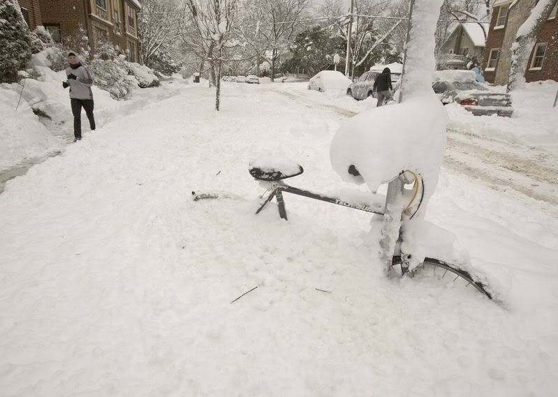
Winterse weer VS trekt richting noordoosten
(Novum/AP) - OKLAHOMA CITY - Het winterse weer dat in het midden en zuiden van de Verenigde Staten al aan zeker zes mensen het leven heeft gekost, verplaatst zich donderdag richting het noordoosten van het land. Harde wind en hevige sneeuwval zorgen voor verkeerschaos. In duizenden huishoudens is de stroom uitgevallen.
Woensdag werden meer dan zestienhonderd vluchten geannuleerd of vertraagd en kwamen tientallen automobilisten vast te zitten op de gladde, besneeuwde wegen. Voor donderdag wordt in het gebied van New York tot Maine landinwaarts dertig tot 45 centimeter sneeuw verwacht. Langs de kust is er sprake van natte sneeuw.
nieuws.nl
Opvallend koud in delen van de VS, Met waarschuwingen i.v.m. de windchill.

quote:Brrr…in de VS
“The coldest morning in a couple of years” in delen van het noordoosten van de Verenigde Staten donderdagochtend. Ook elders in de VS en Zuidoost-Canada heeft het regionaal bijzonder hard gevroren. In Massena, New York, werd het -28,3º, in Saranac Lake (eveneens New York state) -31,1º en in Alamosa in Colorado werd met -36,1º een datumrecord gebroken. Bovendien was het daar de laagste temperatuur in vijf jaar. Verder in Montreal, Quebec -23,3º. In de gehele winter van een jaar geleden (2011-2012) bedroeg de laagste waarde daar -23,9º.
Jan Visser
Halve meter sneeuw in New Foundland

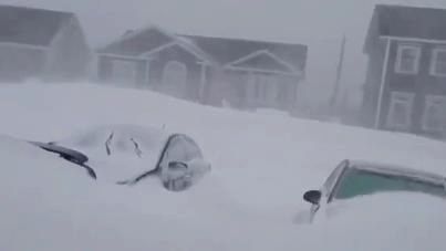

quote:ST. JOHN’S, N.L. – Plows will be clearing the streets of Newfoundland’s capital for several days after a blast of winter brought nearly 50 centimetres to the region on Friday, grounding flights and knocking out power for thousands.
Paul Mackey, the city’s director of Public Works and Parks, says roads in St. John’s were accessible by at least one lane on Saturday morning.
He says crews will be working to widen the streets for the next several days.
The St. John’s International Airport says on its website it will remain closed to air traffic until midnight Sunday, citing an “incredible amount” of heavy, wet snow.
Michele Coughlan of Newfoundland Power says about 2,700 are still in the dark on the Avalon Peninsula and in central Newfoundland, down from about 65,000 on Friday.
The city’s airport had recorded wind gusts of more than 100 kilometres an hour and 48 centimetres of snow before it changed to freezing drizzle Friday.
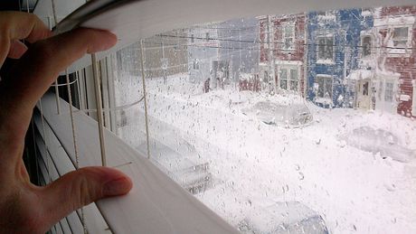
Noodweer op komst in New York: ruim tweeduizend vluchten geannuleerd
New York City maakt zich op voor een hevige sneeuwstorm van mogelijk historische omvang die richting het noord-oosten van de Verenigde Staten raast. De drie grote vliegmaatschappijen hebben voor vrijdag in totaal al 2100 vluchten geannuleerd wegens het naderende noodweer.
De weersvoorspellingen liegen er niet om. Naar verwachting zal New England, de regio in het uiterste noord-oosten van Amerika, onder een berg sneeuw van zo'n 60 centimeter terecht komen. In New York wordt meer dan 30 centimeter sneeuw verwacht.
hln
[ Bericht 9% gewijzigd door #ANONIEM op 08-02-2013 07:25:44 ]
New York City maakt zich op voor een hevige sneeuwstorm van mogelijk historische omvang die richting het noord-oosten van de Verenigde Staten raast. De drie grote vliegmaatschappijen hebben voor vrijdag in totaal al 2100 vluchten geannuleerd wegens het naderende noodweer.
De weersvoorspellingen liegen er niet om. Naar verwachting zal New England, de regio in het uiterste noord-oosten van Amerika, onder een berg sneeuw van zo'n 60 centimeter terecht komen. In New York wordt meer dan 30 centimeter sneeuw verwacht.

hln
[ Bericht 9% gewijzigd door #ANONIEM op 08-02-2013 07:25:44 ]

quote:Op vrijdag 8 februari 2013 07:23 schreef aloa het volgende:
Noodweer op komst in New York: ruim tweeduizend vluchten geannuleerd
New York City maakt zich op voor een hevige sneeuwstorm van mogelijk historische omvang die richting het noord-oosten van de Verenigde Staten raast. De drie grote vliegmaatschappijen hebben voor vrijdag in totaal al 2100 vluchten geannuleerd wegens het naderende noodweer.
De weersvoorspellingen liegen er niet om. Naar verwachting zal New England, de regio in het uiterste noord-oosten van Amerika, onder een berg sneeuw van zo'n 60 centimeter terecht komen. In New York wordt meer dan 30 centimeter sneeuw verwacht.
[ afbeelding ]
hln
Ik hoop dat het mee gaat vallen. Mijn nichtje gaat, net dit weekend, naar New York. Zal weinig shoppen worden als er zoveel sneeuw ligt. 
“Loop niet voor me, want ik volg niet.
Loop niet achter me, want ik leid niet.
Loop gewoon naast me en wees mijn vriend.”
Loop niet achter me, want ik leid niet.
Loop gewoon naast me en wees mijn vriend.”
Vanuit Europa naar New York vliegen om daar een weekendje shoppen is sowieso toppunt van decadentie en verspilling. Dit zijn nou echt een voorbeeld van dingen die totaal overbodig zijn met het oog op eindige bronnen en klimaatverandering. Vliegen is kennelijk nog steeds veel te goedkoop.
Ze verwachten tussen de 30 en 40 inch in Boston.. je zult het meemaken hé 
“Rather than love, than money, than fame, give me truth.”
Het sneeuwt inmiddels in New York. De wind gaat nog verder toenemen.quote:Op vrijdag 8 februari 2013 10:49 schreef Infection het volgende:
Hoe laat wordt deze sneeuwstorm verwacht? En is dit nog ergens live te volgen?
http://www.earthcam.com/usa/newyork/timessquare/


quote:Historische winterstorm op weg naar oostkust van de VS
Het noordoosten van de Verenigde Staten zet zich schrap voor sneeuw, veel sneeuw. Vandaag zullen twee stormfronten op elkaar botsen boven de regio met veel neerslag als gevolg. Luchtvaartmaatschappijen hebben uit voorzorg bijna 3000 vluchten geschrapt. Er zullen geen vliegtuigen van Schiphol naar New York en Boston vertrekken. Ook treinen zullen uit veiligheidsoverwegingen niet rijden, melden Amerikaanse media.
In de omgeving van Chicago is het gisterenmiddag begonnen met sneeuwen, het noordoosten van de Verenigde Staten volgde vanochtend. Volgens de huidige weersverwachting neemt de storm vannacht extreme proporties aan, met windvlagen die 105 kilometer per uur bereiken.
Michael R. Bloomberg, burgemeester van New York, noemde deze timing een geluk bij een ongeluk. 'De reinigingsdienst zal van vrijdag op zaterdagnacht de mogelijkheid hebben om de straten schoon te vegen, omdat er dan minder verkeer is dan normaal,' zei hij in de New York Times. Luchtig voegde hij daaraan toe: 'Als je van sneeuw houdt, dan is het goede nieuws dat we sneeuw zullen hebben.'
Hamsteren
De bevolking neemt ondertussen het zekere voor het onzekere en is gaan hamsteren. Veel mensen verwachten wel een aantal dagen vast te zullen zitten in hun huis. Op veel plaatsen wordt minstens een meter sneeuw verwacht. Niet alleen halen ze extra boodschappen in huis, ook doe het zelf zaken worden leeggekocht en bij benzinestations hebben zich inmiddels lange rijen gevormd.
Dierentuin
'Het lijkt hier wel een dierentuin. Er ligt niets meer in de schappen. Ik geloof dat ik elke fles water heb die ze op voorraad hadden', zegt een inwoner van Reading in de staat Massachusetts tegen zender WHDH.
Veel overheidspersoneel in de staat heeft opdracht gekregen thuis te werken. Scholen zijn gesloten. 'Wees een goede buur, neem ook een kijkje bij ouderen', riep gouverneur Deval Patrick donderdag mensen al op.
Nieuw-Engeland
Als de huidige weersverwachting aanhoudt, concurreert de storm met die in 1978 in Nieuw-Engeland. Toen viel er bijna een meter sneeeuw in Boston en de omliggende steden. De doordeweekse storm zorgde voor tiendallen doden en sloot de regio enkele dagen van de buitenwereld af.
Op zee staat zelfs enige tijd orkaankracht.
65 kt = 120 km/u
65 kt = 120 km/u
quote:TONIGHT
WINDS BECOMING N TO NE 40 TO 50 KT...EXCEPT E OF 71W
INCREASING TO 50 TO 65 KT. SEAS BUILDING TO 18 TO 28
FT...HIGHEST E. SNOW. VSBY LESS THAN 1 NM.


Lijkt op natte sneeuw als ik het zo zie.quote:
[..]
Het sneeuwt inmiddels in New York. De wind gaat nog verder toenemen.
http://www.earthcam.com/usa/newyork/timessquare/
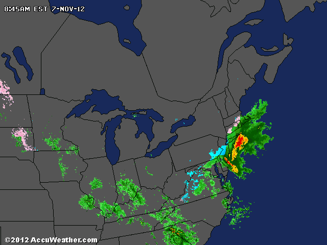
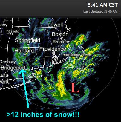
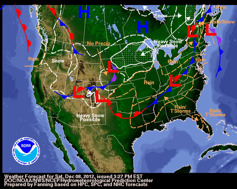
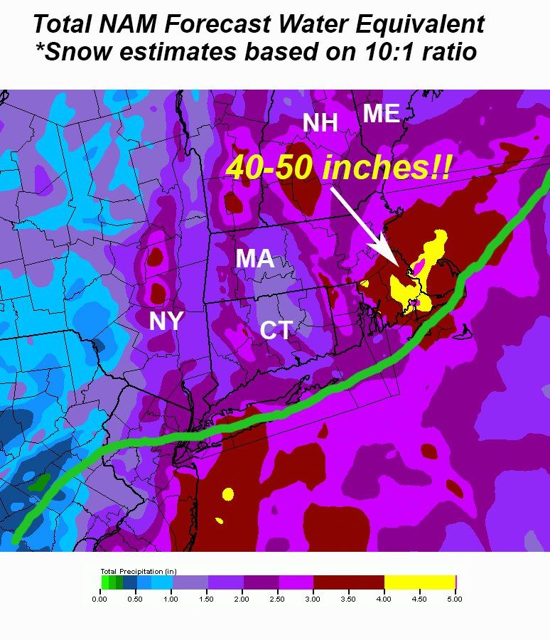
BREAKING WEATHER: BLIZZARD IN HET NOORDOOSTEN VAN DE VS
‘Tremendous snow’ wordt de komende 24 uur verwacht in het noordoosten van de Verenigde Staten. Vooral in en rond New York maar nog meer in de hoofdstad van Massachusetts, Boston, en in Providence, Rhode Island kan 50-60 centimeter sneeuw vallen. Sommige streken zullen worden geconfronteerd met een ‘all-out blizzard’. Door de enorme intensiteit van de sneeuw (tot wel 10 cm per uur!) in combinatie met hoge windsnelheden, vormen zich enorme duinen waardoor wegen volstrekt onbegaanbaar zullen zijn. Nu al ‘regent’ het vertragingen en annuleringen in het vliegverkeer.
De blizzard wordt ontketend door een tweetal depressies (zie het weerkaartje) die voor de noordoostkust van de VS gaan samensmelten. In Boston kan het qua sneeuwval de zwaarste sneeuwstorm ooit worden. Recordhouder is de sneeuwstorm van 17-18 februari 2003 (Nederland beleefde in 2003 de zonnigste sprokkelmaand ooit!) toen er 27,5 inch, omgerekend 70 centimeter, viel (zie ook het onderstaande lijstje).
De eerste sneeuw in New York viel vanochtend tussen 6 en 7 uur lokale tijd.
Jan Visser
Alvast een 'State of Emergency' voor Connecticut. Men verwacht dat veel wegen onbegaanbaar worden en ook gesloten gaan worden.
Journaals in NL vinden het nog niet interessant genoeg 
"We meet every day at the same cafe, six-thirty and no one knows she'll be there."

weet iemand waar je helder advies krijgt of het verstandig is naar New York te gaan.?
Mijn nichtje krijgt geen duidelijkheid op het reisburo. Daar doen ze (nu nog) nogal gemakkelijk
Mijn nichtje krijgt geen duidelijkheid op het reisburo. Daar doen ze (nu nog) nogal gemakkelijk
“Loop niet voor me, want ik volg niet.
Loop niet achter me, want ik leid niet.
Loop gewoon naast me en wees mijn vriend.”
Loop niet achter me, want ik leid niet.
Loop gewoon naast me en wees mijn vriend.”

Verstandig? Nee. Mogelijk? Misschien. Er zijn duizenden vluchten gecanceld en in enkele staten geldt een verbod de weg op te gaan. Nichtje kan beter checken of haar vlucht uberhaupt nog doorgaat.quote:
weet iemand waar je helder advies krijgt of het verstandig is naar New York te gaan.?
Mijn nichtje krijgt geen duidelijkheid op het reisburo. Daar doen ze (nu nog) nogal gemakkelijk
Ooit schreef oh-oh het volgende:Management en beleid en zo, dat kan elke debiel leren.
Oh, en afgezien van de sneeuwval wordt er in de kuststreken ook gewaarschuwd voor overstromingen.
Ooit schreef oh-oh het volgende:Management en beleid en zo, dat kan elke debiel leren.
|
|