WKN Weer, Klimaat en Natuurrampen
Lees alles over het onstuimige weer op onze planeet, volg orkanen en tornado's, zie hoe vulkanen uitbarsten en hoe Moeder Aarde beeft bij een aardbeving. Alles over de verwoestende kracht van onze planeet en tal van andere natuurverschijnselen.


1963 en 1956 zijn uitzonderingen, gewoon koude jaren. 2012 is niet echt koud, tot nu toe. Maar het zal me verder worst wezen, ik ga dit jaar de kou ontvluchten.quote:Op zondag 23 september 2012 12:43 schreef 12Beaufort het volgende:
[..]
1963 begon ook vroeg
http://www.schaats-en-skate.nl/cees/1963.htm#Herfst
Bah, ik heb zo'n hekel aan de winter. Ik ben ook snel een koukleum te noemen. Grote hopen sneeuw is wel leuk (mits geen school) maar na een week of twee heb ik het wel gehad, ook die enorme kou maar toch slecht ijs 
100.000 katjes
Fuck the EBU!
Fuck the EBU!

1956 was zeer uitzonderlijk. Koudste maand ooit. 1963 was 3 maanden koud.quote:
[..]
1963 en 1956 zijn uitzonderingen, gewoon koude jaren. 2012 is niet echt koud, tot nu toe. Maar het zal me verder worst wezen, ik ga dit jaar de kou ontvluchten.
v

Die winters koud? in West Europa niet bepaald..quote:Op woensdag 19 september 2012 02:44 schreef Zuidpool het volgende:
Het record aan gesmolten poolijs zorgt er voor dat we mogelijk een extreme winter tegemoet gaan. In de zomers van 2011 en 2007 smolt er ook een maximale hoeveelheid zee-ijs en de daaropvolgende winters staan te boek als erg koud. Dat meldt Trouw.nl.
Alleen februari 2012 was koud.
winter 2012
winter 2008
Neil LOVES Carrots!
Inderdaad, de winter van 2008 aanhalen als "erg koud", is nogal belachelijk van Trouw. Het was de op-zes-na warmste ooit!quote:Op maandag 24 september 2012 18:38 schreef Gitank2 het volgende:
[..]
Die winters koud? in West Europa niet bepaald..
Alleen februari 2012 was koud.
winter 2012
winter 2008
Grote kans op sneeuwrijke winter
De winter van 2012-2013 wordt koud en mogelijk sneeuwrijk,verklaard de seizoenexpert van Onlineweather. Bovendien is er in het begin van 2013 een grote kans op een Elfstedentocht en moeten we rekening houden met strenge vorst tijdens de nachten. Verder zal er in de komende winter erg veel sneeuw gaan vallen, soms kan het tijdens de sneeuwval ook flink waaien wat sneeuwduinen veroorzaakt.
Luchtfoto van de schaatspret in Nederland tijdens de winter van 2011-2012.
De verwachtingen zijn gebaseerd op afwijkingen op de Noordpool. De temperatuur ligt daar duidelijk boven normaal en de felle kouvoorraad bevindt zich boven Rusland. Deze diepvrieskou zal met aanhoudende noordoosten tot oostenwinden over west Europa gaan verspreiden.
Door het afsmelten van het ijs op de Noordpool is er veel smeltwater vrijgekomen,en heeft zich over de hele wereld verspreidt. Door hogere temperaturen rondom de ijsranden ontstaan er veel minder lagedrukgebieden in dat gebied waardoor de poolwervel veel zwakker wordt. Hogedrukgebieden boven IJsland,met flinke uitlopers naar Finland en Rusland zorgen dan voor een continue koudeaanvoer. Ook wel de Russische beer genoemd.
De maand oktober wordt naar verwachting een halve graad te zacht vergeleken met normaal. De neerslaghoeveelheden zullen normaal zijn. In november kan het voor het eerst behoorlijk koud gaan worden. De echte koudeuitbraak mogen we rond half december gaan verwachten en dan ligt Nederland al snel onder een witte deken. De decembermaand wordt tot 4 graden te koud, januari 4,2 en februari wordt zelft 4,8 c te koud.
Let wel, de winterverwachtingen zijn nooit 100% betrouwbaar. Een plotselinge afkoeling boven de Noordpool kunnen de verwachtingen plotseling de mist in laten gaan, aldus Johny Leys. Maar we gaan er van uit dat we een flinke koude winter mogen verwachten en gemeenten moeten dan ook zorgen dat er voldoende zout voorradig is om verrassingen te voorkomen!
Bron: Onlineweather
De winter van 2012-2013 wordt koud en mogelijk sneeuwrijk,verklaard de seizoenexpert van Onlineweather. Bovendien is er in het begin van 2013 een grote kans op een Elfstedentocht en moeten we rekening houden met strenge vorst tijdens de nachten. Verder zal er in de komende winter erg veel sneeuw gaan vallen, soms kan het tijdens de sneeuwval ook flink waaien wat sneeuwduinen veroorzaakt.

Luchtfoto van de schaatspret in Nederland tijdens de winter van 2011-2012.
De verwachtingen zijn gebaseerd op afwijkingen op de Noordpool. De temperatuur ligt daar duidelijk boven normaal en de felle kouvoorraad bevindt zich boven Rusland. Deze diepvrieskou zal met aanhoudende noordoosten tot oostenwinden over west Europa gaan verspreiden.
Door het afsmelten van het ijs op de Noordpool is er veel smeltwater vrijgekomen,en heeft zich over de hele wereld verspreidt. Door hogere temperaturen rondom de ijsranden ontstaan er veel minder lagedrukgebieden in dat gebied waardoor de poolwervel veel zwakker wordt. Hogedrukgebieden boven IJsland,met flinke uitlopers naar Finland en Rusland zorgen dan voor een continue koudeaanvoer. Ook wel de Russische beer genoemd.
De maand oktober wordt naar verwachting een halve graad te zacht vergeleken met normaal. De neerslaghoeveelheden zullen normaal zijn. In november kan het voor het eerst behoorlijk koud gaan worden. De echte koudeuitbraak mogen we rond half december gaan verwachten en dan ligt Nederland al snel onder een witte deken. De decembermaand wordt tot 4 graden te koud, januari 4,2 en februari wordt zelft 4,8 c te koud.
Let wel, de winterverwachtingen zijn nooit 100% betrouwbaar. Een plotselinge afkoeling boven de Noordpool kunnen de verwachtingen plotseling de mist in laten gaan, aldus Johny Leys. Maar we gaan er van uit dat we een flinke koude winter mogen verwachten en gemeenten moeten dan ook zorgen dat er voldoende zout voorradig is om verrassingen te voorkomen!
Bron: Onlineweather
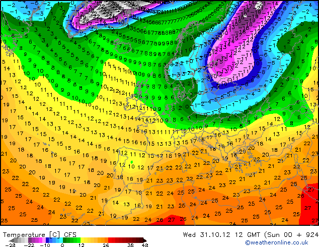
Wat een hoop sensatie om niets. JMA te koud? Eerder te warm. Ook CFS laat een duidelijk beeld zien.... Met een hoop geschreeuw, schreeuwen we de winter alleen maar weg 


Niks aan de hand dus!  Rustig afwachten, we denken het weer te kunnen voorspellen maar het gaat altijd anders. Al hopen we wel op een mooie koude winter.
Hopen mag altijd, zelf doe ik dat ook. Maar om te gaan schreeuwen dat we een enorme strenge winter gaan krijgen en dat we er niet omheen kunnen slaat nergens op. Iedereen heeft het nu al weer over dat gesmolten Noordpoolijs en dat we daarom een koude winter krijgen. Maar wat als de straalstroom noord blijft hangen?? Als ik de berichten nu lees dan wordt het nog extremer dan in 1933, toen was de 11 stedentocht op 16 december verreden.quote:
Niks aan de hand dus!
Mensen, wees een beetje aardig voor Zuidpool. Hij is hier nieuw, en wilt gewoon graag (wie niet?) dat er een strenge winter komt. En dit topic gaat erover, dus dan mag dat gewoon.
Oeh... lagedruk winterweer, ofwel een 2e herfst.quote:
Wat een hoop sensatie om niets. JMA te koud? Eerder te warm. Ook CFS laat een duidelijk beeld zien.... Met een hoop geschreeuw, schreeuwen we de winter alleen maar weg
[ afbeelding ]
[ afbeelding ]
Hoe vaak is dit soort er komt een strenge winter voorspellingen uitgekomen?
In Baden-Badener Badeseen kann man Baden-Badener baden sehen.

Net als dat andere mensen hun mening mogen geven en eventueel in twijfel trekken wat er wordt beweert of wat er verwacht wordt. Meningen verschillen, net als voorspellingen. Maar op zijn minst kan er normaal gedaan worden, kan dat niet, ga je maar elders heenquote:
Mensen, wees een beetje aardig voor Zuidpool. Hij is hier nieuw, en wilt gewoon graag (wie niet?) dat er een strenge winter komt. En dit topic gaat erover, dus dan mag dat gewoon.
Klopt, deze dingen worden helaas verzwegen. Ik verwacht dat december net als vorig jaar gewoon de prullenbak in kanquote:
[..]
Oeh... lagedruk winterweer, ofwel een 2e herfst.
CFS laat keer op keer veel kou zien in het oosten van Europa en Scandinavie. Daar moet de kou vandaan komen.
Ik geloof pas in koude winter, als ze in Oktober een warme winter voorspellen!
leven zoals het leven is
Vrijwel elk jaar zijn er individuen die zulke voorspellingen doen, ooit zal een keer een weersituatie voordoen puur door kans waardoor er eentje gelijk krijgt. Maar of die dan helderziende is.... 
Je haalt de woorden uit m'n mond.....quote:
wat een triest gedoe elk jaar weer. weet nog goed de topics van vorig jaar waar noobs, amateurweerkundigen en gerenommeerde weermannen een zeer vroege koude winter met al temperaturen van -20 in november verspelde. natuurlijk was het tegenovergestelde waar.
en nu dus weer opnieuw... dus we gaan dit elk jaar doen totdat het per toeval inderdaad vroeg winter is en dan zeker allemaal roepen "ik had het al zien aankomen".
Maar je ziet zulke voorspelling bij elk jaargetijde... Jaar in en jaar uit
<a href="http://www.vwkweb.nl/" rel="nofollow" target="_blank">[b]Vereniging voor weerkunde en klimatologie[/b]</a>
<a href="http://www.estofex.org/" rel="nofollow" target="_blank">[b]ESTOFEX[/b]</a>
<a href="http://www.estofex.org/" rel="nofollow" target="_blank">[b]ESTOFEX[/b]</a>
Optimistisch topic, CFS modellen zijn op langer termijn zeer onbetrouwbaar. Dat komt door het butterfly effect en significantie problemen. Dat in de uitdraaien van nu zeer lage temperaturen zichtbaar zijn kan misschien enkel een trend van een koudere maand weergeven. Maar om nu nou te zeggen dat het -20 C gaat worden op 20 december omdat zoiets nu in een model staat is natuurlijk onzinnig. Ik kan me herinneren dat vorig jaar een temperatuur van -44 C zichtbaar was in een model voor februari 2012. JAMSTEC Modellen geven so far juist een warmere winter helaas...
vorig jaar zou de horrorwinter toch ook al in november beginnen?
uiteindelijk kregen we pas winter in februari
uiteindelijk kregen we pas winter in februari
Where's me jumper?
Professor Steve Easterbrook is iemand die klimaatmodellen maakt en hij legt op zijn blog heel helder uit wat de grote verschillen zijn tussen het modelleren van het weer en het klimaat. Als je zijn blog leest wordt ook duidelijk waarom hetzelfde model betrouwbaar het klimaat jaren vooruit kan voorspellen maar niet het weer van over een paar maanden. En waarom we dus de voorspellingen zoals die hier in dit topic op basis van modeluitkomsten gedaan worden met een korrel zout moeten nemen.
Initial value vs. boundary value problems
Weer verwachtingen:
Klimaat modellering:
Initial value vs. boundary value problems
Weer verwachtingen:
Oftwel: kleine fouten in de initiatie van je model (observatie fouten in de huidige toestand van het weer) veroorzaken een steeds grotere cumulatieve fout hoe verder je in te toekomst kijkt. Op een gegeven moment domineren simpelweg de fouten de uitkomst.quote:Good weather forecasts depend upon an accurate knowledge of the current state of the weather system. You gather as much data you can about current temperatures, winds, clouds, etc., feed them all into a simulation model and then run it forward to see what happens. This is hard because the weather is an incredibly complex system. The amount of information needed is huge: both the data and the models are incomplete and error-prone.
Klimaat modellering:
Oftwel, het klimaat is afhankelijk van de stromen energie in het systeem en zet daarmee de grenzen van het weer. Als je de energiestromen goed hebt volgt een stabiele situatie (het klimaat) vanzelf uit de natuurwetten.quote:For understanding climate, we no longer need to worry about the initial values, we have to worry about the boundary values. These are the conditions that constraint the climate over the long term: the amount of energy received from the sun, the amount of energy radiated back into space from the earth, the amount of energy absorbed or emitted from oceans and land surfaces, and so on. If we get these boundary conditions right, we can simulate the earth’s climate for centuries, no matter what the initial conditions are. The weather itself is a chaotic system, but it operates within boundaries that keep the long term averages stable. Of course, a particularly weird choice of initial conditions will make the model behave strangely for a while, at the start of a simulation. But if the boundary conditions are right, eventually the simulation will settle down into a stable climate. (This effect is well known in chaos theory: the butterfly effect expresses the idea that the system is very sensitive to initial conditions, and attractors are what cause a chaotic system to exhibit a stable pattern over the long term)
Enigste is wat we kunnen doen is afwachten, maar neemt niet weg dat we kunnen kijken wat andere landen denken. Het is in ieders geval beter dan dat geschreeuw overal. De ene nog harder dan de andere. Zag ook al sneeuw op 9 oktober voorbij vliegen op twitter.
Ach. Ze zeggen elk jaar dat we doodvriezen in de winter.
Ik weet niks van Hindoes. Wel van Samoerai en andere dingen.
Zo hoort het, lekker neutraal en kijken wat de andere landen zeggen. Bericht is afkomstig van meteo-service
Winterverwachting 2012/2013
Na twee wintermaanden in de winter van 2011/2012 met zacht en wisselvallig weer werd het pas in februari echt winters met strenge vorst, sneeuwbuien en ijs. Door de vaak sterke oostenwind voelt het soms ook bijzonder koud aan met zeer lage gevoelstemperaturen tot gevolg. Deze koudegolf is bijzonder voor Nederland maar het hoort ook bij ons wisselvallig klimaat. De koudegolf van de winter van 2012 was de 33e sinds 1901 en de eerste in vijftien jaar. De vorige, die twaalf dagen duurde en een Elfstedentocht mogelijk maakte, beleefde ons land begin 1997. De koudegolf van 30 januari tot en met 8 februari 2012 duurde tien dagen en bood te weinig vorst voor een Elfstedentocht maar leverde wel mooie schaatsdagen op. De zon scheen uitbundig: de eerste decade van februari was in De Bilt met 62 uur zon de zonnigste van de meetreeks, aldus het KNMI.
De verwachting
Momenteel zijn er vele verwachtingen te zien op internet, de ene nog sensationeler dan de andere. Ook op diverse buitenlandse sites staan er een paar. Donnerwetter heeft momenteel nog geen verwachting online staan, mogelijk komt dit wel door de horrorwinter die ze toen verwachtte. Een aantal (bekende) websites uit Italië, Engeland, Frankrijk en Oostenrijk hebben al een verwachting staan, al dan niet een voorlopige verwachting. Hieronder ziet u kort samengevat wat die schrijven. Maar voordat we dat doen kijken we eerst even wat Johann onlangs op Sneeuwhoogte.nl geschreven heeft:
Sinds ongeveer een half jaar zien we een positieve anomalie in de temperaturen van het oppervlaktewater (3-5 graden) voor de kust van de US tot in het zeegebied van Groenland inclusief de Hudsonbaai (kaart hieronder). Deze anomalie valt niet (alleen) te verklaren door de NAO (maatstaf voor het verschil in luchtdruk tussen de depressie bij IJsland en het hogedrukgebied bij de Azoren. Waarschijnlijk wordt ze veroorzaakt door een afwijkend patroon in het verloop van de Golfstroom en de Noord Atlantische Current (NAC). Doordat de Labradorstroming en de NAC "botsen" wordt het warme water uit zuidelijke breedtegraden deels richting Groenland omgeleid. Eerder al had Greenpeace middels metingen een "subtropische zeestroming" vastgesteld, deze zou dan ook mede verantwoordelijk kunnen zijn voor het versneld afsmelten van het (gletsjer) ijs bij Groenland.
Sea Surface Temperature anomalie (SST) of tewel de afwijking van het oppervlaktewater (in °C)
De positeve SST anomalie zagen we de laatste jaren al vaker en deze ging vaak gepaard met een overwegend negatieve NAO. Het in kracht afnemen van de NAO wordt wederom veroorzaakt door de afname van de temperatuurgradiënt van het oppervlaktewater van de Oceaan. Hierdoor komt de "energietoevoer" in de "kraamkamer" van "onze" depressies op een lager pitje te staan met als resultaat een afname van de depressie activiteit en dus een afgezwakte westdrift (jetstream). Daarbij is de kans op overheersende meridionale stromingspatronen (noord >< zuid) groter dan die van zonaal (west). Mocht het allemaal zo gaan verlopen dan mogen we, evenals in de voorgaande jaren met een positieve SST, ook dit jaar weer uitgaan van minstens 1 duidelijk te koude wintermaand in West Europa. Af te wachten valt nog in hoeverre "El Niño" invloed zal uitoefenen op het stromingspatroon, daarover kunnen we nu alleen nog maar speculeren. Dit geldt eveneens voor de invloed van de zonnencyclus(activiteit).
Als we de andere landen erbij gaan pakken zoals Duitsland, Italië, Oostenrijk, Frankrijk en Engeland dan zien we dat er een enorm groot verschil in zit qua verwachtingspatroon. Voor de mensen die van winter houden lijken de updates van Oostenrijk en Engeland het beste. Maar goed.... We weten allemaal dat het gaat om lange termijnverwachting en de kans dat het uitkomt is zeer klein. We zijn immers afhankelijk van wat de modellen ons voorschotelen op dit moment!
Italiaanse update
Het eerste deel van de maand december moeten we snel vergeten, zoals nu verwacht wordt is er geen teken van winter te zien. Aan het einde van de maand lijkt zich er een hogedrukgebied zich te vestigen ter hoogte van Scandinavië. Dit zal niet zonder slag of stoot gaan. Begin januari lijkt alles goed te komen, depressies zullen ten zuiden van Nederland passeren, maar de vraag is nog altijd hoever zuidelijk. Mocht alles zo gaan vallen als in de wintermaanden van 2010 dan kunnen we ons opmaken voor aardig wat sneeuw. De maand februari lijkt verstoord te gaan worden door depressies vanuit het westen. In de Italiaanse update wordt ook gesproken over een winter die normaal tot zelfs ietsjes te warm zal gaan verlopen.
Duitse update
Ook de Duitsers hebben een voorlopige update geschreven, deze zijn niet zo kapot van de aankomende winter. Ze hebben een berekening gemaakt en aan de hand van die berekening een percentage gemaakt. Ze kwamen uit op 39% normaal winter, warme winter tot 32% en een te koude winter 29%. Zie hier het kaartje.
Oostenrijkse update
De Oostenrijkse update ziet er een stukje beter uit dan de Duitse update. Wel moeten we erbij vermelden dat deze update alleen geldig is voor Oostenrijk. Helaas is er alleen nog maar data beschikbaar voor de eerste wintermaand, december dus. Deze maand laat de winter grillig beginnen. De oorzaak hiervan kan liggen aan een gebied van hogedruk boven Rusland dat koude lucht naar midden en west Europa. De berekeningen aan de hand van de recente weermodellen laten zien dat de kans bestaat dat de maand december te koud gaat verlopen in Oostenrijk. Helaas moeten we de neerlag verschuldigd blijven. Ook hier werken ze met percentages met koud, normaal en te warm. Volgens de recente kaart zal het 75% kouder dan normaal zijn, het overige (normale tot warmere temperaturen) zal 25% zijn. Zie hier het kaartje.
De Fransen
De Fransen zien het wel zitten deze winter, die verwachten een mooie koude-uitbraak vanuit Scandinavië. De koude-uitbraak zal zich snel positioneren boven Europa. Ook hier dekken ze zich aardig in, want er wordt medegedeeld dat ze niet weten wat de omvang van de koude-uitbraak zal zijn voor west Europa. Wel gaan ze voor een meest droge periode. Zie afbeelding hieronder.
De Engelsen
Weather Services International heeft ook al de eerste wintermaand in hun prognose staan, deze zal naar verwachting warmer dan normaal gaan verlopen. Binnenkort komen ze daar ook met de maanden januari en februari. Echter de Britse meteodienst MetOffice spant toch wel de kroon. De seizoensverwachting die ze daar momenteel weergeven laat zien dat de maanden december, januari en februari gemiddeld te koud gaan verlopen, maar ook droger. Zie afbeelding.
Winterverwachting 2012/2013
Na twee wintermaanden in de winter van 2011/2012 met zacht en wisselvallig weer werd het pas in februari echt winters met strenge vorst, sneeuwbuien en ijs. Door de vaak sterke oostenwind voelt het soms ook bijzonder koud aan met zeer lage gevoelstemperaturen tot gevolg. Deze koudegolf is bijzonder voor Nederland maar het hoort ook bij ons wisselvallig klimaat. De koudegolf van de winter van 2012 was de 33e sinds 1901 en de eerste in vijftien jaar. De vorige, die twaalf dagen duurde en een Elfstedentocht mogelijk maakte, beleefde ons land begin 1997. De koudegolf van 30 januari tot en met 8 februari 2012 duurde tien dagen en bood te weinig vorst voor een Elfstedentocht maar leverde wel mooie schaatsdagen op. De zon scheen uitbundig: de eerste decade van februari was in De Bilt met 62 uur zon de zonnigste van de meetreeks, aldus het KNMI.
De verwachting
Momenteel zijn er vele verwachtingen te zien op internet, de ene nog sensationeler dan de andere. Ook op diverse buitenlandse sites staan er een paar. Donnerwetter heeft momenteel nog geen verwachting online staan, mogelijk komt dit wel door de horrorwinter die ze toen verwachtte. Een aantal (bekende) websites uit Italië, Engeland, Frankrijk en Oostenrijk hebben al een verwachting staan, al dan niet een voorlopige verwachting. Hieronder ziet u kort samengevat wat die schrijven. Maar voordat we dat doen kijken we eerst even wat Johann onlangs op Sneeuwhoogte.nl geschreven heeft:
Sinds ongeveer een half jaar zien we een positieve anomalie in de temperaturen van het oppervlaktewater (3-5 graden) voor de kust van de US tot in het zeegebied van Groenland inclusief de Hudsonbaai (kaart hieronder). Deze anomalie valt niet (alleen) te verklaren door de NAO (maatstaf voor het verschil in luchtdruk tussen de depressie bij IJsland en het hogedrukgebied bij de Azoren. Waarschijnlijk wordt ze veroorzaakt door een afwijkend patroon in het verloop van de Golfstroom en de Noord Atlantische Current (NAC). Doordat de Labradorstroming en de NAC "botsen" wordt het warme water uit zuidelijke breedtegraden deels richting Groenland omgeleid. Eerder al had Greenpeace middels metingen een "subtropische zeestroming" vastgesteld, deze zou dan ook mede verantwoordelijk kunnen zijn voor het versneld afsmelten van het (gletsjer) ijs bij Groenland.

Sea Surface Temperature anomalie (SST) of tewel de afwijking van het oppervlaktewater (in °C)
De positeve SST anomalie zagen we de laatste jaren al vaker en deze ging vaak gepaard met een overwegend negatieve NAO. Het in kracht afnemen van de NAO wordt wederom veroorzaakt door de afname van de temperatuurgradiënt van het oppervlaktewater van de Oceaan. Hierdoor komt de "energietoevoer" in de "kraamkamer" van "onze" depressies op een lager pitje te staan met als resultaat een afname van de depressie activiteit en dus een afgezwakte westdrift (jetstream). Daarbij is de kans op overheersende meridionale stromingspatronen (noord >< zuid) groter dan die van zonaal (west). Mocht het allemaal zo gaan verlopen dan mogen we, evenals in de voorgaande jaren met een positieve SST, ook dit jaar weer uitgaan van minstens 1 duidelijk te koude wintermaand in West Europa. Af te wachten valt nog in hoeverre "El Niño" invloed zal uitoefenen op het stromingspatroon, daarover kunnen we nu alleen nog maar speculeren. Dit geldt eveneens voor de invloed van de zonnencyclus(activiteit).
Als we de andere landen erbij gaan pakken zoals Duitsland, Italië, Oostenrijk, Frankrijk en Engeland dan zien we dat er een enorm groot verschil in zit qua verwachtingspatroon. Voor de mensen die van winter houden lijken de updates van Oostenrijk en Engeland het beste. Maar goed.... We weten allemaal dat het gaat om lange termijnverwachting en de kans dat het uitkomt is zeer klein. We zijn immers afhankelijk van wat de modellen ons voorschotelen op dit moment!
Italiaanse update
Het eerste deel van de maand december moeten we snel vergeten, zoals nu verwacht wordt is er geen teken van winter te zien. Aan het einde van de maand lijkt zich er een hogedrukgebied zich te vestigen ter hoogte van Scandinavië. Dit zal niet zonder slag of stoot gaan. Begin januari lijkt alles goed te komen, depressies zullen ten zuiden van Nederland passeren, maar de vraag is nog altijd hoever zuidelijk. Mocht alles zo gaan vallen als in de wintermaanden van 2010 dan kunnen we ons opmaken voor aardig wat sneeuw. De maand februari lijkt verstoord te gaan worden door depressies vanuit het westen. In de Italiaanse update wordt ook gesproken over een winter die normaal tot zelfs ietsjes te warm zal gaan verlopen.
Duitse update
Ook de Duitsers hebben een voorlopige update geschreven, deze zijn niet zo kapot van de aankomende winter. Ze hebben een berekening gemaakt en aan de hand van die berekening een percentage gemaakt. Ze kwamen uit op 39% normaal winter, warme winter tot 32% en een te koude winter 29%. Zie hier het kaartje.
Oostenrijkse update
De Oostenrijkse update ziet er een stukje beter uit dan de Duitse update. Wel moeten we erbij vermelden dat deze update alleen geldig is voor Oostenrijk. Helaas is er alleen nog maar data beschikbaar voor de eerste wintermaand, december dus. Deze maand laat de winter grillig beginnen. De oorzaak hiervan kan liggen aan een gebied van hogedruk boven Rusland dat koude lucht naar midden en west Europa. De berekeningen aan de hand van de recente weermodellen laten zien dat de kans bestaat dat de maand december te koud gaat verlopen in Oostenrijk. Helaas moeten we de neerlag verschuldigd blijven. Ook hier werken ze met percentages met koud, normaal en te warm. Volgens de recente kaart zal het 75% kouder dan normaal zijn, het overige (normale tot warmere temperaturen) zal 25% zijn. Zie hier het kaartje.
De Fransen
De Fransen zien het wel zitten deze winter, die verwachten een mooie koude-uitbraak vanuit Scandinavië. De koude-uitbraak zal zich snel positioneren boven Europa. Ook hier dekken ze zich aardig in, want er wordt medegedeeld dat ze niet weten wat de omvang van de koude-uitbraak zal zijn voor west Europa. Wel gaan ze voor een meest droge periode. Zie afbeelding hieronder.

De Engelsen
Weather Services International heeft ook al de eerste wintermaand in hun prognose staan, deze zal naar verwachting warmer dan normaal gaan verlopen. Binnenkort komen ze daar ook met de maanden januari en februari. Echter de Britse meteodienst MetOffice spant toch wel de kroon. De seizoensverwachting die ze daar momenteel weergeven laat zien dat de maanden december, januari en februari gemiddeld te koud gaan verlopen, maar ook droger. Zie afbeelding.
Er is natuurlijk altijd een 50% kans dat een winter kouder is als gemiddeld, en een kans van 50% dat een winter warmer is dan gemiddeld. Daarvoor is het nou eenmaal een gemiddelde. Aan vage termen als 'te koud' en 'de eerste maanden van de winter' hebben we dus niks
De vraag is: wat bedoelen deze weerbureaus met 'te koud', 'te warm' en 'gemiddeld'? Ik wil weten wat ze voorspellen aan afwijking van het gemiddeld in graden Celcius en exact over welke periode, zodat ik achteraf kan controleren of ze gelijk hebben of niet. En what the hell is "75% kouder dan normaal"? 75% van 5.6 graden Celcius? Of 75% van Europa of wat?
Dat vage gedoe klinkt allemaal hartstikke leuk maar daar hebben we niks aan, net zo min als toen die keer dat de waarzegster zei: "binnenkort heb je pech". En verdomd, ging een dag later het stoplicht niet net op rood toen ik eraan kwam? Echt waar, ik zweer het je, die waarzegster wist precies wat er ging gebeuren... Oftwel, als je het maar lekker vaag houd dan krijg je altijd gelijk.
Simon Keeling's winterverwachting. (Groot-Brittannië)
As always, these predictions are based on my research into long-range UK weather patterns and various influencing factors, to give a general overview of the season ahead, and also pinpointing a few ‘watch periods’ where there is an enhanced likelihood of ‘interesting’ weather. The details described here are putting some ideas to the test, and will be interesting to see if they have any accuracy throughout this season. More specific ideas for each upcoming month will be posted nearer the time, so keep up to date with these blogs!
Summary: A wet and stormy autumn, with gales and flooding likely in the west and south-west, generally quite mild. A stormy start to winter, with threat of coastal flooding from high seas, but then a period of significant cold and snow possible.
OCTOBER:
1-7 OCT:
A mixed start to the month, with periods of rain and heavy squally showers mixed in with some brighter days during the first 7 days.Generally cool and unsettled, with west to north-westerly winds. Some quite lively showers for many parts of the UK, with some heavier spells of rain in the west and north-west of the UK.
8-18 OCT
High pressure in the south and south-west should try and feed warmer air towards the UK during the middle of the month, and if the airflow swings further to the south some warm days into the 20s may appear, although upper teens seems generally more likely. More unsettled in the north-west with stronger winds, drier and brighter in the south-east. By the end of this period southern Britain more likely to turn unsettled, with rain trying to affect most areas, possibly paving the way for a pretty unsettled second half of the month.
19-31 OCT
Low pressure likely to be a regular feature of late October, and could become anchored in the south-west through this period. Becoming increasingly unsettled during the final 10 days, with heavy rain and gales bringing problems by the end of the month. Wales and the south-west looking particularly vulnerable to flooding by late October. North-eastern Britain may turn quite cold by the last week of the month, with some early snow over northern mountains and hills.
WATCH PERIOD: 25-30 OCT: HEAVY RAIN & GALES – Esp. SW UK
NOVEMBER:
A month of two halves for temperatures. There could be some quite mild or even warm days early in the month with frequent south to south-westerly airflows. Drier in the east and south-east of the UK, but the risk of very heavy rain over Wales, north-west England and Scotland, bringing renewed risk of flooding. WATCH PERIOD: 10-16 NOV: WET IN THE WEST
Becoming much colder after mid-month with more frequent northerly winds and the risk of snow in the north and east of the UK. This initial spell of cooler weather would be unlikely to last too long, as westerly winds would return by the end of the month.
WATCH PERIOD: 20-25 NOV: COLD SNAP – SNOW RISK
DECEMBER:
A fairly mild beginning to the month, with west or south-westerly airflows bringing frequent wind and rain to the north-west of the UK in particular. This may ramp up into significant storms during the early part of December, with severe gales and flooding rainfall, with high seas threatening coastal flooding. If storm systems cut further south, then snowfall becomes increasingly likely.
WATCH PERIOD: 8-14 DEC: STORMY, FLOODING NW UK, GALES AND HIGH SEAS
The positioning of high pressure systems will become crucial through the middle of the month, because this is where a true spell of significant winter weather may develop. Obviously at this stage it is very difficult to pinpoint exact patterns and timings, but there is a realistic threat of a sustained cold and snowy period from mid-December onwards, lasting through Christmas and into the first part of January. Extremely cold temperatures and problems with snow, with easterly air dominating northern Europe for a period as blocking high pressure becomes established over Scandinavia and north of the UK. I just have a question mark about when this period begins, whether it really gets going in December or is more centred on January. It will require close attention as we get nearer the time, but there looks to be scope for troublesome cold weather in this period. WATCH PERIOD: 18 DEC ONWARDS: COLD AND SNOW
EARLY 2013:
A milder spell develops for a time after this potential freeze-up, so winter may disappear for a while, but later January and into February could see strong storms getting mixed in with cold northerly air, bringing the risk of blizzard conditions across the north of the UK as gales and snow combine, but cold periods would be shorter and mixed in with milder westerly weather.
www.weatherweb.net/wxwebtvreporter.php?ID=473
Er zijn trends deze zomer, er zijn trends in de herfst en natuurlijk ook in de winter. Persoonlijk vind ik het heel gevaarlijk om een uitspraak te doen (zeker met de recordafname van het ijs op de Noordpool en de eventuele invloed op de jetstream). Daarom is het verstandig om te kijken naar wat de rest zegt en misschien later een uitspraak te doen?
Een nuchtere blik op de winter 2012-2013
Een nuchtere blik op de winter 2012-2013
Fan van noodweer: http://www.weerstationwaregem.be
Hoe groot is de kans op een Elfstedentocht de komende winter?
Hoe groot is de kans dat we de komende winter 2012 – 2013 weer eens een ouderwetse Elfstedentocht tegemoet kunnen zien ? De koude winters van de afgelopen jaren zouden best eens een aanwijzing kunnen vormen dat de Tocht der Tochten er aan zit te komen.
Prognoses voor de komende winter.
Mijn verwachtingen voor de komende winter heb ik verwoord in het artikel “ Wordt de winter 2012- 2013 streng of wordt het een kwakkelwinter?” In dit artikel zijn op grond van onder andere zogenaamde “koudegetallen”, zonnecyclus en zeestromingen de verwachtingen voor de komende winter geanalyseerd. Met name de zonnecyclus, oftewel de activiteit van de zon in grafieken vastgelegd, biedt hoop voor winterliefhebbers. Maar liefst 11 van de 15 Elfstedentochten tot nu toe zijn gehouden op momenten dat er sprake was van relatief weinig activiteit van de zon. En ook nu is er, ondanks een aantal felle uitbarstingen afgelopen voorjaar, sprake van een historisch onnatuurlijke grafiek, welke het aantal zonnevlekken weergeeft. Waar rond 2012 – 2013 sprake zou moeten zijn van een duidelijke top in de grafiek, is die weliswaar zichtbaar, maar in volume slechts half zo groot als normaal. Tot na 2017 zien we normaal gesproken alleen nog maar een afname van de waarden.
Er zijn dan ook hypotheses dat we een langere periode, mogelijk decennia, met weinig zonactiviteit tegemoet kunnen zien. In dit licht bezien doet zich onmiddellijk de vergelijking gelden met de periode tussen ca. 1645 en 1715,ook wel de "kleine ijstijd" genoemd, waarin de zon gedurende tientallen jaren nagenoeg geen activiteit liet zien. In deze periode daalde de gemiddelde temperatuur wereldwijd significant. Afgezien van het weer zijn er overigens nog een aantal factoren, die er wellicht toe bijdragen dat een Elfstedentocht in de toekomst – en wellicht komende winter- tot de mogelijkheden behoort.
Overige factoren
Waar vroeger puur vrieskou moest zorgen voor voldoende ijsdikte om de tienduizenden schaatsers een veilige tocht te kunnen garanderen, zijn er tegenwoordig technieken om knelpunten van een voldoende dikke ijslaag te voorzien; bijvoorbeeld onder bruggen is de ijsdikte vaak een probleem. Om knelpunten in de vorm van open stukken water en wakken te behandelen kan men gebruik maken van zgn. "ïjstransplantatie”. Hierbij worden dikke brokken ijs van elders in het water gebracht, waardoor het water afkoelt en de basis is gevormd voor snelle ijsaangroei.
Maar er zijn meer mogelijkheden om plaatselijk snel een voldoende dikke ijsvloer te realiseren. De meest in het oog springende manier om dit te verwezenlijken is met behulp van “droogijs” , een vaste vorm van CO2, ook wel koolzuursneeuw genoemd. Deze stof zorgt voor een zeer snelle afkoeling tot wel 50 graden onder nul; op onvoldoende dik ijs gestrooid zorgt het droogijs ervoor dat het ijs aan de onderkant snel aangroeit – in een uur wel 2 cm.
Een andere factor die – uiteraard bij voldoende vorst – kan zorgen voor een zo snel mogelijke Elfstedentocht is het via provincie en waterschappen zo gauw mogelijk invoeren van een vaarverbod en het stilleggen van bemalingen, sluizen en stuwen, waardoor het waterpeil zo constant mogelijk blijft en stromingen beperkt blijven. Vorig jaar al zagen we de resultaten van dergelijke gecoördineerde acties, waaronder we ook kunnen rekenen het in een later stadium waar nodig met groot materieel en veel manschappen sneeuwvrij maken van het ijs. Zelfs kunnen in het uiterste geval onbetrouwbare gedeelten in de route vervangen worden door alternatieve routegedeelten. Ook de afgelopen winter kwam een dergelijke noodoplossing nog ter sprake.
Conclusie
Gezien de trend van de winters de afgelopen jaren, zulks mogelijk veroorzaakt door de geringe activiteit van de zon, lijkt een Elfstedentocht de komende winter heel wel mogelijk, mede gelet op de mogelijkheden om knelpunten in de route te behandelen.
Bron: Plazilla
Hoe groot is de kans dat we de komende winter 2012 – 2013 weer eens een ouderwetse Elfstedentocht tegemoet kunnen zien ? De koude winters van de afgelopen jaren zouden best eens een aanwijzing kunnen vormen dat de Tocht der Tochten er aan zit te komen.
Prognoses voor de komende winter.
Mijn verwachtingen voor de komende winter heb ik verwoord in het artikel “ Wordt de winter 2012- 2013 streng of wordt het een kwakkelwinter?” In dit artikel zijn op grond van onder andere zogenaamde “koudegetallen”, zonnecyclus en zeestromingen de verwachtingen voor de komende winter geanalyseerd. Met name de zonnecyclus, oftewel de activiteit van de zon in grafieken vastgelegd, biedt hoop voor winterliefhebbers. Maar liefst 11 van de 15 Elfstedentochten tot nu toe zijn gehouden op momenten dat er sprake was van relatief weinig activiteit van de zon. En ook nu is er, ondanks een aantal felle uitbarstingen afgelopen voorjaar, sprake van een historisch onnatuurlijke grafiek, welke het aantal zonnevlekken weergeeft. Waar rond 2012 – 2013 sprake zou moeten zijn van een duidelijke top in de grafiek, is die weliswaar zichtbaar, maar in volume slechts half zo groot als normaal. Tot na 2017 zien we normaal gesproken alleen nog maar een afname van de waarden.

Er zijn dan ook hypotheses dat we een langere periode, mogelijk decennia, met weinig zonactiviteit tegemoet kunnen zien. In dit licht bezien doet zich onmiddellijk de vergelijking gelden met de periode tussen ca. 1645 en 1715,ook wel de "kleine ijstijd" genoemd, waarin de zon gedurende tientallen jaren nagenoeg geen activiteit liet zien. In deze periode daalde de gemiddelde temperatuur wereldwijd significant. Afgezien van het weer zijn er overigens nog een aantal factoren, die er wellicht toe bijdragen dat een Elfstedentocht in de toekomst – en wellicht komende winter- tot de mogelijkheden behoort.
Overige factoren
Waar vroeger puur vrieskou moest zorgen voor voldoende ijsdikte om de tienduizenden schaatsers een veilige tocht te kunnen garanderen, zijn er tegenwoordig technieken om knelpunten van een voldoende dikke ijslaag te voorzien; bijvoorbeeld onder bruggen is de ijsdikte vaak een probleem. Om knelpunten in de vorm van open stukken water en wakken te behandelen kan men gebruik maken van zgn. "ïjstransplantatie”. Hierbij worden dikke brokken ijs van elders in het water gebracht, waardoor het water afkoelt en de basis is gevormd voor snelle ijsaangroei.
Maar er zijn meer mogelijkheden om plaatselijk snel een voldoende dikke ijsvloer te realiseren. De meest in het oog springende manier om dit te verwezenlijken is met behulp van “droogijs” , een vaste vorm van CO2, ook wel koolzuursneeuw genoemd. Deze stof zorgt voor een zeer snelle afkoeling tot wel 50 graden onder nul; op onvoldoende dik ijs gestrooid zorgt het droogijs ervoor dat het ijs aan de onderkant snel aangroeit – in een uur wel 2 cm.

Een andere factor die – uiteraard bij voldoende vorst – kan zorgen voor een zo snel mogelijke Elfstedentocht is het via provincie en waterschappen zo gauw mogelijk invoeren van een vaarverbod en het stilleggen van bemalingen, sluizen en stuwen, waardoor het waterpeil zo constant mogelijk blijft en stromingen beperkt blijven. Vorig jaar al zagen we de resultaten van dergelijke gecoördineerde acties, waaronder we ook kunnen rekenen het in een later stadium waar nodig met groot materieel en veel manschappen sneeuwvrij maken van het ijs. Zelfs kunnen in het uiterste geval onbetrouwbare gedeelten in de route vervangen worden door alternatieve routegedeelten. Ook de afgelopen winter kwam een dergelijke noodoplossing nog ter sprake.
Conclusie
Gezien de trend van de winters de afgelopen jaren, zulks mogelijk veroorzaakt door de geringe activiteit van de zon, lijkt een Elfstedentocht de komende winter heel wel mogelijk, mede gelet op de mogelijkheden om knelpunten in de route te behandelen.
Bron: Plazilla
Er komen steeds meer factoren bij die ons moeten garanderen dat we een strenge winter tegemoet gaan...........
Ik ga nergens van uit en ik merk het wel, dit soort berichten is leuk maar ieder jaar pakken dit soort vervroegde berichten weer verkeerd uit!
Ik ga nergens van uit en ik merk het wel, dit soort berichten is leuk maar ieder jaar pakken dit soort vervroegde berichten weer verkeerd uit!
Zonder wrijving geen glans
Even de kaartjes van meteo-service forum gepakt:
Ja hoor, daar is het dan.... Het eerste kaartje met wat sneeuw voor Nederland en België. Ardennen eerste dumpje van het seizoen?
Ja hoor, daar is het dan.... Het eerste kaartje met wat sneeuw voor Nederland en België. Ardennen eerste dumpje van het seizoen?


Al die weeridioten roepen in de herfst wat over de winter, streng, kwakkel, etc altijd goed voor je grafkop in de krant en bij 10 zulke gekken heeft er altijd wel 1 gelijk
In Baden-Badener Badeseen kann man Baden-Badener baden sehen.
Die idioten praten over een normale winter daarquote:
Al die weeridioten roepen in de herfst wat over de winter, streng, kwakkel, etc altijd goed voor je grafkop in de krant en bij 10 zulke gekken heeft er altijd wel 1 gelijk

bron: Jan Visserquote:SPANNENDE ONTWIKKELINGEN ROND DE MAANDWISSELING
Het is (nog) niet vanzelfsprekend dat de ‘neergaande trend’, onder het aan het ECMWF gelieerde ‘ledenbestand’, begin december tot winterweer gaat leiden maar de voortekenen zijn wel hoopvol. Ten noorden van de 60ste breedtegraad lijkt zich namelijk een tamelijk solide gordel van hogedrukgebieden op te bouwen. In de atmosferische bovenkamer bouwt zich bovendien (ten oosten van Groenland) een hogedrukblokkade op terwijl tegelijkertijd Noord-Rusland het verzamelcentrum van koude luchtmassa’s gaat worden. Spannende ontwikkelingen dus!
Gedurende de laatste week van november snoert zich boven West-Europa in een brede hoogtetrog een lagedrukgebied af. De atmosfeer verkilt enigszins maar de lucht is vochtig zodat het vaak bewolkt zal zijn met kans op enige neerslag.
[ Bericht 4% gewijzigd door #ANONIEM op 20-11-2012 22:45:03 ]

|
|