WKN Weer, Klimaat en Natuurrampen
Lees alles over het onstuimige weer op onze planeet, volg orkanen en tornado's, zie hoe vulkanen uitbarsten en hoe Moeder Aarde beeft bij een aardbeving. Alles over de verwoestende kracht van onze planeet en tal van andere natuurverschijnselen.


El Golfo, El Hierro, De plek waar de meeste aardbevingen zijn geregistreerd
quote:Recordaantal aardbevingen op Canarisch eiland
Nog nooit eerder werden er zoveel aardbevingen achter elkaar geregistreerd op het kleine vulkanische eilandje El Hierro, het kleinste van de Canarische Eilanden. De reeks van maar liefst 720 bevinkjes heeft de overheid van deze eilandengroep voor de kust van West Afrika ertoe doen besluiten om voor het eerst in de geschiedenis een vergadering bijeen te roepen van het Stuurcomité van Vulkanische Monitoring. Dit comité werd opgericht om specifieke plannen te realiseren, die de burgerbevolking dienen te beschermen en noodplannen voor vulkanische risico’s moeten ontwikkelen. Inmiddels wordt gesproken over een ‘significante dreiging van seismische activiteit’.
Het Nationaal Geografisch Instituut (IGN) en het Volcanologische Instituut van de Canarische eilanden blijft nauwlettend de aardbevingen in de gaten houden, waarvan de kracht van de bevingen (elke dag!) ligt tussen de 1 en 3 op de Richterschaal. De meerderheid van de bevingen vindt plaats tussen 5 en 15 km diepte.
Volgens de autoriteiten betekent deze seismische activiteit nog niet direct dat een grotere, significante aardbeving zal plaatsvinden. Het merendeel van de bevingen die zijn geregistreerd, vonden plaats in het Noord Westen van het 280 vierkante kilometer kleine eilandje, bij het plaatsje El Golfo (zie foto hieronder). Een aardbeving op deze plaats zorgde er zo’n 50.000 jaar geleden voor, dat er een enorme landverschuiving plaatsvond, waarbij de helft van de vulkaan in zee gleed. Hierdoor ontstond een ca. 100 meter hoge tsunami die naar de overzijde van de Atlantische oceaan zou zijn gegleden. Schuin tegenover dit eilandje, in het verlengde van de resterende halve kratermond, ligt het Noord Amerikaanse continent..
quote:El Hierro Earthquake Swarm Enters Third Week
The intensity of earthquakes recorded on the smallest of the Canary Islands, El Hierro, has increased slightly during the last 24 hours. However, the total number of earthquakes recorded daily has lessened since the earthquake swarm initially began on 17 July.
The total number of tremors recorded during the past two weeks has now exceeded 1,050, according to the Instituto Geografico Nacional (IGN).
The majority of the earth tremors ranged between 1-2 magnitude, but during the past 24 hours there have been least five tremors measuring in excess of 2.0 magnitude on the Richter Scale. A 2.4 magnitude earthquake was recorded at 4:56 p.m. local time on Sunday (31 July 2011).
Approximately 50 earth tremors were recorded on Sunday, according to local earthquake monitoring agency Actualidad Volcánica de Canarias (AVCAN). The number is slightly down on the number of tremors recorded on Saturday and significantly less than the 195 earthquakes recorded on 22 July.

Recorded tremors last days
quote:The vast majority of the tremors have been recorded in the northwest of the 278.5-square-kilometre island at El Golfo, the location of a massive landslide that created a 100-metre high tsunami almost 50,000 years ago.
The earthquake swarm, prompted the Canary Islands Government to convene the first ever meeting on 22 July of the Steering Committee and Volcanic Monitoring, reflected in the Specific Plan Protection Civil and Emergency for Volcanic Risk, given what it described “the significant increase in seismic activity”. The Committee met again on Friday 29 July to discuss the low magnitude seismic activity. It reported that it had stepped up its seismic monitoring operations to identify the source of the earthquakes.
Following an evaluation of seismic and volcanological information gathered by the IGN and volcanological Institute of the Canary Islands, the Committee agreed to activate “monitoring and surveillance mechanisms necessary to coordinate the actions of civilian self-protection and information to people listed in the Plan” (translated from Spanish press release). It remains unclear, however, if the unprecedented seismic activitiy on El Hierro is a precursor to a possible future increase in earthquake or volcanic activity.
Earthquake swarms are events where a local area experiences sequences of many earthquakes striking in a relatively short period of time. The length of time used to define the swarm itself varies, but the United States Geological Survey (USGS) points out that an event may last for days, weeks, or months.
El Hierro’s Volcanic/Seismic Past
El Hierro is situated in the most southwestern extreme of the Canaries. The island was formed after three successive eruptions, and consequent accumulations, the island emerged from the ocean as an imposing triangular pyramid crowned by a volcano more than 2,000 metres high.
The volcanic activity, principally at the convergence of the three ridges, resulted in the continual expansion of the island. A mere 50,000 years ago, as a result of seismic tremors which produced massive landslides, a giant piece of the island cracked off, crashed down into the ocean and scattered along the seabed. This landslide of more than 300km3 gave rise to the impressive amphitheatre of the El Golfo valley and at the same time caused a tsunami that most likely rose over 100 metres high and probably reached as far as the American coast.


Links
Actuele seismische activiteit
AVCan - vulcanologiesch instituut Canarische eilanden
Spaans geografisch instituut
Canariesnews
Tumbit
en op twitter kun je zoeken op #hierro, #elhierro of #viveelhierro
@noticiacanaria Wel veel ander nieuws
@canariesnews
@eruptionsblog
@teideano 1 van de onderzoekers op El Hierro
Gerelateerde topics
[Vulkanen] The ring of fire #6: Waar diverse vulkanen puffen
Aardbevingen #12
Mega tsunami door in zee vallen van eiland La Palma?
[ Bericht 4% gewijzigd door Frutsel op 19-10-2011 14:59:04 ]
Latest update on El Hierro
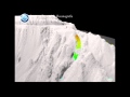
From the harmonic tremor data during the current eruption in El Hierro. It seems that the eruption has dropped in strength during the past 48 hours or so. But that most likely means that the current eruption crater is closing up. But this does not mean that the eruption is over, as new fissures might open up without any warning close the El Hierro Island or on the island it self. It is impossible to know that for sure at this moment. As it currently stands it is unlikely that a new Island is going to form offshore of El Hierro island, as the current eruption crater does not seem to have the energy to break the surface of the ocean. Earthquake activity in El Hierro volcano remains about the same as it has since the eruption did start on 10 October, 2011.
Harmonic tremor in El Hierro volcano at 18 October, 2011 at 23:26 UTC. Copyright of this picture belongs to Instituto Geográfico Nacional.
For the moment, the only thing that can be done is to wait and see what happens next. But it is clear that the eruption in El Hierro is far from over from the data that I have seen so far. But this eruption might pause for days to weeks, as that is not uncommon thing for a volcano to do during a active eruption cycle.
From the harmonic tremor data during the current eruption in El Hierro. It seems that the eruption has dropped in strength during the past 48 hours or so. But that most likely means that the current eruption crater is closing up. But this does not mean that the eruption is over, as new fissures might open up without any warning close the El Hierro Island or on the island it self. It is impossible to know that for sure at this moment. As it currently stands it is unlikely that a new Island is going to form offshore of El Hierro island, as the current eruption crater does not seem to have the energy to break the surface of the ocean. Earthquake activity in El Hierro volcano remains about the same as it has since the eruption did start on 10 October, 2011.

Harmonic tremor in El Hierro volcano at 18 October, 2011 at 23:26 UTC. Copyright of this picture belongs to Instituto Geográfico Nacional.
For the moment, the only thing that can be done is to wait and see what happens next. But it is clear that the eruption in El Hierro is far from over from the data that I have seen so far. But this eruption might pause for days to weeks, as that is not uncommon thing for a volcano to do during a active eruption cycle.
Dan zal ik gelijk een paar handige links er neer zetten die veel info bieden over de uitbarsting.
AVCan - vulcanologiesch instituut Canarische eilanden
Spaans geografisch instituut
Canariesnews
Tumbit
en op twitter kun je zoeken op #hierro, #elhierro of #viveelhierro
@noticiacanaria Wel veel ander nieuws
@canariesnews
@eruptionsblog
@teideano 1 van de onderzoekers op El Hierro
Veel andere nieuws sites zijn spaanstalig - maar lang leve Googletranslate - spaans naar engels levert net resultaat.
<a href="http://goo.gl/q8fhTe" target="_blank">FAQ?</a>
<a href="http://goo.gl/gYvZFq" target="_blank">Geel is een zonnige en vrolijke kleur, als hij tenminste enigszins warm is gekleurd en wat naar het oranje neigt</a>
<a href="http://goo.gl/gYvZFq" target="_blank">Geel is een zonnige en vrolijke kleur, als hij tenminste enigszins warm is gekleurd en wat naar het oranje neigt</a>
De activiteit is sterk afgenomen - dit kan een voorteken zijn van een pauze moment voor de vulkaan zodat deze weer kan opbouwen voor een volgende eruptie (of toch weer tot echte rust komen)

<a href="http://goo.gl/q8fhTe" target="_blank">FAQ?</a>
<a href="http://goo.gl/gYvZFq" target="_blank">Geel is een zonnige en vrolijke kleur, als hij tenminste enigszins warm is gekleurd en wat naar het oranje neigt</a>
<a href="http://goo.gl/gYvZFq" target="_blank">Geel is een zonnige en vrolijke kleur, als hij tenminste enigszins warm is gekleurd en wat naar het oranje neigt</a>

is ie toch al?quote:Op woensdag 19 oktober 2011 14:40 schreef Scrummie het volgende:
Kan deze gekoppeld worden aan de vorige in de reeks?

toegevoegd aan OPquote:
Dan zal ik gelijk een paar handige links er neer zetten die veel info bieden over de uitbarsting.
Je kan tegenwoordig een "Open nieuw deel" doen.quote:
 Op
Op Das een knop die onderaan de laatste pagina komt te staan
Dan wordt voor iedere volger het nieuwe topic gelijk zichtbaar in hun actieve topics
Als mod zou je dit deel ook naderhand kunnen koppelen.
<a href="http://goo.gl/q8fhTe" target="_blank">FAQ?</a>
<a href="http://goo.gl/gYvZFq" target="_blank">Geel is een zonnige en vrolijke kleur, als hij tenminste enigszins warm is gekleurd en wat naar het oranje neigt</a>
<a href="http://goo.gl/gYvZFq" target="_blank">Geel is een zonnige en vrolijke kleur, als hij tenminste enigszins warm is gekleurd en wat naar het oranje neigt</a>
Eh?
Dat deed ik? Ik snap je punt niet, hij is toch gekoppeld?
Het topic van Stan was dat niet... die heb ik gesloten
Dat deed ik? Ik snap je punt niet, hij is toch gekoppeld?
Het topic van Stan was dat niet... die heb ik gesloten
Raar, hij stond niet in mijn AT lijst, vandaar de vraag. Nu wel uiteraard omdat ik erin gereageerd heb.
Mmmm... ik zag wel dat bij het openen nieuw deel er iets mis ging met de koppeling, terwijl de OP wel goed over kwam. Die had ik daarna nog aangepast met video's erbij enzo, misschien dat het elkaar gekruist heeft.quote:
Raar, hij stond niet in mijn AT lijst, vandaar de vraag. Nu wel uiteraard omdat ik erin gereageerd heb.
Update 19/10 – 15:47 UTC:
In our prior 13:54 UTC update we mentioned 4 earthquakes since midnight. The total has increased to 7 in about 2 hours time. The 3 additional earthquakes had values of 1.8, and 2 times 1.5. Another important element to notice is that we noticed today 2 shallower earthquakes, respectively 7.9 and 9.6 km deep. This did not happen anymore since October 10.
The initial shallow quakes started on October 9 and ended on October 10 and were often only a few 100 meter deep, typical for volcanic earthquakes.
Harmonic tremors were almost constant all day long.
To conclude, we are far away from the October 9 / 10 conditions, but earthquakes are not over yet.
Gister nog een 2.6 beving geweest.
Berust dus op louter toeval
[ Bericht 39% gewijzigd door bwt op 20-10-2011 10:07:30 ]

quote:20/10/2011 @ 08:40 According to the IGN, the El Hierro underwater eruption is slowing down. The tremors have decreased in intensity as have the number of earthquakes which would indicate that the current process is coming to its final stage.
Deze boek presentatie was al eerder geplanned dan dat de vulkaan aan het werk ging.quote:the geological evolution of the Canary Islands. Today at 20:00
The PhD in Geological Sciences and Research Professor Juan Carlos Carracedo CSIC also director of the volcanological station of the Canaries, presented this Thursday, October 20, the book I Geology of the Canary Islands in the Museum of Science Elder and Technology of The Palmas de Gran Canaria.
Professor of Geology at the University of Las Palmas de Gran Canaria Francisco Pérez Torrado will be responsible for performing the initial presentation of the act.
Juan Carlos Carracedo perform a review of the geological evolution of the Canary Islands. Will refer to the beginning of the old Canary by the action of a hot spot for more than 55 million years ago until now represented by the last eruption in the Canary Islands and the first underwater documentary, recently occurred in El Hierro, the youngest island of the archipelago .
The book launch will take place this Thursday, October 20th at 20.00 pm in the Elder Museum of Science and Technology of Las Palmas de Gran Canaria.
Berust dus op louter toeval
[ Bericht 39% gewijzigd door bwt op 20-10-2011 10:07:30 ]
<a href="http://goo.gl/q8fhTe" target="_blank">FAQ?</a>
<a href="http://goo.gl/gYvZFq" target="_blank">Geel is een zonnige en vrolijke kleur, als hij tenminste enigszins warm is gekleurd en wat naar het oranje neigt</a>
<a href="http://goo.gl/gYvZFq" target="_blank">Geel is een zonnige en vrolijke kleur, als hij tenminste enigszins warm is gekleurd en wat naar het oranje neigt</a>
quote:Scientists confirm that the seismic process is losing momentum
The researcher of the Higher Council for Scientific Research (CSIC), Joan Martí, and responsible for Monitoring Volcanic National Geographic Institute (IGN), Carmen Lopez, have confirmed that the submarine eruption of El Hierro has expelled magma, which is still going abroad because samples of basalt "typical" in the Canary Islands that have been collected.
But noted that the magma "is coming out," Lopez said the tremor signal has been reduced progressively and that the deformations are stable, so it noted that the seismic process is losing strength.
Marti said that the eruption was not "too large" and dismissed the idea that an explosion soon, because the first phase tends to end, so that "we are returning to normal." In a second phase, said it was not until within weeks or months.
For this reason they will stay ahead of the equipment and scientific instrumentation on the island, which is higher than it had at the beginning of the volcanic crisis, "he said." Although the researcher found that the risk to the population has not been great so far, acknowledged that "caution is always short."
He recalled that from July to October were recorded on the island more than 10,000 earthquakes due to magma movement at first, adds, had a horizontal path, only to be vertical, reaching the surface. For scientists the peak was the bubbling was observed recently in the sea surface.
For Martí "things have been done right the first time" because it detected the "minimal changes" of the situation and "has occurred that was predicted."
<a href="http://goo.gl/q8fhTe" target="_blank">FAQ?</a>
<a href="http://goo.gl/gYvZFq" target="_blank">Geel is een zonnige en vrolijke kleur, als hij tenminste enigszins warm is gekleurd en wat naar het oranje neigt</a>
<a href="http://goo.gl/gYvZFq" target="_blank">Geel is een zonnige en vrolijke kleur, als hij tenminste enigszins warm is gekleurd en wat naar het oranje neigt</a>
National Geographics : Pictures
't zijn er niet veel (5) maar toch....
't zijn er niet veel (5) maar toch....
<a href="http://goo.gl/q8fhTe" target="_blank">FAQ?</a>
<a href="http://goo.gl/gYvZFq" target="_blank">Geel is een zonnige en vrolijke kleur, als hij tenminste enigszins warm is gekleurd en wat naar het oranje neigt</a>
<a href="http://goo.gl/gYvZFq" target="_blank">Geel is een zonnige en vrolijke kleur, als hij tenminste enigszins warm is gekleurd en wat naar het oranje neigt</a>
Het schijnt een mooie video te zijn maar vanuit NL mag je het niet kijken...
Eruptie video
[ Bericht 44% gewijzigd door bwt op 20-10-2011 15:10:54 ]
Eruptie video
quote:El Hierro Volcano about to end 'eruptive phase'
CSIC Scientists monitoring the volcanic eruptions on El Hierro, together with the National Geographic Institute (IGN), confirmed earlier this morning that the 'eruptive phase' of the volcano is now decreasing. However, this is not to say that the activity as a whole has come to an end as it is likely that the volcanic activity may move towards a further phase.
Scientists also confirmed that tremors on land associated with the volcanic activity had also subsided considerablly over the past few days.
Ground deformations, drinking water samples and lava samples are still being analyzed.
Carmen Lopez, for the IGN confirmed "What had been assumed from the outset is that it was an eruption of basaltic magma which reached a depth of 11 or 12 miles and has been moving for more than three months until it found a place to rise to surface, which is what it has now done."
The Volcanologist said how the submarine eruption began at 1,000 meters below sea level and had been moving north at a depth of just 200 meters, which is why the effects were seen on the surface.
Lopez stressed the importance of waiting for all current activity to cease before declaring that the eruptive process was about to enter a new phase as it wasn't unheard of for the same activity to re-start after a short break.
The scientists on the island are continuing to monitor the volcano, but believe that any threat to the population is "low".

[ Bericht 44% gewijzigd door bwt op 20-10-2011 15:10:54 ]
<a href="http://goo.gl/q8fhTe" target="_blank">FAQ?</a>
<a href="http://goo.gl/gYvZFq" target="_blank">Geel is een zonnige en vrolijke kleur, als hij tenminste enigszins warm is gekleurd en wat naar het oranje neigt</a>
<a href="http://goo.gl/gYvZFq" target="_blank">Geel is een zonnige en vrolijke kleur, als hij tenminste enigszins warm is gekleurd en wat naar het oranje neigt</a>
quote:20/10/2011 @ 16:25 – The tremors on El Hierro continue but have decreased in intensity.
20/10/2011 @ 16:22 So far today there have been 8 earthquakes around the island of El Hierro, as follows:
Date Time(GMT) Latitude Longitude Depth
(km) Richter
20/10/2011 14:16:32 27.6537 -18.1143 22 1.6
20/10/2011 13:37:10 27.6643 -18.0698 18 2.0
20/10/2011 11:49:10 27.7696 -18.0474 23 1.8
20/10/2011 11:46:34 27.7806 -18.0809 23 1.7
20/10/2011 11:40:15 27.7986 -18.0671 22 1.6
20/10/2011 11:08:29 27.6772 -18.0406 18 1.5
20/10/2011 09:19:33 27.9209 -18.1141 11 1.7
20/10/2011 00:13:27 27.6580 -18.0820 16 1.5

<a href="http://goo.gl/q8fhTe" target="_blank">FAQ?</a>
<a href="http://goo.gl/gYvZFq" target="_blank">Geel is een zonnige en vrolijke kleur, als hij tenminste enigszins warm is gekleurd en wat naar het oranje neigt</a>
<a href="http://goo.gl/gYvZFq" target="_blank">Geel is een zonnige en vrolijke kleur, als hij tenminste enigszins warm is gekleurd en wat naar het oranje neigt</a>
quote:El Hierro : Tunnel reopens but red alert remains
The evacuated residents of La Restinga on the island of El Hierro will be allowed to return to their properties as from from 08:00 on Friday due to the decrease of seismic activity. However, the authorities will maintain surveillance 24 hours a day in the likelihood of activity returning and a further evacuation being necessarry. The Los Roquille tunnel will open between the hours of 08.00 ro 20.00.
For the time being schoolchildren have been moved from the village to study at the town of El Pinar closeby.
The Los Roquille tunnel will only be open during daylight hours to begin with, however it may be permitted to open throughout the night depending upon the developments over the coming days.
With regards to the evacuations at La Frontera, a technical committee comprising of teh El Hierro local council, The Canary Islands Regional Government and the Geological and Mining Institute of Spain (IGME) have assessed the situation and are due to inform the owners if they may return to their homes.
PEVOLCA also confirmed that the state of alert remains as 'red', and that this is likely to remain the case until data suggests that the eruptions are over.

<a href="http://goo.gl/q8fhTe" target="_blank">FAQ?</a>
<a href="http://goo.gl/gYvZFq" target="_blank">Geel is een zonnige en vrolijke kleur, als hij tenminste enigszins warm is gekleurd en wat naar het oranje neigt</a>
<a href="http://goo.gl/gYvZFq" target="_blank">Geel is een zonnige en vrolijke kleur, als hij tenminste enigszins warm is gekleurd en wat naar het oranje neigt</a>
Gister de meeste aardbevingen van de afgelopen 10 dagen. http://www.avcan.org/
http://www.jonfr.com/volcano/?p=1686
http://www.jonfr.com/volcano/?p=1686
quote:El Hierro - update 6
Little seems to have changed in the eruption of El Hierro since my last update on it. That was on 19 October, 2011. Harmonic tremor is constant, but appears to have dropped a little in the past few days. But with the fluctuation that is often increases again before it drops down again. This means that the eruption is ongoing, but is loosing power to continue at current eruption vent. This was not unexpected. This has however not slowed down inflation in El Hierro from what I can gather on GPS data on El Hierro.
As the current eruption vents close down it seems that earthquakes have started again under El Hierro. But the earthquakes have the depth from 28 km and up to around 5 km. This strongly suggests that new magma is entering under El Hierro and is again increasing the pressure inside the El Hierro magma sill (or chamber, but note that El Hierro does not have a stable magma chamber it seems). This increases earthquakes while the magma does not have any good path up to the surface. When a new path for the magma starts to form again, a large earthquake swarm is going to take place in El Hierro. It is not going to be anything bigger then already has taken place in El Hierro already. With the largest earthquakes going up to Mb5.0 in size. That is at least my opinion.
The major risk in the current eruption cycle of El Hierro is the risk that new eruption vent is going to open up nearby a human population without warning. But El Hierro has a lot of cinder cones from earlier eruption cycles. That creates the risk that a new eruption vent is going to open up on dry land without warning. But it is impossible to know when and where that might happen.
Claims that this eruption in El Hierro is going to create tsunami due to landslides are false and have no basic in fact or reality. As landslides are unlikely to happen in this eruption episode or if a eruption happens on dry land.
Update 21/10 – 10:03 UTC:
The acid rich green seawater has reached the western part of the island (Frontera side). This is really bad news for the people living there as the experience of La Restinga learned us that a lot of fish did not survive these waters. Hopefully the acidity will have been diluted a bit since the last 24 to 48 hours.
Press people at work in the cozy bar of El Pinar on October 19 - image courtesy and copyright Desirée Martín
Update 21/10 – 09:42 UTC :
overview of the last 10 hours:
- harmonic tremors activity similar than yesterday.
- after the updates of the IGN data we noticed 22 volcanic earthquakes yesterday. The focal depth was in between 11 to 26 km.
- since midnight UTC today, 6 volcanic earthquakes have been recorded by IGN. Focal depth in between 11.8 and 22.3 km.
- we are mentioning these earthquake parameters because they are of high importance to predict eventual activity. If earthquakes are getting more powerful the risk on landslides increases (like people of Frontera experienced) and if they are getting shallower (in between 0 and 5 km) magma may have found a way up the seabed / island (higher degree of alert can be expected soon).
- Joke Volta reports that the calm has returned to El Pinar as there is no longer spectacular news to report on. The tunnel is open again (at least partly) and the Los Restinga people can return to their houses today. Only the (great!) local Canary Island press will continue to make headlines from the El Hierro news.
- The people at El Hierro are divided into 2 camps : the believers and the non-believers. The believers do think that the worst will be over as they do not feel earthquakes anymore (the earthquakes are still occurring even more than before but just below the Feel level) and as the politicians have told that the volcano is looking for his bed (read : become dormant again). The non-believers do not trust the politicians and they are thinking that they still hide something. If it is all over, why is the Red Alert still there ?
Stan - wat is de bron?
<a href="http://goo.gl/q8fhTe" target="_blank">FAQ?</a>
<a href="http://goo.gl/gYvZFq" target="_blank">Geel is een zonnige en vrolijke kleur, als hij tenminste enigszins warm is gekleurd en wat naar het oranje neigt</a>
<a href="http://goo.gl/gYvZFq" target="_blank">Geel is een zonnige en vrolijke kleur, als hij tenminste enigszins warm is gekleurd en wat naar het oranje neigt</a>
quote:The Seaglider unmanned underwater glider 'Altair' in the Canary Islands Oceanic Platform (Plocan) began work on Wednesday (October 19) in waters of the Calm Sea, across from El Tacorón on the island of El Hierro. Its implementation is the main novelty in the research conducted by Professor Ignacio Lozano ship in the eruptive process occurred off the coast of El Hierro.

<a href="http://goo.gl/q8fhTe" target="_blank">FAQ?</a>
<a href="http://goo.gl/gYvZFq" target="_blank">Geel is een zonnige en vrolijke kleur, als hij tenminste enigszins warm is gekleurd en wat naar het oranje neigt</a>
<a href="http://goo.gl/gYvZFq" target="_blank">Geel is een zonnige en vrolijke kleur, als hij tenminste enigszins warm is gekleurd en wat naar het oranje neigt</a>
@Eruptionsblog
Erik Klemetti heeft wat sateliet foto's van meerdere vulkanen online gezet met wat extra tekst over die vulkanen.
Erik Klemetti heeft wat sateliet foto's van meerdere vulkanen online gezet met wat extra tekst over die vulkanen.
<a href="http://goo.gl/q8fhTe" target="_blank">FAQ?</a>
<a href="http://goo.gl/gYvZFq" target="_blank">Geel is een zonnige en vrolijke kleur, als hij tenminste enigszins warm is gekleurd en wat naar het oranje neigt</a>
<a href="http://goo.gl/gYvZFq" target="_blank">Geel is een zonnige en vrolijke kleur, als hij tenminste enigszins warm is gekleurd en wat naar het oranje neigt</a>
quote:El Hierro : Tunnel reopens but red alert remains
The evacuated residents of La Restinga on the island of El Hierro will be allowed to return to their properties as from from 08:00 on Friday due to the decrease of seismic activity. However, the authorities will maintain surveillance 24 hours a day in the likelihood of activity returning and a further evacuation being necessarry. The Los Roquille tunnel will open between the hours of 08.00 ro 20.00.
For the time being schoolchildren have been moved from the village to study at the town of El Pinar closeby.
The Los Roquille tunnel will only be open during daylight hours to begin with, however it may be permitted to open throughout the night depending upon the developments over the coming days.
With regards to the evacuations at La Frontera, a technical committee comprising of teh El Hierro local council, The Canary Islands Regional Government and the Geological and Mining Institute of Spain (IGME) have assessed the situation and are due to inform the owners if they may return to their homes.
PEVOLCA also confirmed that the state of alert remains as 'red', and that this is likely to remain the case until data suggests that the eruptions are over.
quote:El Hierro Coast to be Declared Area of Special Protection
The las Calmas area off the South-West coast of the Island of el Hierro, is to be designated an area of special Protection (SPA) by Ministerial order, after being affected by pollution from the stain created by the volcanic eruption over the last week.
SPA's are regarded as being under the protection of the crown, and intended to promote the conservation of migratory bird species, according to the draft that is available to the public by the Ministry of Environment, Rural and Marine Affairs .
The news SPA in the las Calmas area may not have affected the birds that nest on the ground, as they will look for food in deeper waters and not close to the coast, which is where the majority of the pollution has drifted, according to Antonio Lorenzo, from Tenerife SEO / BirdLife .
The ministerial order to comply with Law 42/2007 for Natural Heritage and Biodiversity . And the identification of SPA's comes "from an intense scientific work and earlier research." However, further research may result in new areas designated for the smae protection.
The new SPA will join the marine Natura 2000 network in Spain, a European system of biodiversity conservation.
quote:El Hierro : The Conspiracy Theories Keep Coming
It has become an impossibility to keep count of all of the activity in the recent earthquake swarm on the island of El Hierro, with latest estimates place the tally somewhere around 10'800 since activity first began back in July.
Indeed, the media's focus seems to have shifted from the frequency and intensity of the seismic activity going on underneath the island - which is still happening - to the progression of the eruptive phases of the underwater volcano, which, if what Scientists are telling us is to be believed, seems to be on the wane.
One thing, however, that does seem to be on the increase is the amount of conspiracy theories being floated on a number of forums and social networks on the web.
Accusations are abound of scientists and politicians deliberately manipulating analytical data in order not to panic the residents of the island in light of a further enormous Earthquake / Volcano / Tsunami / Elvis landing on the Island on a UFO (* delete as appropriate).
Perhaps the most popular conspiracy theory doing the rounds is that of the entire eastern seaboard of the USA being just hours away from disaster with a massive earthquake / Volcanic eruption causing a 300 ft tidal wave. Although the theory is not a new one by any means, with its likelihood being documented on the BBC Horizon program in the 1990's, there were 2 key points that need to be considered before our friends across the pond go in search of higher ground :
1. The documentary discussed the probability of an event that was though to have happened some 50'000 years ago, when an enormous landslide fell away from the North side of the island of El Hierro, accusing a Tsunami that has been widely thought to have been responsible for the creating of the Florida Everglades. Comparing the Island's Geology of 50'000 years ago to today seems obsolete.
2. The Documentary predicted what would happen in the event of the Caldera de Tabauriente, on the neighbouring Island of la Palma suffering a similar fate. Whilst it is generally agreed that any similar activity would cause an enormous landslide resulting in a 'Super-tsunami', which would be expected to cause the worst natural disaster that history has ever recorded, it needs to be remembered that A) La Palma is not El Hierro, and that B) There have been no confirmed reports of seismic activity on La Palma.
If you have 5 Minutes to spare, have a look at our favourite scaremongering conspiracy theory on Youtube (above).
Whilst being particularly fond of style guru Prof Simon Day, Tumbit blames the Illuminati.
<a href="http://goo.gl/q8fhTe" target="_blank">FAQ?</a>
<a href="http://goo.gl/gYvZFq" target="_blank">Geel is een zonnige en vrolijke kleur, als hij tenminste enigszins warm is gekleurd en wat naar het oranje neigt</a>
<a href="http://goo.gl/gYvZFq" target="_blank">Geel is een zonnige en vrolijke kleur, als hij tenminste enigszins warm is gekleurd en wat naar het oranje neigt</a>
http://www.01.ign.es/ign/head/volcaSenalesAnterioresDia.do?nombreFichero=EOSO_2011-10-21&ver=s&estacion=EOSO&Anio=2011&Mes=10&Dia=21&tipo=1
Check seismische activiteit Gran Canaria 21-10-2011...(en Fuerteventura, Lanzarote,Tenerife, LaGomera ook). En nog steeds La Palma 'out of seismische reach'.
Check seismische activiteit Gran Canaria 21-10-2011...(en Fuerteventura, Lanzarote,Tenerife, LaGomera ook). En nog steeds La Palma 'out of seismische reach'.
Crazy as Always...met vleugels natuurlijk..;-0
Dat is de schokgolf van de 7,9 aardbeving. Over heel de wereld is die terug te vinden. Het rare is, bij EL Hierro niet!quote:
http://www.01.ign.es/ign/head/volcaSenalesAnterioresDia.do?nombreFichero=EOSO_2011-10-21&ver=s&estacion=EOSO&Anio=2011&Mes=10&Dia=21&tipo=1
Check seismische activiteit Gran Canaria 21-10-2011...(en Fuerteventura, Lanzarote,Tenerife, LaGomera ook). En nog steeds La Palma 'out of seismische reach'.
http://img695.imageshack.us/img695/6429/nieactive.gif (copy/paste deze link)
http://aslwww.cr.usgs.gov/Seismic_Data/heli2_us.shtml
Hier is hij ook terug te zien op veel plaatsen in Amerika.
Hier is hij ook terug te zien op veel plaatsen in Amerika.
Update 22/10 – 07:58 UTC – Overview of the last 14 hours
- The Ramon Margelef, the oceanographic ship with the ROV aboard has been detected in Tenerife this morning by one of our readers. We expect that the ship will extend his crew with scientists and load additional fuel and equipment to set sail for El Hierro later today.
- The number of volcanic earthquakes has been rising since the Sea Jacuzzi stopped working. Yesterday IGN recorded a total of 31 earthquakes varying in depth from 25.7 km to 10.6 km. Magnitudes reached a max. of 2.6.
The first 8 hours of today (the list is not complete as of yet) we noticed 13 earthquakes (max. 2.3). It looks like we are heading to the pre-eruptive state
- Volcano followers are suggesting that IGN and/or CSIC to call in IMO Iceland volcanologist(s), who are highly specialized in this kind of eruptions. If the El Hierro volcano would erupt, the chance that it will be a Surtseyan eruption is high. Surtsey was one of the first well monitored volcano build islands which rose out of the ocean from 1963 to 1967.
- 20 people of La Restinga have chosen to stay in the Student home of Valverde because they do not trust the situation in La Restinga
- Diving companies have made some dives yesterday in the northern part of the island. We hope that the water is continuously tested on Ph degree because the water currents are driving the green stain to other parts of the island.
- 2 restaurants have reopened their doors in La Restinga. Tomorrow the supermarket will reopen too. It will be the first time in a long period that they will not be able to sell fish from the local fisherman.
- people are depressed in seeing the dead fish floating on the water. They fear that one of the main income streams for the local people, the Sea, will be shut down for an unterminated period. Some said if the volcano would have grown above the water, we would have attracted a lot of tourists now we are left with nothing and an eco-disaster on top.
- people in the street continue to have lively discussions about the truth of the eruption. As nothing can be seen with their own eyes, they have to choose for one of the many different opinions of politicians and scientists on what is happening.
[ Bericht 35% gewijzigd door stan12 op 22-10-2011 10:53:57 ]
Update 22/10 – 08:46 UTC: - We have noticed a sudden change in frequency since about an hour. Click here to see what we try to explain. The yellow and red colored zones have changed. We do not know the reason yet, but some (probably minor) change is going on below the volcano (but very deep and without danger to the population or their belongings). Similar changes have occurred during the recent days, mostly resulting in less activity soon after.
http://www.01.ign.es/ign/(...)es=10&Dia=22&tipo=2#
http://www.01.ign.es/ign/(...)es=10&Dia=22&tipo=2#
THNX!!quote:
[..]
Dat is de schokgolf van de 7,9 aardbeving. Over heel de wereld is die terug te vinden. Het rare is, bij EL Hierro niet!
[ http://img695.imageshack.us/img695/6429/nieactive.gif (copy/paste deze link) ]
Crazy as Always...met vleugels natuurlijk..;-0
Ik ben ff niet aanwezig en lees iets over een 7.9?quote:
[..]
Dat is de schokgolf van de 7,9 aardbeving. Over heel de wereld is die terug te vinden. Het rare is, bij EL Hierro niet!
[ http://img695.imageshack.us/img695/6429/nieactive.gif (copy/paste deze link) ]
Waar?
<a href="http://goo.gl/q8fhTe" target="_blank">FAQ?</a>
<a href="http://goo.gl/gYvZFq" target="_blank">Geel is een zonnige en vrolijke kleur, als hij tenminste enigszins warm is gekleurd en wat naar het oranje neigt</a>
<a href="http://goo.gl/gYvZFq" target="_blank">Geel is een zonnige en vrolijke kleur, als hij tenminste enigszins warm is gekleurd en wat naar het oranje neigt</a>
Aardbevingen #13quote:
[..]
Ik ben ff niet aanwezig en lees iets over een 7.9?
Waar?
Als het niet met een hamer te repareren is, is het een elektrisch probleem.
quote:Further earthquakes and volcanic activity returns to El Hierro
The volcanic activity on the island of El Hierro has shown new signs of activity this morning, with bubbles on the surface of the ocean changing in colour.
Last night scientists also recorded around 50 new earthquakes between 24 and 16 miles deep, and with a magnitude of between 2 and 2.6 on the richter scale.
Bubbles have returned to the surface of the Las Calmas bay after appearing to decrease on Friday, with a change to their colour which may indicate a different phase in the eruptive activity. The Security General Directorate has decided that the Emergency and Rescue Group have made a number of inspection flights over the island, but are yet to make any official statement to confrm their opinion.
Earlier thsi morning the Ramon Margalef research ship from the Spanish Institute of Oceanography arrived at the island in order to take samples from the Las Calmas area and to analyse changes in the underwater volcanic activity.
Whilst the residents of the town of El Hierro are anxious that an further evacuatuion may be forced upon them, Scientists report that changes such as reported ar quite normal and to be expected in activity such as this.
<a href="http://goo.gl/q8fhTe" target="_blank">FAQ?</a>
<a href="http://goo.gl/gYvZFq" target="_blank">Geel is een zonnige en vrolijke kleur, als hij tenminste enigszins warm is gekleurd en wat naar het oranje neigt</a>
<a href="http://goo.gl/gYvZFq" target="_blank">Geel is een zonnige en vrolijke kleur, als hij tenminste enigszins warm is gekleurd en wat naar het oranje neigt</a>
Aerial surveys conducted this morning on the Sea of Calm
Aerial reconnaissance Helicopter Emergency and Rescue Group (GES) of the Canary Islands, held this morning on the Sea of Calm, has been able to specify the nature of changes in the spot, visible in the early hours from La Restinga. The appearance of the stain is due to the presence of magmatic material, concentrated in certain areas.
Date: October 23, 2011
Location: La Restinga (El Hierro)
Credit: Government of the Canary Islands
<a href="http://goo.gl/q8fhTe" target="_blank">FAQ?</a>
<a href="http://goo.gl/gYvZFq" target="_blank">Geel is een zonnige en vrolijke kleur, als hij tenminste enigszins warm is gekleurd en wat naar het oranje neigt</a>
<a href="http://goo.gl/gYvZFq" target="_blank">Geel is een zonnige en vrolijke kleur, als hij tenminste enigszins warm is gekleurd en wat naar het oranje neigt</a>
Twitter bericht
# VOLCANO # ELHIERRO The last hours, 78 seismic events and a sensible. Most 3.1, a maximum magnitude in El Golfo. via @ PrensaElHierro
# VOLCANO # ELHIERRO The last hours, 78 seismic events and a sensible. Most 3.1, a maximum magnitude in El Golfo. via @ PrensaElHierro
<a href="http://goo.gl/q8fhTe" target="_blank">FAQ?</a>
<a href="http://goo.gl/gYvZFq" target="_blank">Geel is een zonnige en vrolijke kleur, als hij tenminste enigszins warm is gekleurd en wat naar het oranje neigt</a>
<a href="http://goo.gl/gYvZFq" target="_blank">Geel is een zonnige en vrolijke kleur, als hij tenminste enigszins warm is gekleurd en wat naar het oranje neigt</a>
Ben benieuwd of dit doorzet en dat weer meer en meer onrustzien ten noorden van El Hierro.quote:[url=http://theextinctionprotocol.wordpress.com/2011/10/23/swarm-of-tremors-reported-on-north-side-of-el-hierro/]Earthquake tremors north of island[/url
October 23, 2011 – CANARY ISLANDS – A large swarm of more than 41 tremors have been reported taking place today in the ocean on the north side of El Hierro. The tremors are happening off the coast of NW Frontera and are an indication that magmatic pressures have moved across the island.
SPOILEROm spoilers te kunnen lezen moet je zijn ingelogd. Je moet je daarvoor eerst gratis Registreren. Ook kun je spoilers niet lezen als je een ban hebt.
[ Bericht 0% gewijzigd door Frutsel op 25-10-2011 13:53:23 ]

<a href="http://goo.gl/q8fhTe" target="_blank">FAQ?</a>
<a href="http://goo.gl/gYvZFq" target="_blank">Geel is een zonnige en vrolijke kleur, als hij tenminste enigszins warm is gekleurd en wat naar het oranje neigt</a>
<a href="http://goo.gl/gYvZFq" target="_blank">Geel is een zonnige en vrolijke kleur, als hij tenminste enigszins warm is gekleurd en wat naar het oranje neigt</a>
quote:New magma intrusion into El Hierro volcano, Canary Islands, Spain
Few days ago a new magma intrusion did start in El Hierro volcano, Canary Islands, Spain. But this means that the pressure is increasing inside El Hierro current magma still. The new magma is going the same path as before, and is forming a new sill north-west part of El Hierro volcano. It seems that this magma has not yet encountered the magma that is already inside El Hierro volcano. What happens when the new magma encounters the slightly older magma is a open question. But I am sure what happens is going to be interesting and is going to create a new eruption vent in my opinion.
The new magma intrusion in El Hierro. It is not yet in contact with the existing magma in El Hierro. It is hard to know exactly what happens when the new magma gets into contact with the magma that is already in El Hierro. Copyright of this picture belongs to Instituto Geográfico Nacional.
What is really interesting about this new magma is that this seems to be a new intrusion from a new conduct below El Hierro. This conduct does not appear in the earthquakes that started in July 2011 to today. There is a great risk that more new conducts are going to open up under El Hierro in this same manner. But this means that new magma can start to flow into El Hierro at new point under El Hierro. But that is always marked by a increase in earthquake activity where a new magma intrusion starts in El Hierro. This new magma intrusion into El Hierro appears to be rather small at the moment. But it is most likely going to grow over the next few weeks.
De onderwater activiteit verplaatst zich:

<a href="http://goo.gl/q8fhTe" target="_blank">FAQ?</a>
<a href="http://goo.gl/gYvZFq" target="_blank">Geel is een zonnige en vrolijke kleur, als hij tenminste enigszins warm is gekleurd en wat naar het oranje neigt</a>
<a href="http://goo.gl/gYvZFq" target="_blank">Geel is een zonnige en vrolijke kleur, als hij tenminste enigszins warm is gekleurd en wat naar het oranje neigt</a>
Digital terrain model for an overview of the Rift south of El Hierro. From the crater and SW direction shows the crack in which effusive activity has been detected. The volcano is located on the western flank of the South Rift of El Hierro. Image obtained by the scientific team of the Spanish Institute of Oceanography (IEO) on board the Ramon Margalef. 25/10/11 ACN Press. (Figures released by the Ministry of Science and Innovation)
plaatje - De nieuwe uitbarsting is dus onder La Restinga op de westelijke "berg keten" onder water.
Op bovenstaande plaatje (vorige post) kun je dus zien dat de uitbarstings gassen in noordelijke richting "drijven" en daarna door de atlantische stroming naar het zuiden afdrijven.
plaatje - De nieuwe uitbarsting is dus onder La Restinga op de westelijke "berg keten" onder water.
Op bovenstaande plaatje (vorige post) kun je dus zien dat de uitbarstings gassen in noordelijke richting "drijven" en daarna door de atlantische stroming naar het zuiden afdrijven.
quote:VALVERDE (EL HIERRO), 25 Oct. (EUROPA PRESS) -
A team of scientists from the Spanish Institute of Oceanography (IEO), public research body under the Ministry of Science and Innovation, has been located and mapped the outbreaks of the eruption of underwater volcano in El Hierro during the scientific mission from the past 23 October, being developed in the area on board the ship Ramon Margalef.
The scientific team, led by Juan Acosta and Francisco Sanchez, has located a newly created volcano cone-shaped, with a base diameter of 700 meters, a height of 100 meters and a crater about 120 meters wide. The base of the crater is located 300 meters deep. Also, using higher frequency echosounders has been possible to locate the columns of gases and fluids emitted by the volcano and other emission points (cracks).
The authors emphasize that the finding is the first to be achieved in these conditions throughout the world, has been investigated since the volcano and associated volcanic activity in the optimal timing of eruptive activity on the merits. This early localization and characterization of volcanic phenomenon will study the temporal evolution of these phenomena and facilitate the interpretation and understanding of volcanic phenomena on the islands.
SHIP FIRST SCIENTIFIC MISSION
Ramon Margalef The ship departed from Vigo on Tuesday October 18 en route to Tenerife, where he arrived on Saturday. On Sunday morning finally came to El Hierro. The Ramon Margalef, until a few weeks ago still in the testing phase, accelerated its set-up to lead this scientific mission, which involves its release. Its aim is to study volcanic activity in the area and its consequences in the seabed of the Canary Islands and in its ecosystem.
The ship is carrying a remote monitoring underwater vehicle called Liropus, able to observe and ecosystems sample up to 2,000 meters deep.
The oceanographic campaign in which these discoveries have been made in collaboration with the Canary Islands Oceanic Platform (Plocan) and the Canarian Agency for Research, Innovation and Information Society (ACIISI), under support of the Scientific Committee Pevolca.
<a href="http://goo.gl/q8fhTe" target="_blank">FAQ?</a>
<a href="http://goo.gl/gYvZFq" target="_blank">Geel is een zonnige en vrolijke kleur, als hij tenminste enigszins warm is gekleurd en wat naar het oranje neigt</a>
<a href="http://goo.gl/gYvZFq" target="_blank">Geel is een zonnige en vrolijke kleur, als hij tenminste enigszins warm is gekleurd en wat naar het oranje neigt</a>
Update 25/10 – 15:18 UTC : The image doesn’t look very spectacular but the findings are. The base diameter of the new volcano shape (as they call it) is 700 meters. It has a present height of 100 meter and a crater of 120 meter. The base of the crater is measured at a depth of 300 meter.
We congratulate the crew from the Ramon Margalef with these great findings.
We congratulate the crew from the Ramon Margalef with these great findings.

Beelden van NASA over El Hierro

<a href="http://goo.gl/q8fhTe" target="_blank">FAQ?</a>
<a href="http://goo.gl/gYvZFq" target="_blank">Geel is een zonnige en vrolijke kleur, als hij tenminste enigszins warm is gekleurd en wat naar het oranje neigt</a>
<a href="http://goo.gl/gYvZFq" target="_blank">Geel is een zonnige en vrolijke kleur, als hij tenminste enigszins warm is gekleurd en wat naar het oranje neigt</a>
Opnieuw NASA met foto en verhaal
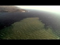
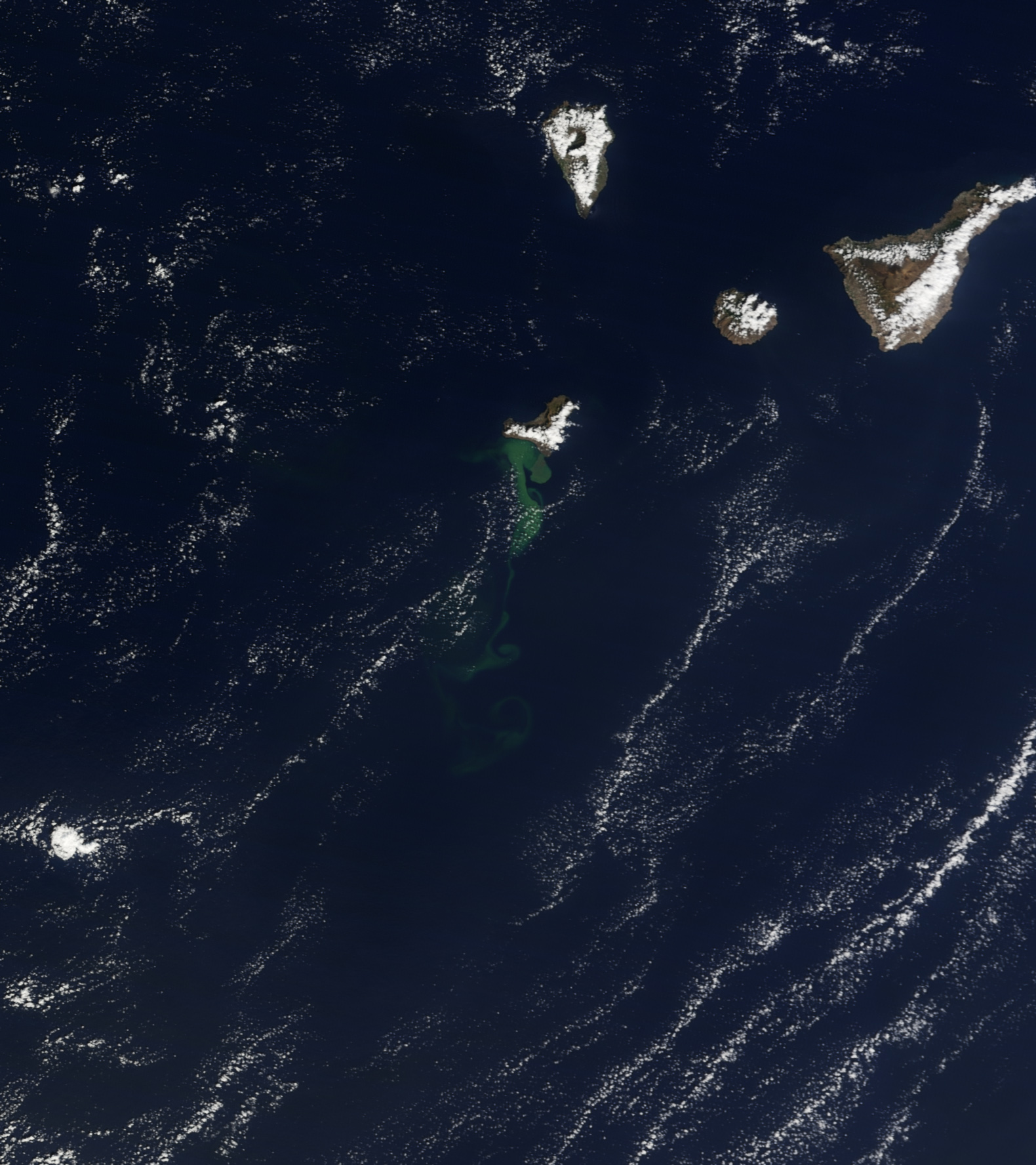
quote:On October 23, 2011, the Moderate Resolution Imaging Spectroradiometer (MODIS) on NASAs Terra satellite captured this natural-color view of El Hierro and the North Atlantic Ocean surrounding it. A milky green plume in the water stretches 25-30 kilometers at its widest and perhaps 100 kilometers long, from a large mass near the coast to thin tendrils as it spread outs to the southwest. The plume is likely a mix of volcanic gases and a blend of crushed pumice and seafloor rock.
<a href="http://goo.gl/q8fhTe" target="_blank">FAQ?</a>
<a href="http://goo.gl/gYvZFq" target="_blank">Geel is een zonnige en vrolijke kleur, als hij tenminste enigszins warm is gekleurd en wat naar het oranje neigt</a>
<a href="http://goo.gl/gYvZFq" target="_blank">Geel is een zonnige en vrolijke kleur, als hij tenminste enigszins warm is gekleurd en wat naar het oranje neigt</a>
best wel ja
[ Bericht 42% gewijzigd door bwt op 27-10-2011 10:40:52 ]


[ Bericht 42% gewijzigd door bwt op 27-10-2011 10:40:52 ]
<a href="http://goo.gl/q8fhTe" target="_blank">FAQ?</a>
<a href="http://goo.gl/gYvZFq" target="_blank">Geel is een zonnige en vrolijke kleur, als hij tenminste enigszins warm is gekleurd en wat naar het oranje neigt</a>
<a href="http://goo.gl/gYvZFq" target="_blank">Geel is een zonnige en vrolijke kleur, als hij tenminste enigszins warm is gekleurd en wat naar het oranje neigt</a>
quote:Scientists now move to El Golfo because of the turbidity of the water in La Restinga
Thursday, October 27, 2011 7:55 acnpress
The research vessel of the Spanish Institute of Oceanography (IEO) Ramón Margalef, Francisco Sanchez, announced the launch, on Thursday, the second phase of research will focus on imaging the coastal area of El Hierro. However, Sanchez said that due to the turbidity of the water in the area of La Restinga will begin by the area of El Golfo and will continue in the current zone of the eruption when the process is restored.
The new data from the scientific campaign being carried out, since last October 23, the Ramon Margalef, on the submarine eruption of El Hierro, will do a better prognosis for the development of submarine eruption, as the member said Wednesday Scientific Committee for Civil Protection Plan for Volcanic Risk Islands (Pevolca), Joan Martí.
Researcher at the Center for Scientific Research (CSIC) and member of the Scientific Committee Pevolca, Joan Martí, the data provided by Ramon Margalef scientific campaign have confirmed that this is a fissure eruption that is located at the intersection of failure with the crack, at a depth of 200 meters, and can "emit about 40 million cubic meters of magma and even something more."
According to Martí's current data and seismic tremor level and above those provided by the scientific campaign, support the conclusion that there is a very low probability of occurrence of an eruption on the ground.
<a href="http://goo.gl/q8fhTe" target="_blank">FAQ?</a>
<a href="http://goo.gl/gYvZFq" target="_blank">Geel is een zonnige en vrolijke kleur, als hij tenminste enigszins warm is gekleurd en wat naar het oranje neigt</a>
<a href="http://goo.gl/gYvZFq" target="_blank">Geel is een zonnige en vrolijke kleur, als hij tenminste enigszins warm is gekleurd en wat naar het oranje neigt</a>
Ik had vanacht gedroomd dat er onder El Hierro een gigantische magmakamer zou zitten en dat het een geluk is dat er voor de kust maar zo'n kleine uitbarsting is 
quote:
Ik had vanacht gedroomd dat er onder El Hierro een gigantische magmakamer zou zitten en dat het een geluk is dat er voor de kust maar zo'n kleine uitbarsting is
misschien heb je een ander bericht ook gelezen en de zaken snachts gemengd?
Zoals deze
Scientists worry about fast inflating new (super)volcano in Bolivia
Nope, eerste keer dat ik dat bericht zie.
Ik denk eerder dat m'n kop iets met die 3d image van alle aarbevingen mee probeerde te doen. De grootte kwam iets meer daarmee over
Ik denk eerder dat m'n kop iets met die 3d image van alle aarbevingen mee probeerde te doen. De grootte kwam iets meer daarmee over
quote:Scientists detect that there is magma beneath El Hierro
The research vessel 'Ramon Margalef' plunge the two robots to take the first real images of cone 100 meters in the sea of las Calmas
CMM Researcher National Geographic Institute (IGN) Joan Martí said yesterday that have proven "very clearly" that magma remains under El Hierro 20 to 25 meters deep and said that the eruption is still ongoing. The researcher was speaking at a press conference within the research vessel Ramón Margalef, robots that immerses today Liropus 2000 and a photogrammetric sled to take the first real images of the eruptive fissure and cone height of 100 meters in Las Calmas.
Marti said that the eruption began in the north and the magma traveled 12 kilometers beneath the island he found out south of La Restinga. The expert noted that "the gas outlet and the seismic signal indicates that the eruption continues," and virtually ruled out a similar eruption in Frontera, where earthquakes are occurring in the last hours, but "continue to monitor." IGN investigator considered "surprising" that the volcano is behaving like a subaerial eruption, despite being underwater.
The two robots that will try today take pictures and videos of the volcano El Hierro from the vessel Ramón Margalef. This was announced by Juan Acosta, a researcher at the Spanish Institute of Oceanography (IEO). Apparently, the turbidity of the water over the mouth of the eruption, the exit of materials, will be difficult to obtain these first real images of the cone, so that scientists plan to begin in El Golfo and gradually get closer the main focus.
The Ministry of Science and Innovation released on Tuesday showed a cartographic approach, in addition to the eruptive fissure, a cone-ups, 100 meters high, with a mouth width of 120 meters, 300 meters deep. "Drawing on the bathymetry (depth map) of this area, conducted in 1998, the Navy Hydrographic Institute and the IEO, we see that in this area I had before was a valley, a valley, where there is now a cone height of 100 meters, "said Acosta.
Joan Martí recommended a new bathymetry within a time to check for changes in morphology of the building. "These structures are very unstable, as they grow, collapse, and will be watched to see what state they are," he said.
Francisco Sanchez of the IEO, added that it is fortunate to have reached a stage where the eruption is not "excessively violent" because it allowed them to pass "just above" the mouth and make the corresponding measurements.
Without oxygen
Joan Martí also revealed that the dead fish may have suffered a shock as it has been found that in the area of the spot had "zero oxygen", which is called anoxia.
quote:El Hierro : Volcano cone has 12 Mln Cu Mt capacity
Scientists from the oceanographic research vessel 'Ramon Margalef' have completed their mapping of the seabed surrounding the volcanic eruption on El Hierro, and are prpearing to deploy their research submarine to relay images of the fissure to the surface for further analysis.
The underwater cone, which was discovered on Monday, has an estimated capacity of 12 Million cubic meters and could produce a volume of 40 Million Cubic Meters of magma, and with a flow of lava over several Km with a volume of 2 Million Cubic Meters - a significant amount given that the eruption only began on the 9th Oct.
The new cone lies some 300 meters below the surface and has a base diameter of 700 meters, a height of 100 meters and with a crater width of about 120 meters. The lava becomes solid once it comes into contact with the cool seawater, forming a crust on the surface, but remaining liquid inside, and moving slowly across the seabed until the inside of the trail eventually cools and solidifies.
The role of the reserach scientists on the surface is to gather the information and relay it to the PEVOLCA commitee and the National Geograhic Institite (IGN).
Further analysis will follow in 3 phases : the remotely operated submarine will take high resolution images of the eruption; a Sled will be used to take further images from different altitudes and angles; and finally, the water / gas colum eminating from the eruption will be analysed. The results of which are expected to be known by early next week.
An interesting post on Youtube this morning (if you have 15 mins to spare ! ) which probably explains why so many North Americans are concerned about the current situation in the Canary Islands (Tumbit Note : Notice that the clips jump between discussing predictions on both El Hierro AND La Palma) >>>


[ Bericht 15% gewijzigd door bwt op 27-10-2011 15:26:39 ]
<a href="http://goo.gl/q8fhTe" target="_blank">FAQ?</a>
<a href="http://goo.gl/gYvZFq" target="_blank">Geel is een zonnige en vrolijke kleur, als hij tenminste enigszins warm is gekleurd en wat naar het oranje neigt</a>
<a href="http://goo.gl/gYvZFq" target="_blank">Geel is een zonnige en vrolijke kleur, als hij tenminste enigszins warm is gekleurd en wat naar het oranje neigt</a>
quote:Hello
Although I have no university degree, i have been educated in the field in 1965 by the great Haroun Tazieff, I started to carry his bag and all I learned was coming from Haroun. I am following volcanoes for more then 45 years and I am now in El Hierro … and I am following day by day the evolution of the seismicity of the volcano island
Earthquake-Report.com wrote earlier:
“Most people in El Hierro were happy to hear that the new crater was finally found and appear to be too happy with the birth of new baby”
But what are they talking about ! … this crater has been around for decades and it is located 3/4 miles south-south-west of La Restinga and rises from a depth of more or less -370 meter. I have given the location of this crater already in an article i wrote on 28/09/2011.
The new crater is located 2 km from the south-west coast of El Hierro at a depth of 150 meters … the water temperature is above 60°C and the Ramon Margalef can unfortunately NOT use his ROV in water at temperatures above 30°C (risk of destruction or important damage) …
The volcano presented by the Ramon Margalef is not the new volcano. The other parts of the picture are not showing signs of an recent eruption … In addition, the new vent culminates at a very shallow depth of 70 m. Contrary to what a lot of people and scientists are telling i have to stress that the Jacuzzi is still working. Also small geysers, stage 2 of an eruption surtseyenne, are appearing …
I am here on the island and i can see this from my viewing point …
Finally, from a volcanic point of view, it is normal that the earthquakes are shifting towards El Julan and El Golfo. Depth close to 20 km, they show that the magma is travelling towards the eruptive vent / fissure … the GPS data and seismograms are in constant evolution n and the ground at El Golfo, El Julan and in the Sea of Las calmas …
quote:A surtseyenne type eruption : What risks to El Hierro?
In addition to the volcanic tremor perpetuates an underwater eruption since 10 October 2011 to 04 17 pm Universal Time, the Instituto Nacional Geográfico - IGN - recorded from October 17 A 01 H 29 Universal Time on October 18, 2011 57 to 00 h Universal Time, 8 new seismic events in the Sea of Las Calma - including 5 in the basal zone eruption in the south-west of La Restinga, and 3 in the West - with a magnitude between 1.5 mbLg and 2.5 and hypocenter ranging between 12 and 30 km focal depth, off the coast of South-East of the island-volcano El Hierro.
On October 17, 2011, following three earthquakes of magnitude greater than 2.0 mbLg:
- The first 07 to 07 h Universal Time, latitude and longitude 27.6873 ° N 18.0374 ° W, 13 km deep hypocenter, magnitude mbLg 2.1;
- The second 55 to 12 h Universal Time, latitude and longitude 27.6645 ° N 18.0448 °, west 16 km deep hypocenter, magnitude mbLg 2.5;
- The third 12 to 18 h Universal Time, latitude and longitude 27.6629 ° N 18.0758 ° W, 18 km deep hypocenter, magnitude mbLg 2.2;
the spectrogram, a major significant change in the volcanic tremor and, consequently, in the eruptive process, has suddenly packed 12 to 19 hours Universal Time.
Two theories can be made:
- A new eruptive vent opened, within the perimeter defined by five seismic hazard cited above, between 150 and 300 meters deep, on the northwest flank of the volcano underwater peaked at 4 / 5 km southwest of La Restinga to -370 meters;
- The volcanic cone of the vent had appeared off the coast of Puerto Naos, 150 meters deep, is close to the ocean level.
In the first case, clear signs, in a few hours, will confirm or deny. But if a new fissure has really opened the first signs that indicate, will be on the one hand, a gradual decrease of volcanic tremor accompanied by a deflation of the ground - no doubt, then, that some scientists interpret it, not as the opening of a new vent, but the underwater volcanic eruption gradually draws to a close, unless a temporary lull, it was nevertheless not be excluded if périclitent volcanic swarms - and, secondly, the gradual disappearance of the hot spot and the resurgence of progressive giant bubbles become less frequent over time.
In the second, the vent was opened to very shallow - 150 meters - the magma flows, pillow lavas forming, it could be no doubt that the volcanic edifice is being built near reaching the surface. Since October 16, giant gas bubbles occur every 15 minutes, overlooking the eruption site. These were the beginnings of a hot spot visible from Puerto Naos and Punta de la Restinga. And high boiling points out that the top part of the new building is sub-flush and the appearance of a plume cyprissoîde, surtseyenne herald an eruption could be imminent.
What risks as part of an eruption surtseyenne?
Surtseyenne type eruption is a type of volcanic eruption that occurs in shallow seas or lakes within 100 meters. It was observed for the first time, Capelinhos, the Azores, from 1957 to 1958, but the emergence of Surtsey, south of Iceland between 1963 and 1967, which gave it its name. These eruptions are eruptions hydromagmatic interacting with violent explosions, more violent than if they occurred on land, caused by andesitic or basaltic magma at a temperature of 1200 ° C, in contact with the shallow water environment or surface water, frequently less than 20 ° C. Water expands and turns into steam, and in contact with the magma, its expansion releases energy that quenches and shatters. It explodes and creates plumes of ash, steam and slag.
The explosive expansion of steam occurs near the surface in an open vent where water pressures and temperatures are relatively low, and where energy can be dispersed during eruptions of variable intensity , repeated at intervals of several minutes that can last many months. Explosions superficial provoquenr collapse of walls at the top of the vent pipe and developing a funnel-shaped
The activity builds hydromagmatic téphraïques surfaces of several square kilometers in the first few months. When the sea water can no longer reach the eruptive vent and lava, the eruption becomes Hawaiian or Strombolian type. The explosions and offshore create plumes of ash and steam that rise to over 4 / 5 kilometers, or 8 to 10 km altitude, and clouds of several hundred meters high of tephra. It results in the formation of tuff rings and pyroclastic cones.
While the surtseyennes eruption generate spectacular explosions that are much less dangerous than leaving to assume their appearance. The coasts of the Atlantic Ocean recellent many cones surtseyens such as Monte Brasil in Terceira, and Monte Guia, Faial, Azores, El Golfo, Lanzarote, and Taco, in Tenerife, Canary Islands ...


<a href="http://goo.gl/q8fhTe" target="_blank">FAQ?</a>
<a href="http://goo.gl/gYvZFq" target="_blank">Geel is een zonnige en vrolijke kleur, als hij tenminste enigszins warm is gekleurd en wat naar het oranje neigt</a>
<a href="http://goo.gl/gYvZFq" target="_blank">Geel is een zonnige en vrolijke kleur, als hij tenminste enigszins warm is gekleurd en wat naar het oranje neigt</a>

quote:27/10/2011 @ 16:36 So far today there have been 26 earthquakes on El Hierro measuring over 1.5° on the Richter scale, two of them have been over 3° at 06:27 and 14:02.
<a href="http://goo.gl/q8fhTe" target="_blank">FAQ?</a>
<a href="http://goo.gl/gYvZFq" target="_blank">Geel is een zonnige en vrolijke kleur, als hij tenminste enigszins warm is gekleurd en wat naar het oranje neigt</a>
<a href="http://goo.gl/gYvZFq" target="_blank">Geel is een zonnige en vrolijke kleur, als hij tenminste enigszins warm is gekleurd en wat naar het oranje neigt</a>

Alle recente bevingen zitten wel erg diep.

<a href="http://goo.gl/q8fhTe" target="_blank">FAQ?</a>
<a href="http://goo.gl/gYvZFq" target="_blank">Geel is een zonnige en vrolijke kleur, als hij tenminste enigszins warm is gekleurd en wat naar het oranje neigt</a>
<a href="http://goo.gl/gYvZFq" target="_blank">Geel is een zonnige en vrolijke kleur, als hij tenminste enigszins warm is gekleurd en wat naar het oranje neigt</a>
quote:28/10/2011 @ 09:19 – New 3D video released by the Ministerio de Ciencia e Innovación showing shape and form of the underwater volcano on El Hierro.
<a href="http://goo.gl/q8fhTe" target="_blank">FAQ?</a>
<a href="http://goo.gl/gYvZFq" target="_blank">Geel is een zonnige en vrolijke kleur, als hij tenminste enigszins warm is gekleurd en wat naar het oranje neigt</a>
<a href="http://goo.gl/gYvZFq" target="_blank">Geel is een zonnige en vrolijke kleur, als hij tenminste enigszins warm is gekleurd en wat naar het oranje neigt</a>


3.3
Bevingen gaan gewoon door.
Zou er echt een uitbartsing zijn/komen in zee boven Frontera?
Nieuwe NASA Foto van El Hierro en andere vulkanen.

[ Bericht 21% gewijzigd door bwt op 28-10-2011 16:50:44 ]
<a href="http://goo.gl/q8fhTe" target="_blank">FAQ?</a>
<a href="http://goo.gl/gYvZFq" target="_blank">Geel is een zonnige en vrolijke kleur, als hij tenminste enigszins warm is gekleurd en wat naar het oranje neigt</a>
<a href="http://goo.gl/gYvZFq" target="_blank">Geel is een zonnige en vrolijke kleur, als hij tenminste enigszins warm is gekleurd en wat naar het oranje neigt</a>
Hier een beter/scherper plaatje dan hierboven
https://twitter.com/#!/teideano/status/130062213326180353
https://twitter.com/#!/teideano/status/130062213326180353
<a href="http://goo.gl/q8fhTe" target="_blank">FAQ?</a>
<a href="http://goo.gl/gYvZFq" target="_blank">Geel is een zonnige en vrolijke kleur, als hij tenminste enigszins warm is gekleurd en wat naar het oranje neigt</a>
<a href="http://goo.gl/gYvZFq" target="_blank">Geel is een zonnige en vrolijke kleur, als hij tenminste enigszins warm is gekleurd en wat naar het oranje neigt</a>
3.6=>
29/10/2011 15:04:48 27.8154 -18.0343 23 III 3.6 4 NW FRONTERA.
Een beste ...
29/10/2011 15:04:48 27.8154 -18.0343 23 III 3.6 4 NW FRONTERA.
Een beste ...
Crazy as Always...met vleugels natuurlijk..;-0
Stevige inderdaad.
Tot nu to vandaag 139 geregistreerde bevingen
Verspreiding aardbevingen laatste 2 dagen.
[ Bericht 31% gewijzigd door bwt op 29-10-2011 19:13:56 ]
Tot nu to vandaag 139 geregistreerde bevingen


Verspreiding aardbevingen laatste 2 dagen.

[ Bericht 31% gewijzigd door bwt op 29-10-2011 19:13:56 ]
<a href="http://goo.gl/q8fhTe" target="_blank">FAQ?</a>
<a href="http://goo.gl/gYvZFq" target="_blank">Geel is een zonnige en vrolijke kleur, als hij tenminste enigszins warm is gekleurd en wat naar het oranje neigt</a>
<a href="http://goo.gl/gYvZFq" target="_blank">Geel is een zonnige en vrolijke kleur, als hij tenminste enigszins warm is gekleurd en wat naar het oranje neigt</a>
hmm.. Ik vlieg later deze week naar Lanzarote. Moet ik me zorgen gaan maken? (ben een geologische leek, dus snap de helft in deze thread niet)
We privileged few, who won the lottery of birth against all odds, how dare we whine at our inevitable return to that prior state from which the vast majority have never stirred?
Lanzarote ligt compleet aan de andere kant van het archipel, je hoeft je echt geen zorgen te maken. Dit is het type lava dat geen (grote) explosies geeft.


<a href="http://goo.gl/q8fhTe" target="_blank">FAQ?</a>
<a href="http://goo.gl/gYvZFq" target="_blank">Geel is een zonnige en vrolijke kleur, als hij tenminste enigszins warm is gekleurd en wat naar het oranje neigt</a>
<a href="http://goo.gl/gYvZFq" target="_blank">Geel is een zonnige en vrolijke kleur, als hij tenminste enigszins warm is gekleurd en wat naar het oranje neigt</a>
quote:El Hierro update : Sat 29th October
Seismic activity on the Island of El Hierro intensified yesterday, with a total of 63 earthquakes being recorded by the National Geographic Institute (IGN), with an average depth of 20km and magnitudes of up to 3.3 on the richter scale, off the North-West coast of the Island.
Of the 63 quakes, 4 were recorded above 3.0, 27 between 2.0 and 3.0 with the remainder being below 2.0.
Over the past week dozens of similar quakes have been recorded in the same area - the opposite side of the Island to where the volcanoi eruption is being observed off the coast of La Restinga.
So far today the IGN has recorded 32 earthquakes, mainly around the El Golfo area, with the largest one being recorded this morning with a 3.3 magnitude.
The movements could indicate a likely change in magma flows deep underground, but scientists are still unable to say if this will result in a change of eruptive phase to the existing underwater volcano, or if a further eruption may occur.
Thel Ramon Margalef Oceanographic research ship is continuing to monitor the situation and has surveyed the underwater eruption off the south coast of the island tocheck for any changes in activity. A new Volcanic crater was discovered earlier this week 300mt below the surface measuring some 100mt high, with a cone diameter of 700mt and a crater width of 120mt. Geologists estimate that it has a cubic capacity of 12 Million Meters and could potentially produce as much as 40 Million cubic meters of magma.
Underwater lave flows have now reached 7km - the magma solidifies on the outside as it comes into contact with the cold seawater, but remains liquid and continues to flow at it's core.

<a href="http://goo.gl/q8fhTe" target="_blank">FAQ?</a>
<a href="http://goo.gl/gYvZFq" target="_blank">Geel is een zonnige en vrolijke kleur, als hij tenminste enigszins warm is gekleurd en wat naar het oranje neigt</a>
<a href="http://goo.gl/gYvZFq" target="_blank">Geel is een zonnige en vrolijke kleur, als hij tenminste enigszins warm is gekleurd en wat naar het oranje neigt</a>
Bevingen concentreren zich wel erg sterk op 1 kleine regio
<a href="http://goo.gl/q8fhTe" target="_blank">FAQ?</a>
<a href="http://goo.gl/gYvZFq" target="_blank">Geel is een zonnige en vrolijke kleur, als hij tenminste enigszins warm is gekleurd en wat naar het oranje neigt</a>
<a href="http://goo.gl/gYvZFq" target="_blank">Geel is een zonnige en vrolijke kleur, als hij tenminste enigszins warm is gekleurd en wat naar het oranje neigt</a>
Important Update 30/10 – 07:53 UTC
- Based on all what follows Earthquake-Report.com predicts that PEVOLCA will meet very soon. Main reason : The increasing strength of the earthquakes.
- The strongest earthquake since October 8 (a M 4.4 quake at the time), now a Magnitude 3.9 quake, occurred at 07:46 this morning in the El Golfo bay. Its epicenter was close to the Frontera coast line. The 4.4 earthquake on October 8 was the start of a number of events like the beginning of harmonic tremor and the start of the green stain (eruption) soon after. The depth is still a secure 22 km. Some scientists are linking however the magma area below the El Golfo to the still continuing eruption to the south of La Restinga. These are however speculations who cannot be proofed.
- At earthquake-report.com we do not consider quakes up to Magnitude 5 as dangerous for houses, although indirect damage can be triggered by rockfall and landslides in mountainous areas like El Hierro. Authorities will certainly follow up the El Hierro landscape scars when the quakes get again to Magnitudes 4 to 5. This will be a major concern for the El Hierro authorities from now on.
- Harmonic tremor remains the same as during recent days. This may change fundamentally if the quakes continue and are getting more powerful.
- Since midnight UTC IGN listed 11 earthquakes and only 2 of them were lower then 2! The last 3 quakes had values of 3.2, 3.9 and 3.0.
- Authorities have closed the Los Roquillos tunnel out of fear of Rockfall for the 3 to 4 magnitude quakes in the beginning of the month and have reopened him last week due to the pressure of the population. Will authorities close the tunnel again ? We do not think that they will take such a decision very soon as technicians have improved some parts of the tunnel. The concern among scientists and PEVOLCA must grow though.
- Joke reported yesterday that the Frontera population reacted completely different to the earthquakes than the El Pinar and La Restinga people. More indifferently and certainly not as alerted as them.
- Those people wanting to follow the discussions among specialized volcano amateur followers can click on this link. We can warmly advise it. A lot of scenarios are being discussed.
http://www.jonfr.com/volcano/?p=1716
Er is idd wat aan het handje daaro in El Hierro. Dussss......wachten op bevestiging.quote:The current tremor data now suggests that a new vent or vents have opened or are about to open up just outside north-west coast of El Hierro volcano. The depth where the main earthquakes have been taking place is about 100 to 300 meters (but might be more). So far the largest earthquakes to take place in this area was a ML3.9 with the depth of 22 km. What is important in this is not the fact that the earthquakes are at great depth. But also the fact that a more shallow might not take place. As that was not the case when the eruption started in El Hierro on 10 October, 2011. It is unlikely that there is going to be any shallow earthquake activity before a new eruption vents opens up. As that was not the case on the 10 October, 2011 from what I can remember.
I am not sure how strong earthquake this area can make. But I am guessing that it might well be in the upper Mb5.5+ range. The earthquakes that are now taking place are due to magma injection. Not a tectonic one. There is a difference between the two. But this rifting in El Hierro might trigger a earthquake close to El Hierro Island in near future, that earthquake would be a tectonic one. Not a earthquake created by magma movements.
So far the new vents are still unconfirmed. But there are signs in the harmonic tremor data that new eruption vents might be opening up or have already opened up. But at this moment I am waiting for a confirmation on this actually taking place. That is going to take a few hours, given the experience so far.
Crazy as Always...met vleugels natuurlijk..;-0

Die was inderdaad langdurig.

<a href="http://goo.gl/q8fhTe" target="_blank">FAQ?</a>
<a href="http://goo.gl/gYvZFq" target="_blank">Geel is een zonnige en vrolijke kleur, als hij tenminste enigszins warm is gekleurd en wat naar het oranje neigt</a>
<a href="http://goo.gl/gYvZFq" target="_blank">Geel is een zonnige en vrolijke kleur, als hij tenminste enigszins warm is gekleurd en wat naar het oranje neigt</a>
Best veel voelbare schokken geweest vandaag.

<a href="http://goo.gl/q8fhTe" target="_blank">FAQ?</a>
<a href="http://goo.gl/gYvZFq" target="_blank">Geel is een zonnige en vrolijke kleur, als hij tenminste enigszins warm is gekleurd en wat naar het oranje neigt</a>
<a href="http://goo.gl/gYvZFq" target="_blank">Geel is een zonnige en vrolijke kleur, als hij tenminste enigszins warm is gekleurd en wat naar het oranje neigt</a>
Idd relatief veel boven de 3 vandaag.
http://www.ign.es/ign/resources/volcanologia/html/energiaHierro.html
En wat te denken van de energietoename?
http://www.ign.es/ign/resources/volcanologia/html/energiaHierro.html
En wat te denken van de energietoename?
SPOILEROm spoilers te kunnen lezen moet je zijn ingelogd. Je moet je daarvoor eerst gratis Registreren. Ook kun je spoilers niet lezen als je een ban hebt.Crazy as Always...met vleugels natuurlijk..;-0
Bevingen blijven erg geconcentreerd net iets uit de kust.
Lijkt zich in iedergeval niet te verplaatsen.
laatste 2 dagen.
Laatste 10 dagen
Lijkt zich in iedergeval niet te verplaatsen.
laatste 2 dagen.
Laatste 10 dagen

<a href="http://goo.gl/q8fhTe" target="_blank">FAQ?</a>
<a href="http://goo.gl/gYvZFq" target="_blank">Geel is een zonnige en vrolijke kleur, als hij tenminste enigszins warm is gekleurd en wat naar het oranje neigt</a>
<a href="http://goo.gl/gYvZFq" target="_blank">Geel is een zonnige en vrolijke kleur, als hij tenminste enigszins warm is gekleurd en wat naar het oranje neigt</a>
quote:October 30, 2011 – CANARY ISLANDS – The National Geographic Institute has confirmed this morning at the direction of the Civil Protection Plan for Volcanic Risk (Pevolca) a magnitude 3.9 earthquake struck northwest of Frontera, located in the sea at a depth of 22 miles deep. The earthquake was followed by a 3.2 magnitude aftershock which struck at a depth of 19 km. The quake, which was felt by the population, occurred at 07.46 hours and is the largest earthquake recorded in the island after the onset of the eruption south of La Restinga. The Emergency Coordination Center and Security (CECOES) received 1-1-2 calls from the towns of Isora, Guarazoca, Mocanal (Valverde) and Tigaday (Border).
The evolution of seismicity in the north of the island has increased in recent days and scientists, who are monitoring constantly all possible scenarios, still cannot ascertain what this new activity means. In this sense, they are inclined to believe that this new activity could be producing a seamount. Moreover, those responsible for the IGN have confirmed that yesterday, 62 earthquakes were reported along this region with two of them being felt by the population. The earthquake of greatest magnitude in yesterday’s swarm reached a magnitude of 3.6 on the Richter scale.
This movement has been located at sea in the Gulf area about 4 miles from the coast at a depth of 23 kilometers. It has been felt by the population with maximum intensity IV in the town of Valverde. The depths vary between 15 km and 25 km. In total, since the day July 17, 2011, the island of El Hierro has been shaken by more than 10, 615 earthquakes. According to reports from scientists at the University of Cadiz, and with reference to the deformation of the ground, this continues in two separate scenarios. The south of the island shows a remission in increasing deformation, clearly marked by the eruption process and that is evident in the data recorded in the GPS station of La Restinga. However, in the north of the island, there is an increased component of deformation component to the North and the East. (Bron
quote:31/10/2011 @ 09:36 – Over the weekend there were 148 earthquakes detected on the Island of El Hierro (from 00:01 on Saturday morning to 23:59 on Sunday night), there were 59 on Saturday, the highest one registered reached 3.6 on the Richter scale and four of these were felt by the population. Yesterday, Sunday 20th October 2011, there were 89 quakes detected, two of which reached a magnitude of 3.9 o nthe Richter scale and 7 of these were felt by the population.
<a href="http://goo.gl/q8fhTe" target="_blank">FAQ?</a>
<a href="http://goo.gl/gYvZFq" target="_blank">Geel is een zonnige en vrolijke kleur, als hij tenminste enigszins warm is gekleurd en wat naar het oranje neigt</a>
<a href="http://goo.gl/gYvZFq" target="_blank">Geel is een zonnige en vrolijke kleur, als hij tenminste enigszins warm is gekleurd en wat naar het oranje neigt</a>
De spikes haal je er al snel uit. veel bevingen.
op de IGN site kun je op de regel met de pieken klikken en dan zie je de stats van dat betreffende uur. erg handig.
op de IGN site kun je op de regel met de pieken klikken en dan zie je de stats van dat betreffende uur. erg handig.

<a href="http://goo.gl/q8fhTe" target="_blank">FAQ?</a>
<a href="http://goo.gl/gYvZFq" target="_blank">Geel is een zonnige en vrolijke kleur, als hij tenminste enigszins warm is gekleurd en wat naar het oranje neigt</a>
<a href="http://goo.gl/gYvZFq" target="_blank">Geel is een zonnige en vrolijke kleur, als hij tenminste enigszins warm is gekleurd en wat naar het oranje neigt</a>
quote:PEVOLVCA Scientists on El Hierro call meeting for this morning
The PEVOLCA Committee on the Island of El Hierro is meeting again this morning to review the current situation on the Island following an increase in seismic activity over the weekend, and to evaluate the information, which has sometimes been conflicting. The Committee took the decision not to take any action yesterday, but instead to wait for a more revue of analysis and meeting today.
The total count of seismic activities is difficult to keep accurate due to their frequencies, however, yesterday there were 93 recorded earthquakes, with a further 41 already being recorded before 09.00 Hrs GMT this morning.
In addition to the frequency of activity, the intensity appears to growing with 2 quakes measuring greater than 2.0 on the richter scale alone this morning.
Doubts have once again been raised about the safety of the Los Roquillos tunnel, which could hinder any attempts to evacuate the residents of the El Golfo area to the main town of Valverde to the North-East of the Island.
More news is expected later in the days once the details discussed in the meeting have been released.
This morning's Youtube clip shows a 3D graphical representation of the seismic activity that has occurred underneath the island between the 10th-30th October

<a href="http://goo.gl/q8fhTe" target="_blank">FAQ?</a>
<a href="http://goo.gl/gYvZFq" target="_blank">Geel is een zonnige en vrolijke kleur, als hij tenminste enigszins warm is gekleurd en wat naar het oranje neigt</a>
<a href="http://goo.gl/gYvZFq" target="_blank">Geel is een zonnige en vrolijke kleur, als hij tenminste enigszins warm is gekleurd en wat naar het oranje neigt</a>
quote:Second eruption imminent
Scientists analysing seismic activity on the Island of El Hierro have warned how a second volcanic eruption could be on the point of happening.
Even though scientists last week spoke of signs of the first eruption off the south coast of the island, decreasing in activity early last week. seismic activity off the opposite coast of the Island led to fears that the eruprion may simply be about to enter a new phase. Over 150 earthquakes were recorded over the course of this weekend around the areas of Frontera and El Golfo, reaching as high as 3.0 on the richter scale.
It is thought that this activity could signal that the magma is now trying to break through to the surface on the opposite side of the island.
No changes to the state of alert have been made - the Island as a whole remains on Yellow alert, with the town of La Restinga, close to the Volcanic eruption on the south coast, remaining on red alert. It has also been rumoured that the El Golfo area may also be moved up to red alert, and the Los Roquillos tunnel closed if earthquakes continue.
A senior Volcanologist, Nemesio Perez, explained to Spain's national broadcaster RTVE "What we do know is that there is activity with magma and this chapter has still not been closed," he said.
The PEVOLCA spokeswoman, Ana Vidal, confirmed the news and referred to the activity as being "great and accelerating."
Although it is a couple of days old now, this Youtube clip shows a good graphical demonstration of what may be happening or about to happen >>
The PEVOLCA committee met this morning to discuss the events of this weekend, but it was found that there is insufficient data to predict what will happen in the coming days, weeks or months.

Nu heeft Mary Greeley de feiten best goed voor elkaar.
Alleen de conclusies die ze er aan verbindt zijn een "klein" beetje overdreven.
Voor de aardbevingen in het zuiden had ze een best stevige uitbarsting voorspeld terwijl het best rustig is gebleven.
In deze video denkt ze dat er heeeeel veel druk opgebouwd wordt en dat deze niet voldoende weg kan in de eruptie in het zuiden. Er zou dus een zware eruptie of zelfs een ontploffing kunnen komen in het noorden van El Hierro. Dat vind ik wel een erg zware uitspraak.
De hoeveelheid bevingen van vandaag tot nu toe (21:04/19:04) : 252quote:31/10/2011 @ 19:29 The El Hierro underwater volcano eruption appears to again be active as magma has been reappearing on the surface of the water off the coast of La Restinga. Residents have said that the sea surface appears much darker.
[ Bericht 5% gewijzigd door bwt op 31-10-2011 21:07:20 ]
<a href="http://goo.gl/q8fhTe" target="_blank">FAQ?</a>
<a href="http://goo.gl/gYvZFq" target="_blank">Geel is een zonnige en vrolijke kleur, als hij tenminste enigszins warm is gekleurd en wat naar het oranje neigt</a>
<a href="http://goo.gl/gYvZFq" target="_blank">Geel is een zonnige en vrolijke kleur, als hij tenminste enigszins warm is gekleurd en wat naar het oranje neigt</a>
Energie opbouw/ontlading sinds 19-7-2011

<a href="http://goo.gl/q8fhTe" target="_blank">FAQ?</a>
<a href="http://goo.gl/gYvZFq" target="_blank">Geel is een zonnige en vrolijke kleur, als hij tenminste enigszins warm is gekleurd en wat naar het oranje neigt</a>
<a href="http://goo.gl/gYvZFq" target="_blank">Geel is een zonnige en vrolijke kleur, als hij tenminste enigszins warm is gekleurd en wat naar het oranje neigt</a>
3.9 zijn er wel meer geweest de laatste dagen.
En dan het wachten op de melding dat er inderdaad een 2e eruptie is.
En dan het wachten op de melding dat er inderdaad een 2e eruptie is.
<a href="http://goo.gl/q8fhTe" target="_blank">FAQ?</a>
<a href="http://goo.gl/gYvZFq" target="_blank">Geel is een zonnige en vrolijke kleur, als hij tenminste enigszins warm is gekleurd en wat naar het oranje neigt</a>
<a href="http://goo.gl/gYvZFq" target="_blank">Geel is een zonnige en vrolijke kleur, als hij tenminste enigszins warm is gekleurd en wat naar het oranje neigt</a>
quote:Data Update 01/11 – 10:37 UTC :
In our 08:19 update we mentioned a stronger harmonic tremor signal being recorded. We have to report that the harmonic tremor became even more stronger the last couple of hours (see below). A very strong harmonic tremor would increase the chance on an eruption considerably. The last earthquake IGN has listed was at 07:18 UTC. It is hard to believe that this list is complete at the moment.


<a href="http://goo.gl/q8fhTe" target="_blank">FAQ?</a>
<a href="http://goo.gl/gYvZFq" target="_blank">Geel is een zonnige en vrolijke kleur, als hij tenminste enigszins warm is gekleurd en wat naar het oranje neigt</a>
<a href="http://goo.gl/gYvZFq" target="_blank">Geel is een zonnige en vrolijke kleur, als hij tenminste enigszins warm is gekleurd en wat naar het oranje neigt</a>
Breaking
quote:Important Update 01/11 – 11:24 UTC
A new El Golfo Helicopter video has been published on you tube. The quality is poor but it looks like a ‘green stain’ eruption has started in the El Golfo bay. More video will have to be conclusive, but as it coincides with the stronger harmonic tremor, it can certainly not be excluded.
We remind our readers that also in the La Restinga / Las Calmas eruption, it started with a green stain only eruption, later followed by the Jacuzzi / Burbuja and thereafter by the grey muddy like stain.
Decisive information will soon come from IGN or CSIS we reckon.

nog een 'flinke' 3.3 in de regio...quote:2011-11-01 12:08:04.0 47min ago 27.78 N 18.06 W 21 3.3 CANARY ISLANDS, SPAIN REGION
Hmm, Vanuit frutsels eerdere video is het volgende te zien links onderin het beeld:
Very Important Update 01/11 – 13:21 UTC
The picture below is courtesy Raymond Matabosch, an amateur volcano follower (presently on the wrong place at El Hierro and speeding to Los Llanillos) who indicates that following him the 3e eruption phase has started in the El Golfo bay, very close to the island. The picture was taken by a passenger of a private airplane.
The picture below has been taken out of a helicopter and precisely what was missing in the video can well be seen here : the grey muddy eruption area.
Raymond, see his history in another update below, expects a number of events within 36 hours.
<a href="http://goo.gl/q8fhTe" target="_blank">FAQ?</a>
<a href="http://goo.gl/gYvZFq" target="_blank">Geel is een zonnige en vrolijke kleur, als hij tenminste enigszins warm is gekleurd en wat naar het oranje neigt</a>
<a href="http://goo.gl/gYvZFq" target="_blank">Geel is een zonnige en vrolijke kleur, als hij tenminste enigszins warm is gekleurd en wat naar het oranje neigt</a>
Update 01/11 – 15:00 UTC
As the time passes by we start to doubt about the video /image eruption outcome as this would be very perceivable from the island itself. We have still no confirmation about this eruption vent. If somebody @ El Golfo is reading this update, please send us a small comment in conforming or denying this information. Unfortunately the webcam looks the other side ! Raymond just told us that the video / picture was taken this morning and that he is almost on the location to be able to see the image area.
On the other hand, Joke Volta just called her friend who lives at Los Llanillos and she said nothing could be seen over there and all was calm. We bring you reports as they develop, even if they afterwards
Even zoeken en lijkt om dit te gaan:
http://www.panoramio.com/photo/3653966

De foto van een eruptie in het noorden van El Hierro bleken dus meer gezichts bedrog dan werkelijkheid.
Maar de onderwater video beelden van de zuidkant zijn echter.
Bezig nachtje geweest.
Meer dan 69 bevingen - meesten tussen de 2 en 3 in magnitude
[ Bericht 16% gewijzigd door bwt op 02-11-2011 08:54:34 ]
Maar de onderwater video beelden van de zuidkant zijn echter.

Bezig nachtje geweest.
Meer dan 69 bevingen - meesten tussen de 2 en 3 in magnitude
[ Bericht 16% gewijzigd door bwt op 02-11-2011 08:54:34 ]
<a href="http://goo.gl/q8fhTe" target="_blank">FAQ?</a>
<a href="http://goo.gl/gYvZFq" target="_blank">Geel is een zonnige en vrolijke kleur, als hij tenminste enigszins warm is gekleurd en wat naar het oranje neigt</a>
<a href="http://goo.gl/gYvZFq" target="_blank">Geel is een zonnige en vrolijke kleur, als hij tenminste enigszins warm is gekleurd en wat naar het oranje neigt</a>
@teideano -> # elhierro tremendous earthquake we just had to start the day.quote:
De foto van een eruptie in het noorden van El Hierro bleken dus meer gezichts bedrog dan werkelijkheid.
Maar de onderwater video beelden van de zuidkant zijn echter.
Bezig nachtje geweest.
Meer dan 69 bevingen - meesten tussen de 2 en 3 in magnitude
Bingo:
1109562 02/11/2011 07:54:55 27.7785 -18.0499 20 Sentido 4.0 4 NW FRONTERA.IHI


[ Bericht 1% gewijzigd door bwt op 02-11-2011 09:20:04 ]
<a href="http://goo.gl/q8fhTe" target="_blank">FAQ?</a>
<a href="http://goo.gl/gYvZFq" target="_blank">Geel is een zonnige en vrolijke kleur, als hij tenminste enigszins warm is gekleurd en wat naar het oranje neigt</a>
<a href="http://goo.gl/gYvZFq" target="_blank">Geel is een zonnige en vrolijke kleur, als hij tenminste enigszins warm is gekleurd en wat naar het oranje neigt</a>
Activiteit lijkt toe te nemen
quote:2011-11-02 07:54:53.0hr 42min ago 28.04 N 17.93 W 10 4.0 CANARY ISLANDS, SPAIN REGION
2011-11-02 07:17:00.51hr 20min ago 27.82 N 18.06 W 21 2.5 CANARY ISLANDS, SPAIN REGION
2011-11-02 06:57:20.01hr 40min ago 27.80 N 18.05 W 21 2.6 CANARY ISLANDS, SPAIN REGION
2011-11-02 06:51:11.31hr 46min ago 27.88 N 18.10 W 15 2.6 CANARY ISLANDS, SPAIN REGION
2011-11-02 06:36:50.82hr 00min ago 27.79 N 18.05 W 19 2.7 CANARY ISLANDS, SPAIN REGION
Die 4.0 was trouwens best langdurig en continue hoge pieken.
De harmonic tremor blijft sterker en sterker worden.
Maar in het onderste deel zo goed als niet. Valt weg in de achtergrond ruis lijkt het.
De zwakkere bevingen tussen 6 en 8 zijn veel duidelijker te herkennen.
[ Bericht 23% gewijzigd door bwt op 02-11-2011 10:24:15 ]

De harmonic tremor blijft sterker en sterker worden.

Die 4.0 beving is op de volgende afbeelding alleen bovenin te zien in de blauwe balk met een spike er in.quote:02/11/2011 @ 08:00 There has been a 4° earthquake detected this morning to the north coast of El Hierro as the government prepare for a new eruption. Additional military personnel and materials such as shelters (for a capacity of 2.000 people) has been sent to the island of El Hierro as experts predict a new eruption on or near the coast of El Hierro after a similar pattern follows the last one. This morning at 07:54 there has been a new earthquake measuring 4° on the Richter scale detected to the north coast of the island. It was felt by the population.
Maar in het onderste deel zo goed als niet. Valt weg in de achtergrond ruis lijkt het.
De zwakkere bevingen tussen 6 en 8 zijn veel duidelijker te herkennen.

[ Bericht 23% gewijzigd door bwt op 02-11-2011 10:24:15 ]
<a href="http://goo.gl/q8fhTe" target="_blank">FAQ?</a>
<a href="http://goo.gl/gYvZFq" target="_blank">Geel is een zonnige en vrolijke kleur, als hij tenminste enigszins warm is gekleurd en wat naar het oranje neigt</a>
<a href="http://goo.gl/gYvZFq" target="_blank">Geel is een zonnige en vrolijke kleur, als hij tenminste enigszins warm is gekleurd en wat naar het oranje neigt</a>
2 erg ondiepe bevingen:
1109582 02/11/2011 08:36:00 27.5986 -17.9594 1 1.9 4 S EL PINAR.IHI
1 KM diep - deze is gecorrigeerd naar 22 KM diep
1109584 02/11/2011 08:37:11 27.9267 -18.1084 3 1.7 4 NW FRONTERA.IHI
3 KM diep - Deze is gecorrigeerd naar 9 KM diep
De onderste en bovenste stip
[ Bericht 16% gewijzigd door bwt op 02-11-2011 13:30:51 ]
1109582 02/11/2011 08:36:00 27.5986 -17.9594 1 1.9 4 S EL PINAR.IHI
1 KM diep - deze is gecorrigeerd naar 22 KM diep
1109584 02/11/2011 08:37:11 27.9267 -18.1084 3 1.7 4 NW FRONTERA.IHI
3 KM diep - Deze is gecorrigeerd naar 9 KM diep
quote:Update 02/11 11:09 UTC :
- IGN had listed 2 shallower earthquakes, 1 at 1 km depth (south of El Pinar) and 1 at 3 km depth nw of Frontera .
- both quakes have been recalculated and revised / deleted (instrumental errors are common in earthquake measuring)

De onderste en bovenste stip
[ Bericht 16% gewijzigd door bwt op 02-11-2011 13:30:51 ]
<a href="http://goo.gl/q8fhTe" target="_blank">FAQ?</a>
<a href="http://goo.gl/gYvZFq" target="_blank">Geel is een zonnige en vrolijke kleur, als hij tenminste enigszins warm is gekleurd en wat naar het oranje neigt</a>
<a href="http://goo.gl/gYvZFq" target="_blank">Geel is een zonnige en vrolijke kleur, als hij tenminste enigszins warm is gekleurd en wat naar het oranje neigt</a>
Wat is in hun ogen het "worst case scenario" ?quote:Evacuation, Shelters and Equipment
The UME (Unidad Militar de Emergencias = Military Emergency group) has announced that it has transported the necessary equipment to El Hierro to build a shelter with a capacity of 2,000 people, in case that a quick evacuation would be needed. The equipment was brought to El Hierro on the request of Pevolca. The shelter will have all necessary compartments like shops (…), dining room and services.
Material to install a shelter to accommodate 500 people and belonging to the Red Cross is already on the island, ready to be used immediately.
PEVOLCA has stressed that the shelter equipment is one of the many measures to be prepared if a worst case scenario would come true.
The shelters have not been installed so far because nobody knows the location where an eruption would be occurring, if it would occur. The most probable spot would be the current eruptive Las Calmas eruption crater as showed on the Ramon Margalef topographic 3-D image below, but the current set of earthquakes are occurring below the El Golfo bay. Pevoca is this prepared for everything.
# ElHierro Pevolca scientists move to Frontera for assessing the seismic situation
quote:The General Directorate of Security and Emergency of the Canarian Government scientists confirmed that Pevolca (Civil Protection Plan for Volcanic Risk) move this morning at El Golfo, Border, El Hierro, was detected after an increase of seismicity in the last hours.
During the visit, assess the situation of eruptive phenomena and the state of neighbors. Throughout the day they decide whether to take further measures of civil protection for citizens.
So far the situation "has not changed" is "quiet," said a regional government spokesman, and no new decisions have been taken because "there are no significant changes or a substantial difference" with respect to previous days.
The National Geographic Institute (IGN) detected at 7:54 pm in the La Frontera an earthquake of magnitude four, according to an initial assessment, which would be the most important seismic crisis detected in this area living on the island of El Iron this summer.
This earthquake was detected at 20 km depth, according to the same source was felt by the population.
Overnight and early morning hours IGN recorded more than 40 earthquakes, although none as important as this morning.
<a href="http://goo.gl/q8fhTe" target="_blank">FAQ?</a>
<a href="http://goo.gl/gYvZFq" target="_blank">Geel is een zonnige en vrolijke kleur, als hij tenminste enigszins warm is gekleurd en wat naar het oranje neigt</a>
<a href="http://goo.gl/gYvZFq" target="_blank">Geel is een zonnige en vrolijke kleur, als hij tenminste enigszins warm is gekleurd en wat naar het oranje neigt</a>
Kwestie van tijd... en dan is de vraag... waar komt de volgende eruptiequote:NVOLCAN confirms an increase in the diffuse emission of CO2 by the volcano of El Hierro.
IGN set the magnitude to 4.3 of the quake at 7:54 pm
http://www.01.ign.es/ign/(...)?evid=1109562&zona=2
http://www.01.ign.es/ign/(...)?evid=1109562&zona=2
<a href="http://goo.gl/q8fhTe" target="_blank">FAQ?</a>
<a href="http://goo.gl/gYvZFq" target="_blank">Geel is een zonnige en vrolijke kleur, als hij tenminste enigszins warm is gekleurd en wat naar het oranje neigt</a>
<a href="http://goo.gl/gYvZFq" target="_blank">Geel is een zonnige en vrolijke kleur, als hij tenminste enigszins warm is gekleurd en wat naar het oranje neigt</a>
*popcorn pakt*
Inorbit: zeg dat dan typluie triangeljosti
Beauregard: Een beetje FOK!ker laat het brood door z'n moeder smeren.
Ecosia
ek's 'n flash drive, jy's 'n floppy
Beauregard: Een beetje FOK!ker laat het brood door z'n moeder smeren.
Ecosia
ek's 'n flash drive, jy's 'n floppy
quote:A professor argues that Barcelona "has underestimated" the Explosive material
The pyroclastic found in waters of La Restinga provide "clear evidence" of an explosive "big" so far "not mentioned publicly by anyone." This is to a report, prepared by Professor of Petrology and Geochemistry, University of Barcelona, Sunday Gimeno, who believes that "it has underestimated the explosive material."
According to The El Hierro Journal contains, the material analyzed,''does not present the characteristics of a surtseyano like eruption, "which is, according to this expert defends the scenario" repeatedly proposed by the scientific monitoring committee.''
In his view, since the surface began to appear in the pyroclasts, the commission "should be understood that it was explosive submarine eruption and a different kind" and that if, moreover, implied magma mixing was "potentially much more dangerous rhyolitic magma involved and if, further, "Gimeno said. Therefore, in its report argues that the pyroclastics," can, and should be analyzed in a matter of hours "for what is being asked the reason for many days "still did not know what they are."
The study of pyroclastic, by the doctor at the request of the City of El Pinar, indicates that magma mixing different compositions is a phenomenon widely reported in the literature as "increasing the explosiveness of magma and, in many cases as a trigger for an explosion, "he explains. Therefore, for this professor of the University of Barcelona, have been mapped throughout a volcanic hypothesis surtseyano" trivializing its potential explosiveness. "
In fact, after Chemical analysis of the material found in the area, notes that, once classified by the TAS diagram (Total-alkali versus silica) of the International Union of Geosciences (IUGS), which is the internationally accepted usage The black product is a basic rock (basanite) and White, a differentiated product (alkaline rhyolite).
The first product was already known in other samples from the island of El Hierro from previous eruptions, while the second is "comparable but not identical, to what is known in other eruptions are less frequent in El Hierro (slightly richer silica), "in the report.
The expert would be advisable to perform a systematic sampling and characterization of pyroclasts that are being expelled by the volcano, as the compositional characteristics and the degree of crystallinity can vary during the eruption and "the evolution of this condition, so this task is useful in the face of crisis management, "he advises.
Also, the professor says in his report that the determination of chemism, which is what can be explained by natural phenomena in accordance with the laws of chemistry, and the degree of crystallinity of the rocks formed during an eruption, "should be done as soon as possible in the course of this, as both factors definitely affect the explosive and therefore the associated volcanic hazard."
Although, according to this expert advocates, many of the Spanish public universities and different centers of the Center for Scientific Research (CSIC) have equipment and technical staff "well qualified", in his opinion, "can not understand how this characterization not carried out since the first time by the commission or commissioning scientific monitoring of the eruption, "he concludes.
<a href="http://goo.gl/q8fhTe" target="_blank">FAQ?</a>
<a href="http://goo.gl/gYvZFq" target="_blank">Geel is een zonnige en vrolijke kleur, als hij tenminste enigszins warm is gekleurd en wat naar het oranje neigt</a>
<a href="http://goo.gl/gYvZFq" target="_blank">Geel is een zonnige en vrolijke kleur, als hij tenminste enigszins warm is gekleurd en wat naar het oranje neigt</a>
*terug gaat naar de winkel en nog een zak haalt*quote:
Inorbit: zeg dat dan typluie triangeljosti
Beauregard: Een beetje FOK!ker laat het brood door z'n moeder smeren.
Ecosia
ek's 'n flash drive, jy's 'n floppy
Beauregard: Een beetje FOK!ker laat het brood door z'n moeder smeren.
Ecosia
ek's 'n flash drive, jy's 'n floppy
Dus als die nu uitbarst word het een hele grote?? Wat moet ik me daarbij voorstellen?? Katla? Krakatau? 
Mijn gok:
Een vergelijkbare uitbarsting als in het zuiden van het eiland. Maar dan dichter bij de kust en een tikkie zwaarder. Ik gok dat we meer borrelend bruin water gaan zien.
Geen grote explosie aangezien het onderwater plaats vind.
Een vergelijkbare uitbarsting als in het zuiden van het eiland. Maar dan dichter bij de kust en een tikkie zwaarder. Ik gok dat we meer borrelend bruin water gaan zien.
Geen grote explosie aangezien het onderwater plaats vind.
<a href="http://goo.gl/q8fhTe" target="_blank">FAQ?</a>
<a href="http://goo.gl/gYvZFq" target="_blank">Geel is een zonnige en vrolijke kleur, als hij tenminste enigszins warm is gekleurd en wat naar het oranje neigt</a>
<a href="http://goo.gl/gYvZFq" target="_blank">Geel is een zonnige en vrolijke kleur, als hij tenminste enigszins warm is gekleurd en wat naar het oranje neigt</a>
Oke dus ik verwachtte er "iets" teveel vanquote:
Mijn gok:
Een vergelijkbare uitbarsting als in het zuiden van het eiland. Maar dan dichter bij de kust en een tikkie zwaarder. Ik gok dat we meer borrelend bruin water gaan zien.
Geen grote explosie aangezien het onderwater plaats vind.
Jaar zonder zomer? Dan moet de Tambora weer rare fratsen gaan uithalenquote:
Dus als die nu uitbarst word het een hele grote??
Katla zit je voor in het verkeerde topic
Wel ben ik benieuwd wat er gebeurd als deze lijn voortzet... gaan de bevingen nog verder noordwaarts, dan zitten we zo bij LaPalma...
Dat zal wel mee vallen als ik zo kijk naar de ligging van de eilanden en de breuklijnen her en der.

<a href="http://goo.gl/q8fhTe" target="_blank">FAQ?</a>
<a href="http://goo.gl/gYvZFq" target="_blank">Geel is een zonnige en vrolijke kleur, als hij tenminste enigszins warm is gekleurd en wat naar het oranje neigt</a>
<a href="http://goo.gl/gYvZFq" target="_blank">Geel is een zonnige en vrolijke kleur, als hij tenminste enigszins warm is gekleurd en wat naar het oranje neigt</a>
Het is een beetje onrustig aan het worden. Niet alle spikes worden aangegeven als beving. Bijvoorbeeld de spike in het midden (van 14-15) wordt aangegeven als een beving van 2.3 nét ervoor. Zijn het nog bevingen, of zijn het kortstondige oplevingen in activiteit die niet als beving geregistreerd worden?:
14:29:46 27.7926 -18.0645 21 2.3 4 NW FRONTERA.IHI
(tussen 14-15)
(15-16 laat een nog grotere spike zien die (vooralsnog) niet als beving is geregistreerd)
14:29:46 27.7926 -18.0645 21 2.3 4 NW FRONTERA.IHI
(tussen 14-15)

(15-16 laat een nog grotere spike zien die (vooralsnog) niet als beving is geregistreerd)

Daar zat ik me eerder ook al over te brainstormen.
Maar kon geen echte reden vinden om het te posten.
(hoe kom je trouwens bij deze plaatjes?)
Maar kon geen echte reden vinden om het te posten.
(hoe kom je trouwens bij deze plaatjes?)
<a href="http://goo.gl/q8fhTe" target="_blank">FAQ?</a>
<a href="http://goo.gl/gYvZFq" target="_blank">Geel is een zonnige en vrolijke kleur, als hij tenminste enigszins warm is gekleurd en wat naar het oranje neigt</a>
<a href="http://goo.gl/gYvZFq" target="_blank">Geel is een zonnige en vrolijke kleur, als hij tenminste enigszins warm is gekleurd en wat naar het oranje neigt</a>
Als je op de lijnen klikt kan je per uur zien wat er gebeurt, dat was al bekend. Maar daarna kan je rechts ook voor de andere weergave kiezenquote:
Daar zat ik me eerder ook al over te brainstormen.
Maar kon geen echte reden vinden om het te posten.
(hoe kom je trouwens bij deze plaatjes?)

<a href="http://goo.gl/q8fhTe" target="_blank">FAQ?</a>
<a href="http://goo.gl/gYvZFq" target="_blank">Geel is een zonnige en vrolijke kleur, als hij tenminste enigszins warm is gekleurd en wat naar het oranje neigt</a>
<a href="http://goo.gl/gYvZFq" target="_blank">Geel is een zonnige en vrolijke kleur, als hij tenminste enigszins warm is gekleurd en wat naar het oranje neigt</a>
Jezus, dat zijn bevingen waar een normale vulkaan gewoon gaat ploffenquote:
En een 4.4
1109738 02/11/2011 18:10:39 27.7891 -18.0602 23 III 4.4 4 NW FRONTERA.IHI
[ afbeelding ]
Zeker met dit soort trillingen......
Die lijn (zwarte) zwiept gewoon zwaar heen en weer. Onderste punten tot onder de 45 minuten lijn.
De basis lijn is die van 9 tot 12 minuten
Wat een intensiteit zeg.....
: S Is it the greatest? RT @ onalita2011: If no further adjustments of 3.8 for the 18:10 hrs. goes to 4.4. I felt it and it was amazing.
@bimbacha - Chiara Cabrera is inwoonster op El Hierro
[ Bericht 17% gewijzigd door bwt op 02-11-2011 20:20:13 ]
Die lijn (zwarte) zwiept gewoon zwaar heen en weer. Onderste punten tot onder de 45 minuten lijn.
De basis lijn is die van 9 tot 12 minuten

Wat een intensiteit zeg.....

: S Is it the greatest? RT @ onalita2011: If no further adjustments of 3.8 for the 18:10 hrs. goes to 4.4. I felt it and it was amazing.
@bimbacha - Chiara Cabrera is inwoonster op El Hierro
[ Bericht 17% gewijzigd door bwt op 02-11-2011 20:20:13 ]
<a href="http://goo.gl/q8fhTe" target="_blank">FAQ?</a>
<a href="http://goo.gl/gYvZFq" target="_blank">Geel is een zonnige en vrolijke kleur, als hij tenminste enigszins warm is gekleurd en wat naar het oranje neigt</a>
<a href="http://goo.gl/gYvZFq" target="_blank">Geel is een zonnige en vrolijke kleur, als hij tenminste enigszins warm is gekleurd en wat naar het oranje neigt</a>
Weet iemand wat teideano nu op Twitter roept? Tis spaans en zit op toon dus kennie vertalen.....
Alexa en Seth zijn lief
See everything; overlook a great deal; correct a little
See everything; overlook a great deal; correct a little
quote:
Weet iemand wat teideano nu op Twitter roept? Tis spaans en zit op toon dus kennie vertalen.....
quote:en weer ..... nog een goede maar goed wiebelen.
precies
Maar nog geen data van IGN
Ben benieuwd
Maar nu eerst toch pitten
is denk ik geen net wel/ geen 3 geweest
Maar nog geen data van IGN
Ben benieuwd
Maar nu eerst toch pitten

is denk ik geen net wel/ geen 3 geweest
<a href="http://goo.gl/q8fhTe" target="_blank">FAQ?</a>
<a href="http://goo.gl/gYvZFq" target="_blank">Geel is een zonnige en vrolijke kleur, als hij tenminste enigszins warm is gekleurd en wat naar het oranje neigt</a>
<a href="http://goo.gl/gYvZFq" target="_blank">Geel is een zonnige en vrolijke kleur, als hij tenminste enigszins warm is gekleurd en wat naar het oranje neigt</a>
| Forum Opties | |
|---|---|
| Forumhop: | |
| Hop naar: | |