WKN Weer, Klimaat en Natuurrampen
Lees alles over het onstuimige weer op onze planeet, volg orkanen en tornado's, zie hoe vulkanen uitbarsten en hoe Moeder Aarde beeft bij een aardbeving. Alles over de verwoestende kracht van onze planeet en tal van andere natuurverschijnselen.


quote:El Hierro : Tunnel reopens but red alert remains
The evacuated residents of La Restinga on the island of El Hierro will be allowed to return to their properties as from from 08:00 on Friday due to the decrease of seismic activity. However, the authorities will maintain surveillance 24 hours a day in the likelihood of activity returning and a further evacuation being necessarry. The Los Roquille tunnel will open between the hours of 08.00 ro 20.00.
For the time being schoolchildren have been moved from the village to study at the town of El Pinar closeby.
The Los Roquille tunnel will only be open during daylight hours to begin with, however it may be permitted to open throughout the night depending upon the developments over the coming days.
With regards to the evacuations at La Frontera, a technical committee comprising of teh El Hierro local council, The Canary Islands Regional Government and the Geological and Mining Institute of Spain (IGME) have assessed the situation and are due to inform the owners if they may return to their homes.
PEVOLCA also confirmed that the state of alert remains as 'red', and that this is likely to remain the case until data suggests that the eruptions are over.
quote:El Hierro Coast to be Declared Area of Special Protection
The las Calmas area off the South-West coast of the Island of el Hierro, is to be designated an area of special Protection (SPA) by Ministerial order, after being affected by pollution from the stain created by the volcanic eruption over the last week.
SPA's are regarded as being under the protection of the crown, and intended to promote the conservation of migratory bird species, according to the draft that is available to the public by the Ministry of Environment, Rural and Marine Affairs .
The news SPA in the las Calmas area may not have affected the birds that nest on the ground, as they will look for food in deeper waters and not close to the coast, which is where the majority of the pollution has drifted, according to Antonio Lorenzo, from Tenerife SEO / BirdLife .
The ministerial order to comply with Law 42/2007 for Natural Heritage and Biodiversity . And the identification of SPA's comes "from an intense scientific work and earlier research." However, further research may result in new areas designated for the smae protection.
The new SPA will join the marine Natura 2000 network in Spain, a European system of biodiversity conservation.
quote:El Hierro : The Conspiracy Theories Keep Coming
It has become an impossibility to keep count of all of the activity in the recent earthquake swarm on the island of El Hierro, with latest estimates place the tally somewhere around 10'800 since activity first began back in July.
Indeed, the media's focus seems to have shifted from the frequency and intensity of the seismic activity going on underneath the island - which is still happening - to the progression of the eruptive phases of the underwater volcano, which, if what Scientists are telling us is to be believed, seems to be on the wane.
One thing, however, that does seem to be on the increase is the amount of conspiracy theories being floated on a number of forums and social networks on the web.
Accusations are abound of scientists and politicians deliberately manipulating analytical data in order not to panic the residents of the island in light of a further enormous Earthquake / Volcano / Tsunami / Elvis landing on the Island on a UFO (* delete as appropriate).
Perhaps the most popular conspiracy theory doing the rounds is that of the entire eastern seaboard of the USA being just hours away from disaster with a massive earthquake / Volcanic eruption causing a 300 ft tidal wave. Although the theory is not a new one by any means, with its likelihood being documented on the BBC Horizon program in the 1990's, there were 2 key points that need to be considered before our friends across the pond go in search of higher ground :
1. The documentary discussed the probability of an event that was though to have happened some 50'000 years ago, when an enormous landslide fell away from the North side of the island of El Hierro, accusing a Tsunami that has been widely thought to have been responsible for the creating of the Florida Everglades. Comparing the Island's Geology of 50'000 years ago to today seems obsolete.
2. The Documentary predicted what would happen in the event of the Caldera de Tabauriente, on the neighbouring Island of la Palma suffering a similar fate. Whilst it is generally agreed that any similar activity would cause an enormous landslide resulting in a 'Super-tsunami', which would be expected to cause the worst natural disaster that history has ever recorded, it needs to be remembered that A) La Palma is not El Hierro, and that B) There have been no confirmed reports of seismic activity on La Palma.
If you have 5 Minutes to spare, have a look at our favourite scaremongering conspiracy theory on Youtube (above).
Whilst being particularly fond of style guru Prof Simon Day, Tumbit blames the Illuminati.
<a href="http://goo.gl/q8fhTe" target="_blank">FAQ?</a>
<a href="http://goo.gl/gYvZFq" target="_blank">Geel is een zonnige en vrolijke kleur, als hij tenminste enigszins warm is gekleurd en wat naar het oranje neigt</a>
<a href="http://goo.gl/gYvZFq" target="_blank">Geel is een zonnige en vrolijke kleur, als hij tenminste enigszins warm is gekleurd en wat naar het oranje neigt</a>
http://www.01.ign.es/ign/head/volcaSenalesAnterioresDia.do?nombreFichero=EOSO_2011-10-21&ver=s&estacion=EOSO&Anio=2011&Mes=10&Dia=21&tipo=1
Check seismische activiteit Gran Canaria 21-10-2011...(en Fuerteventura, Lanzarote,Tenerife, LaGomera ook). En nog steeds La Palma 'out of seismische reach'.
Check seismische activiteit Gran Canaria 21-10-2011...(en Fuerteventura, Lanzarote,Tenerife, LaGomera ook). En nog steeds La Palma 'out of seismische reach'.
Crazy as Always...met vleugels natuurlijk..;-0
Dat is de schokgolf van de 7,9 aardbeving. Over heel de wereld is die terug te vinden. Het rare is, bij EL Hierro niet!quote:Op zaterdag 22 oktober 2011 00:45 schreef zenkelly het volgende:
http://www.01.ign.es/ign/head/volcaSenalesAnterioresDia.do?nombreFichero=EOSO_2011-10-21&ver=s&estacion=EOSO&Anio=2011&Mes=10&Dia=21&tipo=1
Check seismische activiteit Gran Canaria 21-10-2011...(en Fuerteventura, Lanzarote,Tenerife, LaGomera ook). En nog steeds La Palma 'out of seismische reach'.
http://img695.imageshack.us/img695/6429/nieactive.gif (copy/paste deze link)
http://aslwww.cr.usgs.gov/Seismic_Data/heli2_us.shtml
Hier is hij ook terug te zien op veel plaatsen in Amerika.
Hier is hij ook terug te zien op veel plaatsen in Amerika.
Update 22/10 – 07:58 UTC – Overview of the last 14 hours
- The Ramon Margelef, the oceanographic ship with the ROV aboard has been detected in Tenerife this morning by one of our readers. We expect that the ship will extend his crew with scientists and load additional fuel and equipment to set sail for El Hierro later today.
- The number of volcanic earthquakes has been rising since the Sea Jacuzzi stopped working. Yesterday IGN recorded a total of 31 earthquakes varying in depth from 25.7 km to 10.6 km. Magnitudes reached a max. of 2.6.
The first 8 hours of today (the list is not complete as of yet) we noticed 13 earthquakes (max. 2.3). It looks like we are heading to the pre-eruptive state
- Volcano followers are suggesting that IGN and/or CSIC to call in IMO Iceland volcanologist(s), who are highly specialized in this kind of eruptions. If the El Hierro volcano would erupt, the chance that it will be a Surtseyan eruption is high. Surtsey was one of the first well monitored volcano build islands which rose out of the ocean from 1963 to 1967.
- 20 people of La Restinga have chosen to stay in the Student home of Valverde because they do not trust the situation in La Restinga
- Diving companies have made some dives yesterday in the northern part of the island. We hope that the water is continuously tested on Ph degree because the water currents are driving the green stain to other parts of the island.
- 2 restaurants have reopened their doors in La Restinga. Tomorrow the supermarket will reopen too. It will be the first time in a long period that they will not be able to sell fish from the local fisherman.
- people are depressed in seeing the dead fish floating on the water. They fear that one of the main income streams for the local people, the Sea, will be shut down for an unterminated period. Some said if the volcano would have grown above the water, we would have attracted a lot of tourists now we are left with nothing and an eco-disaster on top.
- people in the street continue to have lively discussions about the truth of the eruption. As nothing can be seen with their own eyes, they have to choose for one of the many different opinions of politicians and scientists on what is happening.
[ Bericht 35% gewijzigd door stan12 op 22-10-2011 10:53:57 ]
Update 22/10 – 08:46 UTC: - We have noticed a sudden change in frequency since about an hour. Click here to see what we try to explain. The yellow and red colored zones have changed. We do not know the reason yet, but some (probably minor) change is going on below the volcano (but very deep and without danger to the population or their belongings). Similar changes have occurred during the recent days, mostly resulting in less activity soon after.
http://www.01.ign.es/ign/(...)es=10&Dia=22&tipo=2#
http://www.01.ign.es/ign/(...)es=10&Dia=22&tipo=2#
THNX!!quote:
[..]
Dat is de schokgolf van de 7,9 aardbeving. Over heel de wereld is die terug te vinden. Het rare is, bij EL Hierro niet!
[ http://img695.imageshack.us/img695/6429/nieactive.gif (copy/paste deze link) ]
Crazy as Always...met vleugels natuurlijk..;-0
Ik ben ff niet aanwezig en lees iets over een 7.9?quote:
[..]
Dat is de schokgolf van de 7,9 aardbeving. Over heel de wereld is die terug te vinden. Het rare is, bij EL Hierro niet!
[ http://img695.imageshack.us/img695/6429/nieactive.gif (copy/paste deze link) ]
Waar?
<a href="http://goo.gl/q8fhTe" target="_blank">FAQ?</a>
<a href="http://goo.gl/gYvZFq" target="_blank">Geel is een zonnige en vrolijke kleur, als hij tenminste enigszins warm is gekleurd en wat naar het oranje neigt</a>
<a href="http://goo.gl/gYvZFq" target="_blank">Geel is een zonnige en vrolijke kleur, als hij tenminste enigszins warm is gekleurd en wat naar het oranje neigt</a>
Aardbevingen #13quote:
[..]
Ik ben ff niet aanwezig en lees iets over een 7.9?
Waar?
Als het niet met een hamer te repareren is, is het een elektrisch probleem.
quote:Further earthquakes and volcanic activity returns to El Hierro
The volcanic activity on the island of El Hierro has shown new signs of activity this morning, with bubbles on the surface of the ocean changing in colour.
Last night scientists also recorded around 50 new earthquakes between 24 and 16 miles deep, and with a magnitude of between 2 and 2.6 on the richter scale.
Bubbles have returned to the surface of the Las Calmas bay after appearing to decrease on Friday, with a change to their colour which may indicate a different phase in the eruptive activity. The Security General Directorate has decided that the Emergency and Rescue Group have made a number of inspection flights over the island, but are yet to make any official statement to confrm their opinion.
Earlier thsi morning the Ramon Margalef research ship from the Spanish Institute of Oceanography arrived at the island in order to take samples from the Las Calmas area and to analyse changes in the underwater volcanic activity.
Whilst the residents of the town of El Hierro are anxious that an further evacuatuion may be forced upon them, Scientists report that changes such as reported ar quite normal and to be expected in activity such as this.
<a href="http://goo.gl/q8fhTe" target="_blank">FAQ?</a>
<a href="http://goo.gl/gYvZFq" target="_blank">Geel is een zonnige en vrolijke kleur, als hij tenminste enigszins warm is gekleurd en wat naar het oranje neigt</a>
<a href="http://goo.gl/gYvZFq" target="_blank">Geel is een zonnige en vrolijke kleur, als hij tenminste enigszins warm is gekleurd en wat naar het oranje neigt</a>
Aerial surveys conducted this morning on the Sea of Calm
Aerial reconnaissance Helicopter Emergency and Rescue Group (GES) of the Canary Islands, held this morning on the Sea of Calm, has been able to specify the nature of changes in the spot, visible in the early hours from La Restinga. The appearance of the stain is due to the presence of magmatic material, concentrated in certain areas.
Date: October 23, 2011
Location: La Restinga (El Hierro)
Credit: Government of the Canary Islands
<a href="http://goo.gl/q8fhTe" target="_blank">FAQ?</a>
<a href="http://goo.gl/gYvZFq" target="_blank">Geel is een zonnige en vrolijke kleur, als hij tenminste enigszins warm is gekleurd en wat naar het oranje neigt</a>
<a href="http://goo.gl/gYvZFq" target="_blank">Geel is een zonnige en vrolijke kleur, als hij tenminste enigszins warm is gekleurd en wat naar het oranje neigt</a>
Twitter bericht
# VOLCANO # ELHIERRO The last hours, 78 seismic events and a sensible. Most 3.1, a maximum magnitude in El Golfo. via @ PrensaElHierro
# VOLCANO # ELHIERRO The last hours, 78 seismic events and a sensible. Most 3.1, a maximum magnitude in El Golfo. via @ PrensaElHierro
<a href="http://goo.gl/q8fhTe" target="_blank">FAQ?</a>
<a href="http://goo.gl/gYvZFq" target="_blank">Geel is een zonnige en vrolijke kleur, als hij tenminste enigszins warm is gekleurd en wat naar het oranje neigt</a>
<a href="http://goo.gl/gYvZFq" target="_blank">Geel is een zonnige en vrolijke kleur, als hij tenminste enigszins warm is gekleurd en wat naar het oranje neigt</a>
Ben benieuwd of dit doorzet en dat weer meer en meer onrustzien ten noorden van El Hierro.quote:[url=http://theextinctionprotocol.wordpress.com/2011/10/23/swarm-of-tremors-reported-on-north-side-of-el-hierro/]Earthquake tremors north of island[/url
October 23, 2011 – CANARY ISLANDS – A large swarm of more than 41 tremors have been reported taking place today in the ocean on the north side of El Hierro. The tremors are happening off the coast of NW Frontera and are an indication that magmatic pressures have moved across the island.
SPOILEROm spoilers te kunnen lezen moet je zijn ingelogd. Je moet je daarvoor eerst gratis Registreren. Ook kun je spoilers niet lezen als je een ban hebt.
[ Bericht 0% gewijzigd door Frutsel op 25-10-2011 13:53:23 ]

<a href="http://goo.gl/q8fhTe" target="_blank">FAQ?</a>
<a href="http://goo.gl/gYvZFq" target="_blank">Geel is een zonnige en vrolijke kleur, als hij tenminste enigszins warm is gekleurd en wat naar het oranje neigt</a>
<a href="http://goo.gl/gYvZFq" target="_blank">Geel is een zonnige en vrolijke kleur, als hij tenminste enigszins warm is gekleurd en wat naar het oranje neigt</a>
quote:New magma intrusion into El Hierro volcano, Canary Islands, Spain
Few days ago a new magma intrusion did start in El Hierro volcano, Canary Islands, Spain. But this means that the pressure is increasing inside El Hierro current magma still. The new magma is going the same path as before, and is forming a new sill north-west part of El Hierro volcano. It seems that this magma has not yet encountered the magma that is already inside El Hierro volcano. What happens when the new magma encounters the slightly older magma is a open question. But I am sure what happens is going to be interesting and is going to create a new eruption vent in my opinion.
The new magma intrusion in El Hierro. It is not yet in contact with the existing magma in El Hierro. It is hard to know exactly what happens when the new magma gets into contact with the magma that is already in El Hierro. Copyright of this picture belongs to Instituto Geográfico Nacional.
What is really interesting about this new magma is that this seems to be a new intrusion from a new conduct below El Hierro. This conduct does not appear in the earthquakes that started in July 2011 to today. There is a great risk that more new conducts are going to open up under El Hierro in this same manner. But this means that new magma can start to flow into El Hierro at new point under El Hierro. But that is always marked by a increase in earthquake activity where a new magma intrusion starts in El Hierro. This new magma intrusion into El Hierro appears to be rather small at the moment. But it is most likely going to grow over the next few weeks.
De onderwater activiteit verplaatst zich:

<a href="http://goo.gl/q8fhTe" target="_blank">FAQ?</a>
<a href="http://goo.gl/gYvZFq" target="_blank">Geel is een zonnige en vrolijke kleur, als hij tenminste enigszins warm is gekleurd en wat naar het oranje neigt</a>
<a href="http://goo.gl/gYvZFq" target="_blank">Geel is een zonnige en vrolijke kleur, als hij tenminste enigszins warm is gekleurd en wat naar het oranje neigt</a>
Digital terrain model for an overview of the Rift south of El Hierro. From the crater and SW direction shows the crack in which effusive activity has been detected. The volcano is located on the western flank of the South Rift of El Hierro. Image obtained by the scientific team of the Spanish Institute of Oceanography (IEO) on board the Ramon Margalef. 25/10/11 ACN Press. (Figures released by the Ministry of Science and Innovation)
plaatje - De nieuwe uitbarsting is dus onder La Restinga op de westelijke "berg keten" onder water.
Op bovenstaande plaatje (vorige post) kun je dus zien dat de uitbarstings gassen in noordelijke richting "drijven" en daarna door de atlantische stroming naar het zuiden afdrijven.
plaatje - De nieuwe uitbarsting is dus onder La Restinga op de westelijke "berg keten" onder water.
Op bovenstaande plaatje (vorige post) kun je dus zien dat de uitbarstings gassen in noordelijke richting "drijven" en daarna door de atlantische stroming naar het zuiden afdrijven.
quote:VALVERDE (EL HIERRO), 25 Oct. (EUROPA PRESS) -
A team of scientists from the Spanish Institute of Oceanography (IEO), public research body under the Ministry of Science and Innovation, has been located and mapped the outbreaks of the eruption of underwater volcano in El Hierro during the scientific mission from the past 23 October, being developed in the area on board the ship Ramon Margalef.
The scientific team, led by Juan Acosta and Francisco Sanchez, has located a newly created volcano cone-shaped, with a base diameter of 700 meters, a height of 100 meters and a crater about 120 meters wide. The base of the crater is located 300 meters deep. Also, using higher frequency echosounders has been possible to locate the columns of gases and fluids emitted by the volcano and other emission points (cracks).
The authors emphasize that the finding is the first to be achieved in these conditions throughout the world, has been investigated since the volcano and associated volcanic activity in the optimal timing of eruptive activity on the merits. This early localization and characterization of volcanic phenomenon will study the temporal evolution of these phenomena and facilitate the interpretation and understanding of volcanic phenomena on the islands.
SHIP FIRST SCIENTIFIC MISSION
Ramon Margalef The ship departed from Vigo on Tuesday October 18 en route to Tenerife, where he arrived on Saturday. On Sunday morning finally came to El Hierro. The Ramon Margalef, until a few weeks ago still in the testing phase, accelerated its set-up to lead this scientific mission, which involves its release. Its aim is to study volcanic activity in the area and its consequences in the seabed of the Canary Islands and in its ecosystem.
The ship is carrying a remote monitoring underwater vehicle called Liropus, able to observe and ecosystems sample up to 2,000 meters deep.
The oceanographic campaign in which these discoveries have been made in collaboration with the Canary Islands Oceanic Platform (Plocan) and the Canarian Agency for Research, Innovation and Information Society (ACIISI), under support of the Scientific Committee Pevolca.
<a href="http://goo.gl/q8fhTe" target="_blank">FAQ?</a>
<a href="http://goo.gl/gYvZFq" target="_blank">Geel is een zonnige en vrolijke kleur, als hij tenminste enigszins warm is gekleurd en wat naar het oranje neigt</a>
<a href="http://goo.gl/gYvZFq" target="_blank">Geel is een zonnige en vrolijke kleur, als hij tenminste enigszins warm is gekleurd en wat naar het oranje neigt</a>
Update 25/10 – 15:18 UTC : The image doesn’t look very spectacular but the findings are. The base diameter of the new volcano shape (as they call it) is 700 meters. It has a present height of 100 meter and a crater of 120 meter. The base of the crater is measured at a depth of 300 meter.
We congratulate the crew from the Ramon Margalef with these great findings.
We congratulate the crew from the Ramon Margalef with these great findings.

Beelden van NASA over El Hierro

<a href="http://goo.gl/q8fhTe" target="_blank">FAQ?</a>
<a href="http://goo.gl/gYvZFq" target="_blank">Geel is een zonnige en vrolijke kleur, als hij tenminste enigszins warm is gekleurd en wat naar het oranje neigt</a>
<a href="http://goo.gl/gYvZFq" target="_blank">Geel is een zonnige en vrolijke kleur, als hij tenminste enigszins warm is gekleurd en wat naar het oranje neigt</a>
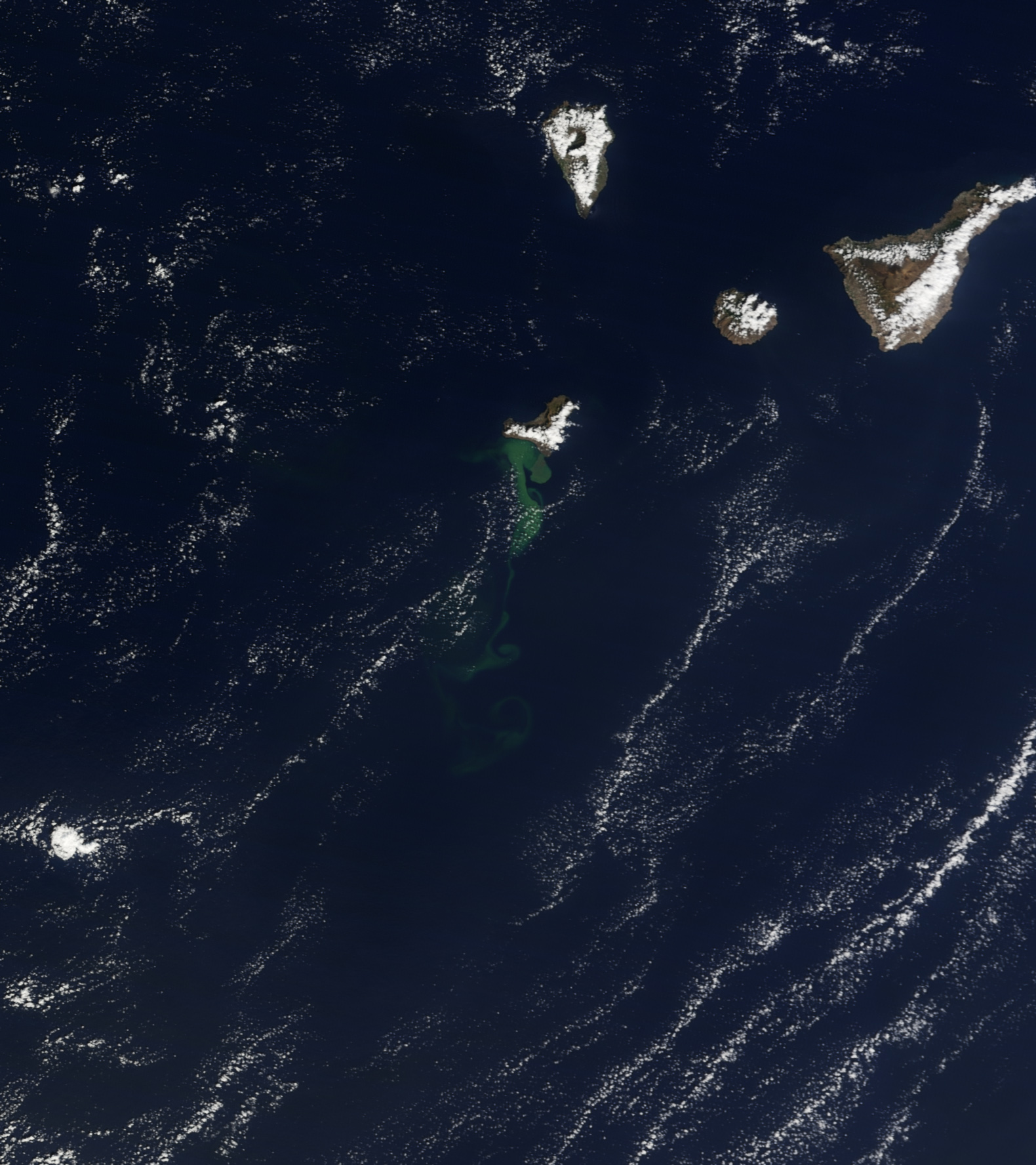
Opnieuw NASA met foto en verhaal
quote:On October 23, 2011, the Moderate Resolution Imaging Spectroradiometer (MODIS) on NASAs Terra satellite captured this natural-color view of El Hierro and the North Atlantic Ocean surrounding it. A milky green plume in the water stretches 25-30 kilometers at its widest and perhaps 100 kilometers long, from a large mass near the coast to thin tendrils as it spread outs to the southwest. The plume is likely a mix of volcanic gases and a blend of crushed pumice and seafloor rock.
<a href="http://goo.gl/q8fhTe" target="_blank">FAQ?</a>
<a href="http://goo.gl/gYvZFq" target="_blank">Geel is een zonnige en vrolijke kleur, als hij tenminste enigszins warm is gekleurd en wat naar het oranje neigt</a>
<a href="http://goo.gl/gYvZFq" target="_blank">Geel is een zonnige en vrolijke kleur, als hij tenminste enigszins warm is gekleurd en wat naar het oranje neigt</a>
best wel ja
[ Bericht 42% gewijzigd door bwt op 27-10-2011 10:40:52 ]


[ Bericht 42% gewijzigd door bwt op 27-10-2011 10:40:52 ]
<a href="http://goo.gl/q8fhTe" target="_blank">FAQ?</a>
<a href="http://goo.gl/gYvZFq" target="_blank">Geel is een zonnige en vrolijke kleur, als hij tenminste enigszins warm is gekleurd en wat naar het oranje neigt</a>
<a href="http://goo.gl/gYvZFq" target="_blank">Geel is een zonnige en vrolijke kleur, als hij tenminste enigszins warm is gekleurd en wat naar het oranje neigt</a>
quote:Scientists now move to El Golfo because of the turbidity of the water in La Restinga
Thursday, October 27, 2011 7:55 acnpress
The research vessel of the Spanish Institute of Oceanography (IEO) Ramón Margalef, Francisco Sanchez, announced the launch, on Thursday, the second phase of research will focus on imaging the coastal area of El Hierro. However, Sanchez said that due to the turbidity of the water in the area of La Restinga will begin by the area of El Golfo and will continue in the current zone of the eruption when the process is restored.
The new data from the scientific campaign being carried out, since last October 23, the Ramon Margalef, on the submarine eruption of El Hierro, will do a better prognosis for the development of submarine eruption, as the member said Wednesday Scientific Committee for Civil Protection Plan for Volcanic Risk Islands (Pevolca), Joan Martí.
Researcher at the Center for Scientific Research (CSIC) and member of the Scientific Committee Pevolca, Joan Martí, the data provided by Ramon Margalef scientific campaign have confirmed that this is a fissure eruption that is located at the intersection of failure with the crack, at a depth of 200 meters, and can "emit about 40 million cubic meters of magma and even something more."
According to Martí's current data and seismic tremor level and above those provided by the scientific campaign, support the conclusion that there is a very low probability of occurrence of an eruption on the ground.
<a href="http://goo.gl/q8fhTe" target="_blank">FAQ?</a>
<a href="http://goo.gl/gYvZFq" target="_blank">Geel is een zonnige en vrolijke kleur, als hij tenminste enigszins warm is gekleurd en wat naar het oranje neigt</a>
<a href="http://goo.gl/gYvZFq" target="_blank">Geel is een zonnige en vrolijke kleur, als hij tenminste enigszins warm is gekleurd en wat naar het oranje neigt</a>
| Forum Opties | |
|---|---|
| Forumhop: | |
| Hop naar: | |