WKN Weer, Klimaat en Natuurrampen
Lees alles over het onstuimige weer op onze planeet, volg orkanen en tornado's, zie hoe vulkanen uitbarsten en hoe Moeder Aarde beeft bij een aardbeving. Alles over de verwoestende kracht van onze planeet en tal van andere natuurverschijnselen.


Ontzettend mooie foto's, griezelig en gevaarlijk maar wel mooi.
Lijkt me ook erg moeilijk om als er iets gebeurt daar snel hulp te verlenen, helicopters kunnen natuurlijk ook niet door stoom/as heen vliegen. Gelukkig doen ze daar niet moeilijk om evacueren, dit is de tweede keer al dit jaar en je hoort niets over mensen die te eigenwijs zijn om te gaan.
Ik heb net ff gezocht op Katla maar kon niets wereldschokkends ontdekken, die houdt zich tot nu toe rustig, of hebben jullie iets gezien?
be nice or go away

Nope, die houdt zich vooralsnog rustig, maar de angst bestaat dat die hierdoor ook tot leven wordt gewekt...quote:Op woensdag 14 april 2010 13:05 schreef kahaarin het volgende:
Ontzettend mooie foto's, griezelig en gevaarlijk maar wel mooi.
Lijkt me ook erg moeilijk om als er iets gebeurt daar snel hulp te verlenen, helicopters kunnen natuurlijk ook niet door stoom/as heen vliegen. Gelukkig doen ze daar niet moeilijk om evacueren, dit is de tweede keer al dit jaar en je hoort niets over mensen die te eigenwijs zijn om te gaan.
Ik heb net ff gezocht op Katla maar kon niets wereldschokkends ontdekken, die houdt zich tot nu toe rustig, of hebben jullie iets gezien?
tvp
You're not your job. You're not how much money you have in the bank. You're not the car you drive. You're not the contents of your wallet. You're not your fucking khakis. You're the all-singing, all-dancing crap of the world.
http://twitter.com/breakingnews
Update: Volcano in Iceland erupts near glacier, melting ice and causing flooding; 800 evacuated - AP
Update: Volcano in Iceland erupts near glacier, melting ice and causing flooding; 800 evacuated - AP
Hm, dus toch...quote:
http://twitter.com/breakingnews
Update: Volcano in Iceland erupts near glacier, melting ice and causing flooding; 800 evacuated - AP
Overzicht van recente aardbevingen daar: http://en.vedur.is/earthquakes-and-volcanism/earthquakes/
http://www.icelandreview.com/icelandreview/daily_news/?cat_id=29314&ew_0_a_id=360669
http://www.icelandreview.com/icelandreview/daily_news/?cat_id=16567&ew_0_a_id=360668
The top of Eyjafjallajökull Glacier. The eruption started to the left on the photo according to reports. Photo: Benedikt Jóhannesson/Iceland Review
quote:New Iceland Eruption Causes Glacial Flooding
The water level by the glacial tongue Gígjökull on the northern Eyjafjallajökull has increased significantly since last night. Before the new eruption began the water level was 75 centimeters, now it has exceeded two meters and continues to rise.
he Coast Guard airplane TF Sif is currently flying over Eyjafjallajökull with earth scientists and reporters on board. They are in direct contact with the Icelandic Civil Protection Department, ruv.is reports.
They have confirmed that there is glacial flooding on both sides of Gígjökull and that the water level in the lagoon in front of the glacial tongue is constantly increasing. The water that flows into the lagoon is dark in color.
However, the water flow has yet to reach the peak of spring thaw.
Visibility is very limited in the area but the airplane's crew has spotted a cloud of volcanic ash and smoke which extends 12,000 to 14,000 feet into the air and appears to be coming out of the glacier’s summit.
Magma is melting its way through the icecap; there is a circular ice free area by the summit measuring approximately 200 meters in diameter.
The Ring Road, Iceland’s highway No. 1, is closed between Skógar and the crossroads to Gunnarsholt east of Hella.
http://www.icelandreview.com/icelandreview/daily_news/?cat_id=16567&ew_0_a_id=360668

The top of Eyjafjallajökull Glacier. The eruption started to the left on the photo according to reports. Photo: Benedikt Jóhannesson/Iceland Review
quote:Iceland Volcano in Eyjafjallajökull Glacier seen in Southwest
People have seen the fire breaking out in the southwest part of the top crater of Eyjafjallajökull glacier. Visibility is limited due to clouds, but two reports have now confirmed at nine o’clock that an eruption has now melted the ice on the top of the glacier. The crew of the coastguard airplane flying over the eruption saw the fire breaking out at the top. A listener to Ríkisútvarpid in Westmann Isles confirmed this report. The eruption itself started just before seven o’clock according to scientists at the Icelandic Weather Institute.
The river Markarfljót is now 100 centimeters higher than before. The floods could be the most dangerous consequence in the immediate future, but an even greater disruption could come from the volcanic ash that could affect flights over the North Atlantic. There is no indication of this at this point.
http://www.icelandreview.com/icelandreview/daily_news/?cat_id=16539&ew_0_a_id=360683
Meer over phreatic eruptions: http://en.wikipedia.org/wiki/Phreatic_eruptionquote:Risk of Phreatic Eruption in Iceland
Volcanologist Haraldur Sigurdsson said there is a risk of a phreatic eruption in Eyjafjallajökull glacier in south Iceland, which occurs when magma makes contact with water. The crater at the glacier’s summit is filled with ice which is starting to melt.
“There have been indications for two to three months that the main movement of magma is straight underneath the summit crater at a significant depth,” Sigurdsson told mbl.is.
He said the crater is quite large, approximately five kilometers in diameter. Now the ice inside it is starting to melt as magma is flowing underneath the ice. “When it melts its way through there is a risk of a phreatic eruption.”
Sigurdsson said the magma is possibly similar to that which spurted to the surface in the 1821 Eyjafjallajökull eruption.
That was rhyolite magma, which is located higher up in the mountain and is more sour and different in character from the magma on Fimmvörduháls, which formed lava, the volcanoligist explained.
“It causes phreatic eruptions,” Sigurdsson iterated, adding that such an eruption could cause ash to fall over areas in the vicinity of the glacier.
A jet of tephra could form, Sigurdsson said, similar to what happens in volcanic eruptions in Hekla. The volcanologist stressed that these are just theories.
Oeh bah, dat kan ook bij ons nog gevolgen hebben, as in de lucht kan een poosje de temp verlagen. Ik hoop niet dat deze vulkaan gaat hikken.quote:Op woensdag 14 april 2010 13:29 schreef Roel_Jewel het volgende:
http://www.icelandreview.com/icelandreview/daily_news/?cat_id=16539&ew_0_a_id=360683
[..]
Meer over phreatic eruptions: http://en.wikipedia.org/wiki/Phreatic_eruption
be nice or go away


http://www.icelandreview.com/icelandreview/daily_news/?cat_id=16539&ew_0_a_id=360690
quote:Large Fault Trough Around Iceland Crater
Geologists who are flying over Eyjafjallajökull in TF-SIF, the Icelandic Coast Guard plane, say that a large fault trough (graben) has formed around the crater which is up under the summit of the glacier.
Great changes have occurred over the last hour. They considered, just after 9 am, that the gap itself could be 200 meters. However, no eruption or fissure could be seen due to the cloudy weather. TIF-SIF is equipped with equipment that can penetrate through clouds, ruv.is reports.
The geologists can see that the fissure is about 500 meters. There is ash fall to the east close to Fimmvörduháls. The cloud of volcanic ash and smoke has now risen up to 22,000 feet.
The eruption is only in the top crater, not in the southern sides. The glacial river is in flood, 1,000 cubic meters per second, and is increasing.
The walking bridge over the lagoon has disappeared and the flood has greatly increased from the glacial tongue Gígjökull. It reaches halfway to the Markarfljót river.
People in cars who are currently by the river should get to Hvolsvöllur as soon as possible. The Civil Defense Agency requests those who went to tend animals in Landeyjar to do the same. They are urged to get themselves to Hvolsvöllur immediately.
In a low flight by Mt. Pétursey and west by Mt. Eyjafjall, geologists in TF-SIF did not see any changes in the watercourse there. The flood appeared to go further north and down the Markarfljót sands.
Zou dit beeld komen van deze melding?
De ringroad is nu ook afgesloten blijkbaar.....quote:Wednesday 14th April 2010
Eyjafjallajokull volcano, Iceland
A new eruption occurred today at Eyjafjallajokull volcano, Iceland. The eruption was accompanied by earthquakes and has opened up a new vent. Glacial flooding has occurred on both sides of Gígjökull. Flow in the Markarfljót river has increased significantly and the water level has risen by 84 centimeters. Magma is melting its way through the icecap producing a circular ice free area by the summit 200 meters in diameter. Iceland’s highway No. 1, is closed between Skógar and the crossroads to Gunnarsholt east of Hella. About 45 people in Langidalur valley north of the Eyjafjallajökull glacier have been isolated by the eruption, and 800 people were evacuated
Sorry, edit, bron: http://www.volcanolive.com/volcanolive.html
be nice or go away
En idd, the ringroad is dicht, vluchten onder 30.000 voet zijn verboden, er is bezorgdheid voor het drinkwater. Tot nu toe geen problemen daarmee.
http://www.icenews.is/ind(...)ed-in-south-iceland/
http://www.icenews.is/ind(...)ed-in-south-iceland/
quote:Severe flooding expected in South Iceland
Posted on14 April 2010. Tags: Eyjafjallajokull, Iceland, volcano
A new eruption is taking place under Iceland’s Eyjafjallajokull glacier and flooding is expected. Journalists to the south of the glacier say they can already see the flood waters approaching.
Flights below 30,000 feet have been banned from the zones to the north and the east of the new eruption and residents south of the glacier have been evacuated.
Scientists are also monitoring the condition of drinking water in the Westman Islands, which comes from the glacier. No changes in quality have yet been recorded.
Route one – Iceland’s ring road and a vital traffic artery – is closed between Hvolsvollur and Vik.
be nice or go away

Sterker nog, ze zijn een stuk van de ringweg aan het afgraven zodat het smeltwater straks de brug niet vernielt.quote:
[ afbeelding ]
Zou dit beeld komen van deze melding?
[..]
De ringroad is nu ook afgesloten blijkbaar.....
Sorry, edit, bron: http://www.volcanolive.com/volcanolive.html
Huilen dan.
Bron?quote:Op woensdag 14 april 2010 14:59 schreef Isdatzo het volgende:
[..]
Sterker nog, ze zijn een stuk van de ringweg aan het afgraven zodat het smeltwater straks de brug niet vernielt.
Okay, dan zijn ze er nu wel van overtuigd dat dit niet met een sisser gaat aflopen. (no pun intended.)quote:Op woensdag 14 april 2010 14:59 schreef Isdatzo het volgende:
[..]
Sterker nog, ze zijn een stuk van de ringweg aan het afgraven zodat het smeltwater straks de brug niet vernielt.
be nice or go away
Bron.quote:So, after yesterday's tectonic disappointment, I bring good news! If you like volcanoes, anyway. Our old friend Eyjafjallajökull, who we thought was stopping, is in fact not stopping. At all. News have been coming out of another eruption this morning following a large earthquake swarm overnight, this time underneath the Eyjafjallajökull glacier itself, most likely in the volcano's central caldera (crater).
The current fissure is believed to be 1-2 kilometres long, located in the southwestern part of the summit caldera (crater). This is melting a nice little series of holes in the glacier, estimated to be something like 600 metres in diameter and following the line of the fissure. An eruption plume, mainly of steam but with some ash, is confirmed to have reached 22,000 ft. Ash-fall is to the east, confirmed in the Fimmvörðuháls area (near the old fissures). The level of the river Markarfljót is increasing as ice melts - a jökulhlaup (glacial meltwater flood) is expected, although the size of this depends on whether water dams up under the glacier or not. Apparently authorities have decided to sever the ring road in order to give the water an easy route to the coast, hopefully saving expensive bridges.
Volcanic tremor is still increasing at this point, so the eruption may be increasing in power a bit. As I write this it is estimated to be 10-20 times more powerful than the relatively small Fimmvörðuháls fissure eruption.
So, what more can we expect? Truthfully, being under the glacier, this is going to be a lot less spectacular for tourists. No easily visible fire fountains here. There is a risk of explosions, but the entire eruption is basically one continuous explosion due to the constant phreatic interactions anyway. The jökulhlaup is definitely the largest threat in my mind, but good preparation and monitoring (of river levels, etc) means that the risk from this should be minimised.
Homes in the area were evacuated very swiftly last night, so I doubt anyone is at any kind of immediate risk. I'm hearing that scientists believe the eruption will be small, although we all thought it was stopping yesterday, so you should always take any kind of prediction with a pinch of salt.
So, that's about all I have for now. I hear the weather is clearing up, so we should know more soon. And as I hear it, so will you!
Huilen dan.
quote:
Zag t idd nu ook @ http://www.icelandreview.com/icelandreview/daily_news/?cat_id=16539&ew_0_a_id=360697
quote:A huge flood is on its way down the Markarfljót sands and the old bridge is submerged. To try and save the new Markarfljót bridge, the Ring Road was broken up to the east of the river.
Ze overwegen het om op nog 2 plekken de weg door te steken hoor ik netquote:Op woensdag 14 april 2010 15:10 schreef Roel_Jewel het volgende:
[..]
Zag t idd nu ook @ http://www.icelandreview.com/icelandreview/daily_news/?cat_id=16539&ew_0_a_id=360697
[..]
Huilen dan.
Zou dat echt helpen als er een rivier van water de berg af komt?quote:Op woensdag 14 april 2010 15:14 schreef Isdatzo het volgende:
[..]
Ze overwegen het om op nog 2 plekken de weg door te steken hoor ik net.
be nice or go away
Op Google Maps staat een haarscherpe foto, maar die is voor de huidige uitbarsting net te ver naar het oosten toe, lijkt me: http://tinyurl.com/y2np9b8
Probeer op die kaart nog uit te vinden waar het smeltwater verwacht wordt (en ze dus die ringroad aan het doorbreken zijn).
[ Bericht 1% gewijzigd door Roel_Jewel op 14-04-2010 15:29:57 ]
Probeer op die kaart nog uit te vinden waar het smeltwater verwacht wordt (en ze dus die ringroad aan het doorbreken zijn).
[ Bericht 1% gewijzigd door Roel_Jewel op 14-04-2010 15:29:57 ]
Ze weten hoe het in 1996 is gegaan... Wellicht dat ze daar iets van hebben geleerd?quote:
[..]
Zou dat echt helpen als er een rivier van water de berg af komt?
http://www.icelandreview.com/icelandreview/daily_news/?cat_id=16539&ew_0_a_id=360697
quote:Road constructers managed to break the Ring Road in an effort to save the bridge and glacial water is now flowing with much force through the hole in the road. The plan is to break the road at two other locations as well, mbl.is reports.
Nee, voor geen meter. Vergelijk het met pastadeeg maken op je aanrecht: je maakt een kuiltje in het midden waar je je water in giet. Als dat dijkje doorbreekt, ligt je aanrecht en je keukenvloer vol water. Als een gletscher ineens een paar miljoen kuub water loslaat (http://en.wikipedia.org/wiki/J%C3%B6kulhlaup)quote:Op woensdag 14 april 2010 15:17 schreef kahaarin het volgende:
[..]
Zou dat echt helpen als er een rivier van water de berg af komt?
dan helpt het niet om een brug even los te koppelen of een gat van een paar meter in een weg te maken.
Temeer omdat alle wegen over die spoelzandvlaktes in het zuiden (enorme vlakten van 30-40 km2 waar al eerder zulke vloedgolven zijn langsgekomen, en daarbij heel wat kuubs zand achterlatend) op dijkjes of pijlers staan. De complete weg is dan weg. Maar daar houden ze op ijsland denk ik wel rekening mee, als de weg ineens verdwenen is, bouwen ze wel weer een nieuwe. t is jammer, maar het is niet anders.
Wel vervelend dat er net op die plek in het land geen ander alternatief is dan de ringweg.
Mijn foto's op Flickr!
[b]Op 15-09-2006 10:28 schreef Hans_Gielus[/b]
Namens Fryslân hoop ik dat je van een berg afkukelt _O-
[b]Op 15-09-2006 10:28 schreef Hans_Gielus[/b]
Namens Fryslân hoop ik dat je van een berg afkukelt _O-
Die wordt alleen zondag voorspeld, hoe dan ook, het lijkt nu niet meer afwendbaar....quote:Op woensdag 14 april 2010 15:29 schreef Frutsel het volgende:
Als dat ding echt ploft krijgen wij ook nog wat as met Noordwesten wind
http://www.knmi.nl/waarschuwingen_en_verwachtingen/
be nice or go away
Het gaat er meer om wat de wind op grotere hoogte doet. En het ziet er naar uit dat die wel voornamelijk noord-westelijk is (of iig afkomstig uit het..) aankomende tijd.quote:
[..]
Die wordt alleen zondag voorspeld, hoe dan ook, het lijkt nu niet meer afwendbaar....
http://www.knmi.nl/waarschuwingen_en_verwachtingen/
Huilen dan.
je hebt dat getekende cartoonkaartje gezien he? De rivier markarfljot komt aan de noordkant van fimmvorduhals vandaan, en voert water af van zowel de myrdalsjokull (waar katla onder zit) en vanaf fimmvorduhals/eyafjallajokul. Als de uitbarsting aan de zuidkant van de pas was geweest was alles van de skogafoss gekomen (en gaat de ringweg, de camping, en het dorpje aldaar kapot) en nu gaat het aan de noordkant de markarfljot in.quote:Op woensdag 14 april 2010 15:18 schreef Roel_Jewel het volgende:
Op Google Maps staat een haarscherpe foto, maar die is voor de uitbarsting net te ver naar het oosten toe, lijkt me: http://tinyurl.com/y2np9b8
Probeer op die kaart nog uit te vinden waar het smeltwater verwacht wordt (en ze dus die ringroad aan het doorbreken zijn).
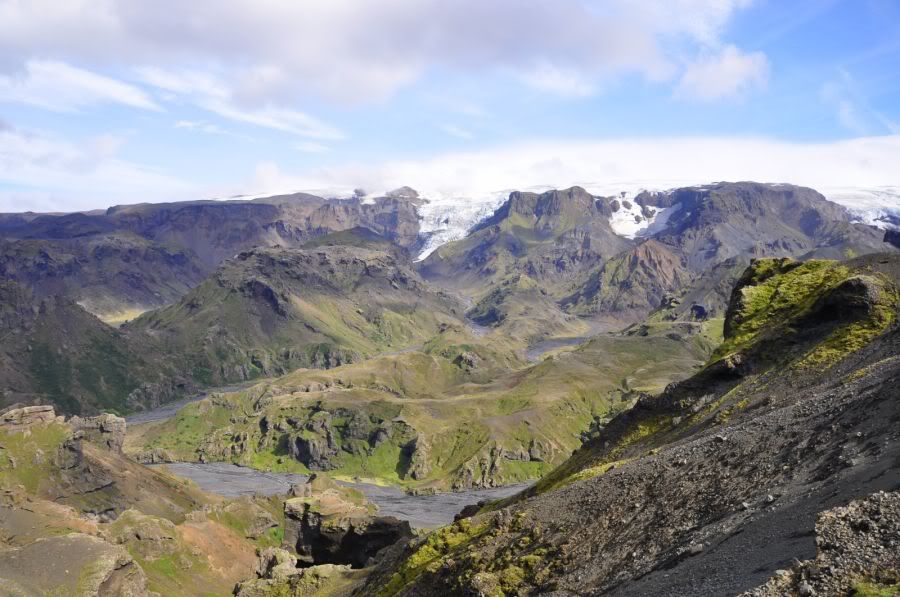
Deze foto is vanaf fimmforduhals, terugkijkend naar het noorden genomen. Boveaan de foto de myrdalsjokull, en het klein stroompje wat daarvandaan komt. vanaf rechtsonder komt de stroom die vanaf fimmforduhals komt. samen vormen ze vanaf de splitsing de rivier markarfljot. Die pslitsing zie je net niet, maar zit linksonder in beeld. Grappig: op die splitsing is een hangbrug (op de laugavegur wandelroute) , en als je op die brug staat, ruik je dat het water naar rotte eieren stinkt. Dat is water wat van onder de gletscher komt, waar vulkanische gassen in het water komen.
Deze rivier is dan niet meer doorwaadbaar...
De brug in thorsmorsk zal ook wel beschadigd raken, en de waterstroom loopt via de markarfljot eerst naar het westen, en kruist dan bij seljalandsfoss de ringweg. Daar zal de grootste schade wel te verwachten zijn.
Mijn foto's op Flickr!
[b]Op 15-09-2006 10:28 schreef Hans_Gielus[/b]
Namens Fryslân hoop ik dat je van een berg afkukelt _O-
[b]Op 15-09-2006 10:28 schreef Hans_Gielus[/b]
Namens Fryslân hoop ik dat je van een berg afkukelt _O-

Lol, idd, maar als het in de bovenste luchtlagen zit is het helemaal niet te voorspellen waar het naar beneden gaat komen, denk maar eens aan saharazand.quote:Op woensdag 14 april 2010 15:36 schreef Isdatzo het volgende:
[..]
Het gaat er meer om wat de wind op grotere hoogte doet. En het ziet er naar uit dat die wel voornamelijk noord-westelijk is (of iig afkomstig uit het..) aankomende tijd.
be nice or go away
Mwah, is wel redelijk te voorspellen hoorquote:Op woensdag 14 april 2010 15:43 schreef kahaarin het volgende:
[..]
Lol, idd, maar als het in de bovenste luchtlagen zit is het helemaal niet te voorspellen waar het naar beneden gaat komen, denk maar eens aan saharazand.
Nu ff regelen dat ik op korte termijn vrij kan krijgen
Huilen dan.


=quote:
Om het een en ander te visualiseren.

Huilen dan.
quote:
Yup.
Er liggen her en der wel wat huisjes als je zo op Google Maps kijkt. En dat vliegveld van Bakki ligt daar mss ook niet optimaal


Nope...quote:Op woensdag 14 april 2010 16:19 schreef Isdatzo het volgende:
[ afbeelding ]
En deze huisjes staan ook niet bepaald strategisch
Flood in South Iceland Might Be Subsiding
Beeld van de meest recente uitbarsting en overstromingen (in WMV-formaat): http://http.ruv.straumar.(...)_eyjafjallajokul.wmv
En de onderbroken Ringroad:
http://www.ruv.is/frett/flodid-virdist-i-renun
NASA Sensors Providing Rapid Estimates of Iceland Volcano Emissions
[ Bericht 12% gewijzigd door Roel_Jewel op 14-04-2010 17:51:27 ]
Beeld van de meest recente uitbarsting en overstromingen (in WMV-formaat): http://http.ruv.straumar.(...)_eyjafjallajokul.wmv
En de onderbroken Ringroad:

http://www.ruv.is/frett/flodid-virdist-i-renun
NASA Sensors Providing Rapid Estimates of Iceland Volcano Emissions
[ Bericht 12% gewijzigd door Roel_Jewel op 14-04-2010 17:51:27 ]
Je link doet het niet.quote:Op woensdag 14 april 2010 21:59 schreef Isdatzo het volgende:
En wat dacht je van deze?
http://vefmidlar.visir.is(...)af7-f2391380301e.asx
Wat een natuurgeweldquote:Op woensdag 14 april 2010 21:59 schreef Isdatzo het volgende:
En wat dacht je van deze?
http://vefmidlar.visir.is(...)af7-f2391380301e.asx

Even kijken hoe de situatie zich ontwikkelt maar als 't een beetje mee zit vertrek ik misschien al de 19e of 21e.
Huilen dan.
Zo duidelijk dat daar in de geschiedenis al vaker een lading water doorheen is gegaanquote:
[ afbeelding ]
En deze huisjes staan ook niet bepaald strategisch
I am a Chinese college students, I have a loving father, but I can not help him, he needs to do heart bypass surgery, I can not help him, because the cost of 100,000 or so needed, please help me, lifelong You pray Thank you!
wow, die beelden
DeLuna vindt me dik ;(
Op zondag 22 juni 2014 12:30 schreef 3rdRock het volgende:
pas als jullie gaan trouwen. nu ben je gewoon die Oom Rubber die met onze mama leuke dingen doet :)
Op zondag 22 juni 2014 12:30 schreef 3rdRock het volgende:
pas als jullie gaan trouwen. nu ben je gewoon die Oom Rubber die met onze mama leuke dingen doet :)
Morgen kans dat er geen vliegverkeer boven de UK en andere delen van Europa mogelijk is:
https://www.cfmu.eurocont(...)IC_ASH_ADVISORY3.pdf
https://www.cfmu.eurocont(...)IC_ASH_ADVISORY3.pdf
Een ballonvaarder die door de mand valt is nooit grappig...

Zijn hier satellietbeelden van te zien?quote:Vluchten geannuleerd door vulkaanuitbarsting IJsland
SCHIPHOL - Het luchtverkeer heeft last van een vulkaanuitbarsting woensdagochtend in IJsland. Tientallen vluchten van en naar Schiphol zijn donderdag geannuleerd wegens een aswolk boven Noord-Europa.
Dat heeft een woordvoerster van Luchtverkeersleiding Nederland gemeld.
Volgens de woordvoerster kan het aantal annuleringen nog oplopen. Het gaat vooral om vluchten naar Noord-Engeland, Schotland en Scandinavië.
Op de Britse vliegvelden zijn negentig procent van de vluchten geannuleerd, meldt BNR Nieuwsradio.
KLM
As van vulkanen kan ertoe leiden dat vliegtuigmotoren plotseling stilvallen. Dat gebeurde in 1989 met een vliegtuig van KLM, dat onderweg was van Schiphol naar Tokio. Bij Alaska vloog het toestel door een wolk van de vulkaan Mount Redoubt.
Het stof verstopte de vier motoren, die ineens uitvielen. De bemanning slaagde erin de motoren te herstarten. Enkele jaren eerder was een vliegtuig van British Airways in de problemen gekomen door een aswolk bij Indonesië. Ook toen kon de bemanning de motoren herstarten.
| Wordfeud: marcel-o |plug.dj/uptempo |<-- draai zelf je platen

I am a Chinese college students, I have a loving father, but I can not help him, he needs to do heart bypass surgery, I can not help him, because the cost of 100,000 or so needed, please help me, lifelong You pray Thank you!