WKN Weer, Klimaat en Natuurrampen
Lees alles over het onstuimige weer op onze planeet, volg orkanen en tornado's, zie hoe vulkanen uitbarsten en hoe Moeder Aarde beeft bij een aardbeving. Alles over de verwoestende kracht van onze planeet en tal van andere natuurverschijnselen.


Welkom! Hier alweer het volgende deel in de reeks Hurricane Season! Alle informatie over het ontstaan van nieuwe orkanen in 2010 vind je hier. En natuurlijk volgen we ze allemaal op de voet! Voor zowel Atlantische, Indische als Pacifische stormen kan je hier terecht
Algemene Info
Met de term 'Hurricane Season' bedoelden we in eerste instantie de periode van 1 juni tot 30 november. Deze periode wordt in de Atlantische Oceaan en de Golf van Mexico gezien als het orkaanseizoen. Echter komen deze gewelddadige stormen overal in de wereld voor en met name in Azië zorgen ze jaarlijks voor duizenden slachtoffers en tienduizenden daklozen. Echter horen we vaak erg weinig over de stormen in Azië en juist meer over die in de VS.
In de laatste jaren zijn Tropische Stormen meer en meer in de media gekomen. Het lijkt ook alsof ze meer en meer slachtoffers maken. Een documentaire over Hurricane Andrew uit 1992, heeft diepe indruk gemaakt en ook zullen kenners orkanen Floyd, Gilbert, Stan en Ivan zich zeker nog herinneren. De catastrofe die "Katrina" met zich meebracht ging de hele wereld over. En dan praten we eigenlijk alleen over de Atlantische stormen en lijken we te vergeten dat er in 2007 meer dan 4000 doden vielen in Bangladesh door orkaan Sidr en orkaan Nargis zorgde voor 80.000 doden in Myanmar alleen al.
Hoewel het Atlantische seizoen pas officieel in juni begint zijn er op andere plekken in de wereld zeker meer orkanen te vinden in de komende maanden. We zullen ook deze dus zeker gaan bespreken. Waarschijnlijk zal de kern van de discussie en de posts gaan over de periode 1 juni tot 30 november. T.z.t. zal er ook wel een NWS-topic worden geopend als een orkaan ook uitgebreid in het nieuws komt.
Orkanen: Hoe ontstaan ze eigenlijk?
Op de site van Wikipedia kan je in het Nederlands nalezen hoe ze ontstaan en wat de belangrijkste energiebron is voor hun verwoestende kracht: het warme zeewater

Ook de BBC heeft er een interessante en leuke animatie over gemaakt.
Ook wordt er op LiveScience in het engels prima uitgelegd hoe ze ontstaan en zich ontwikkelen
Indeling, Kracht en Stormvloed
De stormen worden ingedeeld op 'categorie'. Vaak zijn het eerst tropische stormen" (Tropical Depression, Tropical Storms), die overgaan tot Orkaanstatus (Hurricanes/Tyfoons) Ze worden ingedeeld op windsnelheden via de Saffir-Simpson Schaal.
Door de enorme windkracht van een orkaan wordt het zeewater opgestuwd. Dit zeewater wordt als het ware vooruit geblazen, voor de storm uit. Hoe zwaarder de orkaan des te meer zeewater vooruit wordt geduwd. De stormvloed wordt dan ook gemeten bovenop de reguliere golfslag. Je kan het enigszins vergelijken met een muur van water (tsunami) die vooruit wordt geduwd.
Tropische Depressie: windsnelheden van 38 tot 61 km/u
Tropische Storm: windsnelheden van 62 tot 118 km/u
Orkaan 1e categorie: windsnelheden van 119 tot 153 km/u en een stormvloed van 1 tot 1,5 meter boven normaal
Orkaan 2e categorie: windsnelheden van 154 tot 177 km/u en een stormvloed van 1,5 tot 2,5 meter boven normaal
Orkaan 3e categorie: windsnelhden van 178 tot 209 km/u en een stormvloed van 2,5 tot 3,7 meter boven normaal
Orkaan 4e categorie: windsnelheden van 210-249 km/u en een stormvloed van 3,8 tot 5,5 meter boven normaal
Orkaan 5e categorie: windsnelheden > 250 km/u en een stormvloed van meer dan 5,5 meter boven normaal
TIP: Interactief (film)overzicht van de krachten van orkanen n.a.v. de schaal van Simpson
Waarom hebben orkanen namen?
De Tropische Depressies worden overal ter wereld in de gaten gehouden en zodra de depressies uitgroeien tot orkaan of cycloon, wordt er een naam aan de storm gegeven. Sinds 1950 krijgen ze namen op alfabetische volgorde (met uitzondering van de letters Q, U, X, Y en Z). Mocht een orkaan vernietigend hebben huisgehouden zoals Floyd, Gilbert en bijv. Katrina, dan zal die naam worden vervangen. Soms komt het ook voor dat alle letters van het alfabet gebruikt zijn in één seizoen (zoals 2005), dan zal een volgende storm Alpha gaan heten, gevolgd door Beta etc etc. Voor het orkanenseizoen 2010 zijn de namen als volgt:
Atlantische Stormen 2010
Alex, Bonnie, Colin, Danielle, Earl, Fiona, Gaston, Hermine, Igor, Julia, Karl, Lisa, Matthew, Nicole, Otto, Paula, Richard, Shary, Tomas, Virginie, Walter.
In het Noordoosten van de Pacific ontstaan ook orkanen. Deze zorgen meestal voor weinig schade aan de Amerikaanse/Mexicaanse westkust.
Oost Pacifische Stormen 2010
Agatha, Blas, Celia, Darby, Estelle, Frank, Georgette, Howard, Isis, Javier, Kay, Lester, Madeline, Newton, Orlene, Paine, Roslyn, Seymour, Tina, Virgil, Winifred, Xavier, Yolanda, Zeke
Verder zijn er dan nog de stormen in het Noorden, Zuiden en Westen van de Pacific. Daar worden ze tyfoons en/of cyclonen genoemd. Vooral de stormen in het Noord/Westen komen vaak in het nieuws omdat ze Japan, de Filippijnen, Taiwan en China vaak teisteren, maar ook geheel Zuid Oost Azië kunnen treffen. Meer informatie over de namen van orkanen vind je hier.
Leuk hoor allemaal, maar wanneer zijn die orkaanseizoenen nou precies?
ATLANTISCHE OCEAAN: 1 juni t/m 30 november
NOORD OOST PACIFIC:Begin mei t/m begin november, met piek in augustus/september
NOORD WEST PACIFIC: Begin juli t/m eind november, maar eigenlijk hele jaar door activiteit.
NOORD INDISCHE OCEAAN: april t/m december met pieken in mei en november
ZUID INDISCHE + WEST AUSTRALISCHE OCEAAN: oktober t/m mei met pieken in februari en april
ZUID WEST PACIFIC + OOST AUSTRALISCHE OCEAAN: oktober tot eind april met piek in februari.
Over het algemeen is Mei de rustigste maand en September de zwaarste.
En? Zijn er al verwachtingen en/of voorspellingen voor 2010?
Begin december kwamen de eerste voorspellingen voor 2010 naar buiten. Ze verwachten een boven gemiddeld seizoen. 50 jaar orkaangeschiedenis heeft een zogenaamd gemiddeld orkaanseizoen gecreëerd. 9,6 stormen met naam, 5,9 groeit uit tot orkaan en 2,3 worden superorkanen (cat 4 of 5) Volgens de decemberverwachting is de verwachting dat er in 2010 elf tot zestien ‘naam-stormen’ zullen ontstaan in de Atlantische Oceaan. Zes tot acht groeien uit tot orkaan en drie tot vijf daarvan zullen superorkanen worden. Deze voorspelling kan je hier of hier nog eens nalezen.
Oude Delen
2004 - Deel 1 en Deel 2
2005 - Deel 1 en Deel 2
2006 - Deel 1 en Deel 2
2007 - Deel 1, Deel 2, Deel 3 en Deel 4
2008 - Deel 1 en Deel 2
2009 - Deel 1 en Deel 2
Enkele Links
1. National Hurricane Centre
2. Carribean Storm Network
3. Hurricanezone
4. Hurricane Track
5. Website met satelietbeelden van de Caribbean en de rest van Amerika
6. Intellicast: Geavanceerde satellietfoto's en gifs van aktuele stormen
7. Tropical Weather Underground
8. Tropical Storm Risico's van dit moment
9. Wikipedia Hurricanes/Tyfonen in het algemeen
10. Alle stormen ter wereld van de laatste jaren in overzicht
11. The StormTrack
12. Orkanensite in de Filipijnen
13. Atlantische Orkanensite
14. Actuele orkanen in Australië en De orkaanindeling in Australië
15. Tropische weersite omgeving Australië
16. Mooie site over Orkanen aan de VS kusten
17. Website van NASA over Hurricanes
Opmerkelijke Wikipedia-Links
-- Hurricane Katrina 2005
-- Cyclone Nargis 2008
-- Hurricane Season 2009 - Wikipedia
-- Hurricane Season 2008 - Wikipedia
-- Hurricane Season 2007 - Wikipedia
-- Hurricane Season 2006 - Wikipedia
-- Hurricane Season 2005 - Wikipedia
-- Hurricane Season 2004 - Wikipedia
Actuele Weerradar in Golf van Mexico

Actuele Water temperatuur.
=====================
Heb je informatie over orkanen of wil je gewoon alle orkanen van 2010 volgen, volg dan dit topic
[ Bericht 0% gewijzigd door Frutsel op 20-05-2010 14:14:54 ]


Mooie OP 
Tropical Cyclone EDZANI is de enige storm momenteel. Nu een categorie3, maar hard op weg naar een categorie 4.
Tropical Cyclone EDZANI is de enige storm momenteel. Nu een categorie3, maar hard op weg naar een categorie 4.


Hier nog een leuk Sat-beeld:
Origineel: http://rapidfire.sci.gsfc(...)10007083000.250m.jpg
[ Bericht 15% gewijzigd door Frutsel op 11-01-2010 14:52:46 ]
Origineel: http://rapidfire.sci.gsfc(...)10007083000.250m.jpg
[ Bericht 15% gewijzigd door Frutsel op 11-01-2010 14:52:46 ]

Als er warm water is wil dat nog niks zeggenquote:Op dinsdag 12 januari 2010 10:14 schreef Gummibeer79 het volgende:
Dan wordt dan wellicht een interessant seizoen!
zo lang er weer veel windshear is zoals de afgelopen jaren dan wordt het niks
Wat is windshear?quote:Op dinsdag 12 januari 2010 17:51 schreef SoldMayor het volgende:
[..]
Als er warm water is wil dat nog niks zeggen
zo lang er weer veel windshear is zoals de afgelopen jaren dan wordt het niks

Iets moois. Vooral in combinatie met leuk wat CAPEquote:
Nog 2 Sat-beelden van Edzani: 130110 en 140110:


quote:Tropical Cyclone Magda is expected to intensify further as it approaches the Kimberley coast, reaching category three intensity tonight and possibly reaching category four intensity prior to impacting the coast on Friday. There is the risk of very destructive winds with gusts to 250 kilometres per hour near the cyclone centre on Friday, by which time the cyclone should be close to the coast, between Kuri Bay and Cape Leveque.
Gales with gusts to 100 kilometres per hour may develop in coastal areas between Mitchell Plateau and Cape Leveque tonight as the cyclone approaches. Gales may extend to Derby during Friday and may reach as far south as Bidyadanga including Broome on Saturday.
Heavy rainfall, with falls in excess of 100mm, is expected near the cyclone track in the west Kimberley on Friday and Saturday.
Tides on Friday will be higher than expected between Mitchell Plateau and Cape Leveque with flooding of low lying areas possible.


Orkanen in de 21e eeuw: bijna dubbel zoveel zware
De sterkste Atlantische orkanen kunnen bijna verdubbelen in frequentie aan het einde van de eeuw als de aarde opwarmt, zo luidt een rapport dat vrijdag verscheen in het tijdschrift Science.
Bij de nieuwe studie is gebruik gemaakt van de meest uitgebreide computermodellering van orkanen tot dusver. De resultaten geven aan dat, het totale aantal van de Atlantische cyclonen naar bijna 30 procent minder zou kunnen dalen in de komende 80 jaar. Echter, het aantal van categorie 4 en 5 orkanen, de sterkste en meest destructieve stormen, kan stijgen met 80 procent.
Het eindresultaat kan een 30 procent stijging van de materiële schade zijn, aldus de co-auteur van deze studie Tom Knutson, een klimaatwetenschapper bij de National Oceanic and Atmospheric Administration (NOAA), in een interview.
"Er zullen minder stormen zijn , maar meer van deze intensere stormen, en dat geeft toename van de potentiële schade, 'zei hij. Hij voegde eraan toe dat de 80 procent verhoging neerkomt op ongeveer een verdubbeling in de komende eeuw.
Het gebied ten noordoosten van Cuba en ten oosten van Florida kan de grootste piek in het voorkomen en van de intensiteit van de orkanen zien, zo is in de studie gevonden.
Het onderzoek kan consequenties hebben voor de toeristische industrie van Florida en de Bahama’s waar miljarden in omgaan, en voor de oliewinningen in de Golf van Mexico.
Orkanen die in categorie 4 of 5 op de schaal van 5 van Saffir-Simpson vallen hebben een windsnelheid van ten minste ca. 210 km/uur, en zullen naar verwachting toenemen in frequentie in de komende decennia. Ter vergelijking, de orkaan Katrina, die New Orleans trof in 2005 - waardoor 1833 mensen het leven verloren en er 80 miljard dollar schade ontstond - was slechts een cycloon van categorie 3 toen hij aan land ging.
Bij het uitvoeren van hun studie, zijn onderzoekers uitgegaan van een gemiddelde stijging van de zeeoppervlaktetemperatuur van de tropen van 1,7 graden Celsius, dit als gevolg van opwarming van de aarde in de komende 80 jaar, zegt Knutson. Dergelijke warmere wateren zullen meer leiden tot de vorming van orkanen.
Het totale aantal orkanen zou dalen, zegt Knutson, omdat de omstandigheden in het gebied waar de stormen meestal beginnen naar verwachting minder gunstig zullen zijn voor cycloonvorming.
Echter, die vorm doen en verhuizen van de regio vindt omstandigheden meer kans om de toegevoegde intensiteit stimuleren, zodat de sterkste orkanen meer zullen frequenter worden, legde hij uit.
De belangrijkste stijging in sterkere cyclonen werd gevonden ten noorden van 20 graden, ten noorden van de breedtegraad die loopt ten zuiden van Cuba via het schiereiland Yucatan in Mexico, aldus Morris Bender van NOAA, hoofdauteur van de studie.
Volgens de studie, kan het gebied ten oosten van Florida, met inbegrip van de Bahama's, worden getroffen met drie categorie 4 en 5 cyclonen per decennium.
De toename van de frequentie van sterkere stormen kan bedrijven zoals Blackstone Group LP's Hilton Hotels Corp en cruise operator Carnival Corp, beïnvloeden.
Andere industrie kan ook worden beïnvloed, met inbegrip van olieplatforms en installaties in de Golf van Mexico, geëxploiteerd door bedrijven als BP, Exxon Mobil en Chevron.
Bron: Redorbit.com
vwk
Olga is weer tot leven gekomen boven Australie.
Verderop is een tweede storm bezig om orkaankracht te ontwikkelen.
Verderop is een tweede storm bezig om orkaankracht te ontwikkelen.


quote:Olga has drenched Queensland for days. Several more days of heavy rain is expected. Tropical rainstorm Olga will stall over southeastern Queensland. Nearly 20 inches of rain has already affected northern Queensland over the past week.
Across eastern and southern Queensland, 5-10 inches of rain, locally more than 15 inches, is expected. This includes Queensland's biggest city, Brisbane.
Parts of southern Queensland have suffered drought conditions as of late. So, the rain is not all bad news. Southern Queensland is a major agricultural area, where this rain will be welcome. Despite drought conditions, the rain will be heavy enough for localized flooding.
Rain from Tropical Rainstorm Olga will last through the middle of next week.


quote:orkaan Oli teistert Tahiti
Een zware wervelstorm is gisteren en vandaag over het vakantieparadijs Tahiti geraasd. De storm heeft op de archipel in de Stille Zuidzee aanzienlijke schade aangericht, ook in de toeristische resorts. Verschillende mensen zijn om het leven gekomen. Ruim 4.000 mensen moesten voor cycloon 'Oli in veiligheid gebracht worden, aldus de autoriteiten van Frans-Polynesië.
Bewoners krijgen een rij- en uitgaansverbod, zo berichtte de internetsite '20minutes'. Op de eilanden onder de wind werden een 300-tal woningen vernield of door de zee overspoeld. De golven bereikten een hoogte van meer dan zes meter. Vandaag draaide 'Oli' af naar het zuiden en won daarbij nog aan kracht.

Rene gaat richting de Tonga eilanden.quote:Op woensdag 10 februari 2010 16:09 schreef Frutsel het volgende:
Gaat Pat ook over Frans Polynesie? Of welk gebied ligt daar?
Cycloon Pat is over het kleine Polynesisch eiland Aitutaki geraasd en heeft tot 90 procent van alle woningen vernield.
Op het eiland, dat tot de Cookeilanden behoort, wonen bijna 2.000 mensen. Urenlang ging cycloon 'Pat' met windsnelheden van meer dan 100 kilometer per uur te keer op het eiland. Bomen knapten af, blokkeerden de wegen en beschadigden elektriciteitsleidingen.
Naar verluidt liepen de hotelresorts op Aitutaki niet al teveel schade op. Twee mensen werden door rondvliegende brokstukken gewond. Een ooggetuige verklaarde op Radio New Zealand dat een 30-tal toeristen en 30 inheemsen in een kerk in veiligheid werden gebracht.
Ook voor het hoofdeiland van de Cookeilanden, Rarotonga, riep de premier noodtoestand uit. Scholen en overheidsgebouwen werden uit voorzorg gesloten. Tot de Cookeilanden behoren 15 eilanden. Ze liggen ten noorden van Nieuw-Zeeland.

Rene trekt over de Samoa en Tonga eilanden heen.
quote:Tropical Cyclone RENE-10 of Saffir-Simpson Category 2 affected 27 thousand people with winds above 39mph (63 km/h) and 19 thousand people with hurricane wind strengths (74mph or 119 km/h). In addition, few people are living in coastal areas below 5m and can therefore be affected by storm surge

quote:NOAA komt met een vernieuwde Saffir-Simpson Schaal
NOÄA gaat dit jaar een vernieuwde Saffier - Simpson schaal gebruiken om hurricanes in te delen in categorieën. De vernieuwde schaal krijgt als officiële titel de " Saffir-Simpson Hurricane Wind Scale "
Het verschil met de oude indeling is dat stormvloed uit de schaal is verdwenen. De reden hiervoor is dat de stormsurge en de gevolgen daarvan niet alleen bepaald worden door de intensiteit van de orkaan.
Zo is de stormvloed ook afhankelijk van de grote van het systeem en regionale eigenschappen van het gebied waar de orkaan over heen trekt. Het gevolg was dat een orkaan van een lagere categorie een grotere stormvloed kan hebben dan orkanen van een hogere categorie. Een bekend voorbeeld was hurricane Ike (categorie 2) die een stormvloed had van rond de 3 meter terwijl categorie 4 hurricane Charley nog geen stormvloed had van 1,5 meter. De reden dat Ike een grotere stormvloed had kwam o.a door het feit dat het zo'n groot systeem was.

Dit hangt voor de kust van Brazilie.

quote:A rare weather event is underway in the South Atlantic Ocean, where the basin's 7th recorded tropical or subtropical cyclone of all-time has formed. An area of disturbed weather (Invest 90Q) off the coast of Brazil, near 30S 48W, attained a well-defined surface circulation, top wind speeds of tropical depression strength (35 mph), a warm core in the bottom portion of the atmosphere, and a cold core aloft last night. If this storm had been in the North Atlantic, there is a good chance it would have been named Subtropical Depression One. However, tropical and subtropical storms are so rare in the South Atlantic that there is no official naming of depressions or storms done. The cyclone had top winds of at least 35 mph as seen on an ASCAT pass at 7:02 am EST this morning (Figure 2), and satellite estimates of the storm's intensity topped out at 40 mph (minimum subtropical storms strength) last night. This morning, the satellite estimates are showing that the system has weakened to a 35 mph tropical depression. There is some moderate wind shear interfering with development, and sea surface temperatures are about 25°C, which is about 1°C below what is typically needed to support a tropical storm. The storm is headed eastward out to sea, and is not a threat to any land areas. The models show the storm will lose its tropical characteristics and get absorbed by a frontal system by Saturday.

2010 Hurricane Season will be More Active
quote:AccuWeather.com Hurricane Center meteorologists, led by Chief Long-Range Meteorologist and Hurricane Forecaster Joe Bastardi, have released their early hurricane season forecast for the Atlantic Basin for 2010.
The forecast is calling for a much more active 2010 season with above-normal threats on the U.S. coastline.
"This year has the chance to be an extreme season," said Bastardi. "It is certainly much more like 2008 than 2009 as far as the overall threat to the United States' East and Gulf coasts."
Bastardi is forecasting seven landfalls. Five will be hurricanes and two or three of the hurricanes will be major landfalls for the U.S.
He is calling for 16 to 18 tropical storms in total, 15 of which would be in the western Atlantic or Gulf of Mexico and therefore a threat to land.
In a typical season, there are about 11 named storms of which two to three impact the coast of the United States.
bron
"Kans op extreme orkanen is erg groot dit jaar"
Het orkaanseizoen zal dit jaar vroeg van start gaan en bovengemiddeld zijn. Dat verwachten de meteorologen van AccuWeather, onder leiding van Joe Bastardi, die zich bezig houdt met lange termijnvoorspellingen en orkanen. "Dit jaar is de kans op een extreem seizoen erg groot. Er zullen zeker veel meer orkanen zijn dan in 2008 en 2009 en er zal ook dreiging zijn voor de kust van Amerika", aldus Bastardi.
Bastardi voorspelt zeven orkanen die aan land gaan komen. Vijf van categorie één of twee en twee orkanen van categorie drie tot en met vijf. Ook voorspelt hij 16 tot 18 tropische stormen in totaal, waarvan er 15 zullen voorkomen in de westelijke Atlantische Oceaan of de Golf van Mexico en dus een bedreiging voor het land vormen. In een normaal seizoen zijn er ongeveer 11 stormen, waarvan twee á drie de kust van de Verenigde Staten bereiken.
Er zijn een aantal factoren waarop Bastardi dit baseert:
- De snelle afzwakking El Niño.
- Warmere oceaan temperaturen in de tropische broeikassen in vergelijking met vorig jaar. Weet dat tropische stormen hun energie uit warm water onttrekken.
- Verzwakking van de passaatwinden, die de hoeveelheid droge lucht in de tropen van Afrika verminderen.
- Hogere luchtvochtigheid, die extra opwaartse beweging brengt in de lucht. Dat is gunstig voor ontwikkeling van een tropische storm.
Geschiedenis
Bastardi heeft een aantal orkaanseizoenen (1964, 1995 en 1998) uit het verleden vergeleken met het komende seizoen. Alle waren ze van grote invloed voor de Amerikaanse kust. In 1964 sloeg de orkaan Cleo toe in het zuidoosten van Florida, in de buurt van Miami, als een categorie 2 storm en doodde 217 mensen. In 1995 kwam orkaan Opal aan land in Pensacola (Florida) als een categorie 3 storm. Die storm veroorzaakte een een schadepost van ongeveer 3 miljard dollar. In 1998 trof orkaan Bonnie Wilmington (North Carolina), een categorie 2 storm en later nam de orkaan toe tot categorie 3. Bonnie veroorzaakte aanzienlijke schade aan gewassen en in totaal was er ongeveer voor 1 miljard dollar schade.
Zoals Bastardi vorig jaar had voorspeld, lag het Atlantisch orkaanseizoen (2009) ver onder het gemiddelde met elf tropische depressies. Slechts negen van deze werden tropische stormen. Dat was het laagste aantal sinds 1997. Het Atlantisch orkaanseizoen begint officieel op 1 juni en gaat door tot 30 november. Deze data werden geselecteerd omdat 97 procent van de orkaanactiviteit voorkomt gedurende deze periode van zes maanden. (onweer-online.nl)
hln
Het blijven voorspellingen, men heeft er wel vaker naast gezeten
* I intend to live forever, so far so good! *

Cat 5 wordt het zelfs. Ik ben benieuwd hoe dicht deze bij Australie gaat komen.quote:
[ Bericht 5% gewijzigd door #ANONIEM op 13-03-2010 16:12:12 ]
TOMAS (rechts) nu een cat 1
ULUI (links) nu een cat 3
[ Bericht 0% gewijzigd door #ANONIEM op 13-03-2010 19:56:26 ]
ULUI (links) nu een cat 3

[ Bericht 0% gewijzigd door #ANONIEM op 13-03-2010 19:56:26 ]
Tropische storm eist 14 doden in Madagaskar
hlnquote:Drie dagen lang teisterde de tropische storm 'Hubert' het eiland Madagaskar. De balans is zwaar: 14 doden en meer dan 27.000 mensen zijn dakloos. Duizenden huizen raakten beschadigd en liepen onder water.
Moeilijke hulpverlening
Volgens de nationale tv-zender is de regio rond de stad Mananjary, in het zuiden van het land, het zwaarst getroffen. Een vierde van de stad zou onder water staan, zo luidt het bij het National Office for Disaster and Risk Management (BNGRC). Ook de stroom- en watervoorziening zijn onderbroken. Doordat vele straten niet toegankelijk zijn, konden er nog geen hulpgoederen naar Mananjary gebracht worden. (dpa/eb)


Cat.4 Orkaan Tomas teistert Fiji Eilanden
We zullen eens wat vaker topics apart gaan openen voor orkanen of bijv aardbevingen. Eens kijken of we dan het aantal views kunnen opkrikken. De centrale topics kunnen er wat mij betreft gewoon tussendoor blijven lopen.
[ Bericht 78% gewijzigd door Frutsel op 15-03-2010 11:14:57 ]
We zullen eens wat vaker topics apart gaan openen voor orkanen of bijv aardbevingen. Eens kijken of we dan het aantal views kunnen opkrikken. De centrale topics kunnen er wat mij betreft gewoon tussendoor blijven lopen.
[ Bericht 78% gewijzigd door Frutsel op 15-03-2010 11:14:57 ]
Lekker. Mijn zoons zijn zondagochtend geland op Nadi en ik heb nog niets gehoord. Nu weet ik waarom niet.quote:Op maandag 15 maart 2010 11:05 schreef Frutsel het volgende:
Cat.4 Orkaan Tomas teistert Fiji Eilanden
We zullen eens wat vaker topics apart gaan openen voor orkanen of bijv aardbevingen. Eens kijken of we dan het aantal views kunnen opkrikken. De centrale topics kunnen er wat mij betreft gewoon tussendoor blijven lopen.
woef

Ului lijkt toch richting Australie te gaan. Er zijn door wel een aantal grote steden.
Mackay, Gladstone, Brisbane.
Mackay, Gladstone, Brisbane.

Gifje van ULUI van maandag t/m maandag.
Volgens GFS zou deze orkaan ergens tussen Brisbane en Gladstone tercht komen, daar even blijven rondtollen en vervolgens weer de zee optrekken.
[ Bericht 16% gewijzigd door #ANONIEM op 15-03-2010 20:10:49 ]
Volgens GFS zou deze orkaan ergens tussen Brisbane en Gladstone tercht komen, daar even blijven rondtollen en vervolgens weer de zee optrekken.

[ Bericht 16% gewijzigd door #ANONIEM op 15-03-2010 20:10:49 ]
Queensland holds its breath as Cyclone Ului tracks parallel with coast
bronquote:WEATHER Bureau forecasters predict Cyclone Ului will turn south today, tracking parallel with the Queensland coast.
But the US Joint Typhoon Warning Centre has the cyclone easing and veering towards the coast in an area between Fraser Island and Airlie Beach on Friday.
Ului was situated south of the Solomon Islands yesterday, 1400km northeast of Mackay and moving west-southwest at 7km/h. That is about half its speed of the previous day.
Forecaster Geoff Doueal said it was common for models to disagree.
"There's not much (weather conditions) steering this at the moment, so it's a wait and see," he said.
Ului drifted slowly west yesterday, but its longer-term track remained uncertain.
quote:Tropische storm Madagaskar eist 28 doden
Op het eiland Madagaskar is de dodentol na de tropische storm Hubert van vorige week opgelopen tot 28. De meeste slachtoffers vielen nadat een aardverschuiving verschillende huizen vernielde in het district Mananjary, in het zuiden van het land. Dat hebben de lokale media gemeld.
In Mananjary vielen acht doden. Een vierde van de regio stond onder water en de stroom- en watervoorziening waren onderbroken.
De storm maakte meer dan 20.000 mensen dakloos, zo meldt het National Office for Disaster and Risk Management
Vrij vroeg in het seizoen maar nummer TWO is er al in W.Pacific...
belooft nog wat vorig jaar was maar telleurstellend
belooft nog wat

Nou de W.Pacific heeft altijd zware stormen ( cat.5 ) maar vorig viel dat wel mee...
Tsjaa daar op de philipijnen ging het wel mis maja
Tsjaa daar op de philipijnen ging het wel mis maja

Euh?
Dit beloofd niet veel goeds Nu al de temperaturen die normaliter in Juni of Juli voorkomen?
Voor je het weet heb je in April de eerste orkaan
quote:Sea surface temperature anomalies in the Atlantic are now getting ridiculous, seriously! A huge area is now 2 degrees Celsius above normal but even more concerning is the vast area that is fully 1 degree+ Celsius above normal. To put it in perspective, these temperatures are already where we would expect to see them in... June or July.
Dit beloofd niet veel goeds
Voor je het weet heb je in April de eerste orkaan

Ter info, bron nu.nl
AMSTERDAM – Het komende orkaanseizoen zal erg actief worden. Dit meldt het KNMI aan de hand van verwachtingen van klimaatonderzoekers. Zij baseren zich op de temperatuur van het zeewater.
Zo zou het zeewater op dit moment zeer warm zijn in het gebied waar de meeste orkanen ontstaan.
De verwachting is volgens het KNMI dat het water zeker de eerste maanden van het orkaanseizoen nog steeds warmer zal zijn dan gemiddeld. Boven warm water ontstaan meer orkanen.
El Niño en La Niña
Het gebied van de Atlantische Oceaan moet daarom rekenen op een zeer actief orkaanseizoen. Ook El Niño en La Niña kunnen hierop van invloed zijn. El Niño en La Niña zijn benamingen voor een afwijking van de zeewatertemperatuur in de Stille Oceaan nabij de evenaar.
De kans is volgens de onderzoekers groot dat de El Niño van de afgelopen periode na de zomer zal omslaan in een La Niña, waarbij het zeewater veel kouder is. Deze verandering heeft het ontstaan van tropische stormen en orkanen tot gevolg.
Het orkaanseizoen in de Atlantische regio begint in juni en eindigt in november. Voorspellingen over de activiteit in het orkaanseizoen komen vaak uit. Zo was het vorig jaar erg rustig, wat van te voren verwacht werd.
Het wordt nat in het noorden van Australie, door toedoen van Tropische storm Paul.
[ Bericht 10% gewijzigd door #ANONIEM op 28-03-2010 19:17:59 ]

[ Bericht 10% gewijzigd door #ANONIEM op 28-03-2010 19:17:59 ]
Ik vrees dat het echt een drama gaat worden in de Atlantische Oceaan de komende zomer...
's Avonds een man, overdags rustig an
Arm Haitiquote:Op zondag 4 april 2010 22:10 schreef Burnie88 het volgende:
Ik vrees dat het echt een drama gaat worden in de Atlantische Oceaan de komende zomer...
69% kans dat een major (cat 4/5) hurricane de kust van de VS gaat treffen. We wait and see...quote:Update April 2010: Busy Hurricane Season ahead
The Atlantic basin is facing a busier-than-usual hurricane season, in part because of record warm water in the ocean, according to the latest hurricane forecast.
Colorado State University's forecast, released Wednesday, calls for 15 named tropical storms this year in the Atlantic basin, which includes the Carribean and Gulf of Mexico. The team says eight will become hurricanes, with sustained winds reaching 74 mph. Four are expected to be major hurricanes — Categories 3, 4 or 5 — with maximum wind speeds of 111 mph or greater.
The average Atlantic hurricane season, going back to 1950, has 10 named storms — six of them hurricanes, and two of those major.
"The probability of a major hurricane making landfall along the U.S. coastline is 69%, compared with the last-century average of 52%," says William Gray, a member of Colorado State's Tropical Meteorology Project.
At the end of March, the part of the Atlantic Ocean where hurricanes form was the warmest it has ever been for this time of year, says Phil Klotzbach, the team's lead forecaster. "The average water temperature is about 78 degrees," he says. Hurricanes need water temperatures of about 80 degrees to form.
Forecasters say the unusually warm water, coupled with the diminishing El Niño in the Pacific, will lead to an active season. El Niño produces strong winds at upper levels of the atmosphere that tear developing hurricanes apart, which is what caused the quiet season last year.
Insurance companies, emergency managers and the news media use the forecasts from Colorado State to prepare Americans for the season's likely hurricane threat.
Since 2000, the team has under-forecast the number of named tropical storms and hurricanes four times, over-forecast three times, and been almost right — within two storms — three times, a USA TODAY analysis shows. In 2009, the team predicted 12 named storms and six hurricanes. Nine named storms actually formed, including three hurricanes.
Last month, the private forecasting firm AccuWeather predicted 16 to 18 tropical storms and hurricanes would form, and seven would make landfall on U.S. shores.
Hurricane season runs from June 1 to Nov. 30. The first named storm will be Alex.

Twee weken ofzo zonder orkaan... nu dus weer eentje bij Australië al lijkt hij ongevaarlijk voor land
Zie ook --> Gezonken booreiland - Grootste milieuramp allertijden?quote:Orkaanseizoen geeft complicaties bij olievervuiling
Het nieuwe orkaanseizoen kan vanaf 1 juni extra complicaties opleveren bij de olievervuiling in de Golf van Mexico. Tegen de tijd dat het orkaanseizoen aanbreekt, is het olieprobleem nog niet opgelost. Dit zegt directeur water Piet Dircke van ingenieursbureau Arcadis.
Arcadis is in de Amerikaanse stad New Orleans betrokken bij de aanleg van stormvloedkeringen en dijkverhogingen na de overstromingen die de orkaan Katrina in 2005 veroorzaakte. De recente olieramp zal niet direct van invloed zijn op de werkzaamheden van het ingenieursbureau bij de bescherming van de stad in Louisiana.
,,De olie zal New Orleans niet bereiken'', weet Dircke. ,,Maar over de combinatie van de olieramp met een hurricane is nog niet goed nagedacht. De rotzooi is dan misschien niet te overzien.''
Tja... met een beetje mazzel begint het pas eind juli te spoken in de Golf qua orkanen, maar ja.. dit jaar verwacht men al meer orkanen.. dus het kan ook gelijk misgaan
quote:2010 Atlantic hurricane season could rank in the top ten
The upcoming hurricane season could be a top ten active year, a stark contrast from the relatively calm 2009 season.
AccuWeather.com Chief Hurricane Meteorologist Joe Bastardi predicts a total of 16-18 storms this season. To put that in perspective, only eight years in the 160 years of records have had 16 or more storms in a season.
The season should start early with one or two threats by early July, and stay late with additional threats extending well into October.
His forecast team expects at least six storms to impact the United States coastline--slightly more than one out of every three. In a normal year, one out of every five named storms (20 percent) in the Atlantic basin impacts the United States. In the 2005 season, 36 percent of the storms affected the United States, while 50 percent impacted the U.S. in 1998 and 2008.
"From the standpoint of number of storm threats from the tropics to the U.S. coastline, we will at least rival 2008, and in the extreme case, this season could end up in a category only exceeded by 2005," Bastardi said.
Bastardi observes a rapid warming of the Gulf of Mexico and the collapsing El Nino pattern, which were both characteristics of the 1998 and 2005 seasons.
Named storms moving through the Gulf of Mexico can cause major disruption to both oil and gas production. In 2008, shutdown of production caused a decline in production of 62 million barrels of oil and 408 billion cubic feet of gas. In the record-setting season of 2005, nearly three months of production time was lost.
According to Bastardi, the Atlantic basin looks "textbook" for a major season, with many long track storms that make their way from off the coast of Africa into the western Atlantic and Caribbean heading toward the U.S. coastline.
He adds that in the heart of the season, there will be a "congregation of tracks," or a concentrated area where many of the storm tracks will pass through.
"I believe there will be a bunching of tracks in the area around the Antilles and into the Bahamas," he said.
Hurricane season begins June 1 and ends Nov. 30.
Ik ben benieuwd of de gebieden in de indische oceaan zich gaan ontwikkelen tot orkaan. Gebied ten oosten van Afrika en ten oosten van India. Het ziet er wel dreigend uit.
[ Bericht 25% gewijzigd door #ANONIEM op 17-05-2010 12:02:07 ]

[ Bericht 25% gewijzigd door #ANONIEM op 17-05-2010 12:02:07 ]

In deze regio vallen meestal veel slachtoffers. Eerst gaat de cycloon langs de kust om vervolgens Bangladesh te treffen.
Watertemperatuur ligt hier rond de 32 graden.
Watertemperatuur ligt hier rond de 32 graden.

quote:Tropical cyclone could hit India and Bangladesh
Meteorologists are warning a tropical cyclone could hit the east coast of India and Bangladesh putting thousands of homes and scores of lives at risk.
Officials have issued a cyclone alert at ports in the eastern state of Orissa and begun preparations for mass evacuations amid fears of flooding.
Authorities in Bangladesh have also warned fishing boats to stay close to shore and not to venture into deep water.
Early monsoon rains increase the prospect of better rice, corn and soybean crops but cyclones are a regular hazard through the summer months.
India is battered regularly during the stormy season in the Bay of Bengal between April and November.
Last year, 169 people were killed by Tropical Cyclone Aila. Millions more living in India and Bangladesh had their lives disrupted.
And last month, a nor'wester – large storm systems that develop in the Bay of Bengal during the summer – struck the states of Bihar and West Bengal, killing 137 people and leaving thousands of people homeless.
The latest cyclone, named Laila, is gusting at up to 40mph but is still some 400 miles east of Chennai.
Forecasts suggest it could reach speeds of 120mph and – if it continues on course – hit land on Thursday in Andhra Pradesh, home to steel plants and oil refineries and ports.
"The system is likely to intensify into a cyclonic storm and move initially in a north-westerly direction towards Andhra Pradesh coast," said a statement issued by the The India Meteorological Department.


40000 mensen zijn geevacueerd en er zijn al meldingen van doden.
quote:India evacuates 40,000 as cyclone approaches southern state
NEW DELHI, May 20 (Xinhua) -- Indian authorities have evacuated over 40,000 people from coastal areas of southern Indian state of Andhra Pradesh in the anticipation of cyclone Laila which is expected to land in the state, said officials Thursday.
However, cyclonic storm Laila is showing signs of weakening before hitting the seashore, said Indian meteorological officials.
Heavy rains with gales has killed 10 people and crippled life in the coastal region of the state, as the cyclone is expected to cross the coast between Kavali and Kakinada, close to Machilipatnam in Andhra Pradesh by Thursday afternoon.
Dat zou wat zijn... voor 1 juni al een tropische stormquote:Two named storms in Atlantic before June 1st?
There is at least a chance that we could see two named storms before we ever reach June 1. The upcoming pattern just might support such a rare occurrence but I am not sold on it just yet. Here are the facts:
Sea surface temps are running anywhere from .5 to almost 2.0 degrees C above normal across the Gulf of Mexico and Caribbean Sea. This anomaly is fairly significant but it is not enough, by itself, to produce tropical storms and hurricanes.
Looking at the latest computer models, specifically the GFS and ECMWF, both of which are pretty good at sniffing out development, we see that both indicate the chance for development in two different areas. The GFS is forecasting a low pressure area to form in about five days well to the norheast of Puerto Rico. Taking a look at the FSU Cyclone Phase Diagram for this event, which helps to determine whether or not a cyclone or storm system is warm core (tropical) or cold core (non-tropical), we see that initially, this low would be warm core and fairly symmetric- meaning it could warrant being named if in fact it forms at all. However, the system would quickly move over cooler waters and likely transition in to an eztra-tropical storm, losing its warm, tropical characteristics. Both the GFS and the ECMWF "see" this system developing within about five days. It will be something to keep an eye on but doubt it would play any role in the weather for land areas.
The next area to watch will be the SW Caribbean Sea. The GFS has been forecasting the development of a weak tropical cyclone in this region for the last several days. However, the run to run consistency has not been very solid, meaning that sometimes it shows up well organized, other times it does not. The argument for development is also the fact that a more favorable upper level wind pattern should set up across the Caribbean Sea over the next week to 10 days. But this is uncertain to be sure and thus I believe that anything that does try to get going in the Caribbean would be more of a rain maker than anything else. However, this poses a big problem for Haiti should any such development get too close to that country. Even a tropical wave or depression could bring several inches of rain to the region in short order- so we'll want to keep an eye on anything that tries to organize in the Caribbean Sea this season.
The bottom line is that we are approaching the start to the Atlantic hurricane season. Water temps are running at record levels above normal in a good deal of the Atlantic Basin and so the potential for a very busy season lies ahead. This time of year is not favored for development but it cannot be ruled out. The good news is that nothing appears to be threatening the Gulf of Mexico and we see nothing that suggests a hurricane is in the works anytime soon. I guess the real concern is again for Haiti as any rain maker will be trouble for recovery efforts and the ongoing post-earthquake crisis.
1 Juni (zie de openingspost )
Al gebeurd er vaak in juni nog bijzonder weinig... (uitzonderingen daargelaten)
Al gebeurd er vaak in juni nog bijzonder weinig... (uitzonderingen daargelaten)
Dan heb ik daar overheen gelezenquote:Op donderdag 20 mei 2010 14:03 schreef Frutsel het volgende:
1 Juni (zie de openingspost
Al gebeurd er vaak in juni nog bijzonder weinig... (uitzonderingen daargelaten)
voor juni is idd aan de vroege kant, ben benieuwd of ze de eerste dan ook June gaan noemen.quote:Op donderdag 20 mei 2010 14:03 schreef Frutsel het volgende:
1 Juni (zie de openingspost
Al gebeurd er vaak in juni nog bijzonder weinig... (uitzonderingen daargelaten)
Hopelijk is het geen voorbode voor een heel zwaar seizoen trouwens, Tropische stormen/hurricanes/tyfonen e.d. zijn geen grapjes.
be nice or go away
Alles wijst op een extreem seizoen... ze verwachten een bijzonder zwaar seizoen, deels door el nino.
Watertemperaturen rijzen nu al de pan uit... gemiddeld 0.5 tot 2 graden warmer dan normaal voor deze periode. Zelfs in het rampjaar 2005 begonnen we pas op 8 juni met de eerste tropische storm.
Zal de olierotzooi geen goed doen als er ook nog een orkaan overheen dendert
Eerste stormen zullen trouwens Alex en Bonnie gaan heten
Owkeej, nu maar hopen op hardlopers zijn doodlopers dan...quote:Op donderdag 20 mei 2010 14:19 schreef Frutsel het volgende:
Alles wijst op een extreem seizoen... ze verwachten een bijzonder zwaar seizoen, deels door el nino.
Watertemperaturen rijzen nu al de pan uit... gemiddeld 0.5 tot 2 graden warmer dan normaal voor deze periode. Zelfs in het rampjaar 2005 begonnen we pas op 8 juni met de eerste tropische storm.
Zal de olierotzooi geen goed doen als er ook nog een orkaan overheen dendert
Eerste stormen zullen trouwens Alex en Bonnie gaan heten
Die olie zal dan idd behoorlijk verspreid worden dan, ik vraag me af wat dat dan gaat doen voor de landbouwgrond in dat gebied, oliezooi moet toch flink gesaneerd worden voordat er weer verbouwd mag worden.
Oh, maak je geen zorgen om Bonnie, die zit op het moment netjes in de kooi, het rechter vogeltje in mijn ava.
be nice or go away
Is dit wel een goed idee? Als er zo vroeg wordt gewaarschuwd dan is de kans groter dat ze er naast zitten toch? Hurricanes willen nog wel eens van richting veranderen voor de kust, zitten ze er een paar keer naast dan zijn er vast mensen die denken dat het wel mee valt en dan komt hij wel daar aan land.
het lijkt me dat zoiets niet zo precies is te voorspellen als ze nu zeggen, voor niets evacueren doe je ook niet te vaak achter elkaar. Maar goed, misschien zijn ze nu wel accurater, ik kan me iig nog wel herinneren hoe het ging met, volgens mij, Gustav, die is volgens mij tot 2 keer toe niet op de voorspelde plek aan land gekomen. (eerst de vraag welk eiland en daarna de vraag waar hij aan land ging in via golf van Mexico.)
Is dat nu echt zo veel verbeterd dat ze vervroegde waarschuwingen kunnen geven zodat mensen eerder weg gaan? Alsvast je huis stormklaar maken, okay, maar eerder het huis uit?
[ Bericht 0% gewijzigd door kahaarin op 20-05-2010 15:15:09 ]
http://www.mahalo.com/2010-hurricane-season-forecastquote:Earlier Warnings Issued This Year
The U.S. National Hurricane Center will announce storm watches and warnings 12 hours earlier than in previous hurricane seasons. The earlier lead time will give those living in coastal areas more time to prepare and evacuate. Officials can give more advance warnings and watches because of advances in tracking storms and forecasting their projected paths.
het lijkt me dat zoiets niet zo precies is te voorspellen als ze nu zeggen, voor niets evacueren doe je ook niet te vaak achter elkaar. Maar goed, misschien zijn ze nu wel accurater, ik kan me iig nog wel herinneren hoe het ging met, volgens mij, Gustav, die is volgens mij tot 2 keer toe niet op de voorspelde plek aan land gekomen. (eerst de vraag welk eiland en daarna de vraag waar hij aan land ging in via golf van Mexico.)
Is dat nu echt zo veel verbeterd dat ze vervroegde waarschuwingen kunnen geven zodat mensen eerder weg gaan? Alsvast je huis stormklaar maken, okay, maar eerder het huis uit?
[ Bericht 0% gewijzigd door kahaarin op 20-05-2010 15:15:09 ]
be nice or go away
Hoe heet die linker dan? St.Claire?quote:
[..]
Owkeej, nu maar hopen op hardlopers zijn doodlopers dan...
Die olie zal dan idd behoorlijk verspreid worden dan, ik vraag me af wat dat dan gaat doen voor de landbouwgrond in dat gebied, oliezooi moet toch flink gesaneerd worden voordat er weer verbouwd mag worden.
Oh, maak je geen zorgen om Bonnie, die zit op het moment netjes in de kooi, het rechter vogeltje in mijn ava.
Ach ja, ze zitten er wel vaker naast met die voorspellingen, vorig jaar was er niets te doen en hadden ze een gemiddeld seizoen verwacht, maar niet één orkaan kwam aan land. Dus wie weet... 2005 was weliswaar bovengemiddeld verwacht, maar niet zo extreem als dat het werd.
Volgens mij komt er volgende week een nieuwe voorspelling/verwachting
Hmm...quote:Op donderdag 20 mei 2010 10:59 schreef aloa het volgende:
40000 mensen zijn geevacueerd en er zijn al meldingen van doden.
[..]
Doden door cycloon in India
quote:De zuidkust van India is donderdag getroffen door cycloon Laila. Slagregens geselden het kustgebied van de deelstaat Andhra Pradesh en winden van negentig kilometer per uur rukten bomen en elektriciteitsmasten uit de grond.
Op voorhand werden meer dan vijftigduizend mensen geëvacueerd uit vrees voor mogelijk de ergste storm in veertien jaar. Toch verloren in 24 uur tijd vijftien mensen het leven. Zeker 55 vissers worden vermist. Zes districten hadden te kampen met stroomuitval en honderden dorpen werden tien uur lang in duisternis gehuld.
be nice or go away
16 doden, overstromingen, veel schade en geen stroom meer in delen van India.
quote:Cyclone Laila moves towards Orissa, rains in Andhra
Cyclone Laila weakened ahead of landfall about 30 km from Bapatla in Guntur district in Andhra Pradesh on Thursday but still left 16 people dead, flooded thousands of homes, snapped power supply in many areas and threw rail and road traffic out of gear in the coastal region of the state.
Though Laila's intensity reduced considerably, the winds blowing at a speed of 90-95 kmph continue to leave behind a trail of destruction, though not of the level that was feared before it made the landfall.
It rained all night in most parts of Bapatla in Guntur and even now it is raining, accompanied by strong winds.
While the depression is moving towards Orissa now, the Meteorological department has said that vigil should continue in coastal Andhra Pradesh today as well.
Under the influence of this system, widespread rainfall activity is likely over coastal Andhra Pradesh and Telangana and Orissa during next 24 hours. (After striking Andhra, Cyclone Laila heads towards Orissa)
The sea condition will be very rough along and off Andhra Pradesh and Orissa coast during next 12 hours. Fishermen have been are advised not to venture into the sea during next 48 hours.

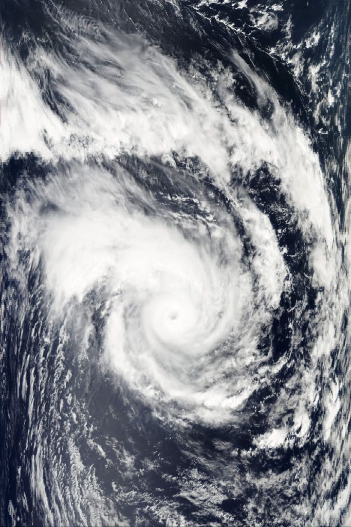
quote:Tropical Cyclone Laila hovered over the eastern coastline of India and the Bay of Bengal, and skirted Sri Lanka on May 19, 2010. The Moderate Resolution Imaging Spectroradiometer (MODIS) on NASA’s Aqua satellite captured this natural-color image the same day. Spanning hundreds of kilometers, the storm extends a spiral arm toward the northeast, covering much of India’s coast. In the south, the storm spans most of southern India.
On May 19, 2010, the U.S. Navy’s Joint Typhoon Warning Center (JTWC) reported that Tropical Cyclone Laila had maximum sustained winds of 65 knots (120 kilometers per hour) and gusts up to 80 knots (150 kilometers per hour). Roughly 80 nautical miles (150 kilometers) northeast of the coastal city of Chennai (Madras), the storm had moved toward the north-northwest over the previous several hours.
As Laila traveled along the Indian coastline, both the United Nations Office for the Coordination of Humanitarian Affairs and the Dartmouth Flood Observatory reported severe flooding, including some casualties, in India and Sri Lanka. Some of the flooding, however, occurred before Laila developed into a named storm, and was associated with other weather fronts.
Dodental stijgt op Sri Lanka en in India.
quote:Doden na overstromingen Sri Lanka
Bij overstromingen en aardverschuivingen als gevolg van zware regenval zijn in Sri Lanka zeker twintig mensen om het leven gekomen. Dat heeft de Sri Lankaanse regering vrijdag gezegd. De meeste doden vielen in het westelijke district Gampaha.
Volgens de regering zijn veel huizen ondergelopen en zijn wegen weggespoeld. De marine probeert mensen die vast zitten te redden en helpt bij de verspreiding van hulpgoederen.
Trouw
quote:Dodental cycloon India gestegen
(Novum/AP) - Het dodental als gevolg van een krachtige cycloon die het zuidoosten van India heeft getroffen is gestegen naar 23. Donderdagnacht kwamen vier mensen om het leven bij een aardverschuiving in de stad Vijawyada.
Slagregens geselden woensdag het kustgebied van de deelstaat Andhra Pradesh en winden van honderd kilometer per uur rukten bomen en elektriciteitsmasten uit de grond. De storm zorgde voor aardverschuivingen in het kuststadje Bapatla. Golven van meer dan drie meter hoog troffen de Indiase kust.
Op voorhand werden meer dan vijftigduizend mensen geëvacueerd uit vrees voor mogelijk de ergste storm in veertien jaar. Toch verloren sinds woensdag 23 mensen het leven. Zeker 55 vissers worden vermist. Zes districten hadden te kampen met stroomuitval en honderden dorpen werden tien uur lang in duisternis gehuld.
In het noorden van India kwamen tien mensen om het leven bij een krachtig onweer. Zes mensen overleden toen hun huis vlakbij het dorp Allahabad in de deelstaat Uttar Pradesh instortte.
Trouw
Yeah 1st invest van 2010quote:Op vrijdag 21 mei 2010 14:46 schreef aloa het volgende:
Dat zou inderdaad een vroege start kunnen worden.
[ afbeelding ]
Tropische storm bij Somalie heeft de naam "Bandu" gekregen.
[ Bericht 3% gewijzigd door #ANONIEM op 22-05-2010 13:06:13 ]
[ Bericht 3% gewijzigd door #ANONIEM op 22-05-2010 13:06:13 ]
quote:An extratropical low pressure system has developed a few hundred miles northeast of the Bahamas today, and has been designated as the first "Invest" of the year (90L) by the National Hurricane Center. (For those of you who were wondering, a discussion of what an "Invest" is can be found in the Tropical Cyclone FAQ). This low has the potential to develop into the season's first named storm--Alex--and could be a threat to the Southeast U.S. coast by Tuesday. Wind shear is currently 40 knots over the low, and the high shear ripped apart a low level circulation that was attempting to form this morning. Water vapor loops show a large amount of dry, continental air exists to the west of the storm, and this dry air will hamper transition of 90L to a subtropical storm. This system is expected to move slowly northwestward towards the Southeast U.S. coast, and could bring 20 - 30 mph winds and heavy rain to the coast of North Carolina by Tuesday. While the storm will initially form in a region of high wind shear and be entirely extratropical, it will move into a region of lower wind shear in a gap between the polar jet stream to the north and the subtropical jet stream to its south early next week. At that time, the low will be positioned near the warm waters of the Gulf Stream, and will have the opportunity to develop a shallow warm core and transition to a subtropical storm. The models are divided on whether the storm will eventually make landfall on the Southeast U.S. coast 5 - 7 days from now, and it is too early to offer odds on this occurring. The counter-clockwise flow of air around this low will probably lead to northeasterly winds over the oil spill region Tuesday through Wednesday, keeping oil away from the coasts of Alabama and the Florida Panhandle, but pushing oil southwards towards the Loop Current. Wunderbloggers Weather456 and StormW have more detailed discussions of the potential development of 90L.
Nee, dat viel mij ook al op. Terwijl er toch een kans is dat dit de eerste storm wordt met een naam.quote:Op zaterdag 22 mei 2010 13:57 schreef Vogue het volgende:
Da's extreem vroeg


En hier wat additional info:
Bronquote:Atlantic Tropical Weather Outlook
--------------------------------------------------------------------------------
000
ABNT20 KNHC 240024
TWOAT
SPECIAL TROPICAL WEATHER OUTLOOK
NWS TPC/NATIONAL HURRICANE CENTER MIAMI FL
825 PM EDT SUN MAY 23 2010
FOR THE NORTH ATLANTIC...CARIBBEAN SEA AND THE GULF OF MEXICO...
A NON-TROPICAL LOW PRESSURE SYSTEM CENTERED ABOUT 500 MILES
SOUTH-SOUTHWEST OF BERMUDA IS PRODUCING A LARGE AREA OF
DISORGANIZED SHOWERS AND THUNDERSTORMS OVER THE SOUTHWESTERN
ATLANTIC OCEAN ALONG WITH GALE-FORCE WINDS. THIS LOW IS EXPECTED
TO MOVE SLOWLY TOWARD THE NORTH-NORTHWEST AND HAS SOME POTENTIAL
TO GRADUALLY ACQUIRE SUBTROPICAL OR TROPICAL CHARACTERISTICS DURING
THE NEXT COUPLE OF DAYS. THERE IS A MEDIUM CHANCE...30
PERCENT...OF THIS SYSTEM BECOMING A SUBTROPICAL OR TROPICAL CYCLONE
DURING THE NEXT 48 HOURS. FOR ADDITIONAL INFORMATION...PLEASE SEE
HIGH SEAS FORECASTS ISSUED BY THE NATIONAL WEATHER SERVICE...UNDER
AWIPS HEADER NFDHSFAT1 AND WMO HEADER FZNT01 KWBC. THE NEXT
STATEMENT ON THIS SYSTEM WILL BE ISSUED BY MIDDAY MONDAY.
FORECASTER BLAKE