WKN Weer, Klimaat en Natuurrampen
Lees alles over het onstuimige weer op onze planeet, volg orkanen en tornado's, zie hoe vulkanen uitbarsten en hoe Moeder Aarde beeft bij een aardbeving. Alles over de verwoestende kracht van onze planeet en tal van andere natuurverschijnselen.


Handige linkjes:
� Onweerlinks 'live'
� Stormvue-sites
� Cape en voorspellende kaarten
� Wolkenkaarten en foto's
� Diverse weersites
� Achtergrond informatie
� Golven en wind
� Buienradar Nederland
� Buienradar West Europa
Overige informatie:
� Vorige delen 'De atmosfeer staat op ontploffen'
� Openingpost 'De atmosfeer staat op ontploffen'
mijn laatste post
Heb net mijn ouders gesproken, blijkt dat gisteren de bliksem voor hun huis ingeslagen is. Via een boom in de grond, mensen die het gezien hebben zeiden dat het een bolbliksem was. Het wordt nog erger, er stond ook een meisje onder die boom te schuilen, helemaal in paniek maar had gelukkig niets. Ik zal een foto van de krater maken.
Zo zie je maar dat je nooit onder een boom moet gaan schuilen.

quote:Op vrijdag 8 augustus 2008 12:06 schreef the_RAVEN het volgende:
mijn laatste post
Heb net mijn ouders gesproken, blijkt dat gisteren de bliksem voor hun huis ingeslagen is. Via een boom in de grond, mensen die het gezien hebben zeiden dat het een bolbliksem was. Het wordt nog erger, er stond ook een meisje onder die boom te schuilen, helemaal in paniek maar had gelukkig niets. Ik zal een foto van de krater maken.
Zo zie je maar dat je nooit onder een boom moet gaan schuilen.
Ben benieuwd naar je foto.
Life is Music
Inderdaad, ben wel benieuwd naar die pic, the -Raven.....quote:Op vrijdag 8 augustus 2008 12:09 schreef Roel_Jewel het volgende:
[..]. Die heeft dan ook geluk gehad
.
be nice or go away
zal vandaag niet meer lukken denk ik, heel misschien vanavond. Ik moet eerst ergens anders fotos gaan maken.
En het waait niet meer, lekker alle ramen open, heerlijk.quote:
Ik gooi de foto nog wel even in de herhaling, ik vind hem mooi.

[ Bericht 28% gewijzigd door kahaarin op 08-08-2008 12:54:55 ]
be nice or go away
zo zeg. nooit slim om onder bomen te schuilen iddquote:Op vrijdag 8 augustus 2008 12:06 schreef the_RAVEN het volgende:
mijn laatste post
Heb net mijn ouders gesproken, blijkt dat gisteren de bliksem voor hun huis ingeslagen is. Via een boom in de grond, mensen die het gezien hebben zeiden dat het een bolbliksem was. Het wordt nog erger, er stond ook een meisje onder die boom te schuilen, helemaal in paniek maar had gelukkig niets. Ik zal een foto van de krater maken.
Zo zie je maar dat je nooit onder een boom moet gaan schuilen.
Toen ik klein was een blikseminslag meegemaakt naast het huis bij mijn ouders. Ik lag in bed en schrok mij een ongeluk, nooit meer zo'n knal gehoord! Onze buurman vertelde dat hij na de inslag een vuurbal zag rollen over het betonpad die zo de kas achter het huis in verdween. Hij dacht dat alle ruiten er wel uit zouden knallen, maar er was verder geen zichtbare schade
Raar spul, bliksem...
[b]Op maandag 6 september 2010 00:28 schreef tong80 het volgende:[/b]
GVD Wat moet jij een trotse vader zijn :)
:P
GVD Wat moet jij een trotse vader zijn :)
:P
Apeldoorn meld onweer. Regen valt hier nog mee, kleine 3km verder schijnt het keihard te regenen.
Drugs are good mkay?

Grotendeels grijs maar meest droog weer in Eindhoven  .
.
/edit op het moment dat ik het typ begint het weer te regenen
/edit op het moment dat ik het typ begint het weer te regenen
♫
Het zonnetje schijnt voor mijn meisje 

Toch kan er nog een enkele bui vallen als ik de radarbeelden zo bekijk. Wel een toenemende wind
Toch kan er nog een enkele bui vallen als ik de radarbeelden zo bekijk. Wel een toenemende wind
Doe mee met het voorspellen van het weer!
Weekvoorspelling | Week 12 (invullen tot 16-03 - 11:59)
Maandvoorspelling Maart (Inzendingen gesloten)
Jaarvoorspelling 2025 / 2026
Weekvoorspelling | Week 12 (invullen tot 16-03 - 11:59)
Maandvoorspelling Maart (Inzendingen gesloten)
Jaarvoorspelling 2025 / 2026

Heb niets gezegd, het valt er goed uit nuquote:Op vrijdag 8 augustus 2008 12:51 schreef knep het volgende:
Grotendeels grijs maar meest droog weer in Eindhoven
/edit op het moment dat ik het typ begint het weer te regenen
♫
Mooi meisje, gefeliciteerd!quote:Op vrijdag 8 augustus 2008 12:56 schreef SpeedyGJ het volgende:
Het zonnetje schijnt voor mijn meisje
Toch kan er nog een enkele bui vallen als ik de radarbeelden zo bekijk. Wel een toenemende wind
http://www.buienradar.nl/h.aspx?jaar=-3&soort=loop1uur1x1_bliksem
Het lijntje trekt nu richting Dld, er zijn nog wel een boel buitjes in Nederland maar het lijkt alsof daar geen onweer meer in zit, is er nog kans op meer onweer of was dit het wel?
be nice or go away
Laatste bui van vandaag gehad, en maar goed ook..want er past niet veel water meer in de vijver. 
Life is Music
Volgens mij krijg ik vandaag weer nix...  augustus duurd gelukkig nog even. Morgen naar Tsjechie. Mischien daar wel onweer
Never Stop Exploring!
Life begins at the end of your comfort zone!
Follow me on Twitter: https://twitter.com/EdwinKr83 Instagram: https://www.instagram.com/edwinkr83/
Life begins at the end of your comfort zone!
Follow me on Twitter: https://twitter.com/EdwinKr83 Instagram: https://www.instagram.com/edwinkr83/
En weer onweer dat op Apeldoorn afkomt.
Edit 1 minuut later
HOOOOOOOOSbui
En of het hard gaat
Edit 1 minuut later
HOOOOOOOOSbui
En of het hard gaat
Drugs are good mkay?
* Oldbie heeft altijd zin in herfstquote:Op vrijdag 8 augustus 2008 14:53 schreef Fredo55 het volgende:
Eigenlijk heb ik wel zin in de herfst, de zomer word toch niks meer.


Je bent me net voor:quote:Op vrijdag 8 augustus 2008 15:32 schreef Roel_Jewel het volgende:
[ afbeelding ]
http://gizmodo.com/503445(...)usand-slo+mo-cameras
http://www.flabber.nl/archief/024776.php

* N.icka houdt zichzelf inquote:Op vrijdag 8 augustus 2008 17:15 schreef Roel_Jewel het volgende:
Alsof er EMMERS water naar beneden komen. Zoveel valt hier nu
Foto van gisterenavond

Experience is what you get when you don't get what you wanted
Take my advice ... I don't use it anyway...
Een goede Fok! Search
Een goede Fok! Search
Take my advice ... I don't use it anyway...
Een goede Fok! Search
Een goede Fok! Search
Vorig jaar:
dit noemen ze ook wel dweilen met de kraan open
Gisteren:
Het is in deze straat elk jaar wel raak.

dit noemen ze ook wel dweilen met de kraan open
Gisteren:

Het is in deze straat elk jaar wel raak.
Life is Music
Ah kijk, er is ook een 'onweertopic' op fok  .
.
Op vakantie aantal mooie buien gezien, dus hier ook maar weer 's wat meer in de gaten houden.
Op vakantie aantal mooie buien gezien, dus hier ook maar weer 's wat meer in de gaten houden.
"If we knew what it was we were doing, it would not be called research, would it?'
quote:Op vrijdag 8 augustus 2008 23:42 schreef Radio-silence het volgende:
[..]
Ze is haar caravan aan het leegpompen!
Ze is haar huis leeg aan het pompen, maar dat is gewoon dom omdat
het water evenwijdig met het huis staat.
Life is Music
we hebben het wel weer gehad zo te zien
Op naar de volgende depressie.
Op naar de volgende depressie.
Do what you love, love what you do!
Depressie? Waar heb je het over.. niks van gemerkt hier? Mis ik watquote:Op zaterdag 9 augustus 2008 01:09 schreef kree het volgende:
we hebben het wel weer gehad zo te zien
Op naar de volgende depressie.
'In de stad York zal plaatsvinden een ineenstorting, twee tweelingbroers uiteengerukt door chaos. Terwijl het fort valt zal de grote leider vallen.Derde grote oorlog zal beginnen als de grote stad brandt.'
Wat is het prachtig weer momenteel zonnetje maar wel wat meer bewoking merk ik nu pas  toenemende wind draaiend naar west.
Doe mee met het voorspellen van het weer!
Weekvoorspelling | Week 12 (invullen tot 16-03 - 11:59)
Maandvoorspelling Maart (Inzendingen gesloten)
Jaarvoorspelling 2025 / 2026
Weekvoorspelling | Week 12 (invullen tot 16-03 - 11:59)
Maandvoorspelling Maart (Inzendingen gesloten)
Jaarvoorspelling 2025 / 2026
Ik heb gisteren de onweerkrater gezien en gefotografeerd, helaas kampt mijn pc momenteel met een virus. Ik moet zeggen het is een krater ter grote van een paal, ik kon het niet laten om mijn hand erin te steken maar het was echt niets bijzonders. Ik zal zo snel mogelijk de foto plaatsen.
Ik heb ook het meisje (toevallig) gesproken en het ging echt om een bolbliksem: "hij sloeg in de grond en stuiterde weer omhoog, het was net een discobal".
Ik heb ook het meisje (toevallig) gesproken en het ging echt om een bolbliksem: "hij sloeg in de grond en stuiterde weer omhoog, het was net een discobal".
Buien ter hoogte van Londen en op weg richting NL, zie sat24!
Groningen(stad): mooie blauwe luchten en een frisse temperatuur van ongeveer 18 graden.
Groningen(stad): mooie blauwe luchten en een frisse temperatuur van ongeveer 18 graden.
Oh, pc gemeutquote:Op vrijdag 8 augustus 2008 12:13 schreef the_RAVEN het volgende:
zal vandaag niet meer lukken denk ik, heel misschien vanavond. Ik moet eerst ergens anders fotos gaan maken.
Er klopt geen reet van die fotoquote:Op vrijdag 8 augustus 2008 20:32 schreef Fredo55 het volgende:
Vorig jaar:
[ afbeelding ]
dit noemen ze ook wel dweilen met de kraan open
Das gewoon een buitje, en hij neemt nog af ookquote:Op zaterdag 9 augustus 2008 11:53 schreef Radio-silence het volgende:
Buien ter hoogte van Londen en op weg richting NL, zie sat24!
Groningen(stad): mooie blauwe luchten en een frisse temperatuur van ongeveer 18 graden.
Prachtig weer zeg 19.9 graden en best veel wind.
Doe mee met het voorspellen van het weer!
Weekvoorspelling | Week 12 (invullen tot 16-03 - 11:59)
Maandvoorspelling Maart (Inzendingen gesloten)
Jaarvoorspelling 2025 / 2026
Weekvoorspelling | Week 12 (invullen tot 16-03 - 11:59)
Maandvoorspelling Maart (Inzendingen gesloten)
Jaarvoorspelling 2025 / 2026

nog een paar foto's van de shelf over Delft afgelopen donderdag 
en een kleine 20 min kwam er nog een kleinere (en lelijkere) shelf langs


en een kleine 20 min kwam er nog een kleinere (en lelijkere) shelf langs

The line is a dot to you!
Dammmmm ikzag op buienradar dat de regen front bij Apeldoorn is en ik zit nog lekker te genieten in de tuin (Enschede) en ik voel regen druppels.
Sorry voor de evt. spelfouten maar ik heb een lichte vorm van dyslectie

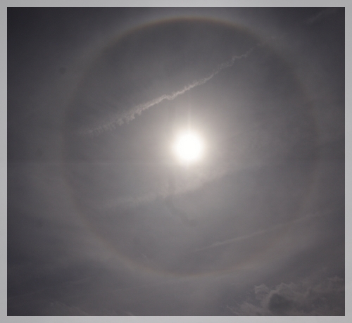
IJskristallen hoog in de lucht?quote:Op zondag 10 augustus 2008 00:50 schreef _Flea_ het volgende:
Iemand die mij kan vertellen hoe onderstaande regenboog kan ontstaan?
[ afbeelding ]
Lijkt mij een halo, ontstaat inderdaad door ijskristallen.
Een regenboog ontstaat door weerkaatsing van zonlicht in regendruppels, een halo door weerkaatsing in ijs. Het is trouwens een voorbode op een weersverslechtering.
Een regenboog ontstaat door weerkaatsing van zonlicht in regendruppels, een halo door weerkaatsing in ijs. Het is trouwens een voorbode op een weersverslechtering.
Life is Music
Ik heb deze foto afgelopen woensdag gemaakt. Toen was het nog erg heet. Dagen daarna is het idd minder geworden.quote:Op zondag 10 augustus 2008 12:27 schreef Fredo55 het volgende:
Lijkt mij een halo, ontstaat inderdaad door ijskristallen.
Een regenboog ontstaat door weerkaatsing van zonlicht in regendruppels, een halo door weerkaatsing in ijs. Het is trouwens een voorbode op een weersverslechtering.
Had het nog nooit gezien, dus heb het maar vastgelegd.
Ja idd, ik heb het woensdag ook gezien toen ik in de achtertuin zat te zonnen.quote:Op zondag 10 augustus 2008 13:05 schreef _Flea_ het volgende:
[..]
Ik heb deze foto afgelopen woensdag gemaakt. Toen was het nog erg heet. Dagen daarna is het idd minder geworden.
Had het nog nooit gezien, dus heb het maar vastgelegd.
Hier in Zeeland een windkracht 6.
edit:
Heb deze foto ff gejat op weerwoord, foto is gemaakt in Torhout door Miguel,
uiteraard ook op woensdag.
Life is Music
Flink wat wind zeg in belgie zijn pieken naar 72km/h gemeld
Doe mee met het voorspellen van het weer!
Weekvoorspelling | Week 12 (invullen tot 16-03 - 11:59)
Maandvoorspelling Maart (Inzendingen gesloten)
Jaarvoorspelling 2025 / 2026
Weekvoorspelling | Week 12 (invullen tot 16-03 - 11:59)
Maandvoorspelling Maart (Inzendingen gesloten)
Jaarvoorspelling 2025 / 2026

Net bij 't journaal beelden van Dublin e.o. Ondergelopen snelwegen na een recordhoeveelheid neerslag .
http://www.irishtimes.com(...)8/0810/breaking4.htm
http://www.irishtimes.com(...)8/0810/breaking4.htm
quote:Clean-up continues after record rains cause flash floods
A major clean-up operation is getting underway this morning after record rainfall caused serious flooding overnight which closed road and rail links across the country and saw a number of major events cancelled.
Met Eireann's weather station in Dublin Airport recorded 76.2mm of rain between midnight on Friday night and midnight last night, 3mm more than was recorded on the previous wettest day when Hurricane Charlie hit in 1985.
The record levels of rainfall have left a large number of roads impassable including the M50 between the Finglas and Ballymun exits and the Port Tunnel.
A section of NI in the direction of Dublin Airport is also closed at Whitehall and detours through Santry are in place
The N3 remains closed between Blanchardstown and Clonee and motorists are experiencing long delays along the stretch. The Swords Road at Shantalla Bridge is completely impassable.
Units of the Civil Defence have been mobilised in Dublin to help the fire brigade pump water from homes and businesses.
Kilkenny, Cork and Kildare fans heading to Dublin for All-Ireland hurling and football quarter finals in Croke Park have been asked to avoid the M50 and to expect severe delays.
In Kildarde, the town of Celbridge was badly affected with sewage causing serious problems after backing up on to the town's main street and flood waters reaching over over two feet in some housing estates.
In Co Laois there is serious flooding on the road between Ballyroan and Portlaoise after a river burst its banks. The road has not been closed but motorists have been urged to proceed with caution.
Last night's football match between Shamrock Rovers and Sunderland in Tolka Park was cancelled and the Tullamore Show has also been called off for the second year running due to the weather.
It had been expected to attract 50,000 spectators and is the country’s biggest one-day rural event.
“Due to the unprecedented amount of rain that has fallen over the last 24 hours, the current state of the showgrounds, the health and safety of visitors and the welfare of show animals the executive committee are bitterly disappointed to announce that this year’s Tullamore Show and AIB National Livestock Show has been cancelled," the show's organisers said in a statement.
Racing at the Curragh has also been called off.
The Dart link between Malahide and Howth Junction has reopened while rail services heading north are also running normally following disruptions yesterday evening and this morning.
While conditions have brightened this morning, more wet weather is on the way. The remainder of today will be showery and tomorrow heavy rain in the west is expected to spread to all areas by mid-morning, with a risk of thunder and further localised flooding.
Conditions will remain unsettled for most of the week with temperatures struggling to make the high-teens by Wednesday and Thursday.
Hier in Maassluis al sinds ik wakker ben (12 uur) zonnig en droog. Maar wel veel wind uit het zuidwesten.
What Would Goku Do
Nog een beste woei hier, vanmiddag stoten naar 46.6km/h
Doe mee met het voorspellen van het weer!
Weekvoorspelling | Week 12 (invullen tot 16-03 - 11:59)
Maandvoorspelling Maart (Inzendingen gesloten)
Jaarvoorspelling 2025 / 2026
Weekvoorspelling | Week 12 (invullen tot 16-03 - 11:59)
Maandvoorspelling Maart (Inzendingen gesloten)
Jaarvoorspelling 2025 / 2026
Aantrekkende wind bewolkt en 17.9 graden.
Doe mee met het voorspellen van het weer!
Weekvoorspelling | Week 12 (invullen tot 16-03 - 11:59)
Maandvoorspelling Maart (Inzendingen gesloten)
Jaarvoorspelling 2025 / 2026
Weekvoorspelling | Week 12 (invullen tot 16-03 - 11:59)
Maandvoorspelling Maart (Inzendingen gesloten)
Jaarvoorspelling 2025 / 2026
weet niet hoor.. voorlopig liggen we nieteens onder de 1 Zelfs nieteens onderdeel van de thunderstorms 
Mah ik verwacht niet al te veel, hoog uit aan het einde van de middag een kracht 6 tot 7 bft langs de kust, al kan een kanaalrat soms nog wel leuker uitpakken, maar of het er 1 wordt, mah heb mijn twijfels, wel kans op windstoten naar 80km/h al verwacht ik niet hoger
Doe mee met het voorspellen van het weer!
Weekvoorspelling | Week 12 (invullen tot 16-03 - 11:59)
Maandvoorspelling Maart (Inzendingen gesloten)
Jaarvoorspelling 2025 / 2026
Weekvoorspelling | Week 12 (invullen tot 16-03 - 11:59)
Maandvoorspelling Maart (Inzendingen gesloten)
Jaarvoorspelling 2025 / 2026
Hoe zit het met de foto van die krater...quote:Op zaterdag 9 augustus 2008 10:07 schreef the_RAVEN het volgende:
Ik heb gisteren de onweerkrater gezien en gefotografeerd, helaas kampt mijn pc momenteel met een virus. Ik moet zeggen het is een krater ter grote van een paal, ik kon het niet laten om mijn hand erin te steken maar het was echt niets bijzonders. Ik zal zo snel mogelijk de foto plaatsen.
Ik heb ook het meisje (toevallig) gesproken en het ging echt om een bolbliksem: "hij sloeg in de grond en stuiterde weer omhoog, het was net een discobal".
'In de stad York zal plaatsvinden een ineenstorting, twee tweelingbroers uiteengerukt door chaos. Terwijl het fort valt zal de grote leider vallen.Derde grote oorlog zal beginnen als de grote stad brandt.'
* daanski82 kijkt naar buiten en ziet geen bewegende bomen/bladeren.
ik heb maar de ventilator weer aan gezet om het versneld te koelen.
ik heb maar de ventilator weer aan gezet om het versneld te koelen.
Sorry voor de evt. spelfouten maar ik heb een lichte vorm van dyslectie
Midden Limburg meld een klein onweersbuitje met veel regen
Vi är Borg. Motstånd är meningslöst. Ni kommer att bli assimilerade!!
Drachten meld overtrekkend onweersbuitje met veel water
Foar de kofje net eamelje en dernei ek net...

update van estofex zojuist
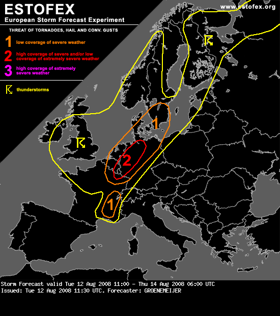
quote:Storm Forecast
Valid: Tue 12 Aug 2008 11:00 to Thu 14 Aug 2008 06:00 UTC
Issued: Tue 12 Aug 2008 11:30
Forecaster: GROENEMEIJER
SYNOPSIS
Not much changes ahead as major upper trough is still in place over NW-Europe. Numerous disturbances rotate around this trough, resulting in unsettled conditions over most parts of central and N-Europe. Still hot and stable conditions over the Mediterranean and SE/E-Europe.
DISCUSSION
A low pressure area over British isles is the most prominent feature on the weather maps. Around an associated mid/upper-level low over Ireland, a strong cyclonically-curved jet extends across northern Iberia via central France into NW Germany.
N France, SE Benelux, NW and N Germany...
Within the section of the jet over western continental Europe, a speed maximum/jet streak over NE France should move northeastward during the remainder of the day. In the lower troposphere, a baroclinic wave has developed. At 11 UTC, the surface cold front of the wave was located near a line from Amsterdam to Luxembourg to Dijon.
Ahead of the surface cold front, surface winds are generally between south and southeast, which creates 100-250 m2/s2 of 0-3 km storm relative helicity. About 500-1000 J/kg of surface-based CAPE is expected here. Strong deep-layer (0-6 km bulk) shear of 25-35 m/s should create an environment conducive to updraft rotation. Relatively high near-surface buoyancy release for surface parcels will probably support low-level rotation as well.
Rotating storms have already been observed by Doppler radar across NE Belgium and SE Netherlands. Further development of a number of small supercells capable of producing tornadoes, possibly including a few strong ones (F2/F3) are expected across the SE Benelux, Lorraine, the Rhineland, Northrhine-Westphalia and Lower Saxony, before moving to north-central parts of Germany later today. Additionally, isolated large hail and some strong/severe straight-line winds are expected.
E Denmark, S and SE Sweden...
These areas will likely be affected by the aformentioned frotnal wave overnight. As it appears as though kinematics will remain favourable for rotating updrafts throughout the night, a few tornadoes may occur here as well even though less buoyancy will be available for surface parcels.
SE France ...
About 25 m/s of 0-6 km bulk shear and 1000-2000 J/kg CAPE should produce an environement conducive of a few, possibly rotating, storms. The main threat of these storms appear to be large hail and excessive rainfall.
* I intend to live forever, so far so good! *