WKN Weer, Klimaat en Natuurrampen
Lees alles over het onstuimige weer op onze planeet, volg orkanen en tornado's, zie hoe vulkanen uitbarsten en hoe Moeder Aarde beeft bij een aardbeving. Alles over de verwoestende kracht van onze planeet en tal van andere natuurverschijnselen.


Prachtig weer zeg  19.9 graden en best veel wind.
Doe mee met het voorspellen van het weer!
Weekvoorspelling | Week 12 (invullen tot 16-03 - 11:59)
Maandvoorspelling Maart (Inzendingen gesloten)
Jaarvoorspelling 2025 / 2026
Weekvoorspelling | Week 12 (invullen tot 16-03 - 11:59)
Maandvoorspelling Maart (Inzendingen gesloten)
Jaarvoorspelling 2025 / 2026

nog een paar foto's van de shelf over Delft afgelopen donderdag 
en een kleine 20 min kwam er nog een kleinere (en lelijkere) shelf langs


en een kleine 20 min kwam er nog een kleinere (en lelijkere) shelf langs

The line is a dot to you!
Dammmmm ikzag op buienradar dat de regen front bij Apeldoorn is en ik zit nog lekker te genieten in de tuin (Enschede) en ik voel regen druppels.
Sorry voor de evt. spelfouten maar ik heb een lichte vorm van dyslectie

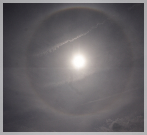
IJskristallen hoog in de lucht?quote:Op zondag 10 augustus 2008 00:50 schreef _Flea_ het volgende:
Iemand die mij kan vertellen hoe onderstaande regenboog kan ontstaan?
[ afbeelding ]
Lijkt mij een halo, ontstaat inderdaad door ijskristallen.
Een regenboog ontstaat door weerkaatsing van zonlicht in regendruppels, een halo door weerkaatsing in ijs. Het is trouwens een voorbode op een weersverslechtering.
Een regenboog ontstaat door weerkaatsing van zonlicht in regendruppels, een halo door weerkaatsing in ijs. Het is trouwens een voorbode op een weersverslechtering.
Life is Music
Ik heb deze foto afgelopen woensdag gemaakt. Toen was het nog erg heet. Dagen daarna is het idd minder geworden.quote:Op zondag 10 augustus 2008 12:27 schreef Fredo55 het volgende:
Lijkt mij een halo, ontstaat inderdaad door ijskristallen.
Een regenboog ontstaat door weerkaatsing van zonlicht in regendruppels, een halo door weerkaatsing in ijs. Het is trouwens een voorbode op een weersverslechtering.
Had het nog nooit gezien, dus heb het maar vastgelegd.
Ja idd, ik heb het woensdag ook gezien toen ik in de achtertuin zat te zonnen.quote:Op zondag 10 augustus 2008 13:05 schreef _Flea_ het volgende:
[..]
Ik heb deze foto afgelopen woensdag gemaakt. Toen was het nog erg heet. Dagen daarna is het idd minder geworden.
Had het nog nooit gezien, dus heb het maar vastgelegd.
Hier in Zeeland een windkracht 6.
edit:
Heb deze foto ff gejat op weerwoord, foto is gemaakt in Torhout door Miguel,
uiteraard ook op woensdag.
Life is Music
Flink wat wind zeg  in belgie zijn pieken naar 72km/h gemeld
Doe mee met het voorspellen van het weer!
Weekvoorspelling | Week 12 (invullen tot 16-03 - 11:59)
Maandvoorspelling Maart (Inzendingen gesloten)
Jaarvoorspelling 2025 / 2026
Weekvoorspelling | Week 12 (invullen tot 16-03 - 11:59)
Maandvoorspelling Maart (Inzendingen gesloten)
Jaarvoorspelling 2025 / 2026

Net bij 't journaal beelden van Dublin e.o. Ondergelopen snelwegen na een recordhoeveelheid neerslag .
http://www.irishtimes.com(...)8/0810/breaking4.htm
http://www.irishtimes.com(...)8/0810/breaking4.htm
quote:Clean-up continues after record rains cause flash floods
A major clean-up operation is getting underway this morning after record rainfall caused serious flooding overnight which closed road and rail links across the country and saw a number of major events cancelled.
Met Eireann's weather station in Dublin Airport recorded 76.2mm of rain between midnight on Friday night and midnight last night, 3mm more than was recorded on the previous wettest day when Hurricane Charlie hit in 1985.
The record levels of rainfall have left a large number of roads impassable including the M50 between the Finglas and Ballymun exits and the Port Tunnel.
A section of NI in the direction of Dublin Airport is also closed at Whitehall and detours through Santry are in place
The N3 remains closed between Blanchardstown and Clonee and motorists are experiencing long delays along the stretch. The Swords Road at Shantalla Bridge is completely impassable.
Units of the Civil Defence have been mobilised in Dublin to help the fire brigade pump water from homes and businesses.
Kilkenny, Cork and Kildare fans heading to Dublin for All-Ireland hurling and football quarter finals in Croke Park have been asked to avoid the M50 and to expect severe delays.
In Kildarde, the town of Celbridge was badly affected with sewage causing serious problems after backing up on to the town's main street and flood waters reaching over over two feet in some housing estates.
In Co Laois there is serious flooding on the road between Ballyroan and Portlaoise after a river burst its banks. The road has not been closed but motorists have been urged to proceed with caution.
Last night's football match between Shamrock Rovers and Sunderland in Tolka Park was cancelled and the Tullamore Show has also been called off for the second year running due to the weather.
It had been expected to attract 50,000 spectators and is the country’s biggest one-day rural event.
“Due to the unprecedented amount of rain that has fallen over the last 24 hours, the current state of the showgrounds, the health and safety of visitors and the welfare of show animals the executive committee are bitterly disappointed to announce that this year’s Tullamore Show and AIB National Livestock Show has been cancelled," the show's organisers said in a statement.
Racing at the Curragh has also been called off.
The Dart link between Malahide and Howth Junction has reopened while rail services heading north are also running normally following disruptions yesterday evening and this morning.
While conditions have brightened this morning, more wet weather is on the way. The remainder of today will be showery and tomorrow heavy rain in the west is expected to spread to all areas by mid-morning, with a risk of thunder and further localised flooding.
Conditions will remain unsettled for most of the week with temperatures struggling to make the high-teens by Wednesday and Thursday.
Hier in Maassluis al sinds ik wakker ben (12 uur) zonnig en droog. Maar wel veel wind uit het zuidwesten.
What Would Goku Do
Nog een beste woei hier, vanmiddag stoten naar 46.6km/h
Doe mee met het voorspellen van het weer!
Weekvoorspelling | Week 12 (invullen tot 16-03 - 11:59)
Maandvoorspelling Maart (Inzendingen gesloten)
Jaarvoorspelling 2025 / 2026
Weekvoorspelling | Week 12 (invullen tot 16-03 - 11:59)
Maandvoorspelling Maart (Inzendingen gesloten)
Jaarvoorspelling 2025 / 2026
Aantrekkende wind bewolkt en 17.9 graden.
Doe mee met het voorspellen van het weer!
Weekvoorspelling | Week 12 (invullen tot 16-03 - 11:59)
Maandvoorspelling Maart (Inzendingen gesloten)
Jaarvoorspelling 2025 / 2026
Weekvoorspelling | Week 12 (invullen tot 16-03 - 11:59)
Maandvoorspelling Maart (Inzendingen gesloten)
Jaarvoorspelling 2025 / 2026
weet niet hoor.. voorlopig liggen we nieteens onder de 1  Zelfs nieteens onderdeel van de thunderstorms
Mah ik verwacht niet al te veel, hoog uit aan het einde van de middag een kracht 6 tot 7 bft langs de kust, al kan een kanaalrat soms nog wel leuker uitpakken, maar of het er 1 wordt, mah heb mijn twijfels, wel kans op windstoten naar 80km/h al verwacht ik niet hoger
Doe mee met het voorspellen van het weer!
Weekvoorspelling | Week 12 (invullen tot 16-03 - 11:59)
Maandvoorspelling Maart (Inzendingen gesloten)
Jaarvoorspelling 2025 / 2026
Weekvoorspelling | Week 12 (invullen tot 16-03 - 11:59)
Maandvoorspelling Maart (Inzendingen gesloten)
Jaarvoorspelling 2025 / 2026
Hoe zit het met de foto van die krater...quote:Op zaterdag 9 augustus 2008 10:07 schreef the_RAVEN het volgende:
Ik heb gisteren de onweerkrater gezien en gefotografeerd, helaas kampt mijn pc momenteel met een virus. Ik moet zeggen het is een krater ter grote van een paal, ik kon het niet laten om mijn hand erin te steken maar het was echt niets bijzonders. Ik zal zo snel mogelijk de foto plaatsen.
Ik heb ook het meisje (toevallig) gesproken en het ging echt om een bolbliksem: "hij sloeg in de grond en stuiterde weer omhoog, het was net een discobal".
'In de stad York zal plaatsvinden een ineenstorting, twee tweelingbroers uiteengerukt door chaos. Terwijl het fort valt zal de grote leider vallen.Derde grote oorlog zal beginnen als de grote stad brandt.'
* daanski82 kijkt naar buiten en ziet geen bewegende bomen/bladeren.
ik heb maar de ventilator weer aan gezet om het versneld te koelen.
ik heb maar de ventilator weer aan gezet om het versneld te koelen.
Sorry voor de evt. spelfouten maar ik heb een lichte vorm van dyslectie

Midden Limburg meld een klein onweersbuitje met veel regen 
Vi är Borg. Motstånd är meningslöst. Ni kommer att bli assimilerade!!
Drachten meld overtrekkend onweersbuitje met veel water
Foar de kofje net eamelje en dernei ek net...

update van estofex zojuist
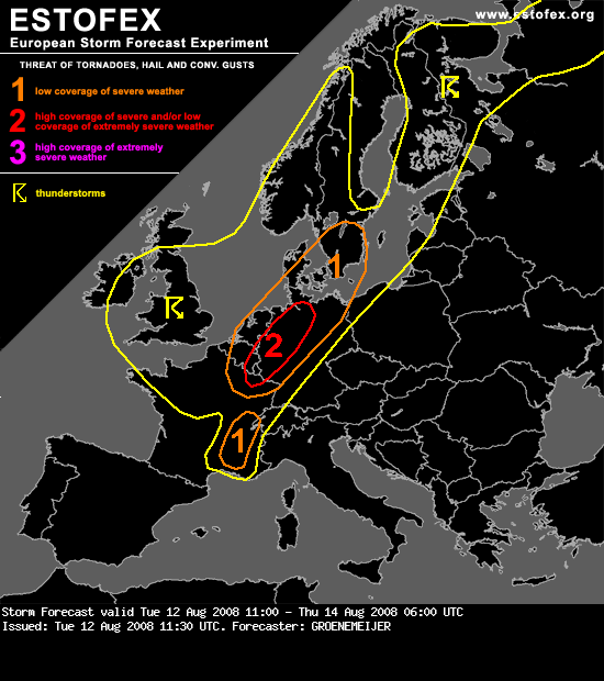
quote:Storm Forecast
Valid: Tue 12 Aug 2008 11:00 to Thu 14 Aug 2008 06:00 UTC
Issued: Tue 12 Aug 2008 11:30
Forecaster: GROENEMEIJER
SYNOPSIS
Not much changes ahead as major upper trough is still in place over NW-Europe. Numerous disturbances rotate around this trough, resulting in unsettled conditions over most parts of central and N-Europe. Still hot and stable conditions over the Mediterranean and SE/E-Europe.
DISCUSSION
A low pressure area over British isles is the most prominent feature on the weather maps. Around an associated mid/upper-level low over Ireland, a strong cyclonically-curved jet extends across northern Iberia via central France into NW Germany.
N France, SE Benelux, NW and N Germany...
Within the section of the jet over western continental Europe, a speed maximum/jet streak over NE France should move northeastward during the remainder of the day. In the lower troposphere, a baroclinic wave has developed. At 11 UTC, the surface cold front of the wave was located near a line from Amsterdam to Luxembourg to Dijon.
Ahead of the surface cold front, surface winds are generally between south and southeast, which creates 100-250 m2/s2 of 0-3 km storm relative helicity. About 500-1000 J/kg of surface-based CAPE is expected here. Strong deep-layer (0-6 km bulk) shear of 25-35 m/s should create an environment conducive to updraft rotation. Relatively high near-surface buoyancy release for surface parcels will probably support low-level rotation as well.
Rotating storms have already been observed by Doppler radar across NE Belgium and SE Netherlands. Further development of a number of small supercells capable of producing tornadoes, possibly including a few strong ones (F2/F3) are expected across the SE Benelux, Lorraine, the Rhineland, Northrhine-Westphalia and Lower Saxony, before moving to north-central parts of Germany later today. Additionally, isolated large hail and some strong/severe straight-line winds are expected.
E Denmark, S and SE Sweden...
These areas will likely be affected by the aformentioned frotnal wave overnight. As it appears as though kinematics will remain favourable for rotating updrafts throughout the night, a few tornadoes may occur here as well even though less buoyancy will be available for surface parcels.
SE France ...
About 25 m/s of 0-6 km bulk shear and 1000-2000 J/kg CAPE should produce an environement conducive of a few, possibly rotating, storms. The main threat of these storms appear to be large hail and excessive rainfall.
* I intend to live forever, so far so good! *
2e bui met een aantal gigantische windstotenquote:Op dinsdag 12 augustus 2008 12:45 schreef Prowl het volgende:
Midden Limburg meld een klein onweersbuitje met veel regen
en ik vergat dat mn hondje nog buiten zat
Vi är Borg. Motstånd är meningslöst. Ni kommer att bli assimilerade!!
quote:(ZEER) ZWARE WINDSTOTEN
In de kustprovincies en op het IJsselmeer komen windstoten voor tot 90 km/uur overeenkomend met windkracht 10.
dinsdag 12 augustus 2008 15.24 uur
Life is Music
dit ziet er beter uit dan gisterquote:Op dinsdag 12 augustus 2008 13:53 schreef IkWilbert het volgende:
update van estofex zojuist
[ afbeelding ]
[..]
Nou valt toch mee die wind, mja Z/ZW he
Doe mee met het voorspellen van het weer!
Weekvoorspelling | Week 12 (invullen tot 16-03 - 11:59)
Maandvoorspelling Maart (Inzendingen gesloten)
Jaarvoorspelling 2025 / 2026
Weekvoorspelling | Week 12 (invullen tot 16-03 - 11:59)
Maandvoorspelling Maart (Inzendingen gesloten)
Jaarvoorspelling 2025 / 2026
Het waait hard idd. Maar sinds wanneer komt 90km/u overeen met windkracht 10?quote:
What Would Goku Do
Geen idee.quote:Op dinsdag 12 augustus 2008 17:47 schreef viagraap het volgende:
[..]
Het waait hard idd. Maar sinds wanneer komt 90km/u overeen met windkracht 10?
Vond het ook al een beetje krom.
Life is Music
Schijnt toch te kloppen, hier kun je dat omrekenen:quote:Op dinsdag 12 augustus 2008 17:47 schreef viagraap het volgende:
[..]
Het waait hard idd. Maar sinds wanneer komt 90km/u overeen met windkracht 10?
http://www.knmi.nl/waarsc(...)_waarschuwingen.html
be nice or go away
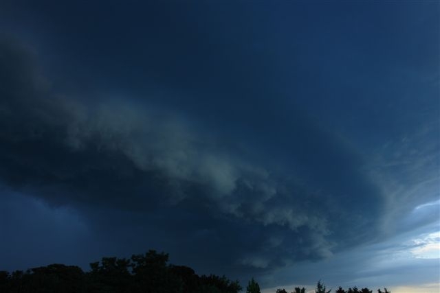
er gaat momenteel een supercel over noord-limburg... en het westen krijgt vanacht zeer zwaar weer..
'In de stad York zal plaatsvinden een ineenstorting, twee tweelingbroers uiteengerukt door chaos. Terwijl het fort valt zal de grote leider vallen.Derde grote oorlog zal beginnen als de grote stad brandt.'
De cel kwan net langs Venlo.... maar geen windhoos gezien.quote:Op dinsdag 12 augustus 2008 19:59 schreef kebabkever het volgende:
er gaat momenteel een supercel over noord-limburg... en het westen krijgt vanacht zeer zwaar weer..
Zal ff een paar foto's uploaden
<a href="http://www.vwkweb.nl/" rel="nofollow" target="_blank">[b]Vereniging voor weerkunde en klimatologie[/b]</a>
<a href="http://www.estofex.org/" rel="nofollow" target="_blank">[b]ESTOFEX[/b]</a>
<a href="http://www.estofex.org/" rel="nofollow" target="_blank">[b]ESTOFEX[/b]</a>

quote:Op dinsdag 12 augustus 2008 13:53 schreef IkWilbert het volgende:
update van estofex zojuist
[ afbeelding ]
[..]
♫


De supercel gezien van de achterkant

<a href="http://www.vwkweb.nl/" rel="nofollow" target="_blank">[b]Vereniging voor weerkunde en klimatologie[/b]</a>
<a href="http://www.estofex.org/" rel="nofollow" target="_blank">[b]ESTOFEX[/b]</a>
<a href="http://www.estofex.org/" rel="nofollow" target="_blank">[b]ESTOFEX[/b]</a>
nice piccaquote:Op dinsdag 12 augustus 2008 20:17 schreef -CRASH- het volgende:
De supercel gezien van de achterkant
[ afbeelding ]
Mooie foto.....quote:
Maar is ie op Mars of op Jupiter gemaakt
<a href="http://www.vwkweb.nl/" rel="nofollow" target="_blank">[b]Vereniging voor weerkunde en klimatologie[/b]</a>
<a href="http://www.estofex.org/" rel="nofollow" target="_blank">[b]ESTOFEX[/b]</a>
<a href="http://www.estofex.org/" rel="nofollow" target="_blank">[b]ESTOFEX[/b]</a>
De supercell kwam hier letterlijk tot het eind van de straat, 100 meter verderop zag ik de bomen niet meer van de slagregen terwijl ik gewoon buiten stond met een paar drupjes regen 
En die wolken aan de onderkant bewogen letterlijk in de zin van OMGWTFBBQ!!
Het was net een aflevering van stormchasers maar helaas moest ik ergens anders naartoe van de bui af
En die wolken aan de onderkant bewogen letterlijk in de zin van OMGWTFBBQ!!
Het was net een aflevering van stormchasers maar helaas moest ik ergens anders naartoe van de bui af
Vi är Borg. Motstånd är meningslöst. Ni kommer att bli assimilerade!!