WKN Weer, Klimaat en Natuurrampen
Lees alles over het onstuimige weer op onze planeet, volg orkanen en tornado's, zie hoe vulkanen uitbarsten en hoe Moeder Aarde beeft bij een aardbeving. Alles over de verwoestende kracht van onze planeet en tal van andere natuurverschijnselen.


Voorgaande topics
Aardbevingen #1
Aardbevingen #2
Aardbevingen #3
Aardbevingen #4
Aardbevingen #5
Samenvatting
Een aardbeving is een trilling of schokkende beweging van de aardkorst. Aardbevingen vinden plaats als er in de aardkorst plotseling veel energie vrijkomt. De energie plant zich dan in een golfbeweging vanuit het centrum naar de omgeving voort. Het denkbeeldige punt waar de beving ontstaat, het zwaartepunt van de energiedichtheid, heet het hypocentrum. Het punt aan het aardoppervlak daar loodrecht boven wordt het epicentrum genoemd. Een lijn van gelijke bevingintensiteit rond een epicentrum heet een isoseist. Seismologie is de wetenschap van aardbevingen.
De meeste aardbevingen komen voor in de aardkorst tot op een diepte van ongeveer 30 kilometer. Er komen echter ook bevingen voor op dieptes tot ongeveer 700 kilometer. De meeste aardbevingen komen voor rondom de Grote Oceaan, in het Middellandse Zeegebied, in de Himalaya en Indonesië. Ook midden in oceanen komen bevingen voor. Aardbevingen die ontstaan onder de zeespiegel worden, minder correct, ook wel zeebevingen genoemd; een vloedgolf of tsunami kan dan het gevolg zijn.
Veel aardbevingen hangen samen met de langzame interne bewegingen van de aardkorst. Op grote schaal kan het de aardschollen betreffen, die langzaam ten opzichte van elkaar bewegen (platentektoniek). Op kleinere schaal vindt er ook binnen de platen deformatie plaats.
Door deze relatieve beweging wordt spanning opgebouwd in de korst. Als de spanning hoog genoeg is kan er een schoksgewijze beweging van het materiaal aan weerszijden van een breuk in de korst optreden: de aardbeving. Hierbij wordt (een deel van) de opgebouwde spanning ontladen. Naschokken zijn kleinere bevingen die binnen enkele uren na de eerste beving voelbaar zijn. Deze zijn vaak het gevolg van spanningsontlading op andere, nabijgelegen delen van dezelfde breuk of op andere nabije breuken. Dit type aardbevingen komt binnen platen voor tot een diepte van enkele tientallen kilometers en aan plaatranden ook tot op grotere diepte.
Aardbevingen op dieptes van enkele honderden kilometers worden vaak toegeschreven aan andere mechanismen. Ten eerste kunnen deze worden veroorzaakt in een subducerende plaat door de overgang van mineralen van een fase naar de andere (zie convectie in de aarde). Wanneer de oude fase metastabiel was, kan de overgang naar de nieuwe fase zeer plotseling zijn. Op een vergelijkbare wijze kan het plotseling loslaten van water uit waterhoudende mineralen in de subducerende plaat een aardbeving veroorzaken.
Kleine aardbevingen zijn het gevolg van vulkanische activiteit (vulkanische aardbevingen) of ontstaan door instorting van holtes in kalksteenformaties of mijnen (instortingsbevingen). Mogelijke andere oorzaken zijn ondergrondse kernproeven en meteorietinslagen.
Menselijk ingrijpen kan bevingen veroorzaken. De bodemdaling door de winning van aardgas brengt aardschokken teweeg. Dit fenomeen doet zich onder meer voor in de provincie Groningen bij het dorp Loppersum.
Hoe ontstaan ze?
Een aardbeving is een trilling of schokkende beweging van de aardkorst. Aardbevingen worden veroorzaakt als er ergens in de aardkorst plotseling veel energie vrijkomt. Dit kan door bijvoorbeeld het langs elkaar heen schuiven van de aardschollen. (Platentektoniek genoemd) Of doordat aardschollen onder/over elkaar schuiven met brute kracht. De wrijving/spanning veroorzaakt dan een breuk/aardbeving.
Breuklijnen, Aardschollen
Op onderstaand plaatje kun je zien waar ter wereld de 'aardschollen' liggen. Op de grens van twee schollen komen dan ook de meeste aardbevingen ter wereld voor.
Eén van de bekendste breuken ter wereld is de San Andreas Faultline (=breuklijn) in Californie. Deze is ontstaan doordat de Pacifische Plaat langzaam langs/onder de Noord Amerikaanse plaat schuift.
Hoe worden ze gemeten?
Aardbevingen komen meestal voor op een diepte tussen de 0 en 30 km. Maar ze kunnen ook op 600 km diepte voorkomen. Het punt aan de aardkorst oppervlakte dat loodrecht boven de plek van de beving staat noemen we het "epicentrum" De bevingen worden in kaart gebracht mbv de "Schaal van Richter (Vernoemd naar de geoloog Francis Richter uit 1935).
De Richter schaal wordt gebruikt om de kracht van een aardbeving aan te geven. Het gaat daarbij om de hoeveelheid energie de vrijkomt tijdens de aardbeving. Op de Richter schaal wordt de kracht aangegeven met een getal. De Schaal van Richter is logaritmisch, dat wil zeggen dat de kracht van de aardbeving 10 keer zo groot is als het Richter getal met 1 toeneemt. Een aardbeving met kracht 6 is dus 10 keer zo zwaar als een aardbeving met kracht 5. Meer info over de richterschaal vind je o.a. in onderstaande links.
De twaalf sterkste aardbevingen sinds 1900 zijn:
De aardbeving die de meeste slachtoffers kostte was overigens veel lichter. In 1976 deed zich in China een aardbeving voor met een kracht van 8.0. Omdat het een zeer dicht bevolkt gebied was waren er ongeveer 250.000 doden te betreuren. Op 26 december 2004 vond een aardbeving plaats voor de kust van het Indonesische eiland Sumatra. Deze zeebeving had een kracht van 9.0 op de schaal van Richter. Er vielen echter slachtoffers in de hele regio Zuid-Oost Azië (India, Sri Lanka, Thailand, Indonesië zelf) als gevolg van de tsunami (vloedgolf) die volgde op de zeebeving. Waarschijnlijk zijn daar ook 200.000 slachtoffers gevallen. (In 2003 vielen bij een aardbeving in Iran meer dan 40.000 doden bij een beving in Bam van 6.2)
Aardbevingen? Ook in Nederland?
Ook in Nederland komen aardbevingen voor. In het zuidoosten worden elk jaar kleine aardbevingen gemeten met een kracht van 2 tot 3 op de schaal van Richter. Soms zijn er sterkere aardbevingen, zoals op 13 april 1992 in de buurt van Roermond met een kracht van 5.8 en in 2002 iets ten oosten van Roermond in Duitsland met een kracht van 4.9.
In Noord-Nederland komen, vooral in Groningen en Drenthe, lichte aardbevingen voor. Die worden naar alle waarschijnlijkheid veroorzaakt door de gaswinning uit de bodem, waardoor de aardbodem zakt. Op 24 oktober 2003 was er in de omgeving van Loppersum een lichte aardbeving met een kracht van 3.0. Het verslag van het KNMI over deze aardbeving vind je hier. In diezelfde omgeving vond ook op 22 september 2003 een (lichtere) aardbeving plaats, kracht 2.3.
Hoeveel aardbevingen vinden er plaats?
Het gemiddeld aantal bevingen per jaar met de bijbehorende magnitude (kracht) zijn:
-3000 met magnitude 5.0-5.9
-100 met magnitude 6.0-6.9
-20 met magnitude 7.0-7.9
-2 met magnitude 8.0 of meer
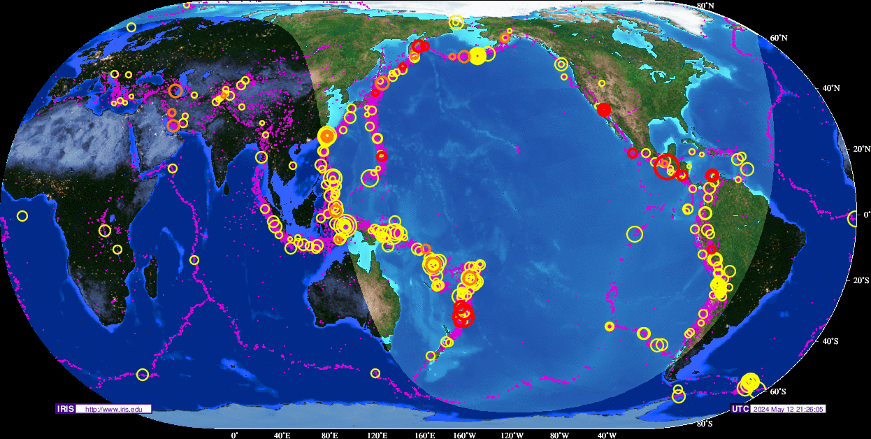
Dit plaatje geeft weer waar er aardbevingen zijn geweest tussen 1963 en 1998.
Dit plaatje geeft weer waar er aardbevingen zijn geweest tussen 1978 en 1987.
Tsunami's - een gevolg van een zeebeving
Sinds de catastrofale zeebeving op 2e kerstdag 2004 is het woord 'tsunami' niet meer weg te denken uit de woordenboeken. Wat is nou een Tsunami?
Alle gebeurtenissen waarmee een grote hoeveelheid water in korte tijd wordt verplaatst kunnen een tsunami veroorzaken. Vloedgolven kunnen veroorzaakt worden door een zeebeving, een aardbeving waarvan het epicentrum onder de zeespiegel ligt, door een meteoriet, of door een vulkanische uitbarsting onder zee of vlak aan zee, vooral als daarbij door een grote aardverschuiving veel gesteente de zee in schuift. Ook bij plotseling afkalven van een gletsjer of ijsberg kan een vloedgolf ontstaan. Ook kan het zo zijn dat er grote stukken land of gebergte het water invallen. Hierdoor ontstaan vaak kleinere tsunami's omdat er minder water wordt verplaatst.
De meeste tsunami's komen voor rondom de Grote Oceaan, omdat langs de randen daarvan door de platentektoniek de meeste aardbevingen plaatsvinden.
Door de verplaatsing van de zeebodem, vooral als deze kilometers diep plaatsvindt, wordt een enorme kolom water opgetild. Aan het wateroppervlak is daarvan weinig te zien, er ontstaat een golf van misschien een hoogte van enkele decimeters, met een enorme golflengte van 100 tot 400 kilometer. Door deze grote golflengte zijn er op volle zee maar enkele pieken en dalen merkbaar; op een schip zal de tsunami ongemerkt voorbij gaan. Een golf die door de wind wordt veroorzaakt kan weliswaar een veel grotere hoogte bereiken, tot 10 meter, bij een golflengte van 200 meter, maar de energie die in de tsunami is opgeslagen is veel groter. De waterbeweging vindt bij een tsunami plaats tot op de zeebodem, terwijl een golf door de wind slechts aan het oppervlak van de zee te merken is. Een normale golf bereikt een snelheid tot 40 km/uur, maar een tsunami kan zich met een veel hogere snelheid verplaatsen. De periode van de tsunami (het tijdsverloop tussen twee toppen) bedraagt een kwartier tot een uur.
Wat is GEE?
GEE betekent Global Earthquake Explorer. Het is een programma voor je desktop waar je live aardbevingen en data mee ontvangt.
Developer page
Download GEE
Screenshots
Naslagwerken / Informatie / Nuttige Links / Sites
Aardbevingen
Nederlandse Aardbevingsite
US Geological Survey Website
WikiPedia Aardbeving
Natuurrampen pagina
Stan's Earthquake Warnings
Aardbevingsdossier Kennislink
Tsunami's
WikiPedia Tsunami
Tsunamidossier Kennislink
Wiki Dossier Tsunami Ramp Azie 2004
Deze op is te vinden in de FOK!Wiki:
Fok!Wiki OP/Aardbevingen
[ Bericht 49% gewijzigd door Frutsel op 30-11-2007 09:18:49 ]
Samenvatting
Een aardbeving is een trilling of schokkende beweging van de aardkorst. Aardbevingen vinden plaats als er in de aardkorst plotseling veel energie vrijkomt. De energie plant zich dan in een golfbeweging vanuit het centrum naar de omgeving voort. Het denkbeeldige punt waar de beving ontstaat, het zwaartepunt van de energiedichtheid, heet het hypocentrum. Het punt aan het aardoppervlak daar loodrecht boven wordt het epicentrum genoemd. Een lijn van gelijke bevingintensiteit rond een epicentrum heet een isoseist. Seismologie is de wetenschap van aardbevingen.
De meeste aardbevingen komen voor in de aardkorst tot op een diepte van ongeveer 30 kilometer. Er komen echter ook bevingen voor op dieptes tot ongeveer 700 kilometer. De meeste aardbevingen komen voor rondom de Grote Oceaan, in het Middellandse Zeegebied, in de Himalaya en Indonesië. Ook midden in oceanen komen bevingen voor. Aardbevingen die ontstaan onder de zeespiegel worden, minder correct, ook wel zeebevingen genoemd; een vloedgolf of tsunami kan dan het gevolg zijn.
Veel aardbevingen hangen samen met de langzame interne bewegingen van de aardkorst. Op grote schaal kan het de aardschollen betreffen, die langzaam ten opzichte van elkaar bewegen (platentektoniek). Op kleinere schaal vindt er ook binnen de platen deformatie plaats.
Door deze relatieve beweging wordt spanning opgebouwd in de korst. Als de spanning hoog genoeg is kan er een schoksgewijze beweging van het materiaal aan weerszijden van een breuk in de korst optreden: de aardbeving. Hierbij wordt (een deel van) de opgebouwde spanning ontladen. Naschokken zijn kleinere bevingen die binnen enkele uren na de eerste beving voelbaar zijn. Deze zijn vaak het gevolg van spanningsontlading op andere, nabijgelegen delen van dezelfde breuk of op andere nabije breuken. Dit type aardbevingen komt binnen platen voor tot een diepte van enkele tientallen kilometers en aan plaatranden ook tot op grotere diepte.
Aardbevingen op dieptes van enkele honderden kilometers worden vaak toegeschreven aan andere mechanismen. Ten eerste kunnen deze worden veroorzaakt in een subducerende plaat door de overgang van mineralen van een fase naar de andere (zie convectie in de aarde). Wanneer de oude fase metastabiel was, kan de overgang naar de nieuwe fase zeer plotseling zijn. Op een vergelijkbare wijze kan het plotseling loslaten van water uit waterhoudende mineralen in de subducerende plaat een aardbeving veroorzaken.
Kleine aardbevingen zijn het gevolg van vulkanische activiteit (vulkanische aardbevingen) of ontstaan door instorting van holtes in kalksteenformaties of mijnen (instortingsbevingen). Mogelijke andere oorzaken zijn ondergrondse kernproeven en meteorietinslagen.
Menselijk ingrijpen kan bevingen veroorzaken. De bodemdaling door de winning van aardgas brengt aardschokken teweeg. Dit fenomeen doet zich onder meer voor in de provincie Groningen bij het dorp Loppersum.
Hoe ontstaan ze?
Een aardbeving is een trilling of schokkende beweging van de aardkorst. Aardbevingen worden veroorzaakt als er ergens in de aardkorst plotseling veel energie vrijkomt. Dit kan door bijvoorbeeld het langs elkaar heen schuiven van de aardschollen. (Platentektoniek genoemd) Of doordat aardschollen onder/over elkaar schuiven met brute kracht. De wrijving/spanning veroorzaakt dan een breuk/aardbeving.
Breuklijnen, Aardschollen
Op onderstaand plaatje kun je zien waar ter wereld de 'aardschollen' liggen. Op de grens van twee schollen komen dan ook de meeste aardbevingen ter wereld voor.

Eén van de bekendste breuken ter wereld is de San Andreas Faultline (=breuklijn) in Californie. Deze is ontstaan doordat de Pacifische Plaat langzaam langs/onder de Noord Amerikaanse plaat schuift.

Hoe worden ze gemeten?
Aardbevingen komen meestal voor op een diepte tussen de 0 en 30 km. Maar ze kunnen ook op 600 km diepte voorkomen. Het punt aan de aardkorst oppervlakte dat loodrecht boven de plek van de beving staat noemen we het "epicentrum" De bevingen worden in kaart gebracht mbv de "Schaal van Richter (Vernoemd naar de geoloog Francis Richter uit 1935).
De Richter schaal wordt gebruikt om de kracht van een aardbeving aan te geven. Het gaat daarbij om de hoeveelheid energie de vrijkomt tijdens de aardbeving. Op de Richter schaal wordt de kracht aangegeven met een getal. De Schaal van Richter is logaritmisch, dat wil zeggen dat de kracht van de aardbeving 10 keer zo groot is als het Richter getal met 1 toeneemt. Een aardbeving met kracht 6 is dus 10 keer zo zwaar als een aardbeving met kracht 5. Meer info over de richterschaal vind je o.a. in onderstaande links.
De twaalf sterkste aardbevingen sinds 1900 zijn:

| 1 2 3 4 5 6 7 8 9 10 11 12 13 | 1. Chile 22-mei-1960 9.5 2. Prince William Sound, Alaska 28-mrt-1964 9.2 3. Off W. Coast of N. Sumatra 26-dec-2004 9.1 4. Kamchatka 04-nov-1952 9.0 5. Off the Coast of Ecuador 31-jan-1906 8.8 6. Rat Islands, Alaska 04-feb-1965 8.7 7. Northern Sumatra, Indonesia 28-maa-2005 8.6 8. Andreanof Islands, Alaska 09-maa-1957 8.6 9. Assam - Tibet 15-aug-1950 8.6 10. Kuril Islands 13-okt-1963 8.5 11. Banda Sea, Indonesia 01-feb-1938 8.5 12. Kamchatka 03-feb-1923 8.5 |
De aardbeving die de meeste slachtoffers kostte was overigens veel lichter. In 1976 deed zich in China een aardbeving voor met een kracht van 8.0. Omdat het een zeer dicht bevolkt gebied was waren er ongeveer 250.000 doden te betreuren. Op 26 december 2004 vond een aardbeving plaats voor de kust van het Indonesische eiland Sumatra. Deze zeebeving had een kracht van 9.0 op de schaal van Richter. Er vielen echter slachtoffers in de hele regio Zuid-Oost Azië (India, Sri Lanka, Thailand, Indonesië zelf) als gevolg van de tsunami (vloedgolf) die volgde op de zeebeving. Waarschijnlijk zijn daar ook 200.000 slachtoffers gevallen. (In 2003 vielen bij een aardbeving in Iran meer dan 40.000 doden bij een beving in Bam van 6.2)
Aardbevingen? Ook in Nederland?
Ook in Nederland komen aardbevingen voor. In het zuidoosten worden elk jaar kleine aardbevingen gemeten met een kracht van 2 tot 3 op de schaal van Richter. Soms zijn er sterkere aardbevingen, zoals op 13 april 1992 in de buurt van Roermond met een kracht van 5.8 en in 2002 iets ten oosten van Roermond in Duitsland met een kracht van 4.9.
In Noord-Nederland komen, vooral in Groningen en Drenthe, lichte aardbevingen voor. Die worden naar alle waarschijnlijkheid veroorzaakt door de gaswinning uit de bodem, waardoor de aardbodem zakt. Op 24 oktober 2003 was er in de omgeving van Loppersum een lichte aardbeving met een kracht van 3.0. Het verslag van het KNMI over deze aardbeving vind je hier. In diezelfde omgeving vond ook op 22 september 2003 een (lichtere) aardbeving plaats, kracht 2.3.
Hoeveel aardbevingen vinden er plaats?
Het gemiddeld aantal bevingen per jaar met de bijbehorende magnitude (kracht) zijn:
-3000 met magnitude 5.0-5.9
-100 met magnitude 6.0-6.9
-20 met magnitude 7.0-7.9
-2 met magnitude 8.0 of meer
Tsunami's - een gevolg van een zeebeving
Sinds de catastrofale zeebeving op 2e kerstdag 2004 is het woord 'tsunami' niet meer weg te denken uit de woordenboeken. Wat is nou een Tsunami?
Alle gebeurtenissen waarmee een grote hoeveelheid water in korte tijd wordt verplaatst kunnen een tsunami veroorzaken. Vloedgolven kunnen veroorzaakt worden door een zeebeving, een aardbeving waarvan het epicentrum onder de zeespiegel ligt, door een meteoriet, of door een vulkanische uitbarsting onder zee of vlak aan zee, vooral als daarbij door een grote aardverschuiving veel gesteente de zee in schuift. Ook bij plotseling afkalven van een gletsjer of ijsberg kan een vloedgolf ontstaan. Ook kan het zo zijn dat er grote stukken land of gebergte het water invallen. Hierdoor ontstaan vaak kleinere tsunami's omdat er minder water wordt verplaatst.
De meeste tsunami's komen voor rondom de Grote Oceaan, omdat langs de randen daarvan door de platentektoniek de meeste aardbevingen plaatsvinden.

Door de verplaatsing van de zeebodem, vooral als deze kilometers diep plaatsvindt, wordt een enorme kolom water opgetild. Aan het wateroppervlak is daarvan weinig te zien, er ontstaat een golf van misschien een hoogte van enkele decimeters, met een enorme golflengte van 100 tot 400 kilometer. Door deze grote golflengte zijn er op volle zee maar enkele pieken en dalen merkbaar; op een schip zal de tsunami ongemerkt voorbij gaan. Een golf die door de wind wordt veroorzaakt kan weliswaar een veel grotere hoogte bereiken, tot 10 meter, bij een golflengte van 200 meter, maar de energie die in de tsunami is opgeslagen is veel groter. De waterbeweging vindt bij een tsunami plaats tot op de zeebodem, terwijl een golf door de wind slechts aan het oppervlak van de zee te merken is. Een normale golf bereikt een snelheid tot 40 km/uur, maar een tsunami kan zich met een veel hogere snelheid verplaatsen. De periode van de tsunami (het tijdsverloop tussen twee toppen) bedraagt een kwartier tot een uur.
Wat is GEE?
GEE betekent Global Earthquake Explorer. Het is een programma voor je desktop waar je live aardbevingen en data mee ontvangt.
Naslagwerken / Informatie / Nuttige Links / Sites
Aardbevingen
Tsunami's
Deze op is te vinden in de FOK!Wiki:
[ Bericht 49% gewijzigd door Frutsel op 30-11-2007 09:18:49 ]
en er is al een 9.1 geweest enkele jaren geleden, ook niet onbelangrijk, hoewel een stuk naar het noordwesten.quote:Op vrijdag 14 september 2007 20:51 schreef Againzender het volgende:
Er wordt in dat soort zones altijd gewacht op 'die ene grote'. Maar als je met aardschokken van 8.2, en daarna nog zware naschokken komt, vraag ik mij af of je dan niet met die grote te maken hebt.
Maar goed, feit blijft dat de aarde erg onrustig is daar, die grote knal heeft alles gedestabiliseerd lijkt het.
National cheographic en discovery maken vaak van die docu's met supervulkanen en mega aardbevingen. Vaak zijn het herhalingen, maar ook vaak erg 'het zou kunnen' scenario's.
Kein gewalt! Wir sind das volk!
Steps taken forwards but sleepwalking back again.
''And the Germans kill the Jews, And the Jews kill the Arabs, And the Arabs kill the hostages
And that is the news.''
Steps taken forwards but sleepwalking back again.
''And the Germans kill the Jews, And the Jews kill the Arabs, And the Arabs kill the hostages
And that is the news.''
Ik heb eergisteren de BBC serie 'Krakatoa, the last days' gekocht. Erg boeiend en komt ook op Discovery voorbij hier in Azie.
ik heb laatst 'Supervolcano' gekocht van BBC, iets mindere graphics maar desondanks erg interessant. Docu over Yellowstone Parkquote:Op zaterdag 15 september 2007 13:46 schreef indahnesia.com het volgende:
Ik heb eergisteren de BBC serie 'Krakatoa, the last days' gekocht. Erg boeiend en komt ook op Discovery voorbij hier in Azie.
Krakatoa en Supervolcano heb ik beide gezien, erg interessante BBC-docu's
Zie ook -> National Geographic: PLANET EARTH in SEPT/OKT en [Films/Docu's/Boeken] Over onze planeet
Zie ook -> National Geographic: PLANET EARTH in SEPT/OKT en [Films/Docu's/Boeken] Over onze planeet
Dodental aardbevingen Indonesië stijgt iets
JAKARTA - Op Sumatra zijn als gevolg van de zeer krachtige aardbeving van afgelopen woensdag 23 mensen om het leven gekomen.
Dit heeft het Indonesische ministerie van Volksgezondheid zaterdag bekendgemaakt. Veertien doden vielen in Bengkulu, een West-Sumatraanse kustplaats die niet ver van het epicentrum lag.
De schade in de streek is volgens zegslieden gigantisch. Naars schatting 5000 huizen zijn volledig verwoest en 13.000 huizen zijn beschadigd net als achthonderd scholen, 75 moskeeën en een honderdtal kantoren of overheidgebouwen.
De aardbeving van woensdag was onder de zeebodem en had een kracht van 8,4 op de schaal van Richter. De beving werd gevolgd door een serie zeer zware naschokken
Typisch dat het woord 'moskee' in de Nederlandse vertaling voorkomt. Hier in Indonesie is het altijd een 'gebedshuis', en daaronder zijn ook zeker kerken.
Ik doe ook een duit in het zakje
Indonesia's big one 'on its way'
Story Highlights
# Experts: 3 major quakes in past week increase chance of major disaster
# On the equator, Sumatra holds the deadliest stretch of ocean in the world
# Driven by the plate beneath the Indian Ocean, the entire coastline is flexing
Indonesia's big one 'on its way'
Story Highlights
# Experts: 3 major quakes in past week increase chance of major disaster
# On the equator, Sumatra holds the deadliest stretch of ocean in the world
# Driven by the plate beneath the Indian Ocean, the entire coastline is flexing

Er zijn volgens BMG (het lokale KNMI hier) al meer dan 140 schokken geweest in het gebied. Deze 6.1 is wel weer vrij stevig idd.
zal straks wel weer geupgrade wordenquote:Op woensdag 19 september 2007 10:27 schreef indahnesia.com het volgende:
Hier krijg ik hem door als en 6.4 trouwens. (niet via USGS)

Hm, onprettig idee. Het blijft inderdaad maar rommelen daar.quote:Op dinsdag 18 september 2007 11:19 schreef indahnesia.com het volgende:
Ik doe ook een duit in het zakje
Indonesia's big one 'on its way'
Story Highlights
# Experts: 3 major quakes in past week increase chance of major disaster
# On the equator, Sumatra holds the deadliest stretch of ocean in the world
# Driven by the plate beneath the Indian Ocean, the entire coastline is flexing
[b]Op maandag 6 september 2010 00:28 schreef tong80 het volgende:[/b]
GVD Wat moet jij een trotse vader zijn :)
:P
GVD Wat moet jij een trotse vader zijn :)
:P
onprettig inderdaad, maar het is maar beter het te weten zodat men in ieder geval de goeie kant op rent als er een nieuwe golf aan komt.

laat me met rust!quote:Op donderdag 20 september 2007 10:58 schreef Frutsel het volgende:
En nog een flinke zojuist...voorlopige rapport gaat uit van een 6.6
[afbeelding]
Halfuurtje geleden:
quote:MAP 5.8 2007/09/23 14:13:42 -2.151 99.878 14.0 KEPULAUAN MENTAWAI REGION, INDONESIA

wat is je schoolopdracht?quote:Op maandag 24 september 2007 11:31 schreef Crientj het volgende:
Terugvindertje, kan het dan iets makkelijker terugvinden voor mn schoolopdracht.
Maar nog geen melding/bevestiging @ usgs .quote:BreakingNewsOn: BREAKING NEWS -- MASSIVE EARTHQUAKE STRIKES NEW IRELAND REGION. DETAILS SOON. -- BREAKING NEWS

Twitter via de mail . Zag 't toevallig.quote:Op woensdag 26 september 2007 15:14 schreef Frutsel het volgende:
Hoe was je zo snel Roel? Twitter? Zit je dat te F5'en of is dat met een popup?
Ah dan krijg je heel wat mails nuquote:Op woensdag 26 september 2007 15:18 schreef Roel_Jewel het volgende:
[..]
Twitter via de mail . Zag 't toevallig.
Tsunami waarschuwing - Breaking News -
Overal rinkelt wat, maar er wordt geen 'vierkantje' ingevuld bij USGS
=========================================================
TSUNAMI INFORMATION STATEMENT NUMBER 1
NWS PACIFIC TSUNAMI WARNING CENTER EWA BEACH HI
253 AM HST WED SEP 26 2007
TO - CIVIL DEFENSE IN THE STATE OF HAWAII
SUBJECT - TSUNAMI INFORMATION
THIS STATEMENT IS FOR INFORMATION ONLY. NO ACTION REQUIRED.
AN EARTHQUAKE HAS OCCURRED WITH THESE PRELIMINARY PARAMETERS
ORIGIN TIME - 0236 AM HST 26 SEP 2007
COORDINATES - 5.0 SOUTH 153.2 EAST
LOCATION - NEW IRELAND REGION P.N.G.
MAGNITUDE - 6.9 MOMENT
EVALUATION
BASED ON ALL AVAILABLE DATA A DESTRUCTIVE PACIFIC-WIDE TSUNAMI IS
NOT EXPECTED AND THERE IS NO TSUNAMI THREAT TO HAWAII. REPEAT. A
DESTRUCTIVE PACIFIC-WIDE TSUNAMI IS NOT EXPECTED AND THERE IS NO
TSUNAMI THREAT TO HAWAII.
THIS WILL BE THE ONLY STATEMENT ISSUED FOR THIS EVENT UNLESS
ADDITIONAL DATA ARE RECEIVED.
2 over de beving iigquote:Op woensdag 26 september 2007 15:21 schreef Frutsel het volgende:
[..]
Ah dan krijg je heel wat mails nu
3:13 PM BreakingNewsOn: BREAKING NEWS -- PACIFIC TSUNAMI WARNING CENTER: EARTHQUAKE MAY GENERATE LOCAL TSUNAMIS WHICH MAY BE DESTRUCTIVE NEAR THE EPICENTER.
http://edition.cnn.com/20(...).quake.ap/index.html
quote:Quakes strike near New Caledonia
NOUMEA, New Caledonia (AP) -- A series of earthquakes struck near the French islands of New Caledonia in the South Pacific on Friday, prompting increased vigilance for a tsunami, though officials said there was no immediate risk.
About 15 quakes hit the region and some ranged in magnitude from 5.0 to 6.6, the U.S. Geological Survey said. The quakes struck around midday local time and most were centered in a region about 100 miles east of New Caledonia's Loyalty Islands, it said.
There were no reports of injuries or damage in the sparsely populated atolls nearest the epicenter, said Capt. Jean-Christian Baratto, an official with the French High Commissariat in New Caledonia.
He said residents of Maree Island, the closest to the epicenter, felt only "slight shaking."
Stuart Koyanagi, a geophysicist with the Pacific Tsunami Warning Center in Hawaii, said the quakes were too small to generate a Pacific-wide tsunami.
While the center warned that the largest of the quakes had the potential to generate a local tsunami, Baratto dismissed that possibility.
"We are watching carefully. There is no risk of a local tsunami," he said.
The French High Commissariat in New Caledonia convened an urgent meeting to discuss the quakes. Local police were warned to stay "vigilant," the commissariat said.
New Caledonia is a collection of small islands with a population of about 221,000 people located some 1,120 miles northeast of Australia. It lies along the Pacific Basin's so-called "Ring of Fire," an arc of volcanoes and fault lines where quakes are frequent.
The quakes came soon as New Caledonia is testing a new tsunami warning system, Baratto said. The system includes text messages that would be sent to cell phones in the case of a tsunami risk.
'Fijne' reeks
quote:MAP 5.2 2007/09/28 02:20:04 -21.352 169.472 10.0 SOUTHEAST OF THE LOYALTY ISLANDS
MAP 5.0 2007/09/28 02:01:34 -21.206 169.304 10.0 SOUTHEAST OF THE LOYALTY ISLANDS
MAP 5.3 2007/09/28 01:51:00 -21.287 169.434 10.0 SOUTHEAST OF THE LOYALTY ISLANDS
MAP 5.5 2007/09/28 01:43:57 -23.652 169.300 10.0 SOUTHEAST OF THE LOYALTY ISLANDS
MAP 6.6 2007/09/28 01:35:52 -21.255 169.412 10.0 SOUTHEAST OF THE LOYALTY ISLANDS
MAP 5.6 2007/09/28 01:25:16 -21.293 169.499 10.0 SOUTHEAST OF THE LOYALTY ISLANDS
MAP 6.4 2007/09/28 01:01:49 -21.442 169.368 10.0 SOUTHEAST OF THE LOYALTY ISLANDS
MAP 5.9 2007/09/28 00:44:48 -21.376 169.230 10.0 SOUTHEAST OF THE LOYALTY ISLANDS
MAP 4.9 2007/09/27 22:10:11 -21.187 169.235 10.0 SOUTHEAST OF THE LOYALTY ISLANDS
MAP 5.4 2007/09/27 22:01:13 -21.266 169.375 10.0 SOUTHEAST OF THE LOYALTY ISLANDS
MAP 5.3 2007/09/27 21:26:58 -21.219 169.216 10.0 SOUTHEAST OF THE LOYALTY ISLANDS
MAP 5.5 2007/09/27 21:05:35 -21.202 169.343 15.4 SOUTHEAST OF THE LOYALTY ISLANDS
MAP 5.0 2007/09/27 21:02:05 -21.362 169.496 10.0 SOUTHEAST OF THE LOYALTY ISLANDS
MAP 5.4 2007/09/27 20:47:20 -21.208 169.274 10.0 SOUTHEAST OF THE LOYALTY ISLANDS
MAP 5.2 2007/09/27 20:25:59 -21.205 169.304 10.0 SOUTHEAST OF THE LOYALTY ISLANDS
MAP 6.3 2007/09/27 19:57:45 -21.278 169.366 21.1 SOUTHEAST OF THE LOYALTY ISLANDS
En nog 2:
quote:MAP 6.0 2007/09/28 11:16:39 -21.519 169.217 10.0 SOUTHEAST OF THE LOYALTY ISLANDS
MAP 6.0 2007/09/28 11:12:41 -21.377 169.202 10.0 SOUTHEAST OF THE LOYALTY ISLANDS
Pacific Tsunami Warning Center: Strong quake measuring at least 7.4 struck at a depth of 276km. -- JUST IN
Stevige zeebeving die van 7.4quote:Op vrijdag 28 september 2007 16:24 schreef NewsMann het volgende:
Pacific Tsunami Warning Center: Strong quake measuring at least 7.4 struck at a depth of 276km. -- JUST IN
Maar gelukkig te diep om een tsunamie te kunnen veroorzaken
Huidige trend atmosf. CO2 Mauna Loa: 411 ppm ,10 jaar geleden: 387 ppm , 25 jaar geleden: 358 ppm
weer meerdere 6+ en een 7+.
Als aardbeving tel je de laatste tijd bijna niet meer mee als een dikke 6+.
Als aardbeving tel je de laatste tijd bijna niet meer mee als een dikke 6+.
Kein gewalt! Wir sind das volk!
Steps taken forwards but sleepwalking back again.
''And the Germans kill the Jews, And the Jews kill the Arabs, And the Arabs kill the hostages
And that is the news.''
Steps taken forwards but sleepwalking back again.
''And the Germans kill the Jews, And the Jews kill the Arabs, And the Arabs kill the hostages
And that is the news.''

6.8 zojuist op het zuidelijk eiland van Nieuw Zeeland
http://earthquake.usgs.go(...)uakes/us2007imal.php
http://earthquake.usgs.go(...)uakes/us2007imal.php
major earthquake in Israel "soon"
http://www.ynetnews.com/articles/0,7340,L-3459638,00.html
Staat niet bij wat "soon" is
http://www.ynetnews.com/articles/0,7340,L-3459638,00.html
Staat niet bij wat "soon" is
Da's vast als Iran overvliegt en iets laat vallen vanuit een vliegtuig...quote:Op maandag 15 oktober 2007 21:51 schreef Frutsel het volgende:
major earthquake in Israel "soon"
http://www.ynetnews.com/articles/0,7340,L-3459638,00.html
Staat niet bij wat "soon" is