WKN Weer, Klimaat en Natuurrampen
Lees alles over het onstuimige weer op onze planeet, volg orkanen en tornado's, zie hoe vulkanen uitbarsten en hoe Moeder Aarde beeft bij een aardbeving. Alles over de verwoestende kracht van onze planeet en tal van andere natuurverschijnselen.


CAMP SPRINGS, Maryland, - On the heels of El Niño, its opposite, the cooling weather pattern in the east-central equatorial Pacific known as La Niña is expected to arrive soon, according to government forecasters. La Niña conditions in the Pacific typically mean a greater than normal number of Atlantic hurricanes.
Photo: Dolphins play in the eastern tropical Pacific Ocean. (Photo courtesy NOAA)
In a weekly update, scientists at the NOAA Climate Prediction Center said that as the 2006-2007 El Niño has faded, surface and subsurface ocean temperatures have rapidly decreased.
Recently, cooler than normal water temperatures have developed at the surface in the east-central equatorial Pacific, indicating a possible transition to La Niña conditions.
La Niña conditions occur when ocean surface temperatures in the central and east-central equatorial Pacific become cooler than normal.
These changes affect tropical rainfall patterns and atmospheric winds over the Pacific Ocean, which influence the patterns of rainfall and temperatures in many areas worldwide.
Typically, across the United States during the spring and summer months, La Niña conditions do not significantly impact overall inland temperature and precipitation patterns,but La Niña episodes often do have an effect on Atlantic and Pacific hurricane activity.
"Although other scientific factors affect the frequency of hurricanes, there tends to be a greater than normal number of Atlantic hurricanes and fewer than normal number of eastern Pacific hurricanes during La Niña events," said NOAA Administrator Conrad Lautenbacher.
"During the winter, usual La Niña impacts include drier and warmer than average conditions over the southern United States," he said.
"NOAA's ability to detect and monitor the formation, duration and strength of El Niño and La Niña events is enhanced by continuous improvements in satellite and buoy observations in the equatorial Pacific," Lautenbacher explained.
The observing systems currently at work include the TAO/TRITON moored and Argo drift buoys, as well as NOAA's polar orbiting satellites.
"La Niña events sometimes follow on the heels of El Niño conditions," said Vernon Kousky, research meteorologist at the NOAA Climate Prediction Center. "It is a naturally occurring phenomenon that can last up to three years."
"While the status of El Niño/La Niña is of vital importance to our seasonal forecasts, it is but one measure we use when making actual temperature and precipitation forecasts," said Kousky.
La Niña episodes tend to develop during the four months from March through June, reach peak intensity during the December to February period, and then weaken during the following March to May period.
"The last lengthy La Niña event was 1998-2001, which contributed to serious drought conditions in many sections of the western United States," said Douglas Lecomte, drought specialist at the NOAA Climate Prediction Center.
In addition, atmospheric scientists have uncovered fresh evidence to support the controversial theory that global warming has contributed to the emergence of stronger hurricanes in the Atlantic Ocean.
Scientists at the University of Wisconsin-Madison and NOAA's National Climatic Data Center report that all the physical variables that converge to form hurricanes - wind speeds, wind directions and temperatures - feed off each other in ways that only make conditions more ripe for a storm.
The unsettling trend is confined to the Atlantic and does not hold up in any of the world's other oceans, researchers have also found.
James Kossin, a research scientist at UW-Madison's Cooperative Institute for Meteorological Satellite Studies, says the pattern emerged from a new dataset that correlates a variety of different satellite data over 22 years from 1983 to 2005.
"While we can see a correlation between global warming and hurricane strength, we still need to understand exactly why the Atlantic is reacting to warmer temperatures in this way, and that is much more difficult to do," says Kossin. "We need to be creating models and simulations to understand what is really happening here."
NOAA will issue the U.S. Spring Outlook on March 15, and its Atlantic Hurricane Season Outlook in May. Both outlooks will reflect the most current La Niña forecast.

Krijgt Madagascar nu twee stormen tegelijk voor de kiezen?
Formation
Indlala
==============
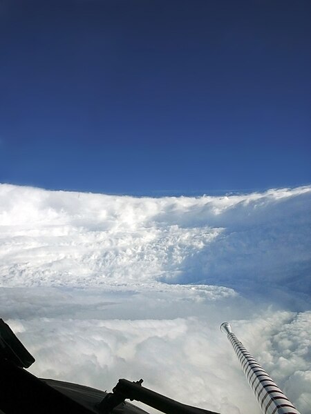
en nog even een prachtige foto van de "eyewall" van Hurricane Katrina
Formation

Indlala

==============
en nog even een prachtige foto van de "eyewall" van Hurricane Katrina
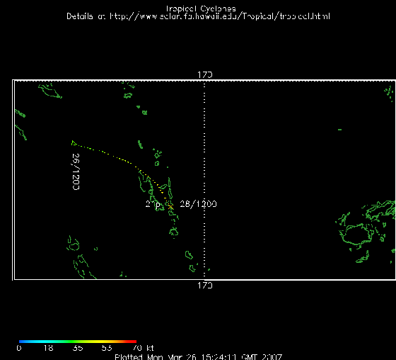
Hier trouwens een prachtige 'gif' van beide stormen voor de kust van Madagascar.. .jammer dat ik hem hier niet kan laten zien...
http://cimss.ssec.wisc.ed(...)an/visirjava19S.html
http://cimss.ssec.wisc.ed(...)an/visirjava19S.html

Mooi om te zien.quote:Op dinsdag 13 maart 2007 23:22 schreef Frutsel het volgende:
Hier trouwens een prachtige 'gif' van beide stormen voor de kust van Madagascar.. .jammer dat ik hem hier niet kan laten zien...
http://cimss.ssec.wisc.ed(...)an/visirjava19S.html
Alles kanquote:Op dinsdag 13 maart 2007 23:22 schreef Frutsel het volgende:
Hier trouwens een prachtige 'gif' van beide stormen voor de kust van Madagascar.. .jammer dat ik hem hier niet kan laten zien...
http://cimss.ssec.wisc.ed(...)an/visirjava19S.html

<a href="https://www.youtube.com/channel/UCPueUwKfPaGH7v48LZlltkg" rel="nofollow" target="_blank">WSDokkum Youtube</a>
Slachtoffer orkaan Rita nu pas gevonden
In een huis in de Amerikaanse plaats Beaumont zijn na anderhalf jaar de resten van een slachtoffer van de orkaan Rita gevonden.
De man lag gewoon in zijn bed. Zijn huis was vrijwel niet beschadigd, maar er was sinds de verwoestende orkaan niemand binnen geweest omdat er twee grote bomen voor de ingang lagen.
De 51-jarige Texaan leefde een kluizenaarsbestaan. Buren namen aan dat de man was gevlucht voor Rita en de hulpdiensten controleerden alleen woningen die schade hadden opgelopen door de orkaan.

Cycloon Indlala op weg naar Madagaskar
De krachtige cycloon Indlala ligt momenteel voor de noordoostkust van Madagaskar. De windsnelheden komen overeen met een orkaan van de 2e categorie op de schaal van Saffir-Simpson. De cycloon trekt nu over water met een temperatuur van ruim 27 graden, en zal naar verwachting nog wat verder uitdiepen. Morgen kan het schiereiland Masoala bereikt worden.
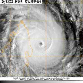
De krachtige cycloon Indlala ligt momenteel voor de noordoostkust van Madagaskar. De windsnelheden komen overeen met een orkaan van de 2e categorie op de schaal van Saffir-Simpson. De cycloon trekt nu over water met een temperatuur van ruim 27 graden, en zal naar verwachting nog wat verder uitdiepen. Morgen kan het schiereiland Masoala bereikt worden.
Hij blijft daar gewoon bij, maar kan wel even kijken wat ik kan doenquote:Op woensdag 14 maart 2007 08:13 schreef Frutsel het volgende:
Kewl Speedy!
Houdt hij die ook automatisch up-to-date of is en blijft dit die ene momentopname?
Hmmz nee dus, niks aan te doen
<a href="https://www.youtube.com/channel/UCPueUwKfPaGH7v48LZlltkg" rel="nofollow" target="_blank">WSDokkum Youtube</a>
Warmer klimaat zorgt nog niet voor meer cyclonen
Er zijn geen aanwijzingen dat de intensiteit van tropische cyclonen wereldwijd toeneemt. Alleen boven de Atlantische Oceaan is een lichte stijging zichtbaar, maar daar ontstaan maar 15 procent van alle cyclonen. Daarom staat niet vast dat er een verband is tussen opwarmend zeewater en zwaardere cyclonen. Amerikaanse onderzoekers, aangevoerd door James Kossin, meldden dit in Geophysical Research Letters.
Trends in cycloon-intensiteit kunnen worden afgeleid uit infrarood-opnames die satellieten sinds de jaren zeventig maken, maar de kwaliteit van de opnames veranderden sterk. Kossin schoonde oude analyses op en zag dat de intensiteit van cyclonen boven de Indische en Grote Oceaan is overschat. Het IPCC maakte in zijn laatste klimaatrapport al een voorbehoud.
Klimaatnieuws
George and Jacob flood North West Australia
In the course of a week, the northern coast of Western Australia went from dry desert to riverine landscape under the onslaught of two successive tropical cyclones. Powerful Cyclone George roared ashore on March 8, 2007, with winds gusting up to 275 kilometers per hour (170 miles per hour). The storm caused extensive damage, including three deaths, reported the Australia Broadcasting Corporation News. The much weaker Cyclone Jacob came ashore just east of George’s landing point on March 12. The top image, captured on March 13, by the Moderate Resolution Imaging Spectroradiometer (MODIS) on NASA’s Terra satellite, shows the cumulative impact of the two storms on the DeGrey River basin.
The DeGrey River flows west through Western Australia before it turns north to empty into the Indian Ocean at Poissonnier Point east of the city of Port Hedland, the city most severely damaged by Cyclone George. On March 6, before both storms struck, the river was barely distinguishable in MODIS imagery. One week later, the river and its many tributaries cut a tangle of blue across the landscape. The heavy rain brought by the storms has also prompted plant growth. The land has gone from desert pink—the color of bare or sparsely vegetated land in this type of image—to the bright green of plant-covered land. The images were made with both infrared and visible light to highlight the presence of water on the ground. In this type of image, water is black or dark blue, where tainted with sediment, and clouds are pale blue and white.

Cyclone Indlala came ashore on the island of Madagascar on March 15, 2007, as a Category 3 storm, according to data provided by the Joint Typhoon Warning Center. The storm was the country’s sixth hit of the 2006-2007 storm season. This image from the Moderate Resolution Imaging Spectroradiometer (MODIS) on NASA’s Terra satellite shows Indlala draped over the northern part of the island. Bands of swirling clouds spiral around the eye of the storm.
According to Reuters AlertNet news service, Madagascar’s emergency response resources were taxed to their limit in early March 2007 as a result of extensive flooding in the North, drought and food shortages in the South, and three previous hits from cyclones in the preceding few months: Bondo in December 2006, Clovis in January 2007, and Gamede in February. The arrival of Indlala interrupted emergency relief efforts and worsened an already difficult situation.
Forecasters: Active Atlantic Season
MIAMI (Reuters) - The Atlantic hurricane season will be exceptionally active this year, according to a British forecasting group, raising the possibility that killer storms like Hurricane Katrina could again threaten the United States.
London-based forecaster Tropical Storm Risk on Tuesday said the six-month season, which begins on June 1, was expected to bring 17 tropical storms, of which nine will strengthen into hurricanes with winds of at least 74 miles per hour.
Four of those are expected to become more destructive "intense" hurricanes, TSR said.
The long-term average for the Atlantic is for 10 storms to form during the hurricane season and for six of those to reach hurricane strength.
The United States emerged unscathed from the 2006 season after it spawned a below-average nine storms, of which five became hurricanes. Experts had universally -- and erroneously -- predicted 2006 would be a busy year for Atlantic storms.
None of the hurricanes hit the United States, bringing welcome relief to beleaguered residents of the U.S. Gulf Coast, where Katrina killed 1,500 people, swamped New Orleans and caused about $80 billion in damage the year before.
But TSR said current and projected climate signals indicate that Atlantic basin and U.S. landfalling hurricane activity will be 75 percent above the 1950-2006 average in 2007.
TSR had predicted in December that Atlantic basin and U.S. landfalling hurricane activity would be just 60 percent above average this year. It raised the projected activity level because of the sudden dissipation in February of last year's El Nino weather phenomenon
An unusual warming of the eastern Pacific waters, El Nino events tend to suppress Atlantic storm activity.
Other experts, including hurricane forecast pioneer Dr. William Gray and his team at Colorado State University, have also warned that the 2007 hurricane season is likely to be busier-than-average.
The relative calm of last year's hurricane season, which forecasters had mistakenly predicted would be busy, came on the heels of a record 28 storms and 15 hurricanes in 2005 and only a slightly less furious season in 2004.(Reuters)
Veel doden op Madagaskar door cycloon
ANTANANARIVO - De cycloon Indlala die vorige week een spoor van vernielingen trok over het eiland Madagaskar heeft tientallen levens geëist. Tienduizenden mensen in het noorden van het land zijn verdreven door het natuurgeweld, meldde de regeringsfunctionaris verantwoordelijk voor rampensbestrijding vrijdag.
„Ik heb nog nooit zo veel schade gezien”, aldus Jacky Randimbiarison. Twee mensen zouden nog worden vermist. In het district Ambanja stortte een hele berg in op twee dorpen. De nederzettingen zijn begraven onder duizenden tonnen steen. Twintig mensen onder wie zes kinderen kwamen om in een school.
Het Internationale Rode Kruis heeft een noodoproep gedaan voor bijna 500.000 euro aan giften. Het geld is nodig voor het lenigen van de eerste nood. Honderdduizenden mensen zouden getroffen zijn door het natuurgeweld.


Tropical Cyclone Kara
Tropical Cyclone Kara was poised just offshore of the Pilbara coast of Western Australia on March 27, 2007. Kara was not a particularly severe storm, but was hitting in the same area that Cyclone George, a much more powerful storm, and Cyclone Jacob, a smaller Category 2 storm similar to Cyclone Kara, had struck two weeks earlier.
This photo-like image was acquired by the Moderate Resolution Imaging Spectroradiometer (MODIS) on the Terra satellite on March 27, 2007, at 10:25 a.m. local time (02:25 UTC). The storm was a tropical cyclone with a circular shape and distinct eye at its center. According to the University of Hawaii’s Tropical Storm Information Center, Cyclone Kara had sustained winds of 145 kilometers per hour (90 miles per hour) at the time this image was acquired.

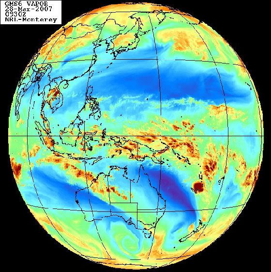
Waar ligt dat systeem momenteel?quote:Op woensdag 28 maart 2007 09:16 schreef Frutsel het volgende:
21P is inmiddels 'geupgrade' naar BECKY
[afbeelding]
Jep, op zo'n beetje dezelfde lokatie als waar van de week die aardbeving was.quote:Op woensdag 28 maart 2007 12:35 schreef highway101 het volgende:
Dat is volgens mij bij Vanuatu en New Caledonia, een eind ten oosten van Australië
Toeval? DE ---> TRU