WKN Weer, Klimaat en Natuurrampen
Lees alles over het onstuimige weer op onze planeet, volg orkanen en tornado's, zie hoe vulkanen uitbarsten en hoe Moeder Aarde beeft bij een aardbeving. Alles over de verwoestende kracht van onze planeet en tal van andere natuurverschijnselen.


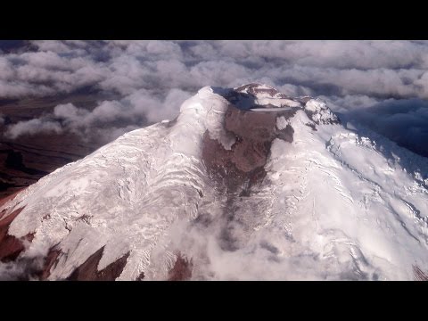
Nu is Bárðarbunga weer aan de beurt.

De waarheid in iemands hoofd is vaak onbuigzamer dan het sterkste staal.

Situatie is stabiel, vandaag geen nieuwe bevingen, wel wordt het gasniveau van de rivier Múlakvísl (oostelijk van Myrdalsjokull) continue gemeten.
Hierbij zijn een verhoogde elektrische geleiding en hoge niveaus van zwaveldioxide en zwavelwaterstof vastgesteld.
Het is het raadzaam om niet in de buurt van de rivier te komen, omdat deze gassen giftig zijn.
De aardbevingen op het schiereiland Reykjanes en bij de Bardarbunga worden vooralsnog niet in verband gebracht met de bevingen bij de Katla.
Katla barstte voor het laatst uit in 1918, waarbij immense stukken gletsjer bij de kust terecht kwamen. De kustlijn werd tijdens de eruptie 5 Km naar het zuiden verplaatst.
http://www.ijsland-enzo.n(...)spagina.asp?tabsel=0
twitter:banndit78 twitterde op woensdag 31-08-2016 om 09:57:40 #Katla Perhaps more significant than recent quakes, rivers to the south showing increase in levels of sulphur dioxide, hydogen sulfide reageer retweet

zou kunnen dat dit de jaarlijkse ontlading van de gletsjermeren is, uiteraard dus vermengd met vulkanische activiteit.quote:Op woensdag 31 augustus 2016 10:06 schreef Frutsel het volgende:
twitter:banndit78 twitterde op woensdag 31-08-2016 om 09:57:40 #Katla Perhaps more significant than recent quakes, rivers to the south showing increase in levels of sulphur dioxide, hydogen sulfide reageer retweet
Hoeft nog niet een bewijs te zijn voor een eruptie, thermisch is het namelijk toch wel daar.
Maar wie weet
Ik zeg: uitbarsting in oktober (Katla of Hekla, of beide als de een de ander triggert... zijn ze onderdeel van hetzelfde systeem?)
Katla en Hekla staan volgens mijn niet in verbinding met elkaar. De Katla en Laki wel.quote:
[..]
zou kunnen dat dit de jaarlijkse ontlading van de gletsjermeren is, uiteraard dus vermengd met vulkanische activiteit.
Hoeft nog niet een bewijs te zijn voor een eruptie, thermisch is het namelijk toch wel daar.
Maar wie weet
Ik zeg: uitbarsting in oktober (Katla of Hekla, of beide als de een de ander triggert... zijn ze onderdeel van hetzelfde systeem?)
Laki is Grimsvotn fissure system. Eldgja is verbonden met Katla. Veiovotn is verbonden met de Bardarbunga. Het is wel mogelijk dat het fissure systeem van die vulkanen onderling verbonden is, maar dat is speculatie. Maar Laki wordt algemeen toegeschreven aan de Grimsvotn. De Eldgja dan weer aan de Katla. En die uitbarsting vond plaats tussen 934 en 940, maar liefst zes jaar aan een stuk maar met een minder hevige intensiteit als die van Laki.
PVDA-PTB lid. Sanders supporter. Student psychologie. Interesse voor films, sport, geschiedenis, multimedia, wereldpolitiek, geologie en het weer.
quote:Misleading information on Katla
The Iceland Met Office has issued a statement to counteract what they feel are misleading reports on volcanic activity in Katla. Numerous tourists have called the office to ask whether it's safe to fly to Iceland. Many have also called to find out whether their families are safe in Iceland.
As an example, the Crawley News wrote today that a Katla eruption could disrupt flights to and from Gatwick, London citing the effect that the Eyjafjallajökull eruption had in 2010.
The Iceland Met Office has therefore seen reason to issue a summary about the recent increase in earthquake activity in Katla.
"We are aware of inaccurate news in recent days about seismic unrest at Katla volcano, Iceland. To avoid any confusion, we would like to reiterate the current status of Katla."
"Media interest in Iceland's volcanoes has remained high since the Eyjafjallajökull eruption of 2010, hence the summary is intended as an official monitoring statement, in case of diverging media reports."
"Since mid-June, earthquake activity within the caldera of the ice-covered Katla volcano has increased above background levels. More than 100 shallow-seated earthquakes have been detected in Katla caldera since 1 June 2016, which is almost four times the monthly average compared to previous years. Earthquakes occurred mainly in bursts ranging from minutes to hours, often with 20 events or more. The two largest earthquakes since the unrest began occurred on 26 July at 03:42 and 03:50 UTC, respectively, both with a magnitude of Mw3.2.
Such summertime increases in seismicity are common at Katla and the ongoing activity within the caldera is similar to summertime unrest observed in 2012 and 2014. Often this increased seismicity occurred in association with drainage of meltwater from several known ice-cauldrons, formed due to hydrothermal activity, as observed almost annually. Since late June 2016 there have been three small floods in Múlakvísl river, an outlet from Mýrdalsjökull, in addition to a flood from the Entujökull glacier. Presently, water-level and electrical conductivity measurements at the bridge over Múlakvísl show increased drainage of geothermal meltwater from Mýrdalsjökull - the ice-cap overlying Katla. We have received several reports throughout the summer of a hydrogen sulphide stench from glacial rivers around Myrdalsjökull.
Around Katla we are not detecting signs of increased ground deformation or bursts of seismic tremor, which are both signals that might indicate movement of magma. We continue to monitor Katla closely and will issue updates on IMO‘s web-site if the situation intensifies. Our assessment is that the volcano is in a period of summertime unrest and it does not show signs of impending eruption, although we cannot rule-out a sudden escalation in seismicity in connection with a hazardous flood."
Het gaat momenteel flink tekeer in de buurt van Reykjavik.
Veel aardbevingen daar.
http://www.ijsland-enzo.nl/ijsland/actueel_beving.asp
Veel aardbevingen daar.
http://www.ijsland-enzo.nl/ijsland/actueel_beving.asp
quote:Katla teases us once again
Tremors were recorded just south of the volcano Katla yesterday, but it remains decidedly unclear if an eruption is imminent.
Vísir reports that the tremor measured 3.9 on the Richter scale, making it not an insignificant quake, but also not a definitive sign that Katla will erupt.
“There have been some unusually large tremors, and quite a few of them have been over 3 [on the Richter scale],” geologist Magnús Tumi Guðmundsson told reporters. “What that means is another story. They are rather shallow tremors, and you would look for more signs of activity, such as expansion and increasing geological heat. If we saw all these things together, than that would be an obvious sign that the volcano is heating up.”
As reported, Katla has been “overdue” for an eruption for some time now. “On average the time between eruptions is 50 years but now the volcano hasn‘t erupted in 98 years,” earthquake hazards coordinator at the Icelandic Met Office Kristín Jónsdóttir told RÚV. “There will be an eruption, it‘s only a question of when.”
However, the current seismic activity around Katla does not indicate an eruption is imminent, professor of geology Páll Einarsson told RÚV.
“Katla is a powerful volcano and we should never forget that,” he said. “However, there is nothing in this recent series of events that indicates especially that volcanic activity or an eruption is imminent. People ask, when will Katla erupt? My response is it erupted in 2011. We just didn’t notice it.”
Here, Páll refers to the glacial flooding which came from four ice cauldrons in the southeastern part of the Katla volcano that year, resulting in no loss of life but the destruction of a bridge over Múlakvísl.
As such, while technically speaking it is only a matter of time before Katla erupts, the latest recorded activity in the region does not indicate an eruption is imminent at this time. The Grapevine will keep readers updated on any new developments as they arise.

Vandaag al 71 bevingen...
quote:Opnieuw heeft er een golf van kleine aardbevingen plaatsgevonden bij de Katla vulkaan.
Gisteren rond de 50 stuks met als zwaarste een beving van 3.0 en vanmorgen alweer 70 stuks, waarvan 7 groter dan 3.5.
De geleidbaarheid van het rivierwater in de buurt is hoger dan gebruikelijk in deze tijd van het jaar, maar niets duidt op een eventuele op handen zijnde uitbarsting.
In het nabije verleden zijn er vaker dit soort verschijnselen geweest.
http://www.ijsland-enzo.n(...)spagina.asp?tabsel=0
Nieuwe swarm. Echter niet al te veel ergs volgens bepaalde vulkaan-amateurs (en wellicht ook wetenschappers, anders was er wel al actie ondernomen).
Ik citeer:
"1. There is currently no signs of an eruption being imminent.
2. The tremor visible since the 27th is due to an ongoing jökulhlaup.
3. The current earthquake swarm is normal for the season, it occurs at a normal spot, and at a normal depth and they are so far of normal size. Nor is this swarm unusually large.
4. The earthquakes are caused by loss of weight. The weight loss is caused by 1 meter of ice having melted away due to the unusually warm summer. There has also been a series of minor Jökulhlaups from Katla in the last two months. This means that the average loss of ice this year is between 2 and 5 meters for the entire Caldera. The loss of ice is uniform all over the caldera.
5. This swarm contains no earthquakes deeper than 1km with the bulk of them being at 0.1km depth. This is consistent with glacial rebound earthquakes and inconsistent with a volcano closing in on an eruption.
6. All earthquakes in the swarm are of tectonic type with no fluid component.
7. An eruption would look like a very large nuclear bomb going off. Unless you see that it is a cloud, the sun, sheep, a car, a farmer, a helicopter, or a flying sheep. To cut it short, unless you are screaming “Holy Crap” it is not an eruption.
What would we expect IF Katla would erupt in the near future.
An intense earthquake swarm with about 100 earthquakes an hour with depths ranging from 0 to 10km depth with magnitudes up to, but not limited to, M5. There would also be different earthquake signatures indicating movement of magma and harmonic tremor as magma moves up the conduits. We are basically talking about activity that is 100 to 100 000 times more intense than we are seeing now."
PVDA-PTB lid. Sanders supporter. Student psychologie. Interesse voor films, sport, geschiedenis, multimedia, wereldpolitiek, geologie en het weer.

IMO (Icelandic Met Office)
"An intense seismic swarm is ongoing since yesterday morning 29 September at Katla volcano. An intense pulse started today at 12:02 (30 September) with several earthquakes around magnitude 3 or larger. No seismic tremor has been detected. Due to the unusually high level of unrest at the Katla volcano we rise the aviation colour code from green to yellow. The volcano continues to be monitored closely."
Burgerlijke Wacht van IJsland:
The National Commissioner of Police and the District Commissioner of Police in South Iceland have declared a Civil Protection Uncertainty phase due to seismic unrest in Katla volcano in Mýrdalsjökull. The contingency plan for an eruption in Mýrdalsjökull has been activated accordingly. Uncertainty phase means that a course of events has started that may lead to natural hazard in the near future. Monitoring, assessment, research and evaluation of the situation is increased.
Increased seismic activity started on September 29 and is still ongoing. Following a meeting with the Scientific Advisory Board of the Icelandic Civil Protection it is likely that the seismic activity is caused by magma movement within the Katla caldera. Three most likely scenarios have been defined.
1 Seismic activity dies out with no further consequences
2. Glacial outburst flood, jökulhlaup, will emerge from the glacier due to a small eruption or emptying of cauldrons
3. Eruption starts in Katla Myrdalsjökull that will force its way through the ice with glacial outburst floods and ash fall
Accordingly a warning has been issued for travellers in the vicinity of Mýrdalsjökull especially around glacial rivers.
______
Toch serieuzer dan ik dacht. De informatie die ik voorhande had, is al verouderd.
[ Bericht 3% gewijzigd door TheRussianBear op 01-10-2016 06:31:28 ]
PVDA-PTB lid. Sanders supporter. Student psychologie. Interesse voor films, sport, geschiedenis, multimedia, wereldpolitiek, geologie en het weer.
Activiteit terug op stabiel niveau zo te zien. Alleen is de vraag nu: voor hoelang?
PVDA-PTB lid. Sanders supporter. Student psychologie. Interesse voor films, sport, geschiedenis, multimedia, wereldpolitiek, geologie en het weer.
maar vergeleken met gisteren en eergisteren is dat erg weinig.
PVDA-PTB lid. Sanders supporter. Student psychologie. Interesse voor films, sport, geschiedenis, multimedia, wereldpolitiek, geologie en het weer.
scheelt nogal idd.quote:
maar vergeleken met gisteren en eergisteren is dat erg weinig.
Twee dagen rond de 70...Ben benieuwd wat er gaat komen.
De aardbevingsgolf bij de Katla-vulkaan neemt weer af. De rust keert terug.
Gisteren nog bijna 40, en vandaag tot nu toe nog maar één.....
Op naar de volgende .....
Er wordt wel nieuwe meetapparatuur rondom de vulkaan geplaatst om te kijken of de vulkaanbodem rijst of daalt.
http://www.ijsland-enzo.n(...)spagina.asp?tabsel=0
Gisteren nog bijna 40, en vandaag tot nu toe nog maar één.....
Op naar de volgende .....
Er wordt wel nieuwe meetapparatuur rondom de vulkaan geplaatst om te kijken of de vulkaanbodem rijst of daalt.
http://www.ijsland-enzo.n(...)spagina.asp?tabsel=0
Currently everything is quiet in Katla volcano. Only two earthquakes happened during the night, the larger one had the magnitude of 2,0 the smaller earthquake had the magnitude of 0,5. There is a good chance that smaller earthquakes have been taking place without being detected due to a bad weather in the area at the moment. Conductivity remains high in Múlakvísl around 180 µS/cm, it is lower today then yesterday, possibly due to heavy rain in south Iceland.
Quiet period in Katla volcano can last up to a week (in my experience). What exactly happens next is impossible to know, but it is clear that Katla volcano is getting real close to erupting. When that might happen is impossible to know as before. All that can be done is to wait and see.
http://www.jonfr.com/volcano/?p=6430
[ Bericht 7% gewijzigd door #ANONIEM op 02-10-2016 20:44:47 ]
Mooi verhaaltje over de sneeuw op het holuhraun gebied. (beter gezegd - gemis van sneeuw)
http://earthobservatory.nasa.gov/IOTD/view.php?id=89076
http://earthobservatory.nasa.gov/IOTD/view.php?id=89076
<a href="http://goo.gl/q8fhTe" target="_blank">FAQ?</a>
<a href="http://goo.gl/gYvZFq" target="_blank">Geel is een zonnige en vrolijke kleur, als hij tenminste enigszins warm is gekleurd en wat naar het oranje neigt</a>
<a href="http://goo.gl/gYvZFq" target="_blank">Geel is een zonnige en vrolijke kleur, als hij tenminste enigszins warm is gekleurd en wat naar het oranje neigt</a>
Misschien in 2020 een grote uitbarsting bij Napels.
http://www.volkskrant.nl/(...)0-ontwaken~a4437473/
http://www.volkskrant.nl/(...)0-ontwaken~a4437473/
nooit geweten dat Napels in IJsland lagquote:
Misschien in 2020 een grote uitbarsting bij Napels.
http://www.volkskrant.nl/(...)0-ontwaken~a4437473/
(╯°□°)╯︵ ┻━┻ ლ(ಠ益ಠლ) ٩͡๏̯͡๏۶ ಠ_ಠ ᕕ( ᐛ )ᕗ

Er is een topic over de Campi Flegrei...quote:
Misschien in 2020 een grote uitbarsting bij Napels.
http://www.volkskrant.nl/(...)0-ontwaken~a4437473/
WKN / Vesuvius heeft grote broer: Supervulkaan kan leven in Europa bedreigen
(heb het ff daarin gegooid
en anders kan dat ook hierin:
WKN / [Vulkanen] The ring of fire #7: Gaia's hete inborst
maar tis ook best een eigen topic waardig
alleen hier gaat het over de vulkanen in IJsland
[ Bericht 4% gewijzigd door Frutsel op 21-12-2016 08:55:58 ]
Sorry ik dacht even dat dit het centrale vulkanen topic was.quote:
[..]
nooit geweten dat Napels in IJsland lag
zo'n vermoeden had ik alquote:
[..]
Sorry ik dacht even dat dit het centrale vulkanen topic was.
(╯°□°)╯︵ ┻━┻ ლ(ಠ益ಠლ) ٩͡๏̯͡๏۶ ಠ_ಠ ᕕ( ᐛ )ᕗ
Ik ben nu in IJsland op familiebezoek voor twee weken.
Misschien dat we nog gaan kijken bij een vulkaan in de buurt als we tijd hebben.
Misschien dat we nog gaan kijken bij een vulkaan in de buurt als we tijd hebben.
"One cries because one is sad. For example, I cry because others are stupid, and that makes me sad."
Gaafquote:
Ik ben nu in IJsland op familiebezoek voor twee weken.
Misschien dat we nog gaan kijken bij een vulkaan in de buurt als we tijd hebben.
Welke vulkaan gaat het worden?
quote:Earthquake in Iceland's Katla volcano
An earthquake of magnitude 3,5 took place in the Katla volcano in South Iceland at 7:09 this morning. The earthquake originated in the west side of the volcano’s caldera, underneath the Mýrdalsjökull glacier. Katla is one of Iceland’s largest and active volcanoes with over twenty eruptions documented since the year 930.
From June to September of last year, the volcano was hit with a series of seismic tremors and high level of unrest. For a few days at the end of September and early October, Katla was raised to “yellow alert” by the Icelandic Met Office, roads near the volcano were closed due to eruption warning, and the volcano was under 24 hour watch by the Met Office.
On September 30th over 200 earthquakes were detected in Katla over a period of 24 hours, the greatest frequency of earthquakes in the volcano since 2011.
quote:Strong 4.2 quake in Katla caldera
Icelandic Met Office has detected a strong and shallow M4.2 earthquake in the center of Katla caldera on January 26, 2017. The quake was followed by M3.0 and a series of smaller earthquakes. In total, 28 earthquakes were registered under Katla since late Wednesday, January 25.
The quakes follow a wave of increased activity in the past couple of weeks. On Monday and Tuesday, January 23 and 24, the volcano registered several large earthquakes, following a wave of activity at the beginning of January, IcelandMag reported.
On Monday, January 23, IMO registered two M3+ earthquakes (M3.0 and M3.3) in the eastern part of the caldera, followed by a large swarm of smaller quakes. This activity was followed by a M3.1 earthquake on January 24.
According to the IMO, the volcano is under close supervision and there are no signs of increased volcanic activity.
On September 29, 2016, an intense seismic swarm started under the volcano and intensified on September 30 with several M3+ earthquakes. The Aviation Color Code was raised to Yellow, the second highest level on a four-color scale. On October 3, IMO stated that the seismic swarm was the largest one in decades, though it appeared to be over.
20 eruptions have been documented at Katla between 930 and 1918, at intervals of 13 to 95 years. Since the last eruption took place in 1918, Katla is long overdue for an eruption.
This volcano is known for strong eruptions, with Volcanic Explosivity Index mostly between 4 and 6 (on a scale of 0 to 8).
Its eruption could pose a threat to civilians due to glacial flooding and significant ash generation.
http://www.iflscience.com(...)anoes-priming-erupt/
quote:Four Of Iceland's Volcanoes Are Priming To Erupt
As we all know, Iceland is a profoundly volcanic place with a variety of eruption styles – from spewing out a little or a lot of lava, to exploding so violently that Europe gets blanketed in ash.
Well, as reported by the Iceland Monitor, the nation’s soothsaying geophysicist Páll Einarsson claims that four of the country’s angry mountains are exhibiting pre-eruptive conditions. Apart from that, however, little information has been given.
The volcanoes in question are Katla, Hekla, Bárðarbunga, and Grímsvötn. With no data or references given in the post, we decided to do a little digging ourselves.
So what of Katla? Well, it’s a rather sizable volcano that has indeed been showing signs of restlessness recently, with tremors hitting around the 4.6M mark. These quakes are possibly indications of magma ascending upwards through the crust and causing it to violently fracture, but as of yet, there’s no definitive proof of this.
Katla occasionally lets off some steam through minor lava flows, but there hasn’t been a major eruption for several decades. Its average recurrence rate for something significant and potentially dangerous is once every 50 years. The last notable event back in 2011 produced some impressive streams of lava, but it was not enough to smash through the Mýrdalsjökull glacier capping it at the surface.
When it inevitably does, a massive ash plume – akin to the one produced by the Eyjafjallajökull in 2010 – will be generated, and North Europe’s airspace will be immediately shut down. According to a recent study, however, such an epic plume only appears once every 44 years, so we’ve probably got some time before that happens again.
It’s worth noting, however, that the 2011 event produced a “jökulhlaup”, a flash flood caused by part of the glacier melting. It was powerful enough to sweep away a major bridge – although luckily without any accompanying deaths.


Dat was blijkbaar toch in de Bardarbunga vulkaan.quote:
https://twitter.com/jonfr500/status/830717606621483010
Meerdere bevingenen +2 waarvan de hoogste 3.6
[ Bericht 0% gewijzigd door #ANONIEM op 12-02-2017 17:15:22 ]
quote:Earthquake swarm under Bardarbunga volcano, Iceland
An earthquake swarm started under Bardarbunga volcano, Iceland during the early morning hours of Wednesday, March 1, 2017. The swarm started at 08:57 with M4.1 (the strongest) and ended at 10:24 UTC. There were no additional earthquakes registered over the next 24 hours.
Bryndís Ýr Gísladóttir, a specialist in natural hazards with the Icelandic Met Office told media that five powerful earthquakes were detected in the caldera of Bardarbunga volcano on March 1, 2017.
The sequence started with M4.1 at 08:57 UTC at a very shallow depth of 0.1 km (0.06 miles) and continued with M2.3 at a depth of 2.3 km (1.5 miles) within the first minute. In total, there were 5 earthquakes with magnitude above 3.0.
Bryndís insists that there are currently no signs of magma unrest in the area and that earthquakes have been common since the volcanic eruption in Bárðabunga ended in 2015. A similar incident happened in January 2017.
Geological summary
The large central volcano of Bárðarbunga lies beneath the NW part of the Vatnajökull icecap, NW of Grímsvötn volcano, and contains a subglacial 700-m-deep caldera. Related fissure systems include the Veidivötn and Trollagigar fissures, which extend about 100 km SW to near Torfajökull volcano and 50 km NE to near Askja volcano, respectively.
Voluminous fissure eruptions, including one at Thjorsarhraun, which produced the largest known Holocene lava flow on Earth with a volume of more than 21 cu km, have occurred throughout the Holocene into historical time from the Veidivötn fissure system.
The last major eruption of Veidivötn, in 1477, also produced a large tephra deposit. The subglacial Loki-Fögrufjöll volcanic system to the SW is also part of the Bárðarbunga volcanic system and contains two subglacial ridges extending from the largely subglacial Hamarinn central volcano; the Loki ridge trends to the NE and the Fögrufjöll ridge to the SW. Jökulhlaups (glacier-outburst floods) from eruptions at Bárðarbunga potentially affect drainages in all directions

quote:Strong earthquake swarm in Bárðarbunga
During the night of 08-March-2017 a strong earthquake swarm took place in Bárðarbunga volcano. Largest earthquake in this swarm had the magnitude of 4,1 and the second largest earthquake swarm had the magnitude of 3,9. Other earthquakes in this swarm where smaller in magnitude.
Earthquake activity happens in Bárðarbunga volcano mainly due to magma being injected into the main volcano at depth. This goes into magma chambers somewhere in the volcano, current data suggests that the magma chamber that erupted in in August 2014 to February 2015 is currently inflating. The rate of this type of earthquake activity has gone down in Bárðarbunga volcano, this used to be a weekly activity but now only happens every 2 to 4 weeks at the moment. This slowdown in activity is likely to continue if nothing else happens (new eruption or dyke activity).
quote:Bárðarbunga volcano joins Hekla: 3.2 magnitude quake and earthquake swarm over weekend
The 4.5 magnitude earthquake west of volcano Hekla on Saturday was followed up by a 3.2 magnitude quake in the Bárðarbunga caldera later the same evening. The quake, which had its epicenter at a depth of 4.3 km (2.7 miles) in the N.E. part of the caldera was followed by a swarm of smaller quakes, including two 2.1 and 2.5 magnitude quakes, in the N.E. and S.E parts of the caldera.
What is going on?
It is unlikely the two episodes are connected. The earthquakes in Bárðarbunga are caused by magma thrusting its way from the mantle to the magma chambers of the volcano, refilling it after the 2014-15 Holuhraun eruption. Bárðarbunga is preparing for continued volcanic activity.
Volcanic zones and seismic rift zones
The Saturday quake west of Hekla took place in the South Iceland Seismic Zone, a transform fault between offset sections of the Mid-Atlantic Ridge which runs through Iceland. The zone is made up of a series of fracture faults which run from SW to NE. The zone extends from the volcano Hengill, the easternmost part of the Reykjanes volcanic zone to Hekla, which is the westernmost volcano in the East Volcanic Zone.
The massive "South Iceland Quake"
There are no active volcanoes in the South Iceland Seismic Zone, but it is extremely active. The area sits between the two volcanic zones, and is constantly being pulled in two different directions, causing tension to build up in the crust which is then periodically released in earthquakes.
The zone has been the source of the most powerful earthquakes in Iceland, as the most powerful earthquake which has taken place in Iceland since the country was settled took place in the Southern Seismic Zone.
Read more: All of Iceland‘s major volcanoes showing unusually high levels of activity
On 1784 a massive earthquake, which is believed to have been 7.1 magnitude, shook all of southern Iceland, causing widespread damage to farmhouses.
The second largest earthquake, and the largest to be measured with modern equipment, was detected in 1912. This quake was 7.0 on the Richter scale. Both quakes took place close to Saturday's tremor. Quakes of this magnitude are believed to hit once every 100-150 years, and could cause significant damage. Locals in South Iceland are still waiting for the "big one".
quote:Earthquakes and tremors continue around notorious volcano Katla
The past few days have seen a swarm of tremors around Katla volcano, but yesterday they reached over a 3 in magnitude or up to 3.6. According to reports quakes aren’t always signs of looming eruptions although the seismic activity has been frequent of late. The Icelandic Met Office is closely monitoring the volcano and surrounding area.
Katla is a large subglacial volcano in southern Iceland. It’s been dormant under the Mydalsjokull glacier for almost 100 years, but it’s considered a very active volcano with twenty documented eruptions between 930 and 1918, with intervals of 13–95 years.
Katla hasn’t erupted forcefully since 1918, although there may have been small eruptions under the icecap that didn’t break the ice, including ones in 1955, 1999, and 2011. Prior eruptions have measured with a Volcanic Explosively Index of between VEI-4 and VEI-6 on a scale of 0 to 8. In comparison, the infamous 2010 Eyjafjallajokull eruption had a VEI-4. The last major eruption started on 12 October 1918 and lasted for 24 days. It was likely a VEI-5 level eruption.
Katla’s present dormancy is among the longest in known history and many theorize that the current seismic activity is a sure sign of a pending eruption although the Icelandic Met Office assures that there are no definite tell tale signs of a looming eruption.
Volcanologist Jon Friman speculates that the depth of some of the quakes indicates that fresh magma is making its way upward in the magma chamber. One of the quakes was measure on 14.4 km depth and Friman takes that as an indicator of the mountain getting ready to erupt, quakes on such a depth are caused by magma movement rather than movement in the earth’s crust. The greatest depth measured in this series of quakes is 15.5 km and the one closest to the surface was 0.1 km down.
The string of tremors can be observed online with updates of 60 seconds in 3D images in a program developed and made by Baering Gunnar Steinthorsson. The images display the size and depth of the quakes almost in real time. The colour coding for the age of the quakes is the same as the Icelandic Met Office uses, the newest are red, then orange, yellow, blue and the oldest ones are dark blue. The display is based on data from the Met office and it only displayed data which has been overviewed by a Volcanologist.
The 1918 eruption in Katla was major, lasting almost a month and resulting in extending the southern coast by 5 km due to lava flow deposits.


Hmm interessant. Bekende van mij zit momenteel in IJsland. Als het al vrij snel op handen is dan kan zij er wel eens problemen mee krijgen.
En wij gaan het in West Europa ook wel merken. Gelukkig vrij laat want anders zat ik straks ook met mijn vlucht die in ergste (of beste eigenlijk want wil niet weg) geval niet kan.
En wij gaan het in West Europa ook wel merken. Gelukkig vrij laat want anders zat ik straks ook met mijn vlucht die in ergste (of beste eigenlijk want wil niet weg) geval niet kan.
Code geel voor de Katla
YELLOW: Volcano is experiencing signs of elevated unrest above known background levels.
or, after a change from higher alert level:
Volcanic activity has decreased significantly but continues to be closely monitored for possible renewed increase.
YELLOW: Volcano is experiencing signs of elevated unrest above known background levels.
or, after a change from higher alert level:
Volcanic activity has decreased significantly but continues to be closely monitored for possible renewed increase.

en? standaard aantal uur aan waarschuwing is nu wel voorbij: is hij uitgebarsten? 
(╯°□°)╯︵ ┻━┻ ლ(ಠ益ಠლ) ٩͡๏̯͡๏۶ ಠ_ಠ ᕕ( ᐛ )ᕗ
quote:Series of quakes near active volcano
A number of earthquakes were detected at Bárðarbunga in Vatnajökull tonight, according to the Icelandic Met Office. The largest quake was 4.1 in magnitude, with another one following at 4.0.
The quakes were a total of 21, with three of them over 3.0 in magnitude. There are currently no signs of increased volcanic activity in the area, although it has seen a large number of quakes over the past years.
Bárðarbunga is located north-west of Vatnajökull, Iceland's largest glacier. It is considered a highly active volcanic area, having last erupted between the years 2014-2015.