WKN Weer, Klimaat en Natuurrampen
Lees alles over het onstuimige weer op onze planeet, volg orkanen en tornado's, zie hoe vulkanen uitbarsten en hoe Moeder Aarde beeft bij een aardbeving. Alles over de verwoestende kracht van onze planeet en tal van andere natuurverschijnselen.


El Golfo, El Hierro, De plek waar de meeste aardbevingen zijn geregistreerd
quote:Recordaantal aardbevingen op Canarisch eiland
Nog nooit eerder werden er zoveel aardbevingen achter elkaar geregistreerd op het kleine vulkanische eilandje El Hierro, het kleinste van de Canarische Eilanden. De reeks van maar liefst 720 bevinkjes heeft de overheid van deze eilandengroep voor de kust van West Afrika ertoe doen besluiten om voor het eerst in de geschiedenis een vergadering bijeen te roepen van het Stuurcomité van Vulkanische Monitoring. Dit comité werd opgericht om specifieke plannen te realiseren, die de burgerbevolking dienen te beschermen en noodplannen voor vulkanische risico’s moeten ontwikkelen. Inmiddels wordt gesproken over een ‘significante dreiging van seismische activiteit’.
Het Nationaal Geografisch Instituut (IGN) en het Volcanologische Instituut van de Canarische eilanden blijft nauwlettend de aardbevingen in de gaten houden, waarvan de kracht van de bevingen (elke dag!) ligt tussen de 1 en 3 op de Richterschaal. De meerderheid van de bevingen vindt plaats tussen 5 en 15 km diepte.
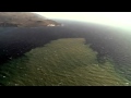
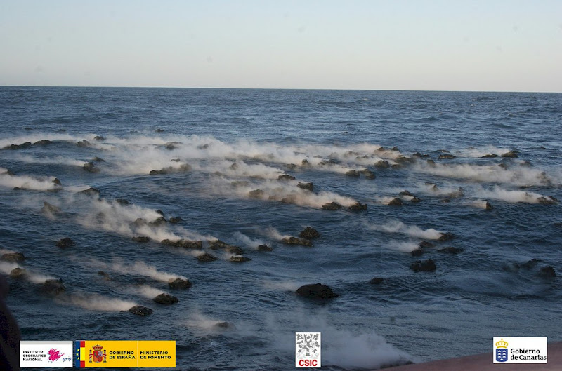
Volgens de autoriteiten betekent deze seismische activiteit nog niet direct dat een grotere, significante aardbeving zal plaatsvinden. Het merendeel van de bevingen die zijn geregistreerd, vonden plaats in het Noord Westen van het 280 vierkante kilometer kleine eilandje, bij het plaatsje El Golfo (zie foto hieronder). Een aardbeving op deze plaats zorgde er zo’n 50.000 jaar geleden voor, dat er een enorme landverschuiving plaatsvond, waarbij de helft van de vulkaan in zee gleed. Hierdoor ontstond een ca. 100 meter hoge tsunami die naar de overzijde van de Atlantische oceaan zou zijn gegleden. Schuin tegenover dit eilandje, in het verlengde van de resterende halve kratermond, ligt het Noord Amerikaanse continent..
quote:El Hierro Earthquake Swarm Enters Third Week
The intensity of earthquakes recorded on the smallest of the Canary Islands, El Hierro, has increased slightly during the last 24 hours. However, the total number of earthquakes recorded daily has lessened since the earthquake swarm initially began on 17 July.
The total number of tremors recorded during the past two weeks has now exceeded 1,050, according to the Instituto Geografico Nacional (IGN).
The majority of the earth tremors ranged between 1-2 magnitude, but during the past 24 hours there have been least five tremors measuring in excess of 2.0 magnitude on the Richter Scale. A 2.4 magnitude earthquake was recorded at 4:56 p.m. local time on Sunday (31 July 2011).
Approximately 50 earth tremors were recorded on Sunday, according to local earthquake monitoring agency Actualidad Volcánica de Canarias (AVCAN). The number is slightly down on the number of tremors recorded on Saturday and significantly less than the 195 earthquakes recorded on 22 July.
quote:The vast majority of the tremors have been recorded in the northwest of the 278.5-square-kilometre island at El Golfo, the location of a massive landslide that created a 100-metre high tsunami almost 50,000 years ago.
The earthquake swarm, prompted the Canary Islands Government to convene the first ever meeting on 22 July of the Steering Committee and Volcanic Monitoring, reflected in the Specific Plan Protection Civil and Emergency for Volcanic Risk, given what it described “the significant increase in seismic activity”. The Committee met again on Friday 29 July to discuss the low magnitude seismic activity. It reported that it had stepped up its seismic monitoring operations to identify the source of the earthquakes.
Following an evaluation of seismic and volcanological information gathered by the IGN and volcanological Institute of the Canary Islands, the Committee agreed to activate “monitoring and surveillance mechanisms necessary to coordinate the actions of civilian self-protection and information to people listed in the Plan” (translated from Spanish press release). It remains unclear, however, if the unprecedented seismic activitiy on El Hierro is a precursor to a possible future increase in earthquake or volcanic activity.
Earthquake swarms are events where a local area experiences sequences of many earthquakes striking in a relatively short period of time. The length of time used to define the swarm itself varies, but the United States Geological Survey (USGS) points out that an event may last for days, weeks, or months.
El Hierro’s Volcanic/Seismic Past
El Hierro is situated in the most southwestern extreme of the Canaries. The island was formed after three successive eruptions, and consequent accumulations, the island emerged from the ocean as an imposing triangular pyramid crowned by a volcano more than 2,000 metres high.
The volcanic activity, principally at the convergence of the three ridges, resulted in the continual expansion of the island. A mere 50,000 years ago, as a result of seismic tremors which produced massive landslides, a giant piece of the island cracked off, crashed down into the ocean and scattered along the seabed. This landslide of more than 300km3 gave rise to the impressive amphitheatre of the El Golfo valley and at the same time caused a tsunami that most likely rose over 100 metres high and probably reached as far as the American coast.


Links
Live webcams op het eiland El Hierro
Actuele seismische activiteit
AVCan - vulcanologiesch instituut Canarische eilanden
Spaans geografisch instituut
Canariesnews
Tumbit
en op twitter kun je zoeken op #hierro, #elhierro of #viveelhierro
@noticiacanaria Wel veel ander nieuws
@canariesnews
@eruptionsblog
@teideano 1 van de onderzoekers op El Hierro
Gerelateerde topics
[Vulkanen] The ring of fire #6: Waar diverse vulkanen puffen
Aardbevingen #13
Mega tsunami door in zee vallen van eiland La Palma?
[ Bericht 4% gewijzigd door bwt op 08-12-2011 15:40:43 ]
<a href="http://goo.gl/q8fhTe" target="_blank">FAQ?</a>
<a href="http://goo.gl/gYvZFq" target="_blank">Geel is een zonnige en vrolijke kleur, als hij tenminste enigszins warm is gekleurd en wat naar het oranje neigt</a>
<a href="http://goo.gl/gYvZFq" target="_blank">Geel is een zonnige en vrolijke kleur, als hij tenminste enigszins warm is gekleurd en wat naar het oranje neigt</a>
quote:NOTE AVCAN 343 - EARTHQUAKE ACTIVITY-VOLCANIC - HIERRO ISLAND - 25 November 2011-10:30 h peninsular - seismic-volcanic activity continues with moderate to high seismicity in the Gulf marine area. According to the PEVOLCA have appeared "quite often a type of volcanic signals (LP). Continued significant volcanic tremor signal in the Restinga area, which remains small amplitude oscillations, more unstable and more explosions, possibly hydromagmatic . the magnitude of the earthquakes between 3.1 and 1.5. New quakes 6. earthquakes senses 1. Depths one to 15, and the rest to 20km. the day before yesterday 21. Yesterday 8. Today van 4. A total of 11,807 earthquakes are located in El Hierro by IGN from 9:00 am of July 19, 2011 (Enrique).
<a href="http://goo.gl/q8fhTe" target="_blank">FAQ?</a>
<a href="http://goo.gl/gYvZFq" target="_blank">Geel is een zonnige en vrolijke kleur, als hij tenminste enigszins warm is gekleurd en wat naar het oranje neigt</a>
<a href="http://goo.gl/gYvZFq" target="_blank">Geel is een zonnige en vrolijke kleur, als hij tenminste enigszins warm is gekleurd en wat naar het oranje neigt</a>
quote:The truth is that the photos of non-tip / Guardia Civil of the last day November 23, 2011 are beautiful, and one more thing to show us how small is the nucleus of the Restinga, at the foot of a volcanic cone aligned with other more behind and in line with the town, besides the spot next to the town, the thing is close, too much for my taste, so if the picture is very good, is a cover of National Georgraphic so far indicating eruption in el Hierro (Enrique).
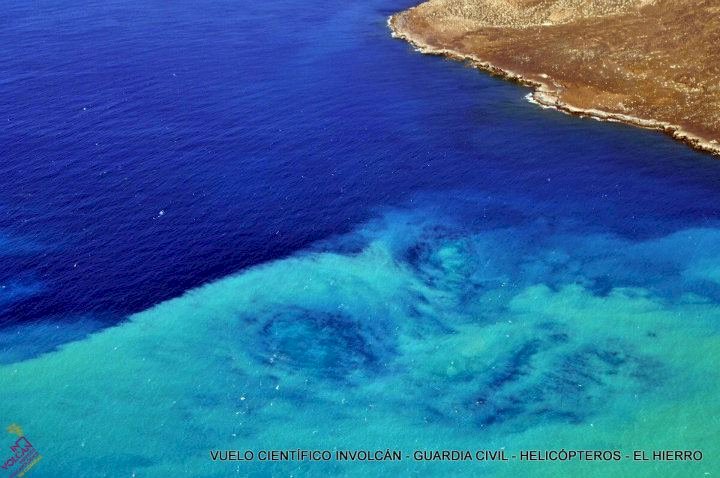
Picture of intense volcanic gas discharge by submarine eruptive activity south of the Restinga on the morning of November 23, 2011. Photo: Civil Guard / InVolCan

quote:Todo se cuadra para la erupción en el norte
The great stain that is leaving the volcano on La Restinga overshadowed on Thursday what is happening in the north of El Hierro, where the location of small tremors in the seismicity and the increase in the rate of CO2 targets shallower magma movements.
The seismicity in the north of El Hierro is decreasing to the point that this Thursday there were only three earthquakes, however, and according to the committee of scientific work to the direction of the Civil Protection Plan for Volcanic Risk (Pevolca) have appeared "quite often a type of volcanic signals (lp) in the Stations of the North Coast." These signals volcanic long period (long period) are equivalent to small tremors associated interrupted movement of magma.
The director of the National Geographic Institute (IGN), María José Blanco, rejected that means full already tremor signal in the north and, therefore, a rash, but admitted that the magma is moving appreciably off the coast . And it does more superficial positions if one looks at it this concatenation of small tremors is linked to a shallower seismicity in recent days in the north, between 15 and 18 kilometers deep.
Furthermore, these two elements adds an increased gas pressure in the magmatic thermal system. The last measurement of the diffuse emission of carbon dioxide (CO2) from the Canary Islands volcanological Institute (Pevolca) on day 20 is around 2,200 tonnes per day (400 tons more than four days before), a value equivalent to 6.34 times the normal average value on the island.
CO2 is the driving force of eruptions, which is why some experts have the feeling that they may be facing an eruptive phase in the north.
quote:Clouds and transit seismic hypocenters of seismicity to 11/24/2011
Clouds of seismic events and daily traffic of seismicity for seismic-volcanic crisis on the island of El Hierro to 24 November. of 2011

[ Bericht 13% gewijzigd door bwt op 25-11-2011 13:53:59 ]
<a href="http://goo.gl/q8fhTe" target="_blank">FAQ?</a>
<a href="http://goo.gl/gYvZFq" target="_blank">Geel is een zonnige en vrolijke kleur, als hij tenminste enigszins warm is gekleurd en wat naar het oranje neigt</a>
<a href="http://goo.gl/gYvZFq" target="_blank">Geel is een zonnige en vrolijke kleur, als hij tenminste enigszins warm is gekleurd en wat naar het oranje neigt</a>
quote:The diffuse emission of carbon dioxide by the insular volcanic system is already six times the normal average
The diffuse flux measurements of carbon dioxide (CO2) since last July by scientists at the Institute of the Canary Islands volcanological (involcan) at El Hierro reflect an upward trend in their emission into the atmosphere by the volcano island, which is about the 2,200 tons per day. This is a value equivalent to 6.34 times the normal average for the island of El Hierro, which is 345 tons per day.
On the other hand, as reported in a statement, the stain caused by the underwater eruption off the coast of La Restinga has remained widespread in surface and appreciated "some sporadic changes in hue." The sending center has presented a brown color associated with the emission of fine material. On the tremor signal, its amplitude has remained constant and low throughout the day, with some slight increases and no evidence of any second source of tremor . Similarly, with respect to deformation, the results of processing the data obtained with the GPS stations do not reflect any clear trend in the horizontal components other than the regional. Vertically majority view stations and only a collapse of the Gulf seem to point to stability, mainly in the east. Also, the National Geographic Institute (IGN) confirmed the direction of the Civil Protection Plan for Volcanic Risk (Pevolca), that during this eight earthquakes were located Thursday, with only one of them felt by the population, with an intensity of II. Most of these events are located in the Gulf, aligned in the northeast-southwest in the sea at a depth between 15 and 24 kilometers. The more intense, with a magnitude of 2.8 on the Richter scale, had place at 20:54 hours west of La Frontera at a depth of 16 kilometers. In total, since the day July 17, 2011 11 832 earthquakes have been located.
<a href="http://goo.gl/q8fhTe" target="_blank">FAQ?</a>
<a href="http://goo.gl/gYvZFq" target="_blank">Geel is een zonnige en vrolijke kleur, als hij tenminste enigszins warm is gekleurd en wat naar het oranje neigt</a>
<a href="http://goo.gl/gYvZFq" target="_blank">Geel is een zonnige en vrolijke kleur, als hij tenminste enigszins warm is gekleurd en wat naar het oranje neigt</a>
quote:The evolution curve of the cumulative seismic energy released looks set moderating its rise, releasing less and less energy.
This may be because the system is relaxing or on the contrary it has been re-hitches and a few days ago, since it is still early to rely, as the last time you did this, ended with a 4.6, Will this in the coming days? or else I still relax, releasing less and less energy?
We'll see what happens, but seeing the gases and the deformation does not seem to be relaxed, especially gases (Enrique)
[bron]
<a href="http://goo.gl/q8fhTe" target="_blank">FAQ?</a>
<a href="http://goo.gl/gYvZFq" target="_blank">Geel is een zonnige en vrolijke kleur, als hij tenminste enigszins warm is gekleurd en wat naar het oranje neigt</a>
<a href="http://goo.gl/gYvZFq" target="_blank">Geel is een zonnige en vrolijke kleur, als hij tenminste enigszins warm is gekleurd en wat naar het oranje neigt</a>
quote:Update 26/11 – 12:42
The best you can do at the moment is staring at our webcam. For minutes in a row, we have seen periods of smoking magma. The smoking magma was first seen by reader Hans-Werner who also captured the image on his screen. Hans-Werner has told us also that the webcam was operated in the right direction when it happened. This is also great news to hear as the webcam operators seem to have learned from past critics.
Update 26/11 11:30
Joke reports that her friend, the La Restinga human webcam, has growing fear that a new evacuation is not far away as the stain is very visible from the village this morning (Ian reported the same in his 09:52 update). She thinks that if the wind eventually changes, La Restinga might be in the center of the storm again.
Update 26/11 11:28
- The volcanic earthquakes have picked up their daily work again. Since 09:21 this morning 4 M+1.5 earthquakes have been listed by IGN, the strongest one being a M 2.7 earthquake NW of Frontera
Update 26/11 09:52 Ian Carson reports :
A lot of stain right to coast at La Restinga but no emission points can be seen by me. I don't think the earlier mention of a closer one was true. Harmonic calm.
Update 26/11 09:43
- 3 earthquakes have occurred since midnight, all of them less than 1.5, the reason why these quakes are not listed in the IGN main list. 2 of these quakes had a depth of 14.8 km
- while looking at the webcam for a longer period a lot of mysteries are showing up. Here are a few of them :
- why can toppling waves almost only be spotted in the stain waters ?
- why do we have sudden color change in parts of the stain ?
Update 26/11 09:05
- the beautiful calm Las Calmas sea enables us this morning to trace the eruption vent. The arrow on the picture below is the location were we expect that the vent is (probably) degassing. About 15 to 30 minutes ago, we have spotted here the source of a white stain. Unfortunetely the Telefonica operators have since zoomed more to the left . The Telefonica operators have since zoomed the image and probable stirring action has to be located at the upper right corner.


<a href="http://goo.gl/q8fhTe" target="_blank">FAQ?</a>
<a href="http://goo.gl/gYvZFq" target="_blank">Geel is een zonnige en vrolijke kleur, als hij tenminste enigszins warm is gekleurd en wat naar het oranje neigt</a>
<a href="http://goo.gl/gYvZFq" target="_blank">Geel is een zonnige en vrolijke kleur, als hij tenminste enigszins warm is gekleurd en wat naar het oranje neigt</a>
Pluimpje is momenteel weer weg
In this world of evil and darkness I'm looking for the one girl that has the power to bring light into my heart. A light so pure that my evil thoughts about this world and the people living on it will vanish and I'll finally experience true love.
Das vast weer zo'n drijvende lava brok geweest
<a href="http://goo.gl/q8fhTe" target="_blank">FAQ?</a>
<a href="http://goo.gl/gYvZFq" target="_blank">Geel is een zonnige en vrolijke kleur, als hij tenminste enigszins warm is gekleurd en wat naar het oranje neigt</a>
<a href="http://goo.gl/gYvZFq" target="_blank">Geel is een zonnige en vrolijke kleur, als hij tenminste enigszins warm is gekleurd en wat naar het oranje neigt</a>
ook nu nog steeds lava stenen die omhoog komen.
Linkje naar video van die stenenquote:Data Update 26/11 – 23:42
- A lot of action in the sea means mostly a limited number of earthquakes. Today only 8.
- Depth in between 14.8 and 20.3 km
- Medium harmonic tremor with a limited number of bursts
Ian Carson reports from El Hierro :
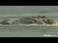
I went to La Restinga at first light to see any overnight developments - there weren't any - just the usual stain a bit closer to the shore. After an hour and as it was lovely morning, I went sightseeing. I was returning to La Restigna when I got the message of smoking lava stones.
When I arrived there were little 'bombs coming to the surface intermittently. These got more frequent for a while and then only one every 5 mins. After a while the activity again increased, bright Jacuzzi and many stones coming up, generally smaller than the first batch. Stones were visible on the surface. The affected area seemed to be getting larger and the activity seemed quite intense when I had to leave at 17.40. I look forward to first light ! The Ian Carson images are included in the group below. Click on the image to watch the entire group of pictures.
<a href="http://goo.gl/q8fhTe" target="_blank">FAQ?</a>
<a href="http://goo.gl/gYvZFq" target="_blank">Geel is een zonnige en vrolijke kleur, als hij tenminste enigszins warm is gekleurd en wat naar het oranje neigt</a>
<a href="http://goo.gl/gYvZFq" target="_blank">Geel is een zonnige en vrolijke kleur, als hij tenminste enigszins warm is gekleurd en wat naar het oranje neigt</a>
Earthquake report meld een beving van vannacht op 1,9 KM diepte. Deze is echter niet terug te vinden op de lijst van IGNquote:Data Update 27/11 – 09:14
The activity at the eruption area gets even stronger than before. The webcam operator just zoomed out a little to have a wider scoop. Earthquake-report.com expects more action today. A stronger Jacuzzi and from time to time a swelling geyser type action.
Data Update 27/11 – 08:50
The coast guard boat on the image will have the best pictures. What he does is however very risky as nobody can predict the start of a subaerial phase of the eruption.
Data Update 27/11 – 08:09
- the action which started yesterday by floating smoking stones is continuing this morning, hot pyroclastic material is floating to the surface. Just behind a weak Jacuzzi is formed. All this can be seen on the Telefonica eruption webcam.


quote:NOTE AVCAN 346 - EARTHQUAKE ACTIVITY-VOLCANIC - HIERRO ISLAND - 26 November 2011-21:30 h peninsular - seismic-volcanic activity continues with moderate to high seismicity in the Gulf marine area. Continue an important sign of volcanic tremor in the Restinga area, which is maintained in amplitude with increasing trend (10%) since the last note, with small oscillations and some explosions, possibly hydromagmatic (by the way the pattern has repeated explosions every 3 hours approx). The magnitude of the earthquakes between 2.2 and 1.5. New earthquakes 4. Depths to 17, 19, 19 and 20km. Before yesterday 8. Yesterday 10. Now go 8. A total of 11,821 earthquakes are located in El Hierro by IGN from 9:00 am of July 19, 2011 (Enrique).
NOTE AVCAN 347 - EARTHQUAKE ACTIVITY-VOLCANIC - HIERRO ISLAND - 27 November 2011-11:15 h peninsular - seismic-volcanic activity continues to moderate, with seismicity in the Gulf marine area. Continue an important sign of volcanic tremor in the Restinga area, which is maintained in amplitude with the low tendency (5-10%) since the last note, with small oscillations, and more unstable, with some explosions, possibly hydromagmatic (indeed the pattern of repeated explosions every 3h approx). The magnitude of the earthquakes between 2.3 and 1.1. New earthquakes 11. 17 and 20km depth (and two at 2 and 14km and three to 21, 22 and 25km). The day before yesterday 10. Yesterday 9. Today are 10. A total of 11,832 earthquakes are located in El Hierro by IGN from 9:00 am of July 19, 2011 (Enrique).
[ Bericht 10% gewijzigd door bwt op 27-11-2011 12:20:10 ]
<a href="http://goo.gl/q8fhTe" target="_blank">FAQ?</a>
<a href="http://goo.gl/gYvZFq" target="_blank">Geel is een zonnige en vrolijke kleur, als hij tenminste enigszins warm is gekleurd en wat naar het oranje neigt</a>
<a href="http://goo.gl/gYvZFq" target="_blank">Geel is een zonnige en vrolijke kleur, als hij tenminste enigszins warm is gekleurd en wat naar het oranje neigt</a>
Video van de activiteit van vandaag.
Kustwacht bootje is nu opnieuw bij de "hotspot"
http://hierroendirecto.movistar.es/
[ Bericht 6% gewijzigd door bwt op 27-11-2011 13:13:43 ]

Kustwacht bootje is nu opnieuw bij de "hotspot"
http://hierroendirecto.movistar.es/
[ Bericht 6% gewijzigd door bwt op 27-11-2011 13:13:43 ]
<a href="http://goo.gl/q8fhTe" target="_blank">FAQ?</a>
<a href="http://goo.gl/gYvZFq" target="_blank">Geel is een zonnige en vrolijke kleur, als hij tenminste enigszins warm is gekleurd en wat naar het oranje neigt</a>
<a href="http://goo.gl/gYvZFq" target="_blank">Geel is een zonnige en vrolijke kleur, als hij tenminste enigszins warm is gekleurd en wat naar het oranje neigt</a>

Er gebeurd van alles zo te zien.
Ben benieuwd naar de foto's die gemaakt worden.
Ben benieuwd naar de foto's die gemaakt worden.
<a href="http://goo.gl/q8fhTe" target="_blank">FAQ?</a>
<a href="http://goo.gl/gYvZFq" target="_blank">Geel is een zonnige en vrolijke kleur, als hij tenminste enigszins warm is gekleurd en wat naar het oranje neigt</a>
<a href="http://goo.gl/gYvZFq" target="_blank">Geel is een zonnige en vrolijke kleur, als hij tenminste enigszins warm is gekleurd en wat naar het oranje neigt</a>
Toen de heli wegvloog zag ik een grote groene vlek tevoorschijn komen.
Jammer dat de heli net weg was - zou moie foto's opgeleverd hebben.
Vanaf een uur of 8 lijken de tremors ook weer meer aanwezig te zijn.
Jammer dat de heli net weg was - zou moie foto's opgeleverd hebben.
Vanaf een uur of 8 lijken de tremors ook weer meer aanwezig te zijn.

<a href="http://goo.gl/q8fhTe" target="_blank">FAQ?</a>
<a href="http://goo.gl/gYvZFq" target="_blank">Geel is een zonnige en vrolijke kleur, als hij tenminste enigszins warm is gekleurd en wat naar het oranje neigt</a>
<a href="http://goo.gl/gYvZFq" target="_blank">Geel is een zonnige en vrolijke kleur, als hij tenminste enigszins warm is gekleurd en wat naar het oranje neigt</a>

En de beelden die bij de foto's horen.
En vandaags tremors

En vandaags tremors

<a href="http://goo.gl/q8fhTe" target="_blank">FAQ?</a>
<a href="http://goo.gl/gYvZFq" target="_blank">Geel is een zonnige en vrolijke kleur, als hij tenminste enigszins warm is gekleurd en wat naar het oranje neigt</a>
<a href="http://goo.gl/gYvZFq" target="_blank">Geel is een zonnige en vrolijke kleur, als hij tenminste enigszins warm is gekleurd en wat naar het oranje neigt</a>
quote:Data Update 28/11 – 10:01 – Ian Carson reports
Just had long chat with scientists. Depth of vent yesterday was imprecise according to the captain. Now the real news, a new scientific ocean survey ship is coming tomorrow to map the area. It will also do work in the north (El Golfo region).
Data Update 28/11 08:33
- Harmonic tremor remained strong all night
- Contrary to yesterday, no smoking stones this morning. We have just watched a time lapsed period since the beginning of daylight and no surface activity has been noticed on the webcam
- Ian Carson reports that the usual stain is visible but no stirring activity
- 3 earthquakes since midnight, the strongest one being a M 2.0
- depths in between 17 and 21 km
- weather outlook for today : beautiful weather today, wind blowing from the east, maximum wave height : 0.6 meter, wind speed : 1 to 2 knots only in other words a perfect day for volcano activity spotting
[ Bericht 39% gewijzigd door bwt op 28-11-2011 12:26:18 ]
<a href="http://goo.gl/q8fhTe" target="_blank">FAQ?</a>
<a href="http://goo.gl/gYvZFq" target="_blank">Geel is een zonnige en vrolijke kleur, als hij tenminste enigszins warm is gekleurd en wat naar het oranje neigt</a>
<a href="http://goo.gl/gYvZFq" target="_blank">Geel is een zonnige en vrolijke kleur, als hij tenminste enigszins warm is gekleurd en wat naar het oranje neigt</a>
net weer eens gekeken naar de hoeveelheid bevingen vandaag.quote:@eruptionsblog
New post! Taking a closer look at the mixing magmas erupting from El Hierro in the Canary Islands - a complicated mess: http://www.wired.com/wire(...)-el-hierro-eruption/
WOW
Vanaf 11 uur is het weer volop raak
11 stuks waarvan 7 het laatste uur.
Zwaarste een 2.9
1115294 28/11/2011 13:32:19 27.7987 -18.0564 20 2.9 4 NW FRONTERA.IHI

[ Bericht 21% gewijzigd door bwt op 28-11-2011 16:00:55 ]
<a href="http://goo.gl/q8fhTe" target="_blank">FAQ?</a>
<a href="http://goo.gl/gYvZFq" target="_blank">Geel is een zonnige en vrolijke kleur, als hij tenminste enigszins warm is gekleurd en wat naar het oranje neigt</a>
<a href="http://goo.gl/gYvZFq" target="_blank">Geel is een zonnige en vrolijke kleur, als hij tenminste enigszins warm is gekleurd en wat naar het oranje neigt</a>
Mooie pagina van IGN met de El Hierro eruption foto's
http://www.01.ign.es/ign/(...)os/GaleriaFotos.html
Dit soort brokken komen naar boven. Het wittige is porreusmet gassen er in. Hier komt bij afkoeling water in en het verdrijft de gassen zodat het weer naar de bodem zinkt. (in verschillende formaten zoals e al hebben kunnen zien.)
http://www.01.ign.es/ign/(...)os/GaleriaFotos.html
Dit soort brokken komen naar boven. Het wittige is porreusmet gassen er in. Hier komt bij afkoeling water in en het verdrijft de gassen zodat het weer naar de bodem zinkt. (in verschillende formaten zoals e al hebben kunnen zien.)

<a href="http://goo.gl/q8fhTe" target="_blank">FAQ?</a>
<a href="http://goo.gl/gYvZFq" target="_blank">Geel is een zonnige en vrolijke kleur, als hij tenminste enigszins warm is gekleurd en wat naar het oranje neigt</a>
<a href="http://goo.gl/gYvZFq" target="_blank">Geel is een zonnige en vrolijke kleur, als hij tenminste enigszins warm is gekleurd en wat naar het oranje neigt</a>
Er lijkt iets te gebeuren veel dichter bij de kust. De kwaliteit is niet goed genoeg om er echt iets van te maken, maar dat de Eruptie-cam er op gericht staat, zegt toch wel iets...
Is het normaal dat dit gedoe zo lang duurt? Andere vulkanen duren, voor mijn gevoel althans, een stuk minder lang (of zijn minder lang in het nieuws?).
Hangt heel erg van de vulkaan af. Je hebt vulkanen die 'binnen een paar dagen' tot leven komen. Er zijn vulkanen die heel snel weer uitdoven. Je hebt vulkanen die er jaren over doen eer er een eruptie volgt. Maar je hebt ook vulkanen die jarenlang onafgebroken uitbarsten. Extreem voorbeeld daarvan is de Kilauea-vulkaan op Hawaii, die onafgebroken lava spuwt sinds 1983 (maar daar hoor je uiteraard niet elke dag wat over)
Ik hoop dat mn oud professor Geologie nog leeft en nu op El Hierro zit... Prachtige verhalen altijd over vulkanen maar zelf nog nooit een uitbarsting meegemaakt ..
En het dagelijkse tremor plaatjequote:NOTE AVCAN 350 - EARTHQUAKE ACTIVITY-VOLCANIC - HIERRO ISLAND - 28 November 2011-22:30 h peninsular - volcanic seismic activity continues to moderate-high, with seismicity in the Gulf marine area. Continue an important sign of volcanic tremor in the Restinga area, with an amplitude that has fallen and risen again (down to 30 and up to 15%) since the last note, and with small oscillations, and more unstable (drop to the 20:42 h), with some explosions, possibly hydromagmatic (by the way the pattern has been repeated every 3h explosion approx). The magnitude of the earthquakes between 2.9 and 1.1. New earthquakes 16. Depths between 19 and 21 km (and three to 13, 15 and 17km and another 23km. Before yesterday 9. Yesterday 16. Now go 20. A total of 11,858 earthquakes are located in El Hierro by IGN at 9:00 pm on 19 July 2011 (Enrique).
-----------------------------
I do not know how I will but I think we should agree on a name you can call, if only here, the volcano's so much talk. And if we do it democratically, which seems logical, the volcano located by the team of scientists from the Spanish Institute of Oceanography (IEO) in the South Rift of El Hierro, according to our survey, called Volcano calms. (Fernando)

En vannacht nog een beving van 3.0 geweest op 15 KM diepte.
1115395 29/11/2011 01:59:02 27.7713 -18.0501 15 3.0 4 NW FRONTERA.IHI

Mooie youtube video over onderwater vulkaan ergens anders.quote:El Hierro Volcano Update : 28th November
Scientists from Spains National Geographical Institute (IGN) observing recent activity of the Canary Island of El Hierro have recorded a total of 10 earthquakes over the course of the last 24 Hours (13.00 Sunday - 13.00 Monday GMT).
As with recent days and weeks, the earthquakes were centered around the El Golfo bay area, to the Northwest of Frontera on the northern coast of the island. The recorded magnitudes varied from 1.5 to 2.2 on the richter scale and at depths between 17 - 21kms.
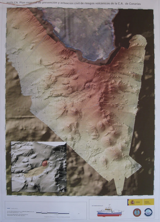
As with the southern coast of the island over recent weeks, an Oceanographic research vessel is due to arrive on the North of the Island to investigate and map the ocean floor in the El Golfo bay and to check for the likelihood of new volcanic vents being created.
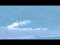
Meanwhile, the Las Calmas bay area, off the coast of La Restinga on the south of the island have seen a development with the volcanic eruptions over the weekend. A new vent appears to have opened up 1.8 km from the coast and this has been accompanied with a marked change in the colour of the stain, together with the emission of sulfurous gasses and the production of a number of smouldering volcanic rocks being brought to the surface of the water.
Maar je kan wel mooi zien hoe die vlekken en drijvende lava bommen ontstaan.

[ Bericht 9% gewijzigd door bwt op 29-11-2011 10:13:29 ]
<a href="http://goo.gl/q8fhTe" target="_blank">FAQ?</a>
<a href="http://goo.gl/gYvZFq" target="_blank">Geel is een zonnige en vrolijke kleur, als hij tenminste enigszins warm is gekleurd en wat naar het oranje neigt</a>
<a href="http://goo.gl/gYvZFq" target="_blank">Geel is een zonnige en vrolijke kleur, als hij tenminste enigszins warm is gekleurd en wat naar het oranje neigt</a>

Het mooie vind ik al die speculaties, niemand weet wat er nog gaat gebeuren.
Het zal allemaal wel met een sisser aflopen
Echt veel heftigs gebeurt er niet......
Het zal allemaal wel met een sisser aflopen
Echt veel heftigs gebeurt er niet......
Er is weer actie - nieuwe uitstoot / nieuwe vent?
Check de cams
Ook is het eerder vermelde onderzoeksschip aangekomen.
http://earthquake-report.com/2011/11/12/32535/
3 in 1 webcam pagina
[ Bericht 77% gewijzigd door bwt op 29-11-2011 11:59:14 ]
Check de cams
Ook is het eerder vermelde onderzoeksschip aangekomen.
http://earthquake-report.com/2011/11/12/32535/
3 in 1 webcam pagina
Een mooiere is die van de IGNquote:NOTE AVCAN 351 - EARTHQUAKE ACTIVITY-VOLCANIC - HIERRO ISLAND - 29 November 2011-11:45 h peninsular - seismic-volcanic activity continues to moderate-high, with seismicity in the Gulf marine area. Continue an important sign of volcanic tremor in the Restinga area, with an amplitude that has remained stable since the last note, and small oscillations and explosions, possibly hydromagmatic (by the way the pattern has repeated explosions every 2 hours approx). The magnitude of the earthquakes between 3.0 and 1.5. New quakes 7. Felt earthquakes 1. Depths to 16, 16, 17, 19, 20 and 23km. The day before yesterday 16. Yesterday 23. Today van 4. A total of 11,865 earthquakes are located in El Hierro by IGN from 9:00 am of July 19, 2011 (Enrique).
For those who are curious as will the "Devil's staircase" or energy ladder or evolution of the cumulative seismic energy released from 4.6 until today, I leave you there, with the last steps of the earthquakes of yesterday and today at the end. By the way the patterns are 48h, and two at each 6h-12h also (Enrique)


[ Bericht 77% gewijzigd door bwt op 29-11-2011 11:59:14 ]
<a href="http://goo.gl/q8fhTe" target="_blank">FAQ?</a>
<a href="http://goo.gl/gYvZFq" target="_blank">Geel is een zonnige en vrolijke kleur, als hij tenminste enigszins warm is gekleurd en wat naar het oranje neigt</a>
<a href="http://goo.gl/gYvZFq" target="_blank">Geel is een zonnige en vrolijke kleur, als hij tenminste enigszins warm is gekleurd en wat naar het oranje neigt</a>
Activiteit lijk weer afgenomen te zijn. Het onderzoekschip is ook weer net binnen/buiten het bereik van de webcams.
Ze zijn ook aardig met het in/uit zoomen bezig met de cams.
Ze zijn ook aardig met het in/uit zoomen bezig met de cams.
<a href="http://goo.gl/q8fhTe" target="_blank">FAQ?</a>
<a href="http://goo.gl/gYvZFq" target="_blank">Geel is een zonnige en vrolijke kleur, als hij tenminste enigszins warm is gekleurd en wat naar het oranje neigt</a>
<a href="http://goo.gl/gYvZFq" target="_blank">Geel is een zonnige en vrolijke kleur, als hij tenminste enigszins warm is gekleurd en wat naar het oranje neigt</a>
Onderzoeks bootje wat voorbij kwam is speciaal voor topografiequote:Decreased daily average depth, though, with only 4 events detected this day 29 half hour ago. The average weight is the result of energy released every event: Summary of the seismicity of day: 11/29/2011
Number of seismic events on the day: 4 at 11:10
Latitude weighted average energy released: 27,771
Average length weighted by energy released: 18,050
Depth-weighted average energy released: 15,416
Seismic energy released during the day: 10723049118099.76563 Joule
Equivalent Magnitude of the day: 3.0126
Average Energy per event day: 2680762279524.941407500 Joule
Average magnitude event of the day: 2,761
[bron]


[ Bericht 16% gewijzigd door bwt op 29-11-2011 12:33:19 ]
<a href="http://goo.gl/q8fhTe" target="_blank">FAQ?</a>
<a href="http://goo.gl/gYvZFq" target="_blank">Geel is een zonnige en vrolijke kleur, als hij tenminste enigszins warm is gekleurd en wat naar het oranje neigt</a>
<a href="http://goo.gl/gYvZFq" target="_blank">Geel is een zonnige en vrolijke kleur, als hij tenminste enigszins warm is gekleurd en wat naar het oranje neigt</a>
quote:The INVOLCAN continues to record an increase in the diffuse emission of CO2 by the volcanic system island of El Hierro
The diffuse emission of carbon dioxide (CO2), at present, the volcano island of El Hierro reaches 2398 ± 115 tons per day
Since last July, scientists at the Institute of Technology and Renewable Energies (ITER), an agency of the Cabildo of Tenerife, and is now part of volcanological Institute of the Canaries (non-tip) have conducted numerous scientific surveys of diffuse emissions volcanic gases that have materialized over the entire surface of the island of Isla Meridian. To date, the results reflect the record of an upward trend of the diffuse emission of carbon dioxide (CO2) into the atmosphere by the volcano island of El Hierro has reached 2398 ± 115 tons per day, an amount equivalent to almost 7 times the normal average value considered for the diffuse emission of carbon dioxide (CO2) in the island of El Hierro (345 tonnes per day).
This increase in the diffuse emission of carbon dioxide (CO2) shows that the pressure of carbon dioxide (CO2) in magmatic-hydrothermal system existing in the island of El Hierro is increasing probably due to magma movement from positions more shallow depth favoring exsolution of carbon dioxide (CO2) dissolved in silicate melts (magma).
The scientific purpose of these campaigns is to investigate spatio-temporal variations of the diffuse emission of carbon dioxide (CO2) into the atmosphere by the volcanic system of El Hierro island since the results thereof can not be obtained through networks permanent instrumental analysis contribute to the evolution of the current eruptive phase is occurring in El Hierro. On the other hand, it is widely accepted that the gases are the driving force of volcanic eruptions and the importance of carbon dioxide (CO2) in volcanic surveillance programs since not only is the second major component of volcanic gases, after steam but its low solubility in molten silicitados (magma) that favors carbon dioxide (CO2) to escape with their ease of volcanic systems in depth.
These scientific surveys have failed to materialize due to MAKAVOL project "Capacity Building of R + D + i + d to contribute to the reduction of volcanic risk in the Macaronesia (MAC/3/C161)" which is being co-funded by the Transnational Cooperation Programme of the European Union Madeira-Canary-Azores (MAC 2007-2013) and the collaboration of the Island Councils of Tenerife and El Hierro.
INVOLCAN is an institution demanded unanimously by the Senate (2005), Parliament of the Canary Islands (2006) and House of Representatives (2009) with the aim of contributing to improving and optimizing the management of volcanic risk in Spain.
Picture Pie
Temporal evolution of the diffuse emission of carbon dioxide (CO2) in the island of El Hierro (red circles) recorded by the Involcan and the daily number of earthquakes located by the National Seismic Network (IGN).

<a href="http://goo.gl/q8fhTe" target="_blank">FAQ?</a>
<a href="http://goo.gl/gYvZFq" target="_blank">Geel is een zonnige en vrolijke kleur, als hij tenminste enigszins warm is gekleurd en wat naar het oranje neigt</a>
<a href="http://goo.gl/gYvZFq" target="_blank">Geel is een zonnige en vrolijke kleur, als hij tenminste enigszins warm is gekleurd en wat naar het oranje neigt</a>
Bootje vaart nog steeds heen en weer voor de webcamsquote:Update 29/11 – 11:26 UTC
User Martin Rey has traced the ship currently navigating in the stain area
New oceanographic boat on La restinga th "Sarmiento de Gamboa".. 70m, its the BEST oceanographic boat that can be send, i think. It's called a "grand Cientific Instalation" by CSIC, its owner.
Update 29/11 12:18 UTC
It is not official, but due to the many ups and downs along the stain, we are almost sure that the Sarmiento de Gamboa is mapping the sea floor very carefully.
- Todays webcam image is rather complicated with a number of stains. We will need an image from a helicopter to find out whether these are Jacuzzis or patches of earlier emitted material.

[ Bericht 4% gewijzigd door bwt op 29-11-2011 15:06:59 ]
<a href="http://goo.gl/q8fhTe" target="_blank">FAQ?</a>
<a href="http://goo.gl/gYvZFq" target="_blank">Geel is een zonnige en vrolijke kleur, als hij tenminste enigszins warm is gekleurd en wat naar het oranje neigt</a>
<a href="http://goo.gl/gYvZFq" target="_blank">Geel is een zonnige en vrolijke kleur, als hij tenminste enigszins warm is gekleurd en wat naar het oranje neigt</a>
En ik weet niet of het volgende plaatje de nieuwe of oude situatie isquote:NOTE AVCAN 352 - EARTHQUAKE ACTIVITY-VOLCANIC - HIERRO ISLAND - 29 November 2011-22:00 h peninsular - seismic-volcanic activity continues to moderate-high, with seismicity in the Gulf marine area. Continue an important sign of volcanic tremor in the Restinga area, with an amplitude that has remained stable since the last note, and small oscillations and explosions, possibly hydromagmatic (by the way the pattern has repeated explosions ever closer, each hours approx). The magnitude of the earthquakes between 2.2 and 1.0. New earthquakes 4. Depths to 15, 16, 18 and 22km. The day before yesterday 16. Yesterday 23. Now go 8. A total of 11,869 earthquakes are located in El Hierro by IGN from 9:00 am of July 19, 2011 (Enrique).

<a href="http://goo.gl/q8fhTe" target="_blank">FAQ?</a>
<a href="http://goo.gl/gYvZFq" target="_blank">Geel is een zonnige en vrolijke kleur, als hij tenminste enigszins warm is gekleurd en wat naar het oranje neigt</a>
<a href="http://goo.gl/gYvZFq" target="_blank">Geel is een zonnige en vrolijke kleur, als hij tenminste enigszins warm is gekleurd en wat naar het oranje neigt</a>
Er zijn weer mooie plaatjes van gister - 29-11-2011
Zo zijn er ook mooie video's te vinden op de FB pagina's --- en hier de originele foto's
[ Bericht 3% gewijzigd door bwt op 30-11-2011 13:53:52 ]


Zo zijn er ook mooie video's te vinden op de FB pagina's --- en hier de originele foto's
[ Bericht 3% gewijzigd door bwt op 30-11-2011 13:53:52 ]
<a href="http://goo.gl/q8fhTe" target="_blank">FAQ?</a>
<a href="http://goo.gl/gYvZFq" target="_blank">Geel is een zonnige en vrolijke kleur, als hij tenminste enigszins warm is gekleurd en wat naar het oranje neigt</a>
<a href="http://goo.gl/gYvZFq" target="_blank">Geel is een zonnige en vrolijke kleur, als hij tenminste enigszins warm is gekleurd en wat naar het oranje neigt</a>


En de video's van het INVOLCAN Youtube kanaal
[ Bericht 2% gewijzigd door bwt op 30-11-2011 15:53:30 ]


[ Bericht 2% gewijzigd door bwt op 30-11-2011 15:53:30 ]
<a href="http://goo.gl/q8fhTe" target="_blank">FAQ?</a>
<a href="http://goo.gl/gYvZFq" target="_blank">Geel is een zonnige en vrolijke kleur, als hij tenminste enigszins warm is gekleurd en wat naar het oranje neigt</a>
<a href="http://goo.gl/gYvZFq" target="_blank">Geel is een zonnige en vrolijke kleur, als hij tenminste enigszins warm is gekleurd en wat naar het oranje neigt</a>
Ik zie zelfs pluimpjes omhoog schieten.
btw. er zijn weer nieuwe foto's - http://www.facebook.com/m(...)4042953295772&type=1
En hier ook foto's - http://www.facebook.com/m(...)4042953295772&type=1
btw. er zijn weer nieuwe foto's - http://www.facebook.com/m(...)4042953295772&type=1

En hier ook foto's - http://www.facebook.com/m(...)4042953295772&type=1

<a href="http://goo.gl/q8fhTe" target="_blank">FAQ?</a>
<a href="http://goo.gl/gYvZFq" target="_blank">Geel is een zonnige en vrolijke kleur, als hij tenminste enigszins warm is gekleurd en wat naar het oranje neigt</a>
<a href="http://goo.gl/gYvZFq" target="_blank">Geel is een zonnige en vrolijke kleur, als hij tenminste enigszins warm is gekleurd en wat naar het oranje neigt</a>
Nog steeds niet?
Ik zit de hele tijd te kijken.
Lijkt er op dat ik me net zoveel verveel als degene in het bootje, die varen ook maar heen en weer
http://earthquake-report.com/2011/11/12/32535/
webcam 2
Ik zit de hele tijd te kijken.
Lijkt er op dat ik me net zoveel verveel als degene in het bootje, die varen ook maar heen en weer
http://earthquake-report.com/2011/11/12/32535/
webcam 2
jij boefjequote:
Inorbit: zeg dat dan typluie triangeljosti
Beauregard: Een beetje FOK!ker laat het brood door z'n moeder smeren.
Ecosia
ek's 'n flash drive, jy's 'n floppy
Beauregard: Een beetje FOK!ker laat het brood door z'n moeder smeren.
Ecosia
ek's 'n flash drive, jy's 'n floppy

Als de webcam verbinding heeft kun je dit zo af en toe zien.
Camera lijkt het weer half te doen.
[ Bericht 4% gewijzigd door bwt op 01-12-2011 12:23:03 ]
<a href="http://goo.gl/q8fhTe" target="_blank">FAQ?</a>
<a href="http://goo.gl/gYvZFq" target="_blank">Geel is een zonnige en vrolijke kleur, als hij tenminste enigszins warm is gekleurd en wat naar het oranje neigt</a>
<a href="http://goo.gl/gYvZFq" target="_blank">Geel is een zonnige en vrolijke kleur, als hij tenminste enigszins warm is gekleurd en wat naar het oranje neigt</a>
Over vandaag
[google translate]
[ Bericht 19% gewijzigd door bwt op 01-12-2011 15:45:45 ]
[google translate]
1,5 uur in iets meer dan 4 minutenquote:The volcano of La Restinga eject large rocks again
The volcano has returned to La Restinga eject large chunks of solidified lava. The focus cameras 24 hours a bubbling area captured from the first morning, however, "were no more than 20 or 30 rocks" that emerged, says a spokeswoman for the National Geographic Institute (IGN), Carmen Lopez .
A IGN researchers did not give time to collect samples because they could not approach the area due to the strong prevailing wind and the rocks sank quickly, its large size. Carmen Lopez and IGN technicians arrived near the eruptive Salvamar aboard and found that washes out "smoking" in the midst of a "much bubbling" by the emission of "greenhouse and very fine and dense material."
The expulsion of solid material lasted less than two hours. At the moment only seen a bubble in the focal zone eruption.

[ Bericht 19% gewijzigd door bwt op 01-12-2011 15:45:45 ]
<a href="http://goo.gl/q8fhTe" target="_blank">FAQ?</a>
<a href="http://goo.gl/gYvZFq" target="_blank">Geel is een zonnige en vrolijke kleur, als hij tenminste enigszins warm is gekleurd en wat naar het oranje neigt</a>
<a href="http://goo.gl/gYvZFq" target="_blank">Geel is een zonnige en vrolijke kleur, als hij tenminste enigszins warm is gekleurd en wat naar het oranje neigt</a>
En er zijn weer nieuwe plaatjes op het picasa album van earthquake report.
en de originelen
[ Bericht 8% gewijzigd door bwt op 02-12-2011 09:45:33 ]

en de originelen
[ Bericht 8% gewijzigd door bwt op 02-12-2011 09:45:33 ]
<a href="http://goo.gl/q8fhTe" target="_blank">FAQ?</a>
<a href="http://goo.gl/gYvZFq" target="_blank">Geel is een zonnige en vrolijke kleur, als hij tenminste enigszins warm is gekleurd en wat naar het oranje neigt</a>
<a href="http://goo.gl/gYvZFq" target="_blank">Geel is een zonnige en vrolijke kleur, als hij tenminste enigszins warm is gekleurd en wat naar het oranje neigt</a>
bij mij werkt het probleemloos
http://hierroendirecto.movistar.es/
En nieuwe video - geluid uit want de heli maakt veel lawaai.
[ Bericht 72% gewijzigd door bwt op 02-12-2011 11:50:08 ]
http://hierroendirecto.movistar.es/
En nieuwe video - geluid uit want de heli maakt veel lawaai.

[ Bericht 72% gewijzigd door bwt op 02-12-2011 11:50:08 ]
<a href="http://goo.gl/q8fhTe" target="_blank">FAQ?</a>
<a href="http://goo.gl/gYvZFq" target="_blank">Geel is een zonnige en vrolijke kleur, als hij tenminste enigszins warm is gekleurd en wat naar het oranje neigt</a>
<a href="http://goo.gl/gYvZFq" target="_blank">Geel is een zonnige en vrolijke kleur, als hij tenminste enigszins warm is gekleurd en wat naar het oranje neigt</a>
Hoe je het ook bekijkt - het is de laatste paar dagen erg rustig rond de eruptie.
Bijna geen bevingen. Tremors die redelijk rustig zijn.
Als je ook kijkt naar de vervormingen dan lijkt alles weer terug naar normale waarden te keren.
Enige wat nog een beetje aanwezig blijft zijn de hogere CO2 waardes.
De bevingen van de laatste 36 uur. Zijn er niet veel
En van de afgelopen 4 dagen.
[ Bericht 44% gewijzigd door bwt op 03-12-2011 11:18:46 ]
Bijna geen bevingen. Tremors die redelijk rustig zijn.
Als je ook kijkt naar de vervormingen dan lijkt alles weer terug naar normale waarden te keren.
Enige wat nog een beetje aanwezig blijft zijn de hogere CO2 waardes.
De bevingen van de laatste 36 uur. Zijn er niet veel

En van de afgelopen 4 dagen.

quote:Graphic which aims to present each day as if there had been an earthquake and the earthquake alone would be equivalent to the sum of the rest of earthquakes a day.
This is to compare the energy released (presented as magnitude), with the average depth of daily events, the average magnitude of the events and the number of events have occurred in the day.
To calculate the average depth, it is weighted by the energy released by each event. (JR)
[bron]

[ Bericht 44% gewijzigd door bwt op 03-12-2011 11:18:46 ]
<a href="http://goo.gl/q8fhTe" target="_blank">FAQ?</a>
<a href="http://goo.gl/gYvZFq" target="_blank">Geel is een zonnige en vrolijke kleur, als hij tenminste enigszins warm is gekleurd en wat naar het oranje neigt</a>
<a href="http://goo.gl/gYvZFq" target="_blank">Geel is een zonnige en vrolijke kleur, als hij tenminste enigszins warm is gekleurd en wat naar het oranje neigt</a>
Het is rustig en rustiger en rustiger.
Zelfs geen bevingen sinds middernacht....
Zelfs geen bevingen sinds middernacht....
<a href="http://goo.gl/q8fhTe" target="_blank">FAQ?</a>
<a href="http://goo.gl/gYvZFq" target="_blank">Geel is een zonnige en vrolijke kleur, als hij tenminste enigszins warm is gekleurd en wat naar het oranje neigt</a>
<a href="http://goo.gl/gYvZFq" target="_blank">Geel is een zonnige en vrolijke kleur, als hij tenminste enigszins warm is gekleurd en wat naar het oranje neigt</a>
Maar tegelijkertijd is de vlek in het water nog steeds onverminderd actief. CO2 levels zijn ook nog steeds hoog.
Desondanks lijkt het het begin van het einde, aangezien de situatie ook minder veranderlijk is dan voorheen, nog los van het ontbreken van de aardbevingen
Desondanks lijkt het het begin van het einde, aangezien de situatie ook minder veranderlijk is dan voorheen, nog los van het ontbreken van de aardbevingen
een van de weinige dingen die vandaag gebeurd zijn, volgens earthquake report
Hoewel de tremors eind van de dag nog aan het opleven zijn gegaan.....
[ Bericht 23% gewijzigd door bwt op 04-12-2011 22:36:39 ]

Hoewel de tremors eind van de dag nog aan het opleven zijn gegaan.....

quote:NOTE AVCAN 362 - EARTHQUAKE ACTIVITY-VOLCANIC - HIERRO ISLAND - DECEMBER 04 2011-22:00 h peninsular - seismic-volcanic activity continues to moderate, with seismicity in the del Golfo marine area. Continue an important sign of volcanic tremor in the Restinga area, with an amplitude which remained stable since the last, least the last 2 hours starting at 7:50 p.m. or so where it has doubled in intensity by a possible jam in the pipe and swings and more explosions, possibly hydromagmatic. The magnitude of the earthquake only 1.4. New earthquakes 1. Depths at 17km. Before yesterday 5. Yesterday 3. Today van 2. A total of 11,909 earthquakes are located in El Hierro by IGN from 9:00 am of July 19, 2011 (Enrique).
[bron]
[ Bericht 23% gewijzigd door bwt op 04-12-2011 22:36:39 ]
<a href="http://goo.gl/q8fhTe" target="_blank">FAQ?</a>
<a href="http://goo.gl/gYvZFq" target="_blank">Geel is een zonnige en vrolijke kleur, als hij tenminste enigszins warm is gekleurd en wat naar het oranje neigt</a>
<a href="http://goo.gl/gYvZFq" target="_blank">Geel is een zonnige en vrolijke kleur, als hij tenminste enigszins warm is gekleurd en wat naar het oranje neigt</a>
En de treomors voor vandaag:

<a href="http://goo.gl/q8fhTe" target="_blank">FAQ?</a>
<a href="http://goo.gl/gYvZFq" target="_blank">Geel is een zonnige en vrolijke kleur, als hij tenminste enigszins warm is gekleurd en wat naar het oranje neigt</a>
<a href="http://goo.gl/gYvZFq" target="_blank">Geel is een zonnige en vrolijke kleur, als hij tenminste enigszins warm is gekleurd en wat naar het oranje neigt</a>

quote:The diffuse emission of CO2 by the volcanic system of El Hierro island falls under the INVOLCAN
This downward trend since late November until now arriving at 1560 ± 59 tonnes per day
Since last July, scientists at the Institute of Technology and Renewable Energies (ITER), an agency of the Cabildo of Tenerife, and is now part of volcanological Institute of the Canaries (INVOLCAN) have conducted numerous scientific surveys of diffuse emissions volcanic gases that have materialized over the entire surface of the island of Isla Meridian. The results show a downward trend in the diffuse emission of carbon dioxide (CO2) into the atmosphere by the volcano island of El Hierro since late November, when it came to achieving the 2398 ± 115 tons per day, up to now been recorded an emission rate of 1,560 ± 59 tonnes per day.
This record to the bottom of the diffuse emission of carbon dioxide (CO2) in turn implies that the pressure of carbon dioxide (CO2) in volcanic-magmatic system existing in the hydrothermal-island of El Hierro should not continue to grow as well it might be inferred during the observation period was experiencing an increase in the diffuse emission of carbon dioxide (CO2).
The scientific purpose of these campaigns is to investigate spatio-temporal variations of the diffuse emission of carbon dioxide (CO2) into the atmosphere by the volcanic system of El Hierro island since the results thereof can not be obtained through networks permanent instrumental analysis contribute to the evolution of the current eruptive phase is occurring in El Hierro. On the other hand, it is widely accepted that the gases are the driving force of volcanic eruptions and monitoring of carbon dioxide (CO2) in volcanic surveillance programs is very important because not only is the second major component of volcanic gases after water vapor, but also because of its low solubility in molten silicitados (magma) favoring the carbon dioxide (CO2) to escape with their ease of volcanic systems in depth.
These scientific surveys have failed to materialize due to MAKAVOL project "Capacity Building of R + D + i + d to contribute to the reduction of volcanic risk in the Macaronesia (MAC/3/C161)" which is being co-funded by the Transnational Cooperation Programme of the European Union Madeira-Canary-Azores (MAC 2007-2013) and the collaboration of the Island Councils of Tenerife and El Hierro.
INVOLCAN is an institution demanded unanimously by the Senate (2005), Parliament of the Canary Islands (2006) and House of Representatives (2009) with the aim of contributing to improving and optimizing the management of volcanic risk in Spain.
Picture Pie
Temporal evolution of the diffuse emission of carbon dioxide (CO2) in the island of El Hierro (red circles) recorded by the non-tip and the daily number of earthquakes located by the National Seismic Network (IGN).
[bron]
<a href="http://goo.gl/q8fhTe" target="_blank">FAQ?</a>
<a href="http://goo.gl/gYvZFq" target="_blank">Geel is een zonnige en vrolijke kleur, als hij tenminste enigszins warm is gekleurd en wat naar het oranje neigt</a>
<a href="http://goo.gl/gYvZFq" target="_blank">Geel is een zonnige en vrolijke kleur, als hij tenminste enigszins warm is gekleurd en wat naar het oranje neigt</a>
Mijn bovenstaande plaatje geeft het al aan.
quote:The Involcan shows a decrease in the diffuse emission of CO2 by the volcanic system
Scientists at the Institute of Technology and Renewable Energies (ITER), an agency of the Cabildo of Tenerife, and is now part of volcanological Institute of the Canaries (Involcan), indicate a downward trend of the diffuse emission of carbon dioxide (CO2) into the atmosphere by the volcano island of El Hierro since late November, when it came to achieving the 2398 ± 115 tons per day, up to now been recorded an emission rate of 1,560 ± 59 tonnes per day.
This record to the bottom of the diffuse emission of CO2 in turn implies that the pressure of CO2 in the system magmatic-hydrothermal volcanic-existing in the island "should not continue to grow as well it might be inferred during the period of observation was experiencing an increase in the diffuse emission of CO2. "
The Involcan said in a statement that the purpose of these campaigns is to investigate scientific spatiotemporal variations of the diffuse emission of carbon dioxide into the atmosphere by the volcanic system since the results can not be obtained through permanent instrumental network developments contribute to the analysis of the current eruptive phase is occurring in El Hierro.
[bron]
<a href="http://goo.gl/q8fhTe" target="_blank">FAQ?</a>
<a href="http://goo.gl/gYvZFq" target="_blank">Geel is een zonnige en vrolijke kleur, als hij tenminste enigszins warm is gekleurd en wat naar het oranje neigt</a>
<a href="http://goo.gl/gYvZFq" target="_blank">Geel is een zonnige en vrolijke kleur, als hij tenminste enigszins warm is gekleurd en wat naar het oranje neigt</a>
De nieuwe webcam:
http://www.rtvc.es/volcanelhierro/volcanendirecto.aspx
En de 3 reeds bekende webcams
http://earthquake-report.com/2011/11/12/32535/
http://www.rtvc.es/volcanelhierro/volcanendirecto.aspx
En de 3 reeds bekende webcams
http://earthquake-report.com/2011/11/12/32535/
<a href="http://goo.gl/q8fhTe" target="_blank">FAQ?</a>
<a href="http://goo.gl/gYvZFq" target="_blank">Geel is een zonnige en vrolijke kleur, als hij tenminste enigszins warm is gekleurd en wat naar het oranje neigt</a>
<a href="http://goo.gl/gYvZFq" target="_blank">Geel is een zonnige en vrolijke kleur, als hij tenminste enigszins warm is gekleurd en wat naar het oranje neigt</a>
De beelden van gister

<a href="http://goo.gl/q8fhTe" target="_blank">FAQ?</a>
<a href="http://goo.gl/gYvZFq" target="_blank">Geel is een zonnige en vrolijke kleur, als hij tenminste enigszins warm is gekleurd en wat naar het oranje neigt</a>
<a href="http://goo.gl/gYvZFq" target="_blank">Geel is een zonnige en vrolijke kleur, als hij tenminste enigszins warm is gekleurd en wat naar het oranje neigt</a>
En de tremors voor vandaag

<a href="http://goo.gl/q8fhTe" target="_blank">FAQ?</a>
<a href="http://goo.gl/gYvZFq" target="_blank">Geel is een zonnige en vrolijke kleur, als hij tenminste enigszins warm is gekleurd en wat naar het oranje neigt</a>
<a href="http://goo.gl/gYvZFq" target="_blank">Geel is een zonnige en vrolijke kleur, als hij tenminste enigszins warm is gekleurd en wat naar het oranje neigt</a>


Waar zit nu die vilkaan onderwater???
Hier dus:
Hier dus:
<a href="http://goo.gl/q8fhTe" target="_blank">FAQ?</a>
<a href="http://goo.gl/gYvZFq" target="_blank">Geel is een zonnige en vrolijke kleur, als hij tenminste enigszins warm is gekleurd en wat naar het oranje neigt</a>
<a href="http://goo.gl/gYvZFq" target="_blank">Geel is een zonnige en vrolijke kleur, als hij tenminste enigszins warm is gekleurd en wat naar het oranje neigt</a>

Gister avond tussen 21:00 en 22:00 toch weer wat toename in de tremors.
Mogelijk dat er weer wat verassingen aan komen.
- The coincidence of the high H2S levels with the very strong harmonic tremor has to be looked at. A pity we could not see the Las Calmas sea at night. The high values may have been triggered by a very strong Jacuzzi activity.
- The picture below shows a very long lasting burst of activity that started at 21:26 UTC and lasted for about 20 minutes. The signal decreased gradually thereafter but stayed stronger than before the burst
- 2 earthquakes today with epicenter in the El Golfo Bay.
Momenteel weer mooie rookpluimen te zien boven het water.
http://earthquake-report.com/2011/11/12/32535/
http://earthquake-report.com/2011/11/12/32535/
<a href="http://goo.gl/q8fhTe" target="_blank">FAQ?</a>
<a href="http://goo.gl/gYvZFq" target="_blank">Geel is een zonnige en vrolijke kleur, als hij tenminste enigszins warm is gekleurd en wat naar het oranje neigt</a>
<a href="http://goo.gl/gYvZFq" target="_blank">Geel is een zonnige en vrolijke kleur, als hij tenminste enigszins warm is gekleurd en wat naar het oranje neigt</a>
Tremor verdwenen
quote:Update 08/12 – 07:18 UTC
- Harmonic tremor subsided to one of the lowest levels since the eruption started on October 10. After a period of very strong bursts who started yesterday at 22:00 a sudden collapse of harmonic tremor occurred at 04:24 UTC early this morning. We expect that the vent has collapsed due to the strong activity since yesterday evening.
What will happen now ?
–1– As we had almost no earthquakes anymore since many days and as we had only medium harmonic tremor, the chance that the activity was subsiding completely looked real. If this is the case, the earthquakes will not pickup again and the eruption will be over.
–2– If the magma is still very active below El Hierro and as it can not find an opening any longer via the vent, the earthquakes will gradually pickup again from now on. The pace that this happens will give a clue to scientists how much power to expect.
het bijbehorende plaatje van het verdwijnen van de tremors
VUELO CIENTÃFICO INVOLCAN - GC 291111 - VOLCÃN SUBMARINO DEL HIERRO - SARMIENTO DE GAMBOA - PANCAM
[ Bericht 40% gewijzigd door bwt op 08-12-2011 10:06:17 ]

Beelden van 7-12-2011quote:Spains National Geological Institute (IGN) Scientists, observing seismic and volcanic activity on the Canary Island of El Hierro have recorded just 2 earthquakes over the course of the last 24 Hours (14.00 hrs Tuesday - 14.00 hrs GMT Wednesday).
Activity has fallen considerably over the last week, with Earthquakes numbering between 2 and 4 per week, compared with an average of 12 per day around one month ago.
As in previous days and weeks, these two Earthquakes took place in and around the El Golfo bay area, off the coast of Frontera to the north of the Island. The Magnitudes recorded registered 1.6 and 1.9 on the richter scale, at depths of 23km and 15km respectively.
Meanwhile, scientists observing the underwater Volcanic eruptions in the Las Calmas bay area, off the coast of La Restinga on the south of the island have told PEVOLCA that the temperature of the sea around the `jacuzzi is beginning to stabilize. Temperatures peaked on the 6th of November with a maximum recording of 30.9 Degrees, but have now returned to an average of 21.3 Degrees.
[bron]

VUELO CIENTÃFICO INVOLCAN - GC 291111 - VOLCÃN SUBMARINO DEL HIERRO - SARMIENTO DE GAMBOA - PANCAM
[ Bericht 40% gewijzigd door bwt op 08-12-2011 10:06:17 ]
<a href="http://goo.gl/q8fhTe" target="_blank">FAQ?</a>
<a href="http://goo.gl/gYvZFq" target="_blank">Geel is een zonnige en vrolijke kleur, als hij tenminste enigszins warm is gekleurd en wat naar het oranje neigt</a>
<a href="http://goo.gl/gYvZFq" target="_blank">Geel is een zonnige en vrolijke kleur, als hij tenminste enigszins warm is gekleurd en wat naar het oranje neigt</a>
ps. ik merk dat ik de OP niet meer kan aanpassen.
Er zijn een een aantal plaatjes die een 403 forbidden opleveren en ik wilde nog wat linkjes toevoegen.
Er zijn een een aantal plaatjes die een 403 forbidden opleveren en ik wilde nog wat linkjes toevoegen.
<a href="http://goo.gl/q8fhTe" target="_blank">FAQ?</a>
<a href="http://goo.gl/gYvZFq" target="_blank">Geel is een zonnige en vrolijke kleur, als hij tenminste enigszins warm is gekleurd en wat naar het oranje neigt</a>
<a href="http://goo.gl/gYvZFq" target="_blank">Geel is een zonnige en vrolijke kleur, als hij tenminste enigszins warm is gekleurd en wat naar het oranje neigt</a>
Het lijkt er toch sterk op dat we een back building hebben op de tremors...
- We wrote the 07:18 update when it was still dark
- Reader Max wrote in our comments at 07:33 : Well, regardless of tremor changes, smoking lava stones are still coming up to the surface at 7:30 camera time. It’s still ongoing.
- and …. indeed tremor is gradually picking up again = the eruption continues

Lava blocks komen nog altijd naar boven:

quote:NOTE AVCAN 369 - EARTHQUAKE ACTIVITY-VOLCANIC - HIERRO ISLAND - DECEMBER 08 2011-12:00 h peninsular - seismic-volcanic activity continues to moderate, with seismicity in the Gulf marine area. Continue an important sign of volcanic tremor in the Restinga area, with high amplitude, unstable and some explosions, possibly even at 04:30 h hydromagmatic where under almost minimum and since then tends to rise and become unstable again. Today has been smoldering pyroclastic output from early in the morning. The magnitude of the earthquake only 1.8. New earthquakes 1. Depth to 22 km. Before yesterday 2. Yesterday 2. Today they 1. A total of 11,919 earthquakes are located in El Hierro by IGN from 9:00 am of July 19, 2011 (Enrique).
[bron]
<a href="http://goo.gl/q8fhTe" target="_blank">FAQ?</a>
<a href="http://goo.gl/gYvZFq" target="_blank">Geel is een zonnige en vrolijke kleur, als hij tenminste enigszins warm is gekleurd en wat naar het oranje neigt</a>
<a href="http://goo.gl/gYvZFq" target="_blank">Geel is een zonnige en vrolijke kleur, als hij tenminste enigszins warm is gekleurd en wat naar het oranje neigt</a>
Qua bevingen is het wel erg rustig
Energie opbouw/ontlading - bevingen
Bevingen laatste 36 uur
[ Bericht 56% gewijzigd door bwt op 08-12-2011 14:21:39 ]
Energie opbouw/ontlading - bevingen
Bevingen laatste 36 uur
quote:Slightly increase the tremor and the stain of La Restinga
The National Geographic Institute (IGN) has confirmed the Civil Protection Plan for Volcanic Risk (Pevolca) yesterday only two earthquakes were located in the area of the Gulf, northwest of La Frontera, with magnitudes of 1.9 and 1.6 on the Richter scale at a depth of 15 and 17 kilometers respectively. None of them was felt by the population. In total, since the day July 17, 2011 11 926 events have been found.
According to IGN, the level of tremor increased in amplitude around 22:00 hours, at which time there was a greater pulse length. Since then remained stable at a level slightly higher than the beginning of the day. As for the studies of ground deformation during the day yesterday continued the same pattern of distortion of previous days, reflecting stability in the components horizontal and vertical component deflation of all stations in the south and east of the island regard to the stain of La Restinga, it is noteworthy that there was an episodic emission steaming lava fragments, but of much less importance than the previous day . IGN adds that the vessel 'Adhara' Maritime Rescue attempted to collect samples but it was not possible due to the remoteness of the area in the emerging area with clean water surface. The spot had a large area throughout the day.
[ Bericht 56% gewijzigd door bwt op 08-12-2011 14:21:39 ]
<a href="http://goo.gl/q8fhTe" target="_blank">FAQ?</a>
<a href="http://goo.gl/gYvZFq" target="_blank">Geel is een zonnige en vrolijke kleur, als hij tenminste enigszins warm is gekleurd en wat naar het oranje neigt</a>
<a href="http://goo.gl/gYvZFq" target="_blank">Geel is een zonnige en vrolijke kleur, als hij tenminste enigszins warm is gekleurd en wat naar het oranje neigt</a>
klopt - alles lijkt stabiel te worden. Dus saaier en steeds minder te melden - En dat wat er is is meer van het zelfde.
The volcano of La Restinga, # ElHierro has three cones attached to each other
The volcano of La Restinga, # ElHierro has three cones attached to each other
<a href="http://goo.gl/q8fhTe" target="_blank">FAQ?</a>
<a href="http://goo.gl/gYvZFq" target="_blank">Geel is een zonnige en vrolijke kleur, als hij tenminste enigszins warm is gekleurd en wat naar het oranje neigt</a>
<a href="http://goo.gl/gYvZFq" target="_blank">Geel is een zonnige en vrolijke kleur, als hij tenminste enigszins warm is gekleurd en wat naar het oranje neigt</a>
ik wacht op een daverend slotstuk
Inorbit: zeg dat dan typluie triangeljosti
Beauregard: Een beetje FOK!ker laat het brood door z'n moeder smeren.
Ecosia
ek's 'n flash drive, jy's 'n floppy
Beauregard: Een beetje FOK!ker laat het brood door z'n moeder smeren.
Ecosia
ek's 'n flash drive, jy's 'n floppy
De lava bol die dreef van de eerdere foto op video vast gelegd:
even blijven kijken voor het resultaat......
even blijven kijken voor het resultaat......

<a href="http://goo.gl/q8fhTe" target="_blank">FAQ?</a>
<a href="http://goo.gl/gYvZFq" target="_blank">Geel is een zonnige en vrolijke kleur, als hij tenminste enigszins warm is gekleurd en wat naar het oranje neigt</a>
<a href="http://goo.gl/gYvZFq" target="_blank">Geel is een zonnige en vrolijke kleur, als hij tenminste enigszins warm is gekleurd en wat naar het oranje neigt</a>
Niet helemaal duidelijk of het nu infrarood is of niet.quote:NOTE AVCAN 370 - EARTHQUAKE ACTIVITY-VOLCANIC - HIERRO ISLAND - DECEMBER 08 2011-23:00 h peninsular - seismic-volcanic activity continues to moderate. Continue an important sign of volcanic tremor in the Restinga area, with high amplitude, unstable and some explosions, possibly even at 04:30 h hydromagmatic where under almost to a minimum and since then tends to rise and become unstable again, making more consistent in the last hours. Today has been smoldering pyroclastic output from early in the morning. No new earthquakes today at Hierro and vicinity. Before yesterday 2. Yesterday 2. Today they 1. A total of 11,919 earthquakes are located in El Hierro by IGN from 9:00 am of July 19, 2011 (Enrique).

<a href="http://goo.gl/q8fhTe" target="_blank">FAQ?</a>
<a href="http://goo.gl/gYvZFq" target="_blank">Geel is een zonnige en vrolijke kleur, als hij tenminste enigszins warm is gekleurd en wat naar het oranje neigt</a>
<a href="http://goo.gl/gYvZFq" target="_blank">Geel is een zonnige en vrolijke kleur, als hij tenminste enigszins warm is gekleurd en wat naar het oranje neigt</a>
gezien de helderheid zou ik zeggen van wel...quote:Op vrijdag 9 december 2011 09:11 schreef bwt het volgende:
[..]
Niet helemaal duidelijk of het nu infrarood is of niet.
[ afbeelding ]
Inorbit: zeg dat dan typluie triangeljosti
Beauregard: Een beetje FOK!ker laat het brood door z'n moeder smeren.
Ecosia
ek's 'n flash drive, jy's 'n floppy
Beauregard: Een beetje FOK!ker laat het brood door z'n moeder smeren.
Ecosia
ek's 'n flash drive, jy's 'n floppy
paar interessante plaatjes gevonden (via twitter) op http://www.montecruz.es/
[ Bericht 42% gewijzigd door bwt op 09-12-2011 09:49:20 ]


quote:NOTE AVCAN 371 - EARTHQUAKE ACTIVITY-VOLCANIC - HIERRO ISLAND - DECEMBER 09 2011-09:00 h peninsular - seismic-volcanic activity continues to moderate, with seismicity in the Gulf marine area. Continue an important sign of volcanic tremor in the Restinga area, with an amplitude that remains slightly higher and slightly unstable and some explosions, possibly hydromagmatic. The magnitude of the earthquakes between 2.0 and 1.8 New earthquakes 2. Depths to 21 and 23km. Before yesterday 2. Yesterday 2. Today they 1. A total of 11,921 earthquakes are located in El Hierro by IGN from 9:00 am of July 19, 2011 (Enrique).
[ Bericht 42% gewijzigd door bwt op 09-12-2011 09:49:20 ]
<a href="http://goo.gl/q8fhTe" target="_blank">FAQ?</a>
<a href="http://goo.gl/gYvZFq" target="_blank">Geel is een zonnige en vrolijke kleur, als hij tenminste enigszins warm is gekleurd en wat naar het oranje neigt</a>
<a href="http://goo.gl/gYvZFq" target="_blank">Geel is een zonnige en vrolijke kleur, als hij tenminste enigszins warm is gekleurd en wat naar het oranje neigt</a>
Scientific flights Involcan - POLICE HELICOPTER ON SUBMARINE VOLCANO AREA OF RESTINGA IN THE SOUTH OF IRON IN THE MORNING OF THE DAY NOVEMBER 8, 2011, MEASURING DISSOLVED GASES IN THE AIR ON THE ERUPTION ZONE HEAT AND TAKING PICTURES . EVOLUTION OF THE SHIP OF OCEANOGRAPHIC INSTITUTE SPANISH "Ramon Margalef" IN THE AREA OF ISSUE UNDERWATER, ULTRASOUND PERFORMING bathymetry and the seabed.

<a href="http://goo.gl/q8fhTe" target="_blank">FAQ?</a>
<a href="http://goo.gl/gYvZFq" target="_blank">Geel is een zonnige en vrolijke kleur, als hij tenminste enigszins warm is gekleurd en wat naar het oranje neigt</a>
<a href="http://goo.gl/gYvZFq" target="_blank">Geel is een zonnige en vrolijke kleur, als hij tenminste enigszins warm is gekleurd en wat naar het oranje neigt</a>
quote:What to expect next ?
Based on Mr. Armas interview and taking into account a number of uncertainties, Earthquake-Report.com expects that :
- if the eruption continues at the present rate and in the same vent, it will take max. 2 weeks to arrive at a depth less than 100 meter. We than expect very strong Jacuzzis during the hydromagmatic bursts.
- if the same process continues for about 3 to 4 weeks and in the same vent we expect regular hydrovolcanic explosions during the bursts.
- if the same process goes on 5 to 6 weeks the eruption may become Surtseyan. This is the most spectacular phase of the eruption. During this phase of the eruption ash and steam clouds can reach hundreds of meters to several km in height. Particular to Surtseyan eruptions are the thick,dark-pointed jets of fragments, often headed by bombs, shot out of the vent.
- if the same process goes on 7 to 8 weeks and in the same vent, the eruption will have created at least a new island
- the main vent is at a safe distance from La Restinga, so we do not see immediate danger for the population. 90% of the time the wind blows from the north or north east at this time of the year and accordingly the eventual ash will be blown further in the Las Calmas sea, avoiding damage at La Restinga..
- If a new island forms, it may indicate several months of uncertainty for the La Restinga population as nobody knows how long the eruption will last and when it will finally stop for a longer time as there may be several new eruptive periods.
Our expectation is based on medium harmonic tremor like we had the last couple of days. In case of strong or very strong harmonic tremor the time to get to these different phases may well be a lot shorter.
If our expectations are coming true, the eruption will make El Hierro appearing in every news show in the world. The island will start to attract visitors from all over the world.
In januari ga ik een weekje naar Tenerife, vandaar uit een dagje naar El Hierro met de veerboot.
Genoeg te zien tegen die tijd als ik de post hierboven moet geloven
Genoeg te zien tegen die tijd als ik de post hierboven moet geloven
Moet zeggen dat die onderwaterwater explosies (magma en water mixen waardoor water stoom wordt en onder zeer grote druk ontsnapt) goed te zien zijn op de tremors.
De volgende is minder duidelijk.
Maar als je per uur kijkt weer wel.
Qua echte bevingen is het wel erg rustig - slechts 4 in de afgelopen 36 uur

De volgende is minder duidelijk.

Maar als je per uur kijkt weer wel.

Qua echte bevingen is het wel erg rustig - slechts 4 in de afgelopen 36 uur
<a href="http://goo.gl/q8fhTe" target="_blank">FAQ?</a>
<a href="http://goo.gl/gYvZFq" target="_blank">Geel is een zonnige en vrolijke kleur, als hij tenminste enigszins warm is gekleurd en wat naar het oranje neigt</a>
<a href="http://goo.gl/gYvZFq" target="_blank">Geel is een zonnige en vrolijke kleur, als hij tenminste enigszins warm is gekleurd en wat naar het oranje neigt</a>
Maar dan moet je wel gaan eiland hoppen met vliegtuig of boot.quote:
In januari ga ik een weekje naar Tenerife, vandaar uit een dagje naar El Hierro met de veerboot.
Genoeg te zien tegen die tijd als ik de post hierboven moet geloven
Vanaf tenerife zul je er niets van merken/zien
<a href="http://goo.gl/q8fhTe" target="_blank">FAQ?</a>
<a href="http://goo.gl/gYvZFq" target="_blank">Geel is een zonnige en vrolijke kleur, als hij tenminste enigszins warm is gekleurd en wat naar het oranje neigt</a>
<a href="http://goo.gl/gYvZFq" target="_blank">Geel is een zonnige en vrolijke kleur, als hij tenminste enigszins warm is gekleurd en wat naar het oranje neigt</a>
Hij zegt toch ook dat hij een dagje El Hierro gaat doen?quote:
[..]
Maar dan moet je wel gaan eiland hoppen met vliegtuig of boot.
Vanaf tenerife zul je er niets van merken/zien
In this world of evil and darkness I'm looking for the one girl that has the power to bring light into my heart. A light so pure that my evil thoughts about this world and the people living on it will vanish and I'll finally experience true love.
Precies, ferry van Los Cristianos op Tenerife naar El Hierro.
Tegen die tijd even uitzoeken hoe het vervoer op El Hierro is geregeld, zal vast wel meer belangstellende trekken deze gebeurtenis
Tegen die tijd even uitzoeken hoe het vervoer op El Hierro is geregeld, zal vast wel meer belangstellende trekken deze gebeurtenis
Och en anders ga je zwemmen :-)
Door de jacuzzie!
Door de jacuzzie!
Inorbit: zeg dat dan typluie triangeljosti
Beauregard: Een beetje FOK!ker laat het brood door z'n moeder smeren.
Ecosia
ek's 'n flash drive, jy's 'n floppy
Beauregard: Een beetje FOK!ker laat het brood door z'n moeder smeren.
Ecosia
ek's 'n flash drive, jy's 'n floppy

Ik ben gewoon scheel.................................quote:
[..]
Hij zegt toch ook dat hij een dagje El Hierro gaat doen?
<a href="http://goo.gl/q8fhTe" target="_blank">FAQ?</a>
<a href="http://goo.gl/gYvZFq" target="_blank">Geel is een zonnige en vrolijke kleur, als hij tenminste enigszins warm is gekleurd en wat naar het oranje neigt</a>
<a href="http://goo.gl/gYvZFq" target="_blank">Geel is een zonnige en vrolijke kleur, als hij tenminste enigszins warm is gekleurd en wat naar het oranje neigt</a>
Anyway. Er blijven in iedergeval weer veel tremors door de mix van lava en water...


<a href="http://goo.gl/q8fhTe" target="_blank">FAQ?</a>
<a href="http://goo.gl/gYvZFq" target="_blank">Geel is een zonnige en vrolijke kleur, als hij tenminste enigszins warm is gekleurd en wat naar het oranje neigt</a>
<a href="http://goo.gl/gYvZFq" target="_blank">Geel is een zonnige en vrolijke kleur, als hij tenminste enigszins warm is gekleurd en wat naar het oranje neigt</a>
Ofwel, niets wijst erop dat de uitbarsting voorbij is.quote:As a matter of fact, most eruptions are preceded by earthquakes, but in most cases the earthquakes stop once the eruption has reached a stable regime. The stopping of earthquakes does not mean that the eruption will stop anytime soon, the eruption might continue for years after the end of significant earthquake activity. Earthquakes are indicative of breaking rocks, caused by magma pushing into areas where there is no established conduit.
Once a stable magma flow occurs through a well-established conduit, there will be no longer any earthquakes.
The cessation of earthquakes only means that the situation has somehow stabilized, not that magma is ceasing to flow.
The real indicator of continued magma flow is volcanic tremor.
Only once the volcanic tremor disappears, then one might reasonably argue that the eruption is over.
- The jacuzzi has been active to very active all day long. The harmonic tremor graph is showing that the eruption is continuing at a steady pace and accordingly that the vent is growing.
- If the process continues at the current level, we expect that one of the coming weeks or even days, the steam bubbles will reach the air and if the vent remains open, the steam will gradually go higher.
- Currently bursts lasting 2 to 4 minutes are occurring every 8 minutes (see picture below for the current time frame).

Deze ochtend is de jacuzzi weer duidelijk aanwezig.
Ook is nu op de http://earthquake-report.com/2011/11/12/32535/ site duidelijk te zien dat er een IR-camera in gebruik is. Wel zo mooi als het geweld wel gaat beginnen.
Ook is nu op de http://earthquake-report.com/2011/11/12/32535/ site duidelijk te zien dat er een IR-camera in gebruik is. Wel zo mooi als het geweld wel gaat beginnen.
quote:NOTE AVCAN 376 - EARTHQUAKE ACTIVITY-VOLCANIC - IRON ISLAND - DECEMBER 11 2011-22:00 h peninsular - seismic-volcanic activity continues to moderate, with seismicity in the Gulf marine area. Continue an important sign of volcanic tremor in the Restinga area, with an amplitude that remains upward (trend in which the last 72 hours and where the intensity has doubled) and presents a growing number explosions, possibly hydromagmatic, every few minutes, a typical strombolian behavior for which establishes a balance between water inlet and outlet of gases in the exhaust duct so that it pulses like a geyser. No new earthquakes located. Before yesterday 2. Yesterday 0. Today is 1. A total of 11,923 earthquakes are located in El Hierro by IGN from 9:00 am of July 19, 2011 (Enrique).
<a href="http://goo.gl/q8fhTe" target="_blank">FAQ?</a>
<a href="http://goo.gl/gYvZFq" target="_blank">Geel is een zonnige en vrolijke kleur, als hij tenminste enigszins warm is gekleurd en wat naar het oranje neigt</a>
<a href="http://goo.gl/gYvZFq" target="_blank">Geel is een zonnige en vrolijke kleur, als hij tenminste enigszins warm is gekleurd en wat naar het oranje neigt</a>
De kans dat we wel wat gaan zien bovenwater komt steeds dichterbij. Mocht dit aanhouden dan denk ik dat de beelden op de webcams er een stuk spannender zullen uitzien.
- NO earthquakes and the eruption continues at the same pace since a couple of days. Harmonic tremor with very strong bursts goes on.
- Very visible stain and Jacuzzi on the webcam (a pity as the eruption webcam has not yet zoomed in). This process will intensify the coming hours, days and weeks as the erupting vent gradually climbs higher. The webcam also shows regular white patches (stronger turbulence NO SLS’s).
- Some people think that if they do not see SLS (Smoking Lava Stones), the eruption is decreasing. This is not the case, the SLS floating on the water in earlier days and weeks are ultralight ash blocks.
- Most of the lava coming out of the vent / crater is pāhoehoe lava (Hawaiian word characterizing most of the lava found on the Hawaiian islands). A pāhoehoe flow typically advances as a series of small lobes and toes that continually break out from a cooled crust. It also forms lava tubes where the minimal heat loss maintains low viscosity. The surface texture of pāhoehoe flows varies widely, displaying all kinds of bizarre shapes often referred to as lava sculpture. We will shortly write an update zooming in on the characteristics of this lava type.
- Joke just told us that Jacuzzi and stain can well be seen from El Pinar, higher on the island. Joke did return to her own house at El Pinar from yesterday afternoon.


Jaja dit klopt wel:
. The webcam also shows regular white patches
Enig idee hoe ver de vulkaan nu onder het oppervlakte ligt?
Laatst wat ik gelezen heb was 70 meter.
. The webcam also shows regular white patches
Enig idee hoe ver de vulkaan nu onder het oppervlakte ligt?
Laatst wat ik gelezen heb was 70 meter.
volgens mij nog 150 meter hoor...quote:Op maandag 12 december 2011 12:14 schreef 1boefje het volgende:
Jaja dit klopt wel:
. The webcam also shows regular white patches
Enig idee hoe ver de vulkaan nu onder het oppervlakte ligt?
Laatst wat ik gelezen heb was 70 meter.
Inorbit: zeg dat dan typluie triangeljosti
Beauregard: Een beetje FOK!ker laat het brood door z'n moeder smeren.
Ecosia
ek's 'n flash drive, jy's 'n floppy
Beauregard: Een beetje FOK!ker laat het brood door z'n moeder smeren.
Ecosia
ek's 'n flash drive, jy's 'n floppy
ergens stond dat er vanaf nu ongeveer 8 weken nodig was om dat stuk te overbruggen. Dus tenzij je zwaar terminaal bent zou het evenuteel nog wel binnen je levensverwachting mogen gebeuren ;-)quote:
Ah, die zie ik dus in mijn leven niet meer boven water komenweer een waste of time
Inorbit: zeg dat dan typluie triangeljosti
Beauregard: Een beetje FOK!ker laat het brood door z'n moeder smeren.
Ecosia
ek's 'n flash drive, jy's 'n floppy
Beauregard: Een beetje FOK!ker laat het brood door z'n moeder smeren.
Ecosia
ek's 'n flash drive, jy's 'n floppy
quote:
Hahaha, laten we dan maar hopen dat er niks tussen komt
Zou het graag zien gebeuren!
quote:- if the same process continues for about 3 to 4 weeks and in the same vent we expect regular hydrovolcanic explosions during the bursts.
- if the same process goes on 5 to 6 weeks the eruption may become Surtseyan. This is the most spectacular phase of the eruption. During this phase of the eruption ash and steam clouds can reach hundreds of meters to several km in height. Particular to Surtseyan eruptions are the thick,dark-pointed jets of fragments, often headed by bombs, shot out of the vent.
- if the same process goes on 7 to 8 weeks and in the same vent, the eruption will have created at least a new island
Inorbit: zeg dat dan typluie triangeljosti
Beauregard: Een beetje FOK!ker laat het brood door z'n moeder smeren.
Ecosia
ek's 'n flash drive, jy's 'n floppy
Beauregard: Een beetje FOK!ker laat het brood door z'n moeder smeren.
Ecosia
ek's 'n flash drive, jy's 'n floppy
5 weken geleden zat de krater op 150 meter diepte. Volgens de berichten zou er nog inderdaad een 7 of 8 weken voor nodig zijn om een eiland te vormen. Dat betekend dat als ik goed reken er totaal een 13 weken voor nodig zijn. De krater groeit 11,5 meter per week meer naar de oppervlakte. Het komt er op neer dat we vanaf die 5 weken nu bijna 60 meter hoger zitten. Dus deze zit waarschijnlijk ongeveer op een 90 meter onder de zeespiegel.
Dus ja de 70 meter zou nog wel eens waar kunnen zijn wanneer de lavastroom toch iets is toegenomen. De druk van het water is uiteraard ook minder geworden. Dus ja. Nogmaals de 70 meter zou wel eens waar kunnen zijn.
[ Bericht 6% gewijzigd door kcgaga op 12-12-2011 14:22:07 ]
Dus ja de 70 meter zou nog wel eens waar kunnen zijn wanneer de lavastroom toch iets is toegenomen. De druk van het water is uiteraard ook minder geworden. Dus ja. Nogmaals de 70 meter zou wel eens waar kunnen zijn.
[ Bericht 6% gewijzigd door kcgaga op 12-12-2011 14:22:07 ]
10 pagina's leesvoerquote:Update 12/12 -13:57 UTC
- As we are currently in a submarine eruption phase with hydromagmatic bursts, we have searched and found a scientific study about such action. In 1984 Kenneth H. Wohletz and Robert McQueen from the USA Los Alamas National Laboratory wrote a paper with the title : “Experimental Studies of Hydromagmatic Volcanism“ [PDF]. We encourage people who want to learn more details about the current phenomena, to read (at least some parts) of this article.
[ Bericht 1% gewijzigd door bwt op 12-12-2011 15:54:26 ]
<a href="http://goo.gl/q8fhTe" target="_blank">FAQ?</a>
<a href="http://goo.gl/gYvZFq" target="_blank">Geel is een zonnige en vrolijke kleur, als hij tenminste enigszins warm is gekleurd en wat naar het oranje neigt</a>
<a href="http://goo.gl/gYvZFq" target="_blank">Geel is een zonnige en vrolijke kleur, als hij tenminste enigszins warm is gekleurd en wat naar het oranje neigt</a>
Hydromagmatic burtst, toevallig mijn vakgebied...

Inorbit: zeg dat dan typluie triangeljosti
Beauregard: Een beetje FOK!ker laat het brood door z'n moeder smeren.
Ecosia
ek's 'n flash drive, jy's 'n floppy
Beauregard: Een beetje FOK!ker laat het brood door z'n moeder smeren.
Ecosia
ek's 'n flash drive, jy's 'n floppy
quote:NOTE AVCAN 377 - EARTHQUAKE ACTIVITY-VOLCANIC - HIERRO ISLAND - DECEMBER 12 2011-11:00 h peninsular - seismic-volcanic activity continues to moderate, with seismicity in the Gulf marine area. Continue an important sign of volcanic tremor in the Restinga area, with a base noise amplitude is maintained upward (trend in which the last 3.5 days and where the intensity has doubled) and ... presents a increasing number of explosions, possibly hydromagmatic every few minutes strombolian typical behavior for which establishes a balance between water inlet and outlet of gases in the exhaust duct so that it pulses like a geyser. No new earthquakes located. Before yesterday 0. Yesterday 1. Now go 0. A total of 11,923 earthquakes are located in El Hierro by IGN from 9:00 am of July 19, 2011 (Enrique).
Mooi plaatje van vanmorgen dus.quote:Update 12/12 -14:58 UTC
The amazing NASA Satellite MODIS picture taken at 11:55 UTC this morning (3 hours ago) is showing a cloud column on the exact place of the vent towards the island. Even we do not believe it ! Is must be a coincidence and if not than we have detected the steaming vent waters. The image cannot have been photoshopped as it has been extracted directly from the NASA website (thanks to Julio del Castillo Rivero for sending us the NASA link).
[ Bericht 33% gewijzigd door bwt op 12-12-2011 16:14:14 ]
<a href="http://goo.gl/q8fhTe" target="_blank">FAQ?</a>
<a href="http://goo.gl/gYvZFq" target="_blank">Geel is een zonnige en vrolijke kleur, als hij tenminste enigszins warm is gekleurd en wat naar het oranje neigt</a>
<a href="http://goo.gl/gYvZFq" target="_blank">Geel is een zonnige en vrolijke kleur, als hij tenminste enigszins warm is gekleurd en wat naar het oranje neigt</a>

cool filmpje
Inorbit: zeg dat dan typluie triangeljosti
Beauregard: Een beetje FOK!ker laat het brood door z'n moeder smeren.
Ecosia
ek's 'n flash drive, jy's 'n floppy
Beauregard: Een beetje FOK!ker laat het brood door z'n moeder smeren.
Ecosia
ek's 'n flash drive, jy's 'n floppy
Tremors voor vandaag:quote:First day free of eruptions and earthquakes in El Hierro since the summer
FOR the first time since July 17, a whole day has gone by with no eruptions off the island of El Hierro and no earthquakes recorded.
Since the summer, there have been an incredible 11,930 earthquakes on the island.
At its most active, the earth movement led to tremors every five to 10 minutes throughout the day.
Although bubbles were seen on the surface of the water off the coast of La Restinga, no volcanic emissions were observed from the crater under the sea for the first time in nearly five months.
At present, the UK Foreign Office advises against all travel to the La Restinga area of El Hierro as a precaution.

quote:NOTE AVCAN 378 - EARTHQUAKE ACTIVITY-VOLCANIC - HIERRO ISLAND - DECEMBER 12 2011-22:00 h peninsular - seismic-volcanic activity continues to moderate, with seismicity in the del Golfo marine area. Continue an important sign of volcanic tremor in the Restinga area, with an amplitude that remains (4 days was higher and more than doubled its intensity), presents numerous explosions, possibly hydromagmatic every few minutes, which establishes a balance between water inlet and outlet of gases in the exhaust duct so that it pulses like a geyser. Stronger remarkable explosion at 14:59 has been felt in the Restinga. No new earthquakes located. Before yesterday 0. Yesterday 1. Now go 0. A total of 11,923 earthquakes are located in El Hierro by IGN from 9:00 am of July 19, 2011 (Enrique).
<a href="http://goo.gl/q8fhTe" target="_blank">FAQ?</a>
<a href="http://goo.gl/gYvZFq" target="_blank">Geel is een zonnige en vrolijke kleur, als hij tenminste enigszins warm is gekleurd en wat naar het oranje neigt</a>
<a href="http://goo.gl/gYvZFq" target="_blank">Geel is een zonnige en vrolijke kleur, als hij tenminste enigszins warm is gekleurd en wat naar het oranje neigt</a>
Mooi filmpje 
Gaat geloof ik bij El Hierro niet gebeuren (daar gaat mn reisje in het voorjaar).
Ze hebben het de hele tijd over die wolk die zich vormt. Ik heb het gisteren ook gezien op de webcam (tot de zon kwam). Kan zoiets niet ontstaan door de warmte die de vulkaan veroorzaakt? Het water in de omgeving van de uitbarsting wordt continu verwarmt.
[ Bericht 40% gewijzigd door 1boefje op 13-12-2011 09:15:33 ]
35 minuten vergelijk tussen tremors en "the stain"

<a href="http://goo.gl/q8fhTe" target="_blank">FAQ?</a>
<a href="http://goo.gl/gYvZFq" target="_blank">Geel is een zonnige en vrolijke kleur, als hij tenminste enigszins warm is gekleurd en wat naar het oranje neigt</a>
<a href="http://goo.gl/gYvZFq" target="_blank">Geel is een zonnige en vrolijke kleur, als hij tenminste enigszins warm is gekleurd en wat naar het oranje neigt</a>
Zeg nooit nooit. Als dit zo doorgaat als nu, denk ik dat het wel zal gebeuren.quote:
Mooi filmpje
Gaat geloof ik bij El Hierro niet gebeuren (daar gaat mn reisje in het voorjaar).
Ze hebben het de hele tijd over die wolk die zich vormt. Ik heb het gisteren ook gezien op de webcam (tot de zon kwam). Kan zoiets niet ontstaan door de warmte die de vulkaan veroorzaakt? Het water in de omgeving van de uitbarsting wordt continu verwarmt.
Wat betreft het ontstaan van de wolk. Ik heb hem zelf ook gezien. Er zal ongetwijfeld meer waterdamp en CO2 uit de vent ontsnappen. Maar of dit genoeg is om een eigen wolk te produceren is maar net de vraag. Daarvoor zullen ze toch echt een meting in het water moeten gaan doen.
Dan zal er tegen die tijd wel meer te zien zijn denk ik. Maar zeer waarschijnlijk nog geen vulkaan boven het water uit.quote:
Hij moet wel opschieten dan, want vanaf 2 januari zal ik weer werken
quote:Op - The RTVC webcam is showing a very turbulent Jacuzzi activity. The hydromagmatic bursts are having a growing impact on the surface waters and more than once the water is bulging.


Als je de tremors, en zo, van de IGN site haalt dan hoef je alleen maar een page refresh op fok te doen om de nieuwe info hier op de site te zien.
<a href="http://goo.gl/q8fhTe" target="_blank">FAQ?</a>
<a href="http://goo.gl/gYvZFq" target="_blank">Geel is een zonnige en vrolijke kleur, als hij tenminste enigszins warm is gekleurd en wat naar het oranje neigt</a>
<a href="http://goo.gl/gYvZFq" target="_blank">Geel is een zonnige en vrolijke kleur, als hij tenminste enigszins warm is gekleurd en wat naar het oranje neigt</a>
Klopt inderdaad. Dat scheelt een hoop dubbele informatie.quote:
Als je de tremors, en zo, van de IGN site haalt dan hoef je alleen maar een page refresh op fok te doen om de nieuwe info hier op de site te zien.
Het lijkt er nu toch sterk op dat de webcams een nevel van gas zien. Toch steeds meer bewijs dat de "vent" steeds dichter bij komt en actiever aan de oppervlakte gaat worden.
Mede een behoorlijke burst gemeten op 13:10 (zie boven).
Mede een behoorlijke burst gemeten op 13:10 (zie boven).

Lekkere tremor net :-)
Inorbit: zeg dat dan typluie triangeljosti
Beauregard: Een beetje FOK!ker laat het brood door z'n moeder smeren.
Ecosia
ek's 'n flash drive, jy's 'n floppy
Beauregard: Een beetje FOK!ker laat het brood door z'n moeder smeren.
Ecosia
ek's 'n flash drive, jy's 'n floppy
Ja en daarna is gloeiend materiaal gezien aan het oppervlak (denken ze).
Gaat er misschien toch nog wat vuurwerk komen.......
Deze ochtend is het weer erg rustig.
[ Bericht 15% gewijzigd door 1boefje op 14-12-2011 09:36:07 ]
Gaat er misschien toch nog wat vuurwerk komen.......
Deze ochtend is het weer erg rustig.
[ Bericht 15% gewijzigd door 1boefje op 14-12-2011 09:36:07 ]
We zullen de grafiekjes er weer even bij zetten voor vandaag...
[ Bericht 25% gewijzigd door kcgaga op 14-12-2011 10:04:38 ]


[ Bericht 25% gewijzigd door kcgaga op 14-12-2011 10:04:38 ]
Er is in iedergeval genoeg activiteit die niet direct zichtbaar is maar wel belangrijk.
[ Bericht 3% gewijzigd door bwt op 14-12-2011 10:01:14 ]
quote:Important Update 14/12 – 08:21
The air analysis station shows some (important ?) changes at 08:00
SO2 NO2 NOX
8:00 12 6 15
7:00 7 2 4
6:00 6 2 3
Update 14/12 – 08:05 UTC
The eruption webcam shows smoking material this morning !
Data Update 14/12 – 07:44 UTC
- At 04:02 UTC an earthquake occurred at a depth of only 2 km ! in the El Golfo bay. Click here to see the map with the epicenter. This may be a totally new development if this happens again. The distance to the coast is approx. 5 km (thats the good news). The earthquake has NOT altered the hydromagmatic explosions in the Las Calmas sea.
- Harmonic tremor is still medium with slightly less bursts, although these bursts remain very powerful.
Very Important Update 14/12 – 06:40 UTC
Julio was not resting before he was certain that the light he recorded wasn’t traced back to the exact location. He superposed two images and scaled them so it would coincide with the port location and position. The effect is amazing. The flashlight really came from the vent and because of the distance it must have been a couple of meters high. Of course it can still be a boat, but we do not believe in that scenario as Julio looked at the other recordings later and NO boat was seen in the area. Julio will check his recordings during the morning hours to find out if new similar events might have occurred. The light must have been meters high based on the distance from the webcam (the webcam was not zoomed at the time)
Hot glowing material seen just before midnight ??
Julio del Castillo Vivero surprised us by uploading a short video recorded just before midnight
The video is showing after 11 seconds some object lighting up in the sea and a couple of seconds later another one lighting up. Is it a boat ?? We don’t think so, especially the second object shows a light which is extinguishing smoothly.
And the glowing material make sense if we see the very powerful burst just before midnight (graph below the video)


[ Bericht 3% gewijzigd door bwt op 14-12-2011 10:01:14 ]
<a href="http://goo.gl/q8fhTe" target="_blank">FAQ?</a>
<a href="http://goo.gl/gYvZFq" target="_blank">Geel is een zonnige en vrolijke kleur, als hij tenminste enigszins warm is gekleurd en wat naar het oranje neigt</a>
<a href="http://goo.gl/gYvZFq" target="_blank">Geel is een zonnige en vrolijke kleur, als hij tenminste enigszins warm is gekleurd en wat naar het oranje neigt</a>
Inderdaad, een onderwatervulkaan is toch voornamelijk onder water
de jacuzzi lijkt nu op dit moment iets actiever......
de jacuzzi lijkt nu op dit moment iets actiever......
Dit zijn wel weer mooie ontwikkelingen.
Maar het onderstaande is ook wel merkwaardig.
The air analysis station shows some (important ?) changes at 08:00
SO2 NO2 NOX
8:00 12 6 15
7:00 7 2 4
6:00 6 2 3
Maar het onderstaande is ook wel merkwaardig.
The air analysis station shows some (important ?) changes at 08:00
SO2 NO2 NOX
8:00 12 6 15
7:00 7 2 4
6:00 6 2 3


<a href="http://goo.gl/q8fhTe" target="_blank">FAQ?</a>
<a href="http://goo.gl/gYvZFq" target="_blank">Geel is een zonnige en vrolijke kleur, als hij tenminste enigszins warm is gekleurd en wat naar het oranje neigt</a>
<a href="http://goo.gl/gYvZFq" target="_blank">Geel is een zonnige en vrolijke kleur, als hij tenminste enigszins warm is gekleurd en wat naar het oranje neigt</a>
Oftewel - de sensors op La Palma registreren het woon- werk- en ander verkeer ipv echte tremors....quote:NOTE AVCAN 380 - EARTHQUAKE ACTIVITY-VOLCANIC - HIERRO ISLAND - DECEMBER 13 2011-22:15 h peninsular - seismic-volcanic activity continues to moderate, without seismicity localized, but with some weak event (03:08, 03:26, 07: 34 and 11:08 h). Continue an important sign of volcanic tremor in the Restinga area, with an amplitude that has gone up in the last hours, presents numerous explosions, possibly hydromagmatic every few minutes, which establishes a balance between water inlet and the output of gases in the exhaust duct so that it pulses like a geyser. What seems is that they are closer together. No new earthquakes located. Before yesterday 0. Yesterday 1. Now go 0. A total of 11,923 earthquakes are located in El Hierro by IGN from 9:00 am of July 19, 2011 (Enrique).
Today, a curiositie is the spectrogram of la Palma a compendium of human activities and some echo of the swarm Herro. Aircraft and works, but mostly works, working hours and stop for lunch .. is amazing and we so about a month .. so nobody worry if you see the throngs of the sensor signals that blew up ...

<a href="http://goo.gl/q8fhTe" target="_blank">FAQ?</a>
<a href="http://goo.gl/gYvZFq" target="_blank">Geel is een zonnige en vrolijke kleur, als hij tenminste enigszins warm is gekleurd en wat naar het oranje neigt</a>
<a href="http://goo.gl/gYvZFq" target="_blank">Geel is een zonnige en vrolijke kleur, als hij tenminste enigszins warm is gekleurd en wat naar het oranje neigt</a>
quote:
- The Ustream webcam shows an active wave area who is far much bigger than the preceding days.
- Harmonic tremor is VERY strong at the moment. Some bursts are lasting 5 minutes or more
- The new 09:00 air analysis values are the following :
SO2 decrease to 6
NO2 increase to 9
NOX increase to 18
[ Bericht 28% gewijzigd door kcgaga op 14-12-2011 10:20:50 ]
Vannacht wel een erg ondiepe beving geweest. (gecorrigeerd van 2 naar 21 KM diepte en van 1.9 naar 2.1 magnitude)
1117225 14/12/2011 04:02:49 27.8702 -18.0659 21 2.1 4 NW FRONTERA.IHI
Locatie: googlemaps
[ Bericht 22% gewijzigd door bwt op 14-12-2011 13:22:45 ]
1117225 14/12/2011 04:02:49 27.8702 -18.0659 21 2.1 4 NW FRONTERA.IHI
Locatie: googlemaps
quote:NOTE AVCAN 381 - EARTHQUAKE ACTIVITY-VOLCANIC - HIERRO ISLAND - DECEMBER 14 2011-11:00 h peninsular - seismic-volcanic activity continues to moderate, with seismicity in the Gulf marine area. Continue an important sign of volcanic tremor in the Restinga area, with an amplitude that has gone up in the last hours, presents numerous explosions, possibly hydromagmatic every few minutes, which establishes a balance between water inlet and the output of gases in the exhaust duct so that it pulses like a geyser. What seems is that more often alternating with periods of peridos less, but more intense. The magnitude of the earthquake only 1.9. New earthquakes 1. 2km depth. Before yesterday 0. Yesterday 0. Today they 1. A total of 11,924 earthquakes are located in El Hierro by IGN from 9:00 am of July 19, 2011 (Enrique)
[ Bericht 22% gewijzigd door bwt op 14-12-2011 13:22:45 ]
<a href="http://goo.gl/q8fhTe" target="_blank">FAQ?</a>
<a href="http://goo.gl/gYvZFq" target="_blank">Geel is een zonnige en vrolijke kleur, als hij tenminste enigszins warm is gekleurd en wat naar het oranje neigt</a>
<a href="http://goo.gl/gYvZFq" target="_blank">Geel is een zonnige en vrolijke kleur, als hij tenminste enigszins warm is gekleurd en wat naar het oranje neigt</a>
en een ander (zelfde) berichtquote:You will shortly see the light of volcanological Institute initiative de Canarias (INVOLCAN) and the Cabildo Insular de El Hierro with co-sponsorship of Civic Banking CajaCanarias in order to provide a bit more on the task of helping the community Herreño in these difficult times. This is a 29x29cm calendar with some snapshots of the underwater eruption south of La Restinga selflessly ceded by members of INVOLCAN and the Helicopter Unit of the Guardia Civil in the Canaries. With a circulation of 10,000 copies and a price of 10 euros / unit, 50% of the profits will go entirely to the community El Hierro, while the other 50% will go to the implementation of educational and training programs on volcanic phenomena volcanic risk management in the Canaries. If you want to collaborate and buy the calendar you can write an email to calendarioelhierro2012@gmail.com. The price does not include shipping.
[bron]
Oftewel - koop de calenderquote:From AVCAN want to support the maximum dissemination of this initiative as it says aims to provide some help to the community of El Hierro in these difficult times. A charity calendar. Who among us did not want some of those snapshots to save for the future? It's time once again to remember our friends in El Hierro. We applaud the initiative. You can order it on calendarioelhierro2012@gmail.com for only 10 euros. (Fernando)
[bron]

<a href="http://goo.gl/q8fhTe" target="_blank">FAQ?</a>
<a href="http://goo.gl/gYvZFq" target="_blank">Geel is een zonnige en vrolijke kleur, als hij tenminste enigszins warm is gekleurd en wat naar het oranje neigt</a>
<a href="http://goo.gl/gYvZFq" target="_blank">Geel is een zonnige en vrolijke kleur, als hij tenminste enigszins warm is gekleurd en wat naar het oranje neigt</a>
Nasa's Modis sateliet foto van vandaag volgens earthquake report
Plaatje een beetej bij gekleurd door peter vd woude
En een timelapse vanaf 16:53 tot 17:10
Merk nu dat de maker van het filmpje heeft zitten typen en zo tijdens het maken van dat filmpje.
Wel heftige achtie volgens de tremors tussen 18 en 19 uur (canaria time)
Ben benieuwd naar het volgende uur
Whaaa, het is in het donker te zien - zoals die ene van het filmpje gister rond middernacht.
Maar nu is het redelijk veel - dus de tremors zorgen voor onderwater vuurwerk.....
En wij kunnen mee kijken. (die kleine vlekjes ja die niet zo opvallen in het zwart van de zee...)
[ Bericht 19% gewijzigd door bwt op 14-12-2011 20:46:33 ]
Plaatje een beetej bij gekleurd door peter vd woude

En een timelapse vanaf 16:53 tot 17:10

Merk nu dat de maker van het filmpje heeft zitten typen en zo tijdens het maken van dat filmpje.
Wel heftige achtie volgens de tremors tussen 18 en 19 uur (canaria time)

Ben benieuwd naar het volgende uur

Whaaa, het is in het donker te zien - zoals die ene van het filmpje gister rond middernacht.
Maar nu is het redelijk veel - dus de tremors zorgen voor onderwater vuurwerk.....
En wij kunnen mee kijken. (die kleine vlekjes ja die niet zo opvallen in het zwart van de zee...)
quote:Update 14/12 19:28 UTC
Thise people wanting to see the hot stones rising up to the Las Calmas sea, please take a look at the La Restinga village webcam. Enjoy the volcano at night ! Thanks to Robert Sommerville for attracting our attention to it.
[ Bericht 19% gewijzigd door bwt op 14-12-2011 20:46:33 ]
<a href="http://goo.gl/q8fhTe" target="_blank">FAQ?</a>
<a href="http://goo.gl/gYvZFq" target="_blank">Geel is een zonnige en vrolijke kleur, als hij tenminste enigszins warm is gekleurd en wat naar het oranje neigt</a>
<a href="http://goo.gl/gYvZFq" target="_blank">Geel is een zonnige en vrolijke kleur, als hij tenminste enigszins warm is gekleurd en wat naar het oranje neigt</a>
Echt je kan op de ene een klein iellig lichtje zien (eruption cam)
en op de ander een rood knipperend lichtje (panorama cam)
http://earthquake-report.com/2011/11/12/32535/
de overzichts pagina met beide cams....
De panorama cam lijkt nu ook meer ingezoomd
en op de ander een rood knipperend lichtje (panorama cam)
http://earthquake-report.com/2011/11/12/32535/
de overzichts pagina met beide cams....
De panorama cam lijkt nu ook meer ingezoomd
<a href="http://goo.gl/q8fhTe" target="_blank">FAQ?</a>
<a href="http://goo.gl/gYvZFq" target="_blank">Geel is een zonnige en vrolijke kleur, als hij tenminste enigszins warm is gekleurd en wat naar het oranje neigt</a>
<a href="http://goo.gl/gYvZFq" target="_blank">Geel is een zonnige en vrolijke kleur, als hij tenminste enigszins warm is gekleurd en wat naar het oranje neigt</a>
Nouja, niet alleen rood. Ik zie ook blauw, groen, geel, paars en oranje voorbij komenquote:
Echt je kan op de ene een klein iellig lichtje zien (eruption cam)
en op de ander een rood knipperend lichtje (panorama cam)
http://earthquake-report.com/2011/11/12/32535/
de overzichts pagina met beide cams....
De panorama cam lijkt nu ook meer ingezoomd
Mijn vriendin kijkt me aan den denkt - ja, lichtjes.............quote:
[..]
Nouja, niet alleen rood. Ik zie ook blauw, groen, geel, paars en oranje voorbij komen
SPOILEROm spoilers te kunnen lezen moet je zijn ingelogd. Je moet je daarvoor eerst gratis Registreren. Ook kun je spoilers niet lezen als je een ban hebt.* bwt en nu weer serieus
Dit lijkt me echt meer de gloed van de lava onder het zee oppervlak.
Ben nu wel echt heel benieuwd hoe (on)diep die krater zit.
Misschien wel dichterbij dan we denken.
Dat zou in iedergeval verklaren waarom de heli en boten niet meer bij het bubbelbad komen.<a href="http://goo.gl/q8fhTe" target="_blank">FAQ?</a>
<a href="http://goo.gl/gYvZFq" target="_blank">Geel is een zonnige en vrolijke kleur, als hij tenminste enigszins warm is gekleurd en wat naar het oranje neigt</a>
quote:
[..]
Mijn vriendin kijkt me aan den denkt - ja, lichtjes.............Sja, kerstboomverlichting geeft inderdaad veel meer lichtSPOILEROm spoilers te kunnen lezen moet je zijn ingelogd. Je moet je daarvoor eerst gratis Registreren. Ook kun je spoilers niet lezen als je een ban hebt.Lijkt vooral een geldkwestie te zijn:quote:
* bwt en nu weer serieus
Dit lijkt me echt meer de gloed van de lava onder het zee oppervlak.
Ben nu wel echt heel benieuwd hoe (on)diep die krater zit.
Misschien wel dichterbij dan we denken.
Dat zou in iedergeval verklaren waarom de heli en boten niet meer bij het bubbelbad komen.SPOILEROm spoilers te kunnen lezen moet je zijn ingelogd. Je moet je daarvoor eerst gratis Registreren. Ook kun je spoilers niet lezen als je een ban hebt.
[ Bericht 13% gewijzigd door Tokamak op 14-12-2011 21:39:54 ]
Ah €€€€ dus.
Maare - wie riep dit?
Maare - wie riep dit?
<a href="http://goo.gl/q8fhTe" target="_blank">FAQ?</a>
<a href="http://goo.gl/gYvZFq" target="_blank">Geel is een zonnige en vrolijke kleur, als hij tenminste enigszins warm is gekleurd en wat naar het oranje neigt</a>
<a href="http://goo.gl/gYvZFq" target="_blank">Geel is een zonnige en vrolijke kleur, als hij tenminste enigszins warm is gekleurd en wat naar het oranje neigt</a>
tbh, het lijkt totaal niet op een schip, maar ik denk (helaas) dat het best wel eens waar kan zijnquote:Update 14/12 – 20:53 UTC – burning material is a hoax, in other words a ship.
Joke just cell phoned me that the people going to check it say that it is an ship (un barco).
Also we are thinking now that it is a ship (what is this ship doing there ???). Reason : the lights are just moving to the left at a steady pace. So, we are 95% sure that Joke just told us the truth.
Overreacting, yes and no.
Our many readers were sending comments and so many other people also saw the lights on the webcam. The image was convincing as one could see many patches of flames in the ocean. What we found strange at the beginning is that the village webcam had NO fires only with a lot of very faint points of light.
IGN (Carmen Lopez) was very right from the very beginning.
Joke told us a little earlier that some people had seen a ship at the lighthouse earlier tonight (these things are being told now).
IGN maybe sure that a lot of people are taking care of El Hierro by looking frequently at the webcam.
Video van vannacht.
begint vanaf 1:16 leuk te worden.
En de tremors lijken duidelijk sterker te worden.
[ Bericht 22% gewijzigd door bwt op 15-12-2011 08:46:10 ]
begint vanaf 1:16 leuk te worden.

En de tremors lijken duidelijk sterker te worden.

[ Bericht 22% gewijzigd door bwt op 15-12-2011 08:46:10 ]
<a href="http://goo.gl/q8fhTe" target="_blank">FAQ?</a>
<a href="http://goo.gl/gYvZFq" target="_blank">Geel is een zonnige en vrolijke kleur, als hij tenminste enigszins warm is gekleurd en wat naar het oranje neigt</a>
<a href="http://goo.gl/gYvZFq" target="_blank">Geel is een zonnige en vrolijke kleur, als hij tenminste enigszins warm is gekleurd en wat naar het oranje neigt</a>
Jammer, missed the show. Zette gisteravond ook even de webcam op, maar zal niks meer dan zwart.
Maar wat een discussie of het nu een schip is ja of te nee............pfff.......
Het is gewoon een UFO
Als het burning material is zoals ze het zo mooi omschrijven dan zullen ze het de komende tijd wel vaker waarnemen.
Deze ochtend is het rustig met de jacuzzi.
Maar wat een discussie of het nu een schip is ja of te nee............pfff.......
Het is gewoon een UFO
Als het burning material is zoals ze het zo mooi omschrijven dan zullen ze het de komende tijd wel vaker waarnemen.
Deze ochtend is het rustig met de jacuzzi.
quote:15/12/2011 @ 09:01 – The IGN has confirmed the stabilisation of the underwater eruptive process in shallow waters to the south of La Restinga as there is a marked decrease in seismicity, reaching the lowest values since the eruptive process began on 10th October 2011. They have said that in the current situation is not considered necessary to maintain constant 24 hour surveillance. It will continue monitoring the activity and its assessment in terms of scenarios, and the issuance of periodic reports and decision making.
quote:Update 15/12 – 08:04 UTC
PEVOLCA will stop its 24 hours surveillance in La Restinga but the Center for Permanent Care (CAP) will stay open at La Restinga from 08:00 until 20:00 daily. In between 20:00 and 08:00, people will have the possibility to call a guard able to give answers to most questions or urgencies. Pevolca (based on the data delivered from IGN) says that there is NO indication the the process is deteriorating or is becoming more dangerous. IGN reported the eruption process to be stabilized.
Pevolca also said that if whatever new indication of a reactivation will be noticed, they will return to 24 hour surveillance instantly. The decision has no influence on the alert levels currently in place at the Island (yellow alert at the entire island and red alert in a radius around the Las Calmas sea vent).
Earthquake-Report.com who follows the eruption process from the very beginning confirms that the IGN prognosis have always been right until now, although it was often criticized. The alerts were initially called for the landslide risks and the weak to moderate earthquakes in the El Golfo and Puerto Naos areas and as it was not sure in which area the volcano would show up (since the beginning of the eruption on October 10, there were never other vents localized except the line of the current vent (multiple vents at the beginning of November along the Naos coast). (source Joke Volta and the local press)
Data Update 15/12 – 07:59 UTC
- NO earthquakes since midnight
- very strong rise in general harmonic tremor at 01:21 UTC tonight. 40 minutes later back to medium. Bursts as intensive and as much as yesterday. Longest bursts lasted almost 10 minutes
- vent outlet is very defined this morning due to the strong westerly current
- IGN said yesterday that some bursts of harmonic tremor are being felt by local people in La Restinga
- stain as usual
Direct er boven meld Armand dat het inderdaad een bot moet zijn geweest en dat lezers de herkomst hebben kunnen achterhalen - later een uitgebreider bericht.quote:The nightly burning boat the final word of a volcanologist
Hmmm. I have carefully watched the videos of the strange lights recorded by the web cams on the evening of 14 December, and I am more than ever convinced that they are absolutely NOT related to volcanic activity, take a volcanologists word for it. The way the lights are moving from about 02:30 min in the second (shorter) of the night videos is clearly indicative of a ship. Theres no way in the physical word that incandescent rock will remain persistently incandescent when its in the middle of water, any piece of incandescent rock would be chilled and lose its incandescence at least on the surface.
Boris Behncke from the INGV-Osservatorio Etneo, Catania
[bron]
Op de Webcam is een erg duidelijke jacuzzi te zien.
http://earthquake-report.com/2011/11/12/32535/
En de tremors vallen in het laatste uur ook in eens terug. geen pieken meer van de jacuzzi?

[ Bericht 8% gewijzigd door bwt op 15-12-2011 16:06:30 ]
<a href="http://goo.gl/q8fhTe" target="_blank">FAQ?</a>
<a href="http://goo.gl/gYvZFq" target="_blank">Geel is een zonnige en vrolijke kleur, als hij tenminste enigszins warm is gekleurd en wat naar het oranje neigt</a>
<a href="http://goo.gl/gYvZFq" target="_blank">Geel is een zonnige en vrolijke kleur, als hij tenminste enigszins warm is gekleurd en wat naar het oranje neigt</a>
En het misterie ontrafeld?
[ Bericht 6% gewijzigd door bwt op 15-12-2011 17:50:06 ]
quote:Update 15/12 – 08:04 UTC – Why a ship ?
- As you all know IGN almost immediately said that is was a boat. The reason why will be explained a little later in an interview we will publish from Joke Volta with Carmen Lopez, chief scientist of IGN at El Hierro.
- People of El Pinar went to the viewpoint and said also “it is ‘probably’ a boat“.
- Joke talked to a number of people and they said that they had seen a boat at the Lighthouse horizon of the Las Calmas sea.
- Next, Joke looked with her binoculars from El Pinar high above the sea and could see some lights at the horizon.
As Joke knows the location of the vent very well, she was more or less convinced that it could not have been the vent but what else than a boat. The location of the webcams is totally different as they are installed on a hill near La Restinga. We @ ER started looking into to real time navigation maps, but we could not detect a ship to the south of El Hierro.
- This morning she saw this boat again and she started looking in the internet for the name and position. She made a picture this morning and indicated the different positions she saw it (see image below).
- Paul, a ER reader traced the boat this morning on Marinetraffic.com and on http://www.localizatodo.com . The ship was recognized as the C-Whale (see picture below). Paul also said that the only reason we have not seen this ship on the map during the evening and nightly hours must have been that it had switched off his transponders. Why ? Why was it hanging around in that area ? What was he burning ? It does not look like they had a barbecue on board. Nobody knows.
All other questions (easy to come up with more than 5 immediately) will never be solved.
Once again thanks to all for cooperating on this issue. This story has now been finalized.


quote:Data Update 15/12 15:30 UTC
- NO earthquakes since midnight below or around El Hierro
- OGN has a 1.7 earthquake listed, but the epicenter is located in between Tenerife and Gran Canaria, nothing exceptional
- People living at the Canary Islands looking regularly on the islands seismographs might see the signals of the M 6.3 earthquake at the Kermadec Island (Pacific Ocean) showing up on the seismogram (after 10:10 UTC).
- at 15:40 UTC the vent surface waters showed renew Champagne activity (lot of bubbles)
- harmonic tremor continues to be above medium with regular powerful hydromagmatic bursts (they are sometimes felt in La Restinga)
[ Bericht 6% gewijzigd door bwt op 15-12-2011 17:50:06 ]
<a href="http://goo.gl/q8fhTe" target="_blank">FAQ?</a>
<a href="http://goo.gl/gYvZFq" target="_blank">Geel is een zonnige en vrolijke kleur, als hij tenminste enigszins warm is gekleurd en wat naar het oranje neigt</a>
<a href="http://goo.gl/gYvZFq" target="_blank">Geel is een zonnige en vrolijke kleur, als hij tenminste enigszins warm is gekleurd en wat naar het oranje neigt</a>
En een mooie google translate vertaling.....
quote:Something has changed in the Tremor, but for over an hour no explosions hydromagmatic, Will has taken pressure and keeps out the water in the canal?, The truth is that it has changed their behavior and the explosions have stopped a while. I still no explosions or resume after a while .. see (Enrique)
[bron]
<a href="http://goo.gl/q8fhTe" target="_blank">FAQ?</a>
<a href="http://goo.gl/gYvZFq" target="_blank">Geel is een zonnige en vrolijke kleur, als hij tenminste enigszins warm is gekleurd en wat naar het oranje neigt</a>
<a href="http://goo.gl/gYvZFq" target="_blank">Geel is een zonnige en vrolijke kleur, als hij tenminste enigszins warm is gekleurd en wat naar het oranje neigt</a>
Hoewel de tremor gister een eind is weg gevallen lihkt deze weer een beetje gas te geven.
[ Bericht 14% gewijzigd door bwt op 16-12-2011 11:35:35 ]

En nog over de lichtjes van eerder.quote:Data Update 15/12 23:21 UTC
No more earthquakes and a collapse of harmonic tremor at approx. 18:00. The subsiding process started at 13:00 UTC when we saw a period of limited less energized bursts (could be seen on the webcam). It picked up a little bit in the late afternoon to subside almost to 0 around 20:15. At 20:40 we had a new (limited burst) lasting 8 minutes and since then the signal has been stabilized. Another indication of subsiding activity is the lack of bursts during the last several hours.
In a short interview Joke Volta had with Carmen Lopez from IGN earlier today, Mrs. Lopez reiterated that the decision of delegating the nightly surveillance to Madrid had been taken because seismicity (earthquakes) had almost completely stopped and because harmonic tremor was more or less stabilized. The current data analysis showed a stabilization or even subsiding eruption. As far as the signals are this evening the volcano seems to obey and the eruption has drastically subsided.
It might have been a collapse of the vent, as it occurred a number of other times, but during the past processes the earthquakes picked up soon after the collapse. As there is still a remaining signal at the moment the eruption is continuing at a far lower almost survival level (Christmas and New Year holidays vacation ?).
The following hours and days will be decisive for this eruption. If enough magma pressure is left to reopen the vent the activity may increase again. (to be followed)
quote:Update 15/12 23:55 UTC
One of the people posting a comment in Shipspotting.com, a specialized shipping blog had the following comment on the hanging around location of the C Whale last night :
the most likely scenario is awaiting orders. The tanker market is very poor at the moment and has been for several months. Its certainly not unusual in such circumstances for ships to hang around in the same area doing nothing for weeks, sometimes months on end. The area around the Canary islands is geographically important in this respect as its on the junction of major seaways and means that vessels can go East or West easily should orders come in
Op de webcams is zo geen "vent/jacuzzi" te herkennen. Kan mogelijk veroorzaakt zijn door dat de "vent" dicht zit. (vandaar ook dat de tremors ook een sterke inznking hebben gehad)quote:NOTE AVCAN 384 - EARTHQUAKE ACTIVITY-VOLCANIC - HIERRO ISLAND - DECEMBER 15 2011-22:00 h peninsular - seismic-volcanic activity continues to moderate, without seismicity located in the Hierro, but with some weaknesses detected event (18:47, 19: 05 and 11:08 h). Continue an important sign of volcanic tremor in the Restinga area, with an amplitude that was still rising, and is now down and much in the latest hours. In addition, numerous explosions, possibly hydromagmatic, who introduced every few minutes, have stopped at about 13:20 h. At 18:00 h starts to decrease drastically the tremor signal. No new earthquakes located. Before yesterday 0. Yesterday 1. Now go 0. A total of 11,932 earthquakes are located in El Hierro by IGN from 9:00 am of July 19, 2011. (Enrique)

Plaatje vertelt het zelf al.quote:Data Update 16/12 09:18 UTC
- NO earthquakes since midnight (the latest El Hierro related earthquake occurred on December 14 at 04:02)
- Harmonic tremor gradually picked up since it collapsed yesterday. At this moment it has reached again what we called the main medium tremor from the last couple of days (filled up blue graph). The biggest change is however that the burst are gone, in other words hydromagmatic activity is minor to none.
- The stain is still visible on the eruption webcam in a very windy Las Calmas sea. The active stirring vent cannot be seen anymore.
- Harmonic tremor is still to unstable to allow a prediction of what to come. Will it stop or reactivate ? We will keep you updated.

[ Bericht 14% gewijzigd door bwt op 16-12-2011 11:35:35 ]
<a href="http://goo.gl/q8fhTe" target="_blank">FAQ?</a>
<a href="http://goo.gl/gYvZFq" target="_blank">Geel is een zonnige en vrolijke kleur, als hij tenminste enigszins warm is gekleurd en wat naar het oranje neigt</a>
<a href="http://goo.gl/gYvZFq" target="_blank">Geel is een zonnige en vrolijke kleur, als hij tenminste enigszins warm is gekleurd en wat naar het oranje neigt</a>
Guayota ben ik een paar keer tegen gekomen in verschillende berichten.
Dacht eerst dat het een plaats was maar dat bleek niet het geval.
Guayota Een mythisch Demon
Guayota Een soort frisbee spel
Guayota Een spinnen soort
Guayota Verhaaltje over El Hierro en meer uitleg over de naam Guayota "The destructive" (google translate is handig)
Guayota = wekelijkse berichtgeving over deformatie en gas emissies door InVolCan
De naam is dus gekozen vanwegen de historie van de demon van optie 1quote:Each Wednesday the Volcanological Institute of Canaries will release a weekly graphical informative report about the seismic-volcanic activity of El Hierro (GUAYOTA El Hierro Island), with data about gas emissions (geochemistry), thermometry (geophysics), deformation (geodesia) and seismicity (geophysics) registered by IGN. Besides that, the usual monthly reports about El Hierro will continue.
quote:NOTE AVCAN 385 - EARTHQUAKE ACTIVITY-VOLCANIC - HIERRO ISLAND - DECEMBER 16 2011-11:30 h peninsular - seismic-volcanic activity continues to moderate, without seismicity located in the iron, and with some weak events detected (00:26 and 03: 30). Continue an important sign of volcanic tremor in the Restinga area, with an amplitude that after the minimum at 20:30 h yesterday, rose rapidly until midnight, and now continues with a lighter rise in the latest hours. In addition, notice some explosions, possibly hydromagmatic, weak, especially after 3 am. No new earthquakes located. Before yesterday 0. Yesterday 1. Now go 0. A total of 11,932 earthquakes are located in El Hierro by IGN from 9:00 am of July 19, 2011. (Enrique)
<a href="http://goo.gl/q8fhTe" target="_blank">FAQ?</a>
<a href="http://goo.gl/gYvZFq" target="_blank">Geel is een zonnige en vrolijke kleur, als hij tenminste enigszins warm is gekleurd en wat naar het oranje neigt</a>
<a href="http://goo.gl/gYvZFq" target="_blank">Geel is een zonnige en vrolijke kleur, als hij tenminste enigszins warm is gekleurd en wat naar het oranje neigt</a>

Zo. Ik kijk even niet en de hele boel is ingezakt. Maar tremors lijken toch weer wat toe te nemen. Jammer van de wilde zee. Het zal vandaag denk ik niet zo spectaculair worden denk ik.
Zou leuk zijn als er nog iets gaat gebeuren en dat het een "cone of silence" is...
Zou leuk zijn als er nog iets gaat gebeuren en dat het een "cone of silence" is...
quote:A pulse of seven minutes in the tremor changed the upward trend in recent days
[bron]
A pulse of seven minutes in the tremor changed the upward trend in recent days
IGN scientists are not aware that there have been issuing new magmatic material
A pulse of tremor associated with submarine eruption of El Hierro, extraordinarily long, yesterday marked a change in its evolution. Thus, starting at 13:02 hours decreases the frequency and amplitude of the pulses to decay significantly on 18:20 hours. The oscillation of these pulses is considered normal in the evolution of the eruptive phenomenon is visible on the surface. In the stain clearly shows a dark brown head, fairly bubbling in the middle, and a green area, which confirms the presence of gases. IGN scientists are not aware of new magmatic material has appeared on the surface. On the GPS deformation monitoring stations recorded the same pattern of recent days, following the trends of stability in both the vertical component in horizontal components.
<a href="http://goo.gl/q8fhTe" target="_blank">FAQ?</a>
<a href="http://goo.gl/gYvZFq" target="_blank">Geel is een zonnige en vrolijke kleur, als hij tenminste enigszins warm is gekleurd en wat naar het oranje neigt</a>
<a href="http://goo.gl/gYvZFq" target="_blank">Geel is een zonnige en vrolijke kleur, als hij tenminste enigszins warm is gekleurd en wat naar het oranje neigt</a>
En een paar stukjes van earthquake report
[ Bericht 9% gewijzigd door bwt op 18-12-2011 10:41:20 ]
quote:Update 16/12 – 17:59 UTC
- Very unstable harmonic tremor with a couple of very strong bursts in between 16:00 and 17:00. To soon to predict whether the eruption will stop or continue. After each burst the tremor seems to subside strongly and is picking up a little later.
- The UStream webcam from the El Pinar authority is delivering the best images this afternoon. Sometimes, our imagination sees very faint stirring activity.
- Joke had a chat this morning with the RTVC webcam operator. He said that the strong wind was very uncomfortable and that he was allowed to return home today. So, thanks to Joke we know that this webcam (the best of all webcams) is manually operated as well as the reason why ha was down today!
- Joke said that the stain was still visible from above La Restinga but no activity in it
- She also went to the CAP, science center, and had a talk with the IGN man of duty.
- Joke saw the helicopter flying over this morning, so probably we will have new images and video late tonight
Update 16/12 – 23:59 UTC
- Involcan and the Guardia Civil Helicopters made a surveillance flight today. You will see that the eruption has subsided a lot as could be seen on the harmonic tremor graph, but she is still continuing at lesser pace. The gray eruptive vent remained visible and the stain was still very large.
Data Update 17/12 – 09:19 UTC
- A new earthquake measuring 2.3 magnitude occurred 22 km deep below Los Llanillos in the El Golfo area. It will trigger mixed feelings for 2 groups of people. At the one hand the volcano enthusiasts who will see it as a sign that the volcano is not dead yet and at the other hand the local people who are highly irritated with this activity.
- Harmonic tremor was medium all night long with a slightly increasing trend and some occasional short bursts. Yesterday, the tremor subsided strongly after every burst, but this does not happen anymore since 01:00.
- A faint Jacuzzi area can be seen at times in the Telefonica Cabildo eruption webcam (look at the thin white line 1 cm lower than the horizon and vertically above the left harbor wall. The rough see if sometimes blocking the view, but we have seen it many times this morning
quote:NOTE AVCAN 387 - EARTHQUAKE ACTIVITY-VOLCANIC - HIERRO ISLAND - DECEMBER 17 2011-10:00 h peninsular - seismic-volcanic activity continues to moderate, with seismicity in the Gulf and some weaker event detected. Continue an important sign of volcanic tremor in the Restinga area, with an amplitude that continues with a lighter rise throughout the day with some explosions, possibly hydromagmatic. The magnitude of the earthquake only 2.3. New earthquakes 1. 22km depth. Days ago 1. Yesterday 0. Today they 1. A total of 11,933 earthquakes are located in El Hierro by IGN from 9:00 am of July 19, 2011. (Enrique)
quote:Update 17/12 15:03 UTC
- The readings of harmonic tremor of the last several hours are indicating that the eruption is not over yet. Medium tremor is not subsiding as strong as before and bursts are again picking up in number.
- Afternoon back-light /glare is blocking a good view of the eruption area in the Las Calmas sea. We expect a better view on what is happening within 2 to 3 hours.
- Joke is a frequent visitor of the CAP / IGN science center in La Restinga and was informed yesterday that IGN has 3 webcams serving their team.
- Carmen Lopez told Joke the day before yesterday that the closure of the La Restinga nightly surveillance will not have any impact on the 24 hours service they are delivering. The eruption is continuously monitored for 24 hours, but in between 20:00 and 08: 00 it is monitored from Madrid. In case of necessity (Madrid seeing some important change) or whenever local people are alerted in La Restinga, the local La Restinga guard will be operational again. If an important change would be noticed, Pevolca will decide immediately to restart the local 24 hours surveillance at La Restinga. Carmen said to Joke that the continuous 24 hours operations are having a serious burden on the IGN personnel. Delegating the follow up to Madrid during the night allows them to work at more comfortable hours.
quote:NOTE AVCAN 388 - EARTHQUAKE ACTIVITY-VOLCANIC - HIERRO ISLAND - DECEMBER 17 2011-22:00 h peninsular - seismic-volcanic activity continues to moderate, with seismicity in the Gulf and some weaker events detected, including a microseismic swarm from 19:06 to 19:23 h. Continue an important sign of volcanic tremor in the Restinga area, with a stable amplitude continues throughout the day, with some explosions, more and more numerous, possibly hydromagmatic. The magnitude between 1.4 and 1.0. New earthquakes 2. 3km depth. Days ago 1. Yesterday 0. Now go 3. A total of 11,935 earthquakes are located in El Hierro by IGN from 9:00 am of July 19, 2011. (Enrique)
[ Bericht 9% gewijzigd door bwt op 18-12-2011 10:41:20 ]
<a href="http://goo.gl/q8fhTe" target="_blank">FAQ?</a>
<a href="http://goo.gl/gYvZFq" target="_blank">Geel is een zonnige en vrolijke kleur, als hij tenminste enigszins warm is gekleurd en wat naar het oranje neigt</a>
<a href="http://goo.gl/gYvZFq" target="_blank">Geel is een zonnige en vrolijke kleur, als hij tenminste enigszins warm is gekleurd en wat naar het oranje neigt</a>
quote:Update 18/12 – 09:20 UTC
- Bad news for the volcano fans-followers among our readers. The eruption is subsiding further and looses more and more strength.
- We do not know whether there is a direct connection with what happened yesterday afternoon as it can not be linked with the harmonic tremor graph, but we think that there is certainly an indirect relation. Yesterday afternoon 2 weak earthquakes occurred at very shallow depth in the coastal El Golfo area. The first one occurred at 15:24 had a magnitude of 1.0 and occurred at a depth of 3.4 km. The second one occurred 1 minute later, had a magnitude of 1.4 and occurred at a depth of 3.0 km.


Gaat het dan echt tot een eind komen?quote:NOTE AVCAN 389 - EARTHQUAKE ACTIVITY-VOLCANIC - HIERRO ISLAND - DECEMBER 18 2011-10:30 h peninsular - seismic-volcanic activity continues to moderate, without seismicity located in the Hierro, but with some weaknesses detected event (04:49 and 08: 45). Continue an important sign of volcanic tremor in the Restinga area, with an amplitude that continues to decrease since the last part more than 50% to half of the signal, with some explosions, possibly hydromagmatic. No new earthquakes located. Before yesterday 0. Yesterday 3. Now go 0. A total of 11,935 earthquakes are located in El Hierro by IGN from 9:00 am of July 19, 2011. (Enrique)
quote:The INVULCAN continues to record a decrease in the diffuse emission of CO2 by the volcanic system island of El Hierro
This downward trend since late November until now reaching 770 ± 30 tonnes per day
Since last July, scientists at the Institute of Technology and Renewable Energies (ITER), an agency of the Cabildo of Tenerife, and is now part of volcanological Institute of the Canaries (INVULCAN), 10 500 have been more diffuse flow measurements carbon dioxide (CO2) through numerous scientific campaigns on diffuse volcanic gas emissions that have materialized over the entire surface of the island of Isla Meridian. The latest results confirm a downward trend in the diffuse emission of carbon dioxide (CO2) into the atmosphere by the volcano island of El Hierro since late November, when it came to achieving the 2398 ± 115 tons per day, until now reaching to register for an emission rate of 770 ± 31 tonnes per day.
This record to the bottom of the diffuse emission of carbon dioxide (CO2) suggests a potential loss of pressure carbon dioxide (CO2), from late November to date, the system magmatic-hydrothermal volcanic-existing in the Island El Hierro. These results are consistent with the records of seismic activity as well as horizontal and vertical shifts that are registered through permanent instrumental network
The scientific purpose of these campaigns is to investigate spatio-temporal variations of the diffuse emission of carbon dioxide (CO2) into the atmosphere by the volcanic system of El Hierro island since the results thereof can not be obtained through networks permanent instrumental analysis contribute to the evolution of the current eruptive phase is occurring in El Hierro. On the other hand, it is widely accepted that the gases are the driving force of volcanic eruptions and monitoring of carbon dioxide (CO2) in volcanic surveillance programs is very important because not only is the second major component of volcanic gases after water vapor, but also because of its low solubility in molten silicitados (magma) favoring the carbon dioxide (CO2) to escape with their ease of volcanic systems in depth.
These scientific surveys have failed to materialize due to MAKAVOL project "Capacity Building of R + D + i + d to contribute to the reduction of volcanic risk in the Macaronesia (MAC/3/C161)" which is being co-funded by the transnational Cooperation Programme of the European Union Madeira-Canary-Azores (MAC 2007-2013) and the collaboration of the Island Councils of Tenerife and El Hierro.
INVULCAN is an institution demanded unanimously by the Senate (2005), Parliament of the Canary Islands (2006) and House of Representatives (2009) with the aim of contributing to improving and optimizing the management of volcanic risk in Spain.
Picture Pie
Temporal evolution of the diffuse emission of carbon dioxide (CO2) in the island of El Hierro (red circles) recorded by the INVULCAN and the daily number of earthquakes located above magnitude 1.7 by the National Seismic Network (IGN).
[bron]

[ Bericht 6% gewijzigd door bwt op 18-12-2011 12:16:04 ]
<a href="http://goo.gl/q8fhTe" target="_blank">FAQ?</a>
<a href="http://goo.gl/gYvZFq" target="_blank">Geel is een zonnige en vrolijke kleur, als hij tenminste enigszins warm is gekleurd en wat naar het oranje neigt</a>
<a href="http://goo.gl/gYvZFq" target="_blank">Geel is een zonnige en vrolijke kleur, als hij tenminste enigszins warm is gekleurd en wat naar het oranje neigt</a>
Wat gaat vandaag brengen?
VUELO CIENTÃFICO INVOLCAN - GC 181211 - VOLCÃN SUBMARINO DEL HIERRO - NUEVOS BURBUJEOS - PANCAM II
En de foto's van gister:
[ Bericht 16% gewijzigd door bwt op 19-12-2011 11:56:05 ]

quote:NOTE AVCAN 390 - EARTHQUAKE ACTIVITY-VOLCANIC - HIERRO ISLAND - DECEMBER 18 2011-22:30 h peninsular - seismic-volcanic activity continues to moderate, without seismicity located in the Hierro, but with some weaknesses detected event (09:57 and 15: 07). Continue an important sign of volcanic tremor in the Restinga area, with an amplitude that continues to decrease since the last part over 60% in the last 24 hours, with some explosions, possibly hydromagmatic. It seems that in the last hour begins to rebound. No new earthquakes located. Before yesterday 0. Yesterday 3. Now go 0. A total of 11,935 earthquakes are located in El Hierro by IGN from 9:00 am of July 19, 2011. (Enrique)
quote:Update 18/12 – 23:59 UTC
- Another Involcan / Guardia Civil video from today, but this time with the Panoramic Camera – Video 1 and Video 2
- Involcan confirms that a new vent has opened to the south east of the former vent. The images are similar than those recorded in October. The same kind of vent and stain colors. The vent seems to be limited in size.
- CO2 levels (measured by the Involcan) have decreased further


VUELO CIENTÃFICO INVOLCAN - GC 181211 - VOLCÃN SUBMARINO DEL HIERRO - NUEVOS BURBUJEOS - PANCAM II
En de foto's van gister:


quote:NOTE AVCAN 391 - EARTHQUAKE ACTIVITY-VOLCANIC - HIERRO ISLAND - DECEMBER 19 2011-10:30 h peninsular - seismic-volcanic activity continues to moderate, with seismicity in the Gulf and with some weak events detected (Wednesday 22:23, 02:20, 3:36, 07:41 and some more). Continue an important sign of volcanic tremor in the Restinga area, with an amplitude that has begun to increase since midnight, in more than 20%, with some explosions, possibly hydromagmatic. The magnitude of only 2.0 earthquake is located. New earthquakes 1. 19km depth. Before yesterday 3. Yesterday 0. Today they 1. A total of 11,936 earthquakes are located in El Hierro by IGN from 9:00 am of July 19, 2011. (Enrique)
[ Bericht 16% gewijzigd door bwt op 19-12-2011 11:56:05 ]
<a href="http://goo.gl/q8fhTe" target="_blank">FAQ?</a>
<a href="http://goo.gl/gYvZFq" target="_blank">Geel is een zonnige en vrolijke kleur, als hij tenminste enigszins warm is gekleurd en wat naar het oranje neigt</a>
<a href="http://goo.gl/gYvZFq" target="_blank">Geel is een zonnige en vrolijke kleur, als hij tenminste enigszins warm is gekleurd en wat naar het oranje neigt</a>
Er worden van de El Hierro webcams timelapses opgeslagen al enige tijd.
http://www.elhierrowebcam.com/timelapses/
Vanaf de hoofd pangina kun je alle cams bekijken
http://www.elhierrowebcam.com/
[ Bericht 7% gewijzigd door bwt op 19-12-2011 14:16:27 ]
http://www.elhierrowebcam.com/timelapses/
Vanaf de hoofd pangina kun je alle cams bekijken
http://www.elhierrowebcam.com/
[ Bericht 7% gewijzigd door bwt op 19-12-2011 14:16:27 ]
<a href="http://goo.gl/q8fhTe" target="_blank">FAQ?</a>
<a href="http://goo.gl/gYvZFq" target="_blank">Geel is een zonnige en vrolijke kleur, als hij tenminste enigszins warm is gekleurd en wat naar het oranje neigt</a>
<a href="http://goo.gl/gYvZFq" target="_blank">Geel is een zonnige en vrolijke kleur, als hij tenminste enigszins warm is gekleurd en wat naar het oranje neigt</a>
quote:NOTE AVCAN 392 - EARTHQUAKE ACTIVITY-VOLCANIC - HIERRO ISLAND - DECEMBER 19 2011-21:30 h peninsular - seismic-volcanic activity continues to moderate-low, without seismicity localized, but with some weak events detected. Continue an important sign of volcanic tremor in the Restinga area, with an amplitude that has begun to increase since midnight, in more than 30%, with some explosions, possibly hydromagmatic. No new earthquakes located. Before yesterday 3. Yesterday 0. Today they 1. A total of 11,936 earthquakes are located in El Hierro by IGN from 9:00 am of July 19, 2011.
[voor de betekenis van de kleurtjes]
WARNING => FOR THE FALL OF EARTHQUAKE, VOLCANIC ACTIVITY, FROM MORNING BRIEFING NOTE THERE WILL BE A ONE DAY, THE IN THE MORNING. This does not mean that there is any special note if there is a surge of activity. (Enrique)

quote:Update 19/12 23:30 UTC
- NO more earthquakes this afternoon and evening
- CAP science center in La Restinga has confirmed that the the main vent is probably no longer active but that some minor side vents are now erupting. As we could see on the webcam during the day, the location of these vents is a little more to the north-east. IGN will certainly report on this new activity the following day(s).
- AVCAN (Actualidad Volcanica de Canarias) will decrease his number of daily El Hierro reports to one per day as a result of the subsided activity. They will increase their reporting when the vents would reactivate.
<a href="http://goo.gl/q8fhTe" target="_blank">FAQ?</a>
<a href="http://goo.gl/gYvZFq" target="_blank">Geel is een zonnige en vrolijke kleur, als hij tenminste enigszins warm is gekleurd en wat naar het oranje neigt</a>
<a href="http://goo.gl/gYvZFq" target="_blank">Geel is een zonnige en vrolijke kleur, als hij tenminste enigszins warm is gekleurd en wat naar het oranje neigt</a>
En wat gaan de tremors doen vandaag?

<a href="http://goo.gl/q8fhTe" target="_blank">FAQ?</a>
<a href="http://goo.gl/gYvZFq" target="_blank">Geel is een zonnige en vrolijke kleur, als hij tenminste enigszins warm is gekleurd en wat naar het oranje neigt</a>
<a href="http://goo.gl/gYvZFq" target="_blank">Geel is een zonnige en vrolijke kleur, als hij tenminste enigszins warm is gekleurd en wat naar het oranje neigt</a>
De sensor is het al enige tijd aan het begeven. vandaar dat er afentoe stukjes missen
1117893 21/12/2011 02:46:19 27.6497 -18.0390 18 2.0 4 SW EL PINAR.IHI
[ Bericht 20% gewijzigd door bwt op 21-12-2011 12:07:04 ]


1117893 21/12/2011 02:46:19 27.6497 -18.0390 18 2.0 4 SW EL PINAR.IHI
quote:Update 20/12 23:55 UTC
- Harmonic tremor is growing again since the last couple of hours
- At 18:26 UTC a weak M 0.9 earthquake happened at a depth of 11 km below the El Golfo beach area
Update 20/12 23:43 UTC
- Joke has a talk with Maria José Blanco from IGN during the morning hours. Here is synopsis of the answers Joke got on her many questions :
- the current emissions are mainly gas emissions
- gas is part of the erupting magma and while magma is flowing down along the volcano slope, the gas finds his way to the surface
- sometimes the emission of gas is mixed with ashes, but we havent seen or analyzed the ash in the current new vents. We hope to get some samples today as the Salvamar Adhara is out to collect material. At the time of writing this update, no additional details are known.
- escaping gas can also trigger the tremors
- the main emitted gas component is CO². We are anxious to see what will happen with the Involcan CO² statistics as we see a lot of gas coming out of the vents. Since the end of November the measured CO² values are almost constantly decreasing.
- i can also tell you that a new bathymetry mission of the Sarmiento da Gamboa is on its way and will start on Thursday. The Sarmiento will probably only work at night. Joke jokes that we will certainly tell this to our readers as we want to avoid another hoax lava eruption : ) . (ER : we also remind our readers that the harmonic tremor graph will probably show drumbeats caused by the instruments of the Sarmiento).
Oftewel: de tremors zijn een stuk zwakker waardoor de kleine bevingen nu ook gedetecteerd kunnen worden.quote:As a weak sismito in Frontera afternoon, just below CTAN almost certainly now the IGN maps showing where all the seismic stations on the island, every detail of quality. As the tremor is down, can see and recognize in the smaller earthquakes simogramas since they are not shielded. (Enrique).
1117890 20/12/2011 18:26:14 27.7645 -18.0580 11 0.9 4 W FRONTERA.IHI
[bron]
quote:NOTE AVCAN 394 - EARTHQUAKE ACTIVITY-VOLCANIC - HIERRO ISLAND - DECEMBER 21 2011-10:30 h peninsular - seismic-volcanic activity continues to moderate-low, with seismicity located in the Gulf, the Julan and mar de las Calmas. Continue an important sign of volcanic tremor in the Restinga area, with an amplitude that has been fluctuating since the last part, with some smaller explosions than other days, possibly hydromagmatic. No new earthquakes located. Days ago 1. Yesterday 1. Today van 2. A total of 11,939 earthquakes are located in El Hierro by IGN from 9:00 am of July 19, 2011.

[ Bericht 20% gewijzigd door bwt op 21-12-2011 12:07:04 ]
<a href="http://goo.gl/q8fhTe" target="_blank">FAQ?</a>
<a href="http://goo.gl/gYvZFq" target="_blank">Geel is een zonnige en vrolijke kleur, als hij tenminste enigszins warm is gekleurd en wat naar het oranje neigt</a>
<a href="http://goo.gl/gYvZFq" target="_blank">Geel is een zonnige en vrolijke kleur, als hij tenminste enigszins warm is gekleurd en wat naar het oranje neigt</a>
quote:Update 21/12 – 11:13 UTC
- 4 out of the last 6 earthquakes we have noticed the last couple of days are occurring at “unusual” depths. Also the 2 earthquakes from earlier today happened at 17.9 km (below land) and 13.1 km (Las Calmas sea) (for details zie hierboven). Just like AVCAN, we also think that these 2 earthquakes occurred in the vicinity of the feeder lava tubes who are connecting the El Golfo area with the Las Calmas sea vent. We are very curious to look at todays satellite picture (will take a few more hours) to find out if other vents have opened, as we cannot see any activity on the webcams.
- The GPS deformation graph which we can see on the IGN website shows NO significant increase but NO significant decrease neither.
quote:Update 21/12 13:52 UTC
As promised before, our attention this afternoon was also going to the NASA Modis satellite picture. We have mounted 3 pictures under each other, each one showing the stain in another way.
Picture 1 is the visual picture as extracted from the Modis satellite picture of today (lucky that El Hierro was cloud free today)
Picture 2 is the same picture color enhanced but also with the current vent patch (which we made white)
Picture 3 is the same picture color reduced
If you click on the picture a full size version of the extract can be seen.
The NASA modis picture is courtesy NASA Earth Data
plaatje 2 en 3 op earthquacke report te vinden

[ Bericht 37% gewijzigd door bwt op 21-12-2011 15:19:11 ]
<a href="http://goo.gl/q8fhTe" target="_blank">FAQ?</a>
<a href="http://goo.gl/gYvZFq" target="_blank">Geel is een zonnige en vrolijke kleur, als hij tenminste enigszins warm is gekleurd en wat naar het oranje neigt</a>
<a href="http://goo.gl/gYvZFq" target="_blank">Geel is een zonnige en vrolijke kleur, als hij tenminste enigszins warm is gekleurd en wat naar het oranje neigt</a>
Je moet me even helpen in deze, wat is VICINITY?
Ik kan toch aardig Engels, maar soms weet ik het niet.......
Ik kan toch aardig Engels, maar soms weet ik het niet.......
in de nabijheid vanquote:
Je moet me even helpen in deze, wat is VICINITY?
Ik kan toch aardig Engels, maar soms weet ik het niet.......
quote:Eruptive PROCESS EL HIERRO STILL ACTIVE SIGN AS SHOWN IN THE TREMOR OF THE LAST DAYS.
12/21/2011 ... 18:23 - Ministry of Economy, Finance and Security
IGN has confirmed the location of two earthquakes since Sunday December 18
The National Geographic Institute (IGN) has confirmed the direction of the Civil Protection Plan for Volcanic Risk (PEVOLCA) that shows the signal as the tremor associated with the eruption, the eruptive process in El Hierro is still active. Based on these data, last Sunday, December 18, the signal decreased slightly presenting tremor few intermittent pulses, while on Monday increased very slightly since the beginning of the day until 8:00 am when he held constant, present virtually pulses. On Tuesday, the tremor signal decreased slightly since the beginning of the day until 10:00 hours remaining stable until the night that showed a slight increase.
As for earthquakes during the last three days two movements have been found, none of them felt by the population. The first occurred on Monday, December 19th at 4:09 pm with a magnitude of 2.0 on the Richter scale and 19 kilometers deep. The second, recorded on Tuesday, at 18:26 hours, reached a magnitude of 0.9 and was located at a depth of 11 kilometers.
Deformations
Control stations of the deformation maintain the same pattern of recent days, following in general the same trend of stability in the horizontal components. For its part, the pattern in the vertical components is deflation at the stations south of the island and stability in the rest.
On the spot, during the day on Sunday, it was not easily distinguishable due to the intense surge since the issue seemed weaker. The head could be seen, although less clearly than in previous days, surrounded by a blue-green area.
On Monday, the head of the stain was clearly visible in the morning as a lighter area that was driven by surface currents, while on Tuesday, due to strong winds and the sea state, the head could not be visualized appreciating slightly more surface area affected by the eruption.

1118048 22/12/2011 09:11:07 27.6898 -18.0816 26 2.8 4 W EL PINAR.IHI

Hey, het valt me op dat de tremor afneemt en dat er om 9:11 een stevige beving is geweest van 2.8 (kan nog gecorrieerd worden)

Lichte streep is overduidelijk - maar geen spike in de blauwe balk er boven.
[ Bericht 5% gewijzigd door bwt op 22-12-2011 11:12:16 ]
<a href="http://goo.gl/q8fhTe" target="_blank">FAQ?</a>
<a href="http://goo.gl/gYvZFq" target="_blank">Geel is een zonnige en vrolijke kleur, als hij tenminste enigszins warm is gekleurd en wat naar het oranje neigt</a>
<a href="http://goo.gl/gYvZFq" target="_blank">Geel is een zonnige en vrolijke kleur, als hij tenminste enigszins warm is gekleurd en wat naar het oranje neigt</a>
Dus de regelmatige bevingen worden wat minder en rustiger, maar opeens zijn er af en toe uitschieters. Houdt dit weer in dat er magma naar boven komt?
Wat zegt dit?
Wat zegt dit?
quote:NOTE AVCAN 395 - EARTHQUAKE ACTIVITY-VOLCANIC - HIERRO ISLAND - DECEMBER 22 2011-13:00 h peninsular - seismic-volcanic activity continues to moderate-high, with seismicity located in the Gulf, the Julan and the Sea of las calmas. Continue an important sign of volcanic tremor in the Restinga area, with an amplitude that is increasing with slight fluctuations since the last part with a few more explosions than other days, possibly hydromagmatic. The magnitude between 2.8 and 2.2. New earthquakes 2. 22 and 26km depth. Days ago 1. Yesterday 3. Today they 1. A total of 11,941 earthquakes are located in El Hierro by IGN from 9:00 am of July 19, 2011.
Na een weekje rust zijn er nu juist weer meer bevingen met 2.2 (niet voelbaar) en 2.8 (voelbaar)quote:
Dus de regelmatige bevingen worden wat minder en rustiger, maar opeens zijn er af en toe uitschieters. Houdt dit weer in dat er magma naar boven komt?
Wat zegt dit?
De tremors zijn juist weer erg grillig - sterker of zwakker wisselt elkaar af.
<a href="http://goo.gl/q8fhTe" target="_blank">FAQ?</a>
<a href="http://goo.gl/gYvZFq" target="_blank">Geel is een zonnige en vrolijke kleur, als hij tenminste enigszins warm is gekleurd en wat naar het oranje neigt</a>
<a href="http://goo.gl/gYvZFq" target="_blank">Geel is een zonnige en vrolijke kleur, als hij tenminste enigszins warm is gekleurd en wat naar het oranje neigt</a>
Op 15-12 zakte de tremors erg snel in en kwam erg langzaam weer terug.quote:
Maar wat betekend deze verandering dan?
Of weet niemand dat?
Het leek daardoor dat de vulkaan zijn laatste adem aan het uitblazen was. Ook omdat de aardbevingen vrijwewl geheel weg vielen.
Maar de tremors pakten langzaam weer wat op en het bleef regelmatig schommelen.
En nu komen er langzzaam aan ook weer meer en zwaardere aardbevingen.
Je zou dan ook verwachten dat de activiteit weer toeneemt.
Maar zoals altijd met vulkanen - ze zijn onvoorspelbaar.
<a href="http://goo.gl/q8fhTe" target="_blank">FAQ?</a>
<a href="http://goo.gl/gYvZFq" target="_blank">Geel is een zonnige en vrolijke kleur, als hij tenminste enigszins warm is gekleurd en wat naar het oranje neigt</a>
<a href="http://goo.gl/gYvZFq" target="_blank">Geel is een zonnige en vrolijke kleur, als hij tenminste enigszins warm is gekleurd en wat naar het oranje neigt</a>
goede eilanden, slechte eilanden?
Inorbit: zeg dat dan typluie triangeljosti
Beauregard: Een beetje FOK!ker laat het brood door z'n moeder smeren.
Ecosia
ek's 'n flash drive, jy's 'n floppy
Beauregard: Een beetje FOK!ker laat het brood door z'n moeder smeren.
Ecosia
ek's 'n flash drive, jy's 'n floppy
quote:
goede eilanden, slechte eilanden?
Weer een mooie foto van vandaag
En de tremors van vandaag nemen vanaf 15.00 (locale tijd) weer toe lijkt het.

En de tremors van vandaag nemen vanaf 15.00 (locale tijd) weer toe lijkt het.
<a href="http://goo.gl/q8fhTe" target="_blank">FAQ?</a>
<a href="http://goo.gl/gYvZFq" target="_blank">Geel is een zonnige en vrolijke kleur, als hij tenminste enigszins warm is gekleurd en wat naar het oranje neigt</a>
<a href="http://goo.gl/gYvZFq" target="_blank">Geel is een zonnige en vrolijke kleur, als hij tenminste enigszins warm is gekleurd en wat naar het oranje neigt</a>
De stevige tremor schommelingen zetten door.
Ook 2 bevingen geregistreerd van 1.6
1118245 23/12/2011 04:09:20 27.6770 -18.0363 15 1.6 mbLg SW EL PINAR.IHI [+]
1118240 23/12/2011 02:16:39 27.8948 -18.0807 16 1.6 mbLg NW FRONTERA.IHI [+]
[ Bericht 24% gewijzigd door bwt op 23-12-2011 16:00:42 ]

Ook 2 bevingen geregistreerd van 1.6
1118245 23/12/2011 04:09:20 27.6770 -18.0363 15 1.6 mbLg SW EL PINAR.IHI [+]
1118240 23/12/2011 02:16:39 27.8948 -18.0807 16 1.6 mbLg NW FRONTERA.IHI [+]
quote:NOTE AVCAN 396 - EARTHQUAKE ACTIVITY-VOLCANIC - HIERRO ISLAND - DECEMBER 23 2011-11:30 h peninsular - seismic-volcanic activity continues to moderate, localized seismicity in the Gulf and the coastal area of Julan to Tacorón Creek. Continue an important sign of volcanic tremor in the Restinga area, with an amplitude that is increasing with slight variations in maximum and minimum intensity approx every 6 hours since the last part with a few more explosions than other days, possibly hydromagmatic. The magnitude of 1.6. New earthquakes 2. 15 and 16km depth. Before yesterday 3. Yesterday 1. Today van 2. A total of 11,943 earthquakes are located in El Hierro by IGN from 9:00 am of July 19, 2011.
quote:More about volcanic seismology from the OVSICORI:
"The seismic signals originating from volcanic areas, are unique to each volcano and will depend on the activity that counts and that is why many researchers have studied different seismic signals can be recorded in a volcano. Some of them and Minakami, Latter, Chouet, McNut, Koyanagi, White and others have contributed according to their experiences in different active volcanoes and with the advancement in technology in the classification of volcanic earthquakes. "(John Vincent)
quote:Update 23/12 14:00 UTC
Todays NASA Modis satellite image (from max. a couple of hours ago) shows a very strange picture from the stain and the emission vent. The left white patch is the main vent emission point and small stain. The right white patch at the smallest point of the stain maybe a small remaining cloud patch from the bigger cloud range below it.
en de originele versie


[ Bericht 24% gewijzigd door bwt op 23-12-2011 16:00:42 ]
<a href="http://goo.gl/q8fhTe" target="_blank">FAQ?</a>
<a href="http://goo.gl/gYvZFq" target="_blank">Geel is een zonnige en vrolijke kleur, als hij tenminste enigszins warm is gekleurd en wat naar het oranje neigt</a>
<a href="http://goo.gl/gYvZFq" target="_blank">Geel is een zonnige en vrolijke kleur, als hij tenminste enigszins warm is gekleurd en wat naar het oranje neigt</a>
Vandaag - van piek tot piek met de tremors:een uur of 5.00 tot een uur of 20.00.
Het is allemaal afwachten.
foto earthquacke report
Prettige feestadgen allemaal.
[ Bericht 30% gewijzigd door bwt op 24-12-2011 23:52:53 ]

Eigenlijk gebeurt er momenteel geen bal.quote:NOTE AVCAN 397 - EARTHQUAKE ACTIVITY-VOLCANIC - HIERRO ISLAND - DECEMBER 24 2011-10:00 h peninsular - seismic-volcanic activity continues to moderate-low, without seismicity localized, but with some weaknesses detected event (23:06 h yesterday, 00: 13, 05.20, and 6:23 h). Continue an important sign of volcanic tremor in the Restinga area, with an amplitude that is increasing (15%) since the last part, with some explosions, possibly hydromagmatic. No new earthquakes located. Days ago 1. Yesterday 2. Now go 0. A total of 11,943 earthquakes are located in El Hierro by IGN from 9:00 am of July 19, 2011.
Today shows the deformation, especially the HI04 that maintains tendency to deform (Withdraws from la Frontera) and HI03 does not move. FRON also seems that maintains the trend on TN03 and MAZO IZAN (walks).
Het is allemaal afwachten.
foto earthquacke report
Prettige feestadgen allemaal.
[ Bericht 30% gewijzigd door bwt op 24-12-2011 23:52:53 ]
<a href="http://goo.gl/q8fhTe" target="_blank">FAQ?</a>
<a href="http://goo.gl/gYvZFq" target="_blank">Geel is een zonnige en vrolijke kleur, als hij tenminste enigszins warm is gekleurd en wat naar het oranje neigt</a>
<a href="http://goo.gl/gYvZFq" target="_blank">Geel is een zonnige en vrolijke kleur, als hij tenminste enigszins warm is gekleurd en wat naar het oranje neigt</a>

De top vande vulkaan lijkt 15-20 meter ingestort te zijn, maar dat schijnt normaal te zijn voor vulkanen die aan het groeien zijn. Het zachtere materiaal zakt in elkaar door de druk van hogere lagen.
En nog een 1.6 beving boven Fronteraquote:Important Update 25/12 – 09:23 UTC
- IGN reported a new M 1.6 earthquake at a depth of 21 km at 01:14. Epicenter in the El Golfo bay
CISC (Unidad de Tecnología Marina del Consejo Superior de Investigaciones Científicas) has reported yesterday that the top of the main vent has collapsed 15 to 20 meter. The new depth was obtained during a bathymetry mission by the research vessel Sarmiento de Gamboa. The acoustic image was made last Thursday and Friday (when we saw the Sarmiento de Gamboa going up and down on the stain) .The white line on the image is the sea floor. The orange tones are reflecting the erupted magma. The suspended material that we can see in the stain and on the emission vents is colored brown (ER: hard to see but on top). The orange colored magma is flowing down along the slopes of the cone.
Last time, the depth of the cone was measured as 140 to 150 meter by the Ramon Margalef. Taking into account the new acoustic study, we can conclude that the depth is now in between 155 and 170 meter, still far away from a Surtseyan eruption.
1118557 25/12/2011 01:14:41 27.7884 -18.0525 21 1.6 4 NW FRONTERA.IHI

De tremors vvan vandaag zijn wel erg gelijkmatig (en saai?)

quote:NOTE AVCAN 398 - EARTHQUAKE ACTIVITY-VOLCANIC - HIERRO ISLAND - DECEMBER 26 25 2011-10:00 h peninsular - seismic-volcanic activity continues to moderate, without seismicity located with seismicity located in the Gulf and some weak events detected. Continued volcanic tremor signal important in Restinga area, with an amplitude that is increasing (5%) since the last part, after midnight on something and then has vueto up with some explosions, possibly hydromagmatic. The magnitude between 1.6 and 0.9. New earthquakes 2. 15 and 21km depth .. Before yesterday 2. Yesterday 1. Today they 1. A total of 11,945 earthquakes are located in El Hierro by IGN from 9:00 am of July 19, 2011.
[ Bericht 3% gewijzigd door bwt op 26-12-2011 09:59:41 ]
<a href="http://goo.gl/q8fhTe" target="_blank">FAQ?</a>
<a href="http://goo.gl/gYvZFq" target="_blank">Geel is een zonnige en vrolijke kleur, als hij tenminste enigszins warm is gekleurd en wat naar het oranje neigt</a>
<a href="http://goo.gl/gYvZFq" target="_blank">Geel is een zonnige en vrolijke kleur, als hij tenminste enigszins warm is gekleurd en wat naar het oranje neigt</a>
Ik geloof dat de meet apparatuur op el Hierro kapot is.
Er is geen signaal meer. - Zal wel na kerst gefixt worden....
[ Bericht 25% gewijzigd door bwt op 26-12-2011 12:57:56 ]
Er is geen signaal meer. - Zal wel na kerst gefixt worden....

quote:SURFACE AREA IN THE cone of el Hierro volcan has decreased from 15 to 20 M.
24/12/2011 ... 15:47 - Ministry of Economy, Finance and Security
This is a normal process in the formation of volcanic cones that balance adjustments volcanic structure
The Sarmiento de Gamboa oceanographic ship a new acoustic image capture in the area of the eruption
The Marine Technology Unit of the CSIC has informed the direction of the Civil Protection Plan for Volcanic Risk (PEVOLCA) that according to barimétrico recognition by the Sarmiento de Gamboa research vessel the most superficial of the volcanic cone on the island of El Hierro has experienced a small decrease of about 15 to 20 meters. This process, they say, is common in the formation of volcanic cones that undergo rapid growth and a series of adjustments that rebalance the volcanic structure.
In addition, the Marine Technology Unit of the CSIC has provided the direction of an acoustic image PEVOLCA obtained yesterday with one of the Sarmiento de Gamboa fishfinders showing what was happening at the time of image capture in the area the eruption.
In the image, comparable with ultrasound, the white profile corresponds to the relief and topography in the area of the volcano, while orange tones reflect the material being ejected from the volcano.
Also, in the time when the measurement was made, the emission from the volcano reached the surface. Some of the materials were suspended in the superficial zone correspond to the color brown stain is observed on the surface. For its part, the material of orange, it falls from the surface on the flanks of the volcano and the whole area of the eruption.
Tremor and seismicity
On the other hand, the National Geographic Institute (IGN) has confirmed to the direction of PEVOLCA in the day yesterday tremor signal remained at the same values of the previous days although presenting greater variability of long period during the day, no pulses.
As for earthquakes, it is noteworthy that in the day yesterday there were two earthquakes with a magnitude of 1.6 degrees, none of them felt by the population. The first, at 2:16 hours was found in the area of the Gulf and 16 kilometers deep, while the second was recorded at 4:09 hours southwest of El Pinar at a depth of 15 kilometers.
In total, from July 19 11 934 events were located on the island of El Hierro.
Deformations
The control stations maintained a stable pattern deformation in the horizontal COMPONENTS and a tendency towards stability in the vertical throughout the island
With respect to the spot, on the morning of yesterday appreciated the greenish stain extending to the south and no header. During the afternoon there was bubbling in the downtown area and stain issuer extending around to the southeast.
In addition, the report of the flight mission conducted in 103 SASEMAR yesterday afternoon, indicated the detection of a circular well-defined focus in the broadcast area without observing material or surface water vapor. The IR sensor detected an anomaly of 2.2 ° C in the emission from the sea in the background.
Acoustic image of the eruptive process =>
PDF van gister geplaatst plaatje
quote:NOTE AVCAN 399 - EARTHQUAKE ACTIVITY-VOLCANIC - HIERRO ISLAND - DECEMBER 26 2011-11:00 h peninsular - seismic-volcanic activity continues to moderate-low, with weak seismicity located in the Gulf and some weak events detected. Continued volcanic tremor signal important in Restinga area, with an amplitude similar since the last part (no signal since yesterday after 22:00 h, just looks a bit from 7:00 to 9:00 h) with some explosions, possibly hydromagmatic. The magnitude of only 0.6 earthquake. New earthquakes 1. 12km depth. Before yesterday 2. Yesterday 1. Today they 1. A total of 11,947 earthquakes are located in El Hierro by IGN from 9:00 am of July 19, 2011.
[ Bericht 25% gewijzigd door bwt op 26-12-2011 12:57:56 ]
<a href="http://goo.gl/q8fhTe" target="_blank">FAQ?</a>
<a href="http://goo.gl/gYvZFq" target="_blank">Geel is een zonnige en vrolijke kleur, als hij tenminste enigszins warm is gekleurd en wat naar het oranje neigt</a>
<a href="http://goo.gl/gYvZFq" target="_blank">Geel is een zonnige en vrolijke kleur, als hij tenminste enigszins warm is gekleurd en wat naar het oranje neigt</a>

Tremors nemen weer toe.
Nieuwe NASA foto. met verhaal
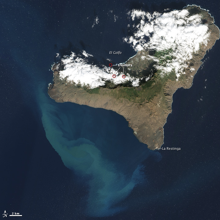
quote:NOTE 400 AVCAN - EARTHQUAKE ACTIVITY-VOLCANIC - HIERRO ISLAND - DECEMBER 27 2011-10:30 h peninsular - seismic-volcanic activity continues to moderate-low, without seismicity localized, but with some weaknesses detected event (1:13 and 3:28 a.m.) . Continue an important sign of volcanic tremor in the Restinga area, with an amplitude that is on the rise since yesterday at 19:00 h (40%) since the last part, with some explosions, possibly hydromagmatic, especially increasing from midnight. No new earthquakes located. Days ago 1. Yesterday 1. Now go 0. A total of 11,947 earthquakes are located in El Hierro by IGN from 9:00 am of July 19, 2011.
In the spectrogram can clearly see the earthquake of 3:28 pm

[ Bericht 5% gewijzigd door bwt op 27-12-2011 12:23:14 ]
<a href="http://goo.gl/q8fhTe" target="_blank">FAQ?</a>
<a href="http://goo.gl/gYvZFq" target="_blank">Geel is een zonnige en vrolijke kleur, als hij tenminste enigszins warm is gekleurd en wat naar het oranje neigt</a>
<a href="http://goo.gl/gYvZFq" target="_blank">Geel is een zonnige en vrolijke kleur, als hij tenminste enigszins warm is gekleurd en wat naar het oranje neigt</a>
quote:


[ Bericht 1% gewijzigd door bwt op 27-12-2011 19:37:09 ]
<a href="http://goo.gl/q8fhTe" target="_blank">FAQ?</a>
<a href="http://goo.gl/gYvZFq" target="_blank">Geel is een zonnige en vrolijke kleur, als hij tenminste enigszins warm is gekleurd en wat naar het oranje neigt</a>
<a href="http://goo.gl/gYvZFq" target="_blank">Geel is een zonnige en vrolijke kleur, als hij tenminste enigszins warm is gekleurd en wat naar het oranje neigt</a>
en een veel zwakkere bevingquote:Earthquake of 6.5 in the middle of the Siberian plate in a place where normal is not very powerful so this seismicity. It shows a teleseismic at all stations on line of the Canary Islands, except the CHIE that shielded by the tremor signal, which continues to rise, now is three times stronger in amplitude than yesterday when it began to climb 19:00 pm o'clock
M 6.5 - SOUTHWESTERN SIBERIA, RUSSIA - 27/12/2011 15:21 UTC
[bron]
1119077 27/12/2011 21:22:13 27.7850 -18.0459 21 1.8 4 NW FRONTERA.IHI

<a href="http://goo.gl/q8fhTe" target="_blank">FAQ?</a>
<a href="http://goo.gl/gYvZFq" target="_blank">Geel is een zonnige en vrolijke kleur, als hij tenminste enigszins warm is gekleurd en wat naar het oranje neigt</a>
<a href="http://goo.gl/gYvZFq" target="_blank">Geel is een zonnige en vrolijke kleur, als hij tenminste enigszins warm is gekleurd en wat naar het oranje neigt</a>
jeeej! We gaan weer verder 
Inorbit: zeg dat dan typluie triangeljosti
Beauregard: Een beetje FOK!ker laat het brood door z'n moeder smeren.
Ecosia
ek's 'n flash drive, jy's 'n floppy
Beauregard: Een beetje FOK!ker laat het brood door z'n moeder smeren.
Ecosia
ek's 'n flash drive, jy's 'n floppy
Echt geen idee wat die vulkaan van plan is
Vreemde pieken zitten er in.
AVCAN heeft het ook over drumbeats.

quote:Update 28/12 – 08:05 UTC
- 1 hour later it looks like we had a vent collapse as the tremor is getting gradually back again
Update 28/12 – 07:05 UTC
- After some really turbulent harmonic tremor in between 05:00 and 06:00, harmonic tremor came almost to a halt. We do think that the eruption subsided a lot the last several days but that the current decrease has to be linked to a vent collapse. If this is the case the harmonic tremor will gradually pick up gain as the magma finds his way out.


quote:NOTE AVCAN 401 - EARTHQUAKE ACTIVITY-VOLCANIC - HIERRO ISLAND - DECEMBER 28 2011-10:30 h peninsular - seismic-volcanic activity continues to moderate, localized seismicity in el Golfo and Mar de las Calmas and some weak events detected. Continued volcanic tremor signal important in Restinga area, still strong until between 5:00 and 6:00 madrugaga has been made to hydromagmatic stronger explosions, 3 or 4, by interaction with water which have had to change the morphology of the outlet duct, or open another mouth, cleared completely, and making it flow smoothly, which has led to the fall of the tremor. After an hour with low tremor, has been again giving small cyclic explosions, the so-called Drumbeats .. these if they are .. with very short bursts at a mean time interval (such as half a minute or so). As for earthquakes, the magnitude was between 1.8 and 0.8. New earthquakes 3. Depth at 9, 12 and 21km. Days ago 1. Yesterday 2. Today they 1. A total of 11,950 earthquakes are located in El Hierro by IGN from 9:00 am of July 19, 2011.

Vreemde pieken zitten er in.
AVCAN heeft het ook over drumbeats.
<a href="http://goo.gl/q8fhTe" target="_blank">FAQ?</a>
<a href="http://goo.gl/gYvZFq" target="_blank">Geel is een zonnige en vrolijke kleur, als hij tenminste enigszins warm is gekleurd en wat naar het oranje neigt</a>
<a href="http://goo.gl/gYvZFq" target="_blank">Geel is een zonnige en vrolijke kleur, als hij tenminste enigszins warm is gekleurd en wat naar het oranje neigt</a>
ik denk, niet gehinderd door enige vorm van kennis, dat het nog wel een poosje gaat duren. De aanloop is zo lang geweest met zoveel opbouw (als je kijkt naar het aantal aardbevingen) dat het me stug lijkt dat het met een paar weken is afgelopen.
Ook wat hier boven staat over een vent collaps klinkt aannemelijk. Maar als er weer lichte ondiepe aardbevingen zijn lijkt het me dat er weer drukopbouw is...
maar ik ben een leek. Dus whatever ;-)
Ik blijf het nog wel even volgen
Ook wat hier boven staat over een vent collaps klinkt aannemelijk. Maar als er weer lichte ondiepe aardbevingen zijn lijkt het me dat er weer drukopbouw is...
maar ik ben een leek. Dus whatever ;-)
Ik blijf het nog wel even volgen
Inorbit: zeg dat dan typluie triangeljosti
Beauregard: Een beetje FOK!ker laat het brood door z'n moeder smeren.
Ecosia
ek's 'n flash drive, jy's 'n floppy
Beauregard: Een beetje FOK!ker laat het brood door z'n moeder smeren.
Ecosia
ek's 'n flash drive, jy's 'n floppy
Gister zijn de tremors zo goed als weg gevallen waardoor verschillende sites melden dat de vulcanische activiteit voorbij was.
Maar na 16:40 is er weer een kleine tremor die langzaam aan aan het groeien is.
[ Bericht 64% gewijzigd door bwt op 29-12-2011 08:27:07 ]
Maar na 16:40 is er weer een kleine tremor die langzaam aan aan het groeien is.

Oftewel - de vulkaan krijgt het steeds moeilijker om z'n lava uit te stoten omdat deze sneller afkoelt dan dat er nieuwe aangevoerd kan worden.quote:A personal opinion: I have the impression that the submarine volcano has released the final raspberry after a long deposition.
What I say of raspberry crackling under final.
And here's a theory that has upset the balance water-magma-pressure gases and it has penetrated the fissure running fast to cause evaporation and the resulting "bloat" as volcanic farts.
The result would be the crystallization of magma near the crack sealing and practice the same, preventing movements "peristaltic" of magma that no longer runs and therefore the tremor.
However, the digestion is not over ... would expect an increase in bowel sounds in the form of seismicity, and who knows ...
Turns out, the specific heat of water is 4 times greater than that of basaltic magma in mass, although the basalt is three times denser than water, the water still has greater cooling capacity comparing volumes. Therefore, it may have been broken as well preventing thermal equilibrium crystallization of basalt. But ... does not mean that the magma continues to have no end pressure ... simply does not flow as before because the water cools more quickly the volume of magma produced than before ...
That pressure, residual, could still have enough force to cause the opening of a crack after an event after shooting? Is it in the salty sea or land would be where the magma cools both the lack of water?
Counter-theory and opinions are welcome, the discussion comes the light.
(JR)
[bron]
[ Bericht 64% gewijzigd door bwt op 29-12-2011 08:27:07 ]
<a href="http://goo.gl/q8fhTe" target="_blank">FAQ?</a>
<a href="http://goo.gl/gYvZFq" target="_blank">Geel is een zonnige en vrolijke kleur, als hij tenminste enigszins warm is gekleurd en wat naar het oranje neigt</a>
<a href="http://goo.gl/gYvZFq" target="_blank">Geel is een zonnige en vrolijke kleur, als hij tenminste enigszins warm is gekleurd en wat naar het oranje neigt</a>
Drukopbouw , BOEM! Happy New Year El Hierro!quote:
Gister zijn de tremors zo goed als weg gevallen waardoor verschillende sites melden dat de vulcanische activiteit voorbij was.
Maar na 16:40 is er weer een kleine tremor die langzaam aan aan het groeien is.
[ afbeelding ]
[..]
Oftewel - de vulkaan krijgt het steeds moeilijker om z'n lava uit te stoten omdat deze sneller afkoelt dan dat er nieuwe aangevoerd kan worden.
Inorbit: zeg dat dan typluie triangeljosti
Beauregard: Een beetje FOK!ker laat het brood door z'n moeder smeren.
Ecosia
ek's 'n flash drive, jy's 'n floppy
Beauregard: Een beetje FOK!ker laat het brood door z'n moeder smeren.
Ecosia
ek's 'n flash drive, jy's 'n floppy
quote:Update 29/12 – 07:50 UTC
- Although we only had minor harmonic tremor all night long, we were very surprised to see a beautiful stain this morning. It can still be seen at this time on the Eruption webcam. At regular times we see a jacuzzi in the middle of the stain and on the same location as the former vent.
- El Hierro experienced a new M 2.3 earthquake at a depth of 18 km at 02:46 earlier today.

1119282 29/12/2011 09:01:13 27.6570 -18.0013 15 1.5 mbLg SW EL PINAR.IHI [+]quote:NOTE AVCAN 402 - EARTHQUAKE ACTIVITY-VOLCANIC - HIERRO ISLAND - DECEMBER 29 2011-9:45 pm peninsular - seismic-volcanic activity continues to moderate, weak seismicity located in the las Calmas sea and some weak events detected. Continued volcanic tremor signal in the Restinga area, after standing today from 10:23 h to 16:37 h, with an amplitude that has been rising since the small phreatomagmatic explosion yesterday at 8:46 after which the tremor almost stops, but was recently restored and is still rising. The magnitude of the earthquake of 2.3 only. New earthquakes 1. 14km depth. Before yesterday 2. Yesterday 3. Today they 1. A total of 11,953 earthquakes are located in El Hierro by IGN from 9:00 am of July 19, 2011.

1119271 29/12/2011 05:01:53 27.6595 -18.0531 14 2.3 mbLg SW EL PINAR.IHI [+]

En voor de webcams - voor wie ze mist:
http://hierroendirecto.movistar.es/
en een timelapsje van vanochend

[ Bericht 20% gewijzigd door bwt op 29-12-2011 11:06:23 ]
<a href="http://goo.gl/q8fhTe" target="_blank">FAQ?</a>
<a href="http://goo.gl/gYvZFq" target="_blank">Geel is een zonnige en vrolijke kleur, als hij tenminste enigszins warm is gekleurd en wat naar het oranje neigt</a>
<a href="http://goo.gl/gYvZFq" target="_blank">Geel is een zonnige en vrolijke kleur, als hij tenminste enigszins warm is gekleurd en wat naar het oranje neigt</a>
En de sensor CHIE lijkt nu echt kapot te zijn. Er worden niet eens tremors geregistreerd. En dat terwijl de jacuzzi er nog wel is.
Er zijn gister zelfs rokende lava stenen gesignaleerd. (earthquake report en AVCAN)

Er zijn gister zelfs rokende lava stenen gesignaleerd. (earthquake report en AVCAN)


<a href="http://goo.gl/q8fhTe" target="_blank">FAQ?</a>
<a href="http://goo.gl/gYvZFq" target="_blank">Geel is een zonnige en vrolijke kleur, als hij tenminste enigszins warm is gekleurd en wat naar het oranje neigt</a>
<a href="http://goo.gl/gYvZFq" target="_blank">Geel is een zonnige en vrolijke kleur, als hij tenminste enigszins warm is gekleurd en wat naar het oranje neigt</a>
Tremors zijn er wel
Maar IGN had kennelijk gister de schaal/verhouding aangepast.
Nu klopt het weer een stuk beter.
Volgens earthquake report zijn er zelfs nog een paar bevingen geweest
[ Bericht 48% gewijzigd door bwt op 30-12-2011 18:49:26 ]
Maar IGN had kennelijk gister de schaal/verhouding aangepast.
Nu klopt het weer een stuk beter.
Volgens earthquake report zijn er zelfs nog een paar bevingen geweest
quote:Update 30/12 15:11 UTC
- A third earthquake occurred only 2 minutes after the second and ONLY 1 km from El Pinar :
1119453 30/12/2011 13:01:32 16 1.1 W EL PINAR.IHI
Update 30/12 13:28 UTC
- Joke sends her regards to all those people who enjoyed her participation to this report for the last couple of months and she also thanks those people sending her a happy birthday yesterday and today.
- 2 new earthquakes occurred with only 32 seconds in between them
2011/12/30 12:59:04.60 Depth 19.60 M 1.80 NW FRONTERA.IHI
2011/12/30 12:59:36.14 Depth 22.70 M 1.10 W FRONTERA.IHI
quote:NOTE AVCAN 403 - EARTHQUAKE ACTIVITY-VOLCANIC - HIERRO ISLAND - DECEMBER 30 2011-10:00 h peninsular - seismic-volcanic activity continues to moderate, weak seismicity located in the sea of calmas, in the Julan and in the dorsal area South Rerstinga above as well as some weak events detected. Continued volcanic tremor signal in the Restinga area, with an amplitude that has been rising since the pop phreatomagmatic of day before yesterday but in the last two hours has started to fall. The magnitude of 1.5 and 1.4. New earthquakes 2. 15 and 16km depth. Before yesterday 3. Yesterday 3. Now go 0. A total of 11,955 earthquakes are located in El Hierro by IGN from 9:00 am of July 19, 2011.
[ Bericht 48% gewijzigd door bwt op 30-12-2011 18:49:26 ]
<a href="http://goo.gl/q8fhTe" target="_blank">FAQ?</a>
<a href="http://goo.gl/gYvZFq" target="_blank">Geel is een zonnige en vrolijke kleur, als hij tenminste enigszins warm is gekleurd en wat naar het oranje neigt</a>
<a href="http://goo.gl/gYvZFq" target="_blank">Geel is een zonnige en vrolijke kleur, als hij tenminste enigszins warm is gekleurd en wat naar het oranje neigt</a>

quote:The tremor in addition to rise and have to watch from time to time some sismito, as of 20:15, now beginning to have more powerful explosions hydromagmatic which was having until now, at 20:27 and 20:45, possibly due to water entering the duct system where they exit the volcanic magma eruption near the Restinga. Would not surprise me that they had been felt, then remember to complete the questionnaire macrosisimico IGN for this purpose ... (Enrique)
[bron]

quote:Magneto ¿quee?
Aerial magnetometry. Is the most overlooked?
Earth's magnetic field is not uniform, moreover, is changing over time. Why? Because "Gaia" or "Gaya" as the ancient Greeks called Mother Earth, appears to be a living being. Moves inside.
The Earth's core, composed mainly by heavy metals, castings, such as iron and nickel (and GOLD! One of the densest metals, but non-magnetic) ... magnetic properties are known. This nucleus seems to work as a dynamo, and its motion generates the field that makes compasses point to magnetic north current location, not the North Pole, but somewhere in northern Canada, a place ... weird strange place, it is constantly changing position over time!
Also consider that the earth is round or flat ... but an ovoid (egg) irregular.
The variations of the magnetic north pole has been such that in the course of geologic time has come even to reverse of form and manner that the magnetic north pole has been placed several times in the Earth's geographic South, thing that happens with some frequency (the frequency measure geologic time). These variations are studied one branch of science called paleomagnetism.
But let's talk about paleomagnetism, but more subtle and small variations of the magnetic field in shorter times (not geological but years), not globally, but very local. Variations so small they are measured in nano-Teslas.
Why are these small variations? Well, for several reasons:
It turns out that the composition of the soil and subsoil, is not uniform, and in the case of volcanic systems is variable magmatic intrusions material. There are rocks, which contain more iron composition, and some less. In some, iron may be more magnetized than other factors such as being subjected to high temperatures during its formation, or ... Even more interesting, for defects that occur when piezoelectric materials tensioned pressures of strata over others. Remind them that the piezoelectric effect it can check the burners without flint, without battery, those in which an electric spark jumps as they hit a piece of mica that has been inside gossip.
And even more interesting is that, much magmatic material contains enough iron magnetic, such as basalt. Thus, the flow of magma generated in the magnetic field variations for the same dynamo effect that we cited earlier.
And how do you measure these changes? The most common method is the use of high-precision magnetometer in combination with GPS installed on airplanes or helicopters in gondolas hanging aerodynamic in flight. An efficient method that allows to cover large areas at a relatively low cost.
Hence the repeated measurement of micromagnetism variations can give us an idea of where you're going or where magma layers are more depressed or even find certain types of plutonic rocks, water, or oil and so on. and so on.
What's more! in both MapIT quasi "paleomagnetic" of the islands, accompanied, and paleomagnetic say because they are made with the results obtained during a 1993 campaign far, there is a curious circumstance: which is that in the Western Isles, and in where the largest magnetic anomalies are these anomalies coincide with areas of more recent volcanic activity:
- In La Palma, Zone and Volcano Teneguía San Antonio
- In central Tenerife Island, near the Chinyero, Pico Viejo.
- And in El Hierro in the area of Julan, Restinga and Sea of Calm!
Yes, gentlemen and gentlemen, a map of 1993 is giving us information about the places most likely to be developed eruptive phenomena, no less!
Hence, it creates, does not seem that you are giving due importance to the observations on the micro-variations of magnetism. Variations, which is not spoken in public by the responsible thing. We do not know, well, if it's because there have been no new observational campaigns aeromagnetic, either because of a lack of specialists in the matter, or by the general policy of "reserve" misinformation and anti-training.
Consequently, the Canary Islands should be candidates for regular flights provide insights into the evolution of the magnetic anomalies, and that, far beyond what is permitted stationary magnetometer stations installed in the archipelago whose measurements shall be reported to either "mob" from the obtuse set of acronyms that we all know, that is, do not realize, to all taxpayers.
But, why?
If no one knows what the magnetometry!
(JR)
[bron]
[meer info over magnetisme van de canarische eilanden (en spanje) (engelse PDF)]
En een spaanse PDF

[ Bericht 46% gewijzigd door bwt op 31-12-2011 10:51:08 ]
<a href="http://goo.gl/q8fhTe" target="_blank">FAQ?</a>
<a href="http://goo.gl/gYvZFq" target="_blank">Geel is een zonnige en vrolijke kleur, als hij tenminste enigszins warm is gekleurd en wat naar het oranje neigt</a>
<a href="http://goo.gl/gYvZFq" target="_blank">Geel is een zonnige en vrolijke kleur, als hij tenminste enigszins warm is gekleurd en wat naar het oranje neigt</a>
quote:NOTE AVCAN 404 - EARTHQUAKE ACTIVITY-VOLCANIC - HIERRO ISLAND - DECEMBER 31, 2011-10:30 h peninsular - seismic-volcanic activity remains moderate, weak seismicity located in the Gulf, and the interior of the island, and some events weakest detected. Continued volcanic tremor signal in the Restinga area, with an amplitude that remains from the last note, though in the last two hours has begun to rise. The magnitude of 1.8 and 0.9. New earthquakes 4. Depth to 12, 16, 20 and 23km. Before yesterday 3. Yesterday 3. Today they 1. A total of 11,959 earthquakes are located in El Hierro by IGN from 9:00 am of July 19, 2011.
<a href="http://goo.gl/q8fhTe" target="_blank">FAQ?</a>
<a href="http://goo.gl/gYvZFq" target="_blank">Geel is een zonnige en vrolijke kleur, als hij tenminste enigszins warm is gekleurd en wat naar het oranje neigt</a>
<a href="http://goo.gl/gYvZFq" target="_blank">Geel is een zonnige en vrolijke kleur, als hij tenminste enigszins warm is gekleurd en wat naar het oranje neigt</a>
quote:Update 31/12 – 11:07 UTC
- The Restingolitas, as the Smoking Lava Stones are called in El Hierro, are coming up at regular intervals. As our 2 good webcams are having server problems (also the Frontera webcams are down), we have to stay with the U-stream El Pinar webcam. He has a fairly good zoom, but as this is a fixed camera, he shoots almost always to the side of the SLS. The stones can be seen on the wide angle though. Keep looking.
<a href="http://goo.gl/q8fhTe" target="_blank">FAQ?</a>
<a href="http://goo.gl/gYvZFq" target="_blank">Geel is een zonnige en vrolijke kleur, als hij tenminste enigszins warm is gekleurd en wat naar het oranje neigt</a>
<a href="http://goo.gl/gYvZFq" target="_blank">Geel is een zonnige en vrolijke kleur, als hij tenminste enigszins warm is gekleurd en wat naar het oranje neigt</a>
Nieuw leven in de brouwerij?
quote:NOTE AVCAN 405 - EARTHQUAKE ACTIVITY-VOLCANIC - HIERRO ISLAND - 01 January 2012-11:00 h peninsular - seismic-volcanic activity continues to moderate, moderate seismicity located in the Gulf and weak in the interior of the island, and some events weakest detected. Continued volcanic tremor signal in the Restinga area, with an amplitude that has decreased since the last tonight note, although in the last hours has begun to rise again. Yesterday saw the smoldering pyroclastic yesterday. The magnitude of 2.5 and 0.3. New quakes 8. Depth between 14 and 16 km (And one to 13 and another at 23km). Before yesterday 3. Yesterday 2. Now go 7. A total of 11,967 earthquakes are located in El Hierro by IGN from 9:00 am of July 19, 2011.
----------------------
THE VOLCANO OF El Hierro continues to emit magmatic material.
31/12/2011 ... 16:44 - Ministry of Economy, Finance and Security
Scientists aboard a boat Salvamar, last Friday could see large pyroclastic
The volcano of El Hierro continues to emit large steaming magmatic material, as they could check on the morning of Friday, scientists from the National Geographic Institute (IGN) from a boat Salvamar Maritime Rescue.
Since Thursday the issue was intensified in the header area where bubbling was observed and fine material. In addition, the green part was very definite throughout the day.
The report of the mission SASEMAR 103, notes the observation of three very small emission areas and the corresponding material derived from the south due to sea conditions and prevailing winds. Emission points in the water temperature was 17.5 ° C, while the nearest clean water temperature was 19.6 ° C.
Behavior of the tremor signal
During the day yesterday, Friday 30 December, the tremor signal recorded by the seismic monitoring network throughout the morning kept the same level reached the previous day. However, slightly increased its amplitude at 09:30 hours, coinciding with the emission of lava fragments on the surface and was also observed to a pulse energy throughout the day. This level was maintained for the day with slight fluctuations.
On Thursday, the tremor signal recorded by the seismic monitoring network maintained the level achieved the previous day, detecting some small pulses of short duration and slight fluctuations.
Although the signal has a low amplitude tremor is present in the record confirming continuity of the eruption.
Moreover, in terms of seismic activity located in El Hierro, Thursday and Friday, IGN posted a total of 6 events of low magnitude, although none of them was felt by the population. On Friday three movements were detected at a depth of between 16 and 20 miles, two of which were located in the area of the Gulf, one sea and one on land, and the third also on land west of the town of El Pinar .
On Thursday, three events were recorded at a depth of between 14 and 16 miles, two of them located in the El Julan, of magnitudes 1.4 and 1.5, and another near La Restinga which reached 2.3 degrees of magnitude.
In total since July 19, 11 949 events have been found.
Deformation
Stations showed deformation control stations yesterday in the Gulf is a slight tendency towards the north in the horizontal components. In the rest of the island and in the vertical components showed a stable pattern.

quote:Update 01/01 – 10:19 UTC
- The start of the year has not been missed by the volcano. A swarm of 7 earthquakes will probably give new strenth to the eruption. The number of earthquakes is the biggest during a limited time frame since many weeks.
- Harmonic tremor is still limited, which may be the cause of the many earthquakes
- Telefonica and Movistar will have some days off – The server problem is not yet solved (all 4 webcams do not work). We remind our readers that Movistar / Telefonica is one of the most important telecommunications companies of the world !?! We really liked what they did so far, but this can be handled better.
- The good old fixed U-stream webcam is the only one who also works on New Years day and he shows a lot of activity this morning. Big stain and a wide stirring area.


<a href="http://goo.gl/q8fhTe" target="_blank">FAQ?</a>
<a href="http://goo.gl/gYvZFq" target="_blank">Geel is een zonnige en vrolijke kleur, als hij tenminste enigszins warm is gekleurd en wat naar het oranje neigt</a>
<a href="http://goo.gl/gYvZFq" target="_blank">Geel is een zonnige en vrolijke kleur, als hij tenminste enigszins warm is gekleurd en wat naar het oranje neigt</a>
Vandaag lijkt rustig

quote:Update 02/01 – 13:38 UTC
- Joke made her daily morning walk and took a lot of beautiful pictures. The stain and the brownish center can well be distinguished on the images. Click on one of the thumbnails to watch the entire series.
- While making her walk she had a talk with the Cabildo / Telefonica maintenance webcam technician. When Joke asked him what was going on he was very surprised (means that he isn’t looking at the images himself) and he said that his webcam was working perfectly. He then continued saying that “it must certainly a Madrid servidor issue”. We are almost certain that in Madrid NOBODY knows what is going on.
quote:NOTE AVCAN 406 - EARTHQUAKE ACTIVITY-VOLCANIC - HIERRO ISLAND - 02 January 2012-11:00 h peninsular - seismic-volcanic activity remains moderate with moderate seismicity located today in sea of las Calmas and yesterday in the interior of the island and the North as well as some weak events detected. Continued volcanic tremor signal in the Restinga area, with an amplitude that after growing up at 2 in the morning, then has halved in the last hours and has started to rise again. Yesterday saw the smoldering pyroclastic first thing and then there was a stain brown and bubbling. The magnitude of 1.8 and 1.1. New earthquakes 4. Depth to 10, 17, 22 and 34 km. Before yesterday 2. Yesterday 9. Today van 2. A total of 11,963 earthquakes are located in El Hierro by IGN from 9:00 am of July 19, 2011.
<a href="http://goo.gl/q8fhTe" target="_blank">FAQ?</a>
<a href="http://goo.gl/gYvZFq" target="_blank">Geel is een zonnige en vrolijke kleur, als hij tenminste enigszins warm is gekleurd en wat naar het oranje neigt</a>
<a href="http://goo.gl/gYvZFq" target="_blank">Geel is een zonnige en vrolijke kleur, als hij tenminste enigszins warm is gekleurd en wat naar het oranje neigt</a>
Sinds gister zijn de tremors weer sterk omlaag gegaan.
Vandaag lijkt het weer een ietsie pietsie omhoog te gaan.
Vandaag lijkt het weer een ietsie pietsie omhoog te gaan.

<a href="http://goo.gl/q8fhTe" target="_blank">FAQ?</a>
<a href="http://goo.gl/gYvZFq" target="_blank">Geel is een zonnige en vrolijke kleur, als hij tenminste enigszins warm is gekleurd en wat naar het oranje neigt</a>
<a href="http://goo.gl/gYvZFq" target="_blank">Geel is een zonnige en vrolijke kleur, als hij tenminste enigszins warm is gekleurd en wat naar het oranje neigt</a>
Zo Terug van vakantie. Een hoop gebeurd zie ik.
Momenteel SLS! te zien op de USTRAM
http://earthquake-report.com/2011/11/12/32535/
Momenteel SLS! te zien op de USTRAM
http://earthquake-report.com/2011/11/12/32535/


<a href="http://goo.gl/q8fhTe" target="_blank">FAQ?</a>
<a href="http://goo.gl/gYvZFq" target="_blank">Geel is een zonnige en vrolijke kleur, als hij tenminste enigszins warm is gekleurd en wat naar het oranje neigt</a>
<a href="http://goo.gl/gYvZFq" target="_blank">Geel is een zonnige en vrolijke kleur, als hij tenminste enigszins warm is gekleurd en wat naar het oranje neigt</a>
Had ik er al iets eerder neergezetquote:
Weer een wat groei in de tremors.
[ afbeelding ]
<a href="http://goo.gl/q8fhTe" target="_blank">FAQ?</a>
<a href="http://goo.gl/gYvZFq" target="_blank">Geel is een zonnige en vrolijke kleur, als hij tenminste enigszins warm is gekleurd en wat naar het oranje neigt</a>
<a href="http://goo.gl/gYvZFq" target="_blank">Geel is een zonnige en vrolijke kleur, als hij tenminste enigszins warm is gekleurd en wat naar het oranje neigt</a>
quote:Curiously, at least, that tremor reduction at low frequencies, the system, increase the noise in the higher frequencies as the graph CHIE PSD spectrogram. This may indicate that although magma output one can be sealed, the exhaust has increased. (JR)

<a href="http://goo.gl/q8fhTe" target="_blank">FAQ?</a>
<a href="http://goo.gl/gYvZFq" target="_blank">Geel is een zonnige en vrolijke kleur, als hij tenminste enigszins warm is gekleurd en wat naar het oranje neigt</a>
<a href="http://goo.gl/gYvZFq" target="_blank">Geel is een zonnige en vrolijke kleur, als hij tenminste enigszins warm is gekleurd en wat naar het oranje neigt</a>

quote:Update 03/01 – 09:18 UTC
- The video below has been recorded a few days ago by Carmen Lopez (IGN) and the Salvamar Adhara crew. This is also the video Joke Volta has been watching at the CAP science center in La Restinga. It was taped with the underwater camera (not a ROV) connected to a cable. What you can see is gas emissions and a lot of jellyfish. Nobody knows what the jellyfish are doing there, they seem to be attracted by the specific water composition and/or higher temperature. At the end the camera arrives in a very interesting environment with much more activity and then it suddenly stops. The video was published on the Canary Islands President site.
quote:New post for comments WEBCAMS. currently only works Pinar webcam or ACNpress Ayto and slick looks perfect .. sometimes greenish-brown, bubbling area at times and pyroclastic floating about smoking, are from time to time .. while writing this, I've seen a couple of them, especially the white smoke ... ^ _-(Enrique).
quote:NOTE AVCAN 407 - EARTHQUAKE ACTIVITY-VOLCANIC - HIERRO ISLAND - 03 January 2012-10:15 h peninsular - seismic-volcanic activity remains moderate with moderate seismicity located on the ground today, close to the Restinga, east, and some weakest events detected.
Continued volcanic tremor signal in the Restinga area, with an amplitude that was down yesterday, then rallied from 20:00 h and doubled and that from midnight yesterday remains more or less stable, with downward and a small signal gain at all frequencies at about 6:23 pm Today, like yesterday besides the bubbling brown spot and pyroclastics are floating in the steaming webcams.
The magnitude of 2.0. New 1 + 1 revised earthquake yesterday. Depth to 16 km. The day before yesterday 10. Yesterday 2. Today they 1. A total of 11,965 earthquakes are located in El Hierro by IGN from 9:00 am of July 19, 2011.
<a href="http://goo.gl/q8fhTe" target="_blank">FAQ?</a>
<a href="http://goo.gl/gYvZFq" target="_blank">Geel is een zonnige en vrolijke kleur, als hij tenminste enigszins warm is gekleurd en wat naar het oranje neigt</a>
<a href="http://goo.gl/gYvZFq" target="_blank">Geel is een zonnige en vrolijke kleur, als hij tenminste enigszins warm is gekleurd en wat naar het oranje neigt</a>
Voor wie het nog niet ontdekt heeft...
De andere 2 webcams zijn via deze link wel te bekijken.
http://hierroendirecto.movistar.es/
De andere 2 webcams zijn via deze link wel te bekijken.
http://hierroendirecto.movistar.es/

Net als gister lijkt het aan het golven met een frequentie van 12 uur (check maar bij die van gister)
<a href="http://goo.gl/q8fhTe" target="_blank">FAQ?</a>
<a href="http://goo.gl/gYvZFq" target="_blank">Geel is een zonnige en vrolijke kleur, als hij tenminste enigszins warm is gekleurd en wat naar het oranje neigt</a>
<a href="http://goo.gl/gYvZFq" target="_blank">Geel is een zonnige en vrolijke kleur, als hij tenminste enigszins warm is gekleurd en wat naar het oranje neigt</a>
Invulcan helivlucht van eergister. (2 jan)
en de berichtgeving van gister:


en de berichtgeving van gister:
quote:THE EXTENT OF THE TREMOR OF EL HIERRO eruptive process is almost constant.
03/01/2012 ... 15:37 - Ministry of Economy, Finance and Security
The tremor signal recorded by the seismic monitoring network of the National Geographic Institute (IGN) has remained almost constant during the second day of January, as reported by that body to the direction of the Civil Protection Plan for Volcanic Risk ( PEVOLCA).
Specifically, the signal continued until 3:00 am then a constant amplitude amplitude decline sharply, beginning a slight gradual increase until it stabilizes at 6:00 for ten hours. After this period and within a low level of tremor, the signal began recording a slight decrease in amplitude for four hours, recovering the level of middle of the day. Although the signal has a low amplitude tremor is present in the record confirming that the eruptive process continues.
Regarding the seismicity should be noted that, during the day yesterday, is located two low-magnitude events in the area of the Julan, around three in the morning, which were not felt by the population .. In total, since the day July 19, 2011 11 959 events have been found.
Deformation
The deformation monitoring stations throughout the island show a stable pattern in the vertical component and the horizontal. At stations located south vertical is a trend of deflation.
Spot
For its part, the stain was visible throughout the day with a well-defined bubble and fine material. The green part widely spread eastward from the broadcast center, by the action of ocean currents. The day before, on January 1, the emission area was well defined with a brown center and in the morning there were moments of matter emissions. During the rest of the day was observed bubbling bad that sometimes even produced bubble rings
<a href="http://goo.gl/q8fhTe" target="_blank">FAQ?</a>
<a href="http://goo.gl/gYvZFq" target="_blank">Geel is een zonnige en vrolijke kleur, als hij tenminste enigszins warm is gekleurd en wat naar het oranje neigt</a>
<a href="http://goo.gl/gYvZFq" target="_blank">Geel is een zonnige en vrolijke kleur, als hij tenminste enigszins warm is gekleurd en wat naar het oranje neigt</a>
quote:NOTE AVCAN 408 - EARTHQUAKE ACTIVITY-VOLCANIC - HIERRO ISLAND - 04 January 2012-10:45 h peninsular - seismic-volcanic activity remains moderate with moderate seismicity located in the north today, in the sea of el Golfo, and some events weakest detected. Continued volcanic tremor signal in the eruption of the Restinga, with an amplitude that remains more or less stable. Today, like yesterday besides the bubbling brown spot and pyroclastics are floating in the steaming webcams. The magnitude of 1.4. New earthquakes 1. Depth to 16.7 km. Before yesterday 2. Yesterday 1. Today they 1. A total of 11,966 earthquakes are located in El Hierro by IGN from 9:00 am of July 19, 2011.

[ Bericht 10% gewijzigd door bwt op 04-01-2012 11:16:19 ]
<a href="http://goo.gl/q8fhTe" target="_blank">FAQ?</a>
<a href="http://goo.gl/gYvZFq" target="_blank">Geel is een zonnige en vrolijke kleur, als hij tenminste enigszins warm is gekleurd en wat naar het oranje neigt</a>
<a href="http://goo.gl/gYvZFq" target="_blank">Geel is een zonnige en vrolijke kleur, als hij tenminste enigszins warm is gekleurd en wat naar het oranje neigt</a>

quote:Update 04/01 – 10:49 UTC
- A lot of SLS / smoking pumice this morning.
- Salvamar Adhara is out to pick up material or even to try videotaping what happens (if they are ready to risk their material).
<a href="http://goo.gl/q8fhTe" target="_blank">FAQ?</a>
<a href="http://goo.gl/gYvZFq" target="_blank">Geel is een zonnige en vrolijke kleur, als hij tenminste enigszins warm is gekleurd en wat naar het oranje neigt</a>
<a href="http://goo.gl/gYvZFq" target="_blank">Geel is een zonnige en vrolijke kleur, als hij tenminste enigszins warm is gekleurd en wat naar het oranje neigt</a>
ben benieuwd wanneer het nieuwe eiland geboren gaat worden
Inorbit: zeg dat dan typluie triangeljosti
Beauregard: Een beetje FOK!ker laat het brood door z'n moeder smeren.
Ecosia
ek's 'n flash drive, jy's 'n floppy
Beauregard: Een beetje FOK!ker laat het brood door z'n moeder smeren.
Ecosia
ek's 'n flash drive, jy's 'n floppy
Kans is dat dit best lang kan duren.quote:
ben benieuwd wanneer het nieuwe eiland geboren gaat worden
Als het door blijft stromen zoals de laatste tijd dan kan het nog wel een jaartje duren.
en een video met de timelapse van vanochtend - earthquake report

<a href="http://goo.gl/q8fhTe" target="_blank">FAQ?</a>
<a href="http://goo.gl/gYvZFq" target="_blank">Geel is een zonnige en vrolijke kleur, als hij tenminste enigszins warm is gekleurd en wat naar het oranje neigt</a>
<a href="http://goo.gl/gYvZFq" target="_blank">Geel is een zonnige en vrolijke kleur, als hij tenminste enigszins warm is gekleurd en wat naar het oranje neigt</a>
die tijd heb ik wel ;-)quote:
[..]
Kans is dat dit best lang kan duren.
Als het door blijft stromen zoals de laatste tijd dan kan het nog wel een jaartje duren.
en een video met de timelapse van vanochtend - earthquake report
Inorbit: zeg dat dan typluie triangeljosti
Beauregard: Een beetje FOK!ker laat het brood door z'n moeder smeren.
Ecosia
ek's 'n flash drive, jy's 'n floppy
Beauregard: Een beetje FOK!ker laat het brood door z'n moeder smeren.
Ecosia
ek's 'n flash drive, jy's 'n floppy
Onderstaande video's kunnen dus gebeuren als de vulkaan bovenwater komt.
Zoals in de rode zee is gebeurd in december. (En nog steeds gaande is)
ؚرÙا٠اÙØšØر اÙØ٠ر (2).Ùارؚ٠رØ٠تÙ.تصÙÙر Øصر٠ÙسÙÙÙØ© ÙÙؚع
[ Bericht 5% gewijzigd door bwt op 04-01-2012 15:08:28 ]
Zoals in de rode zee is gebeurd in december. (En nog steeds gaande is)
en commentaar daarop:quote:These days ago they got some pictures of a new island that has emerged from the sea by volcanic activity in the archipelago of Zubair Island in the Red Sea, this video is part of that activity.
These images can help us imagine what might happen in El Hierro .... La Restinga is more or less the same distance from the emission point of the islet on which passes behind the eruption column and all the ash falling .... on second thought, do not pass ... (Enrique)
quote:The thing is that this new island in the Red Sea took months without showing seismicity or anything ... and out of the blue on December 19 began to see the plume and emerge from water in a fairly surtseyana apparently .....


ؚرÙا٠اÙØšØر اÙØ٠ر (2).Ùارؚ٠رØ٠تÙ.تصÙÙر Øصر٠ÙسÙÙÙØ© ÙÙؚع
[ Bericht 5% gewijzigd door bwt op 04-01-2012 15:08:28 ]
<a href="http://goo.gl/q8fhTe" target="_blank">FAQ?</a>
<a href="http://goo.gl/gYvZFq" target="_blank">Geel is een zonnige en vrolijke kleur, als hij tenminste enigszins warm is gekleurd en wat naar het oranje neigt</a>
<a href="http://goo.gl/gYvZFq" target="_blank">Geel is een zonnige en vrolijke kleur, als hij tenminste enigszins warm is gekleurd en wat naar het oranje neigt</a>
Nadat gister middag/avond de tremors sterker waren geworden zijn er dus gloeiende lavastenen gespot in de nachtelijke uren.quote:Update 04/01 – 22:22 UTC
There we go again and take the information as it is – we are not responsible when it should be a boat : )
- Reader Hein commented in our comments section below that he has seen at irregular intervals glowing ashes on the (still zoomed) eruption webcam. After our boat lights history we were far from eager to put this information online, but after looking at the webcam ourselves, we saw the same short-lived incandescent light at various locations . AVCAN members are also sure ! It is smoking lava !
Joke is currently out with her binoculars to look to the sea. She has not seen the glowing lava pieces yet but, sitting on some lava field outside La Restinga, she sees the stain clearly in the moonlight.
This is what can be seen now on then on the eruption webcam (we have captured 2 of the pictures ourselves in about 10 minutes time):


Maar na middernacht zijn de tremors weer geheel ingestort.

1120123 05/01/2012 00:02:39 27.6682 -18.0335 13 1.8 4 SW EL PINAR.IHI

<a href="http://goo.gl/q8fhTe" target="_blank">FAQ?</a>
<a href="http://goo.gl/gYvZFq" target="_blank">Geel is een zonnige en vrolijke kleur, als hij tenminste enigszins warm is gekleurd en wat naar het oranje neigt</a>
<a href="http://goo.gl/gYvZFq" target="_blank">Geel is een zonnige en vrolijke kleur, als hij tenminste enigszins warm is gekleurd en wat naar het oranje neigt</a>
En plaatjes van het lava vissen gister:quote:NOTE AVCAN 409 - EARTHQUAKE ACTIVITY-VOLCANIC - HIERRO ISLAND - 05 January 2012-09:45 h peninsular - seismic-volcanic activity remains moderate with moderate seismicity located in the north today, in the sea of El Golfo, and some events weakest detected. Continued volcanic tremor signal in the eruption of the Restinga, with an amplitude that is held in a spherical pulses 12h 30 min up and down in intensity, doubling the maximum amplitude from the lows. All day yesterday and last night were steaming pyroclastic floating in webcams. The magnitude of 1.8. New earthquakes 1. Depth to 13 km. Days ago 1. Yesterday 1. Today they 1. A total of 11,967 earthquakes are located in El Hierro by IGN from 9:00 am of July 19, 2011.
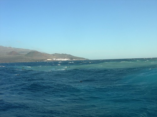
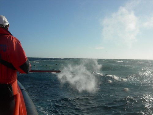
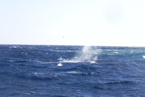
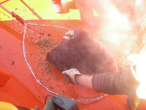
<a href="http://goo.gl/q8fhTe" target="_blank">FAQ?</a>
<a href="http://goo.gl/gYvZFq" target="_blank">Geel is een zonnige en vrolijke kleur, als hij tenminste enigszins warm is gekleurd en wat naar het oranje neigt</a>
<a href="http://goo.gl/gYvZFq" target="_blank">Geel is een zonnige en vrolijke kleur, als hij tenminste enigszins warm is gekleurd en wat naar het oranje neigt</a>
naast de el Hierro bevingen zijn er vandaag ook een X aantal bevingen geweest links en rechts van Tenerife

<a href="http://goo.gl/q8fhTe" target="_blank">FAQ?</a>
<a href="http://goo.gl/gYvZFq" target="_blank">Geel is een zonnige en vrolijke kleur, als hij tenminste enigszins warm is gekleurd en wat naar het oranje neigt</a>
<a href="http://goo.gl/gYvZFq" target="_blank">Geel is een zonnige en vrolijke kleur, als hij tenminste enigszins warm is gekleurd en wat naar het oranje neigt</a>
nice, het is gewoon een hotspot die omhoog komt!quote:
naast de el Hierro bevingen zijn er vandaag ook een X aantal bevingen geweest links en rechts van Tenerife
[ afbeelding ]
;-)
Inorbit: zeg dat dan typluie triangeljosti
Beauregard: Een beetje FOK!ker laat het brood door z'n moeder smeren.
Ecosia
ek's 'n flash drive, jy's 'n floppy
Beauregard: Een beetje FOK!ker laat het brood door z'n moeder smeren.
Ecosia
ek's 'n flash drive, jy's 'n floppy
quote:And are today, January 5, five sismitos around Tenerife, one of Puerto NW, about 11 km from the coast, and the other 4 SE of Candelaria, in a straight line, the farthest about 12 '5 km and the closest to a 4,5 km from the coast, in between the other two, closer, about 6km, and very close together. The size of each map. (Humberto)

quote:Update 05/01 15:22 UTC
- A very curious pattern in GPS deformation patterns (the data which are published are probably 2 days old). The deformation at HI02, HI03 and HI04 climbed strongly ! La Palma deformation stayed approx. the same, but Tenerife and La Gomera GPS data decreased the strongest since the beginning of El Hierro activity. The current earthquakes at Tenerife may have an origin in this strong deflation (tension). The smoking lava Yesterday and Today also. @ IGN to solve the clue here. Hopefully they will explain in their report later today.
quote:There seems to be moving in the Border GPS station in the last two days, in every season reflects a movement that has similar characteristics and should be monitored to see if it continues the next day.
Comparing the data of IGN compared to other stations of Frontera, it's like Frontera station was moving to the east, as there is no relative motion with respect to NS Palma and a movement of approach compared to the Tenerife. HI02, HI03 and HI04 seem to have the same pattern of separation.
As for the vertical deformation .... will have to wait to see part of IGN happens, but if some do not move and goes to the East border, depart hence, it is conceivable that there should be an inflation (Enrique) .
[bron]
[ Bericht 25% gewijzigd door bwt op 05-01-2012 17:30:53 ]
<a href="http://goo.gl/q8fhTe" target="_blank">FAQ?</a>
<a href="http://goo.gl/gYvZFq" target="_blank">Geel is een zonnige en vrolijke kleur, als hij tenminste enigszins warm is gekleurd en wat naar het oranje neigt</a>
<a href="http://goo.gl/gYvZFq" target="_blank">Geel is een zonnige en vrolijke kleur, als hij tenminste enigszins warm is gekleurd en wat naar het oranje neigt</a>
quote:Update 05/01 16:02 UTC
- The glowing lava that we were able to see during the night is probably caused by brittle lava blocks who are breaking apart. IGN did measure the temperatures the last couple of days of the lava blocks while they were picked up out of the sea. The lava blocks which we can see are hollow inside and are containing a lot of gas. This gas is the main reason that they are floating to the surface waters. At the outside the blocks were no warmer than 40°C but the gases at the inside were 200°C. A theory for the flames we saw last night (it was no glowing but ignited gas - see video Julio) is that the hot gas (hard to say which composition) is ignited just by the oxygen when the brittle lava is breaking apart or that the gas is ignited by the high temperature of the lava at the inside.
Once the gas is burned, the lava sinks back to the sea floor.
<a href="http://goo.gl/q8fhTe" target="_blank">FAQ?</a>
<a href="http://goo.gl/gYvZFq" target="_blank">Geel is een zonnige en vrolijke kleur, als hij tenminste enigszins warm is gekleurd en wat naar het oranje neigt</a>
<a href="http://goo.gl/gYvZFq" target="_blank">Geel is een zonnige en vrolijke kleur, als hij tenminste enigszins warm is gekleurd en wat naar het oranje neigt</a>
AVCAN Video van gister
En de 38 bijbehorende foto's
Hier kan je mooi zien dat die lavasteen midden in zo'n bel ligt net aan de oppervlakte komt
En de tremors van vandaag zitten weer op een iets hoger niveau. Maar ja, het golft van hooger naar lager.
[ Bericht 28% gewijzigd door bwt op 06-01-2012 09:08:32 ]


En de 38 bijbehorende foto's


Hier kan je mooi zien dat die lavasteen midden in zo'n bel ligt net aan de oppervlakte komt


En de tremors van vandaag zitten weer op een iets hoger niveau. Maar ja, het golft van hooger naar lager.

[ Bericht 28% gewijzigd door bwt op 06-01-2012 09:08:32 ]
<a href="http://goo.gl/q8fhTe" target="_blank">FAQ?</a>
<a href="http://goo.gl/gYvZFq" target="_blank">Geel is een zonnige en vrolijke kleur, als hij tenminste enigszins warm is gekleurd en wat naar het oranje neigt</a>
<a href="http://goo.gl/gYvZFq" target="_blank">Geel is een zonnige en vrolijke kleur, als hij tenminste enigszins warm is gekleurd en wat naar het oranje neigt</a>
En een beving bij Lanzarote heeft vast te maken met de recente GPS data.
1120245 05/01/2012 17:05:58 29.1047 -14.2260 11 Sentido 3.5 4 ATLÁNTICO-CANARIAS
[ Bericht 4% gewijzigd door bwt op 06-01-2012 09:21:02 ]
1120245 05/01/2012 17:05:58 29.1047 -14.2260 11 Sentido 3.5 4 ATLÁNTICO-CANARIAS

[ Bericht 4% gewijzigd door bwt op 06-01-2012 09:21:02 ]
<a href="http://goo.gl/q8fhTe" target="_blank">FAQ?</a>
<a href="http://goo.gl/gYvZFq" target="_blank">Geel is een zonnige en vrolijke kleur, als hij tenminste enigszins warm is gekleurd en wat naar het oranje neigt</a>
<a href="http://goo.gl/gYvZFq" target="_blank">Geel is een zonnige en vrolijke kleur, als hij tenminste enigszins warm is gekleurd en wat naar het oranje neigt</a>
elhierro webcam laat de hele dag ook mooie rookpluimen zien.
[ Bericht 17% gewijzigd door bwt op 06-01-2012 18:28:30 ]

quote:NOTE AVCAN 410 - EARTHQUAKE ACTIVITY-VOLCANIC - HIERRO ISLAND - 06 January 2012-09:45 h peninsular - seismic-volcanic activity remains moderate with moderate seismicity located in the north today, in the sea of el Golfo, and some events weakest detected. Continued volcanic tremor signal in the eruption of the Restinga, with an amplitude that is held in a spherical pulses 12h 30 min up and down in intensity, doubling the maximum amplitude from the lows. Is rising from the peak intensity yesterday. They are also possibly hydromagmatic small explosion. Yesterday during the day and this morning sporadically mainly pyroclastics are floating in the steaming webcams. Days ago 1. Yesterday 1. Now go 0. A total of 11,967 earthquakes are located in the vicinity of the Iron and IGN from 9:00 am of July 19, 2011.
Update 06/01 14:23 UTC
- Some people are asking us, what would be the next step to look for before it gets really Surtseyan ?
If steam jets are starting to appear (even at limited height of a few meters), this would mean that the lava generated superheated steam reaches the surface waters. From that moment, everything is possible. If the volcano activity gets weaker again, the jets will fall back. It the vent continues to grow with the same activity, the superheated steam will soon carry ash and will become blackened.
- We do not expect this to happen soon, as we expect the current smoking material to be floaters. IGN will certainly inform us in time.
- Based on earlier interviews in the local press, we think that the current philosophy is : no gas alert and / or no earthquakes and / or no strong harmonic tremor = no (potentially dangerous) eruption action
- Good to know is that : IGN people do not really talk to the press about the alert situation, only Pevolca is in charge for press reports
Update 06/01 13:55 UTC
- Thanks to Julio del Castillo Vivero and the ACN Press people, the U-stream webcam is back online.
- NOBODY seems to bother about what is going on at the vent.
- Its Three Kings Day, a festival day in Spain, that maybe the real reason about what is happening.
- We are wandering if people at La Restinga feel OK with what is happening (in the meantime, Joke told me that people at La Restinga are telling her that there is a lot of activity today).
- No helicopters, no boats. No infrared cameras at night.
- Joke went to the CAP science center a little while ago and the IGN people on duty said As usual, nothing special.
- IGN People at CAP were laughing about the burning lava at sea the day before yesterday (thousands of people have seen this phenomenon, images are online, videos are online, what else do they need to be convinced that gas was ignited + Joke has confirmed the burning lava with her binoculars ).
This site is not a science fiction site, but a factual site.
[ Bericht 17% gewijzigd door bwt op 06-01-2012 18:28:30 ]
<a href="http://goo.gl/q8fhTe" target="_blank">FAQ?</a>
<a href="http://goo.gl/gYvZFq" target="_blank">Geel is een zonnige en vrolijke kleur, als hij tenminste enigszins warm is gekleurd en wat naar het oranje neigt</a>
<a href="http://goo.gl/gYvZFq" target="_blank">Geel is een zonnige en vrolijke kleur, als hij tenminste enigszins warm is gekleurd en wat naar het oranje neigt</a>
Het eerste deel van enrique (schuin gedrukt) kon ik niet veel van maken - met google translate
De hele dag/middag is er rook te zien geweest. Of dit komt van 1 of 2 vaste plaatsen of van SLS (smoking lava stones) (Earthquake report roept ook van alles) is niet echt duidelijk. Ook niet na dit verhaal van AVCAN.
En de timelapse van vandaag.
[ Bericht 8% gewijzigd door bwt op 06-01-2012 22:09:16 ]
Die laatste zin lijkt mij niet helemaal te kloppen.....quote:New part of of the Canary Islands, the most notable, if not as bad .. is that the end of the hand say that yesterday was apreciarion lava fragments on the surface, or rather did not see them, all we saw in the last days Webcams and there are in INVOLCAN pictures and videos ... milk to see if you look a little to make the parts and put more care .. (Enrique)
THE EL HIERRO VOLCANO CONTINUES TO CAST magmatic material to the surface.
06/01/2012 ... 15:09 - Ministry of Economy, Finance and Security
This morning large amount of pyroclastic was visible from the coast
The submarine El Hierro volcano continues to cast magmatic material to the surface of the Calmas Sea. This morning, scientists at the National Geographic Institute (IGN) have confirmed the direction of the Civil Protection Plan for Volcanic Risk (PEVOLCA), which from the coast were numerous fragments of lava significant, confirming the continuous activity of the volcano.
In the coming days members of the IGN, with the collaboration of Salvage, try to collect some samples to be analyzed for further study of this eruption will soon be three months of activity.
January 5
During the day yesterday, January 5, the tremor signal recorded by the seismic monitoring network of IGN had a weak decrease reaching a minimum value about 2.30am, which lasted until 4:30 hours. At this time began a gradual increase until at 8:00 recovered the value of the start of the day, keeping practically during the remaining hours.
The seismicity is negligible and only located at 00:02 hours, a movement in the Sea of Calmas, at magnitude 1.8 on the Richter scale and a depth of 13 kilometers, which was not felt by the population.
In total, since the day July 19, 2011 11 962 events have been found.
deformation
The deformation monitoring stations generally show a pattern of stability in the horizontal and vertical components. At the stations of El Golfo there is a slight shift to the south and the area south of the island, a vertical trend of deflation.
spot
In the early hours of the day was very visible colored header with a bubbling central area surrounded by a large area of brown for the content of fine material in suspension. There were no surface lava fragments. Due to the wind and sea conditions during the rest of the day appreciated the anomalous zone.
De hele dag/middag is er rook te zien geweest. Of dit komt van 1 of 2 vaste plaatsen of van SLS (smoking lava stones) (Earthquake report roept ook van alles) is niet echt duidelijk. Ook niet na dit verhaal van AVCAN.
En de timelapse van vandaag.

[ Bericht 8% gewijzigd door bwt op 06-01-2012 22:09:16 ]
<a href="http://goo.gl/q8fhTe" target="_blank">FAQ?</a>
<a href="http://goo.gl/gYvZFq" target="_blank">Geel is een zonnige en vrolijke kleur, als hij tenminste enigszins warm is gekleurd en wat naar het oranje neigt</a>
<a href="http://goo.gl/gYvZFq" target="_blank">Geel is een zonnige en vrolijke kleur, als hij tenminste enigszins warm is gekleurd en wat naar het oranje neigt</a>
Ook deze ochtend veel rook van het water af. Helaas is er maar een camera die werkt.
http://earthquake-report.com/2011/11/12/32535/
http://earthquake-report.com/2011/11/12/32535/
quote:NOTE AVCAN 411 - EARTHQUAKE ACTIVITY-VOLCANIC - HIERRO ISLAND - 05 January 2012-10:30 h peninsular - seismic-volcanic activity remains moderate with moderate seismicity located today on el Julan and some weak events detected. Continued volcanic tremor signal in the eruption of the Restinga, with an amplitude that remains more or less stable. Yesterday there were several explosions hydromagmatic in the duct. All day yesterday and last night were steaming pyroclastic floating in webcams and end of the evening bubbling and steam on a continuous basis. The magnitude between 1.5 and 1.1. New earthquakes 4. Depth to 7, 12, 14 and 16 km. Days ago 1. Yesterday 2. Today van 2. A total of 11,971 earthquakes are located in El Hierro by IGN from 9:00 am of July 19, 2011.
quote:Update 07/01 – 11:29 UTC
- new earthquake
M 1.0 @ 14 km at 10:51 Here
- Cabildo / Movistar eruption webcam is working again (on a Saturday !). We do thank all our readers who have joined us in asking Movistar to fix the problem.
- The U-stream webcam reveals powerful floater lava blocks in a far wider area than ever before. The floaters are surfacing in different spots whereas before they almost all surfaced at the same narrow spot.
Update 07/01 – 08:51 UTC
- 2 new earthquakes since midnight UTC
M 1.5 @ 16 km at 06:23 Here
M 1.1 @ 12 km at 06:43 Here
- harmonic tremor a little bit rising since 07:30 this morning
- continuous steaming above the vent and based on what we saw yesterday an even wider steam patch today (maybe in part due to a stronger blowing wind).
- Cabildo / Telefonica webcams @ La Restinga “out of order”. Yessterday afternoon 800 people were looking at the same time at the U-stream webcam. No alternative. The FREE U-stream signal handler from ACN Press and El Pinar Ayuntamiente is doing a better job than a MULTI-BILLION COMPANY like TELEFONICA. Unbelievable ! As the eruption process continues at a steady pace and the current visiting numbers will only be peanuts compared to what will come if the eruption turns subaerial. AXIS, the company who delivered the webcams, is based on their webpage an important player in Spain. They can do a lot better as they have also HD cams in their catalog.
- we really do NOT understand why Pevolca is not commenting on what everybody sees on the webcam and has noticed a couple of days ago. As there is not that many historic material, we can understand that they do not know every element of the different phases, but telling that we are all crazy to see burning gas in the sea at night and telling that the current steaming phase is the same than a few smoking patches of floater lava blocks, is making fools of all of us !

Ik zag net ook de helicopter over de vlek vliegenquote:Right now the INVOLCAN is conducting a scientific flight Helicopter Unit of the Guardia Civil of the Canary Islands area
[bron]
Komen vast weer mooie foto's van later vandaag.
En natuurlijk ook de tremors voor vandaag

<a href="http://goo.gl/q8fhTe" target="_blank">FAQ?</a>
<a href="http://goo.gl/gYvZFq" target="_blank">Geel is een zonnige en vrolijke kleur, als hij tenminste enigszins warm is gekleurd en wat naar het oranje neigt</a>
<a href="http://goo.gl/gYvZFq" target="_blank">Geel is een zonnige en vrolijke kleur, als hij tenminste enigszins warm is gekleurd en wat naar het oranje neigt</a>
Er is gewoon meer magma - water interactie
op de harmonische tremors goed te zien.
op de harmonische tremors goed te zien.

<a href="http://goo.gl/q8fhTe" target="_blank">FAQ?</a>
<a href="http://goo.gl/gYvZFq" target="_blank">Geel is een zonnige en vrolijke kleur, als hij tenminste enigszins warm is gekleurd en wat naar het oranje neigt</a>
<a href="http://goo.gl/gYvZFq" target="_blank">Geel is een zonnige en vrolijke kleur, als hij tenminste enigszins warm is gekleurd en wat naar het oranje neigt</a>
Prachtig om nu nog de webcam te bekijken, een mooi rookspoor.....
En het is nog licht daar (=jaloers)
En het is nog licht daar (=jaloers)

Ik krijg geen enkele cam meer te zien. niet via http://www.canariesnews.com/el_hierro_live_webcam.html en niet via http://hierroendirecto.movistar.es/

quote:Today has been more seismicity in the area, indicating that the magma conduit system are under pressure, causing microseismicity, I leave the updated map of the activity so far this year.
DAY 07 JAN EARTHQUAKES. - Red (7)
DAY 06 JAN EARTHQUAKES. - Green (2)
EARTHQUAKES OF THE DAY JAN 01 to 05. - Yellow (15)
The seismicity map of the last days, the first of today has been in the Julan and other least one has been in the area of the las Calmas Sea, with two near Orchilla and the last Sabinosa and affect the area fault or fissure or dike that runs NNW-SSE to the eruptive area, so that it shows very well the magma conduit along this fissure or fault or dyke. (Enrique).
[bron]

quote:Video on the submarine volcano south of La Restinga Iron this morning by the INVOLCAN scientific personnel on board the Civil Guard helicopters in the area of the Canary Islands. You can see them all in the INVOLCAN youtube channel. Enjoy and share.
[bron]


En 29 mooie foto's van vandaag


<a href="http://goo.gl/q8fhTe" target="_blank">FAQ?</a>
<a href="http://goo.gl/gYvZFq" target="_blank">Geel is een zonnige en vrolijke kleur, als hij tenminste enigszins warm is gekleurd en wat naar het oranje neigt</a>
<a href="http://goo.gl/gYvZFq" target="_blank">Geel is een zonnige en vrolijke kleur, als hij tenminste enigszins warm is gekleurd en wat naar het oranje neigt</a>
Zie plaatjes en video's van hierbovenquote:Update 08/01 – 09:49 UTC
- Very few burning gas during the night although it would have been a totally different view with a light sensitive webcam. In developing the screen-shots we saw a lot of different color intensities.
- We are anxious to watch the satellite or helicopter images later today as we see a very wide and concentrated stain
- The comments this morning are again talking about the steaming process. As can be seen on the colorful images from Involcan below, we are still talking about long steaming/smoking lava blocks, not a strong steaming portion of the water. We do not think that this will happen as we expect in the next phase to see strong vertical steam jets getting to the surface, very limited in the beginning and gradually increasing.
- Harmonic Tremor is back to the values from yesterday, after having decreased to the minimum after midnight.
- Many people are talking this morning about the many seagulls they are seeing above the active vent. If you look at images from the first jacuzzi’s, you will see the same phenomenon. Why ? We truly do not know. It mzay be bait they find there as it is being killed by the volcano, but nobody has reported this yet or they may like the higher temperature of the water
Update 07/01 – 23:59 UTC
Lets finish this extraordinary day with the (once again) superb images which have been taken by the Guardia Civil helicopteres and Involcan. We are also sure that scientists will have a very huge task in analyzing what exactly is happening here. Hot SLS who are coloring the water leaving traces of different components. Mother nature in its complexity but also in her impressive beauty. Even after following the process since many months we are still speechless in what we sometimes see.
Update 07/01 – 22:51 UTC
What you will see on this very short video is burning lava. We have more footage, but fainter short blue lights. We have zoomed the area a little bit and have slowed down the speed with a factor 2. Thanks to all our readers who have seen the (limited) action (so far).

Involcan video's 3,4 en 5 van gister
3e - veel lava stenen op het water


En extra plaatjes bijgekomen: totaal 44 plaatjes incl. die van gister.


En het oppakken van de tremmors:quote:NOTE AVCAN 412 - EARTHQUAKE ACTIVITY-VOLCANIC - HIERRO ISLAND - 08 January 2012-9:45 am peninsular - seismic-volcanic activity remains moderate, more moderate seismicity located yesterday in the Sea of las Calmas (4) and one in the area Sabinoza, and some weak events detected. Continued volcanic tremor signal in the eruption of La Restinga, with an amplitude that remains more or less stable but picking up in the last hours. All day yesterday and last night were steaming pyroclastic floating in webcams and bubbling and steam on a continuous basis on the surface of the water on the point of emission. The magnitude between 1.3 and 1.1. New earthquakes 5. Depth to 14, 14, 15, 19 and 19 km. Before yesterday 2. Yesterday 7. Now go 0. A total of 11,976 earthquakes are located in El Hierro by IGN from 9:00 am of July 19, 2011.

En op de webcams zijn de rokende lava stenen weer te zien
[ Bericht 4% gewijzigd door bwt op 08-01-2012 11:49:12 ]
<a href="http://goo.gl/q8fhTe" target="_blank">FAQ?</a>
<a href="http://goo.gl/gYvZFq" target="_blank">Geel is een zonnige en vrolijke kleur, als hij tenminste enigszins warm is gekleurd en wat naar het oranje neigt</a>
<a href="http://goo.gl/gYvZFq" target="_blank">Geel is een zonnige en vrolijke kleur, als hij tenminste enigszins warm is gekleurd en wat naar het oranje neigt</a>
quote:The INVOLCAN slightly higher thermal anomalies recorded in the waters affected by submarine eruption of El Hierro
Measurements were made on Saturday January 7 using thermal imaging cameras through the support and cooperation of the Service Civil Guard helicopters Zone Canary
Scientists at the Institute of Technology and Renewable Energies (ITER), an agency of the Cabildo of Tenerife, and is now part of volcanological Institute of the Canaries (INVOLCAN) have informed the management of the Civil Protection Special Plan for Volcanic Risk Canary Islands (PEVOLCA) over the registration of thermal anomalies on Saturday January 7 in the surface environment of marine waters affected by the submarine eruption of El Hierro slightly higher than those observed during the month of December 2011. Measures the difference between maximum and minimum temperatures reflected in the surface environment of marine waters affected by the eruption of La Restinga submarine were performed by using thermal imaging cameras in air mobile position by the support and collaboration of the Unit Civil Guard helicopters Zone Canary Islands. On this flight scientist participated Saturday January 7 Kenji Nogami, Professor of Tokyo Institute of Technology (Japan), the top science advisers on Japanese submarine volcanic eruptions and scientific collaborator of the INVOLCAN.
The difference between the maximum and minimum temperatures reflected in the waters became 4.9 ° C on Saturday, January 7, 2012. The range of values observed for this temperature difference has been reflected 1.5 ° C to 9.1 º C, but this difference did not exceed 3.0 ° C in the records made by scientists from INVOLCAN flight to the Helicopter Unit of the Guardia Civil Canary in the area during the month of December 2011. During the same on Saturday January 7 also observed the presence of lava balls or balloons large (some> 2 meters) that amounted to the sea surface and floated through volcanic gas trapped inside coming to register reflected temperatures associated with these balls or globes washed on the order of 85.5 ° C.
In the INVOLCAN youtube channel (http://www.youtube.com/user/INVOLCAN/videos) shows the videos on the flight and INVOLCAN scientist Helicopter Unit of the Guardia Civil in the Canary Islands on Saturday, 7 of in January 2011.
Since mid October 2011 the highest values observed between the maximum and minimum temperatures were 8.3 ° reflected C, 6.8 ° C and 9.1 ° C recorded on days 6, 7 and 8 November 2011. These temperature anomalies were recorded prior to the intense bubbling observed on 8 November 2011elevando water, gas and ash that reached suspended several meters above the water surface. These temperature differences reflected in the surface environment of marine waters affected by the eruption underwater clearly reflect a significant heat flow as a result of eruptive activity, and allows it to be an additional tool for monitoring the evolution of the eruptive process in southern La Restinga.
The temperature is a measure of reflected radiant heat from the surface of the object being measured and in this case, from the surface seawater. The record of this series was made possible by the support and collaboration of the Helicopter Service of the Guardia Civil, in the framework of a cooperation agreement between the INVOLCAN and the airline industry in the Canary Islands Civil Guard to strengthen the geophysical program (thermometry and thermography) that provides INVOLCAN for volcano monitoring in the Canary Islands and MAKAVOL project "Capacity Building of R + D + i + d to contribute to the reduction of volcanic risk in the Macaronesia (MAC/3/C161 ) "which is being co-funded by the Transnational Cooperation Programme of the European Union Madeira-Canary-Azores (MAC 2007-2013).
INVOLCAN is an institution demanded unanimously by the Senate (2005), Parliament of the Canary Islands (2006) and House of Representatives (2009) with the aim of contributing to improving and optimizing the management of volcanic risk in Spain.
Picture Pie
Temperature evolution reflected in the surface ocean waters affected by the submarine eruption of El Hierro (Canary Islands).

en iets leerzaams
quote:Among the tasks of INVOLCAN, education and training on the phenomena related to Earth Sciences have an important weight. So today we wanted to share an interesting video that shows in perspective the magnitude of earthquakes, something that has always been confusing to the general public. For example, this morning in the archipelago has been an earthquake of 1.5 degrees. Need almost 1000 earthquakes of this magnitude to equal the energy released by the of 3.5 that occurred off the coast of Lanzarote a few days ago (factor 33 for each order of magnitude). This video shows us vividly the immensity of the great earthquakes that occur on our planet.

quote:This animation compares the relative "sizes" of recent and historical earthquakes. Each circle's area indicates relative energy release, color indicates tsunami potential (see http://ptwc.weather.gov/ptwc/about_messages.php), and labels indicate each earthquake's moment magnitude (according to USGS/NEIC), location, and the year they happened.
<a href="http://goo.gl/q8fhTe" target="_blank">FAQ?</a>
<a href="http://goo.gl/gYvZFq" target="_blank">Geel is een zonnige en vrolijke kleur, als hij tenminste enigszins warm is gekleurd en wat naar het oranje neigt</a>
<a href="http://goo.gl/gYvZFq" target="_blank">Geel is een zonnige en vrolijke kleur, als hij tenminste enigszins warm is gekleurd en wat naar het oranje neigt</a>
Wow, tremmor in eens een stuk lager
vent collapse?
Het is bijna een flatline
vent collapse?

Het is bijna een flatline

<a href="http://goo.gl/q8fhTe" target="_blank">FAQ?</a>
<a href="http://goo.gl/gYvZFq" target="_blank">Geel is een zonnige en vrolijke kleur, als hij tenminste enigszins warm is gekleurd en wat naar het oranje neigt</a>
<a href="http://goo.gl/gYvZFq" target="_blank">Geel is een zonnige en vrolijke kleur, als hij tenminste enigszins warm is gekleurd en wat naar het oranje neigt</a>
Alles weer bij het oude lijkt het:

<a href="http://goo.gl/q8fhTe" target="_blank">FAQ?</a>
<a href="http://goo.gl/gYvZFq" target="_blank">Geel is een zonnige en vrolijke kleur, als hij tenminste enigszins warm is gekleurd en wat naar het oranje neigt</a>
<a href="http://goo.gl/gYvZFq" target="_blank">Geel is een zonnige en vrolijke kleur, als hij tenminste enigszins warm is gekleurd en wat naar het oranje neigt</a>
1120525 09/01/2012 10:59:23 27.7519 -18.0537 13 2.0 4 W FRONTERA.IHIquote:NOTE AVCAN 413 - EARTHQUAKE ACTIVITY-VOLCANIC - HIERRO ISLAND - 09 January 2012-10:00 h peninsular - seismic-volcanic activity remains moderate, more moderate seismicity located yesterday in the Julan and Sea of las Calmas (3) and one yesterday Sabinosa area as well as some weak events detected. Continued volcanic tremor signal in the eruption of the Restinga, with an amplitude that has been rising since at least last night but has declined somewhat in recent hours. All day yesterday and last night were steaming pyroclastic floating in webcams. The magnitude between 1.7 and 0.5. New earthquakes 4. Depth to 12, 12, 12 and 14 km. The day before yesterday 7. Yesterday 1. Now go 3. A total of 11,980 earthquakes are located in El Hierro by IGN from 9:00 am of July 19, 2011.

Is ook mooi te zien zo vlak voor het einde van het uur/graph.

[ Bericht 15% gewijzigd door bwt op 09-01-2012 13:08:35 ]
<a href="http://goo.gl/q8fhTe" target="_blank">FAQ?</a>
<a href="http://goo.gl/gYvZFq" target="_blank">Geel is een zonnige en vrolijke kleur, als hij tenminste enigszins warm is gekleurd en wat naar het oranje neigt</a>
<a href="http://goo.gl/gYvZFq" target="_blank">Geel is een zonnige en vrolijke kleur, als hij tenminste enigszins warm is gekleurd en wat naar het oranje neigt</a>
quote:The volcano of the las Calmas Sea continues to give low rates of sulfur dioxide
Scientists at the Institute of Technology and Renewable Energies (ITER), an agency of the Cabildo Insular de Tenerife , part of volcanological Institute of the Canary Islands (INVOLCAN) have informed the direction of the Civil Protection Special Plan for Volcanic Risk in the Autonomous Community de Canarias (Pevolca) the submarine eruption of the volcano of the Sea of Calm in El Hierro , continues to record low rates of emission of sulfur dioxide (SO2) into the atmosphere.
The monitoring and measurement of SO2 into the atmosphere by the eruption underwater south of La Restinga reached a peak of 109 ± 19 tons per day last November 6, 2011. This maximum value was recorded prior to the intense bubbling observed last November 8, 2011 High water, gas and ash that reached suspended several meters above the water surface. Since then, the sulfur dioxide emission has experienced a decline in their values, and currently is near the detection limit of the analytical methodology used (~ two tons per day). These results reflect an SO2 emission rate relatively low to those normally recorded in subaerial volcanic systems, which are eruptive phase, because most of the discharge of sulfur dioxide by underwater eruption south of La Restinga is trapped in the seawater as a result of a neutralization reaction between volcanic gases and acid-alkaline nature of water causes a marked decrease in seawater pH as currently reflected by measurements taken by research vessels "Professor Ignacio Lozano 'and' Ramon Margalef 'Canary Institute of Marine Sciences (ICCM) and the Spanish Institute of Oceanography (IEO), respectively.
<a href="http://goo.gl/q8fhTe" target="_blank">FAQ?</a>
<a href="http://goo.gl/gYvZFq" target="_blank">Geel is een zonnige en vrolijke kleur, als hij tenminste enigszins warm is gekleurd en wat naar het oranje neigt</a>
<a href="http://goo.gl/gYvZFq" target="_blank">Geel is een zonnige en vrolijke kleur, als hij tenminste enigszins warm is gekleurd en wat naar het oranje neigt</a>
Video's van gister (9e)
En 23 mooie foto's
Die nu even beter te zien zijn op earthquake report
Dag timelapse


En 23 mooie foto's
Die nu even beter te zien zijn op earthquake report
Dag timelapse

<a href="http://goo.gl/q8fhTe" target="_blank">FAQ?</a>
<a href="http://goo.gl/gYvZFq" target="_blank">Geel is een zonnige en vrolijke kleur, als hij tenminste enigszins warm is gekleurd en wat naar het oranje neigt</a>
<a href="http://goo.gl/gYvZFq" target="_blank">Geel is een zonnige en vrolijke kleur, als hij tenminste enigszins warm is gekleurd en wat naar het oranje neigt</a>


Over het waarom de vulkanologen niete alle data puliek (kunnen) maken.
quote:Update 09/01 20:49 UTC
Comment by Dr. Boris Bencke, volcanologist at the Osservatorio Etneo, INGV- Catania, Sicily, Italy.
Dr Bencke is commenting on our 23:30 update from yesterday.
---------------
Just to correct a bit of information in the 8 January 2012 23:30 h update where it is said that the Spanish volcanologists received aid from Sicilian volcanologists. This has unfortunately not happened yet. One of my colleagues in the INGV Catania has been asked a few months ago to maybe go to El Hierro, in case the eruption would be shallow-water Surtseyan. So far the eruption has not reached that stage, and so far my colleague has not gone to El Hierro.
Again, to respond regarding the slowness of diffusing scientific data recorded on the eruption to the broad public this is not as easy as it might seem to people outside the scientific circuits, because a lot of the data needs first to go through a lot of processing and then a part is obtained with costly methods covered by funding that requires interim reporting, and a lot of data will be kept secret until published in scientific journals. Communication with the public is becoming more and more fundamental and many scientists feel the need to expand into that direction, including myself, but it means a lot of extra work without getting paid extra, and even when idealism is high, everyday work demands often hamper any efforts to go far beyond. Very often it is not that scientists do not will to share information with the public (of course, keeping the good bits to be used for scientific publications which are essential for a scientist to get, or keep, a job). Its simply that they have to respond, in a crisis situation, to a vast amount of agencies and people, including Civil Defense, administrations, and like at Etna aviation authorities, and so on.
quote:The INVOLCAN continues to record low levels of SO2 emissions into the atmosphere by the eruption of El Hierro underwater
The measurements have been performed using optical remote sensing miniDOAS type air mobile position with the support and collaboration of the Helicopter Unit of the Guardia Civil in the Canaries
Scientists at the Institute of Technology and Renewable Energies (ITER), an agency of the Cabildo of Tenerife, and is now part of volcanological Institute of the Canaries (INVOLCAN) have reported to management of the Civil Protection Special Plan for Volcanic Risk Canary Islands (PEVOLCA) the submarine eruption of El Hierro continues to record low rates of emission of sulfur dioxide (SO2) into the atmosphere.
Monitoring and measuring the emission of sulfur dioxide (SO2) into the atmosphere by the eruption underwater south of La Restinga reached a peak of 109 ± 19 tons per day last November 6, 2011. This maximum value was recorded prior to the intense bubbling observed last November 8, 2011 High water, gas and ash that reached suspended several meters above the water surface. Since then the emission of sulfur dioxide (SO2) has experienced a decline in their values, and currently is near the detection limit of the analytical methodology used (~ 2 tons per day).
These results reflect an emission rate of sulfur dioxide (SO2) relatively lower than those normally recorded in subaerial volcanic systems, which are eruptive phase, because most of the discharge of sulfur dioxide (SO2) by underwater eruption south of La Restinga is trapped in sea water as a result of a neutralization reaction between acid volcanic gases and seawater alkaline nature which causes a marked decrease in seawater pH and thus reflected by measurements taken by research vessels "Professor Ignacio Lozano" and "Ramon Margalef" of the Canary Institute of Marine Sciences (ICCM) and the Spanish Institute of Oceanography (IEO), respectively.
Measurements of sulfur dioxide emissions (SO2) have been performed using optical remote sensing and COSPEC miniDOAS type air mobile position with the support and collaboration of the Helicopter Unit of the Guardia Civil in the Canary Islands in order to strengthen the INVOLCAN geochemical program available for volcanic surveillance in the Canaries. The INVOLCAN staff has extensive experience in the use and application of optical remote sensing and COSPEC miniDOAS type to evaluate the emission of sulfur dioxide (SO2) from active volcanic systems, the proof is in the published studies on the INVOLCAN the emission of sulfur dioxide (SO2) into the atmosphere by volcanoes of Santa Ana (El Salvador), San Cristóbal and Masaya (Nicaragua), Arenal and Poas (Costa Rica), Tungurahua (Ecuador), Mayon (Philippines), Sierra Negra (Galapagos) and Etna (Italy).
INVOLCAN is an institution demanded unanimously by the Senate (2005), Parliament of the Canary Islands (2006) and House of Representatives (2009) with the aim of contributing to improving and optimizing the management of volcanic risk in Spain.
Picture Pie
Temporal evolution of the emission of sulfur dioxide (SO2) into the atmosphere by the eruption of El Hierro underwater.

En het dagelijkse tremor overzicht

[ Bericht 50% gewijzigd door bwt op 10-01-2012 09:01:37 ]
<a href="http://goo.gl/q8fhTe" target="_blank">FAQ?</a>
<a href="http://goo.gl/gYvZFq" target="_blank">Geel is een zonnige en vrolijke kleur, als hij tenminste enigszins warm is gekleurd en wat naar het oranje neigt</a>
<a href="http://goo.gl/gYvZFq" target="_blank">Geel is een zonnige en vrolijke kleur, als hij tenminste enigszins warm is gekleurd en wat naar het oranje neigt</a>
quote:NOTE AVCAN 414 - EARTHQUAKE ACTIVITY-VOLCANIC - HIERRO ISLAND - 10 January 2012-10:00 h peninsular - seismic-volcanic activity continues to moderate, with some weak seismicity located yesterday in the NNW-SSE axis, and some weak events undetected. Continued volcanic tremor signal in the eruption of the Restinga, with cycles of about 12h, but with an amplitude that overall psyche up. They have noticed an explosion, possibly hydromagmatic the duct. All day yesterday and last night were steaming pyroclastic floating in webcams. The magnitude between 2.0 and 1.3. New earthquakes 2. Depth at 1st and 13 km. Days ago 1. Yesterday 5. Now go 0. A total of 11,982 earthquakes are located in El Hierro by IGN from 9:00 am of July 19, 2011.
<a href="http://goo.gl/q8fhTe" target="_blank">FAQ?</a>
<a href="http://goo.gl/gYvZFq" target="_blank">Geel is een zonnige en vrolijke kleur, als hij tenminste enigszins warm is gekleurd en wat naar het oranje neigt</a>
<a href="http://goo.gl/gYvZFq" target="_blank">Geel is een zonnige en vrolijke kleur, als hij tenminste enigszins warm is gekleurd en wat naar het oranje neigt</a>

1120945 11/01/2012 02:39:31 27.6518 -18.0398 14 1.7 4 SW EL PINAR.IHI

1120938 11/01/2012 03:07:01 27.7491 -18.0899 29 II 2.4 4 W FRONTERA.IHI (aangepast)

En van gister avond:
1120904 10/01/2012 21:46:51 27.6762 -18.0327 13 Sentido 1.6 4 SW EL PINAR.IHI

Bevingen van de laatste 36 uur:quote:Update 10/01 – 23:55 UTC
- 2 earthquakes with only 27 seconds difference. Magnitudes of 1.0 and 1.6 at a depth of 14 km and 13 km.
- Harmonic tremor medium with only limited variations all day long
- Ramon Margalef was still cruising the stain for bathymetry purposes at late night
[ Bericht 2% gewijzigd door bwt op 11-01-2012 11:53:05 ]
<a href="http://goo.gl/q8fhTe" target="_blank">FAQ?</a>
<a href="http://goo.gl/gYvZFq" target="_blank">Geel is een zonnige en vrolijke kleur, als hij tenminste enigszins warm is gekleurd en wat naar het oranje neigt</a>
<a href="http://goo.gl/gYvZFq" target="_blank">Geel is een zonnige en vrolijke kleur, als hij tenminste enigszins warm is gekleurd en wat naar het oranje neigt</a>

Nasa plaatje van gisterquote:The Civil Guard helicopter picked up the January 9, 2012 New images of the area of eruption of El Hierro, in the south of the island These visuals confirm that the submarine volcano is still active after several weeks of activity. ACN Press

Interessant leesvoer
Ook het onderstaande plaatje laat zien dat de eilanden best steil het water in gaan.
Verklaart ook wel een beetje waarom de vulkaan cone wat makkelijker afkalft. (niet zo snel groeit als gehoopt)

quote:NOTE AVCAN 415 - EARTHQUAKE ACTIVITY-VOLCANIC - HIERRO ISLAND - JANUARY 11 2012-11:00 h peninsular - seismic-volcanic activity continues to moderate, with some moderate seismicity yesterday and today located throughout the island, from Frontera to Sabinosa and then in the NNW-SSE axis toward la Restinga eruptive area, through the Sea of las Calmas. Continued volcanic tremor signal in the eruption of the Restinga, with cycles of about 12h, but with an amplitude that overall psyche up. All day yesterday and last night were steaming pyroclastic floating in webcams. The magnitude between 2.4 and 0.8. New quakes 8. Depth between 13 and 14 (and one under Frontera to 5.9km and 28.9km another under Sabina. Before yesterday 5. Yesterday 2. Now go 6. In total 11,990 earthquakes are located in El Hierro by IGN from 9:00 pm the day July 19, 2011.
quote:IGN confirms that one of the two earthquakes recorded in the Sea of Calm was felt by the population
11/01/2012 ... 13:17 - Ministry of Economy, Finance and Security
Reached a magnitude of 1.6 on the Richter scale
The National Geographic Institute (IGN) has confirmed the direction of the Civil Protection Plan for Volcanic Risk (PEVOLCA) that one of the two earthquakes located yesterday in the Sea of Calm was felt by the population. This movement, of magnitude 1.6, occurred at a depth between 13 and 14 km at 21:46 hours, while the second quake did not exceed 1.0 on the Richter scale. In total, since the day July 19, 2011 11 952 events have been found. In relation to the signal amplitude of tremor, scientists confirm that has remained fairly constant throughout the day with a slight gradual increase which ended at noon. On the deformation, they find that the monitoring stations show a consistent pattern in both the two horizontal components and in the vertical. Stations in the south of the island continues the trend of deflation. Finally note that the report of the mission of SASEMAR for yesterday afternoon, on the spot on the sea surface is described a definite focus circular nature deep brown hue, which showed slight activity and presence of fragments of lava. The variation of water temperature in the focal zone was 20.9 ° C to 19.4 ° C at sea bottom
[ Bericht 11% gewijzigd door bwt op 11-01-2012 15:09:57 ]
<a href="http://goo.gl/q8fhTe" target="_blank">FAQ?</a>
<a href="http://goo.gl/gYvZFq" target="_blank">Geel is een zonnige en vrolijke kleur, als hij tenminste enigszins warm is gekleurd en wat naar het oranje neigt</a>
<a href="http://goo.gl/gYvZFq" target="_blank">Geel is een zonnige en vrolijke kleur, als hij tenminste enigszins warm is gekleurd en wat naar het oranje neigt</a>
quote:Update 11/01 – 14:33 UTC
- Everything look so quiet today. An steady eruption : harmonic tremor pattern and no further earthquakes.
- The Japanese specialist from the Tokyo Technological Institute, Kenji Nogami, specialized in submarine eruptions is presently helping the Involcan scientists analyzing the data. He said about the same things that we have mentioned earlier on, like :
* the eruption can last from a couple of hours up to 2 years
* that the danger for the population is relatively limited as the current vent is more than 1 km out of the coast
* that in case of a Surtseyan phase, water columns of 20 meter may be expected and that clouds of steam and ash may rise up to 400 meters
* that fallout of ash has a radius of 1 km (ER : normally the wind blows to the south, so there will be little annoyance for La Restinga)
All this based on the current vent and eruption pattern.
<a href="http://goo.gl/q8fhTe" target="_blank">FAQ?</a>
<a href="http://goo.gl/gYvZFq" target="_blank">Geel is een zonnige en vrolijke kleur, als hij tenminste enigszins warm is gekleurd en wat naar het oranje neigt</a>
<a href="http://goo.gl/gYvZFq" target="_blank">Geel is een zonnige en vrolijke kleur, als hij tenminste enigszins warm is gekleurd en wat naar het oranje neigt</a>
Gaat over de gevoelde beving van de 10equote:Wednesday, January 11, 2012 - Government of the Canary Islands
Ministry of Economy, Finance and Security
• Achieved a magnitude of 1.6 on the Richter scale
The National Geographic Institute (IGN) has confirmed the direction of the Civil Protection Plan for Volcanic Risk (PEVOLCA) that one of the two earthquakes located yesterday in the Sea of las Calmas was felt by the population. This movement, of magnitude 1.6, occurred at a depth between 13 and 14 km at 21:46 hours, while the second quake did not exceed 1.0 on the Richter scale. In total, since the day July 19, 2011 11 952 events have been found.
In relation to the signal amplitude of tremor, scientists confirm that has remained fairly constant throughout the day with a slight gradual increase which ended at noon.
On the deformation, they find that the monitoring stations show a consistent pattern in both the two horizontal components and in the vertical. Stations in the south of the island continues the trend of deflation.
Finally note that the report of the mission of SASEMAR for yesterday afternoon, on the spot on the sea surface is described a definite focus of circular character of deep brown hue, which showed slight activity and presence of fragments of lava . The variation of water temperature in the focal zone was 20.9 ° C to 19.4 ° C at sea in the background.
<a href="http://goo.gl/q8fhTe" target="_blank">FAQ?</a>
<a href="http://goo.gl/gYvZFq" target="_blank">Geel is een zonnige en vrolijke kleur, als hij tenminste enigszins warm is gekleurd en wat naar het oranje neigt</a>
<a href="http://goo.gl/gYvZFq" target="_blank">Geel is een zonnige en vrolijke kleur, als hij tenminste enigszins warm is gekleurd en wat naar het oranje neigt</a>
Thanks bwt! :-)
Inorbit: zeg dat dan typluie triangeljosti
Beauregard: Een beetje FOK!ker laat het brood door z'n moeder smeren.
Ecosia
ek's 'n flash drive, jy's 'n floppy
Beauregard: Een beetje FOK!ker laat het brood door z'n moeder smeren.
Ecosia
ek's 'n flash drive, jy's 'n floppy

ER spreekt over 7 bevingen waarvan er maar 3 geregistreerd zijn van de hele dagquote:Update 11/01 – 22:57 UTC
- A 7th earthquake occurred tonight at 19:03. It had a magnitude of 1.5 with a focal depth of 11 km. Epicenter was west of El Pinar.
- Harmonic tremor seems to get some spasms late tonight. The mostly hydromagmatic action can start a new set of humeantes (lava balloons) but at the same time can trigger a new collapse of the vent.
- Those people who are able to look at the webcam after midnight UTC (if the live in another time zone), may take a look from time to time at the webcam and inform us when they see something special.
quote:NOTA 416 AVCAN - ACTIVIDAD SISMO-VOLCÁNICA - ISLA DEL HIERRO - 12 ENERO 2012-10:00h peninsular - La actividad sismo-volcánica continúa moderada, con algo de sismicidad localizada ayer en el interior de la Isla y hoy a unos 25km al Norte de la Isla de el Hierro en dirección a la Isla de la Palma. Continúa la señal de tremor volcánico en la zona eruptiva de la Restinga, se mantiene mas o menos con una amplitud que en lineas generales esta bajando y se presenta más inestable y con algunas explosiones. Ayer durante todo el día y Anoche se vieron piroclastos flotantes humeantes en las webcams. La magnitud entre 1.9 y 1.5. Nuevos sismos 2. Profundidad entre 10 y 11km. Anteayer 2. Ayer 7. Hoy van 1. En total van 11992 sismos localizados en El Hierro por el IGN desde las 9:00h del día 19 de Julio de 2011

quote:[bron]
The INVOLCAN continues to record a decrease in the diffuse emission of CO2 by the volcano island of El Hierro
This downward trend since late November until now reaching 664 ± 24 tonnes per day
Scientists at the Institute of Technology and Renewable Energies (ITER), an agency of the Cabildo of Tenerife, and is now part of volcanological Institute of the Canaries (INVOLCAN) have reported to management of the Civil Protection Special Plan for Volcanic Risk Canary Islands (PEVOLCA) that continue to show a downward trend in the diffuse emission of carbon dioxide (CO2) into the atmosphere by the volcano island of El Hierro since late November, when it came to achieving the 2398 ± 115 tons per day until today, when it has been recorded an emission rate of 664 ± 24 tonnes per day. To clarify that these emission rates do not refer to the emission of carbon dioxide (CO2) that occurs through the underwater eruption of El Hierro, but the amount of carbon dioxide (CO2) emitted to the atmosphere through the surface environment (soil-air interface) that makes up the 278 km2 area of the Island Meridian.
To obtain these results are carried out scientific surveys, involving hundreds of diffuse flux measurements of carbon dioxide (CO2) distributed across the surface of the island of El Hierro, in order to investigate the spatiotemporal variations of the diffuse emission of carbon dioxide (CO2) into the atmosphere by the volcano island of El Hierro. The interest and importance of this work on diffuse emission of carbon dioxide (CO2) for volcanic surveillance because the information generated through these scientific surveys can not be obtained through permanent instrumental networks.
Other scientific reasons that support the interest of these works are monitoring the role of gas as the driving force of volcanic eruptions that carbon dioxide (CO2) is the second major component of volcanic gases after steam water, and the low solubility of carbon dioxide (CO2) in molten silicitados (magma) favoring their escape with ease of volcanic systems in depth.
These scientific surveys have failed to materialize due to MAKAVOL project "Capacity Building of R + D + i + d to contribute to the reduction of volcanic risk in the Macaronesia (MAC/3/C161)" which is being co-funded by the Transnational Cooperation Programme of the European Union Madeira-Canary-Azores (MAC 2007-2013) and the collaboration of the Island Councils of Tenerife and El Hierro.
INVOLCAN is an institution demanded unanimously by the Senate (2005), Parliament of the Canary Islands (2006) and House of Representatives (2009) with the aim of contributing to improving and optimizing the management of volcanic risk in Spain.
Picture Pie
Temporal evolution of the diffuse emission of carbon dioxide (CO2) in the island of El Hierro (red circles) recorded by the INVOLCAN and the daily number of earthquakes located above magnitude 1.7 by the National Seismic Network (IGN).

quote:In the evolution of the depth of earthquakes in El Hierro from the October 1, 2011, you can see the end of the first swarm and shallow earthquakes that preceded the opening of the eruptive point in the Restinga area, then go the second swarm from late October to early December and then stops.
The truth is that once you finish the second swarm from mid-December seismicity can be seen in the canal ... but this seismicity appears to have a tendency to decrease its depth, but it is too early for any interpretation or meaning of this graph.
Earthquakes is also more superficial dispersion of efforts. and as the efforts are increasing. Although there are few data, one of the hypotheses that I can think to explain these data is the possibility that the magma conduit in its flow, slowly progressing to shallower levels, so you have to follow the evolution of this graphic to verify this fact or deny it. (Enrique)

The diffuse emission of carbon dioxide (CO2) in # ElHierro continues to decline. # CRLA
[ Bericht 1% gewijzigd door bwt op 12-01-2012 15:31:35 ]
<a href="http://goo.gl/q8fhTe" target="_blank">FAQ?</a>
<a href="http://goo.gl/gYvZFq" target="_blank">Geel is een zonnige en vrolijke kleur, als hij tenminste enigszins warm is gekleurd en wat naar het oranje neigt</a>
<a href="http://goo.gl/gYvZFq" target="_blank">Geel is een zonnige en vrolijke kleur, als hij tenminste enigszins warm is gekleurd en wat naar het oranje neigt</a>

En een bericht van gister avond:quote:NOTE AVCAN 417 - EARTHQUAKE ACTIVITY-VOLCANIC - HIERRO ISLAND - 13 January 2012-11:00 h peninsular - seismic-volcanic activity remains moderate, with some of seismicity located inside yesterday and today the island about 25km north of El Hierro Island towards the Island of la Palma. Continued volcanic tremor signal in the eruption at La Restinga, remains more or less with an amplitude which in general is going down and appears somewhat more unstable and some explosions. The magnitude between 1.6 and 1.5. New earthquakes 2. 15km depth. The day before yesterday 7. Yesterday 2. Today they 1. A total of 11,994 earthquakes are located in El Hierro by IGN from 9:00 am of July 19, 2011
En een nieuwe beving op een ongebruikelijk gebied:quote:Good night, Take a look at this map of the seismicity of the last week and tell me what you think, stand out as curious that earthquakes are grouped in a circle and the strongest in the outer circle. (Enrique)
DAY 12 JAN EARTHQUAKES. - Light Blue (1)
EARTHQUAKES OF THE DAY 06 to 11 JAN. - Yellow (24)
What is what does this tell us? good question if ... Here we go ..
[bron]

1121346 13/01/2012 05:15:59 27.7838 -18.2045 1.4 4 W FRONTERA.IHIquote:Update 13/01 09:17 UTC
- 1 earthquake at 05:15, no depth specified and a magnitude of 1.4. Epicenter, west of Frontera in an unusual location
- Harmonic tremor at the same level than yesterday evening subsiding a little bit during the last hour.
- Stain is again another pattern today with green waters coming into the harbour. Vent is visible but calm and we havent seen any lava balloons since dawn.

[ Bericht 39% gewijzigd door bwt op 13-01-2012 12:17:08 ]
<a href="http://goo.gl/q8fhTe" target="_blank">FAQ?</a>
<a href="http://goo.gl/gYvZFq" target="_blank">Geel is een zonnige en vrolijke kleur, als hij tenminste enigszins warm is gekleurd en wat naar het oranje neigt</a>
<a href="http://goo.gl/gYvZFq" target="_blank">Geel is een zonnige en vrolijke kleur, als hij tenminste enigszins warm is gekleurd en wat naar het oranje neigt</a>
Het is lekker rustig met een redelijk constante tremor/eruptie
En nog een AVCAN bericht van gisteravond:
[ Bericht 48% gewijzigd door bwt op 14-01-2012 11:22:09 ]

En nog een AVCAN bericht van gisteravond:
quote:Good evening, today seismicity along an axis aligned WNW-ESE, at least three earthquakes of today and also on the map is the seismicity of the last week we continue with what we were saying yesterday that the earthquakes are grouped in a circle and the strongest in the outer circle. (Enrique)
DAY 13 JAN EARTHQUAKES. - Rosa (3)
DAY 12 JAN EARTHQUAKES. - Light Blue (1)
EARTHQUAKES OF THE DAY 06 to 11 JAN. - Yellow (24)
The two new earthquakes are:
1121497 13/01/2012 15:39:18 27.7089 -18.0144 10 2.5 4 W THE PINAR.IHI
1121505 13/01/2012 18:48:05 27.7203 -18.0542 12 1.2 4 SW FRONTERA.IHI
[bron]
quote:NOTE AVCAN 418 - EARTHQUAKE ACTIVITY-VOLCANIC - HIERRO ISLAND - 14 January 2012-11:00 h peninsular - seismic-volcanic activity remains moderate to high seismicity with some located in the interior of the island continues volcanic tremor signal in the eruption of the Restinga, remains more or less with an amplitude which in general is rising a little, especially the last hours. Magnitude between 2.5 and 1.3. New earthquakes 4. Depth to 10, 12, 16 and 16km. Before yesterday 2. Yesterday 4. Today they 1. A total of 11,998 earthquakes are located in El Hierro by IGN from 9:00 am of July 19, 2011 (Enrique).
------------------
DAY 14 JAN EARTHQUAKES. - Green light (1)
DAY 13 JAN EARTHQUAKES. - Rosa (4)
DAY 12 JAN EARTHQUAKES. - Light Blue (1)
EARTHQUAKES OF THE DAY 06 to 11 JAN. - Yellow (24)
The map on the last day sismcidad, Ayer seismicity (4 earthquakes) along an axis aligned WNW-ESE, noting that 2.5 of yesterday at 10km. Today, the only one earthquake located so far, continuing the same area but a little further south, noting that 2.5 of yesterday at 10km. Previous activity in the last week we continue with what we were saying yesterday and the day before, that earthquakes are grouped in a circle and the strongest in the outer circle.
---------------------------
detected and located yesterday and today by the IGN in the area of the island of El Hierro and vicinity since the last note AVCAN:
1121497 13/01/2012 15:39:18 27.7089 -18.0144 10 2.5 4 W THE PINAR.IHI
1121505 13/01/2012 18:48:05 27.7203 -18.0542 12 1.2 4 SW FRONTERA.IHI
1121542 13/01/2012 22:23:19 27.7142 -18.0485 16 1.4 4 SW FRONTERA.IHI
1121562 14/01/2012 05:35:50 27.6894 -18.0263 16 1.3 4 SW PINAR.IHI
[ Bericht 48% gewijzigd door bwt op 14-01-2012 11:22:09 ]
<a href="http://goo.gl/q8fhTe" target="_blank">FAQ?</a>
<a href="http://goo.gl/gYvZFq" target="_blank">Geel is een zonnige en vrolijke kleur, als hij tenminste enigszins warm is gekleurd en wat naar het oranje neigt</a>
<a href="http://goo.gl/gYvZFq" target="_blank">Geel is een zonnige en vrolijke kleur, als hij tenminste enigszins warm is gekleurd en wat naar het oranje neigt</a>
Het blijft langzaam aan lekker doorgaan op de kleine verre eilandje
<a href="http://goo.gl/q8fhTe" target="_blank">FAQ?</a>
<a href="http://goo.gl/gYvZFq" target="_blank">Geel is een zonnige en vrolijke kleur, als hij tenminste enigszins warm is gekleurd en wat naar het oranje neigt</a>
<a href="http://goo.gl/gYvZFq" target="_blank">Geel is een zonnige en vrolijke kleur, als hij tenminste enigszins warm is gekleurd en wat naar het oranje neigt</a>

Rond een uur of 10 (locale tijd) is er weer ietsie meer beweging (tremors)
En een berichtje van gister op Earthquake reportquote:NOTE AVCAN 419 - EARTHQUAKE ACTIVITY-VOLCANIC - HIERRO ISLAND - 15 January 2012-11:30 h peninsular - seismic-volcanic activity remains moderate to low, and most frequently detected an event. Continued volcanic tremor signal in the eruption of the Restinga, remains more or less with an amplitude which in general is rising and is more unstable with gaps explosions. No New earthquakes. The day before yesterday 4. Yesterday 1. Now go 0. A total of 11,998 earthquakes are located in El Hierro by IGN from 9:00 am of July 19, 2011 (Enrique).
Plaatje is wel een beetje klein - nog geen betere kunnen vindenquote:Update 14/01 – 17:16 UTC
- Based on the current and past position of the Ramon Margalef (gradually and slowly getting closer to the jacuzzi) we suppose that the Oceanographip ship is using one of his ROV‘s to have a close look to what is happening beneath the surface. The ROV’s are able to navigate to deep depths and are manipulated out of a control room on board of the ship. Depending on the visibility, which may be good out of the current, we might be able to look at great video one of the coming days. If the ship isn’t using his rov’s ha may be taking samples of the different waters newt to the vent. Both possibilities are realistic.

En een video van de FB pagina van de AVCAN
http://www.facebook.com/video/video.php?v=2866859787290
<a href="http://goo.gl/q8fhTe" target="_blank">FAQ?</a>
<a href="http://goo.gl/gYvZFq" target="_blank">Geel is een zonnige en vrolijke kleur, als hij tenminste enigszins warm is gekleurd en wat naar het oranje neigt</a>
<a href="http://goo.gl/gYvZFq" target="_blank">Geel is een zonnige en vrolijke kleur, als hij tenminste enigszins warm is gekleurd en wat naar het oranje neigt</a>
quote:Update 15/01 – 23:55 UTC
- Finally 1 earthquake today, a M 1.4 earthquake at a depth of 19 km which happened at 22:43 UTC
- Around 10:00 harmonic tremor has started to rise gradually being at his strongest in the late evening hours.
- Hydromagmatic bursts can well be seen on the HT graph
- During the evening hours, the Jacuzzi was very well visible
- Yesterday was the inauguration of the RINSTINGOLITA INFO CENTER in La Restinga. All important people who were part of the emergency and follow-up actions on the volcano were present. The Info Center shows a lot of pictures and material from IGN, CSIC, IEO and INVOLCAN. Joke made some pictures during the opening.

quote:NOTE AVCAN 420 - EARTHQUAKE ACTIVITY-VOLCANIC - HIERRO ISLAND - 16 January 2012-10:15 h peninsular - seismic-volcanic activity remains moderate, with some of seismicity located in the interior of the island continues volcanic tremor signal in the eruption of the Restinga area, remains more or less with an amplitude which in general is going down, but something seems to go up the last hours. Magnitude of 1.4. New earthquakes 1. 18km depth. Days ago 1. Yesterday 1. Now go 0. A total of 11,999 earthquakes are located in El Hierro by IGN from 9:00 am of July 19, 2011 (Enrique).

[ Bericht 14% gewijzigd door bwt op 16-01-2012 11:49:00 ]
<a href="http://goo.gl/q8fhTe" target="_blank">FAQ?</a>
<a href="http://goo.gl/gYvZFq" target="_blank">Geel is een zonnige en vrolijke kleur, als hij tenminste enigszins warm is gekleurd en wat naar het oranje neigt</a>
<a href="http://goo.gl/gYvZFq" target="_blank">Geel is een zonnige en vrolijke kleur, als hij tenminste enigszins warm is gekleurd en wat naar het oranje neigt</a>
Vent colapse? Lijkt er in iedergeval erg sterk op. Beduidend lagere tremors maar wel langzaam weer groeiend.
En een heli vlucht van ergens op de dag vandaag.
En de bijbehorende (29) foto's
[ Bericht 23% gewijzigd door bwt op 16-01-2012 21:17:31 ]

En een heli vlucht van ergens op de dag vandaag.

En de bijbehorende (29) foto's


[ Bericht 23% gewijzigd door bwt op 16-01-2012 21:17:31 ]
<a href="http://goo.gl/q8fhTe" target="_blank">FAQ?</a>
<a href="http://goo.gl/gYvZFq" target="_blank">Geel is een zonnige en vrolijke kleur, als hij tenminste enigszins warm is gekleurd en wat naar het oranje neigt</a>
<a href="http://goo.gl/gYvZFq" target="_blank">Geel is een zonnige en vrolijke kleur, als hij tenminste enigszins warm is gekleurd en wat naar het oranje neigt</a>
Vannacht was er weer een piek.
En de 2e video van gister:
De vlek draagt helemaal tot het westen van Gomera.
[ Bericht 37% gewijzigd door bwt op 17-01-2012 17:50:31 ]

En de 2e video van gister:

quote:Scientific flights InVolCan - GUARDIA CIVIL HELICOPTER ON SUBMARINE VOLCANO AREA OF RESTINGA IN THE SOUTH OF HIERRO IN THE MORNING, JANUARY 16TH 2012, MEASURING DISSOLVED GASES IN THE AIR ON THE ERUPTION ZONE HEAT AND TAKING PICTURES . HIGH-RESOLUTION VIDEO
foto is van 16-1-2012.quote:To our supporters speakers.
Activity week of 4 to January 10 according to the Smithsonian, with today's image of NASA's Aqua satellite and where you can see how the currents carry the stain suspended the W Gomera (if you download the picture is best observed ).
----------
With the Earth (Earth). HIERRO, Smithsonian 4 to 10 January 2012.
National Geographic Institute (IGN) reports That DURING 4-10 January, the submarine continued eruption of El Hierro Island S. The mean amplitude of the tremor Slightly INCREASED DURING the week. DURING this Period, large lava fragments Were Observed floating close to the vent area and Generating steam. The production of These fragments WAS DURING Especially intense 6-8 January.
Located seismic events Nineteen Were this Period DURING MOST of Them Were Grouped in the central part of the island, Extending offshore to the S, at depths Between 10 and 18 km, maximum magnitude of With A 2.0. Analyses Showed little GPS deformation data, With A trend to subsidence in the stations at the S of the island.
De vlek draagt helemaal tot het westen van Gomera.

quote:NOTE AVCAN 421 - EARTHQUAKE ACTIVITY-VOLCANIC - HIERRO ISLAND - 17 January 2012-12:30 h peninsular - seismic-volcanic activity remains moderate, with some of seismicity located in the interior of the island and in the Sea of las Calmas and some detected but not localized events (today at 00:06, 00:47, 04:20, 07:01 7:33 h). Continued volcanic tremor signal in the eruption of the Restinga, much more unstable and harder, with explosions hydromagmatic that crush the material and cause the stain to be much more visible by the webcams. Remains more or less with an amplitude that, in general, after being down since midnight, then has gone up in recent hours. Magnitude between 2.0 and 0.9. New earthquakes 3. Depth at 8, 11 and 13km. Days ago 1. Yesterday 3. Now go 0. A total of 12,002 earthquakes are located in El Hierro by IGN from 9:00 am of July 19, 2011 (Enrique).
quote:Update 17/01 10:06 UTC
- 1 earthquake along the Guimar, Tenerife coast (probably tectonic and part of a number of earthquakes occurring since a couple of weeks). This earthquake is not directly linked with the El Hierro eruption
- Variable harmonic tremor with a number of strong, probably hydromagmatic bursts also showing in what we see in the stain / jacuzzi this morning. In the middle of the greenish daily stain is a very huge brownish pumice area. Not a very defined jacuzzi. Again a day with a different pattern the the last couple of days.

En de 3e video van gister:quote:El Hierro southwestern municipality of El Pinar recorded last night a two-degree earthquake on Richter scale after more than three and half days of inactivity in the volcano 's Calm Sea . Its epicenter was 13 kilometers deep. Meanwhile, it keeps bubbling and ash emission until yesterday.
On the other hand, this morning, around 2:45 pm, there was another earthquake of 1.9 magnitude on the Richter scale to 24 kilometers deep in the Atlantic Ocean, off the coast of Tenerife Güímar, south of Candelaria , reports the National Geographic Institute.
[bron]

[ Bericht 37% gewijzigd door bwt op 17-01-2012 17:50:31 ]
<a href="http://goo.gl/q8fhTe" target="_blank">FAQ?</a>
<a href="http://goo.gl/gYvZFq" target="_blank">Geel is een zonnige en vrolijke kleur, als hij tenminste enigszins warm is gekleurd en wat naar het oranje neigt</a>
<a href="http://goo.gl/gYvZFq" target="_blank">Geel is een zonnige en vrolijke kleur, als hij tenminste enigszins warm is gekleurd en wat naar het oranje neigt</a>
Tremors gaan lekker door vandaag.
En Involcan heeft 11 nieuwe foto's van 7 November 2011 geplaatst.
Beter laat dan nooit
Onderstaande quote past goed bij de bovenstaande foto's van de bloedrode vlek.
(iets aangepaste kleuren - volgens earthquake report)
[ Bericht 2% gewijzigd door bwt op 18-01-2012 13:46:36 ]

En Involcan heeft 11 nieuwe foto's van 7 November 2011 geplaatst.
Beter laat dan nooit


quote:100 days of eruption ... almost nothing.
The volcano of La Restinga expected record-breaking 100 days of uninterrupted!
Nothing to think that the eruption of La Restinga would last so much, and he still has. All historical references that were of the eruptions have been overtaken Canary by far!
Since the eruption began on October 10, forecasts pointed to a length no greater than a few weeks. Before any decrease in the tremor, scientists announced the cessation of the activity. This has been happening until today, fluctuations of greater or lesser activity (mainly tremor) but the volcano continues. No one dares to say when the eruption ends. The geophysical survey can not determine the status of the magma chamber and characteristics, to the great disappointment of technicians and scientists. There is what you get. Detected only in the eruptive area, a very strong exhaust reaching the sea surface in front of La Restinga, as can be seen every day, and it is said that the crater is 150 m deep. We look closely the data of the 5 th and last campaign by the oceanographic ship Ramon Margalef, to clarify the depth of the issue. That fact is very important to assess the danger of it.
The volume of gas being broadcast from the beginning is very high, which contrasts with the progressive reduction (almost absence) of emissions on land, according to data from ITER. It's as if all the gas is concentrated in the area of eruption. The decrease also of seismicity, although some earthquakes occur in areas of long ago that the attention is focused solely on La Restinga.
Two-thirds of the world's volcanoes are underwater. On this island, the terrain constructed by submarine eruptions have more volume than surface. The current eruption is not unlike what might be expected to know the total morphology of the island, it is contributing to the growth of large underwater ridge (35 km in length) which extends towards the south-southwest from the peninsula of La Restinga . It is not unusual or exceptional. Sometimes the output characteristics of bubbling volcanic material that happens every day, suggests that, at any time, a rash with certain characteristics subaerial, although not with the degree of classical surseyanas.
Generally, volcanic islets emissions arising from underwater are quite ephemeral in the world, because they are composed of mater ial unconsolidated pyroclastic character. This loose material is easily eroded by marine dynamics, as has happened in many eruptions. In the event that there has been a long hydromagmatic eruption phase, the island is formed palagonite tuff cones comprehensive long resisting erosion. If there has also been issuing lava and emission lines (dams) through the cone, the frame generated is highly resistant to sea, the latter case is the Roque del Este in the archipelago Chinijo (Lanzarote), a good example of what could happen in La Restinga, in the unlikely event of the emergence of a small island.

Onderstaande quote past goed bij de bovenstaande foto's van de bloedrode vlek.
quote:NOTE AVCAN 422 - EARTHQUAKE ACTIVITY-VOLCANIC - HIERRO ISLAND - 18 January 2012-10:30 h peninsular - seismic-volcanic activity continues to moderate, with some of seismicity detected but not localized. Continued volcanic tremor signal in the eruption from La Restinga is and has gained wide enough this morning, two-fold increase since midnight. Emission in the notice the blood stain on the sea surface perfectly indicating that the explosions are hydromagmatic and bite the material out. No new earthquakes located by IGN. Before yesterday 3. Yesterday 0. Now go 0. A total of 12,002 earthquakes are located in El Hierro by IGN from 9:00 am of July 19, 2011 (Enrique).

(iets aangepaste kleuren - volgens earthquake report)
[ Bericht 2% gewijzigd door bwt op 18-01-2012 13:46:36 ]
<a href="http://goo.gl/q8fhTe" target="_blank">FAQ?</a>
<a href="http://goo.gl/gYvZFq" target="_blank">Geel is een zonnige en vrolijke kleur, als hij tenminste enigszins warm is gekleurd en wat naar het oranje neigt</a>
<a href="http://goo.gl/gYvZFq" target="_blank">Geel is een zonnige en vrolijke kleur, als hij tenminste enigszins warm is gekleurd en wat naar het oranje neigt</a>
Ben benieuwd hoe de tremors vandaag gaan lopen - gister was een dag met sterke stijging en daling. Lijkt wel of de pieken en dalen met de stand van de maan van doen hebben.quote:And while in El Hierro, following the activity, with a huge stain, the tremor at levels high enough, bubbling, steaming and steam and pyroclastic between means risking Salvamar the boat type. Regarding the seismicity follows with a while ago sismito on the coast of las Calmas (Enrique).
1122116 18/01/2012 20:28:52 27.6768 -18.0398 16 2.2 4 SW PINAR.IHI
DAY 18 JAN EARTHQUAKES. - Dark Blue (1)
DAY 17 JAN EARTHQUAKES. - (0)
DAY 16 JAN EARTHQUAKES. - Orange (3)
DAY 15 JAN EARTHQUAKES. - Red (1)
DAY 14 JAN EARTHQUAKES. - Green light (1)
DAY 13 JAN EARTHQUAKES. - Rosa (4)
DAY 12 JAN EARTHQUAKES. - Light Blue (1)
EARTHQUAKES OF THE DAY 06 to 11 JAN. - Yellow (24)

1122116 18/01/2012 20:28:52 27.6768 -18.0398 16 2.2 4 SW EL PINAR.IHI

quote:Update 19/01 10:34 UTC
- NO earthquakes since midnight UTC
- very variable harmonic tremor with a lot of hydromagmatic bursts

quote:NOTE AVCAN 423 - EARTHQUAKE ACTIVITY-VOLCANIC - HIERRO ISLAND - 19 January 2012-09:30 h peninsular - seismic-volcanic activity remains moderate, with some localized seismicity on the coast of sea of las calmas in the area of Cala Julan Tacorón and with some of seismicity detected but not localized. Continued volcanic tremor signal in the eruption of the Restinga, which has decreased in amplitude and presents strong and numerous explosions in the area hydromagmatic output magma conduit between midnight and 3 am where they have fallen often, but not in amplitude, with a few scattered explosions, but stronger. Magnitude of 2.2. New earthquakes 1. 16km depth. Before yesterday 0. Yesterday 1. Now go 0. A total of 12,003 earthquakes are located in El Hierro by IGN from 9:00 am of July 19, 2011 (Enrique)
[ Bericht 12% gewijzigd door bwt op 19-01-2012 11:46:42 ]
<a href="http://goo.gl/q8fhTe" target="_blank">FAQ?</a>
<a href="http://goo.gl/gYvZFq" target="_blank">Geel is een zonnige en vrolijke kleur, als hij tenminste enigszins warm is gekleurd en wat naar het oranje neigt</a>
<a href="http://goo.gl/gYvZFq" target="_blank">Geel is een zonnige en vrolijke kleur, als hij tenminste enigszins warm is gekleurd en wat naar het oranje neigt</a>
En weer weg ook... Mogelijk een collapse?? We zullen het straks op de tremors zien. In ieder geval is de SLS die er was goed te zien op de tremors.
De laatste tremors zitten tegen het meet dak aan.
Ik gok dat er weer ingegrepen zal worden zodat de tremors beter worden weergegeven.
En toen was het in eens stil.....
En het blijft stil
Maar wel weer meer data te vinden bij earthquake report
[ Bericht 46% gewijzigd door bwt op 19-01-2012 21:53:18 ]
Ik gok dat er weer ingegrepen zal worden zodat de tremors beter worden weergegeven.
quote:Today is the day lively, especially this last hour, with a greenish brown stain - black in the center - and they drop out of pyroclastic large amount of water vapor. Here you have a catch by Ana I Romero Berra shows what I say. Incidentally, coinciding with the release of pyroclasts, the tremor has increased considerably and has soared, almost saturating the sensor. (Enrique).

En toen was het in eens stil.....
quote:Update 19/01 15:51 UTC
- After some heavy action today, the eruption suddenly went almost to background noise harmonic tremor. We think that it might have been a total collapse of the vent due to the hydromagmatic explosions earlier today. There is still a very minor signal left. Our expectations is the HT will gradually increase again the next 24 hours. If not and with an still active volcano pushing magma against the islands crevasses and lava tubes, a new set of earthquakes might occur. Of course, this is a volcano and we can only guess what he/she has in its mind.

En het blijft stil
Maar wel weer meer data te vinden bij earthquake report
quote:Update 19/01 20:37 UTC
Every hooked follower of this volcano eruption is always curious about the depth of the volcano vent. The latest session in December resulted in more than 150 meter. The new mission of the IEO Oceanographic ship Ramon Margalef which ended last week resulted in a depth of 130 meter. A lot of erupted material and a serious climb of the vent. Is this a lot. Yes, we think that the volcano vent has grown a lot and at this pace another 1 to 2 months are necessary to start more action in the water .. if the volcano continues to erupt on the same location of course . which does not like to be the case today!
Adapted Google translation of the most important parts of the original text below.
The bathymetric surveys of Ramon Margalef estimated that 145 million cubic meters of material was deposited on the seabed.
The bathymetry conducted last week by scientists of the Ramon Margalef research vessel belonging to the Spanish Oceanographic Institute (IEO), concluded that the vent (top of the underwater volcano) was at a depth of 130 meters .
The bathymetric surveys performed were carried out during the 10th and 11th January, and have also allowed us to appreciate a significant increase in volume, both the cone and deposits associated with the emission points of material. This increase in volume comes to cover almost the entire western escarpment submarine canyon that frames the emission points and volcanic deposits. These deposits run from the broadcast area to about 2,000 meters and are strangled in their mid to 950m deep, narrow canyon by acting as shock controller between two different storage areas: the area of deposit of the upper and the alluvial fan.
The scientists on board of the Ramon Margalef have estimated that the total deposits reached 57 million cubic meters of alluvial fan to a volume of 88 million cubic meters, which is 145 million cubic meters of material deposited.
As for the evolution of the volcanic cone, the Ramon Margalef found that the earlier split vent does not exist anymore and that the volcano displayed again a single peak at coordinates: 27 º 37.18 N, 17 º 59. 58W
Also, the cone has changed its slope on the December uprising. Its slope at the east side has increased due in part to the increase in top height and lower the convexity of the cone, which could be attributed to deflation occurred in the period between the two bathymetry.
[ Bericht 46% gewijzigd door bwt op 19-01-2012 21:53:18 ]
<a href="http://goo.gl/q8fhTe" target="_blank">FAQ?</a>
<a href="http://goo.gl/gYvZFq" target="_blank">Geel is een zonnige en vrolijke kleur, als hij tenminste enigszins warm is gekleurd en wat naar het oranje neigt</a>
<a href="http://goo.gl/gYvZFq" target="_blank">Geel is een zonnige en vrolijke kleur, als hij tenminste enigszins warm is gekleurd en wat naar het oranje neigt</a>
En ja hoor, er is weer iets of wat actie.
20 Foto's van gister
the lava has not changed the contours of the ocean floor. morphology should not be another such
Here there is the large piece detached from the wall of the valley
lapse surveys conducted on 24 (a) and 28 (b) -12 to 13 October and (c) November. In the last block can be seen detached from the escarpment west of the cone
Notice that bathymetric image does not match with the colors painted.
[ Bericht 36% gewijzigd door bwt op 20-01-2012 09:25:14 ]

20 Foto's van gister


En de plaatjes van de vulkaanquote:I put some pictures bathymetry comparative conducted in October, November and the last image in this afternoon. I indicate some doubts arise I do a little analysis of them. For example, the volume of the volcano in relation to submarine valley walls, the presence of an alleged lava cone located in the SW and that seems to rise up the slope (which is impossible) instead of descending, the absence of the numerous mouths emission signals from flights conducted by the Civil Guard helicopter ... I leave the link, analyze and draw their conclusions.
http://www.uclm.es/profesorado/egcardenas/bati.htm
(Elena)

the lava has not changed the contours of the ocean floor. morphology should not be another such

Here there is the large piece detached from the wall of the valley
lapse surveys conducted on 24 (a) and 28 (b) -12 to 13 October and (c) November. In the last block can be seen detached from the escarpment west of the cone
Notice that bathymetric image does not match with the colors painted.
[ Bericht 36% gewijzigd door bwt op 20-01-2012 09:25:14 ]
<a href="http://goo.gl/q8fhTe" target="_blank">FAQ?</a>
<a href="http://goo.gl/gYvZFq" target="_blank">Geel is een zonnige en vrolijke kleur, als hij tenminste enigszins warm is gekleurd en wat naar het oranje neigt</a>
<a href="http://goo.gl/gYvZFq" target="_blank">Geel is een zonnige en vrolijke kleur, als hij tenminste enigszins warm is gekleurd en wat naar het oranje neigt</a>
quote:NOTA 424 AVCAN - EARTHQUAKE ACTIVITY-VOLCANIC - HIERRO ISLAND - 20 January 2012-11:15 h peninsular - seismic-volcanic activity remains moderate, with some of seismicity located in the Sea of las Calmas in the area and Cala Tacorón Julan and with some of seismicity detected but not localized (00:27, 01:12, 08:42, 08:44, 08:54). Continued volcanic tremor signal in the eruption of the Restinga, after yesterday's show very unstable, with loud explosions and many ups and downs hydromagmatic almost stood at 15:10 h and after two earthquakes this morning, one in the eruptive , at 04:05 has had no appreciable amplitude. Magnitude between 1.2 and 0.9. New quakes 6. depth 10, 14, 16 and 19km. Days ago 1. Yesterday 4. Today van 2. A total of 12,009 earthquakes are located in El Hierro by IGN from 9:00 am of July 19, 2011 (Enrique).
-------
The seismicity map of the last two weeks you can see the circular zone of seismicity of the past days with the strongest earthquakes in the area and perimeter and located seismicity has been migrating south these last days, today (pink) were to the south in the Sea of las Calmas, one of them, 0.9, has been right on the eruptive area and has no depth and the other to the NW a little after about 10km. Yesterday's (green) were further north in the Cala Tacorón, another under the Tanganasoga and the Sea of las Calmas.
-----
detected and located yesterday and today by the IGN in the area of the island of El Hierro and vicinity since the last note AVCAN:
1122364 19/01/2012 14:21:36 27.6599 -18.0660 1.1 mbLg SW EL PINAR.IHI
1122370 19/01/2012 16:10:22 27.6564 -18.0253 15.7 0.9 mbLg SW EL PINAR.IHI 12005
1122377 19/01/2012 20:10:10 27.7288 -18.0595 18.9 1.1 mbLg SW FRONTERA.IHI
1122378 19/01/2012 21:47:03 27.6678 -18.0272 13.8 1.2 mbLg SW EL PINAR.IHI
1122397 20/01/2012 03:40:49 27.6016 -18.0008 0.9 mbLg S EL PINAR.IHI
1122398 20/01/2012 03:46:39 27.6319 -18.0797 10.1 1.1 mbLg SW EL PINAR.IHI

quote:In this great bathymetric profile of the IEO can see the volcano in the Restinga of a much more apreiable and how it is on the edge of the ravine, but there is something else .. emission plumes ... is that besides the cone, right cone is another feather note of issue, which may be the beginning of another mouth and if you start out by volcanic material there to form another cone, this cone would gain height more rapidly to be in a flat and have now holding the cone material not so easily would roll downhill. I end with something important, is that more public information is more we get to see the reality of what is happening. (Enrique).

fondo=achtergrond
quote:Update 20/01 12:07 UTC
- A third very weak magnitude 0.4 earthquake occurred at 10:34 here
- We are a little surprised about the epicenters of the current earthquakes. All 3 are located in between 3 to 5 km out of the coast in the same area than the current vent. Additionally, for 2 earthquakes IGN has not given a focal depth (extremely shallow ? or just normal ?) . It proves at least that the magma is still pushing below the Las Calmas sea.
[ Bericht 9% gewijzigd door bwt op 20-01-2012 13:39:22 ]
<a href="http://goo.gl/q8fhTe" target="_blank">FAQ?</a>
<a href="http://goo.gl/gYvZFq" target="_blank">Geel is een zonnige en vrolijke kleur, als hij tenminste enigszins warm is gekleurd en wat naar het oranje neigt</a>
<a href="http://goo.gl/gYvZFq" target="_blank">Geel is een zonnige en vrolijke kleur, als hij tenminste enigszins warm is gekleurd en wat naar het oranje neigt</a>
Ik heb zo'n idee dat we nog eennieuw topic gaan krijgen.
Het blijft rommelen - ook al is het rustiger....
Het blijft rommelen - ook al is het rustiger....
<a href="http://goo.gl/q8fhTe" target="_blank">FAQ?</a>
<a href="http://goo.gl/gYvZFq" target="_blank">Geel is een zonnige en vrolijke kleur, als hij tenminste enigszins warm is gekleurd en wat naar het oranje neigt</a>
<a href="http://goo.gl/gYvZFq" target="_blank">Geel is een zonnige en vrolijke kleur, als hij tenminste enigszins warm is gekleurd en wat naar het oranje neigt</a>
Sterker nog, het leek er vanmiddag op dat er mogelijk een nieuw eruptiegat was, dichter bij de kust. Er zijn SLS (of Lava Balloons) op een ongebruikelijke plaats gespot. Ik vermoed dat het dan gaat om het tweede kleinere pluimpje op het plaatje hierboven. Of dit op het moment nog steeds zo is, is moeilijk te zeggen, aangezien er op dit moment niet veel valt te zien.
Weer een sterke groei te zien op de HT.
Duidelijk SLS aanwezig en het lijkt er ook sterk op dat er gassen worden uitgestoten. Dit is goed zichtbaar op http://hierroendirecto.movistar.es/ webcam
[ Bericht 24% gewijzigd door kcgaga op 21-01-2012 11:41:52 ]
Duidelijk SLS aanwezig en het lijkt er ook sterk op dat er gassen worden uitgestoten. Dit is goed zichtbaar op http://hierroendirecto.movistar.es/ webcam

[ Bericht 24% gewijzigd door kcgaga op 21-01-2012 11:41:52 ]
quote:IGN CONFIRMS THAT THE PAST IS EXCEEDED 12,000 S SEISMIC MOVEMENT IN EL HIERRO
20/01/2012 ... 16:01 - Ministry of Economy, Finance and Security
The tremor was the longest period of low amplitude from the onset of the eruption
The National Geographic Institute (IGN) has confirmed the direction of the Civil Protection Plan for Volcanic Risk (PEVOLCA) than during the day yesterday exceeded the 12,000 earthquakes in the island of El Hierro in the register 4 new moves.
Three of them were located in the Sea of Calm at a depth less than 16 km and magnitudes between 0.9 and 1.2 on the Richter scale. At 20:10 hours, an earthquake in the interior of the island, 19 kilometers deep, at magnitude 1.1. None of these events was felt by the population.
Since last July have been recorded in El Hierro, therefore, 12 004 earthquakes.
In relation to the tremor signal, IGN noted that the tremor yesterday had the longest period of low amplitude since the beginning of the eruption: started at 13 hours and remained until the end of the day.
quote:We continue with volcanic activity in La Restinga. This is a smoldering pyroclastic or lava balls taken full degassing of a few minutes ago: http://hierroendirecto.movistar.es/ (JR)
[bron]

quote:IEO Full report Bimbache 1011-7, including the details of the bathymetry study
This link thanks to ER reader Martin Rey. The report is in Spanish (translate via Google translator) and describes what IEO has been doing during the last Ramon Margalef mission on January 10 and 11. The number 7 behind 1011 indicates that this was the seventh mission of the IEO since they were called in to assist Pevolca with the eruption.
- a lot of seagulls at the jacuzzi spot
Update 21/01 – 07:54 UTC
- Each time the volcano tends to close and stop erupting, he/she is building up energy again. Almost flat HT at midnight and a low medium HT now.
- Lava balloons can be spotted at the beginning of the Jacuzzi, a lot more than yesterday
- Yesterday : 4 earthquakes ; Today : 1, M 1.1 at 00:30 at 11 km depth

[ Bericht 5% gewijzigd door bwt op 21-01-2012 12:41:48 ]
<a href="http://goo.gl/q8fhTe" target="_blank">FAQ?</a>
<a href="http://goo.gl/gYvZFq" target="_blank">Geel is een zonnige en vrolijke kleur, als hij tenminste enigszins warm is gekleurd en wat naar het oranje neigt</a>
<a href="http://goo.gl/gYvZFq" target="_blank">Geel is een zonnige en vrolijke kleur, als hij tenminste enigszins warm is gekleurd en wat naar het oranje neigt</a>
Hey, ik kan mijn vorige post niet meer editten
Probleem zit dus in chrome - nu met firefox lukt het wel...
[ Bericht 41% gewijzigd door bwt op 21-01-2012 12:41:20 ]
Probleem zit dus in chrome - nu met firefox lukt het wel...
[ Bericht 41% gewijzigd door bwt op 21-01-2012 12:41:20 ]
<a href="http://goo.gl/q8fhTe" target="_blank">FAQ?</a>
<a href="http://goo.gl/gYvZFq" target="_blank">Geel is een zonnige en vrolijke kleur, als hij tenminste enigszins warm is gekleurd en wat naar het oranje neigt</a>
<a href="http://goo.gl/gYvZFq" target="_blank">Geel is een zonnige en vrolijke kleur, als hij tenminste enigszins warm is gekleurd en wat naar het oranje neigt</a>
1122535 21/01/2012 11:12:53 27.7369 -18.0391 13 0.9 4 SW FRONTERA.IHIquote:NOTE AVCAN 425 - EARTHQUAKE ACTIVITY-VOLCANIC - HIERRO ISLAND - 21 January 2012-12:00 h peninsular - seismic-volcanic activity remains moderate, with some of seismicity located in the Sea of las Calmas in the area of peaks at the height Tanganasoga the sea and las Calmas with something of seismicity detected but not localized. Continued volcanic tremor signal in the eruption of the Restinga, and still very unstable, with loud explosions and many ups and downs hydromagmatic yesterday rose, unemployment at 21:55 and then stay at minimum has been rising, especially in the last hours, making mincemeat ejecta. Magnitude between 1.4 and 1.1. New earthquakes 3. Profundidada 11 and 14.5km. The day before yesterday 4. Yesterday 4. Today they 1. A total of 12,012 earthquakes are located in El Hierro by IGN from 9:00 am of July 19, 2011 (Enrique).
1122536 21/01/2012 11:13:28 27.7131 -18.0496 9 1.6 4 SW FRONTERA.IHI

<a href="http://goo.gl/q8fhTe" target="_blank">FAQ?</a>
<a href="http://goo.gl/gYvZFq" target="_blank">Geel is een zonnige en vrolijke kleur, als hij tenminste enigszins warm is gekleurd en wat naar het oranje neigt</a>
<a href="http://goo.gl/gYvZFq" target="_blank">Geel is een zonnige en vrolijke kleur, als hij tenminste enigszins warm is gekleurd en wat naar het oranje neigt</a>
De tremors mogen dan wel zijn weg gezakt - naar denk er aan dat de tremors altijd al een hoger/lager ritme hebben gehad.
Lava van voor 26 november
Lava van 27 november
[ Bericht 2% gewijzigd door bwt op 21-01-2012 18:46:14 ]
quote:Update 21/01 – 17:27 UTC
- Unfortunately the Telefonica / Cabildo eruption webcam has stopped working (again). We will be in the dark tonight.
- HT is subsiding gradually to minimum vales. No sudden decrease but a slowly decreasing signal.
- Even with a minimal HT, the jacuzzi waters are still very active
- NO new earthquakes since our 15:06 update
Update 21/01 – 15:06 UTC
- 2 new earthquakes occurred at 11:12 and 11:13 having a magnitude of 0.9 and 1.6 at a depth of resp. 13 km and 9 km.
Update 21/01 – 14:28 UTC – El Hierro lava under the microscope
ER reader Birgit Hartinger is a woman with a mission!. She loves nature and even more volcanoes. Birgit works for the Ars Electronica Center, a Museum of the Future—the place where all the diverse blends of artistic genres, scientific domains and technological directions are displayed and processed, as the site claims in his website.
Birgit got the authorization from her employer to use (outside her normal working hours) the incredible expensive microscopes for her hobby, “microscopic images of lava from all over the world“.
Earthquake-Report.com admires Birgit for her effort even more, because she is publishing the results in her Flickr open source library and not hided in a dark corner like science mostly operates (there are a number of scientists rowing against the stream who we also admire).
Now, Birgit needs your cooperation. We know that we have a lot of volcano enthusiasts among our readers and we would ask them a favor whenever they are near a volcano (even a volcano who has not erupted in a long time like lava from the other Canary Islands). For her work, Birgit needs only a tea-spoon of material who can easily be send by envelope or small parcel (please do NOT send complete lava balloons ). Do not forget to add as much as info as possible. The lava samples can be send to : ARS Electronica Center, att. Mrs. Birgit Hartinger, Ars Electronica Strasse 1 4040 Linz Austria.
Birgit has stressed that reuse of her images is allowed for non-commercial purpose and if the source is mentioned.
On behalf of our readers, thank you Birgit.

Lava van voor 26 november

Lava van 27 november
[ Bericht 2% gewijzigd door bwt op 21-01-2012 18:46:14 ]
<a href="http://goo.gl/q8fhTe" target="_blank">FAQ?</a>
<a href="http://goo.gl/gYvZFq" target="_blank">Geel is een zonnige en vrolijke kleur, als hij tenminste enigszins warm is gekleurd en wat naar het oranje neigt</a>
<a href="http://goo.gl/gYvZFq" target="_blank">Geel is een zonnige en vrolijke kleur, als hij tenminste enigszins warm is gekleurd en wat naar het oranje neigt</a>

Er is activiteit - alleen anders dan voorheen. lijkt het.
quote:Update 22/01 – 07:56 UTC
- No harmonic tremor this morning after a night with great changes from minor to almost max. and minor again. The current minor HT came certainly after a vent collapse
- strong Jacuzzi degassing
- eruption webcam working again
-A total of 5 earthquakes yesterday. The magma is still pushing to find his way to the surface
- NO earthquakes so far today


<a href="http://goo.gl/q8fhTe" target="_blank">FAQ?</a>
<a href="http://goo.gl/gYvZFq" target="_blank">Geel is een zonnige en vrolijke kleur, als hij tenminste enigszins warm is gekleurd en wat naar het oranje neigt</a>
<a href="http://goo.gl/gYvZFq" target="_blank">Geel is een zonnige en vrolijke kleur, als hij tenminste enigszins warm is gekleurd en wat naar het oranje neigt</a>
quote:NOTE AVCAN 426 - EARTHQUAKE ACTIVITY-VOLCANIC - HIERRO ISLAND - 22 January 2012-12:00 h peninsular - seismic-volcanic activity remains moderate, one in the mountain area east of Tanganasoga, two in the Julan and one in the Llanillos , also with some of seismicity detected but not localized. Continued volcanic tremor signal in the eruption of the Restinga, and still very unstable, with loud explosions hydromagmatic and ups and downs, went up yesterday and this morning has stopped and has been in the last hours minimum, the material making mincemeat ejected. Magnitude between 1.6 and 0.9. New earthquakes 4. Profundidada 8.5, 12.6, 13.5 and 13.5km. The day before yesterday 4. Yesterday 5. Now go 0. A total of 12,016 earthquakes are located in El Hierro by IGN from 9:00 am of July 19, 2011 (Enrique).
detected and located yesterday and today by the IGN in the area of the island of El Hierro and vicinity since the last note AVCAN:
1122535 21/01/2012 11:12:53 27.7369 -18.0391 13.5 0.9 mbLg SW FRONTERA.IHI
1122536 21/01/2012 11:13:28 27.7131 -18.0496 8.5 1.6 mbLg SW FRONTERA.IHI
1122570 21/01/2012 21:19:31 27.6897 -18.0387 13.5 1.3 mbLg SW EL PINAR.IHI
1122583 21/01/2012 21:58:31 27.6955 -18.0531 12.6 1.2 mbLg W EL PINAR.IHI
<a href="http://goo.gl/q8fhTe" target="_blank">FAQ?</a>
<a href="http://goo.gl/gYvZFq" target="_blank">Geel is een zonnige en vrolijke kleur, als hij tenminste enigszins warm is gekleurd en wat naar het oranje neigt</a>
<a href="http://goo.gl/gYvZFq" target="_blank">Geel is een zonnige en vrolijke kleur, als hij tenminste enigszins warm is gekleurd en wat naar het oranje neigt</a>
En alles lijkt weer ingestort.

<a href="http://goo.gl/q8fhTe" target="_blank">FAQ?</a>
<a href="http://goo.gl/gYvZFq" target="_blank">Geel is een zonnige en vrolijke kleur, als hij tenminste enigszins warm is gekleurd en wat naar het oranje neigt</a>
<a href="http://goo.gl/gYvZFq" target="_blank">Geel is een zonnige en vrolijke kleur, als hij tenminste enigszins warm is gekleurd en wat naar het oranje neigt</a>
Even duimen!!!
- What a peculiar situation today. Almost no HT, only a very faint signal (only visible if you click on the image) which proves that a very small flow is still going on, but a very strong jacuzzi instead. Emitted gas reaches the surface very powerful. It would be truly a pity if the eruption would stop here, only 30 to 50 meter from sea surface action !
- What a peculiar situation today. Almost no HT, only a very faint signal (only visible if you click on the image) which proves that a very small flow is still going on, but a very strong jacuzzi instead. Emitted gas reaches the surface very powerful. It would be truly a pity if the eruption would stop here, only 30 to 50 meter from sea surface action !
Het blijven golf bewegingen - alleen tusen de pieken door is het angstig stil
<a href="http://goo.gl/q8fhTe" target="_blank">FAQ?</a>
<a href="http://goo.gl/gYvZFq" target="_blank">Geel is een zonnige en vrolijke kleur, als hij tenminste enigszins warm is gekleurd en wat naar het oranje neigt</a>
<a href="http://goo.gl/gYvZFq" target="_blank">Geel is een zonnige en vrolijke kleur, als hij tenminste enigszins warm is gekleurd en wat naar het oranje neigt</a>
Geen idee wat er verder nog gaat gebeuren...
[ Bericht 0% gewijzigd door bwt op 23-01-2012 09:13:14 ]

quote:Update 22/01 – 18:39 UTC
- There we go again. HT shows a clear sign of collapsing vent, but will the volcano be strong enough to survive ? There is still a minimum signal present but as we know from earlier today, a minimum signal can mean still a big jacuzzi.
- Since 20:21 tonight 4 earthquakes occurred. 20:21 was after the collapse of the vent which means that the magma still looks for a way out and that the eruption cannot be labeled as close to the end. These multiple vent collapses have however a disadvantage as they are probably bad for the further building up of the cone. Here are the details of the earthquakes :
M 0.3 @ 20:21 @ 12 km depth
M 0.3 @ 20:35 @ 16 km depth
M 1.0 @ 21:21 @ 15 km depth
M 0.8 @ 22:14 @ 13 km depth
- still SLS Lava balloons coming up now and then. Mini fireworks maybe in the making tonight. We would of course love the fact thet the eruption webcam would be zoomed on the vent, but maybe we ask to much from a webcam operator who does not seem to understand what it all a bout.
- Joke Volta images from earlier today. Many pictures from the stain and for the eventual second vent. She made a study of it but as the stirring is not continuous, it is hard to determine what the exact location is. Same for us with the continuously moving webcam !?! We think that the possible location of the second vent is more towards La Restinga and closer to the current vent.
ER point of view : Based on the scale of the IEO map (see update 20/01 – 12:50) the vent is 430 meter more to the coast and is currently at a depth of 210 meter. The only thing that we do not know is the direction of this new vent in relation to the always active shallower one. It corresponds more or less with the activity we have seen yesterday in the webcam, however it is only a guess as the IEO science people are not disclosing all details.
Een paar plaatjes
[ Bericht 0% gewijzigd door bwt op 23-01-2012 09:13:14 ]
<a href="http://goo.gl/q8fhTe" target="_blank">FAQ?</a>
<a href="http://goo.gl/gYvZFq" target="_blank">Geel is een zonnige en vrolijke kleur, als hij tenminste enigszins warm is gekleurd en wat naar het oranje neigt</a>
<a href="http://goo.gl/gYvZFq" target="_blank">Geel is een zonnige en vrolijke kleur, als hij tenminste enigszins warm is gekleurd en wat naar het oranje neigt</a>
Wat een enorme active jacuzzi deze ochtend. De HT is ook al weer aan het oplopen.
Het lijkt allemaal wel steeds spannender te worden.
http://hierroendirecto.movistar.es/
Het lijkt allemaal wel steeds spannender te worden.
http://hierroendirecto.movistar.es/
quote:23/01/2012 @ 08:47 – Scientists at the National Geographic Institute (IGN) have reported that the gas temperature in the interior of the lava fragments rose to 426 ° C on Saturday (21/01/2012). This measurement was taken collecting samples, which were expelled to the surface of the mar de Las Calmas area starting at around 09.30. A greater amplitude of the tremor occurred at 10.00. A temperature of 19.7 º C in the emission area was recorded, compared to 19.0 ° C in an unaffected area.
<a href="http://goo.gl/q8fhTe" target="_blank">FAQ?</a>
<a href="http://goo.gl/gYvZFq" target="_blank">Geel is een zonnige en vrolijke kleur, als hij tenminste enigszins warm is gekleurd en wat naar het oranje neigt</a>
<a href="http://goo.gl/gYvZFq" target="_blank">Geel is een zonnige en vrolijke kleur, als hij tenminste enigszins warm is gekleurd en wat naar het oranje neigt</a>
quote:Update 23/01 -10:02 UTC
- Harmonic tremor is very unstable but we have the feeling that more surface jacuzzi is taking place the last couple of days. It is an ever changing pattern of activity. Joke who is following this eruption since we started reporting in September is still amazed about what is happening. Being an artist, she sees the changing patterns and the ever changing colors as pieces of nature art. So do we (and probably also you).

<a href="http://goo.gl/q8fhTe" target="_blank">FAQ?</a>
<a href="http://goo.gl/gYvZFq" target="_blank">Geel is een zonnige en vrolijke kleur, als hij tenminste enigszins warm is gekleurd en wat naar het oranje neigt</a>
<a href="http://goo.gl/gYvZFq" target="_blank">Geel is een zonnige en vrolijke kleur, als hij tenminste enigszins warm is gekleurd en wat naar het oranje neigt</a>
Vol en op naar de volgende
[aktueel] Vulkaanuitbarsting bij Canarische Eilanden #4
[aktueel] Vulkaanuitbarsting bij Canarische Eilanden #4
<a href="http://goo.gl/q8fhTe" target="_blank">FAQ?</a>
<a href="http://goo.gl/gYvZFq" target="_blank">Geel is een zonnige en vrolijke kleur, als hij tenminste enigszins warm is gekleurd en wat naar het oranje neigt</a>
<a href="http://goo.gl/gYvZFq" target="_blank">Geel is een zonnige en vrolijke kleur, als hij tenminste enigszins warm is gekleurd en wat naar het oranje neigt</a>
| Forum Opties | |
|---|---|
| Forumhop: | |
| Hop naar: | |