WKN Weer, Klimaat en Natuurrampen
Lees alles over het onstuimige weer op onze planeet, volg orkanen en tornado's, zie hoe vulkanen uitbarsten en hoe Moeder Aarde beeft bij een aardbeving. Alles over de verwoestende kracht van onze planeet en tal van andere natuurverschijnselen.


El Golfo, El Hierro, De plek waar de meeste aardbevingen zijn geregistreerd
quote:Recordaantal aardbevingen op Canarisch eiland
Nog nooit eerder werden er zoveel aardbevingen achter elkaar geregistreerd op het kleine vulkanische eilandje El Hierro, het kleinste van de Canarische Eilanden. De reeks van maar liefst 720 bevinkjes heeft de overheid van deze eilandengroep voor de kust van West Afrika ertoe doen besluiten om voor het eerst in de geschiedenis een vergadering bijeen te roepen van het Stuurcomité van Vulkanische Monitoring. Dit comité werd opgericht om specifieke plannen te realiseren, die de burgerbevolking dienen te beschermen en noodplannen voor vulkanische risico’s moeten ontwikkelen. Inmiddels wordt gesproken over een ‘significante dreiging van seismische activiteit’.
Het Nationaal Geografisch Instituut (IGN) en het Volcanologische Instituut van de Canarische eilanden blijft nauwlettend de aardbevingen in de gaten houden, waarvan de kracht van de bevingen (elke dag!) ligt tussen de 1 en 3 op de Richterschaal. De meerderheid van de bevingen vindt plaats tussen 5 en 15 km diepte.
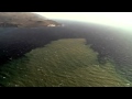
Volgens de autoriteiten betekent deze seismische activiteit nog niet direct dat een grotere, significante aardbeving zal plaatsvinden. Het merendeel van de bevingen die zijn geregistreerd, vonden plaats in het Noord Westen van het 280 vierkante kilometer kleine eilandje, bij het plaatsje El Golfo (zie foto hieronder). Een aardbeving op deze plaats zorgde er zo’n 50.000 jaar geleden voor, dat er een enorme landverschuiving plaatsvond, waarbij de helft van de vulkaan in zee gleed. Hierdoor ontstond een ca. 100 meter hoge tsunami die naar de overzijde van de Atlantische oceaan zou zijn gegleden. Schuin tegenover dit eilandje, in het verlengde van de resterende halve kratermond, ligt het Noord Amerikaanse continent..
quote:El Hierro Earthquake Swarm Enters Third Week
The intensity of earthquakes recorded on the smallest of the Canary Islands, El Hierro, has increased slightly during the last 24 hours. However, the total number of earthquakes recorded daily has lessened since the earthquake swarm initially began on 17 July.
The total number of tremors recorded during the past two weeks has now exceeded 1,050, according to the Instituto Geografico Nacional (IGN).
The majority of the earth tremors ranged between 1-2 magnitude, but during the past 24 hours there have been least five tremors measuring in excess of 2.0 magnitude on the Richter Scale. A 2.4 magnitude earthquake was recorded at 4:56 p.m. local time on Sunday (31 July 2011).
Approximately 50 earth tremors were recorded on Sunday, according to local earthquake monitoring agency Actualidad Volcánica de Canarias (AVCAN). The number is slightly down on the number of tremors recorded on Saturday and significantly less than the 195 earthquakes recorded on 22 July.
quote:The vast majority of the tremors have been recorded in the northwest of the 278.5-square-kilometre island at El Golfo, the location of a massive landslide that created a 100-metre high tsunami almost 50,000 years ago.
The earthquake swarm, prompted the Canary Islands Government to convene the first ever meeting on 22 July of the Steering Committee and Volcanic Monitoring, reflected in the Specific Plan Protection Civil and Emergency for Volcanic Risk, given what it described “the significant increase in seismic activity”. The Committee met again on Friday 29 July to discuss the low magnitude seismic activity. It reported that it had stepped up its seismic monitoring operations to identify the source of the earthquakes.
Following an evaluation of seismic and volcanological information gathered by the IGN and volcanological Institute of the Canary Islands, the Committee agreed to activate “monitoring and surveillance mechanisms necessary to coordinate the actions of civilian self-protection and information to people listed in the Plan” (translated from Spanish press release). It remains unclear, however, if the unprecedented seismic activitiy on El Hierro is a precursor to a possible future increase in earthquake or volcanic activity.
Earthquake swarms are events where a local area experiences sequences of many earthquakes striking in a relatively short period of time. The length of time used to define the swarm itself varies, but the United States Geological Survey (USGS) points out that an event may last for days, weeks, or months.
El Hierro’s Volcanic/Seismic Past
El Hierro is situated in the most southwestern extreme of the Canaries. The island was formed after three successive eruptions, and consequent accumulations, the island emerged from the ocean as an imposing triangular pyramid crowned by a volcano more than 2,000 metres high.
The volcanic activity, principally at the convergence of the three ridges, resulted in the continual expansion of the island. A mere 50,000 years ago, as a result of seismic tremors which produced massive landslides, a giant piece of the island cracked off, crashed down into the ocean and scattered along the seabed. This landslide of more than 300km3 gave rise to the impressive amphitheatre of the El Golfo valley and at the same time caused a tsunami that most likely rose over 100 metres high and probably reached as far as the American coast.


Links
Live webcams op het eiland El Hierro
Actuele seismische activiteit
AVCan - vulcanologiesch instituut Canarische eilanden
Spaans geografisch instituut
Canariesnews
Tumbit
en op twitter kun je zoeken op #hierro, #elhierro of #viveelhierro
@noticiacanaria Wel veel ander nieuws
@canariesnews
@eruptionsblog
@teideano 1 van de onderzoekers op El Hierro
Gerelateerde topics
[Vulkanen] The ring of fire #6: Waar diverse vulkanen puffen
Aardbevingen #13
Mega tsunami door in zee vallen van eiland La Palma?
[ Bericht 4% gewijzigd door bwt op 08-12-2011 15:40:43 ]
<a href="http://goo.gl/q8fhTe" target="_blank">FAQ?</a>
<a href="http://goo.gl/gYvZFq" target="_blank">Geel is een zonnige en vrolijke kleur, als hij tenminste enigszins warm is gekleurd en wat naar het oranje neigt</a>
<a href="http://goo.gl/gYvZFq" target="_blank">Geel is een zonnige en vrolijke kleur, als hij tenminste enigszins warm is gekleurd en wat naar het oranje neigt</a>
quote:NOTE AVCAN 343 - EARTHQUAKE ACTIVITY-VOLCANIC - HIERRO ISLAND - 25 November 2011-10:30 h peninsular - seismic-volcanic activity continues with moderate to high seismicity in the Gulf marine area. According to the PEVOLCA have appeared "quite often a type of volcanic signals (LP). Continued significant volcanic tremor signal in the Restinga area, which remains small amplitude oscillations, more unstable and more explosions, possibly hydromagmatic . the magnitude of the earthquakes between 3.1 and 1.5. New quakes 6. earthquakes senses 1. Depths one to 15, and the rest to 20km. the day before yesterday 21. Yesterday 8. Today van 4. A total of 11,807 earthquakes are located in El Hierro by IGN from 9:00 am of July 19, 2011 (Enrique).
<a href="http://goo.gl/q8fhTe" target="_blank">FAQ?</a>
<a href="http://goo.gl/gYvZFq" target="_blank">Geel is een zonnige en vrolijke kleur, als hij tenminste enigszins warm is gekleurd en wat naar het oranje neigt</a>
<a href="http://goo.gl/gYvZFq" target="_blank">Geel is een zonnige en vrolijke kleur, als hij tenminste enigszins warm is gekleurd en wat naar het oranje neigt</a>
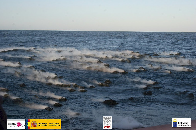
quote:The truth is that the photos of non-tip / Guardia Civil of the last day November 23, 2011 are beautiful, and one more thing to show us how small is the nucleus of the Restinga, at the foot of a volcanic cone aligned with other more behind and in line with the town, besides the spot next to the town, the thing is close, too much for my taste, so if the picture is very good, is a cover of National Georgraphic so far indicating eruption in el Hierro (Enrique).
Picture of intense volcanic gas discharge by submarine eruptive activity south of the Restinga on the morning of November 23, 2011. Photo: Civil Guard / InVolCan

quote:Todo se cuadra para la erupción en el norte
The great stain that is leaving the volcano on La Restinga overshadowed on Thursday what is happening in the north of El Hierro, where the location of small tremors in the seismicity and the increase in the rate of CO2 targets shallower magma movements.
The seismicity in the north of El Hierro is decreasing to the point that this Thursday there were only three earthquakes, however, and according to the committee of scientific work to the direction of the Civil Protection Plan for Volcanic Risk (Pevolca) have appeared "quite often a type of volcanic signals (lp) in the Stations of the North Coast." These signals volcanic long period (long period) are equivalent to small tremors associated interrupted movement of magma.
The director of the National Geographic Institute (IGN), María José Blanco, rejected that means full already tremor signal in the north and, therefore, a rash, but admitted that the magma is moving appreciably off the coast . And it does more superficial positions if one looks at it this concatenation of small tremors is linked to a shallower seismicity in recent days in the north, between 15 and 18 kilometers deep.
Furthermore, these two elements adds an increased gas pressure in the magmatic thermal system. The last measurement of the diffuse emission of carbon dioxide (CO2) from the Canary Islands volcanological Institute (Pevolca) on day 20 is around 2,200 tonnes per day (400 tons more than four days before), a value equivalent to 6.34 times the normal average value on the island.
CO2 is the driving force of eruptions, which is why some experts have the feeling that they may be facing an eruptive phase in the north.
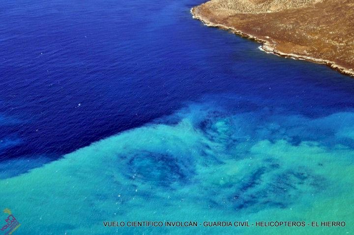
quote:Clouds and transit seismic hypocenters of seismicity to 11/24/2011
Clouds of seismic events and daily traffic of seismicity for seismic-volcanic crisis on the island of El Hierro to 24 November. of 2011

[ Bericht 13% gewijzigd door bwt op 25-11-2011 13:53:59 ]
<a href="http://goo.gl/q8fhTe" target="_blank">FAQ?</a>
<a href="http://goo.gl/gYvZFq" target="_blank">Geel is een zonnige en vrolijke kleur, als hij tenminste enigszins warm is gekleurd en wat naar het oranje neigt</a>
<a href="http://goo.gl/gYvZFq" target="_blank">Geel is een zonnige en vrolijke kleur, als hij tenminste enigszins warm is gekleurd en wat naar het oranje neigt</a>
quote:The diffuse emission of carbon dioxide by the insular volcanic system is already six times the normal average
The diffuse flux measurements of carbon dioxide (CO2) since last July by scientists at the Institute of the Canary Islands volcanological (involcan) at El Hierro reflect an upward trend in their emission into the atmosphere by the volcano island, which is about the 2,200 tons per day. This is a value equivalent to 6.34 times the normal average for the island of El Hierro, which is 345 tons per day.
On the other hand, as reported in a statement, the stain caused by the underwater eruption off the coast of La Restinga has remained widespread in surface and appreciated "some sporadic changes in hue." The sending center has presented a brown color associated with the emission of fine material. On the tremor signal, its amplitude has remained constant and low throughout the day, with some slight increases and no evidence of any second source of tremor . Similarly, with respect to deformation, the results of processing the data obtained with the GPS stations do not reflect any clear trend in the horizontal components other than the regional. Vertically majority view stations and only a collapse of the Gulf seem to point to stability, mainly in the east. Also, the National Geographic Institute (IGN) confirmed the direction of the Civil Protection Plan for Volcanic Risk (Pevolca), that during this eight earthquakes were located Thursday, with only one of them felt by the population, with an intensity of II. Most of these events are located in the Gulf, aligned in the northeast-southwest in the sea at a depth between 15 and 24 kilometers. The more intense, with a magnitude of 2.8 on the Richter scale, had place at 20:54 hours west of La Frontera at a depth of 16 kilometers. In total, since the day July 17, 2011 11 832 earthquakes have been located.
<a href="http://goo.gl/q8fhTe" target="_blank">FAQ?</a>
<a href="http://goo.gl/gYvZFq" target="_blank">Geel is een zonnige en vrolijke kleur, als hij tenminste enigszins warm is gekleurd en wat naar het oranje neigt</a>
<a href="http://goo.gl/gYvZFq" target="_blank">Geel is een zonnige en vrolijke kleur, als hij tenminste enigszins warm is gekleurd en wat naar het oranje neigt</a>
quote:The evolution curve of the cumulative seismic energy released looks set moderating its rise, releasing less and less energy.
This may be because the system is relaxing or on the contrary it has been re-hitches and a few days ago, since it is still early to rely, as the last time you did this, ended with a 4.6, Will this in the coming days? or else I still relax, releasing less and less energy?
We'll see what happens, but seeing the gases and the deformation does not seem to be relaxed, especially gases (Enrique)
[bron]
<a href="http://goo.gl/q8fhTe" target="_blank">FAQ?</a>
<a href="http://goo.gl/gYvZFq" target="_blank">Geel is een zonnige en vrolijke kleur, als hij tenminste enigszins warm is gekleurd en wat naar het oranje neigt</a>
<a href="http://goo.gl/gYvZFq" target="_blank">Geel is een zonnige en vrolijke kleur, als hij tenminste enigszins warm is gekleurd en wat naar het oranje neigt</a>
quote:Update 26/11 – 12:42
The best you can do at the moment is staring at our webcam. For minutes in a row, we have seen periods of smoking magma. The smoking magma was first seen by reader Hans-Werner who also captured the image on his screen. Hans-Werner has told us also that the webcam was operated in the right direction when it happened. This is also great news to hear as the webcam operators seem to have learned from past critics.
Update 26/11 11:30
Joke reports that her friend, the La Restinga human webcam, has growing fear that a new evacuation is not far away as the stain is very visible from the village this morning (Ian reported the same in his 09:52 update). She thinks that if the wind eventually changes, La Restinga might be in the center of the storm again.
Update 26/11 11:28
- The volcanic earthquakes have picked up their daily work again. Since 09:21 this morning 4 M+1.5 earthquakes have been listed by IGN, the strongest one being a M 2.7 earthquake NW of Frontera
Update 26/11 09:52 Ian Carson reports :
A lot of stain right to coast at La Restinga but no emission points can be seen by me. I don't think the earlier mention of a closer one was true. Harmonic calm.
Update 26/11 09:43
- 3 earthquakes have occurred since midnight, all of them less than 1.5, the reason why these quakes are not listed in the IGN main list. 2 of these quakes had a depth of 14.8 km
- while looking at the webcam for a longer period a lot of mysteries are showing up. Here are a few of them :
- why can toppling waves almost only be spotted in the stain waters ?
- why do we have sudden color change in parts of the stain ?
Update 26/11 09:05
- the beautiful calm Las Calmas sea enables us this morning to trace the eruption vent. The arrow on the picture below is the location were we expect that the vent is (probably) degassing. About 15 to 30 minutes ago, we have spotted here the source of a white stain. Unfortunetely the Telefonica operators have since zoomed more to the left . The Telefonica operators have since zoomed the image and probable stirring action has to be located at the upper right corner.


<a href="http://goo.gl/q8fhTe" target="_blank">FAQ?</a>
<a href="http://goo.gl/gYvZFq" target="_blank">Geel is een zonnige en vrolijke kleur, als hij tenminste enigszins warm is gekleurd en wat naar het oranje neigt</a>
<a href="http://goo.gl/gYvZFq" target="_blank">Geel is een zonnige en vrolijke kleur, als hij tenminste enigszins warm is gekleurd en wat naar het oranje neigt</a>
Pluimpje is momenteel weer weg
In this world of evil and darkness I'm looking for the one girl that has the power to bring light into my heart. A light so pure that my evil thoughts about this world and the people living on it will vanish and I'll finally experience true love.
Das vast weer zo'n drijvende lava brok geweest
<a href="http://goo.gl/q8fhTe" target="_blank">FAQ?</a>
<a href="http://goo.gl/gYvZFq" target="_blank">Geel is een zonnige en vrolijke kleur, als hij tenminste enigszins warm is gekleurd en wat naar het oranje neigt</a>
<a href="http://goo.gl/gYvZFq" target="_blank">Geel is een zonnige en vrolijke kleur, als hij tenminste enigszins warm is gekleurd en wat naar het oranje neigt</a>
ook nu nog steeds lava stenen die omhoog komen.
Linkje naar video van die stenenquote:Data Update 26/11 – 23:42
- A lot of action in the sea means mostly a limited number of earthquakes. Today only 8.
- Depth in between 14.8 and 20.3 km
- Medium harmonic tremor with a limited number of bursts
Ian Carson reports from El Hierro :
I went to La Restinga at first light to see any overnight developments - there weren't any - just the usual stain a bit closer to the shore. After an hour and as it was lovely morning, I went sightseeing. I was returning to La Restigna when I got the message of smoking lava stones.
When I arrived there were little 'bombs coming to the surface intermittently. These got more frequent for a while and then only one every 5 mins. After a while the activity again increased, bright Jacuzzi and many stones coming up, generally smaller than the first batch. Stones were visible on the surface. The affected area seemed to be getting larger and the activity seemed quite intense when I had to leave at 17.40. I look forward to first light ! The Ian Carson images are included in the group below. Click on the image to watch the entire group of pictures.
<a href="http://goo.gl/q8fhTe" target="_blank">FAQ?</a>
<a href="http://goo.gl/gYvZFq" target="_blank">Geel is een zonnige en vrolijke kleur, als hij tenminste enigszins warm is gekleurd en wat naar het oranje neigt</a>
<a href="http://goo.gl/gYvZFq" target="_blank">Geel is een zonnige en vrolijke kleur, als hij tenminste enigszins warm is gekleurd en wat naar het oranje neigt</a>
Earthquake report meld een beving van vannacht op 1,9 KM diepte. Deze is echter niet terug te vinden op de lijst van IGNquote:Data Update 27/11 – 09:14
The activity at the eruption area gets even stronger than before. The webcam operator just zoomed out a little to have a wider scoop. Earthquake-report.com expects more action today. A stronger Jacuzzi and from time to time a swelling geyser type action.
Data Update 27/11 – 08:50
The coast guard boat on the image will have the best pictures. What he does is however very risky as nobody can predict the start of a subaerial phase of the eruption.
Data Update 27/11 – 08:09
- the action which started yesterday by floating smoking stones is continuing this morning, hot pyroclastic material is floating to the surface. Just behind a weak Jacuzzi is formed. All this can be seen on the Telefonica eruption webcam.


quote:NOTE AVCAN 346 - EARTHQUAKE ACTIVITY-VOLCANIC - HIERRO ISLAND - 26 November 2011-21:30 h peninsular - seismic-volcanic activity continues with moderate to high seismicity in the Gulf marine area. Continue an important sign of volcanic tremor in the Restinga area, which is maintained in amplitude with increasing trend (10%) since the last note, with small oscillations and some explosions, possibly hydromagmatic (by the way the pattern has repeated explosions every 3 hours approx). The magnitude of the earthquakes between 2.2 and 1.5. New earthquakes 4. Depths to 17, 19, 19 and 20km. Before yesterday 8. Yesterday 10. Now go 8. A total of 11,821 earthquakes are located in El Hierro by IGN from 9:00 am of July 19, 2011 (Enrique).
NOTE AVCAN 347 - EARTHQUAKE ACTIVITY-VOLCANIC - HIERRO ISLAND - 27 November 2011-11:15 h peninsular - seismic-volcanic activity continues to moderate, with seismicity in the Gulf marine area. Continue an important sign of volcanic tremor in the Restinga area, which is maintained in amplitude with the low tendency (5-10%) since the last note, with small oscillations, and more unstable, with some explosions, possibly hydromagmatic (indeed the pattern of repeated explosions every 3h approx). The magnitude of the earthquakes between 2.3 and 1.1. New earthquakes 11. 17 and 20km depth (and two at 2 and 14km and three to 21, 22 and 25km). The day before yesterday 10. Yesterday 9. Today are 10. A total of 11,832 earthquakes are located in El Hierro by IGN from 9:00 am of July 19, 2011 (Enrique).
[ Bericht 10% gewijzigd door bwt op 27-11-2011 12:20:10 ]
<a href="http://goo.gl/q8fhTe" target="_blank">FAQ?</a>
<a href="http://goo.gl/gYvZFq" target="_blank">Geel is een zonnige en vrolijke kleur, als hij tenminste enigszins warm is gekleurd en wat naar het oranje neigt</a>
<a href="http://goo.gl/gYvZFq" target="_blank">Geel is een zonnige en vrolijke kleur, als hij tenminste enigszins warm is gekleurd en wat naar het oranje neigt</a>
Video van de activiteit van vandaag.
Kustwacht bootje is nu opnieuw bij de "hotspot"
http://hierroendirecto.movistar.es/
[ Bericht 6% gewijzigd door bwt op 27-11-2011 13:13:43 ]

Kustwacht bootje is nu opnieuw bij de "hotspot"
http://hierroendirecto.movistar.es/
[ Bericht 6% gewijzigd door bwt op 27-11-2011 13:13:43 ]
<a href="http://goo.gl/q8fhTe" target="_blank">FAQ?</a>
<a href="http://goo.gl/gYvZFq" target="_blank">Geel is een zonnige en vrolijke kleur, als hij tenminste enigszins warm is gekleurd en wat naar het oranje neigt</a>
<a href="http://goo.gl/gYvZFq" target="_blank">Geel is een zonnige en vrolijke kleur, als hij tenminste enigszins warm is gekleurd en wat naar het oranje neigt</a>

Er gebeurd van alles zo te zien.
Ben benieuwd naar de foto's die gemaakt worden.
Ben benieuwd naar de foto's die gemaakt worden.
<a href="http://goo.gl/q8fhTe" target="_blank">FAQ?</a>
<a href="http://goo.gl/gYvZFq" target="_blank">Geel is een zonnige en vrolijke kleur, als hij tenminste enigszins warm is gekleurd en wat naar het oranje neigt</a>
<a href="http://goo.gl/gYvZFq" target="_blank">Geel is een zonnige en vrolijke kleur, als hij tenminste enigszins warm is gekleurd en wat naar het oranje neigt</a>
Toen de heli wegvloog zag ik een grote groene vlek tevoorschijn komen.
Jammer dat de heli net weg was - zou moie foto's opgeleverd hebben.
Vanaf een uur of 8 lijken de tremors ook weer meer aanwezig te zijn.
Jammer dat de heli net weg was - zou moie foto's opgeleverd hebben.
Vanaf een uur of 8 lijken de tremors ook weer meer aanwezig te zijn.

<a href="http://goo.gl/q8fhTe" target="_blank">FAQ?</a>
<a href="http://goo.gl/gYvZFq" target="_blank">Geel is een zonnige en vrolijke kleur, als hij tenminste enigszins warm is gekleurd en wat naar het oranje neigt</a>
<a href="http://goo.gl/gYvZFq" target="_blank">Geel is een zonnige en vrolijke kleur, als hij tenminste enigszins warm is gekleurd en wat naar het oranje neigt</a>

En de beelden die bij de foto's horen.
En vandaags tremors

En vandaags tremors

<a href="http://goo.gl/q8fhTe" target="_blank">FAQ?</a>
<a href="http://goo.gl/gYvZFq" target="_blank">Geel is een zonnige en vrolijke kleur, als hij tenminste enigszins warm is gekleurd en wat naar het oranje neigt</a>
<a href="http://goo.gl/gYvZFq" target="_blank">Geel is een zonnige en vrolijke kleur, als hij tenminste enigszins warm is gekleurd en wat naar het oranje neigt</a>
quote:Data Update 28/11 – 10:01 – Ian Carson reports
Just had long chat with scientists. Depth of vent yesterday was imprecise according to the captain. Now the real news, a new scientific ocean survey ship is coming tomorrow to map the area. It will also do work in the north (El Golfo region).
Data Update 28/11 08:33
- Harmonic tremor remained strong all night
- Contrary to yesterday, no smoking stones this morning. We have just watched a time lapsed period since the beginning of daylight and no surface activity has been noticed on the webcam
- Ian Carson reports that the usual stain is visible but no stirring activity
- 3 earthquakes since midnight, the strongest one being a M 2.0
- depths in between 17 and 21 km
- weather outlook for today : beautiful weather today, wind blowing from the east, maximum wave height : 0.6 meter, wind speed : 1 to 2 knots only in other words a perfect day for volcano activity spotting
[ Bericht 39% gewijzigd door bwt op 28-11-2011 12:26:18 ]
<a href="http://goo.gl/q8fhTe" target="_blank">FAQ?</a>
<a href="http://goo.gl/gYvZFq" target="_blank">Geel is een zonnige en vrolijke kleur, als hij tenminste enigszins warm is gekleurd en wat naar het oranje neigt</a>
<a href="http://goo.gl/gYvZFq" target="_blank">Geel is een zonnige en vrolijke kleur, als hij tenminste enigszins warm is gekleurd en wat naar het oranje neigt</a>
net weer eens gekeken naar de hoeveelheid bevingen vandaag.quote:@eruptionsblog
New post! Taking a closer look at the mixing magmas erupting from El Hierro in the Canary Islands - a complicated mess: http://www.wired.com/wire(...)-el-hierro-eruption/
WOW
Vanaf 11 uur is het weer volop raak
11 stuks waarvan 7 het laatste uur.
Zwaarste een 2.9
1115294 28/11/2011 13:32:19 27.7987 -18.0564 20 2.9 4 NW FRONTERA.IHI

[ Bericht 21% gewijzigd door bwt op 28-11-2011 16:00:55 ]
<a href="http://goo.gl/q8fhTe" target="_blank">FAQ?</a>
<a href="http://goo.gl/gYvZFq" target="_blank">Geel is een zonnige en vrolijke kleur, als hij tenminste enigszins warm is gekleurd en wat naar het oranje neigt</a>
<a href="http://goo.gl/gYvZFq" target="_blank">Geel is een zonnige en vrolijke kleur, als hij tenminste enigszins warm is gekleurd en wat naar het oranje neigt</a>
Mooie pagina van IGN met de El Hierro eruption foto's
http://www.01.ign.es/ign/(...)os/GaleriaFotos.html
Dit soort brokken komen naar boven. Het wittige is porreusmet gassen er in. Hier komt bij afkoeling water in en het verdrijft de gassen zodat het weer naar de bodem zinkt. (in verschillende formaten zoals e al hebben kunnen zien.)
http://www.01.ign.es/ign/(...)os/GaleriaFotos.html
Dit soort brokken komen naar boven. Het wittige is porreusmet gassen er in. Hier komt bij afkoeling water in en het verdrijft de gassen zodat het weer naar de bodem zinkt. (in verschillende formaten zoals e al hebben kunnen zien.)

<a href="http://goo.gl/q8fhTe" target="_blank">FAQ?</a>
<a href="http://goo.gl/gYvZFq" target="_blank">Geel is een zonnige en vrolijke kleur, als hij tenminste enigszins warm is gekleurd en wat naar het oranje neigt</a>
<a href="http://goo.gl/gYvZFq" target="_blank">Geel is een zonnige en vrolijke kleur, als hij tenminste enigszins warm is gekleurd en wat naar het oranje neigt</a>
Er lijkt iets te gebeuren veel dichter bij de kust. De kwaliteit is niet goed genoeg om er echt iets van te maken, maar dat de Eruptie-cam er op gericht staat, zegt toch wel iets...
Is het normaal dat dit gedoe zo lang duurt? Andere vulkanen duren, voor mijn gevoel althans, een stuk minder lang (of zijn minder lang in het nieuws?).
Hangt heel erg van de vulkaan af. Je hebt vulkanen die 'binnen een paar dagen' tot leven komen. Er zijn vulkanen die heel snel weer uitdoven. Je hebt vulkanen die er jaren over doen eer er een eruptie volgt. Maar je hebt ook vulkanen die jarenlang onafgebroken uitbarsten. Extreem voorbeeld daarvan is de Kilauea-vulkaan op Hawaii, die onafgebroken lava spuwt sinds 1983 (maar daar hoor je uiteraard niet elke dag wat over)
Ik hoop dat mn oud professor Geologie nog leeft en nu op El Hierro zit... Prachtige verhalen altijd over vulkanen maar zelf nog nooit een uitbarsting meegemaakt ..
En het dagelijkse tremor plaatjequote:NOTE AVCAN 350 - EARTHQUAKE ACTIVITY-VOLCANIC - HIERRO ISLAND - 28 November 2011-22:30 h peninsular - volcanic seismic activity continues to moderate-high, with seismicity in the Gulf marine area. Continue an important sign of volcanic tremor in the Restinga area, with an amplitude that has fallen and risen again (down to 30 and up to 15%) since the last note, and with small oscillations, and more unstable (drop to the 20:42 h), with some explosions, possibly hydromagmatic (by the way the pattern has been repeated every 3h explosion approx). The magnitude of the earthquakes between 2.9 and 1.1. New earthquakes 16. Depths between 19 and 21 km (and three to 13, 15 and 17km and another 23km. Before yesterday 9. Yesterday 16. Now go 20. A total of 11,858 earthquakes are located in El Hierro by IGN at 9:00 pm on 19 July 2011 (Enrique).
-----------------------------
I do not know how I will but I think we should agree on a name you can call, if only here, the volcano's so much talk. And if we do it democratically, which seems logical, the volcano located by the team of scientists from the Spanish Institute of Oceanography (IEO) in the South Rift of El Hierro, according to our survey, called Volcano calms. (Fernando)

En vannacht nog een beving van 3.0 geweest op 15 KM diepte.
1115395 29/11/2011 01:59:02 27.7713 -18.0501 15 3.0 4 NW FRONTERA.IHI

Mooie youtube video over onderwater vulkaan ergens anders.quote:El Hierro Volcano Update : 28th November
Scientists from Spains National Geographical Institute (IGN) observing recent activity of the Canary Island of El Hierro have recorded a total of 10 earthquakes over the course of the last 24 Hours (13.00 Sunday - 13.00 Monday GMT).
As with recent days and weeks, the earthquakes were centered around the El Golfo bay area, to the Northwest of Frontera on the northern coast of the island. The recorded magnitudes varied from 1.5 to 2.2 on the richter scale and at depths between 17 - 21kms.
As with the southern coast of the island over recent weeks, an Oceanographic research vessel is due to arrive on the North of the Island to investigate and map the ocean floor in the El Golfo bay and to check for the likelihood of new volcanic vents being created.
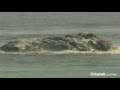
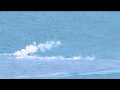
Meanwhile, the Las Calmas bay area, off the coast of La Restinga on the south of the island have seen a development with the volcanic eruptions over the weekend. A new vent appears to have opened up 1.8 km from the coast and this has been accompanied with a marked change in the colour of the stain, together with the emission of sulfurous gasses and the production of a number of smouldering volcanic rocks being brought to the surface of the water.
Maar je kan wel mooi zien hoe die vlekken en drijvende lava bommen ontstaan.

[ Bericht 9% gewijzigd door bwt op 29-11-2011 10:13:29 ]
<a href="http://goo.gl/q8fhTe" target="_blank">FAQ?</a>
<a href="http://goo.gl/gYvZFq" target="_blank">Geel is een zonnige en vrolijke kleur, als hij tenminste enigszins warm is gekleurd en wat naar het oranje neigt</a>
<a href="http://goo.gl/gYvZFq" target="_blank">Geel is een zonnige en vrolijke kleur, als hij tenminste enigszins warm is gekleurd en wat naar het oranje neigt</a>

Het mooie vind ik al die speculaties, niemand weet wat er nog gaat gebeuren.
Het zal allemaal wel met een sisser aflopen
Echt veel heftigs gebeurt er niet......
Het zal allemaal wel met een sisser aflopen
Echt veel heftigs gebeurt er niet......
Er is weer actie - nieuwe uitstoot / nieuwe vent?
Check de cams
Ook is het eerder vermelde onderzoeksschip aangekomen.
http://earthquake-report.com/2011/11/12/32535/
3 in 1 webcam pagina
[ Bericht 77% gewijzigd door bwt op 29-11-2011 11:59:14 ]
Check de cams
Ook is het eerder vermelde onderzoeksschip aangekomen.
http://earthquake-report.com/2011/11/12/32535/
3 in 1 webcam pagina
Een mooiere is die van de IGNquote:NOTE AVCAN 351 - EARTHQUAKE ACTIVITY-VOLCANIC - HIERRO ISLAND - 29 November 2011-11:45 h peninsular - seismic-volcanic activity continues to moderate-high, with seismicity in the Gulf marine area. Continue an important sign of volcanic tremor in the Restinga area, with an amplitude that has remained stable since the last note, and small oscillations and explosions, possibly hydromagmatic (by the way the pattern has repeated explosions every 2 hours approx). The magnitude of the earthquakes between 3.0 and 1.5. New quakes 7. Felt earthquakes 1. Depths to 16, 16, 17, 19, 20 and 23km. The day before yesterday 16. Yesterday 23. Today van 4. A total of 11,865 earthquakes are located in El Hierro by IGN from 9:00 am of July 19, 2011 (Enrique).
For those who are curious as will the "Devil's staircase" or energy ladder or evolution of the cumulative seismic energy released from 4.6 until today, I leave you there, with the last steps of the earthquakes of yesterday and today at the end. By the way the patterns are 48h, and two at each 6h-12h also (Enrique)


[ Bericht 77% gewijzigd door bwt op 29-11-2011 11:59:14 ]
<a href="http://goo.gl/q8fhTe" target="_blank">FAQ?</a>
<a href="http://goo.gl/gYvZFq" target="_blank">Geel is een zonnige en vrolijke kleur, als hij tenminste enigszins warm is gekleurd en wat naar het oranje neigt</a>
<a href="http://goo.gl/gYvZFq" target="_blank">Geel is een zonnige en vrolijke kleur, als hij tenminste enigszins warm is gekleurd en wat naar het oranje neigt</a>
Activiteit lijk weer afgenomen te zijn. Het onderzoekschip is ook weer net binnen/buiten het bereik van de webcams.
Ze zijn ook aardig met het in/uit zoomen bezig met de cams.
Ze zijn ook aardig met het in/uit zoomen bezig met de cams.
<a href="http://goo.gl/q8fhTe" target="_blank">FAQ?</a>
<a href="http://goo.gl/gYvZFq" target="_blank">Geel is een zonnige en vrolijke kleur, als hij tenminste enigszins warm is gekleurd en wat naar het oranje neigt</a>
<a href="http://goo.gl/gYvZFq" target="_blank">Geel is een zonnige en vrolijke kleur, als hij tenminste enigszins warm is gekleurd en wat naar het oranje neigt</a>
Onderzoeks bootje wat voorbij kwam is speciaal voor topografiequote:Decreased daily average depth, though, with only 4 events detected this day 29 half hour ago. The average weight is the result of energy released every event: Summary of the seismicity of day: 11/29/2011
Number of seismic events on the day: 4 at 11:10
Latitude weighted average energy released: 27,771
Average length weighted by energy released: 18,050
Depth-weighted average energy released: 15,416
Seismic energy released during the day: 10723049118099.76563 Joule
Equivalent Magnitude of the day: 3.0126
Average Energy per event day: 2680762279524.941407500 Joule
Average magnitude event of the day: 2,761
[bron]


[ Bericht 16% gewijzigd door bwt op 29-11-2011 12:33:19 ]
<a href="http://goo.gl/q8fhTe" target="_blank">FAQ?</a>
<a href="http://goo.gl/gYvZFq" target="_blank">Geel is een zonnige en vrolijke kleur, als hij tenminste enigszins warm is gekleurd en wat naar het oranje neigt</a>
<a href="http://goo.gl/gYvZFq" target="_blank">Geel is een zonnige en vrolijke kleur, als hij tenminste enigszins warm is gekleurd en wat naar het oranje neigt</a>
quote:The INVOLCAN continues to record an increase in the diffuse emission of CO2 by the volcanic system island of El Hierro
The diffuse emission of carbon dioxide (CO2), at present, the volcano island of El Hierro reaches 2398 ± 115 tons per day
Since last July, scientists at the Institute of Technology and Renewable Energies (ITER), an agency of the Cabildo of Tenerife, and is now part of volcanological Institute of the Canaries (non-tip) have conducted numerous scientific surveys of diffuse emissions volcanic gases that have materialized over the entire surface of the island of Isla Meridian. To date, the results reflect the record of an upward trend of the diffuse emission of carbon dioxide (CO2) into the atmosphere by the volcano island of El Hierro has reached 2398 ± 115 tons per day, an amount equivalent to almost 7 times the normal average value considered for the diffuse emission of carbon dioxide (CO2) in the island of El Hierro (345 tonnes per day).
This increase in the diffuse emission of carbon dioxide (CO2) shows that the pressure of carbon dioxide (CO2) in magmatic-hydrothermal system existing in the island of El Hierro is increasing probably due to magma movement from positions more shallow depth favoring exsolution of carbon dioxide (CO2) dissolved in silicate melts (magma).
The scientific purpose of these campaigns is to investigate spatio-temporal variations of the diffuse emission of carbon dioxide (CO2) into the atmosphere by the volcanic system of El Hierro island since the results thereof can not be obtained through networks permanent instrumental analysis contribute to the evolution of the current eruptive phase is occurring in El Hierro. On the other hand, it is widely accepted that the gases are the driving force of volcanic eruptions and the importance of carbon dioxide (CO2) in volcanic surveillance programs since not only is the second major component of volcanic gases, after steam but its low solubility in molten silicitados (magma) that favors carbon dioxide (CO2) to escape with their ease of volcanic systems in depth.
These scientific surveys have failed to materialize due to MAKAVOL project "Capacity Building of R + D + i + d to contribute to the reduction of volcanic risk in the Macaronesia (MAC/3/C161)" which is being co-funded by the Transnational Cooperation Programme of the European Union Madeira-Canary-Azores (MAC 2007-2013) and the collaboration of the Island Councils of Tenerife and El Hierro.
INVOLCAN is an institution demanded unanimously by the Senate (2005), Parliament of the Canary Islands (2006) and House of Representatives (2009) with the aim of contributing to improving and optimizing the management of volcanic risk in Spain.
Picture Pie
Temporal evolution of the diffuse emission of carbon dioxide (CO2) in the island of El Hierro (red circles) recorded by the Involcan and the daily number of earthquakes located by the National Seismic Network (IGN).

<a href="http://goo.gl/q8fhTe" target="_blank">FAQ?</a>
<a href="http://goo.gl/gYvZFq" target="_blank">Geel is een zonnige en vrolijke kleur, als hij tenminste enigszins warm is gekleurd en wat naar het oranje neigt</a>
<a href="http://goo.gl/gYvZFq" target="_blank">Geel is een zonnige en vrolijke kleur, als hij tenminste enigszins warm is gekleurd en wat naar het oranje neigt</a>
Bootje vaart nog steeds heen en weer voor de webcamsquote:Update 29/11 – 11:26 UTC
User Martin Rey has traced the ship currently navigating in the stain area
New oceanographic boat on La restinga th "Sarmiento de Gamboa".. 70m, its the BEST oceanographic boat that can be send, i think. It's called a "grand Cientific Instalation" by CSIC, its owner.
Update 29/11 12:18 UTC
It is not official, but due to the many ups and downs along the stain, we are almost sure that the Sarmiento de Gamboa is mapping the sea floor very carefully.
- Todays webcam image is rather complicated with a number of stains. We will need an image from a helicopter to find out whether these are Jacuzzis or patches of earlier emitted material.

[ Bericht 4% gewijzigd door bwt op 29-11-2011 15:06:59 ]
<a href="http://goo.gl/q8fhTe" target="_blank">FAQ?</a>
<a href="http://goo.gl/gYvZFq" target="_blank">Geel is een zonnige en vrolijke kleur, als hij tenminste enigszins warm is gekleurd en wat naar het oranje neigt</a>
<a href="http://goo.gl/gYvZFq" target="_blank">Geel is een zonnige en vrolijke kleur, als hij tenminste enigszins warm is gekleurd en wat naar het oranje neigt</a>
En ik weet niet of het volgende plaatje de nieuwe of oude situatie isquote:NOTE AVCAN 352 - EARTHQUAKE ACTIVITY-VOLCANIC - HIERRO ISLAND - 29 November 2011-22:00 h peninsular - seismic-volcanic activity continues to moderate-high, with seismicity in the Gulf marine area. Continue an important sign of volcanic tremor in the Restinga area, with an amplitude that has remained stable since the last note, and small oscillations and explosions, possibly hydromagmatic (by the way the pattern has repeated explosions ever closer, each hours approx). The magnitude of the earthquakes between 2.2 and 1.0. New earthquakes 4. Depths to 15, 16, 18 and 22km. The day before yesterday 16. Yesterday 23. Now go 8. A total of 11,869 earthquakes are located in El Hierro by IGN from 9:00 am of July 19, 2011 (Enrique).

<a href="http://goo.gl/q8fhTe" target="_blank">FAQ?</a>
<a href="http://goo.gl/gYvZFq" target="_blank">Geel is een zonnige en vrolijke kleur, als hij tenminste enigszins warm is gekleurd en wat naar het oranje neigt</a>
<a href="http://goo.gl/gYvZFq" target="_blank">Geel is een zonnige en vrolijke kleur, als hij tenminste enigszins warm is gekleurd en wat naar het oranje neigt</a>
Er zijn weer mooie plaatjes van gister - 29-11-2011
Zo zijn er ook mooie video's te vinden op de FB pagina's --- en hier de originele foto's
[ Bericht 3% gewijzigd door bwt op 30-11-2011 13:53:52 ]


Zo zijn er ook mooie video's te vinden op de FB pagina's --- en hier de originele foto's
[ Bericht 3% gewijzigd door bwt op 30-11-2011 13:53:52 ]
<a href="http://goo.gl/q8fhTe" target="_blank">FAQ?</a>
<a href="http://goo.gl/gYvZFq" target="_blank">Geel is een zonnige en vrolijke kleur, als hij tenminste enigszins warm is gekleurd en wat naar het oranje neigt</a>
<a href="http://goo.gl/gYvZFq" target="_blank">Geel is een zonnige en vrolijke kleur, als hij tenminste enigszins warm is gekleurd en wat naar het oranje neigt</a>


En de video's van het INVOLCAN Youtube kanaal
[ Bericht 2% gewijzigd door bwt op 30-11-2011 15:53:30 ]


[ Bericht 2% gewijzigd door bwt op 30-11-2011 15:53:30 ]
<a href="http://goo.gl/q8fhTe" target="_blank">FAQ?</a>
<a href="http://goo.gl/gYvZFq" target="_blank">Geel is een zonnige en vrolijke kleur, als hij tenminste enigszins warm is gekleurd en wat naar het oranje neigt</a>
<a href="http://goo.gl/gYvZFq" target="_blank">Geel is een zonnige en vrolijke kleur, als hij tenminste enigszins warm is gekleurd en wat naar het oranje neigt</a>
Ik zie zelfs pluimpjes omhoog schieten.
btw. er zijn weer nieuwe foto's - http://www.facebook.com/m(...)4042953295772&type=1
En hier ook foto's - http://www.facebook.com/m(...)4042953295772&type=1
btw. er zijn weer nieuwe foto's - http://www.facebook.com/m(...)4042953295772&type=1

En hier ook foto's - http://www.facebook.com/m(...)4042953295772&type=1

<a href="http://goo.gl/q8fhTe" target="_blank">FAQ?</a>
<a href="http://goo.gl/gYvZFq" target="_blank">Geel is een zonnige en vrolijke kleur, als hij tenminste enigszins warm is gekleurd en wat naar het oranje neigt</a>
<a href="http://goo.gl/gYvZFq" target="_blank">Geel is een zonnige en vrolijke kleur, als hij tenminste enigszins warm is gekleurd en wat naar het oranje neigt</a>
Nog steeds niet?
Ik zit de hele tijd te kijken.
Lijkt er op dat ik me net zoveel verveel als degene in het bootje, die varen ook maar heen en weer
http://earthquake-report.com/2011/11/12/32535/
webcam 2
Ik zit de hele tijd te kijken.
Lijkt er op dat ik me net zoveel verveel als degene in het bootje, die varen ook maar heen en weer
http://earthquake-report.com/2011/11/12/32535/
webcam 2
jij boefjequote:
Inorbit: zeg dat dan typluie triangeljosti
Beauregard: Een beetje FOK!ker laat het brood door z'n moeder smeren.
Ecosia
ek's 'n flash drive, jy's 'n floppy
Beauregard: Een beetje FOK!ker laat het brood door z'n moeder smeren.
Ecosia
ek's 'n flash drive, jy's 'n floppy

Als de webcam verbinding heeft kun je dit zo af en toe zien.
Camera lijkt het weer half te doen.
[ Bericht 4% gewijzigd door bwt op 01-12-2011 12:23:03 ]
<a href="http://goo.gl/q8fhTe" target="_blank">FAQ?</a>
<a href="http://goo.gl/gYvZFq" target="_blank">Geel is een zonnige en vrolijke kleur, als hij tenminste enigszins warm is gekleurd en wat naar het oranje neigt</a>
<a href="http://goo.gl/gYvZFq" target="_blank">Geel is een zonnige en vrolijke kleur, als hij tenminste enigszins warm is gekleurd en wat naar het oranje neigt</a>
Over vandaag
[google translate]
[ Bericht 19% gewijzigd door bwt op 01-12-2011 15:45:45 ]
[google translate]
1,5 uur in iets meer dan 4 minutenquote:The volcano of La Restinga eject large rocks again
The volcano has returned to La Restinga eject large chunks of solidified lava. The focus cameras 24 hours a bubbling area captured from the first morning, however, "were no more than 20 or 30 rocks" that emerged, says a spokeswoman for the National Geographic Institute (IGN), Carmen Lopez .
A IGN researchers did not give time to collect samples because they could not approach the area due to the strong prevailing wind and the rocks sank quickly, its large size. Carmen Lopez and IGN technicians arrived near the eruptive Salvamar aboard and found that washes out "smoking" in the midst of a "much bubbling" by the emission of "greenhouse and very fine and dense material."
The expulsion of solid material lasted less than two hours. At the moment only seen a bubble in the focal zone eruption.

[ Bericht 19% gewijzigd door bwt op 01-12-2011 15:45:45 ]
<a href="http://goo.gl/q8fhTe" target="_blank">FAQ?</a>
<a href="http://goo.gl/gYvZFq" target="_blank">Geel is een zonnige en vrolijke kleur, als hij tenminste enigszins warm is gekleurd en wat naar het oranje neigt</a>
<a href="http://goo.gl/gYvZFq" target="_blank">Geel is een zonnige en vrolijke kleur, als hij tenminste enigszins warm is gekleurd en wat naar het oranje neigt</a>
En er zijn weer nieuwe plaatjes op het picasa album van earthquake report.
en de originelen
[ Bericht 8% gewijzigd door bwt op 02-12-2011 09:45:33 ]

en de originelen
[ Bericht 8% gewijzigd door bwt op 02-12-2011 09:45:33 ]
<a href="http://goo.gl/q8fhTe" target="_blank">FAQ?</a>
<a href="http://goo.gl/gYvZFq" target="_blank">Geel is een zonnige en vrolijke kleur, als hij tenminste enigszins warm is gekleurd en wat naar het oranje neigt</a>
<a href="http://goo.gl/gYvZFq" target="_blank">Geel is een zonnige en vrolijke kleur, als hij tenminste enigszins warm is gekleurd en wat naar het oranje neigt</a>
bij mij werkt het probleemloos
http://hierroendirecto.movistar.es/
En nieuwe video - geluid uit want de heli maakt veel lawaai.
[ Bericht 72% gewijzigd door bwt op 02-12-2011 11:50:08 ]
http://hierroendirecto.movistar.es/
En nieuwe video - geluid uit want de heli maakt veel lawaai.

[ Bericht 72% gewijzigd door bwt op 02-12-2011 11:50:08 ]
<a href="http://goo.gl/q8fhTe" target="_blank">FAQ?</a>
<a href="http://goo.gl/gYvZFq" target="_blank">Geel is een zonnige en vrolijke kleur, als hij tenminste enigszins warm is gekleurd en wat naar het oranje neigt</a>
<a href="http://goo.gl/gYvZFq" target="_blank">Geel is een zonnige en vrolijke kleur, als hij tenminste enigszins warm is gekleurd en wat naar het oranje neigt</a>
Hoe je het ook bekijkt - het is de laatste paar dagen erg rustig rond de eruptie.
Bijna geen bevingen. Tremors die redelijk rustig zijn.
Als je ook kijkt naar de vervormingen dan lijkt alles weer terug naar normale waarden te keren.
Enige wat nog een beetje aanwezig blijft zijn de hogere CO2 waardes.
De bevingen van de laatste 36 uur. Zijn er niet veel
En van de afgelopen 4 dagen.
[ Bericht 44% gewijzigd door bwt op 03-12-2011 11:18:46 ]
Bijna geen bevingen. Tremors die redelijk rustig zijn.
Als je ook kijkt naar de vervormingen dan lijkt alles weer terug naar normale waarden te keren.
Enige wat nog een beetje aanwezig blijft zijn de hogere CO2 waardes.
De bevingen van de laatste 36 uur. Zijn er niet veel

En van de afgelopen 4 dagen.

quote:Graphic which aims to present each day as if there had been an earthquake and the earthquake alone would be equivalent to the sum of the rest of earthquakes a day.
This is to compare the energy released (presented as magnitude), with the average depth of daily events, the average magnitude of the events and the number of events have occurred in the day.
To calculate the average depth, it is weighted by the energy released by each event. (JR)
[bron]

[ Bericht 44% gewijzigd door bwt op 03-12-2011 11:18:46 ]
<a href="http://goo.gl/q8fhTe" target="_blank">FAQ?</a>
<a href="http://goo.gl/gYvZFq" target="_blank">Geel is een zonnige en vrolijke kleur, als hij tenminste enigszins warm is gekleurd en wat naar het oranje neigt</a>
<a href="http://goo.gl/gYvZFq" target="_blank">Geel is een zonnige en vrolijke kleur, als hij tenminste enigszins warm is gekleurd en wat naar het oranje neigt</a>
Het is rustig en rustiger en rustiger.
Zelfs geen bevingen sinds middernacht....
Zelfs geen bevingen sinds middernacht....
<a href="http://goo.gl/q8fhTe" target="_blank">FAQ?</a>
<a href="http://goo.gl/gYvZFq" target="_blank">Geel is een zonnige en vrolijke kleur, als hij tenminste enigszins warm is gekleurd en wat naar het oranje neigt</a>
<a href="http://goo.gl/gYvZFq" target="_blank">Geel is een zonnige en vrolijke kleur, als hij tenminste enigszins warm is gekleurd en wat naar het oranje neigt</a>
Maar tegelijkertijd is de vlek in het water nog steeds onverminderd actief. CO2 levels zijn ook nog steeds hoog.
Desondanks lijkt het het begin van het einde, aangezien de situatie ook minder veranderlijk is dan voorheen, nog los van het ontbreken van de aardbevingen
Desondanks lijkt het het begin van het einde, aangezien de situatie ook minder veranderlijk is dan voorheen, nog los van het ontbreken van de aardbevingen
een van de weinige dingen die vandaag gebeurd zijn, volgens earthquake report
Hoewel de tremors eind van de dag nog aan het opleven zijn gegaan.....
[ Bericht 23% gewijzigd door bwt op 04-12-2011 22:36:39 ]

Hoewel de tremors eind van de dag nog aan het opleven zijn gegaan.....

quote:NOTE AVCAN 362 - EARTHQUAKE ACTIVITY-VOLCANIC - HIERRO ISLAND - DECEMBER 04 2011-22:00 h peninsular - seismic-volcanic activity continues to moderate, with seismicity in the del Golfo marine area. Continue an important sign of volcanic tremor in the Restinga area, with an amplitude which remained stable since the last, least the last 2 hours starting at 7:50 p.m. or so where it has doubled in intensity by a possible jam in the pipe and swings and more explosions, possibly hydromagmatic. The magnitude of the earthquake only 1.4. New earthquakes 1. Depths at 17km. Before yesterday 5. Yesterday 3. Today van 2. A total of 11,909 earthquakes are located in El Hierro by IGN from 9:00 am of July 19, 2011 (Enrique).
[bron]
[ Bericht 23% gewijzigd door bwt op 04-12-2011 22:36:39 ]
<a href="http://goo.gl/q8fhTe" target="_blank">FAQ?</a>
<a href="http://goo.gl/gYvZFq" target="_blank">Geel is een zonnige en vrolijke kleur, als hij tenminste enigszins warm is gekleurd en wat naar het oranje neigt</a>
<a href="http://goo.gl/gYvZFq" target="_blank">Geel is een zonnige en vrolijke kleur, als hij tenminste enigszins warm is gekleurd en wat naar het oranje neigt</a>
En de treomors voor vandaag:

<a href="http://goo.gl/q8fhTe" target="_blank">FAQ?</a>
<a href="http://goo.gl/gYvZFq" target="_blank">Geel is een zonnige en vrolijke kleur, als hij tenminste enigszins warm is gekleurd en wat naar het oranje neigt</a>
<a href="http://goo.gl/gYvZFq" target="_blank">Geel is een zonnige en vrolijke kleur, als hij tenminste enigszins warm is gekleurd en wat naar het oranje neigt</a>

quote:The diffuse emission of CO2 by the volcanic system of El Hierro island falls under the INVOLCAN
This downward trend since late November until now arriving at 1560 ± 59 tonnes per day
Since last July, scientists at the Institute of Technology and Renewable Energies (ITER), an agency of the Cabildo of Tenerife, and is now part of volcanological Institute of the Canaries (INVOLCAN) have conducted numerous scientific surveys of diffuse emissions volcanic gases that have materialized over the entire surface of the island of Isla Meridian. The results show a downward trend in the diffuse emission of carbon dioxide (CO2) into the atmosphere by the volcano island of El Hierro since late November, when it came to achieving the 2398 ± 115 tons per day, up to now been recorded an emission rate of 1,560 ± 59 tonnes per day.
This record to the bottom of the diffuse emission of carbon dioxide (CO2) in turn implies that the pressure of carbon dioxide (CO2) in volcanic-magmatic system existing in the hydrothermal-island of El Hierro should not continue to grow as well it might be inferred during the observation period was experiencing an increase in the diffuse emission of carbon dioxide (CO2).
The scientific purpose of these campaigns is to investigate spatio-temporal variations of the diffuse emission of carbon dioxide (CO2) into the atmosphere by the volcanic system of El Hierro island since the results thereof can not be obtained through networks permanent instrumental analysis contribute to the evolution of the current eruptive phase is occurring in El Hierro. On the other hand, it is widely accepted that the gases are the driving force of volcanic eruptions and monitoring of carbon dioxide (CO2) in volcanic surveillance programs is very important because not only is the second major component of volcanic gases after water vapor, but also because of its low solubility in molten silicitados (magma) favoring the carbon dioxide (CO2) to escape with their ease of volcanic systems in depth.
These scientific surveys have failed to materialize due to MAKAVOL project "Capacity Building of R + D + i + d to contribute to the reduction of volcanic risk in the Macaronesia (MAC/3/C161)" which is being co-funded by the Transnational Cooperation Programme of the European Union Madeira-Canary-Azores (MAC 2007-2013) and the collaboration of the Island Councils of Tenerife and El Hierro.
INVOLCAN is an institution demanded unanimously by the Senate (2005), Parliament of the Canary Islands (2006) and House of Representatives (2009) with the aim of contributing to improving and optimizing the management of volcanic risk in Spain.
Picture Pie
Temporal evolution of the diffuse emission of carbon dioxide (CO2) in the island of El Hierro (red circles) recorded by the non-tip and the daily number of earthquakes located by the National Seismic Network (IGN).
[bron]
<a href="http://goo.gl/q8fhTe" target="_blank">FAQ?</a>
<a href="http://goo.gl/gYvZFq" target="_blank">Geel is een zonnige en vrolijke kleur, als hij tenminste enigszins warm is gekleurd en wat naar het oranje neigt</a>
<a href="http://goo.gl/gYvZFq" target="_blank">Geel is een zonnige en vrolijke kleur, als hij tenminste enigszins warm is gekleurd en wat naar het oranje neigt</a>
Mijn bovenstaande plaatje geeft het al aan.
quote:The Involcan shows a decrease in the diffuse emission of CO2 by the volcanic system
Scientists at the Institute of Technology and Renewable Energies (ITER), an agency of the Cabildo of Tenerife, and is now part of volcanological Institute of the Canaries (Involcan), indicate a downward trend of the diffuse emission of carbon dioxide (CO2) into the atmosphere by the volcano island of El Hierro since late November, when it came to achieving the 2398 ± 115 tons per day, up to now been recorded an emission rate of 1,560 ± 59 tonnes per day.
This record to the bottom of the diffuse emission of CO2 in turn implies that the pressure of CO2 in the system magmatic-hydrothermal volcanic-existing in the island "should not continue to grow as well it might be inferred during the period of observation was experiencing an increase in the diffuse emission of CO2. "
The Involcan said in a statement that the purpose of these campaigns is to investigate scientific spatiotemporal variations of the diffuse emission of carbon dioxide into the atmosphere by the volcanic system since the results can not be obtained through permanent instrumental network developments contribute to the analysis of the current eruptive phase is occurring in El Hierro.
[bron]
<a href="http://goo.gl/q8fhTe" target="_blank">FAQ?</a>
<a href="http://goo.gl/gYvZFq" target="_blank">Geel is een zonnige en vrolijke kleur, als hij tenminste enigszins warm is gekleurd en wat naar het oranje neigt</a>
<a href="http://goo.gl/gYvZFq" target="_blank">Geel is een zonnige en vrolijke kleur, als hij tenminste enigszins warm is gekleurd en wat naar het oranje neigt</a>
De nieuwe webcam:
http://www.rtvc.es/volcanelhierro/volcanendirecto.aspx
En de 3 reeds bekende webcams
http://earthquake-report.com/2011/11/12/32535/
http://www.rtvc.es/volcanelhierro/volcanendirecto.aspx
En de 3 reeds bekende webcams
http://earthquake-report.com/2011/11/12/32535/
<a href="http://goo.gl/q8fhTe" target="_blank">FAQ?</a>
<a href="http://goo.gl/gYvZFq" target="_blank">Geel is een zonnige en vrolijke kleur, als hij tenminste enigszins warm is gekleurd en wat naar het oranje neigt</a>
<a href="http://goo.gl/gYvZFq" target="_blank">Geel is een zonnige en vrolijke kleur, als hij tenminste enigszins warm is gekleurd en wat naar het oranje neigt</a>
De beelden van gister

<a href="http://goo.gl/q8fhTe" target="_blank">FAQ?</a>
<a href="http://goo.gl/gYvZFq" target="_blank">Geel is een zonnige en vrolijke kleur, als hij tenminste enigszins warm is gekleurd en wat naar het oranje neigt</a>
<a href="http://goo.gl/gYvZFq" target="_blank">Geel is een zonnige en vrolijke kleur, als hij tenminste enigszins warm is gekleurd en wat naar het oranje neigt</a>
En de tremors voor vandaag

<a href="http://goo.gl/q8fhTe" target="_blank">FAQ?</a>
<a href="http://goo.gl/gYvZFq" target="_blank">Geel is een zonnige en vrolijke kleur, als hij tenminste enigszins warm is gekleurd en wat naar het oranje neigt</a>
<a href="http://goo.gl/gYvZFq" target="_blank">Geel is een zonnige en vrolijke kleur, als hij tenminste enigszins warm is gekleurd en wat naar het oranje neigt</a>


Waar zit nu die vilkaan onderwater???
Hier dus:
Hier dus:
<a href="http://goo.gl/q8fhTe" target="_blank">FAQ?</a>
<a href="http://goo.gl/gYvZFq" target="_blank">Geel is een zonnige en vrolijke kleur, als hij tenminste enigszins warm is gekleurd en wat naar het oranje neigt</a>
<a href="http://goo.gl/gYvZFq" target="_blank">Geel is een zonnige en vrolijke kleur, als hij tenminste enigszins warm is gekleurd en wat naar het oranje neigt</a>

Gister avond tussen 21:00 en 22:00 toch weer wat toename in de tremors.
Mogelijk dat er weer wat verassingen aan komen.
- The coincidence of the high H2S levels with the very strong harmonic tremor has to be looked at. A pity we could not see the Las Calmas sea at night. The high values may have been triggered by a very strong Jacuzzi activity.
- The picture below shows a very long lasting burst of activity that started at 21:26 UTC and lasted for about 20 minutes. The signal decreased gradually thereafter but stayed stronger than before the burst
- 2 earthquakes today with epicenter in the El Golfo Bay.
Momenteel weer mooie rookpluimen te zien boven het water.
http://earthquake-report.com/2011/11/12/32535/
http://earthquake-report.com/2011/11/12/32535/
<a href="http://goo.gl/q8fhTe" target="_blank">FAQ?</a>
<a href="http://goo.gl/gYvZFq" target="_blank">Geel is een zonnige en vrolijke kleur, als hij tenminste enigszins warm is gekleurd en wat naar het oranje neigt</a>
<a href="http://goo.gl/gYvZFq" target="_blank">Geel is een zonnige en vrolijke kleur, als hij tenminste enigszins warm is gekleurd en wat naar het oranje neigt</a>
Tremor verdwenen
quote:Update 08/12 – 07:18 UTC
- Harmonic tremor subsided to one of the lowest levels since the eruption started on October 10. After a period of very strong bursts who started yesterday at 22:00 a sudden collapse of harmonic tremor occurred at 04:24 UTC early this morning. We expect that the vent has collapsed due to the strong activity since yesterday evening.
What will happen now ?
–1– As we had almost no earthquakes anymore since many days and as we had only medium harmonic tremor, the chance that the activity was subsiding completely looked real. If this is the case, the earthquakes will not pickup again and the eruption will be over.
–2– If the magma is still very active below El Hierro and as it can not find an opening any longer via the vent, the earthquakes will gradually pickup again from now on. The pace that this happens will give a clue to scientists how much power to expect.
het bijbehorende plaatje van het verdwijnen van de tremors
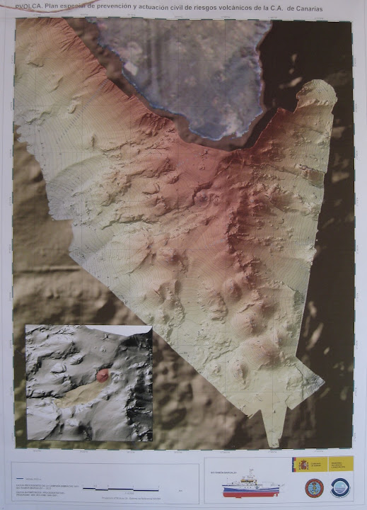
VUELO CIENTÃFICO INVOLCAN - GC 291111 - VOLCÃN SUBMARINO DEL HIERRO - SARMIENTO DE GAMBOA - PANCAM
[ Bericht 40% gewijzigd door bwt op 08-12-2011 10:06:17 ]

Beelden van 7-12-2011quote:Spains National Geological Institute (IGN) Scientists, observing seismic and volcanic activity on the Canary Island of El Hierro have recorded just 2 earthquakes over the course of the last 24 Hours (14.00 hrs Tuesday - 14.00 hrs GMT Wednesday).
Activity has fallen considerably over the last week, with Earthquakes numbering between 2 and 4 per week, compared with an average of 12 per day around one month ago.
As in previous days and weeks, these two Earthquakes took place in and around the El Golfo bay area, off the coast of Frontera to the north of the Island. The Magnitudes recorded registered 1.6 and 1.9 on the richter scale, at depths of 23km and 15km respectively.
Meanwhile, scientists observing the underwater Volcanic eruptions in the Las Calmas bay area, off the coast of La Restinga on the south of the island have told PEVOLCA that the temperature of the sea around the `jacuzzi is beginning to stabilize. Temperatures peaked on the 6th of November with a maximum recording of 30.9 Degrees, but have now returned to an average of 21.3 Degrees.
[bron]

VUELO CIENTÃFICO INVOLCAN - GC 291111 - VOLCÃN SUBMARINO DEL HIERRO - SARMIENTO DE GAMBOA - PANCAM
[ Bericht 40% gewijzigd door bwt op 08-12-2011 10:06:17 ]
<a href="http://goo.gl/q8fhTe" target="_blank">FAQ?</a>
<a href="http://goo.gl/gYvZFq" target="_blank">Geel is een zonnige en vrolijke kleur, als hij tenminste enigszins warm is gekleurd en wat naar het oranje neigt</a>
<a href="http://goo.gl/gYvZFq" target="_blank">Geel is een zonnige en vrolijke kleur, als hij tenminste enigszins warm is gekleurd en wat naar het oranje neigt</a>
ps. ik merk dat ik de OP niet meer kan aanpassen.
Er zijn een een aantal plaatjes die een 403 forbidden opleveren en ik wilde nog wat linkjes toevoegen.
Er zijn een een aantal plaatjes die een 403 forbidden opleveren en ik wilde nog wat linkjes toevoegen.
<a href="http://goo.gl/q8fhTe" target="_blank">FAQ?</a>
<a href="http://goo.gl/gYvZFq" target="_blank">Geel is een zonnige en vrolijke kleur, als hij tenminste enigszins warm is gekleurd en wat naar het oranje neigt</a>
<a href="http://goo.gl/gYvZFq" target="_blank">Geel is een zonnige en vrolijke kleur, als hij tenminste enigszins warm is gekleurd en wat naar het oranje neigt</a>
Het lijkt er toch sterk op dat we een back building hebben op de tremors...
- We wrote the 07:18 update when it was still dark
- Reader Max wrote in our comments at 07:33 : Well, regardless of tremor changes, smoking lava stones are still coming up to the surface at 7:30 camera time. It’s still ongoing.
- and …. indeed tremor is gradually picking up again = the eruption continues

Lava blocks komen nog altijd naar boven:

quote:NOTE AVCAN 369 - EARTHQUAKE ACTIVITY-VOLCANIC - HIERRO ISLAND - DECEMBER 08 2011-12:00 h peninsular - seismic-volcanic activity continues to moderate, with seismicity in the Gulf marine area. Continue an important sign of volcanic tremor in the Restinga area, with high amplitude, unstable and some explosions, possibly even at 04:30 h hydromagmatic where under almost minimum and since then tends to rise and become unstable again. Today has been smoldering pyroclastic output from early in the morning. The magnitude of the earthquake only 1.8. New earthquakes 1. Depth to 22 km. Before yesterday 2. Yesterday 2. Today they 1. A total of 11,919 earthquakes are located in El Hierro by IGN from 9:00 am of July 19, 2011 (Enrique).
[bron]
<a href="http://goo.gl/q8fhTe" target="_blank">FAQ?</a>
<a href="http://goo.gl/gYvZFq" target="_blank">Geel is een zonnige en vrolijke kleur, als hij tenminste enigszins warm is gekleurd en wat naar het oranje neigt</a>
<a href="http://goo.gl/gYvZFq" target="_blank">Geel is een zonnige en vrolijke kleur, als hij tenminste enigszins warm is gekleurd en wat naar het oranje neigt</a>
Qua bevingen is het wel erg rustig
Energie opbouw/ontlading - bevingen
Bevingen laatste 36 uur
[ Bericht 56% gewijzigd door bwt op 08-12-2011 14:21:39 ]
Energie opbouw/ontlading - bevingen
Bevingen laatste 36 uur
quote:Slightly increase the tremor and the stain of La Restinga
The National Geographic Institute (IGN) has confirmed the Civil Protection Plan for Volcanic Risk (Pevolca) yesterday only two earthquakes were located in the area of the Gulf, northwest of La Frontera, with magnitudes of 1.9 and 1.6 on the Richter scale at a depth of 15 and 17 kilometers respectively. None of them was felt by the population. In total, since the day July 17, 2011 11 926 events have been found.
According to IGN, the level of tremor increased in amplitude around 22:00 hours, at which time there was a greater pulse length. Since then remained stable at a level slightly higher than the beginning of the day. As for the studies of ground deformation during the day yesterday continued the same pattern of distortion of previous days, reflecting stability in the components horizontal and vertical component deflation of all stations in the south and east of the island regard to the stain of La Restinga, it is noteworthy that there was an episodic emission steaming lava fragments, but of much less importance than the previous day . IGN adds that the vessel 'Adhara' Maritime Rescue attempted to collect samples but it was not possible due to the remoteness of the area in the emerging area with clean water surface. The spot had a large area throughout the day.
[ Bericht 56% gewijzigd door bwt op 08-12-2011 14:21:39 ]
<a href="http://goo.gl/q8fhTe" target="_blank">FAQ?</a>
<a href="http://goo.gl/gYvZFq" target="_blank">Geel is een zonnige en vrolijke kleur, als hij tenminste enigszins warm is gekleurd en wat naar het oranje neigt</a>
<a href="http://goo.gl/gYvZFq" target="_blank">Geel is een zonnige en vrolijke kleur, als hij tenminste enigszins warm is gekleurd en wat naar het oranje neigt</a>
klopt - alles lijkt stabiel te worden. Dus saaier en steeds minder te melden - En dat wat er is is meer van het zelfde.
The volcano of La Restinga, # ElHierro has three cones attached to each other
The volcano of La Restinga, # ElHierro has three cones attached to each other
<a href="http://goo.gl/q8fhTe" target="_blank">FAQ?</a>
<a href="http://goo.gl/gYvZFq" target="_blank">Geel is een zonnige en vrolijke kleur, als hij tenminste enigszins warm is gekleurd en wat naar het oranje neigt</a>
<a href="http://goo.gl/gYvZFq" target="_blank">Geel is een zonnige en vrolijke kleur, als hij tenminste enigszins warm is gekleurd en wat naar het oranje neigt</a>
ik wacht op een daverend slotstuk
Inorbit: zeg dat dan typluie triangeljosti
Beauregard: Een beetje FOK!ker laat het brood door z'n moeder smeren.
Ecosia
ek's 'n flash drive, jy's 'n floppy
Beauregard: Een beetje FOK!ker laat het brood door z'n moeder smeren.
Ecosia
ek's 'n flash drive, jy's 'n floppy
De lava bol die dreef van de eerdere foto op video vast gelegd:
even blijven kijken voor het resultaat......
even blijven kijken voor het resultaat......

<a href="http://goo.gl/q8fhTe" target="_blank">FAQ?</a>
<a href="http://goo.gl/gYvZFq" target="_blank">Geel is een zonnige en vrolijke kleur, als hij tenminste enigszins warm is gekleurd en wat naar het oranje neigt</a>
<a href="http://goo.gl/gYvZFq" target="_blank">Geel is een zonnige en vrolijke kleur, als hij tenminste enigszins warm is gekleurd en wat naar het oranje neigt</a>
Niet helemaal duidelijk of het nu infrarood is of niet.quote:NOTE AVCAN 370 - EARTHQUAKE ACTIVITY-VOLCANIC - HIERRO ISLAND - DECEMBER 08 2011-23:00 h peninsular - seismic-volcanic activity continues to moderate. Continue an important sign of volcanic tremor in the Restinga area, with high amplitude, unstable and some explosions, possibly even at 04:30 h hydromagmatic where under almost to a minimum and since then tends to rise and become unstable again, making more consistent in the last hours. Today has been smoldering pyroclastic output from early in the morning. No new earthquakes today at Hierro and vicinity. Before yesterday 2. Yesterday 2. Today they 1. A total of 11,919 earthquakes are located in El Hierro by IGN from 9:00 am of July 19, 2011 (Enrique).

<a href="http://goo.gl/q8fhTe" target="_blank">FAQ?</a>
<a href="http://goo.gl/gYvZFq" target="_blank">Geel is een zonnige en vrolijke kleur, als hij tenminste enigszins warm is gekleurd en wat naar het oranje neigt</a>
<a href="http://goo.gl/gYvZFq" target="_blank">Geel is een zonnige en vrolijke kleur, als hij tenminste enigszins warm is gekleurd en wat naar het oranje neigt</a>
gezien de helderheid zou ik zeggen van wel...quote:Op vrijdag 9 december 2011 09:11 schreef bwt het volgende:
[..]
Niet helemaal duidelijk of het nu infrarood is of niet.
[ afbeelding ]
Inorbit: zeg dat dan typluie triangeljosti
Beauregard: Een beetje FOK!ker laat het brood door z'n moeder smeren.
Ecosia
ek's 'n flash drive, jy's 'n floppy
Beauregard: Een beetje FOK!ker laat het brood door z'n moeder smeren.
Ecosia
ek's 'n flash drive, jy's 'n floppy
paar interessante plaatjes gevonden (via twitter) op http://www.montecruz.es/
[ Bericht 42% gewijzigd door bwt op 09-12-2011 09:49:20 ]


quote:NOTE AVCAN 371 - EARTHQUAKE ACTIVITY-VOLCANIC - HIERRO ISLAND - DECEMBER 09 2011-09:00 h peninsular - seismic-volcanic activity continues to moderate, with seismicity in the Gulf marine area. Continue an important sign of volcanic tremor in the Restinga area, with an amplitude that remains slightly higher and slightly unstable and some explosions, possibly hydromagmatic. The magnitude of the earthquakes between 2.0 and 1.8 New earthquakes 2. Depths to 21 and 23km. Before yesterday 2. Yesterday 2. Today they 1. A total of 11,921 earthquakes are located in El Hierro by IGN from 9:00 am of July 19, 2011 (Enrique).
[ Bericht 42% gewijzigd door bwt op 09-12-2011 09:49:20 ]
<a href="http://goo.gl/q8fhTe" target="_blank">FAQ?</a>
<a href="http://goo.gl/gYvZFq" target="_blank">Geel is een zonnige en vrolijke kleur, als hij tenminste enigszins warm is gekleurd en wat naar het oranje neigt</a>
<a href="http://goo.gl/gYvZFq" target="_blank">Geel is een zonnige en vrolijke kleur, als hij tenminste enigszins warm is gekleurd en wat naar het oranje neigt</a>
Scientific flights Involcan - POLICE HELICOPTER ON SUBMARINE VOLCANO AREA OF RESTINGA IN THE SOUTH OF IRON IN THE MORNING OF THE DAY NOVEMBER 8, 2011, MEASURING DISSOLVED GASES IN THE AIR ON THE ERUPTION ZONE HEAT AND TAKING PICTURES . EVOLUTION OF THE SHIP OF OCEANOGRAPHIC INSTITUTE SPANISH "Ramon Margalef" IN THE AREA OF ISSUE UNDERWATER, ULTRASOUND PERFORMING bathymetry and the seabed.

<a href="http://goo.gl/q8fhTe" target="_blank">FAQ?</a>
<a href="http://goo.gl/gYvZFq" target="_blank">Geel is een zonnige en vrolijke kleur, als hij tenminste enigszins warm is gekleurd en wat naar het oranje neigt</a>
<a href="http://goo.gl/gYvZFq" target="_blank">Geel is een zonnige en vrolijke kleur, als hij tenminste enigszins warm is gekleurd en wat naar het oranje neigt</a>
quote:What to expect next ?
Based on Mr. Armas interview and taking into account a number of uncertainties, Earthquake-Report.com expects that :
- if the eruption continues at the present rate and in the same vent, it will take max. 2 weeks to arrive at a depth less than 100 meter. We than expect very strong Jacuzzis during the hydromagmatic bursts.
- if the same process continues for about 3 to 4 weeks and in the same vent we expect regular hydrovolcanic explosions during the bursts.
- if the same process goes on 5 to 6 weeks the eruption may become Surtseyan. This is the most spectacular phase of the eruption. During this phase of the eruption ash and steam clouds can reach hundreds of meters to several km in height. Particular to Surtseyan eruptions are the thick,dark-pointed jets of fragments, often headed by bombs, shot out of the vent.
- if the same process goes on 7 to 8 weeks and in the same vent, the eruption will have created at least a new island
- the main vent is at a safe distance from La Restinga, so we do not see immediate danger for the population. 90% of the time the wind blows from the north or north east at this time of the year and accordingly the eventual ash will be blown further in the Las Calmas sea, avoiding damage at La Restinga..
- If a new island forms, it may indicate several months of uncertainty for the La Restinga population as nobody knows how long the eruption will last and when it will finally stop for a longer time as there may be several new eruptive periods.
Our expectation is based on medium harmonic tremor like we had the last couple of days. In case of strong or very strong harmonic tremor the time to get to these different phases may well be a lot shorter.
If our expectations are coming true, the eruption will make El Hierro appearing in every news show in the world. The island will start to attract visitors from all over the world.
In januari ga ik een weekje naar Tenerife, vandaar uit een dagje naar El Hierro met de veerboot.
Genoeg te zien tegen die tijd als ik de post hierboven moet geloven
Genoeg te zien tegen die tijd als ik de post hierboven moet geloven
Moet zeggen dat die onderwaterwater explosies (magma en water mixen waardoor water stoom wordt en onder zeer grote druk ontsnapt) goed te zien zijn op de tremors.
De volgende is minder duidelijk.
Maar als je per uur kijkt weer wel.
Qua echte bevingen is het wel erg rustig - slechts 4 in de afgelopen 36 uur

De volgende is minder duidelijk.

Maar als je per uur kijkt weer wel.

Qua echte bevingen is het wel erg rustig - slechts 4 in de afgelopen 36 uur
<a href="http://goo.gl/q8fhTe" target="_blank">FAQ?</a>
<a href="http://goo.gl/gYvZFq" target="_blank">Geel is een zonnige en vrolijke kleur, als hij tenminste enigszins warm is gekleurd en wat naar het oranje neigt</a>
<a href="http://goo.gl/gYvZFq" target="_blank">Geel is een zonnige en vrolijke kleur, als hij tenminste enigszins warm is gekleurd en wat naar het oranje neigt</a>
Maar dan moet je wel gaan eiland hoppen met vliegtuig of boot.quote:
In januari ga ik een weekje naar Tenerife, vandaar uit een dagje naar El Hierro met de veerboot.
Genoeg te zien tegen die tijd als ik de post hierboven moet geloven
Vanaf tenerife zul je er niets van merken/zien
<a href="http://goo.gl/q8fhTe" target="_blank">FAQ?</a>
<a href="http://goo.gl/gYvZFq" target="_blank">Geel is een zonnige en vrolijke kleur, als hij tenminste enigszins warm is gekleurd en wat naar het oranje neigt</a>
<a href="http://goo.gl/gYvZFq" target="_blank">Geel is een zonnige en vrolijke kleur, als hij tenminste enigszins warm is gekleurd en wat naar het oranje neigt</a>
Hij zegt toch ook dat hij een dagje El Hierro gaat doen?quote:
[..]
Maar dan moet je wel gaan eiland hoppen met vliegtuig of boot.
Vanaf tenerife zul je er niets van merken/zien
In this world of evil and darkness I'm looking for the one girl that has the power to bring light into my heart. A light so pure that my evil thoughts about this world and the people living on it will vanish and I'll finally experience true love.
Precies, ferry van Los Cristianos op Tenerife naar El Hierro.
Tegen die tijd even uitzoeken hoe het vervoer op El Hierro is geregeld, zal vast wel meer belangstellende trekken deze gebeurtenis
Tegen die tijd even uitzoeken hoe het vervoer op El Hierro is geregeld, zal vast wel meer belangstellende trekken deze gebeurtenis
Och en anders ga je zwemmen :-)
Door de jacuzzie!
Door de jacuzzie!
Inorbit: zeg dat dan typluie triangeljosti
Beauregard: Een beetje FOK!ker laat het brood door z'n moeder smeren.
Ecosia
ek's 'n flash drive, jy's 'n floppy
Beauregard: Een beetje FOK!ker laat het brood door z'n moeder smeren.
Ecosia
ek's 'n flash drive, jy's 'n floppy

Ik ben gewoon scheel.................................quote:
[..]
Hij zegt toch ook dat hij een dagje El Hierro gaat doen?
<a href="http://goo.gl/q8fhTe" target="_blank">FAQ?</a>
<a href="http://goo.gl/gYvZFq" target="_blank">Geel is een zonnige en vrolijke kleur, als hij tenminste enigszins warm is gekleurd en wat naar het oranje neigt</a>
<a href="http://goo.gl/gYvZFq" target="_blank">Geel is een zonnige en vrolijke kleur, als hij tenminste enigszins warm is gekleurd en wat naar het oranje neigt</a>
Anyway. Er blijven in iedergeval weer veel tremors door de mix van lava en water...


<a href="http://goo.gl/q8fhTe" target="_blank">FAQ?</a>
<a href="http://goo.gl/gYvZFq" target="_blank">Geel is een zonnige en vrolijke kleur, als hij tenminste enigszins warm is gekleurd en wat naar het oranje neigt</a>
<a href="http://goo.gl/gYvZFq" target="_blank">Geel is een zonnige en vrolijke kleur, als hij tenminste enigszins warm is gekleurd en wat naar het oranje neigt</a>
Ofwel, niets wijst erop dat de uitbarsting voorbij is.quote:As a matter of fact, most eruptions are preceded by earthquakes, but in most cases the earthquakes stop once the eruption has reached a stable regime. The stopping of earthquakes does not mean that the eruption will stop anytime soon, the eruption might continue for years after the end of significant earthquake activity. Earthquakes are indicative of breaking rocks, caused by magma pushing into areas where there is no established conduit.
Once a stable magma flow occurs through a well-established conduit, there will be no longer any earthquakes.
The cessation of earthquakes only means that the situation has somehow stabilized, not that magma is ceasing to flow.
The real indicator of continued magma flow is volcanic tremor.
Only once the volcanic tremor disappears, then one might reasonably argue that the eruption is over.
- The jacuzzi has been active to very active all day long. The harmonic tremor graph is showing that the eruption is continuing at a steady pace and accordingly that the vent is growing.
- If the process continues at the current level, we expect that one of the coming weeks or even days, the steam bubbles will reach the air and if the vent remains open, the steam will gradually go higher.
- Currently bursts lasting 2 to 4 minutes are occurring every 8 minutes (see picture below for the current time frame).

Deze ochtend is de jacuzzi weer duidelijk aanwezig.
Ook is nu op de http://earthquake-report.com/2011/11/12/32535/ site duidelijk te zien dat er een IR-camera in gebruik is. Wel zo mooi als het geweld wel gaat beginnen.
Ook is nu op de http://earthquake-report.com/2011/11/12/32535/ site duidelijk te zien dat er een IR-camera in gebruik is. Wel zo mooi als het geweld wel gaat beginnen.
quote:NOTE AVCAN 376 - EARTHQUAKE ACTIVITY-VOLCANIC - IRON ISLAND - DECEMBER 11 2011-22:00 h peninsular - seismic-volcanic activity continues to moderate, with seismicity in the Gulf marine area. Continue an important sign of volcanic tremor in the Restinga area, with an amplitude that remains upward (trend in which the last 72 hours and where the intensity has doubled) and presents a growing number explosions, possibly hydromagmatic, every few minutes, a typical strombolian behavior for which establishes a balance between water inlet and outlet of gases in the exhaust duct so that it pulses like a geyser. No new earthquakes located. Before yesterday 2. Yesterday 0. Today is 1. A total of 11,923 earthquakes are located in El Hierro by IGN from 9:00 am of July 19, 2011 (Enrique).
<a href="http://goo.gl/q8fhTe" target="_blank">FAQ?</a>
<a href="http://goo.gl/gYvZFq" target="_blank">Geel is een zonnige en vrolijke kleur, als hij tenminste enigszins warm is gekleurd en wat naar het oranje neigt</a>
<a href="http://goo.gl/gYvZFq" target="_blank">Geel is een zonnige en vrolijke kleur, als hij tenminste enigszins warm is gekleurd en wat naar het oranje neigt</a>
De kans dat we wel wat gaan zien bovenwater komt steeds dichterbij. Mocht dit aanhouden dan denk ik dat de beelden op de webcams er een stuk spannender zullen uitzien.
- NO earthquakes and the eruption continues at the same pace since a couple of days. Harmonic tremor with very strong bursts goes on.
- Very visible stain and Jacuzzi on the webcam (a pity as the eruption webcam has not yet zoomed in). This process will intensify the coming hours, days and weeks as the erupting vent gradually climbs higher. The webcam also shows regular white patches (stronger turbulence NO SLS’s).
- Some people think that if they do not see SLS (Smoking Lava Stones), the eruption is decreasing. This is not the case, the SLS floating on the water in earlier days and weeks are ultralight ash blocks.
- Most of the lava coming out of the vent / crater is pāhoehoe lava (Hawaiian word characterizing most of the lava found on the Hawaiian islands). A pāhoehoe flow typically advances as a series of small lobes and toes that continually break out from a cooled crust. It also forms lava tubes where the minimal heat loss maintains low viscosity. The surface texture of pāhoehoe flows varies widely, displaying all kinds of bizarre shapes often referred to as lava sculpture. We will shortly write an update zooming in on the characteristics of this lava type.
- Joke just told us that Jacuzzi and stain can well be seen from El Pinar, higher on the island. Joke did return to her own house at El Pinar from yesterday afternoon.


Jaja dit klopt wel:
. The webcam also shows regular white patches
Enig idee hoe ver de vulkaan nu onder het oppervlakte ligt?
Laatst wat ik gelezen heb was 70 meter.
. The webcam also shows regular white patches
Enig idee hoe ver de vulkaan nu onder het oppervlakte ligt?
Laatst wat ik gelezen heb was 70 meter.
volgens mij nog 150 meter hoor...quote:Op maandag 12 december 2011 12:14 schreef 1boefje het volgende:
Jaja dit klopt wel:
. The webcam also shows regular white patches
Enig idee hoe ver de vulkaan nu onder het oppervlakte ligt?
Laatst wat ik gelezen heb was 70 meter.
Inorbit: zeg dat dan typluie triangeljosti
Beauregard: Een beetje FOK!ker laat het brood door z'n moeder smeren.
Ecosia
ek's 'n flash drive, jy's 'n floppy
Beauregard: Een beetje FOK!ker laat het brood door z'n moeder smeren.
Ecosia
ek's 'n flash drive, jy's 'n floppy
ergens stond dat er vanaf nu ongeveer 8 weken nodig was om dat stuk te overbruggen. Dus tenzij je zwaar terminaal bent zou het evenuteel nog wel binnen je levensverwachting mogen gebeuren ;-)quote:
Ah, die zie ik dus in mijn leven niet meer boven water komenweer een waste of time
Inorbit: zeg dat dan typluie triangeljosti
Beauregard: Een beetje FOK!ker laat het brood door z'n moeder smeren.
Ecosia
ek's 'n flash drive, jy's 'n floppy
Beauregard: Een beetje FOK!ker laat het brood door z'n moeder smeren.
Ecosia
ek's 'n flash drive, jy's 'n floppy
quote:
Hahaha, laten we dan maar hopen dat er niks tussen komt
Zou het graag zien gebeuren!
quote:- if the same process continues for about 3 to 4 weeks and in the same vent we expect regular hydrovolcanic explosions during the bursts.
- if the same process goes on 5 to 6 weeks the eruption may become Surtseyan. This is the most spectacular phase of the eruption. During this phase of the eruption ash and steam clouds can reach hundreds of meters to several km in height. Particular to Surtseyan eruptions are the thick,dark-pointed jets of fragments, often headed by bombs, shot out of the vent.
- if the same process goes on 7 to 8 weeks and in the same vent, the eruption will have created at least a new island
Inorbit: zeg dat dan typluie triangeljosti
Beauregard: Een beetje FOK!ker laat het brood door z'n moeder smeren.
Ecosia
ek's 'n flash drive, jy's 'n floppy
Beauregard: Een beetje FOK!ker laat het brood door z'n moeder smeren.
Ecosia
ek's 'n flash drive, jy's 'n floppy
5 weken geleden zat de krater op 150 meter diepte. Volgens de berichten zou er nog inderdaad een 7 of 8 weken voor nodig zijn om een eiland te vormen. Dat betekend dat als ik goed reken er totaal een 13 weken voor nodig zijn. De krater groeit 11,5 meter per week meer naar de oppervlakte. Het komt er op neer dat we vanaf die 5 weken nu bijna 60 meter hoger zitten. Dus deze zit waarschijnlijk ongeveer op een 90 meter onder de zeespiegel.
Dus ja de 70 meter zou nog wel eens waar kunnen zijn wanneer de lavastroom toch iets is toegenomen. De druk van het water is uiteraard ook minder geworden. Dus ja. Nogmaals de 70 meter zou wel eens waar kunnen zijn.
[ Bericht 6% gewijzigd door kcgaga op 12-12-2011 14:22:07 ]
Dus ja de 70 meter zou nog wel eens waar kunnen zijn wanneer de lavastroom toch iets is toegenomen. De druk van het water is uiteraard ook minder geworden. Dus ja. Nogmaals de 70 meter zou wel eens waar kunnen zijn.
[ Bericht 6% gewijzigd door kcgaga op 12-12-2011 14:22:07 ]
10 pagina's leesvoerquote:Update 12/12 -13:57 UTC
- As we are currently in a submarine eruption phase with hydromagmatic bursts, we have searched and found a scientific study about such action. In 1984 Kenneth H. Wohletz and Robert McQueen from the USA Los Alamas National Laboratory wrote a paper with the title : “Experimental Studies of Hydromagmatic Volcanism“ [PDF]. We encourage people who want to learn more details about the current phenomena, to read (at least some parts) of this article.
[ Bericht 1% gewijzigd door bwt op 12-12-2011 15:54:26 ]
<a href="http://goo.gl/q8fhTe" target="_blank">FAQ?</a>
<a href="http://goo.gl/gYvZFq" target="_blank">Geel is een zonnige en vrolijke kleur, als hij tenminste enigszins warm is gekleurd en wat naar het oranje neigt</a>
<a href="http://goo.gl/gYvZFq" target="_blank">Geel is een zonnige en vrolijke kleur, als hij tenminste enigszins warm is gekleurd en wat naar het oranje neigt</a>
Hydromagmatic burtst, toevallig mijn vakgebied...

Inorbit: zeg dat dan typluie triangeljosti
Beauregard: Een beetje FOK!ker laat het brood door z'n moeder smeren.
Ecosia
ek's 'n flash drive, jy's 'n floppy
Beauregard: Een beetje FOK!ker laat het brood door z'n moeder smeren.
Ecosia
ek's 'n flash drive, jy's 'n floppy
quote:NOTE AVCAN 377 - EARTHQUAKE ACTIVITY-VOLCANIC - HIERRO ISLAND - DECEMBER 12 2011-11:00 h peninsular - seismic-volcanic activity continues to moderate, with seismicity in the Gulf marine area. Continue an important sign of volcanic tremor in the Restinga area, with a base noise amplitude is maintained upward (trend in which the last 3.5 days and where the intensity has doubled) and ... presents a increasing number of explosions, possibly hydromagmatic every few minutes strombolian typical behavior for which establishes a balance between water inlet and outlet of gases in the exhaust duct so that it pulses like a geyser. No new earthquakes located. Before yesterday 0. Yesterday 1. Now go 0. A total of 11,923 earthquakes are located in El Hierro by IGN from 9:00 am of July 19, 2011 (Enrique).
Mooi plaatje van vanmorgen dus.quote:Update 12/12 -14:58 UTC
The amazing NASA Satellite MODIS picture taken at 11:55 UTC this morning (3 hours ago) is showing a cloud column on the exact place of the vent towards the island. Even we do not believe it ! Is must be a coincidence and if not than we have detected the steaming vent waters. The image cannot have been photoshopped as it has been extracted directly from the NASA website (thanks to Julio del Castillo Rivero for sending us the NASA link).
[ Bericht 33% gewijzigd door bwt op 12-12-2011 16:14:14 ]
<a href="http://goo.gl/q8fhTe" target="_blank">FAQ?</a>
<a href="http://goo.gl/gYvZFq" target="_blank">Geel is een zonnige en vrolijke kleur, als hij tenminste enigszins warm is gekleurd en wat naar het oranje neigt</a>
<a href="http://goo.gl/gYvZFq" target="_blank">Geel is een zonnige en vrolijke kleur, als hij tenminste enigszins warm is gekleurd en wat naar het oranje neigt</a>
