WKN Weer, Klimaat en Natuurrampen
Lees alles over het onstuimige weer op onze planeet, volg orkanen en tornado's, zie hoe vulkanen uitbarsten en hoe Moeder Aarde beeft bij een aardbeving. Alles over de verwoestende kracht van onze planeet en tal van andere natuurverschijnselen.


Het Winterweer in de V.S.
]
De noordoostelijke staten van de USA
De winter in New England staat bekend als een koude winter. De wind is in het winterhalfjaar noordwestelijk en droge arctische lucht uit Canada stroomt ver naar het zuiden. Deze kou-invallen gaan soms gepaard met blizzards. Opdringende warme lucht uit het zuiden zorgt af en toe voor flinke ijzel.
Gemiddeld vriest het bij de Canadese grens in januari zo'n -13 graden. In New Jersey vriest het zo'n 5 graden. In het noordoostelijke puntje van New England daalt in januari de thermometer gemiddeld elke nacht tot -19 graden. De extremen in het gebied liegen er ook niet om. Op 19 januari werd het in Van Buren (Maine) -44,4 graden. Old Forge (New York) mat op 18 februari 1979 zelfs een minimum van -46,7 graden. Het zeewater daalt in januari en februari tot +4 graden in zowel Boston als in New York.
De zuidoostelijke staten van de USA
In de winter komt de gemiddelde kou tot Atlanta. In Maryland, Virginia, de Appalachen en de hoger gelegen staten als Kentucky vriest het veelvuldig. De ergste kou vinden we nog noordelijker in Michigan en Ontario. In West Virginia vinden we de allerlaagste temperatuur van het gebied terug. Op 30 december 1917 daalde in Lewisburg de thermometer tot -38,3 graden.
Het gebied langs de Golf van Mexico beleeft een relatief milde en korte winter. Toch kan het hier soms flink vriezen. Neem bijvoorbeeld de -28 graden die in Corinth (Mississippi) op 30 januari 1966 werd gemeten. In Florida neemt de invloed van de oceaan toe. Dit is vooral merkbaar aan de gemiddelde nachttemperatuur in het zuiden. In zeer uitzonderlijke situatie vriest het hier of valt er sneeuw. Op de Key's komt de temperatuur nooit onder nul. De allerlaagste temperatuur in Florida bedroeg -18,9 graden en werd gemeten in Tallahassee.
De staten Virginia, West Virginia en Maryland krijgen in de winter soms te maken met sneeuwstormen. Deze staan bekend als Nor'easters en komen oktober en april. Ze zijn berucht om de grote hoeveelheid sneeuw, regen en de flinke wind.
Een Nor'easter komt voor als een lagedrukgebied warme vochtige subtropische lucht uit de Golf van Mexico naar het noorden voert. De lucht wordt vermengd met vochtige lucht uit de Atlantische Oceaan. Een hogedrukgebied boven Canada biedt tegenwicht en stuwt arctische lucht naar het zuiden. Daar waar de luchtsoorten bij elkaar komen, ontstaat hevige neerslag.
De meest actieve Nor'easter is de sneeuwstorm die naar het oosten trekt en de straalstroom volgt. Vooral Washington DC, Philadelphia, New York City en Boston worden dan getroffen en krijgen grote hoeveelheden regen en sneeuw te verwerken.
]
Het midden van de Verenigde Staten
De winters in het noorden zijn streng. Bismarck in North Dakota heeft in januari een gemiddelde temperatuur van -12,7 graden. International Falls op de grens van Canada en Minnesota heeft zelfs een gemiddelde januari-temperatuur van -17,2 graden. De nachtelijke temperaturen bedragen hier gemiddeld -23,3 graden en de dagtemperatuur -11,2 graden.
De staten langs de Canadese grens en de Grote Meren krijgen ook in de winter vaak te maken met 'blizzards', die zeer koude lucht aanvoeren vanuit het arctische Canada. Het gebied is dan bedekt met een sneeuwlaag. Veel is dit niet. In januari valt er slechts enkele tientallen millimeters neerslag.
Veel nachten verlopen helder en de aanwezigheid van een sneeuwdek helpt mee aan een lage temperatuur. De allerlaagste temperatuur in North Dakota werd gemeten op 15 februari 1936. In Parshall werd het -51,1 graden. Op 2 februari 1996 gebeurde hetzelfde in Towar, Minnesota.
Naar het zuiden neemt de strengheid van de winter af. Tot in Kansas is de gemiddelde januaritemperatuur onder nul. In Texas loopt deze snel op. Niet alleen de zuidelijke ligging, maar ook de aanwezigheid van de Golf van Mexico speelt daarbij een rol. In Brownsville op de grens met Mexico is het in januari overdag 20,5 graden en incidenteel boven de 33 graden.
Toch krijgen relatief zuidelijk gelegen gebieden 's winters soms te maken met extreme koude situaties, doordat luchtstromen uit het hoge noorden van Canada hun weg zuidwaarts zoeken tussen de Rocky Mountains en de Appalachen. Zo was het in het ogenschijnlijk warme Texas op 3 februari 1933 in Seminole -30,6 graden.
Westen van de Verenigde Staten
In de winter heerst de meeste kou in de hoger gelegen delen van de Rocky Mountains. Arctische lucht uit Canada zorgt voor strenge winters in het noorden, zoals in Montana, Wyoming en Colorado. In Montana richt de snijdend koude wind geregeld slachtingen aan onder de veestapel. De allerlaagste temperatuur in Montana werd gemeten op 20 januari 1954. Op Rogers Pass werd het toen -56,7 graden onder nul.
In Wyoming waar ook lange strenge winters voorkomen, staat het minimumrecord op bijna -53 graden vorst. Het berggebied van Idao, Utah en Colorado is koud en sneeuwachtig. Vooral in Colorado valt veel sneeuw. Temperaturen tot onder de -50 graden zijn incidenteel mogelijk. De hoogvlakte van Nevada is eveneens koud. In Ely op 1900 meter hoogte vriest het in januari 's nachts zo'n -12,5 graden. Dit wordt tevens veroorzaakt door de vele heldere nachten in het gebied.
Warmer is het in Washington en Oregon. Het kan hier behoorlijk vriezen, maar aan zee is de winter relatief mild. De regen valt vooral tussen oktober en april. In de bergen gaat het dan om sneeuw en worden wegen afgesloten.
In het zuidwesten van Californië blijft het winters klimaat aangenaam en vriest het zelden. Het is daar dan ook regentijd. Toch kan de winter flink uithalen. Vooral in de Sierra Nevada is dat het geval. De allerlaagste temperatuur in Californië die is gemeten bedraagt -42,8 graden. In New Mexico tenslotte zijn de winters koel maar niet extreem koud.
]
Alaska
In de noordelijke Amerikaanse staat Alaska heersen verschillende klimaten. Zeestromingen, bergruggen en een lage zonnestand bepalen voornamelijk het klimaat. In het noorden komen poolwoestijnen voor, in het zuiden heerst een mild klimaat dat vergelijkbaar is met Nederland.
Bron:VWKWEB
De bedoeling van dit Topic is om het winterweer in de V.S. te volgen.
B.v. via onderstaande site's
Winter Weather cnn
Google News
temperatuurkaartje V.S.
temperatuurkaartje Alaska
vorige delen:
Topic Winterweer in de V.S: Snow, Blizzards and Storms (2007)
Winterweer in de VS (2008) - IJsstorm en bar winterweer
Winter in de V.S. (2009/2010)
De huidige temperaturen in de V.S.
De huidige temperaturen in Alaska
]
]
 ]
]De noordoostelijke staten van de USA
De winter in New England staat bekend als een koude winter. De wind is in het winterhalfjaar noordwestelijk en droge arctische lucht uit Canada stroomt ver naar het zuiden. Deze kou-invallen gaan soms gepaard met blizzards. Opdringende warme lucht uit het zuiden zorgt af en toe voor flinke ijzel.
Gemiddeld vriest het bij de Canadese grens in januari zo'n -13 graden. In New Jersey vriest het zo'n 5 graden. In het noordoostelijke puntje van New England daalt in januari de thermometer gemiddeld elke nacht tot -19 graden. De extremen in het gebied liegen er ook niet om. Op 19 januari werd het in Van Buren (Maine) -44,4 graden. Old Forge (New York) mat op 18 februari 1979 zelfs een minimum van -46,7 graden. Het zeewater daalt in januari en februari tot +4 graden in zowel Boston als in New York.
De zuidoostelijke staten van de USA
In de winter komt de gemiddelde kou tot Atlanta. In Maryland, Virginia, de Appalachen en de hoger gelegen staten als Kentucky vriest het veelvuldig. De ergste kou vinden we nog noordelijker in Michigan en Ontario. In West Virginia vinden we de allerlaagste temperatuur van het gebied terug. Op 30 december 1917 daalde in Lewisburg de thermometer tot -38,3 graden.
Het gebied langs de Golf van Mexico beleeft een relatief milde en korte winter. Toch kan het hier soms flink vriezen. Neem bijvoorbeeld de -28 graden die in Corinth (Mississippi) op 30 januari 1966 werd gemeten. In Florida neemt de invloed van de oceaan toe. Dit is vooral merkbaar aan de gemiddelde nachttemperatuur in het zuiden. In zeer uitzonderlijke situatie vriest het hier of valt er sneeuw. Op de Key's komt de temperatuur nooit onder nul. De allerlaagste temperatuur in Florida bedroeg -18,9 graden en werd gemeten in Tallahassee.
De staten Virginia, West Virginia en Maryland krijgen in de winter soms te maken met sneeuwstormen. Deze staan bekend als Nor'easters en komen oktober en april. Ze zijn berucht om de grote hoeveelheid sneeuw, regen en de flinke wind.
Een Nor'easter komt voor als een lagedrukgebied warme vochtige subtropische lucht uit de Golf van Mexico naar het noorden voert. De lucht wordt vermengd met vochtige lucht uit de Atlantische Oceaan. Een hogedrukgebied boven Canada biedt tegenwicht en stuwt arctische lucht naar het zuiden. Daar waar de luchtsoorten bij elkaar komen, ontstaat hevige neerslag.
De meest actieve Nor'easter is de sneeuwstorm die naar het oosten trekt en de straalstroom volgt. Vooral Washington DC, Philadelphia, New York City en Boston worden dan getroffen en krijgen grote hoeveelheden regen en sneeuw te verwerken.
]
 ]
]Het midden van de Verenigde Staten
De winters in het noorden zijn streng. Bismarck in North Dakota heeft in januari een gemiddelde temperatuur van -12,7 graden. International Falls op de grens van Canada en Minnesota heeft zelfs een gemiddelde januari-temperatuur van -17,2 graden. De nachtelijke temperaturen bedragen hier gemiddeld -23,3 graden en de dagtemperatuur -11,2 graden.
De staten langs de Canadese grens en de Grote Meren krijgen ook in de winter vaak te maken met 'blizzards', die zeer koude lucht aanvoeren vanuit het arctische Canada. Het gebied is dan bedekt met een sneeuwlaag. Veel is dit niet. In januari valt er slechts enkele tientallen millimeters neerslag.
Veel nachten verlopen helder en de aanwezigheid van een sneeuwdek helpt mee aan een lage temperatuur. De allerlaagste temperatuur in North Dakota werd gemeten op 15 februari 1936. In Parshall werd het -51,1 graden. Op 2 februari 1996 gebeurde hetzelfde in Towar, Minnesota.
Naar het zuiden neemt de strengheid van de winter af. Tot in Kansas is de gemiddelde januaritemperatuur onder nul. In Texas loopt deze snel op. Niet alleen de zuidelijke ligging, maar ook de aanwezigheid van de Golf van Mexico speelt daarbij een rol. In Brownsville op de grens met Mexico is het in januari overdag 20,5 graden en incidenteel boven de 33 graden.
Toch krijgen relatief zuidelijk gelegen gebieden 's winters soms te maken met extreme koude situaties, doordat luchtstromen uit het hoge noorden van Canada hun weg zuidwaarts zoeken tussen de Rocky Mountains en de Appalachen. Zo was het in het ogenschijnlijk warme Texas op 3 februari 1933 in Seminole -30,6 graden.
Westen van de Verenigde Staten
In de winter heerst de meeste kou in de hoger gelegen delen van de Rocky Mountains. Arctische lucht uit Canada zorgt voor strenge winters in het noorden, zoals in Montana, Wyoming en Colorado. In Montana richt de snijdend koude wind geregeld slachtingen aan onder de veestapel. De allerlaagste temperatuur in Montana werd gemeten op 20 januari 1954. Op Rogers Pass werd het toen -56,7 graden onder nul.
In Wyoming waar ook lange strenge winters voorkomen, staat het minimumrecord op bijna -53 graden vorst. Het berggebied van Idao, Utah en Colorado is koud en sneeuwachtig. Vooral in Colorado valt veel sneeuw. Temperaturen tot onder de -50 graden zijn incidenteel mogelijk. De hoogvlakte van Nevada is eveneens koud. In Ely op 1900 meter hoogte vriest het in januari 's nachts zo'n -12,5 graden. Dit wordt tevens veroorzaakt door de vele heldere nachten in het gebied.
Warmer is het in Washington en Oregon. Het kan hier behoorlijk vriezen, maar aan zee is de winter relatief mild. De regen valt vooral tussen oktober en april. In de bergen gaat het dan om sneeuw en worden wegen afgesloten.
In het zuidwesten van Californië blijft het winters klimaat aangenaam en vriest het zelden. Het is daar dan ook regentijd. Toch kan de winter flink uithalen. Vooral in de Sierra Nevada is dat het geval. De allerlaagste temperatuur in Californië die is gemeten bedraagt -42,8 graden. In New Mexico tenslotte zijn de winters koel maar niet extreem koud.
]
 ]
]Alaska
In de noordelijke Amerikaanse staat Alaska heersen verschillende klimaten. Zeestromingen, bergruggen en een lage zonnestand bepalen voornamelijk het klimaat. In het noorden komen poolwoestijnen voor, in het zuiden heerst een mild klimaat dat vergelijkbaar is met Nederland.
Bron:VWKWEB
De bedoeling van dit Topic is om het winterweer in de V.S. te volgen.
B.v. via onderstaande site's
Winter Weather cnn
Google News
temperatuurkaartje V.S.
temperatuurkaartje Alaska
vorige delen:
Topic Winterweer in de V.S: Snow, Blizzards and Storms (2007)
Winterweer in de VS (2008) - IJsstorm en bar winterweer
Winter in de V.S. (2009/2010)


De huidige temperaturen in de V.S.

De huidige temperaturen in Alaska
]
 ]
]


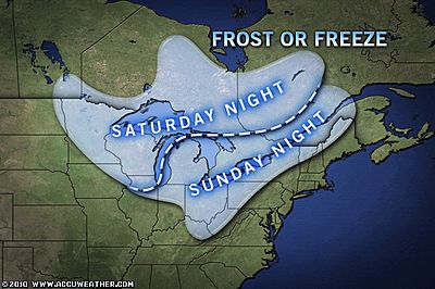
De eerste kou in de V.S.
quote:Cool Blast This Weekend Across Great Lakes, Northeast
Temperatures are expected to plunge this weekend across the Great Lakes and Northeast, delivering the season's first frost for many.
Behind a cold front, cool Canadian high pressure will push south into the Great Lakes on Saturday and across the Northeast later in the weekend.
The cool air combined with changing fall foliage will create the season's first real autumn feeling across areas from the Upper Midwest east across New England this weekend. By early morning, some will even have to deal with frosty windshields with temperatures falling into the 30s.
A widespread frost will blanket parts of northeastern Minnesota, northern Wisconsin and the Upper Peninsula of Michigan Saturday night. Freezing conditions will be possible in the normally cooler areas.
By early Sunday morning, patchy frost will form from across interior Michigan, parts of northwest Pennsylvania, upstate New York and northern New England.
Any remaining, sensitive vegetation should be covered up or brought indoors. Also, be sure to provide adequate, warm shelter for any outdoor pets.
Remember, while the temperature on your household thermometer may read a few degrees above freezing, temperatures at ground-level can often run a few degrees colder, resulting in frost.
As the high pressure builds farther south early next week, temperatures will slowly moderate across the region, but should remain below seasonable levels for at least a few days.
bron
De eerste sneeuw in de bergen
quote:Snow in the East... Already?
Sparky the llama taking a break in the snow. Photo courtesy of Allyson Virden.
Some of the first snow of the season fell Monday, as the high mountains of the Appalachians were coated with several inches of snow.
Allyson Virden, resident manager of the Mt. LeConte, Tenn., lodge, reported 3 inches of snow Monday morning. She said it was the biggest first snow since 1979.
Another half inch of snow fell into Tuesday as the low overnight was 23 degrees.
Mt. LeConte was not the only location with snow. Mt. Mitchell reported a trace of snow Tuesday morning. According to the NWS, the earliest measurable snowfall was on this date back in 1980.
Snowshoe Mountain, W.Va., also reported light snow.
The same storm system that brought clouds, rain and cool weather to the Northeast ushered a cold front farther south into the Appalachians, dropping temperatures throughout the mid-Atlantic.
Cities including Richmond, Charlotte and Nashville have all reported highs significantly below normal over the past several days. High temperatures were running 10 to 15 degrees below the normal high for this time of the year.
For areas including Nashville and Charlotte, the overnight lows are more of what is expected in the middle of November.
Overnight into Tuesday, all three cities had the coldest nighttime temperatures of the season, according to AccuWeather.com Meteorologist Andy Mussoline. For Nashville, it was the coldest weather since April 10.
This cold trend will soon give way to near-normal temperatures by Thursday and will last into the weekend.
AccuWeather.com Winter Forecast for 2010-2011
This year across the United States, AccuWeather.com Chief Long-Range Forecaster Joe Bastardi is predicting harsh cold and snow from the Northwest to the Great Lakes and New England, an early winter for the Northeast, a wintry mess for the mid-Atlantic and Midwest and abnormally warm, dry conditions from Southern California to the Carolinas.
The main player governing the forecast for this winter is the phenomenon called La Nina, when sea surface temperatures across the equatorial central and eastern Pacific are below normal. La Nina strengthens as the departure increases.
La Nina winters are typically synonymous with harsh conditions across the northern tier of the United States and drier-than-normal conditions throughout the southern tier.
Northwest, Plains, Great Lakes and New England Suffer Worst of Winter
Bastardi is pointing to areas from northern New England to the Great Lakes, northern Plains and interior Northwest for the worst of this winter's snow and cold. This zone includes cities from Portland, Maine, to Detroit, Chicago, Minneapolis and Spokane, Wash., with above-normal snow and ice in the forecast.
The good news is that the building of the snowpack across the Pacific Northwest is essential to hydroelectric production in the spring and summer.
While temperatures may average out close to normal in eastern parts of this zone, including Chicago, Detroit and Buffalo, N.Y., these areas will have to endure several outstanding cold shots with larger-than-normal temperature swings.
Bastardi says that January through March will be especially "wicked" for people across the northern Rockies and northern Plains.
Remember that our AccuWeather.com meteorologists will be available to answer any questions you may have about the upcoming winter on our AccuWeather.com Facebook page.
Winter Gets off to an Early Start on the East Coast
Just because the season's worst will stay farther north across the nation this year, this does not mean people along the mid-Atlantic and New England coast will escape winter altogether. Nor'easters that do form will lack moisture from the Gulf of Mexico and, as a result, will not produce the huge quantity of snow seen last season.
Bastardi maintained, "A quick start to winter in the East may have people concerned about another 'snowmageddon', but we expect that much of this winter's snow will come relatively early in the season."
People across the East will also have to deal with winter's chill right off the bat, as temperatures are expected to be near or below normal during most of November and December.
A "Non-Winter" from California to Southeast Does Not Come without Problems
Across the southern tier of the nation from the interior Southwest to the Gulf Coast and Carolinas, Bastardi is calling for a "non-winter" this year with above-normal temperatures and below-normal precipitation. That will be good news for residents of Oklahoma and northern Texas, who may only see a tenth of the near-record snowfall that affected them last season.
Though it sounds nice, this forecast does not come without consequences.
In fact, the overall dry weather pattern expected across the southern tier of the nation could lead the region into a "perilous period" similar to the 1950s and 1960s, which was drier than normal. Drought conditions and water shortages could become major problems from Southern California into the Deep South.
Since Southern California receives most of its yearly rainfall during the winter months, a dry winter will lend to a serious wildfire threat along with water shortages down the road.
The Deep South is already in the midst of a severe drought, and a lack of precipitation this winter will only make matters worse.
This year across the United States, AccuWeather.com Chief Long-Range Forecaster Joe Bastardi is predicting harsh cold and snow from the Northwest to the Great Lakes and New England, an early winter for the Northeast, a wintry mess for the mid-Atlantic and Midwest and abnormally warm, dry conditions from Southern California to the Carolinas.
The main player governing the forecast for this winter is the phenomenon called La Nina, when sea surface temperatures across the equatorial central and eastern Pacific are below normal. La Nina strengthens as the departure increases.
La Nina winters are typically synonymous with harsh conditions across the northern tier of the United States and drier-than-normal conditions throughout the southern tier.
Northwest, Plains, Great Lakes and New England Suffer Worst of Winter
Bastardi is pointing to areas from northern New England to the Great Lakes, northern Plains and interior Northwest for the worst of this winter's snow and cold. This zone includes cities from Portland, Maine, to Detroit, Chicago, Minneapolis and Spokane, Wash., with above-normal snow and ice in the forecast.
The good news is that the building of the snowpack across the Pacific Northwest is essential to hydroelectric production in the spring and summer.

While temperatures may average out close to normal in eastern parts of this zone, including Chicago, Detroit and Buffalo, N.Y., these areas will have to endure several outstanding cold shots with larger-than-normal temperature swings.
Bastardi says that January through March will be especially "wicked" for people across the northern Rockies and northern Plains.
Remember that our AccuWeather.com meteorologists will be available to answer any questions you may have about the upcoming winter on our AccuWeather.com Facebook page.
Winter Gets off to an Early Start on the East Coast
Just because the season's worst will stay farther north across the nation this year, this does not mean people along the mid-Atlantic and New England coast will escape winter altogether. Nor'easters that do form will lack moisture from the Gulf of Mexico and, as a result, will not produce the huge quantity of snow seen last season.
Bastardi maintained, "A quick start to winter in the East may have people concerned about another 'snowmageddon', but we expect that much of this winter's snow will come relatively early in the season."

People across the East will also have to deal with winter's chill right off the bat, as temperatures are expected to be near or below normal during most of November and December.
A "Non-Winter" from California to Southeast Does Not Come without Problems
Across the southern tier of the nation from the interior Southwest to the Gulf Coast and Carolinas, Bastardi is calling for a "non-winter" this year with above-normal temperatures and below-normal precipitation. That will be good news for residents of Oklahoma and northern Texas, who may only see a tenth of the near-record snowfall that affected them last season.
Though it sounds nice, this forecast does not come without consequences.

In fact, the overall dry weather pattern expected across the southern tier of the nation could lead the region into a "perilous period" similar to the 1950s and 1960s, which was drier than normal. Drought conditions and water shortages could become major problems from Southern California into the Deep South.
Since Southern California receives most of its yearly rainfall during the winter months, a dry winter will lend to a serious wildfire threat along with water shortages down the road.
The Deep South is already in the midst of a severe drought, and a lack of precipitation this winter will only make matters worse.
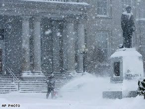
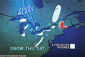
Great Lake effect gaat van zich laten horen. Het gaat sneeuwen rond deze meren.
quote:It is only the first week of November, and we already have a lake-effect snow event set to unfold across the Great Lakes and snow in the forecast for the spine of the Appalachian Mountains the next few days.
The wintry weather is arriving right on time according to the 2010-2011 AccuWeather.com Winter Forecast, which is calling for an early winter in the East and a busy lake-effect snow season for the Great Lakes.
Rain will mix with or change to snow from west to east across the Great Lakes through the end of the week, occurring over northern Michigan today and then areas farther east through New York and Pennsylvania on Friday.
Snow showers will also be found along the spine of the Appalachian Mountains tonight into Friday.
Snow already made an appearance across northern Osceola Co., Mich., on Wednesday morning. No accumulations were reported.
According to the AccuWeather.com Winter Weather Center, places just downwind of the Great Lakes, including Marquette and Gaylord, Mich., South Bend, Ind., Ashtabula, Ohio, Edinboro, Pa., as well as Jamestown, N.Y., have the potential to pick up a few inches of snow by Saturday.
Snowfall totals may even reach half a foot or more in a few locations.
Several inches of snow could also accumulate in the mountains from southwestern Pennsylvania into West Virginia, the Maryland panhandle, western Virginia and even western North Carolina and eastern Tennessee on Friday into Saturday.
While little or no accumulation is expected, the chance for snowflakes is also in the forecast for Detroit, Mich., Albany, N.Y., Pittsburgh and State College, Pa., Charleston, W.Va., and Asheville, N.C., at some point on Friday into Saturday.
Fortunately, this snow event is not expected to have a major, widespread impact on ground travel. Areas at greatest risk for having roads become slippery will be in the higher elevations of the East heading into the weekend.
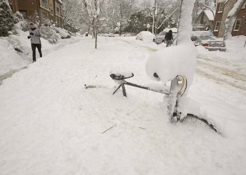
storm en sneeuw in New England'
quote:The first snow of the season greeted people across southern New England this morning with a coating to several inches blanketing areas from Connecticut into Rhode Island and Massachusetts.
In Burrillville, R.I., residents woke up to 2.5 inches of snow on the ground. Other snowfall totals that have been reported include 2.0 inches in Staffordville and Moosup, Conn., 1.5 inches in Greenville, R.I., 0.8 of an inch in Dighton, Mass., and 0.7 of an inch in North Providence, R.I.
Sleet and freezing rain have also mixed in with rain and snow across the region. Sleet was even falling around New York City this morning, while snow fell for a time on eastern Long Island.
In addition to snow and ice, howling winds have been knocking down trees and power lines across much of eastern New England. In Hingham, Mass., people were trapped inside a vehicle after a tree was downed onto it this morning.
Any snow or wintry precipitation that managed to accumulate will be short-lived, as the same storm system that brought the wintry weather soaks the region with plain rain this afternoon into Tuesday.
AccuWeather.com Facebook Fan Erich Twachtman sent in this photo of a tiny snowman after the first snow of the season fell in Haddam, Conn., Monday morning. Twatchman reported wind gusts near 40 mph with the snow. If you have pictures of the snow or have captured other wild weather across the country, be sure to upload your photos on AccuWeather.com's Facebook page.
It will remain raw outside for people across all of New England through Tuesday. Temperatures are expected to remain mostly in the 40s, while howling winds make for a wind-whipped rain from southern New England to the coast of Maine.
AccuWeather.com RealFeel® temperatures, which provide a measure of how cold it feels with the wind factored in, will range between 20 and 30 degrees in Boston, Mass., Hartford, Conn., and Providence, R.I., through tonight.
Warm, waterproof jackets will be more useful than umbrellas as winds whip the rain around.
The storm bringing nasty conditions will pull eastward away from the southern New England coast later Tuesday into Wednesday, allowing for drying from west to east across New England. Warmer air will also spread into the region Wednesday, allowing temperatures to rebound to more seasonable levels.

Ik vind het onbegrijpelijk dat een land dat zich zo met de laatste technologie bezighoudt en er prat opgaat,tav het weer zich zo elke keer laat verrassen. 
Neem al die electriciteitspalen,die altijd boven de grond staan en die altijd voor problemen zorgen bij storm of sneeuw. Waarom plaatst men dat niet zoals in Nl onder de grond dmv kabels ipv die goedkope houten dingen uit de cowboytijd die altijd kapotgaan. Heb je minder last van allerlei weersgevoelige omstandigheden.
Neem al die electriciteitspalen,die altijd boven de grond staan en die altijd voor problemen zorgen bij storm of sneeuw. Waarom plaatst men dat niet zoals in Nl onder de grond dmv kabels ipv die goedkope houten dingen uit de cowboytijd die altijd kapotgaan.
Yvonne schreef op maandag 31 oktober 2011 @
13:59:43 in DEF SC #282 aan AchJa & Co
Vanaf hier en nu stopt het in DEF én op FOK!
Ik wil hier een normale SC zonder gebitch!
13:59:43 in DEF SC #282 aan AchJa & Co
Vanaf hier en nu stopt het in DEF én op FOK!
Ik wil hier een normale SC zonder gebitch!
Lijkt mij gewoon niet te betalen om heel ( of gedeeltelijk ) dat onder de grond te leggen.quote:Op dinsdag 9 november 2010 10:45 schreef rubje het volgende:
Ik vind het onbegrijpelijk dat een land dat zich zo met de laatste technologie bezighoudt en er prat opgaat,tav het weer zich zo elke keer laat verrassen.
Neem al die electriciteitspalen,die altijd boven de grond staan en die altijd voor problemen zorgen bij storm of sneeuw. Waarom plaatst men dat niet zoals in Nl onder de grond dmv kabels ipv die goedkope houten dingen uit de cowboytijd die altijd kapotgaan.

Thanksgiving gaat koud verlopen in grote delen van de V.S. met veel sneeuw , koude temperaturen en verkeerschaos.
Travel Center: Extreme Winter Travel Will Hit Many States This Week

Travel Center: Extreme Winter Travel Will Hit Many States This Week

quote:Messy travel conditions, due to brutal cold, snow, and episodes of wind will remain a big concern in the West early in the week. Meanwhile, more rounds of rain and snow will also shift into the Plains and Great Lakes through much of Thanksgiving week.
The worst of the messy weather will arrive later in the week for areas farther east.
In some parts of the country, the weather can even be dangerous due to the combination of extremely cold temperatures and snow.
The culprits behind the travel problems will be a series of storms that form over the middle of the nation during the early to middle part of next week. Heavy snow will develop on the north side of these systems, while rain and thunderstorms, some potentially severe, break out farther south and east.
Daar sneeuwt het tenminste fatsoenlijk. 
_@/' _@/' _@/' _@/' _@/' _@/' _@/' _@/' _@/' _@/' _@/' _@/' _@/'? '@_
Hier is het elk jaar maar flink duimen op een goede winter, en met een heeeel klein beetje geluk hebben we een witte kerst! 
"Vast sea of artic air"
"brutal cold"


"brutal cold"
Inorbit: zeg dat dan typluie triangeljosti
Beauregard: Een beetje FOK!ker laat het brood door z'n moeder smeren.
Ecosia
ek's 'n flash drive, jy's 'n floppy
Beauregard: Een beetje FOK!ker laat het brood door z'n moeder smeren.
Ecosia
ek's 'n flash drive, jy's 'n floppy

pfff, zou maar een wedstrijd aan de gang zijn zeg...quote:
Forza Scuderia Ferrari
Subaru Power!
Subaru Power!

Leuk om te lezen! Is al weer 17 jaar geleden dat ik dat mocht meemaken, de sneeuwstormen in Virgina/D.C. Wat was dat toen geweldig zeg!
Zonnepanelen 28 * 290 = 8120 Wp - W - 11° hellingshoek
moet je die vent op dat karretje zien scheuren, maakt dat ie wegkomtquote:Op maandag 13 december 2010 10:54 schreef ForzaScuderiaFerrari het volgende:
[..]
pfff, zou maar een wedstrijd aan de gang zijn zeg...
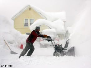
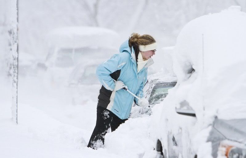
Hevige sneeuwstorm zorgt voor chaos in Midwesten VS
Een hevige sneeuwstorm heeft in het Midwesten van de Verenigde Staten voor verkeerschaos gezorgd. Duizenden vluchten moesten gisteren geschrapt worden en talloze wegen waren onberijdbaar.
In Minneapolis stortte het dak van een sportarena in onder het gewicht van de sneeuw. Bij het incident vielen geen gewonden. Het is al de vierde keer op 30 jaar tijd dat de arena te kampen krijgt met problemen met het dak. Een geplande wedstrijd tussen de Minnesota Vikings en de New York Giants in de nationale Football-League moest verplaatst worden naar Detroit.
In Wisconsin roepen de autoriteiten autobestuurders ondertussen op om enkel in noodgevallen hun wagen te gebruiken. Vooral in Michigan en Wisconsin zou het nog enkele dagen blijven sneeuwen. 's Nachts werden temperaturen tot -25°C gemeten. Ook in Canada wordt er maandag veel sneeuw verwacht. (dpa/svm)
hln

Een hevige sneeuwstorm heeft in het Midwesten van de Verenigde Staten voor verkeerschaos gezorgd. Duizenden vluchten moesten gisteren geschrapt worden en talloze wegen waren onberijdbaar.

In Minneapolis stortte het dak van een sportarena in onder het gewicht van de sneeuw. Bij het incident vielen geen gewonden. Het is al de vierde keer op 30 jaar tijd dat de arena te kampen krijgt met problemen met het dak. Een geplande wedstrijd tussen de Minnesota Vikings en de New York Giants in de nationale Football-League moest verplaatst worden naar Detroit.

In Wisconsin roepen de autoriteiten autobestuurders ondertussen op om enkel in noodgevallen hun wagen te gebruiken. Vooral in Michigan en Wisconsin zou het nog enkele dagen blijven sneeuwen. 's Nachts werden temperaturen tot -25°C gemeten. Ook in Canada wordt er maandag veel sneeuw verwacht. (dpa/svm)

hln
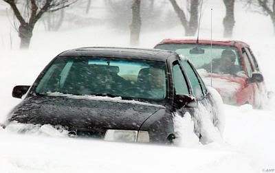
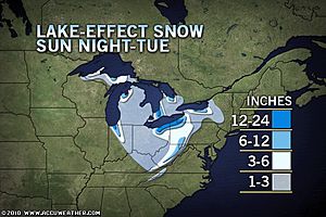
Tremendous Lake-Effect Snow to Follow Blizzard
Tremendous lake-effect snow began thumping behind a blizzard that walloped the Midwest over the weekend. Feet of additional snow will pile up over some communities downwind of the Great Lakes through Tuesday.
The heavy snow will hit the typical snowbelts downwind of the Great Lakes through the central Appalachians hard through Tuesday. Unrelenting frigid winds blowing behind the departing blizzard will create whiteout conditions at times, adding to travel headaches.
Travel will become extremely dangerous along portions of I-90 and other highways and secondary roads throughout the region. This could leave more people stranded on I-90 just a week after a stretch of the interstate closed for nearly 20 hours in hefty lake snow.
The AccuWeather.com Winter Weather Center has a close-up look at the latest snowfall map for the Great Lakes, the interior Northeast, and the Appalachians.
"Places that were missed by the last round of lake-effect snow will get in on the action this time with a more northerly component to the wind," according to AccuWeather.com Meteorologist Justin Povick.
"Cities that will have enough snow to cause travel trouble this time around will include Indianapolis, Cleveland, and Pittsburgh," Povick added.
AccuWeather.com Senior Meteorologist and Global Forecasting Expert Jim Andrews notes that Cleveland could be clobbered by the snow, including at the airport located in the southwestern part of the city.
"There is often a dramatic difference in snowfall amounts from the Cleveland Airport and areas just to the east, which get enhanced snowfall from added lifting of the air over the increasing elevation", according to Andrews.
Snowfall totals are expected to be 4-8 inches in Cleveland. The higher elevations of in northeastern Ohio and northwestern Pennsylvania will get hit by heavier snowfall of 1-2 feet through Tuesday.
Indianapolis will not get as much with 1-3 inches possible. Areas just north and east of the city will get 3-6 inches, while communities just downwind of Lake Michigan in northern Indiana will get a foot or two.
In Pittsburgh, there will be enough snow to plow with totals of 2-4 inches anticipated through Tuesday.
Higher elevations of southwestern Pennsylvania and West Virginia will be another hot spot for snow with up to a foot possible.
In New York, ski areas south of Buffalo will get hit harder than the city, with 4-8 inches of snow forecast. Syracuse will get hit hard by up to a foot of snow and higher drifts. Again, higher elevations could get buried by feet of snow.
Besides causing treacherous travel, the snow is arriving in time to cause disruptions for the work week. School and activity cancellations are likely to impact the hard-hit communities downwind of the Great Lakes.
Keep checking back with AccuWeather.com for the latest lake-effect snowfall forecast.
Accuweather (Video)

Tremendous lake-effect snow began thumping behind a blizzard that walloped the Midwest over the weekend. Feet of additional snow will pile up over some communities downwind of the Great Lakes through Tuesday.
The heavy snow will hit the typical snowbelts downwind of the Great Lakes through the central Appalachians hard through Tuesday. Unrelenting frigid winds blowing behind the departing blizzard will create whiteout conditions at times, adding to travel headaches.
Travel will become extremely dangerous along portions of I-90 and other highways and secondary roads throughout the region. This could leave more people stranded on I-90 just a week after a stretch of the interstate closed for nearly 20 hours in hefty lake snow.
The AccuWeather.com Winter Weather Center has a close-up look at the latest snowfall map for the Great Lakes, the interior Northeast, and the Appalachians.
"Places that were missed by the last round of lake-effect snow will get in on the action this time with a more northerly component to the wind," according to AccuWeather.com Meteorologist Justin Povick.
"Cities that will have enough snow to cause travel trouble this time around will include Indianapolis, Cleveland, and Pittsburgh," Povick added.
AccuWeather.com Senior Meteorologist and Global Forecasting Expert Jim Andrews notes that Cleveland could be clobbered by the snow, including at the airport located in the southwestern part of the city.

"There is often a dramatic difference in snowfall amounts from the Cleveland Airport and areas just to the east, which get enhanced snowfall from added lifting of the air over the increasing elevation", according to Andrews.
Snowfall totals are expected to be 4-8 inches in Cleveland. The higher elevations of in northeastern Ohio and northwestern Pennsylvania will get hit by heavier snowfall of 1-2 feet through Tuesday.
Indianapolis will not get as much with 1-3 inches possible. Areas just north and east of the city will get 3-6 inches, while communities just downwind of Lake Michigan in northern Indiana will get a foot or two.
In Pittsburgh, there will be enough snow to plow with totals of 2-4 inches anticipated through Tuesday.
Higher elevations of southwestern Pennsylvania and West Virginia will be another hot spot for snow with up to a foot possible.
In New York, ski areas south of Buffalo will get hit harder than the city, with 4-8 inches of snow forecast. Syracuse will get hit hard by up to a foot of snow and higher drifts. Again, higher elevations could get buried by feet of snow.
Besides causing treacherous travel, the snow is arriving in time to cause disruptions for the work week. School and activity cancellations are likely to impact the hard-hit communities downwind of the Great Lakes.
Keep checking back with AccuWeather.com for the latest lake-effect snowfall forecast.
Accuweather (Video)
Kijk! Dat zijn nog eens winters! De winter hier stelt niks voor, en alle alarmbellen worden al gerinkeld hierzo. Het word tijd dat Nederland eens een keer zo'n winter krijgt. Alleen maar om te laten zien dat wij hier niet tegen bestand zijn, en dus eigenlijk best wel amateuristisch zijn op het gebied van extreem weer. Amerika weet tenminste wat ze moeten doen in geval van extreem weer... 
Het lijkt nog erger te gaan worden in de VS, men verwacht dat er kouderecords gebroken gaan worden. De kou is tot diep in het zuiden doorgedrongen, zelfs tot Texas (ook Houston en New Orleans hebben temperaturen rond het vriespunt) en delen van Florida.
[ Bericht 1% gewijzigd door #ANONIEM op 13-12-2010 15:24:46 ]
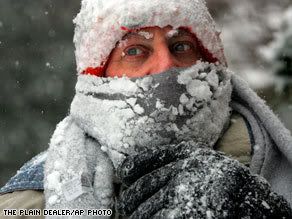
quote:While not everyone across the eastern half of the country dealt with snow or a blizzard this past weekend, they will all be facing brutal cold soon if not already.
The coldest air of the season yet is headed for these regions and could end up being the coldest of the entire winter. Many records, especially nighttime lows across the Southeast, will be broken early this week.
Painfully cold, arctic air sweeping across the Midwest has already been driving temperatures well-below zero. Across much of Minnesota, western Wisconsin and the eastern Dakotas, lows were down to 10 to 20 degrees below zero this morning.
Today, the bitter cold is overspreading the rest of the eastern half of the country. While actual temperatures may not fall below zero early this week, horrendous winds will make it feel that way for millions.

quote:AccuWeather.com RealFeel® temperatures, which provide a measure of how cold it feels with the wind factored in, have already dropped below zero as far south as Atlanta this morning. Early Tuesday and Wednesday morning, these values will be near zero all the way east into New York City and Philadelphia and stay in the single digits all day Tuesday.
In Chicago, Detroit, Minneapolis, Indianapolis and Pittsburgh, people will have to endure RealFeel® temperatures that stay below zero for 36 to 48 hours straight. Frostbite and hypothermia can set in very quickly in such extreme cold.
Since many of these places have picked up snow from the blizzard this weekend, roads are in tough shape. Any travelers who end up being stranded could find themselves in a life-threatening situation if left too long in the brutal cold.
Farther south across the country, temperatures have dropped into the teens and even single digits this morning from Oklahoma to Tennessee and the eastern Great Lakes. Even northern portions of Mississippi, Alabama and Georgia have dipped into the teens.
Meanwhile, subfreezing temperatures have reached all the way into Deep South Texas, central Florida and many areas along the Gulf Coast, including areas around Houston, New Orleans, Gulfport, Miss., Mobile, Ala., and Panama City, Fla.

quote:Tonight will be even colder for most of the Southeast with widespread lows in the teens extending into southern parts of Mississippi, Alabama and Georgia and even into northern Florida.
The cold will put additional stress on winter crops across the Southeast and especially in Florida. Damage was already done during last week's freeze.
[ Bericht 1% gewijzigd door #ANONIEM op 13-12-2010 15:24:46 ]

Ik weet niet of dat nou zo'n goed idee is.quote:
Het word tijd dat Nederland eens een keer zo'n winter krijgt.
Patience is not one of my virtues, neither is memory. Or patience for that matter.