WKN Weer, Klimaat en Natuurrampen
Lees alles over het onstuimige weer op onze planeet, volg orkanen en tornado's, zie hoe vulkanen uitbarsten en hoe Moeder Aarde beeft bij een aardbeving. Alles over de verwoestende kracht van onze planeet en tal van andere natuurverschijnselen.


had het net gepost in het orkanentopic. Tis niet 100% zeker of het photoshop is of nietquote:Op dinsdag 1 juni 2010 00:31 schreef Burner82 het volgende:
Gebeuren nog meer rare dingen in guatamala....
http://edition.cnn.com/20(...)cy/index.html?hpt=T1
ik geloof dat ik volgende maand dat gat ga zien.., geloof nooit dat ze het voor die tijd dicht hebben...quote:Op dinsdag 1 juni 2010 00:31 schreef Burner82 het volgende:
Gebeuren nog meer rare dingen in guatamala....
http://edition.cnn.com/20(...)cy/index.html?hpt=T1
nö, is echt, is erg in de buurt van een studiegenoot van mn meisjequote:Op dinsdag 1 juni 2010 16:37 schreef Frutsel het volgende:
[..]
had het net gepost in het orkanentopic. Tis niet 100% zeker of het photoshop is of niet
quote:Op dinsdag 1 juni 2010 17:02 schreef woid het volgende:
[..]
nö, is echt, is erg in de buurt van een studiegenoot van mn meisje


http://en.wikipedia.org/wiki/Taal_Volcanoquote:Alert level 2 raised at Taal volcano
By Arnell Ozaeta and Helen Flores (The Philippine Star) Updated June 09, 2010 12:00 AM
Batangas, Philippines – The Philippine Institute of Volcanology and Seismology (Phivolcs) has raised the alert level at Taal volcano from 1 to 2 due to the increasing frequency of volcanic earthquakes in the area.
Taal, located 65 kilometers south of Manila, is one of the most unstable of the country’s 22 known active volcanoes with 33 recorded eruptions, the last one in 1977.
Experts raised the second of a five-level alert on Taal yesterday. The Phivolcs said volcanic quakes in the area have been occurring since April and the crater lake was heating up.
Allan Loza, officer-in-charge of Phivolcs Talisay said based on their monitoring, the volcanic earthquakes detected per day since April 26 have raised to 32 high frequency volcanic earthquakes and continuously increasing as of presstime.
Subsequently, the Phivolcs immediately released an advisory preventing the public to visit the crater area of Taal, specifically the Daang Kastila trail.
In addition, a low frequency type volcanic earthquake was also detected since June 2.
Meanwhile, the Regional Disaster Coordinating Council (RDCC) in Calabarzon (Cavite, Laguna, Batangas, Rizal, Quezon) said it had alerted nine Batangas towns after the alert level status of Taal volcano was raised to level 2 on Tuesday.
“We have advised our Batangas Provincial Disaster Coordinating Council (PDCC) to issue a memorandum to all concerned municipalities regarding the alert level 2,” said RDCC director Vicente Tomazar.
The nine towns in Batangas province include Agoncillo, San Nicolas, Santa Teresita, Laurel, Lemery, Talisay, Tanauan City, Balete, and Mataas na Kahoy.
Officials of the tourist city of Tagaytay in Cavite, from which Taal volcano is also viewed, were also alerted to prohibit its tourists from trekking to the crater which is considered to be a danger zone.
Tomazar said if the alert level status hits level 3 under continuous monitoring, that is the time the authorities would activate its contingency plan and enforce evacuation of residents.
Phivolcs said the temperature measurement of the main crater of the lake had increased to 34°C as of May 24, higher by 2°C from the previous measurement on May 11.

oh, dat gaat weer spannend voor manilla worden...
Inorbit: zeg dat dan typluie triangeljosti
Beauregard: Een beetje FOK!ker laat het brood door z'n moeder smeren.
Ecosia
ek's 'n flash drive, jy's 'n floppy
Beauregard: Een beetje FOK!ker laat het brood door z'n moeder smeren.
Ecosia
ek's 'n flash drive, jy's 'n floppy
Oh, die is niet fijn, volgens wiki, 30 bekende uitbarstingen, veel slachtoffers, sinds 1977 niet meer uitgebarsten maar in 1991 wel aan het rommelen geweestquote:Op woensdag 9 juni 2010 13:49 schreef Frutsel het volgende:
[ afbeelding ]
[..]
http://en.wikipedia.org/wiki/Taal_Volcano
Wederom wel weer een fotogenieke berg:

be nice or go away
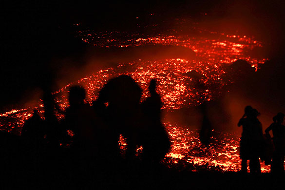
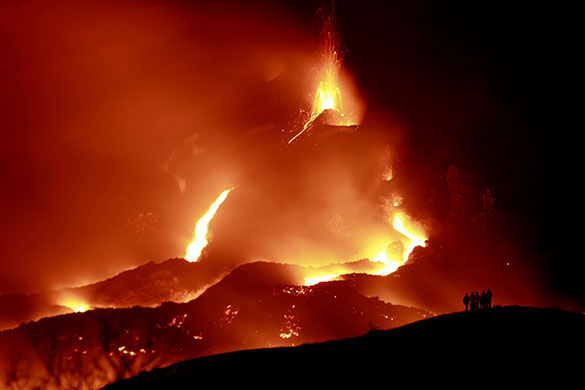
Ondanks dat er heel veel toeristen een kijkje gaan nemen is het op mount Pacaya nog niet veilig, de experts waarschuwen dan ook niet te dicht bij de lava te komen.
De vulkaan staat nog steeds onder observatie:
De vulkaan staat nog steeds onder observatie:
quote:LOS POCITOS, Guatemala — Thousands of tourists are flocking to Guatemala's Pacaya volcano to see the glowing rivers of lava cascading down its slopes, worrying officials who say they're risking their lives two weeks after a deadly eruption.
Pacaya National Park was closed even before the May 27 explosion, which killed a reporter who got too close and was hit by a shower of volcanic rock. But visitors are bypassing the usual route up the mountain and going instead to a private farm in the village of Los Pocitos, where locals will take them to the pyroclastic flows for a $1.25 a head.
"Just this weekend 2,000 people or more came by," said Lourdes Barillas, who oversees the collection of funds — intended to help rebuild the hundreds of homes destroyed by the eruption.
The lava puts on a particularly incandescent show at night, attracting both foreign and Guatemalan tourists who say they feel safe because hundreds are still living nearby. Some throw sticks or plantain leaves into the lava to watch them catch fire instantly.
"Before, I was worried," Canadian traveler Alexandre Cagne said. "But now I'm calm. It doesn't look like something violent that can explode."
"I'm not scared because we came with a guide who has 18 years of experience," Spanish tourist Ana Villen added.
Emergency officials say the danger is real, and are asking guides not to take people up the mountain.
"This is dangerous," David de Leon, emergency response spokesman, said Monday.
Francisco Valdez, a geophysicist with Guatemala's Institute of Seismology and Volcanos who has studied the volcano, said it is best not to get too close to the lava.
But if Pacaya erupts again it is most likely to do so gradually, he said, adding that a rain of lava and rock is out of character with its usual behavior.
be nice or go away
Met kijkersfile zo te zien aan de foto'squote:
Dare to unleash my rage..
That's my secret Captain... I'm always angry...
There's nothing like a trail of blood, to find your way back home.
That's my secret Captain... I'm always angry...
There's nothing like a trail of blood, to find your way back home.
23 bevinkjes bij de Taal afgelopen 24 uur las ik net... blijft rommelen... voorlopig level 2 

afhankelijk van de kracht en de wind best veel hoorquote:
Wat blijft er trouwens van Nederland over als Laacher See actief wordt ?
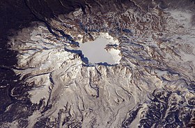
Baekdu Wikipediaquote:Mt Baekdu eruption in next few years
The April 14 eruption of the Eyjafjallajokull volcano in Iceland sent volcanic ash clouds flying on currents and blanketing European skies. For five days after the eruption, 313 airports were shut down and 82,000 flights were canceled, causing a major disruption in air transportation. The online edition of the U.S. diplomatic journal Foreign Policy has named Merapi in Indonesia, Nyiragongo in the Democratic Republic of Congo, Yellowstone in the U.S., Santa Maria in Guatemala, and Avachinsky in Russia as volcanoes “ready to blow.”
Experts say Mount Baekdu in North Korea, which is classified as a dormant volcano, will see a major eruption in four to five years. This news spread like mythical rumors among Chinese volcanologists and was raised for discussion for the first time at a seminar hosted by the (South) Korea Meteorological Administration Wednesday. At the seminar “Volcanic Crisis on Mount Baekdu and Response,” earth science professor Yoon Seong-hyo of Busan National University said seismic activity on Mount Baekdu has surged to 240 times per month. He said the topography of the areas surrounding the mountain is rising, while trees are dying due to volcanic gas. These signs all herald volcanic activity.
The volcano in Iceland had a volcanic explosivity index of four, and the volcanic ash was just 0.11 cubic kilometers. Nevertheless, it brought the European aviation network to a standstill and caused massive damage to the world economy. According to scholars, when the Mount Baekdu volcano had a massive eruption in the mid-10th century, the volume of ash was 100 cubic kilometers and the volcanic explosivity index was 7.4. The eruption was reportedly one of the largest in human history. Given the magnitude of damage caused by the Iceland volcano, which generated ash clouds 1/1000th the volume of Mount Baekdu’s in the 10th century, it is difficult to even imagine the scale of damage that an eruption of the Mount Baekdu volcano could inflict.
A volcanic eruption can shift the flow of human civilization. Examples include Mount Vesuvius, which destroyed the ancient Roman city of Pompeii; Kikai Caldera, which destroyed the Neolithic civilization in Japan; and Laki in Iceland, which caused starvation that triggered the French Revolution when it erupted between 1783 and 1784. One academic theory suggests that the massive eruption of the Mount Baekdu volcano led to the collapse of the ancient Korean kingdom of Balhae. Amid mounting fears among the general public, the weather agency in Seoul has started preparation at the national level. Since Mount Baekdu is not under the country’s sovereignty, South Korea could face limits in its capacity to predict volcanic activity on the Korean Peninsula’s tallest mountain. People should not panic despite increased fears over a natural disaster, however, a phenomenon humans can do little about.
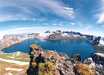
Ook al weer zo'n mooie vulkaan.quote:Op maandag 21 juni 2010 11:51 schreef Frutsel het volgende:
[ afbeelding ]
[ afbeelding ]
[..]
Baekdu Wikipedia
Ook maar ff volgen dus.
16!quote:
be nice or go away
quote:Kamchatka volcano threatens air traffic
The Shiveluch volcano on the Russian Kamchatka Peninsula has erupted, producing an ash plume of 6.5 kilometers. Nearby towns are outside the so-called danger zone.
The alert status at Shiveluch was declared “orange”, which means that eruption is in progress and the volcano’s activity may pose a threat to the aircraft.
At the same time, seismologists have reported weak ash bursts from the neighboring Klyuchevskaya Sopka Volcano.
quote:Calamity declared in towns around Taal volcano
Filipino disaster officials have declared a state of calamity in a dozen cities and towns near Taal volcano.
The declaration in the province of Batangas allows local officials to release part of a 2.3- million peso ($50,000) calamity fund to the affected areas.
Alert level two remains in effect for Taal, which lies 30 miles south of the capital of Manila. No mandatory evacuations have been imposed but nearly 700 people have left their homes to stay in evacuation centers or with relatives.
Disaster officials have also prepared contingency plans for residents and tourists in Tagaytay, a city that lies on the rim of the volcano's outer crater.
The Philippine National Red Cross says it has six teams prepared to deploy in the event of an eruption.
A level two alert means that magma is moving towards the surface of the volcano, an activity that could lead to an eruption. It took effect early this month, although Taal has been restive since 1991. Alert level one was raised last year when the volcano began spewing bubbles and white steam.
Taal has an outer crater that holds an 18-mile wide lake created long ago during a massive eruption. The lake contains an island, called Volcano Island, which also has a crater lake.
Hiking on Volcano Island and boat rides to the smaller crater lake are popular activities in Tagaytay, which is a weekend and day trip destination for many in Manila because of its mild climate and rustic cottages.

quote:Russian volcano eruption continues
Russia’s northernmost active volcano on Kamchatka Peninsula is spewing plumes of ash at a height of more than 6 kilometers, the local branch of the National Geophysical Service reported on Sunday.
The 3,300m Mt. Shiveluch has been erupting for many days now with 80 underground temblors registered in the past 24 hours alone.
Scientists say the volcano poses significant danger to villages in the area, just like the nearby Klyuchevskaya volcano.
quote:Huge underwater volcano found in Indonesia
A U.S.-Indonesian underwater exploration project has found a giant volcano on the ocean floor north of Sulawesi, Indonesia.
“This is a huge undersea volcano, taller than all but three or four mountains in Indonesia,” Jim Holden, the U.S. chief scientist of the expedition, said in a news release issued Monday by the U.S. National Oceanic and Atmospheric Administration.
The volcano rises more than 3,000 metres from the sea floor, which is about 5,500 metres deep at that point.
The NOAA ship Okeanos Explorer mapped the volcano using its sonar. The ship's underwater robot, Little Hercules, took pictures of the feature, known as Kawio Barat.
The project is a new way of exploring the ocean floor, because most of the scientists are on shore at command centres in Jakarta and Seattle, connected to the ship by satellite and high-speed internet, NOAA said.
When Little Hercules turns on its the lights and high-definition video cameras, "it’s live from the sea floor to scientists ashore,” said Holden, who's in Jakarta.
The researchers hope to find new phenomena and information about ocean ecosystems, acidification and climate change by investigating previously unexplored areas.
So far, Okeanos Explorer has mapped about 620,000 hectares of the Indonesian sea floor. With an Indonesian research vessel, the expedition will continue until Aug. 14.
The volcano is located west of Indonesia's Kawio Islands, which are between Indonesia and the Philippines
wow, we weten eigenlijk nog zo weinig over de onderwaterwereld
DeLuna vindt me dik ;(
Op zondag 22 juni 2014 12:30 schreef 3rdRock het volgende:
pas als jullie gaan trouwen. nu ben je gewoon die Oom Rubber die met onze mama leuke dingen doet :)
Op zondag 22 juni 2014 12:30 schreef 3rdRock het volgende:
pas als jullie gaan trouwen. nu ben je gewoon die Oom Rubber die met onze mama leuke dingen doet :)
Wow, een 3 km hoge berg die 2.5 km onder de zeespiegel zit.....  Zou die berg nu ook een eigen mini eco systeem hebben? We weten idd heel weinig over de zeebodem. Ironisch genoeg weten we meer over de melkweg....
Er is trouwens activiteit gemeten in een oude bekende vulkaan:
http://www.wowbatangas.co(...)pinestaalvolcano.jpg
Er is trouwens activiteit gemeten in een oude bekende vulkaan:
http://www.volcanolive.com/news.htmlquote:Tuesday 8th June 2010
Taal volcano, Philippines
Taal volcano in the Philippines has been showing signs of unrest. Since 26th April volcanic earthquakes have increased. Between 11-24 May the temperature in the crater lake increased by 2-3 dec C. The composition of Main Crater Lake water has shown above normal values of Mg/Cl, SO4/Cl and Total Dissolved Solids. There has been ground steaming accompanied by hissing sounds on the northern and northeast sides of the main crater. PHIVOLCS has raised the status of the volcano to Alert Level 2, which indicates the volcano is undergoing magmatic intrusion which may lead to an eruption. The main crater has been placed off limits due to the risk of an eruption.
http://www.wowbatangas.co(...)pinestaalvolcano.jpg
be nice or go away
Vorjog jaar hadden we plannen op naar de Taalvulkaan te gaan. Helaas door de vele orkanen toch maar niet gedaan 
Inorbit: zeg dat dan typluie triangeljosti
Beauregard: Een beetje FOK!ker laat het brood door z'n moeder smeren.
Ecosia
ek's 'n flash drive, jy's 'n floppy
Beauregard: Een beetje FOK!ker laat het brood door z'n moeder smeren.
Ecosia
ek's 'n flash drive, jy's 'n floppy