WKN Weer, Klimaat en Natuurrampen
Lees alles over het onstuimige weer op onze planeet, volg orkanen en tornado's, zie hoe vulkanen uitbarsten en hoe Moeder Aarde beeft bij een aardbeving. Alles over de verwoestende kracht van onze planeet en tal van andere natuurverschijnselen.


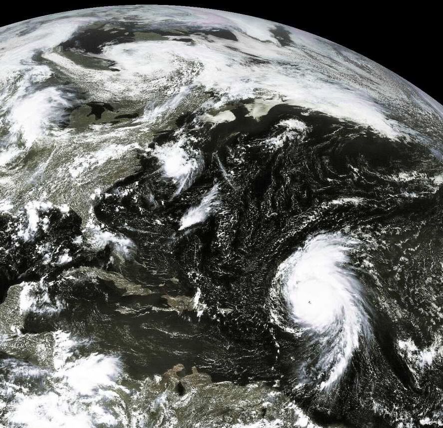
Bill's big wavesquote:
Large swells from Bill will begin impacting the U.S. East coast from Florida to Maine beginning Friday night or Saturday morning. Seas will build to 5 - 10 feet in the offshore waters from central Florida northwards to South Carolina, and to 10 - 15 feet from North Carolina to Cape Cod. Near shore, waves will be about 40% less. This will cause a significant coastal erosion event along some portions of the coast. The latest run of the NOAA Wavewatch III model suggests that significant wave heights near Bill's center will reach 50 feet on Sunday. Since maximum wave height is typically about a factor of 1.9 greater than the significant wave height (which is the average trough-to-crest height of the top 1/3 largest waves), a few huge waves near Bill's center may reach 95 feet high.

95 feet is bijna 30 meterquote:Op woensdag 19 augustus 2009 23:28 schreef Co_OL het volgende:
[..]
Bill's big waves
Large swells from Bill will begin impacting the U.S. East coast from Florida to Maine beginning Friday night or Saturday morning. Seas will build to 5 - 10 feet in the offshore waters from central Florida northwards to South Carolina, and to 10 - 15 feet from North Carolina to Cape Cod. Near shore, waves will be about 40% less. This will cause a significant coastal erosion event along some portions of the coast. The latest run of the NOAA Wavewatch III model suggests that significant wave heights near Bill's center will reach 50 feet on Sunday. Since maximum wave height is typically about a factor of 1.9 greater than the significant wave height (which is the average trough-to-crest height of the top 1/3 largest waves), a few huge waves near Bill's center may reach 95 feet high.
en dat van alleen wind, geen aardbeving of zo. Gelukkig hebben ze dan ook niet de diepgang van een tsunami, want dan zou het een echte ravage worden.quote:
Bill inmiddels gedowngrade naar Cat.3 lees ik net
quote:BILL FORECAST TO MAKE LANDFALL IN NOVA SCOTIA AFTER PASSING FAIRLY CLOSE TO NEW ENGLAND- BUT HOW CLOSE?
There is not a lot of new info tonight, nothing unexpected, concerning Bill. The latest forecast brings the hurricane inland over Nova Scotia Sunday and then Newfoundland on Monday. This would likely be a very bad event for them as Bill will pass over very warm water even as it turns north in a couple of days. People in the Canadian Maritimes need to begin thinking about their hurricane preparedness plans now. This has the potential of being a severe event for that region.
First Bill must pass Bermuda and should do so to the west- hopefully enough so that the worst effects are kept over the ocean. From there, it all depends on how far north and west Bill tracks before fading east towards the Maritimes. Only a small portion of New England is within the cone of uncertainty now which is good news. I think we have about 48 more hours until we will know whether or not New England will have to deal with hurricane conditions or just a breezy day. One thing is certain, large and dangerous waves are heading for land. Surfers will like this but everyone should be very careful out there. Please be sure to monitor your LOCAL beach conditions- when in doubt, ask a lifeguard or call your local NWS office. I'll have more here tomorrow morning and will decide at that point whether or not we will be taking a trip to Cape Cod for a meeting with Bill this weekend
Als Bill bij Nova Scotia aankomt is het ws een tropische storm geworden... Zal wel mee gaan vallen dus  Maarrrr hoe zit het met Bermuda?
Bermuda krijgt, aldus de laatste berichten, niet de volle laag, maar zeker wel enkele uitwassen van de storm. Laat staan, metershoge golven 
Ik denk dat een gedeelte van de Oostkust van de U.S. ook het nodige gaat mee krijgen. New York etc...daar gaat ie bijna net zo rakelings langs als langs Bermuda.quote:Op donderdag 20 augustus 2009 11:16 schreef Frutsel het volgende:
Bermuda krijgt, aldus de laatste berichten, niet de volle laag, maar zeker wel enkele uitwassen van de storm. Laat staan, metershoge golven
Mwah... manhattan zit vast te wachten op golfjes van 30 mquote:Op donderdag 20 augustus 2009 11:40 schreef aloa het volgende:
[..]
Ik denk dat een gedeelte van de Oostkust van de U.S. ook het nodige gaat mee krijgen. New York etc...daar gaat ie bijna net zo rakelings langs als langs Bermuda.
lijkt me vrij nihili die kansquote:
Zou het nog kunnen dat Bill zich bedenkt en alsnog over de golf van mexico gaat?
Ik hoop op het nieuwe onweersfront boven Afrika.. Bill is wel een gave orkaan, maar de trekrichting is gewoon jammer. Misschien krijgen wij over een week of 2 nog wel een laatste vleugje van Bill mee in Europa.
's Avonds een man, overdags rustig an
quote:Bill's waves
Hurricane Bill is generating huge waves, thanks to its enormous size and major hurricane intensity. Bill passed about 75 miles southwest of Buoy 41044 this morning, and the buoy recorded sustained winds of 67 mph, gusting to 92 mph, with a significant wave height (the height of the average 1/3 highest waves) of 38.8 feet. Output from NOAA's Wavewatch III model suggests that significant wave heights near Bill's center will peak at 50 feet by Saturday. Large swells from Bill will reach Bermuda this afternoon, increasing seas to 5 - 9 feet, according to the Bermuda Weather Service. Seas will increase to 10 - 20 feet on Friday and 20 - 30 feet on Saturday as Bill makes its closest approach to the island.
In the U.S., Bill's swells will reach New York's Long Island on Friday afternoon, and seas will build to 7 - 10' on Saturday and 12 - 16' on Sunday in the near shore waters. By Friday night, Bill's swells will be affecting the entire U.S. East Coast from Florida to Cape Cod. Maximum sea heights in near shore waters over the weekend will be about 7' from Florida to South Carolina, 11 - 14' along the North Carolina coast, 8 - 11' along the mid-Atlantic coast, and 10 - 11' along the coast of Maine. The highest waves along the U.S. coast will occur at Cape Cod, Massachusetts, where waves of 18 - 23' are being forecast by NOAA for Sunday. Bill's high waves are going to cause millions of dollars in erosion damage and create very dangerous rip currents and swimming conditions along the coast.
quote:AMAZING FORECAST FOR BILL SO FAR BUT THE EFFECTS WILL BE WIDESPREAD
The NHC has done quite an incredible job with the forecast for Bill. It has not pulled any suprises and seems to be following pretty much what was predicted by the folks in Miami. The hope is, obviously, that this will continue and Bill will not have the kind of impact that it is capable of. None the less, [b]the effects from Bill will be felt far and wide and I am not kidding about this.
Huge waves will impact Bermuda soon followed by a great deal of the Atlantic side of North America. In some place that typically have erosion problems, ocean overwash is coming. Houses and other structures already too close to the water will be in even more peril. All of this without the hurricane making a direct hit. It is that kind of hurricane that we are dealing with. For folks in Bermuda, Bill will pass well to the west but its huge size will still spread rain and wind with flooding storm surge-like wave action. I have not seen an Atlantic hurricane like this in a long time.
Once past the latitude of Bermuda, Bill should start to turn more northward and then east of north. When this happens is so critical to what effects are felt in New England and the Canadian Maritimes. So far, the NHC track has remained well offshore of New England but even there, large waves will do damage to the coastline.
Bill is een rare orkaan... Als hij landfall maakt in Nova Scotia is het nog steeds een categorie 1 als ik het goed zie. Is er ooit wel eens een orkaan categorie 1 in Canada geweest? En wij krijgen volgende week donderdag en vrijdag ook rotweer, zelfs als hij in Ierland / Noord Engeland aan land komt schijnt het nog een (sub)tropische storm te zijn!
Jep, Hurricane Kyle vorig jaar nogquote:
Bill is een rare orkaan... Als hij landfall maakt in Nova Scotia is het nog steeds een categorie 1 als ik het goed zie. Is er ooit wel eens een orkaan categorie 1 in Canada geweest? En wij krijgen volgende week donderdag en vrijdag ook rotweer, zelfs als hij in Ierland / Noord Engeland aan land komt schijnt het nog een (sub)tropische storm te zijn!
40.000 huishoudens zonder stroom, 10 miljoen dollar schade
Hurricane Kyle
quote:Orkaan Bill in Canada
MIAMI - De orkaan Bill heeft maandagochtend de kust van de provincie Newfoundland in het uiterste oosten van Canada bereikt. Dat heeft het Amerikaanse orkanencentrum in Miami gemeld. De stormwind trekt nu over het zuidoostelijke deel van Newfoundland
De golven die met de hevige wind gepaard gingen, hebben in de staat Maine in het noordoosten van de Verenigde Staten een meisje van 7 jaar het leven gekost. President Barack Obama stelde zondag zijn vakantie op het eiland Martha's Vineyard voor de Amerikaanse oostkust enkele uren uit, totdat de orkaan was voorbijgetrokken.
Bill is de eerste Atlantische orkaan van dit jaar. De wervelstorm valt in categorie 1 van de zogeheten Saffir-Simpsonschaal, die wordt gebruikt om de kracht van orkanen te meten. Dat betekent dat de orkaan zwak is en lichte schade aanricht. Vorige week was Bill nog een orkaan van de vierde categorie, het op een na hoogste niveau.
Gaat Bill de hele tocht terug over de Atlantic overleven als Tropische storm?
Dan gaan we d'r vast nog iets van meekrijgen? Ierland in elk geval

quote:NOW THAT BILL IS GONE, WHAT'S NEXT?
The NHC is no longer issuing advisories on Bill as the system has transformed in to a non-tropical type of ocean storm. The one-time category four hurricane certainly left its mark throughout the western Atlantic Basin and will be remembered for a while to come I am sure. So what's next?
It is still only late August and we have a lot of hurricane season left to deal with. In fact, there is likely more activity brewing now that could impact the weekend ahead. A large area of clouds, showers and thunderstorms is slowly organizing a few hundred miles east of the Lesser Antilles. This is associated with a tropical wave that flared up several days ago and then died off.
Now that Bill has cleared the pattern, the tropics are conducive for development again. A look at the usual global computer models suggests that we will see the development of a tropical depression somewhere near the Bahamas in about 72 hours- maybe less. None of the models show the system getting very strong which is good news.
As is always the case, we'll just have to watch and see how things unfold with the upper air pattern and steering currents. I would say it is a safe bet that unsettled weather will be the rule in the SW Atlantic by mid-week. Water temps in the region are very warm and mostly undisturbed so there is potential for tropical cyclone formation in this region. Also of note, the GFS, which handled the genesis of Bill to near perfection, is showing another Cape Verde system getting organized over the next 3-5 days. Other models are not as aggressive as the GFS but its run to run consistency is picking up a little.
We would expect to see development just about anywhere in the Atlantic at this point so it is nothing to be alarmed about. We remain in an active pulse period with favorable conditions in many areas. Just keep aware of the latest goings on and we'll keep posting new info as it comes in
quote:Dodental in Taiwan blijft oplopen
TAIPEI - De tyfoon Morakot, die Taiwan eerder deze maand trof, heeft inmiddels aan 376 mensen het leven gekost. Meer dan 250 mensen worden nog altijd vermist. Dat heeft de Taiwanese regering dinsdag gezegd.
Maandag ging Taiwan nog uit van 292 doden en bijna vierhonderd vermisten. Bijna alle slachtoffers komen uit het zuidelijke dorp Hsiaolin, dat tijdens het noodweer werd bedolven onder een modderstroom.
Op de puinhopen zal een herdenkingspark worden aangelegd. Het dorp zelf zal niet worden opgegraven, maakte de burgemeester maandag bekend.

