WKN Weer, Klimaat en Natuurrampen
Lees alles over het onstuimige weer op onze planeet, volg orkanen en tornado's, zie hoe vulkanen uitbarsten en hoe Moeder Aarde beeft bij een aardbeving. Alles over de verwoestende kracht van onze planeet en tal van andere natuurverschijnselen.


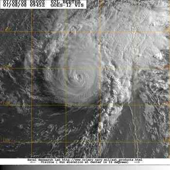
Bertha is een categorie3 geworden.
"Major" Hurricane Bertha
Hurricane Bertha (120 mph) intensified rapidly on Monday.
Bertha, as of 5 a.m. EDT, was centered about 1035 miles SE of Bermuda and moving toward the NW at 10 mph.
The hurricane may grow in size as it moves to higher latitudes.
It still appears as if Bertha will eventually take a more northerly course and miss the East Coast of the U.S. Bermuda, however, could be threatened. Residents of the island are advised to pay close attention to the hurricane's progress.
Wow. Dat was nou niet echt voorzien, geloof ik. Bewijst maar weer dat we nog geen donder van die dingen snappen.
Two named storms
Category 1 Hurricane Bertha (winds of 80 mph) is centered about 215 miles southeast of Bermuda, creeping northward at around 2 miles per hour. This very slow movement will continue into Monday. Then Bertha's track should gradually veer northeastward and then eastward with steady weakening.
Bermuda is experiencing high surf on the order of 16 to 22 feet along south and southeast facing beaches. Increased surf is also impacting the East Coast of the United States, especially now from the Outer Banks northward, with 3 to 7 foot waves. Dangerous rip currents are also occurring.
In the eastern Pacific, Tropical Storm Elida has formed, located 270 miles south-southeast of Acapulco, Mexico. It is currently moving west northwest, away for the western Mexico Coast; little impact to land is expected.
An area of low pressure was also located about 200 miles south of Cabo San Lucas, Mexico. It is possible this could develop into a tropical depression, as it moves slowly off to the west.

Bertha weakened from a hurricane to a tropical storm Sunday as it hovered near Bermuda. Forecasters say it might still deal a glancing blow to the Atlantic island.
Bertha's outer bands were expected to brush the island in the coming days.
Over the weekend, most tourists chose to hang out in pools and walk along the beach instead of battle the storm-whipped surf and rip currents along Bermuda's southern coast. Signs were posted announcing that beaches are closed.
"You can go out and swim if you like, but lifeguards will not come out and get you," said Darnell Joell, a bartender at Coco Reef resort.
Lifeguards at Horseshoe Beach blocked the shoreline with bright red tape and turned tourists away. Many lingered, however, taking pictures of the crashing waves.
The U.S. National Hurricane Center said the storm's maximum sustained winds decreased to near 65 miles per hour. Bertha was centered about about 180 miles southeast of Bermuda.
The center said Bertha was moving northwest at about 2 miles per hour. The center of the storm is expected to pass slowly not far to the southeast and east of Bermuda, dumping 2-4 inches of rain on the island. The center's hurricane tracking map showed Bertha sideswiping Bermuda on Monday, a day later than earlier forecasts.
Many tourists were largely unconcerned.
"It's not really going to hit that hard," said Eilif Kenny, 21, who was visiting from Ireland. "If it was ... I'd be under the bed."
Bertha became the Atlantic season's first hurricane on July 7 and has vacillated between a Category 1 and 2 storm.
Meanwhile, Tropical Storm Elida swirled off Mexico's Pacific coast, about 250 miles southwest of Acapulco.
The hurricane center said Elida was headed farther out to sea. It had sustained winds of nearly 65 mph on Sunday morning and was traveling west-northwest at 16 mph.
cnn

Hurricane Bertha
Tropical Storm Bertha swept past Bermuda on July 14, 2008. The storm system had fallen from hurricane strength, but it still packed winds of 100 kilometers per hour (55 miles per hour) around the storm center. The island of Bermuda is no stranger to severe storms, and had battened down in preparation. There were widespread power outages, but no serious damage or injuries were reported, according to the Associated Press on July 15. Rip tides and surf were unusually strong not only in Bermuda, but along much of the east coast of the United States, due to the winds and waves from the storm system.
This natural-color satellite image, obtained by the Moderate Resolution Imaging Spectroradiometer (MODIS) on NASA’s Terra satellite shows Tropical Storm Bertha as it appeared at 12:05 p.m. local time (15:05 UTC) on July 14, 2008. The storm system shows the hallmark spiral shape of a tropical storm system and remnants of a central eye, but its appearance was more ragged than a well-formed hurricane. As of July 15, forecasters at the National Hurricane Center were anticipating that the storm system would move away from Bermuda and rebuild in strength slightly to reach Category 1 hurricane status once again.
Momenteel zijn er 4 systemen aktief, waarvan Tropical cyclone KALMAEGI het meeste gevaar oplevert.
Kans is groot dat er zich eerdaags weer een storm in de Atlantische Oceaan ontwikkeld.
Kans is groot dat er zich eerdaags weer een storm in de Atlantische Oceaan ontwikkeld.
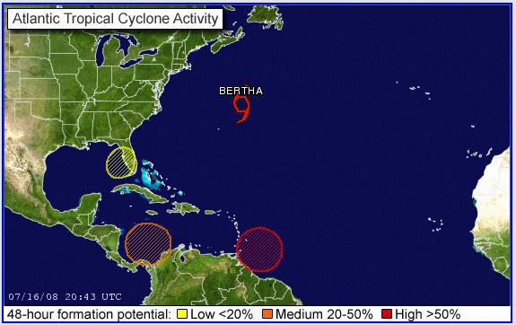
Ligt het aan mij of lijkt het ook ten zuiden van Cuba en zuidwesten van de Dominicaanse republiek te broeien?
Het kon inderdaad weleens druk gaan worden in de Caribbean.quote:Op donderdag 17 juli 2008 09:48 schreef Frutsel het volgende:
[ afbeelding ]
Ligt het aan mij of lijkt het ook ten zuiden van Cuba en zuidwesten van de Dominicaanse republiek te broeien?

Fausto en Elida gaan langs elkaar, die moeten gewoon mergen tot een 'superstorm'
BTW: Onderste lijn is Fausto, bovenste is Elida
Bertha schrijft geschiedenis
De tropische storm Bertha gaat de geschiedenis in als het langstlevende systeem op de Atlantische Oceaan in juli.
Bertha die op 3 juli ontstond voor de kust van Afrika leeft alweer 14 dagen en versloeg daarmee “storm nummer 2” uit 1916. Dit systeem leefde 12 dagen. Het systeem trekt naar IJsland, waar het de komende week voor storm zal zorgen. Tegelijkertijd wordt er dan warmte uit het zuiden onze richting opgestuwd.
Bertha heeft toch nog indirect voor één dode gezorgd. Langs de oostkust van de Verenigde Staten kwamen gevaarlijke stromingen voor, waarbij één persoon verdronk.
vwk
Die dikke Bertha gaat ons weer nog behoorlijk op de schop gooien volgende weekquote:Op donderdag 17 juli 2008 22:33 schreef aloa het volgende:
Bertha schrijft geschiedenis
De tropische storm Bertha gaat de geschiedenis in als het langstlevende systeem op de Atlantische Oceaan in juli.
Bertha die op 3 juli ontstond voor de kust van Afrika leeft alweer 14 dagen en versloeg daarmee “storm nummer 2” uit 1916. Dit systeem leefde 12 dagen. Het systeem trekt naar IJsland, waar het de komende week voor storm zal zorgen. Tegelijkertijd wordt er dan warmte uit het zuiden onze richting opgestuwd.
Bertha heeft toch nog indirect voor één dode gezorgd. Langs de oostkust van de Verenigde Staten kwamen gevaarlijke stromingen voor, waarbij één persoon verdronk.
vwk
* I intend to live forever, so far so good! *
Hurricane Isabel heeft het langer volgehouden dacht ik toch...
Drie weken
http://www.hurricaneville.com/isabel.html
Drie weken
http://www.hurricaneville.com/isabel.html
A tropical storm lashed Taiwan on Friday, killing at least seven people, an emergency official told CNN.
Another six were hurt and six more were missing, according to the official at the island's Central Response Center.
The missing included a husband and wife who were swept away by fast-rising creek water, officials said.
Tropical Storm Kalmaegi dumped heavy rain on central and southern Taiwan, causing problems in places such as Taichung, a city in central Taiwan.
The eye of the storm left Taiwan on Friday, but storm clouds lingered, and forecasters warned of heavy rain and the possibility of mudslides in central and southern regions of the island, particularly in mountainous areas.
Flooding was reported in many low-lying areas, particularly in southern Taiwan, according to the island's Central News Agency. It published a photo of knee-deep water on a highway in Kaohsiung County. Flood waters rose to the height of two stories in one city, officials said.
Officials said that water was cut off from more than 650,000 households because of flooding in Tainan county, also in southern Taiwan, The Associated Press reported. Watch how high the flooding reaches »
Forecasters expect the storm to hit coastal areas of southeastern China late Friday, prompting authorities to plan for possible flooding in Zhejiang and Fujian provinces, according to China's state-run Xinhua news agency.
Boats and ships from those provinces have been ordered back to port, the agency said.
CHARLESTON, S.C. — A storm off the Southeast coast that sent bands of rain into Georgia and South Carolina developed into a tropical depression late Friday night, the National Hurricane Center said.
The hurricane center issued a tropical storm warning from South Santee River, S.C., to the North Carolina/Virginia border, including Pamlico Sound. That means tropical storm conditions are expected within the warning area within the next 24 hours.
A tropical storm watch was issued from north of Edisto Beach, S.C., to South Santee River, and from north of Cape Hatteras to Oregon Inlet, meaning tropical storm conditions are possible within the watch area, generally within 36 hours.
At 11 p.m., the center of the tropical depression about 45 miles southeast of Charleston and about 295 miles southwest of Cape Hatteras. Movement was to the northeast at about 5 mph, and the hurricane center expected the storm to continue that movement for the next two days, keeping the storm close to the coast.
Maximum sustained winds were near 30 mph with higher gusts. Forecasters called for some strengthening in the next 24 hours, and said the depression could become a tropical storm on Saturday.
Meteorologist Jonathan Lamb of the National Weather Service in Charleston said most of the rain remained offshore and, even if the storm deepened, it would not cause too many problems.
"Even if it did develop and stayed off the coast, the impacts on the Charleston and Savannah areas would be relatively low," he said. "It wouldn't be anything near a hurricane or anything like that."
He said the storm could bring occasional showers and thundershowers, some heavy at times.
A tropical depression has winds of 38 mph or less. It becomes a tropical storm with winds sustained at 39 mph.
If the system develops into a tropical storm, it would be named Cristobal, the third named in the 2008 Atlantic Hurricane season.
Zo, over een weekje zit ik in het vliegtuig naar de Filippijnen.... Midden in Typhoonseizoen (wat een timing!!!)
Hopelijk gebeurt er niets, maar blijf er een maand.
Héél misschien ooggetuigeverslag... als ik zin heb om een internetcafé in te duiken én als er wat gebeurd.
links:
www.typhoon2000.com
www.pagasa.dost.gov.ph
Hopelijk gebeurt er niets, maar blijf er een maand.
Héél misschien ooggetuigeverslag... als ik zin heb om een internetcafé in te duiken én als er wat gebeurd.
links:
www.typhoon2000.com
www.pagasa.dost.gov.ph
Ik ben een eckte rapnegert
Mooie beelden van Fausto trouwens:
http://satelliet.weeronline.nl/midden_amerika/mexico/97
[ Bericht 28% gewijzigd door Gummibeer79 op 20-07-2008 15:33:28 ]
http://satelliet.weeronline.nl/midden_amerika/mexico/97
[ Bericht 28% gewijzigd door Gummibeer79 op 20-07-2008 15:33:28 ]
Ik ben een eckte rapnegert