WKN Weer, Klimaat en Natuurrampen
Lees alles over het onstuimige weer op onze planeet, volg orkanen en tornado's, zie hoe vulkanen uitbarsten en hoe Moeder Aarde beeft bij een aardbeving. Alles over de verwoestende kracht van onze planeet en tal van andere natuurverschijnselen.


Hier is dan het nieuwe topic voor Hurricane Season 2008 voor zowel Atlantische, Indische als Pacifische stormen.
Algemene Info
Met de term 'Hurricane Season' bedoelden we in eerste instante de periode van 1 juni tot 30 november.
Deze periode wordt in het Atlantische basin en de Golf van Mexico gezien als het Stormen-seizoen. Echter komen deze geweldadige stormen overal in de wereld voor en met name in Azië zorgen ze jaarlijks voor duizenden slachtoffers en tienduizenden daklozen. Echter horen we vaak erg weinig over de stormen in Azië en juist meer over die in de VS.
In de laatste jaren zijn Tropische Stormen meer en meer in de media gekomen. Het lijkt ook alsof ze meer en meer slachtoffers maken. Een documentaire over Hurricane Andrew uit 1992, heeft diepe indruk gemaakt en ook zullen kenners orkanen Floyd, Gilbert, Stan en Ivan zich zeker nog herinneren. De catastrofe die "Katrina" met zich meebracht ging de hele wereld over. En dan praten we eigenlijk alleen over de Atlantische stormen en lijken we te vergeten dat er vorig jaar 4000 doden vielen in Bangladesh door orkaan Sidr.
Hoewel het Atlantische seizoen pas officieel in juni begint zijn er op andere plekken in de wereld zeker meer orkanen te vinden in de komende maanden. We zullen ook deze dus zeker gaan bespreken. Waarschijnlijk zal de kern van de discussie en de posts gaan over de periode 1-6-2008 t/m 30-11-2008. T.z.t. zal er ook wel een NWS-topic worden geopend als een orkaan ook uitgebreid in het nieuws komt.
Orkanen: Hoe ontstaan ze eigenlijk?
op de site van Wikipedia kan je in het Nederlands nalezen hoe ze ontstaan en wat de belangrijkste energiebron is voor hun verwoestende kracht: het warme zeewater http://nl.wikipedia.org/wiki/Orkaan#Ontstaan
Ook de BBC heeft er een interessante en leuke animatie over gemaakt. Ook wordt er op LiveScience in het engels prima uitgelegd hoe ze ontstaan en zich ontwikkelen
Indeling en Kracht
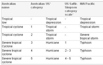
De stormen worden ingedeeld op 'categorie'. Vaak zijn het eerst tropische stormen" (Tropical Depression, Tropical Storms), die overgaan op Orkaanstatus (Hurricane/Tyfoons) Ze worden ingedeeld op windsnelheden via de Saffir-Simpson Schaal
Tropical Depression 24-38 mph winds (38-61 km/u)
Tropical Storm 39-73 mph winds (62-118 km/u)
Hurricane Categorie 1 74-95 mph winds (119-153 km/u) -- 4/5 ft Storm Surge -- Vb. Danny 1997, Stan 2005
Hurricane Categorie 2 96-110 mph winds (154-177 km/u) - 6/8 ft Storm Surge -- Vb. Danielle 2004
Hurricane Categorie 3 111-130 mph winds (178-209 km/u) - 9/12 ft Storm Surge - Vb.Fran 1996, Beta 2005
Hurricane Categorie 4 131-155 mph winds (210-249 km/u) - 13/18 ft Storm Surge - Vb.Hugo 1989, Frances 2004
Hurricane Categorie 5 > 156 mph winds (meer dan 250 km/u) -- 18ft or more S.S. -- Vb.Andrew 1992, Mitch 1998 en Wilma, Katrina 2005
Namen
De stormen, die vaak gevormd worden op de atlantische oceaan en dan richting de Caribbean of de Oostkust van de VS gaan, krijgen de naam op Alfabetische volgorde. Voor het seizoen 2005 zijn de namen als volgt:
Atlantische Stormen 2008
Arthur, Bertha, Cristobal, Dolly, Edouard, Fay, Gustav, Hanna, Ike, Josephine, Kyle, Laura, Marco, Nana, Omar, Paloma, Rene, Sally, Teddy, Vicky, Wilfred
In het oosten van de pacific ontstaan ook Hurricanes, ook wel Cylonen en/of Tyfoons genoemd. Deze zorgen vaak voor weinig schade aan de Amerikaanse westkust.
Oost Pacifische Stormen 2008
Alma, Boris, Cristina, Douglas, Elida, Fausto, Genevieve, Hernan, Iselle, Julio, Karina, Lowell, Marie, Norbert, Odile, Polo, Rachel, Simon, Trudy, Vance, Winnie, Xavier, Yolanda, Zeke
Verder zijn er dan nog de stormen in het Noorden, Zuiden en Westen van de Pacific. Met name de stormen in het Noord/Westen komen vaak in het nieuws omdat ze Japan, de Filipijnen, Taiwan en China vaak teisteren, maar ook geheel Zuid Oost Azie kunnen treffen. Meer informatie en de namen van deze stormen zijn hier terug te vinden.
Wanneer zijn die seizoenen nou precies?
ATLANTIC: 1 juni t/m 30 november
NORTH EAST PACIFIC Begin mei t/m begin November, met piek in Augustus/September
NORTH WEST PACIFIC Begin juli t/m eind November, maar eigenlijk hele jaar door aktiviteit.
NORTH INDIAN April t/m December met pieken in Mei en November
SOUTH INDIAN + WEST AUSTRALIAN Oktober t/m Mei met pieken in Februari en April
SOUTH WEST PACIFIC + EAST AUSTRALIANOktober tot eind April met piek in Februari.
Over het algemeen is Mei de rustigste maand en September de zwaarste.
Hoe ziet de voorspelling voor 2008 eruit
Volgens Phil Klotzbach en William Gray van CSU wordt 2008 een gemiddeld orkaanseizoen. Volgens hun ontstaan er 13 stormen die een naam krijgen, waarvan er 3 orkanen worden van categorie 3 of hoger. Ze verwachten een seizoen, redelijk gelijk aan de stormen van 2007. De voorspelling werd op 8 december 2007 gedaan.
Meer hierover kan je hier lezen.
Oude Delen
2004 - Deel 1 en Deel 2
2005 - Deel 1 en Deel 2
2006 - Deel 1 en Deel 2
2007 - Deel 1, Deel 2, Deel 3 en Deel 4
Enkele Links
1. National Hurricane Centre
2. Carribean Storm Network
3. Hurricanezone
4. Hurricane Track
5. Website met satelietbeelden van de Caribbean en de rest van Amerika
6. Intellicast: Geavanceerde satellietfoto's en gifs van aktuele stormen
7. Tropical Weather Underground
8. Tropical Storm Risico's van dit moment
9. Wikipedia Hurricanes/Tyfonen in het algemeen
10. Alle stormen ter wereld van de laatste jaren in overzicht
11. The StormTrack
12. Orkanensite in de Filipijnen
Opmerkelijke Links
Hurricane Season Special Edition Pagina van CNN van 2006
-- Hurricane Katrina CNN Special Report of the Killer Hurricane
-- Hurricane Katrina via WikiPedia
-- Hurricane Season 2005 -- Special van CNN
-- Hurricane Season 2004 -- Special van CNN
– Overzicht van Atlantische Stormen uit 2005
-- Spectaculaire Satelietshots van stormen
--Animatie van de alle Atlantische Stormen uit 2004
Openingspost
volgt nog
Actuele Radar in Golf van Mexico

Water temperatuur.
=====================
Post hier je gegevens, berichten, data en opmerkelijke zaken over Orkanen, Tyfoons en Hurricanes en van 2008.
[ Bericht 0% gewijzigd door Frutsel op 24-07-2008 09:43:45 ]

Mooie uitgebreide OP 
Op zaterdag 15 augustus 2009 23:05 schreef eer-ik het volgende:
Ik vind je sig nogal denigrerend.
Ik vind je sig nogal denigrerend.
quote:La Nina brews destructive cyclones off Australia 03 Jan 2008 04:15:30 GMT
Source: Reuters
By Michael Perry
SYDNEY, Jan 3 (Reuters) - A mature La Nina now exists over the Pacific and could produce up to 13 cyclones in Australia's current storm season, along with increased rainfall over the drought-hit nation, weather officials said on Thursday.
Every 30 years Australia's cyclone season, from November to April, reaches a peak and some forecasters say 2008 may become a peak storm season due to La Nina, which produces colder than average seas along the equator forcing warmer waters around Australia's northern coastline and fuelling cyclones.
Australia's northeast coast has been hit by one cyclone and is currently being battered by a severe storm with cyclonic winds, generating huge waves which closed scores of beaches, and caused coastal flooding and the evacuation of tourists.
A second cyclone is expected to form in the next few days in the Gulf of Carpentaria in northern Australia. Only two cyclones developed off the northeast coast last season.
Australia's northwest coast was last week buffeted by a cyclone, temporarily halting offshore oil and gas production.
"Now that La Nina is fully established one would think an above average cyclone season would probably occur," said Jim Davidson, regional director with the government's Bureau of Meteorology in the tropical Australian state of Queensland.
"Probably 12 or 13 (cyclones) in the Australian region," Davidson told Reuters on Thursday.
Australia's National Climate Centre said a weak La Nina over the Pacific had strengthened and was now a "mature event".
"A La Nina event is firmly established in the Pacific, strengthening over the past month and contributing to the enhanced eastern Australian rainfall since November," said the Centre's latest La Nina report released on Wednesday.
bron
Voor de kust van Darwin ( Australie ) is op dit moment een tropical low. Er wordt verwacht dat dit systeem binnen 12 uur zal uitgroeien tot een tropische storm. Het lijkt dus zeker wel een heftig seizoen te gaan worden daar in Australie.
Maar als er in de Atlantische Oceaan vorig jaar niet zo veel windshear was dan waren er denk ik wel 25 stormen of meer geweest.
Maar als er in de Atlantische Oceaan vorig jaar niet zo veel windshear was dan waren er denk ik wel 25 stormen of meer geweest.

Tropical Cyclone Melanie
Tropical Cyclone Melanie had an impressive appearance on December 30, 2007, as the storm swirled off the coast of Western Australia. Fortunately, the storm, which had sustained winds of 125 kilometers per hour (70 miles per hour), did not come ashore, and it brought only moderate storm conditions to the sparsely populated coast.
The Moderate Resolution Imaging Spectroradiometer (MODIS) on NASA’s Aqua satellite acquired this photo-like image at 2:10 p.m. local time (6:10 UTC) on December 20, 2007. The storm had basic spiral structure, with long arms of cloud wrapping around its center in a clockwise direction (characteristic of Southern Hemisphere cyclones). However, the storm system lacked a distinct eye, one indicator that it was not a powerful storm.
bron:
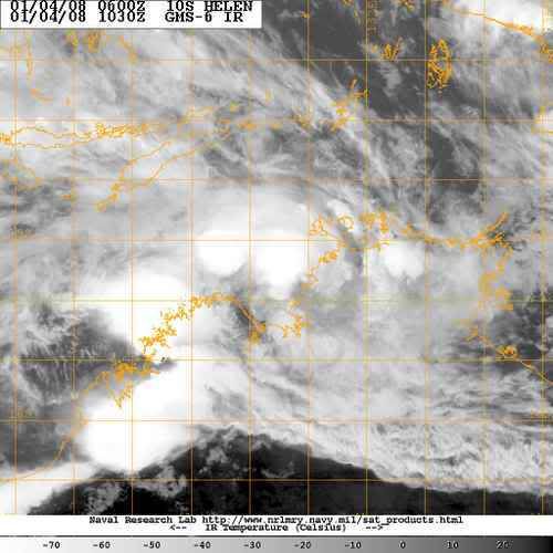

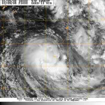
Cyclone Helen gaat veel neerslag achterlaten. Er wordt rond de 18 cm verwacht en golven rond de 5 meter...
[ Bericht 0% gewijzigd door #ANONIEM op 04-01-2008 13:16:12 ]
quote:Cyclone Helen due to hit NT coast
Email Print Normal font Large font January 4, 2008 - 7:24PM
Territorians were preparing for a night of fierce winds and violent rain across the Top End, as tropical cyclone Helen edges closer to the coast.
Gale force winds are expected to hit the Darwin region about 9pm (CST) on Friday night, with police calling on locals to make final preparations to their homes and stay indoors.
A cyclone warning has been declared for the capital and the Tiwi Islands, as well as all coastal communities between the remote Aboriginal community of Wadeye - otherwise known as Port Keats - and Cape Hotham.
Residents have been told to expect winds of up to 130km/h.
Meteorologist Gordon Jackson, from the Darwin Forecast Centre, said the cyclone would touch land - the point when winds are at their most intense - about 100km south-west of Darwin late on Friday night or early on Saturday.
As of 3.30pm, he said Helen was 225km west south-west of Darwin tracking at 16km/h.
"It is a Category 1 right now but we expect it to turn into a Category 2 over the next six hours," he told AAP.
"It's extremely unlikely it will reach a Category 3 before it crosses the coast."
Darwin has not been affected by a cyclone for a number of years although the infamous Cyclone Tracy devastated the city and killed 49 people on Christmas Eve in 1974.
There are concerns of major flooding across the Top End, including Wadeye, Daly River, Katherine and Adelaide River, 100km south of Darwin.
"There is going to be a lot of rainfall associated with the cyclone crossing the coast and there is a very good chance that there will be flooding in the low-lying areas and streams rising," said Todd Smith, duty forecaster at Darwin's cyclone warning centre.
Schools and day care centres within a 50km radius of Darwin were shut earlier on Friday. The cyclone warning also prompted the immediate closure of the Botanic Gardens, the Territory Wildlife Park and The Window on the Wetlands Visitor Centre on the Adelaide River floodplain.
Compass Resources has halted construction of a new mine at Batchelor, south of Darwin.
NT Police Commissioner Paul White urged people who intended to leave Darwin to escape the cyclone to do so immediately, although he added it was not a call to evacuate the city.
"I'm pleased with the level of preparations so far and urge all people in the areas likely to be affected to continue preparations," Comm White said in a statement.
"Those members of the public who as part of their cyclone plan would be leaving Darwin should start their journeys out of Darwin as soon as possible."
Nightcliff Jetty was closed, while Darwin's harbour has locked down containers and floating pontoons, with commercial ships asked to leave the port.
Public shelters will be opened in and around Darwin from 6pm (CST).
Cyclone Helen is expected to weaken to below cyclone intensity over land on Friday, but it may redevelop in the Gulf of Carpentaria on Sunday.
A cyclone warning was cancelled for Kalumburu in Western Australia late on Friday, and a cyclone watch was declared for coastal and island communities from Elcho Island to Numbulwar.
[ Bericht 0% gewijzigd door #ANONIEM op 04-01-2008 13:16:12 ]
Cyclone Helen is een categorie 2, (Tropische storm volgens de Saffir Simpson schaal) zal over land afzwakken om vervolgens te herstellen boven de the Gulf of Carpentaria
[ Bericht 1% gewijzigd door #ANONIEM op 04-01-2008 13:48:14 ]
quote:At 6:30 pm CST Tropical Cyclone Helen, Category 2 was estimated to be
95 kilometres west of Daly River Mouth and
185 kilometres west southwest of Darwin and
moving east at 15 kilometres per hour.
The cyclone is expected to cross the coast near Daly River Mouth in the next few
hours. Tropical Cyclone Helen is expected to weaken below cyclone intensity over
land tomorrow, but may continue to move east and redevelop in the Gulf of
Carpentaria on Sunday.
DESTRUCTIVE WINDS with gusts to 130 kilometres per hour are expected to affect
coastal and island communities between Darwin and Daly River Mouth in the next
few hours.
GALES with gusts to 100 kilometres per hour are currently being experienced on
parts of the coast between Darwin and Port Keats, and may extend to Cape Hotham
and the Tiwi Islands later tonight. These conditions are expected to continue
for the next 6 to 12 hours.
GALES with gusts to 100 kilometers per hour may affect coastal and island
communities between Elcho Island and Numbulwar, including Nhulunbuy and Groote
Eylandt, on Sunday if the system redevelops in the Gulf of Carpentaria.
Heavy rain is expected to cause flooding over the Top End.
[ Bericht 1% gewijzigd door #ANONIEM op 04-01-2008 13:48:14 ]
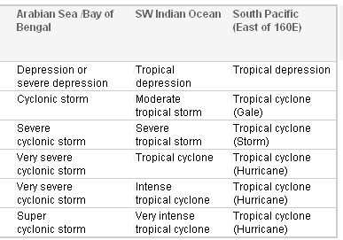
De schalen die in verschillende gebieden (anders) wordt gebruikt
[ Bericht 39% gewijzigd door #ANONIEM op 04-01-2008 13:44:54 ]
[ Bericht 39% gewijzigd door #ANONIEM op 04-01-2008 13:44:54 ]
Tropische storm Helen neemt boven land nog in kracht toe.
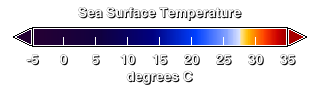
temperatuur water Australie
temperatuur water Australie
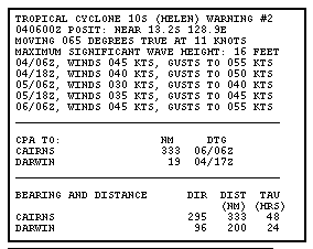
quote:The Bureau of Meteorology says Tropical Cyclone Helen has not weakened, despite being over land for a few hours.
A cyclone warning is current for coastal and island communities from Port Keats to Cape Hotham, including Darwin and the Tiwi Islands.
A cyclone watch is current for coastal and island communities from Elcho Island to Numbulwar, including Nhulunbuy and Groote Eylandt.
The category two system is estimated to be 100 kilometres south-south-west of Darwin and moving east at 18 kilometres per hour.
Cyclone Helen crossed the coast near Channel Point about 11:00pm (ACDT) and is currently situated between Channel Point and Adelaide River.
The bureau says because the cyclone kept its structure so well, the strong winds might extend through Adelaide River over the next few hours.
Power out, gale force winds as Cyclone Helen batters NT
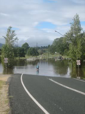
Evacuaties Australië na overstromingen
SYDNEY - De Australische autoriteiten hebben zaterdag in het oosten van het land vijfhonderd mensen geëvacueerd wegens overstromingen als gevolg van zware regenval.
Veel mensen zaten vast in hun huizen, caravans en auto's. Het noodweer is een uitloper van de cycloon Helen, die inmiddels is afgezwakt tot een zware storm.
De afgelopen week zijn rivieren in Queensland en New South Wales buiten hun oevers getreden. Voor zover bekend zijn er geen gewonden of doden.
Nu.nl
[ Bericht 6% gewijzigd door #ANONIEM op 05-01-2008 11:12:43 ]
Duizenden Australiërs ingesloten door hoogwater
CANBERRA - Duizenden Australiërs in de deelstaten New South Wales en Queensland zijn ingesloten geraakt door grootschalige overstromingen als gevolg van aanhoudend noodweer.
De schade loopt in de miljoenen, melden Australische kranten in hun maandagedities.
Afgesloten
De autoriteiten hebben al gezegd dat sommige gemeenschappen waarschijnlijk nog dagen van de buitenwereld afgesloten zullen zijn.
Wegen zijn verwoest en bruggen zijn weggeslagen. In sommige districten is de noodtoestand van kracht om zo de komst van federale hulp te kunnen versnellen.
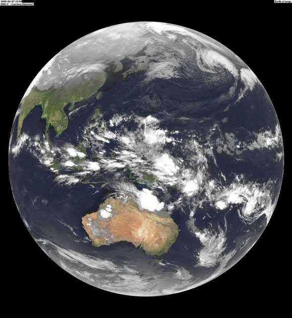

van deze site http://www.fvalk.com/day_image.htmquote:Op maandag 7 januari 2008 20:34 schreef Frutsel het volgende:
Waar haalde je die foto's ook alweer vandaan Aloa?
Hmm... komt me niet bekend voorquote:Op maandag 7 januari 2008 21:30 schreef aloa het volgende:
[..]
van deze site http://www.fvalk.com/day_image.htm
misschien bedoelde je dezequote:Op maandag 7 januari 2008 21:32 schreef Frutsel het volgende:
[..]
Hmm... komt me niet bekend voorThx
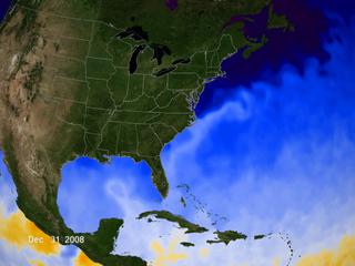
wereldkaart
Bangladesh to build 2,000 cyclone shelters in 2008
DHAKA, Jan 8 (Reuters) - Bangladesh, still struggling to overcome the devastating effects of cyclone Sidr late last year, will build 2,000 new storm shelters in 2008.
"Some 2,000 new cyclone shelters will be built in 15 low-lying coastal districts, which had been trampled by the Nov. 15 cyclone," Food and Disaster Management Secretary Mohammad Ayub Miah told Reuters on Tuesday.
The worst cyclone since 1991 killed more than 3,300 people, made millions homeless and washed away around 1 million tonnes of rice, the country's main staple food.
The disaster-prone south Asian country of more than 140 million people currently has around 1,500 shelters, each capable of offering refuge to up to 5,000 people on average, officials said.
During storms and floods, people also take shelter in high-rise buildings, including schools.
Aid agencies say Bangladesh has made huge strides in reducing death tolls from the cyclones that batter its coastline every year due to improved preparedness measures.
These include advance warnings, quick removal of people from disaster areas and better rescue and relief operations.
Bangladesh's worst cyclone in 1991 killed around 140,000 people. (Reporting by Ruma Paul; writing by Anis Ahmed; Editing by Alex Richardson) (Bron: Reuters)