WKN Weer, Klimaat en Natuurrampen
Lees alles over het onstuimige weer op onze planeet, volg orkanen en tornado's, zie hoe vulkanen uitbarsten en hoe Moeder Aarde beeft bij een aardbeving. Alles over de verwoestende kracht van onze planeet en tal van andere natuurverschijnselen.


Moet je d'r eens eentje vinden met een 'open' oog, het stadium effect noemen ze dat geloof ik. Ik ga effe op zoek.
Als ik goed onthouden heb wat ik vanmorgen heb gehoord dan waren er "hurricane force winds" tot op 95 km van het oog, en "tropical storm force winds" tot op 300 km. Die 300 km weet ik niet meer zeker, maar tropical storm force winds noemen we hier gewoon windkracht 8. Niet echt strandweer meer dusquote:Op maandag 20 augustus 2007 13:47 schreef Stratos het volgende:
Hoewel het centrum van orkaan 250km ten noorden van Aruba is vertrokken, werden de stranden geteisterd door enorme golven van soms 5 meter hoog.
Stormvloed in goed ABN.quote:Op dinsdag 21 augustus 2007 02:42 schreef Frutsel het volgende:
stormsurge van 6 meter
NHC gaat uit van gemiddeld 260 km/h, stoten ver daarboven. Denk aan ruim 320!
Echter, geven ze aan dat dit een conservatieve indicatie is! De kans is groot dat de wind sterker is dan dit.
Echter, geven ze aan dat dit een conservatieve indicatie is! De kans is groot dat de wind sterker is dan dit.
Ik HAAT mijn toetsenbord.

oog staat op het punt om aan land te komen (satelliet-beeld van kwartier geleden)
er is al schade gemeld op San Pedro, een klein eilandje voor de kust van Belize.
bulletin 8:00:
extra bulletin 8:25:quote:MAXIMUM SUSTAINED WINDS ARE NEAR 160 MPH...260 KM/HR...WITH HIGHER
GUSTS. DEAN IS A POTENTIALLY CATASTROPHIC CATEGORY FIVE HURRICANE
ON THE SAFFIR-SIMPSON HURRICANE SCALE. LITTLE CHANGE IN STRENGTH
IS EXPECTED PRIOR TO LANDFALL. ALTHOUGH SOME WEAKENING IS FORECAST
AS DEAN CROSSES THE YUCATAN PENINSULA...DEAN IS EXPECTED TO
MAINTAIN HURRICANE STRENGTH THROUGHOUT THE NEXT 24 HOURS.
HURRICANE FORCE WINDS EXTEND OUTWARD UP TO 60 MILES...95 KM...FROM
THE CENTER...AND TROPICAL STORM FORCE WINDS EXTEND OUTWARD UP TO 175
MILES...280 KM.
THE MINIMUM CENTRAL PRESSURE ESTIMATED FROM THE AIRCRAFT DATA IS
911 MB...26.90 INCHES.
lagere luchtdruk dus.quote:DROPSONDE DATA FROM THE AIR FORCE RESERVE HURRICANE HUNTER AIRCRAFT
INDICATE THAT THE MINIMUM CENTRAL PRESSURE IN THE EYE OF HURRICANE
DEAN IS NOW 909 MB...26.84 INCHES.
dus windsnelheid zal ook hoger zijn zo vlak voor het aan land komen.
Dostojewski: "Je kunt je niet van je eigen gezond verstand overtuigen door je buurman op te sluiten."
The Weather Radio Broadcast Network geeft Love FM - radiozender Belize door.
voornamelijk Engels maar ook Spaanstalig.
http://www.wrbn.net:9462/listen.pls
voornamelijk Engels maar ook Spaanstalig.
http://www.wrbn.net:9462/listen.pls
Dostojewski: "Je kunt je niet van je eigen gezond verstand overtuigen door je buurman op te sluiten."

Een vliegtuig van NOAA vliegt op dit moment dor de orkaan. Dit is te volgen via google earth (zoek op google naar hurricane recon lankamp, de xml link opent in google earth). Op vliegniveau zit het nu rond 170 knopen. Dat wil zeggen: ongever 270 km/h gemiddeld aan de grond!
Ik HAAT mijn toetsenbord.
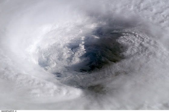
.quote:Op dinsdag 21 augustus 2007 08:35 schreef Caesu het volgende:
[afbeelding]
oog staat op het punt om aan land te komen (satelliet-beeld van kwartier geleden)
er is al schade gemeld op San Pedro, een klein eilandje voor de kust van Belize.
bulletin 8:00:
[..]
extra bulletin 8:25:
[..]
lagere luchtdruk dus.
dus windsnelheid zal ook hoger zijn zo vlak voor het aan land komen.
Ben benieuwd wat er overblijft daar ....
quote:I was the person that discovered the HF mechanism for the formation of this high altitude global warming blanket. One of the problems is this blanket is disrupted over the polar regions by the Van Allen radiation effects stirring the air, which goes to accelerate the polar ice melt rates.
This discovery set of a panic in the national lab systems and the US Government due to the projected harm effects due to the strength of storm problems, greater rates of earthquakes, more severe tropical storms, more volcanic activity, and etc.
http://members.aol.com/doewatch/chemtrails.html
We must guard against the aquisition of unwarranted influence, whether sought or unsought, by the military-industrial complex.
We must never let the weight of this combination endanger our liberties or democratic processes.
Eisenhower1961.
We must never let the weight of this combination endanger our liberties or democratic processes.
Eisenhower1961.

oog komt nu aan land. satelliet beeld van 8 minuten oud.
Dostojewski: "Je kunt je niet van je eigen gezond verstand overtuigen door je buurman op te sluiten."
Op CNN hadden ze 't net over landfall over ongeveer 2 a 3 uur. Vraag me af wat ze bedoelen met "landfall", is dan het oog bij 't land? of de gehele storm? of euh?quote:Op dinsdag 21 augustus 2007 09:34 schreef Caesu het volgende:
[afbeelding]
oog komt nu aan land. satelliet beeld van 8 minuten oud.
Verder is er nu eindelijk ook op CNN veel te horen over deze orkaan, was de afgelopen dagen niet echt zo. Er staan weer her en der verslaggevers in de storm, dus dat wordt een paar uurtje mooie televisie straks
Mooi oranje is niet lelijk!
Op dit moment ligt het oog precies boven Banco chinchorro, een koraalrif, naast puerto costa maya.
Ik HAAT mijn toetsenbord.
10 min. geleden.
http://weather.msfc.nasa.gov/cgi-bin/post-goes (zet op quality 100% en klik-zoom op het oog)

http://weather.msfc.nasa.gov/cgi-bin/post-goes (zet op quality 100% en klik-zoom op het oog)
Dostojewski: "Je kunt je niet van je eigen gezond verstand overtuigen door je buurman op te sluiten."
dit is de eerste keer na Andrew 1992 dat een hurricane met CAT5 direct aan land komt.
top 10 Hurricanes
1 Wilma 882 mbar (hPa)
2 Gilbert 888 mbar (hPa)
3 "Labor Day" 892 mbar (hPa)
4 Rita 895 mbar (hPa)
5 Allen 899 mbar (hPa)
6 Katrina 902 mbar (hPa)
7 Camille 905 mbar (hPa)
8 Mitch 905 mbar (hPa)
9 Dean 909 mbar (hPa) misschien maar 903 mbar
10 Ivan 910 mbar (hPa)
huilende en biddende mensen op Love FM Belize.
daarnet was er een hoogzwangere vrouw die naar het ziekenhuis moest in Belize City en vroeg om assistentie.
http://www.wrbn.net:9462/listen.pls
BBC World Service belde net de radiozender op.
[ Bericht 14% gewijzigd door Caesu op 21-08-2007 10:30:01 ]
Dostojewski: "Je kunt je niet van je eigen gezond verstand overtuigen door je buurman op te sluiten."
Geen metingen van de omgeving meer. Is geevacueerd en de stroom is uit voorzorg uit.
Ik HAAT mijn toetsenbord.
Storm DEAN: Observed By Air Force #303
Storm #04 in Atlantic Ocean
Maximum Flight Level Winds Were 162KT (186.3mph 300.0km/h) In NW Quadrant At 2358Z
Estimated Max Surface Winds 145.8KT (167.7mph 270.0km/h) * Misc Remarks:
Date/Time of Recon Report: NaN (NaN)
Position of the center: 18° 17' N 085° 00' W (18.3°N 85.0°W) [See Map]
Minimum Height Measured At Standard Level Of 700mb: 2359m (Normal: 3011)
Surface Winds Were Estimated At: 121KT (139.15MPH 224.1km/h)
Estimated Surface Winds Were Measured 9nm (10.35miles) From Center At Bearing 318°
Maximum Flight Level Winds Near Center Were 156KT (179.4mph 288.9km/h) From 047°
Maximum Flight Level Winds Were Measured 8nm (9.2 miles) From Center At Bearing 318°
Minimum pressure: 914mb (26.99in)
Eye Wall Was Characterized As Being: CLOSED WALL
Eye Form Was Characterized As Being Circular , 16 nm (18.4 mi 29.6km) wide
Center Fix Established Using: Penetration Radar Wind Pressure Temperature
Center Fix Established At Level(s): 700mb
Navigational Accuracy Measured At 0.02nm
Meteorological Accuracy Measured At 2nm
* = Estimated Surface Winds are assumed 90% of Max Flight Level Winds
Ik HAAT mijn toetsenbord.
quote:Maximum sustained winds are near 165 mph...270 km/hr...with higher
gusts. Dean is a category five hurricane on the Saffir-Simpson
scale. Although some weakening is forecast as Dean crosses the
Yucatan Peninsula...Dean is expected to maintain hurricane strength
throughout the next 24 hours.
Hurricane force winds extend outward up to 60 miles...95 km...from
the center...and tropical storm force winds extend outward up to 175
miles...280 km.
The hurricane hunter plane reported a minimum central pressure of
906 mb...26.75 inches...just before landfall.
Storm surge flooding of 12 to 18 feet above normal tide levels along
with large and dangerous battering waves is possible near and to
the north of where Dean made landfall along the East Coast of the
Yucatan Peninsula.
Dean is expected to produce storm total rainfall of 5 to 10 inches
over The Isthmus of Tehuantepec and Yucatan Peninsula of Mexico...
Belize...Guatemala...and northern Honduras...with maximum amounts
of up to 20 inches. These rains could cause life-threatening flash
floods and mud slides.
SOME HISTORIC NOTES ARE IN ORDER HERE. THE 906 MB
CENTRAL PRESSURE IS THE NINTH LOWEST ON RECORD FOR AN ATLANTIC
BASIN HURRICANE...AND THE THIRD LOWEST AT LANDFALL BEHIND THE 1935
LABOR DAY HURRICANE IN THE FLORIDA KEYS AND HURRICANE GILBERT OF
1988 IN CANCUN MEXICO. DEAN IS ALSO THE FIRST CATEGORY FIVE
HURRICANE TO MAKE LANDFALL IN THE ATLANTIC BASIN SINCE ANDREW OF
1992.
Dostojewski: "Je kunt je niet van je eigen gezond verstand overtuigen door je buurman op te sluiten."
Beelden en verslag zijn natuurlijk ook live te volgen op http://www.cnn.com/video (klik op live video).

Op CNN is nu al een tijdje een live uitzending bezig, dus als je up-to-date wilt blijven kun je ook CNN kijken. Ze bellen elke keer met mensen in de buurt en zo af en toe komen er wat beelden voorbij.
Mooi oranje is niet lelijk!

zeker weer van die sensatie reporters die nu in de stromende regen en windstoten verslag staan te doen

Die link doet het nietquote:Op dinsdag 21 augustus 2007 09:51 schreef Caesu het volgende:
http://weather.msfc.nasa.gov/cgi-bin/post-goes (zet op quality 100% en klik-zoom op het oog)
Zie ook http://www.nhc.noaa.gov/text/refresh/MIATCPAT4+shtml/211145.shtml .quote:HURRICANE DEAN HAS BEEN DOWNGRADED TO A CATEGORY 3 STORM, THE NATIONAL HURRICANE CENTER REPORTS

Zoiets? http://www.hurricanecity.com/live1.htmquote:Op dinsdag 21 augustus 2007 14:41 schreef SolidArt het volgende:
Is er geen streaming feed ergens ter plekke?
Presidential elections in Jamaica have been delayed due to damage caused by hurricane Dean, according to the Associated Press.
Dan zie ik alsnog niets waar ik bijvoorbeeld de kwaliteit kan instellen.quote:Op dinsdag 21 augustus 2007 13:48 schreef mostardos het volgende:
[..]
haal "/cgi-bin/post-goes" weg en je ziet het wel.
haal die lijn weg, klik op het plaatje, klik op het middelste plaatje, en daar kan je dan dingen instellen, als je het op 100% hebt neergezet kun je op de kaart klikken en dan krijg je dat gebied.
zo hoop ik dat het iets duidelijker is.
zo hoop ik dat het iets duidelijker is.
A Mean Dean Takes Aim on Mexico's Yucatan
+ Larger view (750Kb)
Hurricane Dean, expected to become a Category Five storm with maximum sustained winds of at least 135 knots (155 miles per hour), steams through the western Caribbean on its way to a projected landfall in Mexico's Yucatan Peninsula. In this August 20 image from NASA's QuikScat satellite, white arrows showing wind direction are superimposed on color images of wind speed.
Image credit: NASA/JPL
Klik voor filmpje download
Tropical Storms, Typhoons, and Hurricanes from the 2007 Season
[ Bericht 7% gewijzigd door -CRASH- op 21-08-2007 17:30:40 ]
<a href="http://www.vwkweb.nl/" rel="nofollow" target="_blank">Vereniging voor weerkunde en klimatologie</a>
<a href="http://www.estofex.org/" rel="nofollow" target="_blank">ESTOFEX</a>
<a href="http://www.estofex.org/" rel="nofollow" target="_blank">ESTOFEX</a>
Dean weakens over Yucatan to Category 2 (CNN)
CHETUMAL, Mexico (CNN) -- Hurricane Dean, weakened to a Category 2 storm, sprinted across Mexico's Yucatan Peninsula on Tuesday, knocking down trees and flooding streets but not inflicting catastrophic damage.
Dean charged ashore before dawn as a monster Category 5 storm but rapidly lost strength as it traversed the peninsula and was downgraded to a Category 2 at 10 a.m. (11 a.m. ET).
Downed power lines and damaged buildings were reported in Mexico and northern Belize, but no casualties.
Streets were flooded outside a hotel in Chetumal, just south of where Dean's center made landfall around 4:30 a.m. (5:30 a.m. ET) with maximum sustained winds of 165 mph (266 kph), according to the National Hurricane Center.
Two hotel workers tried to clear a clogged street drain with a garden rake in an effort to relieve the flooded streets.
The storm's eye passed just south of the resort areas of Cozumel and Cancun, striking a rural and sparsely populated area near Chetumal, the capital of the Mexican state of Quintana Roo.
At 10 a.m. (11 a.m. ET), the weakened hurricane had maximum sustained winds of 105 mph (165 kph) and was 90 miles (150 km) west-northwest of Chetumal, according to the hurricane center. It was moving west at 20 mph (32 kph).
The storm is expected to lose more strength as it passes across the Yucatan, before re-emerging in the Gulf of Mexico. It is forecast to strengthen again and hit central Mexico Wednesday with winds around 100 mph (161 kph)
Electricity was out in Chetumal, where most of the 130,000 residents in the coastal city appeared to have heeded government warnings to seek shelter or evacuate. Watch Dean blow into Chetumal »
Telephones were working in Chetumal, and three radio stations were still broadcasting the location of the storm to residents early Tuesday, Quintana Roo Gov. Felix Arturo Gonzalez Canto told CNN's "American Morning."
"This information is very essential to the people of the area where the hurricane is hitting," Gonzalez Canto said. He said the reports give people "assurance of what's happening and also a lot of tranquillity."
Of the 20,000 tourists in Quintana Roo, about 13,000 had been evacuated as of Monday evening, said Rosario Ortiz Yeladaque, the state's secretary of government.
About 20,000 tourists remained in Cancun hotels. Security guards at the Gran Melia Hotel prevented guests and journalists from going outside into the storm by chaining and barricading exits, according to CNN's Jason Carroll.
Dean is so large -- about the size of Texas -- that its tropical winds and waves affected the entire Yucatan and neighboring Belize to the south.
Jeff Spiegel, owner of the Azul Resort in Amerbergris Caye, Belize, said it was "incredibly windy" and the ocean surge was "very, very high." Most of the docks and piers have been washed away on the western side of his narrow island, he said.
Douglas Podzun, owner of the Corozal Bay Inn, said he traveled outside early Tuesday to rescue a relative and witnessed some of the damage in the northern Belize town of Corozal.
"There are downed power lines, there's a lot of trees down, a lot of streets with roofing laying around that have been blown off of houses, and cars shaking," Podzun said. "[There's] nobody on the street at all, not even the police. The police said if anybody needs help they're on their own because they're not going out anymore."
The Mexican government deployed 4,000 troops Monday, and a state of emergency was declared in the state of Campeche, where residents were bracing for as much as 20 inches of rain in some places.
Mexican President Felipe Calderon, who was in Canada for a trilateral meeting with President Bush and Canadian Prime Minister Stephen Harper, cut short his visit and prepared to return home Tuesday to deal with the storm.
In anticipation of the storm, parts of Belize, including Belize City, were put under a curfew Monday night, and Prime Minister Said Musa froze prices of goods and services to prevent price gouging. People were being evacuated from low-lying, coastal and valley areas to hurricane shelters, the prime minister's office said.
Forecasters do not believe the storm presents a threat to the United States, although officials in Texas continued to make storm preparations just in case Dean's path takes an unexpected turn.
Along the northern Yucatan coast, winds were only expected to reach tropical-storm force, above 39 mph (63 kph).
Meanwhile, in Jamaica, residents cleaned up fallen trees and debris Monday as the island nation started to recover from its brush with Dean on Sunday. See I-Reports of what Dean has done across the Caribbean »
While electric service was still out and most stores were closed, the international airport in Montego Bay reopened Monday night, allowing tourists who had been caught in the storm to begin leaving.
Although parts of Jamaica were pounded with sustained winds of 114 mph (183 kph), the eye of the hurricane passed to the south of the island, sparing its 2.8 million residents from a direct hit. Two deaths were reported in Jamaica, and the storm caused property damage and triggered landslides in some rural areas.
Dean is being blamed for at least seven other deaths in its march across the Caribbean, including two fatalities in Haiti, two in both Martinique and Dominica, and one in St. Lucia.