WFL Wetenschap, Filosofie, Levensbeschouwing
Discussieer hier over alle aspecten van de wetenschap, filosofische problemen en zaken van levensbeschouwelijke aard.


Van welke site heb je deze afbeelding?quote:Op maandag 17 oktober 2005 00:05 schreef Drugshond het volgende:
Wilma : verwachtingen.
[afbeelding]
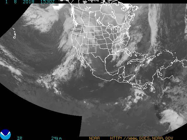
Weet iemand de temperatuur van het water tussen de driehoek van Cuba, Mexico en ZE-Amerika. Is de watertemperatuur nog steeds een voedingsbodem voor orkaans ? En wie heeft daar een plaatje van.
Kein gewalt! Wir sind das volk!
Steps taken forwards but sleepwalking back again.
''And the Germans kill the Jews, And the Jews kill the Arabs, And the Arabs kill the hostages
And that is the news.''
Steps taken forwards but sleepwalking back again.
''And the Germans kill the Jews, And the Jews kill the Arabs, And the Arabs kill the hostages
And that is the news.''
quote:While in the Caribbean, there is still plenty of energy available for a major hurricane to develop. As you can see in the Tropical Cyclone Heat Potential (TCHP) chart below, the Gulf is still primed for intensification.

However, once the system enters the Gulf of Mexico, there is much less energy available. Although this is a significant decrease in available energy, it is still capable of supporting a hurricane. (Just not as strong.) The Loop Current in the Gulf shows up especially well.

As is shown below, the northern half of the Gulf is NOT capable of supporting a Category 5 hurricane any more this year. It seems like even a Category 4 may be a stretch at this point. However, a major Category 3, as Ivan and Katrina were (we can argue about this one later), can cause major damage.

www.nhc.noaa.govquote:Op maandag 17 oktober 2005 17:18 schreef One_of_the_few het volgende:
[..]
Van welke site heb je deze afbeelding?
Doe mee met het voorspellen van het weer!
Weekvoorspelling | Week 12 (invullen tot 16-03 - 11:59)
Maandvoorspelling Maart (Inzendingen gesloten)
Jaarvoorspelling 2025 / 2026
Weekvoorspelling | Week 12 (invullen tot 16-03 - 11:59)
Maandvoorspelling Maart (Inzendingen gesloten)
Jaarvoorspelling 2025 / 2026
http://news.bbc.co.uk/2/hi/americas/4349378.stm :
quote:Storm record equalled in Atlantic
A new tropical storm has formed in the Caribbean, equalling a 70-year-old record for the highest number of storms in the Atlantic in a single season.
Tropical Storm Wilma is expected to become a hurricane before heading to the Yucatan peninsula in Mexico and the US Gulf coast by the end of the week.
These areas are still recovering from the devastation caused by hurricanes Katrina and Stan.
Wilma is the 21st named storm of the 2005 season.
The only other time that as many storms formed since record keeping began 154 years ago was in 1933.
'Moving erratically'
Wilma formed in the north-western part of the Caribbean Sea early on Monday, threatening the Cayman Islands.
A warning was issued there, meaning that hurricane conditions could be felt within 36 hours.
The National Hurricane Centre in the United States said that Wilma is moving erratically, with sustained winds of 65km/h (40 mph), and is expected to bring heavy rain in the Cayman Islands and Jamaica.
Long-term forecasts show the storm heading towards the Gulf of Mexico and the US Gulf coast within the next two to three days.
Nearly 1,200 people were killed in the United States by Hurricane Katrina in August.
Hundreds more died in Mexico and Central America when Tropical Storm Stan struck early this month.
MIAMI - Het Caribisch gebied moet zich opmaken voor een nieuwe zware orkaan. De tropische storm Wilma, die zich nu tussen Honduras en Jamaica bevindt, dreigt de komende dagen uit te groeien tot een "intense orkaan", waarschuwde het Amerikaanse Nationale Orkanen Centrum dinsdag.
Wilma koerst af op het Mexicaanse schiereiland Yucatan, Cuba en het zuiden van Florida. De windsnelheden van de storm zijn inmiddels opgelopen tot 110 kilometer per uur. Wilma zal naar verwachting dinsdag toenemen tot orkaankracht. Daarmee wordt het de twaalfde orkaan van het seizoen.
Wilma koerst af op het Mexicaanse schiereiland Yucatan, Cuba en het zuiden van Florida. De windsnelheden van de storm zijn inmiddels opgelopen tot 110 kilometer per uur. Wilma zal naar verwachting dinsdag toenemen tot orkaankracht. Daarmee wordt het de twaalfde orkaan van het seizoen.
Toch belangrijk ? 'less reliable data'quote:Record Season
There are six weeks left in this year's record-breaking June 1-Nov. 30 hurricane season. Katrina was the costliest ever U.S. natural disaster when it slammed into Louisiana in August, killing about 1,250 people. Spain was hit this month by its first tropical cyclone ever.
This year's Atlantic hurricane season has been the busiest since systematic aircraft reconnaissance of weather systems began in 1944. Until this year, that mark stood at 19, in 1995, though less reliable data indicate 1933 had 21 storms, according to the National Oceanic and Atmospheric Administration.
bron Bloomberg
In sommige interviews vergeet men dat te melden terwijl het toch van belang is als men wil vergelijking maken.
ik wou da even benadrukken, bij deze.
De kans lijkt me minstens zo groot dat ze in '33 een stormpje hebben gemist dan dat ze er een teveel hebben geteld.
Overigens: Wilma is inmiddels officieel orkaan geworden.
Overigens: Wilma is inmiddels officieel orkaan geworden.
Dat kan ook natuurlijkquote:Op dinsdag 18 oktober 2005 18:27 schreef thijsdetweede het volgende:
De kans lijkt me minstens zo groot dat ze in '33 een stormpje hebben gemist dan dat ze er een teveel hebben geteld.
Overigens: Wilma is inmiddels officieel orkaan geworden.
Ik wou even aangeven dat betrouwbare gegevens beschikbaar sinds 1944.
Maar soit.
ontopic
Wilma da word andere koek.

Bekijk voor de grap de loop eens...
quote:bron : AccuWeather
Hurricane Wilma continues to gather steam over the warm waters of the Caribbean. The storm will reach Category 3 strength by the end of Wednesday and could become a Category 4 hurricane for a while on Thursday or Friday. The AccuWeather.com forecasted track of Wilma shows the storm becoming a serious threat to Florida this weekend. Deviations in the path are still possible, but currently we feel southern and central Florida will experience the full fury of the storm. When the storm makes landfall this weekend, the west coast of Florida somewhere between Tampa and the Keys could be pounded by winds over 100 mph and a destructive storm surge. Torrential rain brought by the storm will be widespread across a large portion of the state.
Story by AccuWeather.com expert senior meteorologist John Kocet.
quote:Bron : hurricanetrack.com/
UPDATED: 4:55 PM EDT, October 18, 2005
WILMA NOW FORECAST TO BE VERY STRONG CAT-3/4 HURRICANE
The latest info coming from the NHC suggests that Wilma could become a strong category three and perhaps even a category four hurricane before making landfall. This is obviously not good news for the people in the path of this hurricane. It seems that environmental conditions will be very favorable for Wilma to become an intense and very dangerous hurricane. With that being said, I urge people within the cone of probability to start taking preparedness action now. Remember- your local authorities have hurricane plans in place to deal with such an event. Also remember too that a lot of people are in Florida now as "Snowbirds" and may not be used to hurricane threats. Time is on your side now- use it wisely and prepare for the worst. It looks like Wilma will come in and move out fairly quickly and we will have to see if it comes out close enough to the coast so that people along the Outer Banks of North Carolina have to worry. I am not sure that this will be the case right now- but it is something we will need to watch.
I am leaving for Naples, FL in the morning and will have full updates while en route. My colleague from Ft. Lauderdale, Mike Watkins, will produce a nice video report tomorrow evening to explain things to people using excellent graphics and simple terms so that folks understand what they're up against. That video will be online here near 7pm tomorrow evening. I will post another text update here later this evening- near the 11pm EDT advisory time.
Kijk eens goed naar de snelheid van de orkaan bij de laatste increment (van Sat naar Sun)
Diit zou voorspellen dat in het laatste van de trajectorie de orkaan een behoorlijke horizontale snelheid van beweging heeft. Nou vraag ik mezelf af, wat het effect is van deze horizontale beweging op de voedingsbodem van deze orkaan.
Op het internet heb ik sites gezien dat een horizontale snelheid voor een orkaan van 60 km/h niet ongewoon is....Rita was 15 km/h er verloor vooral het laatste stuk veel kracht.
Als ze boven land komt zwakt ze af en stort ze alsware gedeeltelijk in waardoor het dan snel kan gaan lijkt mij
Ik weet wel dat ze ons weer in de war gaat halen.
Ik weet wel dat ze ons weer in de war gaat halen.
Doe mee met het voorspellen van het weer!
Weekvoorspelling | Week 12 (invullen tot 16-03 - 11:59)
Maandvoorspelling Maart (Inzendingen gesloten)
Jaarvoorspelling 2025 / 2026
Weekvoorspelling | Week 12 (invullen tot 16-03 - 11:59)
Maandvoorspelling Maart (Inzendingen gesloten)
Jaarvoorspelling 2025 / 2026
Dat is mijn vraag niet : Is een flinke horizontale snelheid funest voor een orkaan, of juist een voedingsbodem ?quote:Op woensdag 19 oktober 2005 06:54 schreef SpeedyGJ het volgende:
Als ze boven land komt zwakt ze af en stort ze alsware gedeeltelijk in waardoor het dan snel kan gaan lijkt mij
Ik weet wel dat ze ons weer in de war gaat halen.
En bovendien :
Met zo'n snelheid zou je denken dat de orkaan overlevenskansen heeft na Florida.
Kan hij een tweede landfall maken : North and South Carolina ?
Binnen 11 uur van Cat 1 naar Cat 4quote:Bron : CNN
Hurricane Wilma now 'extremely dangerous'
Hurricane Wilma now 'extremely dangerous'
Category 4 storm has top sustained winds of 150 mph
MIAMI, Florida (CNN) -- Hurricane Wilma rapidly intensified from a Category 2 to a Category 4 hurricane early Wednesday with maximum sustained winds of 150 mph, and forecasters warned it could become a Category 5 hurricane later in the day before possibly slamming into Florida by this weekend.
At 1 a.m. EDT, the National Hurricane Center reported an Air Force plane had found 150 mph winds with higher gusts in Wilma.
"Wilma is an extremely dangerous Category 4 hurricane on the Saffir-Simpson scale," the center said in an advisory. "The hurricane could become a Category 5 hurricane today."
The storm has already left seven to 10 people dead in Haitian mudslides caused by heavy rains, government officials told Reuters news agency.
The latest in a slew of devastating storms to sock the Gulf region, Wilma became a hurricane Tuesday -- tying the record for both most hurricanes in a season with 12 and most named storms at 21.
Just nine hours after becoming a hurricane, Wilma's wind speeds had jumped from 75 mph to 100 mph. Then, within two hours, the winds intensified from 110 to 150 mph.
At 2 a.m. EDT, the center of the storm was located 170 miles south-southwest of Grand Cayman Island and about 400 miles southeast of Cozumel, Mexico. It was moving west-northwest at nearly 8 mph and is expected to turn to the northwest over the next 24 hours, the hurricane center said.
A Category 4 hurricane can cause a storm surge of 18 feet above normal and cause complete destruction of mobile homes, extensive damage to doors and windows of structures and major damage to lower floors of structures near the shore.
Projections for Wilma's path suggest the storm may skirt the western tip of Cuba on Friday, possibly as a Category 4 storm with winds of greater than 130 mph, before curving eastward and barreling toward the southwestern Florida coast.
"All interests in the Florida Keys and the Florida peninsula should closely monitor the progress of Wilma," the NHC said.
Hurricane-force winds extend outward about 15 miles from the eye, and tropical-storm-force winds stretch up to 155 miles from the center.
Cuba has issued a hurricane watch for the provinces of Matanzas westward through Pinar del Rio and for the Isle of Youth, according to the hurricane center. Late Tuesday, Mexico extended a hurricane watch for the Yucatan Peninsula. The watch area now stretches from Punta Gruesa to Cabo Catoche. A hurricane watch means hurricane conditions, including winds of at least 74 mph, are possible within 36 hours.
A 150-mile stretch of the Honduran coast is under a tropical storm warning, and the Cayman Islands are under tropical storm warning and a hurricane watch.
The hurricane center said Cuba could get anywhere from 10 to 15 inches of rain in Wilma's wake, with some areas getting socked with as much as 25 inches. Additional rainfall accumulations of of up to 10 inches, with up to 15 inches possible in some areas, was possible across the Cayman Islands and Jamaica through Thursday. Across the Yucatan Peninsula, rainfall of up to 6 inches was possible, with up to 12 inches in some areas.
Wilma is the 21st named storm of the 2005 hurricane season and the 12th to reach hurricane status. Of those, five have developed into major hurricanes.
The only other time 12 hurricanes have been recorded in the Atlantic was in 1969, according to the hurricane center. The most major hurricanes in a year was eight, in 1950.
Wilma is also the final name on the 2005 list. The hurricane center does not use certain letters of the alphabet, including X, Y and Z, because there are so few names begin with those letters.
If any tropical storms and subsequent hurricanes form before the season ends on Nov. 30, they will be classified using the Greek alphabet, beginning with Alpha.
If that happens, it would be the first time since the naming of storms began in 1953, according to the hurricane center.

Wilma wordt een bruut:
Binnen 8 uur van 970 mbar naar 901 mbar. Normaal gesproken is minder dan 920 mbar een cat 5 orkaan.
Wat heel vreemd is aan Wilma is het extreem kleine oog. Dit patroon wordt vaker waargenomen bij extreem sterke cyclonen, vandaar dat ik er niet versteld van zou liggen als Wilma vandaag records gaat breken . Gelukkig boven open zee.
[ Bericht 6% gewijzigd door meranto op 19-10-2005 08:35:28 (loc plaatje gewijzigd) ]
Binnen 8 uur van 970 mbar naar 901 mbar. Normaal gesproken is minder dan 920 mbar een cat 5 orkaan.
Wat heel vreemd is aan Wilma is het extreem kleine oog. Dit patroon wordt vaker waargenomen bij extreem sterke cyclonen, vandaar dat ik er niet versteld van zou liggen als Wilma vandaag records gaat breken . Gelukkig boven open zee.

[ Bericht 6% gewijzigd door meranto op 19-10-2005 08:35:28 (loc plaatje gewijzigd) ]
Powered by Gentoo
Last Update :
Inmiddels Cat 5 of er zijn wat meetinstrumenten stuk
Inmiddels Cat 5 of er zijn wat meetinstrumenten stuk
quote:Bron : NHC
000
WTNT64 KNHC 190629
TCUAT4
HURRICANE WILMA TROPICAL CYCLONE UPDATE
NWS TPC/NATIONAL HURRICANE CENTER MIAMI FL
230 AM EDT WED OCT 19 2005
DATA FROM A RECONNAISSANCE AIRCRAFT INDICATE THAT HURRICANE WILMA
HAS BECOME AN EXTREMELY DANGEROUS CATEGORY FIVE HURRICANE ON THE
SAFFIR-SIMPSON HURRICANE SCALE. THE RECONNAISSANCE PLANE MEASURED
175 MPH WINDS AND ESTIMATED A MINIMUM PRESSURE OF 892 MB. THIS IS
THE LOWEST PRESSURE OBSERVED IN 2005 AND IS EQUIVALENT TO THE
MINIMUM PRESSURE OF THE 1935 LABOR DAY HURRICANE IN THE FLORIDA
KEYS.
FORECASTER AVILA
Ik kan geen enkel voorbeeld opnoemen waarbij een orkaan zo snel in kracht is toegenomen.quote:Bron : CNN
Hurricane Wilma a Category 5 monster
'Extremely dangerous' storm has top sustained winds of 175 mph
Wednesday, October 19, 2005; Posted: 2:59 a.m. EDT (06:59 GMT)
MIAMI, Florida (CNN) -- Hurricane Wilma has strengthened into an "extremely dangerous" Category 5 hurricane, with sustained maximum winds of 175 mph, the National Hurricane Center said Wednesday.
The hurricane's minimum pressure is 892 millibars -- the lowest pressure observed in 2005.
Typhoon Forrest, Cylone Zoe, enzquote:Op woensdag 19 oktober 2005 09:06 schreef Drugshond het volgende:
[..]
Ik kan geen enkel voorbeeld opnoemen waarbij een orkaan zo snel in kracht is toegenomen.
Forrest: 100 mbar in 24 uur, 4 mbar per uur ,5 kts per uur
Zoe (geen drukmeting):10 kts per uur
Wilma: 69 mbar in 8 uur, 8.83 mbar per uur, 7.6 kts per uur
[ Bericht 11% gewijzigd door meranto op 19-10-2005 09:46:35 ]
Powered by Gentoo
884 mbar, RECORD
quote:HURRICANE WILMA ADVISORY NUMBER 16
NWS TPC/NATIONAL HURRICANE CENTER MIAMI FL
5 AM EDT WED OCT 19 2005
...AIR FORCE RECONNAISSANCE PLANE REPORTED 884 MB...THE LOWEST
MINIMUM PRESSURE EVER MEASURED IN A HURRICANE IN THE ATLANTIC
BASIN...THIS VALUE SHOULD BE USED WITH CAUTION UNTIL CALIBRATED...
Powered by Gentoo
Doordat Wilma zo snel in kracht toeneemt kan het ook weer zo afnemen?
Kein gewalt! Wir sind das volk!
Steps taken forwards but sleepwalking back again.
''And the Germans kill the Jews, And the Jews kill the Arabs, And the Arabs kill the hostages
And that is the news.''
Steps taken forwards but sleepwalking back again.
''And the Germans kill the Jews, And the Jews kill the Arabs, And the Arabs kill the hostages
And that is the news.''
Dat kan, maar dat hoeft niet, er is simpelweg geen enkel vergelijkbaar systeem geweest in opbouw en kracht, dus er is gewoon weinig bekend over wat er wel en niet kan gebeuren.
Powered by Gentoo
Helaas bewijst ze het tegendeel inderdaadquote:Op woensdag 19 oktober 2005 13:11 schreef Frutsel het volgende:
wel uitzonderlijk dit of niet?
eerst wordt er gezegd dat een cat4 of cat5 niet meer mogelijk
882 mbar!! and counting down.....
En toch vind ik het erg rustig in dit topic.... Zou dat komen omdat er weinig nieuws over wordt gebracht in de media?quote:TCPAT4
BULLETIN
HURRICANE WILMA INTERMEDIATE ADVISORY NUMBER 16A
NWS TPC/NATIONAL HURRICANE CENTER MIAMI FL
8 AM EDT WED OCT 19 2005
...WILMA MAINTAINING CATEGORY FIVE STATUS...RECORD PRESSURE
CONFIRMED BY AIRCRAFT CREW...
MAXIMUM SUSTAINED WINDS ARE NEAR 175 MPH...280 KM/HR...WITH HIGHER
GUSTS. WILMA IS A POTENTIALLY CATASTROPHIC CATEGORY FIVE HURRICANE
ON THE SAFFIR-SIMPSON SCALE. FLUCTUATIONS IN INTENSITY ARE COMMON
IN HURRICANES THIS INTENSE AND ARE LIKELY DURING THE NEXT 24 HOURS.
BASED ON DROPSONDE AND FLIGHT-LEVEL DATA FROM AN AIR FORCE PLANE
JUST RETURNING FROM ITS MISSION IN WILMA...THE MINIMUM CENTRAL
PRESSURE IS ESTIMATED TO BE 882 MB...26.05 INCHES. THIS IS THE
LOWEST PRESSURE ON RECORD FOR A HURRICANE IN THE ATLANTIC BASIN.
Powered by Gentoo
Ik heb geen idee.. Bij Katrina waren er een paar posts van mensen die er zeer verbaasd over waren hoe laag de luchtdruk wel niet was, maar Wilma is veel erger.. Die posters lijken wel te zijn fietsenquote:Op woensdag 19 oktober 2005 14:50 schreef meranto het volgende:
882 mbar!! and counting down.....
[..]
En toch vind ik het erg rustig in dit topic.... Zou dat komen omdat er weinig nieuws over wordt gebracht in de media?
Misschien een beetje in 'shock and awe ' over hoe de situaties zich ontwikkeld.quote:En toch vind ik het erg rustig in dit topic.... Zou dat komen omdat er weinig nieuws over wordt gebracht in de media?
Nu gaat het echt wel hard en wie had dit kunnen voorspellen?
Zo ziet een cat 5 orkaan met een kerndruk van 882 mbar er dus uit:
iets later:
en nog 1, weer een half uur later. Mooi oogje trouwens
[ Bericht 29% gewijzigd door meranto op 19-10-2005 15:49:24 (nog 1 erbij) ]

iets later:

en nog 1, weer een half uur later. Mooi oogje trouwens

[ Bericht 29% gewijzigd door meranto op 19-10-2005 15:49:24 (nog 1 erbij) ]
Powered by Gentoo
Holalalala wat een prachtige foto Meranto !
Ik wou, ik wou dat ik nu met een vliegtuig boven de storm kon vliegen. Moet toch geweldig zijn.
Moeten we dit nu bekijken als een wonder van de natuur?
Of toch wel wat angst hebben !?
Ik wou, ik wou dat ik nu met een vliegtuig boven de storm kon vliegen. Moet toch geweldig zijn.
Moeten we dit nu bekijken als een wonder van de natuur?
Of toch wel wat angst hebben !?
weet niet of het toegestaan is hier, maar toch even een tvp...
Kan ik thuis rustig de linkjes bekijken en lezen!
Kan ik thuis rustig de linkjes bekijken en lezen!
Wat ik me afvroeg, kan een orkaan nog zwaarder worden dan cat 5? Ik weet dat de schaal maar tot 5 gaat, maar Wilma explodeert patsboem in 9 uur van TS naar cat 5 orkaan. En dan stopt het ineens. Zelden wordt een orkaan sterker dan 280km/h gemiddeld.
Wel opvallend dat er drie meisjes cat 5 bereiken na elkaar.
Wel opvallend dat er drie meisjes cat 5 bereiken na elkaar.
/ ¦ ¦ / ¦ ¦
Behalve de meest dodelijke van het stel: STANquote:Op woensdag 19 oktober 2005 16:52 schreef Nightanimal het volgende:
Its payback time, volgens moeder aarde, vandaar dat het allemaal namen van dames zijn
De vrouwen proberen het, maar de mannen zijn efficienter blijkbaar, want STAN was maar net cat 1.
Powered by Gentoo
Mja, maar het ligt ook aan het gebied waar ie aan land komt... Stan kwam aan in Zuid Mexico. Mexico, Honduras en Guatemala zijn nogal arm met ontboste hellingen. Dan heb je al snel een flinke modderstroom.quote:Op woensdag 19 oktober 2005 16:57 schreef meranto het volgende:
[..]
Behalve de meest dodelijke van het stel: STAN
De vrouwen proberen het, maar de mannen zijn efficienter blijkbaar, want STAN was maar net cat 1.
Was Stan aan land gekomen in de USA, was er weinig gebeurd...
/ ¦ ¦ / ¦ ¦
Awesome, geweldig, fantastisch, immens, super, overdonderend, enz enzquote:Op woensdag 19 oktober 2005 16:49 schreef Godslasteraar het volgende:
Kwam hier nog wat mooie foto's tegen van Katrina vauit een vliegtuig

vreemd, op goes site staat die niet:quote:Op woensdag 19 oktober 2005 18:18 schreef Frutsel het volgende:
we zouden door Wilma haast vergeten dat Typhoon Kirogi de eilanden van Japan teistert...
[afbeelding]

Nog een sataliet foto van Wilma
Drugs are good mkay?
hij staat op de bovenste foto... die 'witte vlek' onder japan. We hebben geen aandacht besteedt aan Kirogi in dit topic, maar ik vond dat leuke fotootje. Op dit moment is de storm al aan het afzwakken ten zuiden van japan : )
Tis dus niet meer up to date

Tis dus niet meer up to date
Welke zoektermen heb ik nodig om de plaatjes te kunnen bekijken (ja ... ik ben vandaag lui).quote:Op woensdag 19 oktober 2005 16:49 schreef Godslasteraar het volgende:
Kwam hier nog wat mooie foto's tegen van Katrina vauit een vliegtuig
Mi, 19.10. 23:00 17.7N/83.7W 295° 11 km/h 892 hPa 259 km/h 315 km/h Hurrikan
Mi, 19.10. 20:00 17.5N/83.5W 315° 11 km/h 900 hPa 265 km/h ??? Hurrikan
Mi, 19.10. 17:00 17.4N/83.2W 300° 11 km/h 882 hPa 278 km/h 343 km/h Hurrikan
Mi, 19.10. 14:00 17.2N/82.8W 315° 13 km/h 882 hPa 281 km/h ??? Hurrikan
Mi, 19.10. 11:00 17.2N/82.5W 295° 13 km/h 884 hPa 278 km/h 343 km/h Hurrikan
Mi, 19.10. 08:00 17N/82.2W 315° 13 km/h 901 hPa 241 km/h ??? Hurrikan
Komt van wetteronline.de af. Zwakt dus licht af maar dan nog...
Never Stop Exploring!
Life begins at the end of your comfort zone!
Follow me on Twitter: https://twitter.com/EdwinKr83 Instagram: https://www.instagram.com/edwinkr83/
Life begins at the end of your comfort zone!
Follow me on Twitter: https://twitter.com/EdwinKr83 Instagram: https://www.instagram.com/edwinkr83/
HIj gaat dus even een landfall maken in midden amerika? Is dat gebied dichtbevolkt? Want hij komt daar wel even lekker met zn eastern eyewall als hurricane 5 overheen.
Ben benieuwt wat Wilma gaat doen na cuba, aangezien het water daar aanzienlijk koeler is.
Ben benieuwt wat Wilma gaat doen na cuba, aangezien het water daar aanzienlijk koeler is.
Passion for Christ
Straks gaat ie als CAT 1 over Florida heen, let maar opquote:Op donderdag 20 oktober 2005 14:43 schreef Party_P het volgende:
zal behoorlijk gaan afzwakken.
op cnn hebben ze het er al over dat die als CAT 1 over florida heengaatquote:Op donderdag 20 oktober 2005 18:12 schreef Black_Tulip het volgende:
[..]
Straks gaat ie als CAT 1 over Florida heen, let maar op
Drugs are good mkay?

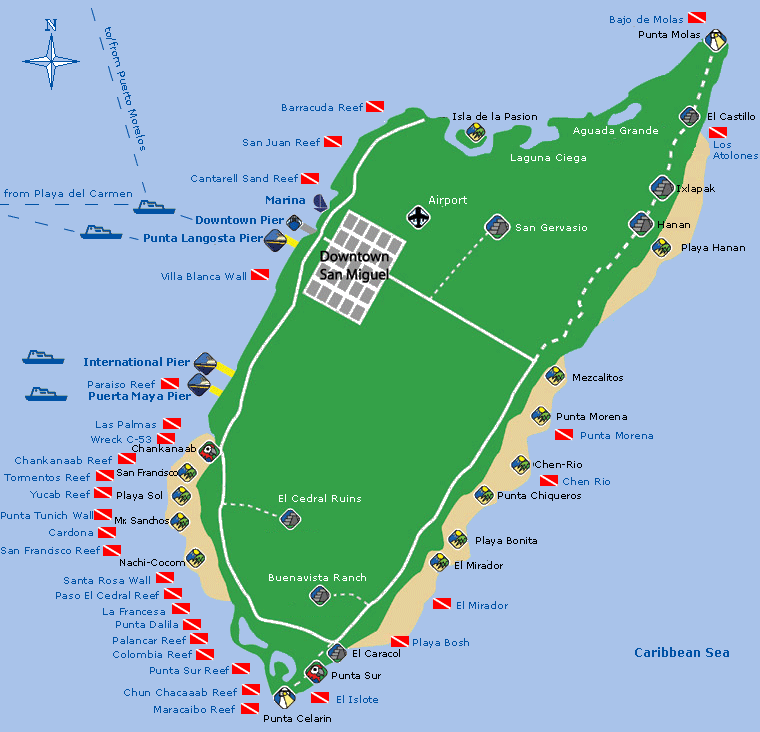
Playa Bonita: toch maar de strandstoelen binnenzetten? Dit mooie strand aan de noord-oost kant van het eiland zal na afloop amper meer te herkennen zijn.
Overzicht van het snorkelparadijs. De orkaan zal ook veel schade brengen aan de koraalriffen in het noorden en uiterste zuiden.
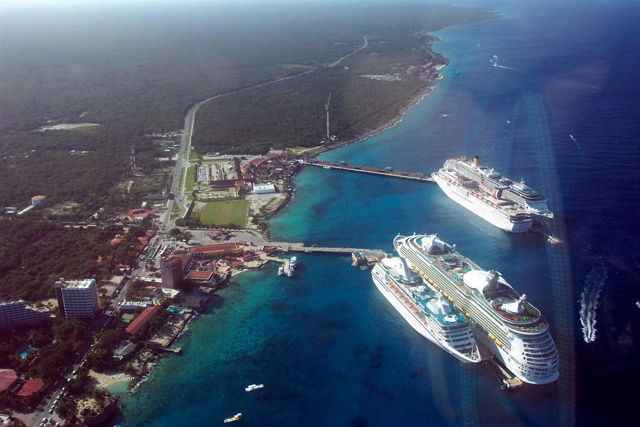
Deze grote cruiseschepen zullen nu wel elders zijn. Straks mogen ze ingezet worden voor hulptransporten.
Doe mee met het voorspellen van het weer!
Weekvoorspelling | Week 12 (invullen tot 16-03 - 11:59)
Maandvoorspelling Maart (Inzendingen gesloten)
Jaarvoorspelling 2025 / 2026
Weekvoorspelling | Week 12 (invullen tot 16-03 - 11:59)
Maandvoorspelling Maart (Inzendingen gesloten)
Jaarvoorspelling 2025 / 2026
De eerste schade zal wel binnen zijn, damn dat eilandje krijg dat te voorduren!

Doe mee met het voorspellen van het weer!
Weekvoorspelling | Week 12 (invullen tot 16-03 - 11:59)
Maandvoorspelling Maart (Inzendingen gesloten)
Jaarvoorspelling 2025 / 2026
Weekvoorspelling | Week 12 (invullen tot 16-03 - 11:59)
Maandvoorspelling Maart (Inzendingen gesloten)
Jaarvoorspelling 2025 / 2026

Het leek er toch eerst op dat ie de Yucatán zou missen?quote:Op vrijdag 21 oktober 2005 18:36 schreef SpeedyGJ het volgende:
De eerste schade zal wel binnen zijn, damn dat eilandje krijg dat te voorduren!
[afbeelding]
-Black_Tulip-
[KNE]-Mod
"missen" is ook behoorlijk relatief gezien. Niet de volle laag krijgen is wat anders. Nu krijgen ze wel de volle laag in ieder geval.quote:Op vrijdag 21 oktober 2005 20:30 schreef ThE_ED het volgende:
[..]
Het leek er toch eerst op dat ie de Yucatán zou missen?
-Black_Tulip-
Locatie: Gorinchem
Mors principium est
Mors principium est