TRV Travel
Alles over je favoriete vakantiebestemmingen, vakantie-ervaringen van jezelf en anderen, tips, info en meer. Van Schin op Geul tot de USA.


Deeltje 2 van dit interessante onderwerp
Deel 1
Bizarre eilanden
Paar leuke eilanden uit deel 1:
[ Bericht 0% gewijzigd door Leffe48 op 28-08-2005 16:13:21 ]
Deel 1
Bizarre eilanden
Paar leuke eilanden uit deel 1:
quote:Op dinsdag 31 mei 2005 00:19 schreef Apekoek het volgende:
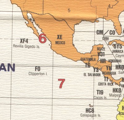
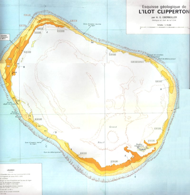
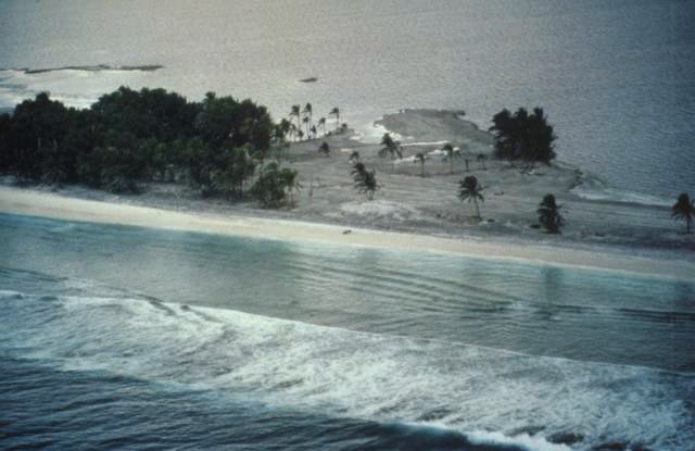
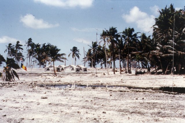
De meest bizarre eilanden in de wereld, TS trapt af met Clipperton Island, het valt onder de Franse vlag en ligt links van Mexico:
Het groene is land, en het witte is een soort van een meer, het eiland bestaat dus slechts uit een ring van strand.
Zee en meer aan de andere kant
Het eiland is dus onbewoond en wordt slechts bezocht door wetenschappers van verschillende nationaliteiten.
Voeg zelf bizarre eilanden toe, met informatie over waar het ligt, eventueel welk land, en foto's
quote:Op dinsdag 31 mei 2005 00:40 schreef Allan24 het volgende:
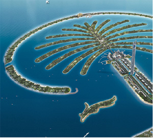
Bij Dubai (Verenigde Arabische Emiraten) ligt in de Arabische Golf twee kunstmatig aangelegde eilanden, 'The Palm Islands'.
Door met baggerschuiten zand van de bodem op te zuigen en op te spuiten creërt een (volgens mij gedeeltelijk Nederlands) bedrijf hier een aantal palmboomvormige eilanden in zee, waarop dure villa's en luxe hotels worden gebouwd.
Op vergelijkbare wijze heb je, ook in Dubai: 'The World Islands':
Vanaf ± US$ 7 miljoen kun je je eigen stukje 'aarde' kopen.
(Overigens gaat in Dubai tevens het hoogste gebouw ter wereld gebouwd worden, de Burj Dubai, met 705 meter ( !) ruim hoger dan de Taipei 101 toren in Taiwan:)


quote:Op woensdag 1 juni 2005 15:49 schreef LibertarianX het volgende:
hoge resolutie sat foto http://www.gesource.ac.uk/highres/hires_1936.jpg
Het was een vulkaan eiland, dat ontplofte, de grootste explosie die de mensheid de laatste 2500 jaar heeft meegemaakt waarschijnlijk, en sindsdien nog steeds actief als vulkaan. Er is een nieuw eiland ontstaan, Anak Krakatau (kind van krakatau) en die vulkaa groeit nog steeds.


quote:


quote:Op woensdag 8 juni 2005 01:02 schreef Allan24 het volgende:
Blijft een leuk topic, dit!
Een toevoeging:
Perejil
Spanje stuurt in juli 2002 marineschepen (fregatten, korvetten en zelfs een onderzeeër) en troepen naar de Afrikaanse kust naar aanleiding van de bezetting van het Peterselie-eiland in de Middellandse Zee door Marokko.
De crisis tussen beide landen begon toen enkele Marokkaanse militairen voet aan wal zetten op Peterselie-eiland en er de Marokkaanse vlag hesen. Het onbewoonde eilandje ligt 200 meter voor de Marokkaanse kust en is niet meer dan een rotspartij van enkele voetbalvelden groot.
Niettemin neemt Spanje de bezetting van het eilandje hoog op en eist dat Marokko direct vertrekt. Spanje geeft overigens toe dat de internationale status van Peterselie-eiland niet geheel duidelijk is. In de overeenkomst die de nabijgelegen enclave Ceuta een autonome (Spaanse) status geeft, wordt Peterselie-eiland niet met name genoemd. Rabat op zijn beurt zegt dat Peterselie-eiland sinds de onafhankelijkheid van 1956 onderdeel is van Marokko.

quote:Op zondag 12 juni 2005 14:36 schreef Karina het volgende:
Bikini
Vooral bekend vanwege de atoomproeven in de jaren '40 en '50 en naamgever aan de bikini natuurlijk.
[..]

quote:Op donderdag 30 juni 2005 02:26 schreef Mute_Me het volgende:
Niet echt bizar, maar leuk om eens uit te lichten aangezien veel internetters het kennen.
Tokelau
Bekend van de (gratis) domeinnaam .tk (http://www.dot.tk)
Het is een land dat bestaat uit 3 eilanden gelegen in Oceania.
Originally settled by Polynesian emigrants from surrounding island groups, the Tokelau Islands were made a British protectorate in 1889. They were transferred to New Zealand administration in 1925.
Geographic coordinates: 9 00 S, 172 00 W
total: 10 sq km
land: 10 sq km
water: 0 sq km
Climate: Tropical; moderated by trade winds (April to November)
Geography - note: consists of three atolls, each with a lagoon surrounded by a number of reef-bound islets of varying length and rising to over three meters above sea level
Population: 1,405
Age structure:
0-14 years: 42%
15-64 years: 53%
65 years and over: 5%
Languages: Tokelauan (a Polynesian language), English
Tokelau's small size (three villages), isolation, and lack of resources greatly restrain economic development and confine agriculture to the subsistence level. The people rely heavily on aid from New Zealand - about $4 million annually - to maintain public services, with annual aid being substantially greater than GDP. The principal sources of revenue come from sales of copra, postage stamps, souvenir coins, and handicrafts. Money is also remitted to families from relatives in New Zealand.
Telephones - main lines in use: 300
Telephones - mobile cellular: 0
Airports: none; lagoon landings are possible by amphibious aircraft (2004 est.)


[ Bericht 0% gewijzigd door Leffe48 op 28-08-2005 16:13:21 ]
Quidquid latine dictum sit, altum videtur.
Interesante OP!!
Experience is what you get when you don't get what you wanted
Take my advice ... I don't use it anyway...
Een goede Fok! Search
Een goede Fok! Search
Take my advice ... I don't use it anyway...
Een goede Fok! Search
Een goede Fok! Search
Eigenlijk ook bijzar: Het Indonesische eiland Java.
Het eiland is zo'n 130.000 km2 groot en er wonen nu zo'n 160 miljoen mensen naar het schijnt. Dat is zo'n 1230 per km2. Dat is zeer dicht bevolkt, maar als je er bent geweest weet je dat er vele gebieden zijn waar vrijwel niemand woont.
Het eiland is zo'n 130.000 km2 groot en er wonen nu zo'n 160 miljoen mensen naar het schijnt. Dat is zo'n 1230 per km2. Dat is zeer dicht bevolkt, maar als je er bent geweest weet je dat er vele gebieden zijn waar vrijwel niemand woont.

Bouvet Island is ook vrij bizar:
http://en.wikipedia.org/wiki/Bouvet_Island
misschien wel het meest afgelegen stukje land op aarde waar in de jaren 70 door een onbekende partij een atoomproef is gedaan
http://en.wikipedia.org/wiki/Bouvet_Island
misschien wel het meest afgelegen stukje land op aarde waar in de jaren 70 door een onbekende partij een atoomproef is gedaan
We cross our bridges when we come to them and burn them behind us, with nothing to show for our progress except a memory of the smell of smoke, and a presumption that once our eyes watered.
Van de wikipedia site:quote:Op zondag 28 augustus 2005 16:13 schreef Flurry het volgende:
Bouvet Island is ook vrij bizar:
http://en.wikipedia.org/wiki/Bouvet_Island
misschien wel het meest afgelegen stukje land op aarde waar in de jaren 70 door een onbekende partij een atoomproef is gedaan
"In 1964, an abandoned lifeboat was discovered on the island, along with various supplies; however, the lifeboat's passengers were never found."
Idd strange en dat van die atoomproef is helemaal bizar
Love's like crapping your pants: everyone around you notices, but only you have that warm feeling inside
Leuk topic.
Pampus vind ik ook wel een raar eiland.
Voor de liefhebber: http://www.pampus.nl/
[ Bericht 65% gewijzigd door Dirman op 30-08-2005 01:00:18 ]
Pampus vind ik ook wel een raar eiland.

Voor de liefhebber: http://www.pampus.nl/
[ Bericht 65% gewijzigd door Dirman op 30-08-2005 01:00:18 ]

TVP
Op maandag 9 november 2009 12:25 schreef Whiskey_Tango het volgende:
Dat interesseert GroenLinks voor geen meter, ze zien je als een wandelende zak euro's waar ze handig een tap in kunnen drukken voor hun socialistische hobbies.
Dat interesseert GroenLinks voor geen meter, ze zien je als een wandelende zak euro's waar ze handig een tap in kunnen drukken voor hun socialistische hobbies.
deeltje 2 van mn topic alweer
marru jongens! Deze eilanden (dan bedoel ik met name de nieuwe reacties) zijn al voorbij gekomen in deeltje 1.
marru jongens! Deze eilanden (dan bedoel ik met name de nieuwe reacties) zijn al voorbij gekomen in deeltje 1.
ze stonden niet in de OPquote:Op woensdag 31 augustus 2005 01:49 schreef Apekoek het volgende:
deeltje 2 van mn topic alweer
marru jongens! Deze eilanden (dan bedoel ik met name de nieuwe reacties) zijn al voorbij gekomen in deeltje 1.
We cross our bridges when we come to them and burn them behind us, with nothing to show for our progress except a memory of the smell of smoke, and a presumption that once our eyes watered.
Het eiland Chrissi. Ligt op 45 minuten varen van Ierapetra[Kreta].
[ Bericht 2% gewijzigd door FrisianReds op 31-08-2005 21:08:05 ]
quote:One of the 81 uninhabited islands of Crete is Chrissi or Gaidouronisi(donkey) island. The residents of Ierapetra call it 'the Island', as there is a special relationship between them.
Chrissi lies 8 miles away from Ierapetra's coasts, in the Libyan sea. Chrissi is almost flat with colorful volcanic rocks covered in gold sand, purple shells and sand dunes.
It is 5 kms long and its average width is 1 km. Its average height is 10m. The highest hill is on the eastern part and is called "Kefala", 31m high. From the top of this hill you can see the amazing view of the Lebanon cedar forest, probably the last one left in Europe. The density of these trees is approx. 28 trees per hectare and in an average age of 200 years old.
On the western part of the island the visitor can see the well preserved old chapel of Agios Nikolaos (possibly built in the 13th century), the salt pan which still gathers salt, the old port, the Minoan ruins, some Roman carved graves and the light house.
At the Byzantine era the main source of income was fishing, salt export and the export of "porfira", a scarlet dye produced from shells for the cloads of Europe's royalty.
Later pirates forced the inhabitants to flee Chrissi for safety in Crete and used the island as a hide-out. Many pirate and merchant ships have sunk in the area.
In the sea around the island the variety of the marine species is impressive. Around 54 different species of fossils were set on the volcanic rocks many years ago, when Chrissi was covered by water. A number of them still lives in the sea around. As a result all the northern coasts (Belegrina, Hatzivolakas & Kataprosopo bays) are full of shells.
The turquoise waters around the island are shallow. Up to 1 Km north and south, the depth does not exceed 10 m. This makes Chrissi the best place for snorkeling.
Chrissi looks like paradise on earth. A place to dream, swim and go walking.
About 700 m east of Chrissi is a small rocky island "Mikronisi". On Mikronisi hundreds of herring seagulls make their nests. For the well preserved rare ecosystem and its beauty, Chrissi is protected as an " Area of Intense Natural Beauty".
From the middle of May till late October there are excursions to the island daily. The departure is from Ierapetra at 10.30 a.m. and the return is around 16.00 p.m. The duration of the voyage is about one 50 min. (depending on the weather).
Passengers disembark at "Vougiou Mati" on the south part, where there is a tavern. From the tavern there is a path along the southern beach. Turning north, it leads to the eastern side of "Belegrina" bay (shells beach).
Within a day trip the visitor has enough time to walk around, swim in its turquoise waters and have a snack at the tavern.
In the unspoiled and fragile environment of Chrissi visitors must act with utmost respect towards nature. It is not allowed to litter, to collect rocks, shells, plants, to light fire, to walk outside the designated paths and to camp.


[ Bericht 2% gewijzigd door FrisianReds op 31-08-2005 21:08:05 ]
Are you watching Paul Scholes!
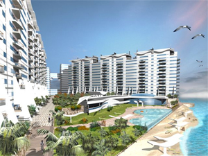
Guadeloupe
Dit eiland is een provincie van Frankrijk gelegen in het caribische gebied. Het is dus niet onafhankelijk maar gewoon een stuk Frankrijk in de caribische zee. (Niet zoals de Nederlandse Antillen want daar heeft men een eigen nationaliteit en een status van een onafhankelijkland)Er worden dus Franse wetten gebruikt en gewoon met de euro betaald.
De vlag van het eiland, of beter gezegd de vlag van de provincie die lijkt op die van Suriname.
Kaartjes
Welkom in Frankrijk.

Dit eiland is een provincie van Frankrijk gelegen in het caribische gebied. Het is dus niet onafhankelijk maar gewoon een stuk Frankrijk in de caribische zee. (Niet zoals de Nederlandse Antillen want daar heeft men een eigen nationaliteit en een status van een onafhankelijkland)Er worden dus Franse wetten gebruikt en gewoon met de euro betaald.
De vlag van het eiland, of beter gezegd de vlag van de provincie die lijkt op die van Suriname.

Kaartjes


Welkom in Frankrijk.

Bijzonder tussen kreta en Afrika in dusquote:Op woensdag 31 augustus 2005 20:58 schreef FrisianReds het volgende:
Het eiland Chrissi. Ligt op 45 minuten varen van Ierapetra[Kreta].
[..]
[afbeelding]
[afbeelding]
[afbeelding]

Hans Eiland
Ik kan me niet herinneren dat dit eiland al aan bod is gekomen in het vorige deel, dus voeg ik hem even toe. Hans Eiland is op het eerste gezicht een nietsbetekenend klein pokke-eiland tussen Groenland en Canada, maar het interessante aan deze rotsmassa die boven het water uitsteekt is dat de soevereiniteit erover wordt betwist door Canada en Denemarken (Groenland), net zoals het eilandje Rockall in de Noordzee wordt betwist door Denemarken (Faeroër), IJsland en Ierland. De kwestie bestaat al enkele decennia, maar recentelijk laaide het enthausiasme weer op en werd er zelfs een internetoorlog over gevochten tussen Denen en Canadezen. Maar goed, de geïnteresseerden verwijs ik naar het engelstalige wikipedia-artikel over het eiland: http://en.wikipedia.org/wiki/Hans_Island

Ik kan me niet herinneren dat dit eiland al aan bod is gekomen in het vorige deel, dus voeg ik hem even toe. Hans Eiland is op het eerste gezicht een nietsbetekenend klein pokke-eiland tussen Groenland en Canada, maar het interessante aan deze rotsmassa die boven het water uitsteekt is dat de soevereiniteit erover wordt betwist door Canada en Denemarken (Groenland), net zoals het eilandje Rockall in de Noordzee wordt betwist door Denemarken (Faeroër), IJsland en Ierland. De kwestie bestaat al enkele decennia, maar recentelijk laaide het enthausiasme weer op en werd er zelfs een internetoorlog over gevochten tussen Denen en Canadezen. Maar goed, de geïnteresseerden verwijs ik naar het engelstalige wikipedia-artikel over het eiland: http://en.wikipedia.org/wiki/Hans_Island
Gelegenheidssedevacantist extraordinaire. Een dozijn lama's en je grootvader. Tweede Exloërmond, ofwel het vagevuur. De schemerlamp van je nachtmerries. Vla, en veel ervan. Verlanglijst: vijf pedaalemmers en het einde der tijden.
hehe, mn broer heeft die eilanden in Dubai 'zelf' gebouwd. There's more to come!!
It is your friends who make your world!
Misschien al aan bod gekomen in het vorige deel plús schaamteloze crosspost:
Het eilandje Pitcairn is vooral bekend door het feit dat de originele inwoners opvarenden waren van HMS Bounty die waren gaan muiten tegen hun gezagvoerder. Dit verhaal is opgetekend in het boek Muiterij op de Bounty en is later verschillende malen verfilmd.
In 1790 voeren een zevental muiters hun boot van Tahiti naar Pitcairn en namen een aantal Tahitiaanse vrouwen mee. Ze vestigden zicht op het eiland. In 1856 woonden haast 200 mensen op Pitcairn en verliet de totale bevolking het eiland uit eigen wil. Een veertigtal van hen keerde enkele jaren later echter terug. Pitcairn zat al die tijd, en tot vandaag, onder de Britse kroon.
Pitcairn is het minst bevolkte land ter wereld met minder dan 50 inwoners in 9 families. Zij wonen op ongeveer 46km2
Het is één van de meest afgelegen plaatsen ter wereld, 5.300 kilometer van het dichtstbijzijnde vasteland. Er komt géén vliegtuig en slechts drie maal per jaar een schip uit Nieuw-Zeeland. Er is één winkel, maar die doet maar drie maal weeks open. Het belangrijkste "evenement" is ongetwijfeld de zaterdagmis. De verjaardag van een eilander is ook reden genoeg om samen te vieren.
In 2004 werden overigens zeven mannelijke bewoners van het eiland aangeklaagd voor 55 zaken van seksueel misbruik en verkrachting van vrouwen en meisjes, waarvan sommige niet ouder dan 11 jaar. Zes van de zeven werden schuldig bevonden. Vier kregen celstraffen van twee tot zes jaar, speciaal hiervoor zijn cellen gebouwd op het eiland. De oudste verdachte mag zijn celstraf thuis uitzitten. Twee mannen kregen taakstraffen. De rechters hadden bij de strafbepaling er rekening meegehouden dat zware straffen een nadelig effect zouden hebben op de gemeenschap, aangezien de mannen op Pitcairn de boten bedienen waarmee de voorraden voor het eiland ingeladen worden.
Bronnen: http://www.cia.gov/cia/publications/factbook/geos/pc.html, wikipedia en http://www.government.pn/
Een volslagen maf eiland. "Vol" maffe mensen met een bijzonder verleden. Volgens mij is Büch er wel eens geweest op één van zijn eilandenreizen. Ik zou er ontzettend graag eens een kijkje nemen.


Snobs have more fun!
KLIK!
KLIK!
Dit zijn overigens wel meer gebieden, Frans Guyana is ook EU gebied en een departement van Frankrijk. Je kunt ze op je euro biljetten wel zien.quote:Op dinsdag 1 november 2005 11:28 schreef Apekoek het volgende:
Guadeloupe[afbeelding]
Dit eiland is een provincie van Frankrijk gelegen in het caribische gebied. Het is dus niet onafhankelijk maar gewoon een stuk Frankrijk in de caribische zee. (Niet zoals de Nederlandse Antillen want daar heeft men een eigen nationaliteit en een status van een onafhankelijkland)Er worden dus Franse wetten gebruikt en gewoon met de euro betaald.
De vlag van het eiland, of beter gezegd de vlag van de provincie die lijkt op die van Suriname.
[afbeelding]
Kaartjes
[afbeelding]
[afbeelding]
[afbeelding]
Welkom in Frankrijk.
[afbeelding]

Bouvet is inderdaad een grappig eilandje. De proef zou in 1979 door waarschijnlijk Israël, Taiwan of Zuid Afrika gedaan zijn.quote:Op zondag 28 augustus 2005 16:13 schreef Flurry het volgende:
Bouvet Island is ook vrij bizar:
http://en.wikipedia.org/wiki/Bouvet_Island
misschien wel het meest afgelegen stukje land op aarde waar in de jaren 70 door een onbekende partij een atoomproef is gedaan
De Wikipedia meld overigens ook al dat de serie Lost een relatie heeft met dit eilandje. Iets wat gezien de foto's van het eiland (ijs en sneeuw) niet helemaal klopt met de locatie van Lost (tropisch paradijs)
Katelorizo... Ro en Strgyli
.
3 piepkleine eilandjes voor de turkse kust... die wel bij Griekenland horen.
Het is het meest oostelijke puntje van Griekenland...
.
3 piepkleine eilandjes voor de turkse kust... die wel bij Griekenland horen.
Het is het meest oostelijke puntje van Griekenland...


Suomenlinna, een partij rotseilandjes voor de kust van Helsinki. Zijn met elkaar verbonden en er is een fort op gebouwd (bescherming tegen de Russen volgens mij), er zijn dus veel bunkers, kanonnen en barakken. (meesten op het voorste eilandje op de foto)
Je kan er geweldig wandelen want je kijkt zo de Baltic op. Ook gaat er een ov naar toe, je kan gewoon met een pondje wat ong. 15minuten duurt.
Er wonen heden nog steeds mensen op Suomenlinna en het staat inmiddels op de UNESCO lijst van world heritage!
The black and white you'll never pass, stick yer blue flag up yer arse!
'They know on the Continent that European football without the English is like a hot dog without the mustard' Sir Bobby Charlton
'They know on the Continent that European football without the English is like a hot dog without the mustard' Sir Bobby Charlton
|
|