W&T Wetenschap & Technologie
Een plek om te discussiëren over wetenschappelijke onderwerpen, wetenschappelijke problemen, technologische projecten en grootse uitvindingen.


1 Jaar later... En de rovers maken nog altijd mooie kiekjes van het Mars opporvlakte
http://forum.fok.nl/showtopic.php/441416 DEEL 1
http://forum.fok.nl/showtopic.php/457865 DEEL 2
http://forum.fok.nl/showtopic.php/473850 DEEL 3
http://forum.fok.nl/showtopic.php/491165 DEEL 4
Inmiddels is Opportunity bezig bij het hitteschild
En Spirit is ook nog druk bezig
Nog altijd ...GEEN gelul over Marspiramides en groene mannetjes...
En ook niet over VALSE kleuren.
Daarvoor is in The Truth is in Here... plaats genoeg.
Screensaver (Updates latest photos)
Presskit (PDF format)
Een handige Mars Tijd Aplicatie
Info over de Mars Rover(s)
Raw Images For Spirit and Opportunity
NASA TV Live Stream
AKTUELE en andere Ruimtevaart/Astronomie links
[Centraal] Cassini-Huygens missie // Saturnus in de picture
[Centraal] Ruimtevaart
[Centraal] Astronomie
MR. Lunks hideout
(Freeware) Programma's voor Ruimtevaart/Astronomie
Starry Night is geen freeware... Maar mag niet ontbreken
Celestia Home Page & Spacecraft and Astronomical updates for Celestia
Wil je zelf in een ruimteschip rondvliegen en de planeten bezoeken?
Of wil je liever een kijkje nemen bij andere sterren, zelfs bij exoplaneten?
Het is allemaal mogelijk met Celestia.
Een prachtig programma met een realistische weergave van objecten.
Winorbit Home Page
Wanneer komt een bepaalde satelliet over de aarde?
Dat kun je voorspellen met dit mooie programma.
Je kunt zelfs je eigen woonplaats opgeven en dan voorspelt het programma
wanneer er een heldere satelliet zal opflitsen. Handig en snel.
Colliding Galaxies
Software to simulate interacting galaxies.
Gravity3D 1.5 (441 KB)
Gravity3D simulates the gravitational interaction between galaxies as they collide.
It uses the gravity equation F=G*M1*M2/R^2 and assumes that orbiting stars have
negligible mass compared to the parent stars/black holes.
This software renders hundreds of thousands of stars in realtime.
Stars 1.2
Stars is een planetarium programma waarmee handige zoekkaartje
af te drukken zijn om dat ene melkwegstelsel of sterrenhoop aan de hemel op te zoeken.
En daarna met een telescoop te bewonderen
Starcalc Home Page
Ga je vanavond zelf in je eigen tuin waarnemen?
Print dan een mooie sterrenkaart waarop alle sterren staan die er die avond te zien zullen zijn.
De sterrenkaart bevat alle 110 messier objecten en vele sterren
(ook degene die niet met het oog zichtbaar zijn).
[ Bericht 4% gewijzigd door -CRASH- op 13-01-2005 18:13:05 ]
http://forum.fok.nl/showtopic.php/441416 DEEL 1
http://forum.fok.nl/showtopic.php/457865 DEEL 2
http://forum.fok.nl/showtopic.php/473850 DEEL 3
http://forum.fok.nl/showtopic.php/491165 DEEL 4
Inmiddels is Opportunity bezig bij het hitteschild

En Spirit is ook nog druk bezig

Nog altijd ...GEEN gelul over Marspiramides en groene mannetjes...
En ook niet over VALSE kleuren.
Daarvoor is in The Truth is in Here... plaats genoeg.
Screensaver (Updates latest photos)
Presskit (PDF format)
Een handige Mars Tijd Aplicatie
Info over de Mars Rover(s)
Raw Images For Spirit and Opportunity
NASA TV Live Stream
AKTUELE en andere Ruimtevaart/Astronomie links
[Centraal] Cassini-Huygens missie // Saturnus in de picture
[Centraal] Ruimtevaart
[Centraal] Astronomie
MR. Lunks hideout
(Freeware) Programma's voor Ruimtevaart/Astronomie
Starry Night is geen freeware... Maar mag niet ontbreken
Celestia Home Page & Spacecraft and Astronomical updates for Celestia
Wil je zelf in een ruimteschip rondvliegen en de planeten bezoeken?
Of wil je liever een kijkje nemen bij andere sterren, zelfs bij exoplaneten?
Het is allemaal mogelijk met Celestia.
Een prachtig programma met een realistische weergave van objecten.
Winorbit Home Page
Wanneer komt een bepaalde satelliet over de aarde?
Dat kun je voorspellen met dit mooie programma.
Je kunt zelfs je eigen woonplaats opgeven en dan voorspelt het programma
wanneer er een heldere satelliet zal opflitsen. Handig en snel.
Colliding Galaxies
Software to simulate interacting galaxies.
Gravity3D 1.5 (441 KB)
Gravity3D simulates the gravitational interaction between galaxies as they collide.
It uses the gravity equation F=G*M1*M2/R^2 and assumes that orbiting stars have
negligible mass compared to the parent stars/black holes.
This software renders hundreds of thousands of stars in realtime.
Stars 1.2
Stars is een planetarium programma waarmee handige zoekkaartje
af te drukken zijn om dat ene melkwegstelsel of sterrenhoop aan de hemel op te zoeken.
En daarna met een telescoop te bewonderen
Starcalc Home Page
Ga je vanavond zelf in je eigen tuin waarnemen?
Print dan een mooie sterrenkaart waarop alle sterren staan die er die avond te zien zullen zijn.
De sterrenkaart bevat alle 110 messier objecten en vele sterren
(ook degene die niet met het oog zichtbaar zijn).
[ Bericht 4% gewijzigd door -CRASH- op 13-01-2005 18:13:05 ]
<a href="http://www.vwkweb.nl/" rel="nofollow" target="_blank">[b]Vereniging voor weerkunde en klimatologie[/b]</a>
<a href="http://www.estofex.org/" rel="nofollow" target="_blank">[b]ESTOFEX[/b]</a>
<a href="http://www.estofex.org/" rel="nofollow" target="_blank">[b]ESTOFEX[/b]</a>
Opportunity's Heat Shield in Color, Sol 335
Medium Image (83.3 KB)
Large Image (1.3 MB)
This image from the panoramic camera on NASA's Mars Exploration Rover Opportunity features the remains of the heat shield that protected the rover from temperatures of up to 2,000 degrees Fahrenheit as it made its way through the martian atmosphere. This two-frame mosaic was taken on the rover's 335th martian day, or sol, (Jan. 2, 2004).
The view is of the main heat shield debris seen from approximately 10 meters (about 33 feet) away from it. Many rover-team engineers were taken aback when they realized the heat shield had inverted, or turned itself inside out. The height of the pictured debris is about 1.3 meters (about 4.3 feet). The original diameter was 2.65 meters (8.7 feet), though it has obviously been deformed. The Sun reflecting off of the aluminum structure accounts for the vertical blurs in the picture.
Opportunity's Heat Shield in Color, Sol 325
This image from the panoramic camera on NASA's Mars Exploration Rover Opportunity shows remains of the heat shield that protected the spacecraft as it barreled through the martian atmosphere. The image was taken on the rover's 325th martian day, or sol, (Dec. 22, 2004).
[ Bericht 1% gewijzigd door -CRASH- op 13-01-2005 05:26:28 ]
Medium Image (83.3 KB)
Large Image (1.3 MB)

This image from the panoramic camera on NASA's Mars Exploration Rover Opportunity features the remains of the heat shield that protected the rover from temperatures of up to 2,000 degrees Fahrenheit as it made its way through the martian atmosphere. This two-frame mosaic was taken on the rover's 335th martian day, or sol, (Jan. 2, 2004).
The view is of the main heat shield debris seen from approximately 10 meters (about 33 feet) away from it. Many rover-team engineers were taken aback when they realized the heat shield had inverted, or turned itself inside out. The height of the pictured debris is about 1.3 meters (about 4.3 feet). The original diameter was 2.65 meters (8.7 feet), though it has obviously been deformed. The Sun reflecting off of the aluminum structure accounts for the vertical blurs in the picture.
Opportunity's Heat Shield in Color, Sol 325

This image from the panoramic camera on NASA's Mars Exploration Rover Opportunity shows remains of the heat shield that protected the spacecraft as it barreled through the martian atmosphere. The image was taken on the rover's 325th martian day, or sol, (Dec. 22, 2004).
[ Bericht 1% gewijzigd door -CRASH- op 13-01-2005 05:26:28 ]
<a href="http://www.vwkweb.nl/" rel="nofollow" target="_blank">[b]Vereniging voor weerkunde en klimatologie[/b]</a>
<a href="http://www.estofex.org/" rel="nofollow" target="_blank">[b]ESTOFEX[/b]</a>
<a href="http://www.estofex.org/" rel="nofollow" target="_blank">[b]ESTOFEX[/b]</a>
* Marvin-THE-MARTiAN = present !!quote:Op donderdag 13 januari 2005 10:25 schreef Doffy het volgende:
* bookmark *
@ Crash & Marvin: voor deze meesterlijke topicserie!

En weer verder... (kom zo nog wel met een intelligete posts, maar eerst effe inlezen in wat ik afgelopen week wel niet gemist heb... )
"Mijn" fotoalbum...
-->creationisme _O- --> http://en.wikipedia.org/wiki/Panspermia *O* evolutie & Darwin O+
-->
Hey... die Marv
[ Bericht 56% gewijzigd door -CRASH- op 15-01-2005 02:31:58 ]
[ Bericht 56% gewijzigd door -CRASH- op 15-01-2005 02:31:58 ]
<a href="http://www.vwkweb.nl/" rel="nofollow" target="_blank">[b]Vereniging voor weerkunde en klimatologie[/b]</a>
<a href="http://www.estofex.org/" rel="nofollow" target="_blank">[b]ESTOFEX[/b]</a>
<a href="http://www.estofex.org/" rel="nofollow" target="_blank">[b]ESTOFEX[/b]</a>
Ik hou het erop dat het een meteoriet is.
De steen of ijzer meteoriet is veel gladder en heeft dumpels die je ook
in andere meteorieten ziet.
Ben benieuwd wat de Microscopic Imager voor moois laat zien.
De steen of ijzer meteoriet is veel gladder en heeft dumpels die je ook
in andere meteorieten ziet.

Ben benieuwd wat de Microscopic Imager voor moois laat zien.

<a href="http://www.vwkweb.nl/" rel="nofollow" target="_blank">[b]Vereniging voor weerkunde en klimatologie[/b]</a>
<a href="http://www.estofex.org/" rel="nofollow" target="_blank">[b]ESTOFEX[/b]</a>
<a href="http://www.estofex.org/" rel="nofollow" target="_blank">[b]ESTOFEX[/b]</a>
* -CRASH- geeft zichzelf een schouderklopje
Iron Meteorite on Mars
NASA's Mars Exploration Rover Opportunity has found an iron meteorite on Mars, the first meteorite of any type ever identified on another planet. The pitted, basketball-size object is mostly made of iron and nickel. Readings from spectrometers on the rover determined that composition. Opportunity used its panoramic camera to take the images used in this approximately true-color composite on the rover's 339th martian day, or sol (Jan. 6, 2005). This composite combines images taken through the panoramic camera's 600-nanometer (red), 530-nanometer (green), and 480-nanometer (blue) filters.
Image credit: NASA/JPL/Cornell
quote:-CRASH- - donderdag 6 januari 2005 @ 01:51
Mmmmm... lijkt geen "normale" steen te zijn.
Lijkt verdacht veel op een meteoriet.. "We shall see"
Iron Meteorite on Mars

NASA's Mars Exploration Rover Opportunity has found an iron meteorite on Mars, the first meteorite of any type ever identified on another planet. The pitted, basketball-size object is mostly made of iron and nickel. Readings from spectrometers on the rover determined that composition. Opportunity used its panoramic camera to take the images used in this approximately true-color composite on the rover's 339th martian day, or sol (Jan. 6, 2005). This composite combines images taken through the panoramic camera's 600-nanometer (red), 530-nanometer (green), and 480-nanometer (blue) filters.
Image credit: NASA/JPL/Cornell
<a href="http://www.vwkweb.nl/" rel="nofollow" target="_blank">[b]Vereniging voor weerkunde en klimatologie[/b]</a>
<a href="http://www.estofex.org/" rel="nofollow" target="_blank">[b]ESTOFEX[/b]</a>
<a href="http://www.estofex.org/" rel="nofollow" target="_blank">[b]ESTOFEX[/b]</a>
* Marvin-THE-MARTiAN geeft -CRASH- een schouderklopje houd ons op de hoogte over de meteoriet!!quote:Op donderdag 20 januari 2005 12:33 schreef -CRASH- het volgende:
* -CRASH- geeft zichzelf een schouderklopje
"Mijn" fotoalbum...
-->creationisme _O- --> http://en.wikipedia.org/wiki/Panspermia *O* evolutie & Darwin O+
-->
In de wetenschap dat Raketgeleerden de Nationale IQ-test gewonnen hebben, wordt dit topic ook weer door ondergetekende gevolgd.
Slechtste tvp ooit
Slechtste tvp ooit
[oftopic dan maar]quote:Op donderdag 20 januari 2005 17:19 schreef pfaf het volgende:
In de wetenschap dat Raketgeleerden de Nationale IQ-test gewonnen hebben, wordt dit topic ook weer door ondergetekende gevolgd.
Slechtste tvp ooit
yup gemiddeld 117, ik scoorde volgens BNN 125 dus mag mezelf er nog steeds toe rekenen. *pfieuh*
[/oftopic dan maar]
"Mijn" fotoalbum...
-->creationisme _O- --> http://en.wikipedia.org/wiki/Panspermia *O* evolutie & Darwin O+
-->
Ik zal maar weer eens een lading pics plaatsen welke ikzelf wel aardig vond van afgelopen tijd en welke nog niet voorbij gekomen waren...
PS als je gewoon op de pics klikt krijg je de "large" versie te zien in een ander scherm.

quote:3 jan 2005
Spirit View of 'Wishstone' (False Color)
Scientists working with NASA's Mars Exploration Rover Spirit decided to examine this rock, dubbed "Wishstone," based on data from the miniature thermal emission spectrometer. That instrument's data indicated that the mineralogy of the rocks in this area is different from that of rocks encountered either on the plains of Gusev Crater or in bedrock outcrops examined so far in the "Columbia Hills" inside the crater. Spirit used its rock abrasion tool first to scour a patch of the rock's surface with a wire brush, then to grind away the surface to reveal interior material. Placement of the rover's alpha particle X-ray spectrometer on the exposed circle of interior material revealed that the rock is rich in phosphorus. Spirit used its panoramic camera during the rover's 342nd martian day, or sol, (Dec. 18, 2004) to take the three individual images that were combined to produce this false-color view emphasizing the freshly ground dust around the hole cut by the rock abrasion tool.
Image credit: NASA/JPL/Cornell

quote:12 jan 2005
Meandering Tracks on "Husband Hill"
This 360-degree panorama of a section of the "Columbia Hills" shows meandering, crisscrossing wheel tracks that NASA's Mars Exploration Rover Spirit left behind while using its scientific instruments to analyze a new class of rocks in Gusev Crater on Mars. Because Spirit has been experiencing a high rate of slip on the sandy, sloped terrain on this flank of "Husband Hill," scientists are directing the rover to check its progress often to avoid getting a rock stuck in one of its wheel wells.
Rocks in this region are higher in phosphorus than other rocks that Spirit has examined.
This view is a mosaic of frames that Spirit took with its navigation camera during the rover's 358th and 359th martian days, or sols, (Jan. 3 and 4, 2005). It is presented here in a cylindrical projection with geometric seam correction.
Image credit: NASA/JPL

quote:3 jan 2005
Target of Opportunity to the South
After NASA's Mars Exploration Rover Opportunity finishes examining its heat shield, the rover team plans to direct Opportunity southward toward a round feature dubbed "Vostok," about 1.2 kilometers (three-fourths of a mile) away. The plan is to check out small craters along the way.
This image is from the Mars Orbiter Camera aboard NASA's Mars Global Surveyor. North is up, and the big circle at the top is "Endurance Crater."
Image credit: NASA/JPL/MSSS

quote:3 jan 2005
Heat Shield Flank
This image from NASA's Mars Exploration Rover Opportunity shows a portion of the heat shield that the spacecraft jettisoned shortly before landing. This flank piece broke off from the main piece of the heat shield upon impact. The crater created by the impact of the heat shield can be seen in the upper right of the image. Rover tracks appear across the top of the image. Opportunity took this image with its navigation camera during the rover's 331st martian day, or sol (Dec. 28, 2005).
Image credit: NASA/JPL

zo dat is dat voor nu! enjoyquote:3 jan 2005
Closing in on Heat Shield
NASA's Mars Exploration Rover Opportunity used its navigation camera for this view of the flank piece of the spacecraft's heat shield on the rover's 332nd martian day, or sol (Dec. 29, 2004). The team that designed the descent and landing systems for the rovers is trying to characterize heat-shield performance by examining the wreckage of Opportunity's heat shield.
Image credit: NASA/JPL
PS als je gewoon op de pics klikt krijg je de "large" versie te zien in een ander scherm.
"Mijn" fotoalbum...
-->creationisme _O- --> http://en.wikipedia.org/wiki/Panspermia *O* evolutie & Darwin O+
-->
Mooie foto's! Bij die eerste kwam het eerst even op me over alsof die stenen zweefden
The vastness of the heavens stretches my imagination — stuck on this carousel my little eye can catch one-million-year-old light. A vast pattern — of which I am a part...
Wow. Inderdaad mooie foto's.
Aan die bandensporen te zien rijdt de Spirit rond zoals ik zaterdagsnachts rondloop.
Aan die bandensporen te zien rijdt de Spirit rond zoals ik zaterdagsnachts rondloop.
Opportunity Tracks Seen from Orbit
Larger Picture (2 MB)
NASA's Mars Exploration Rover Opportunity landed on the red planet a year ago. This enhanced-resolution image from the Mars Orbiter Camera on NASA's Mars Global Surveyor orbiter is the only picture obtained thus far (by Jan. 24, 2005) that shows the tracks made by Opportunity.
The image was acquired on April 26, 2004, during Opportunity's 91st martian day, or sol. That was the first day of Opportunity's extended mission, and the rover had recently completed exploration of small "Fram Crater" on the route from its landing site toward "Endurance Crater," where it would eventually spend six months. The rover itself can be seen in this image -- an amazing accomplishment, considering that the orbiter was nearly 400 kilometers (nearly 250 miles) away at the time!
The camera captured this image with use of a technique called compensated pitch and roll targeted observation. In this method, the entire spacecraft rolls as it passes over the target area so the camera can scan in a way that sees details at three times higher resolution than the camera's normal high-resolution capability.
The tracks made by Opportunity on the sandy surface of Meridiani Planum are not quite as visible from orbit as are the tracks made in Gusev Crater by the other Mars Exploration Rover, Spirit. A dustier surface at the Spirit site increases contrast between the tracks and the surrounding surfaces. Indeed, some parts of the track made by Opportunity are not visible in this image. Sunlight illuminates the scene from the left. North is toward the top of the image. The crater dominating the right half of the image, Endurance, is about 130 meters (142 yards) across.
Image credit: NASA/JPL/MSSS
<a href="http://www.vwkweb.nl/" rel="nofollow" target="_blank">[b]Vereniging voor weerkunde en klimatologie[/b]</a>
<a href="http://www.estofex.org/" rel="nofollow" target="_blank">[b]ESTOFEX[/b]</a>
<a href="http://www.estofex.org/" rel="nofollow" target="_blank">[b]ESTOFEX[/b]</a>
Wow wat een geweldige foto's! Vooral die met die wiel-sporen over die heuvels is echt te gek; dan pas besef je wat een geweldige speeltjes die rovers zijn!
Weet iemand eigenlijk wat de geplande levensduur van deze apparaten was? Volgens mij gaan ze een stuk langer mee dan geplanned...
Weet iemand eigenlijk wat de geplande levensduur van deze apparaten was? Volgens mij gaan ze een stuk langer mee dan geplanned...
'Nuff said
3 (Aardse) maandenquote:Op woensdag 26 januari 2005 09:36 schreef Doffy het volgende:
Weet iemand eigenlijk wat de geplande levensduur van deze apparaten was? Volgens mij gaan ze een stuk langer mee dan geplanned...
en ze doen het allebei al meer als een (Aards) jaar
"Mijn" fotoalbum...
-->creationisme _O- --> http://en.wikipedia.org/wiki/Panspermia *O* evolutie & Darwin O+
-->
quote:Dust on Mars: Before and After (Spirit
Since landing on Mars a year ago, NASA's pair of six-wheeled geologists have been constantly exposed to martian winds and dust. Both rovers have been coated by some dust falling out of the atmosphere during that time, with estimates of the dust thickness ranging from 1 to 10 micrometers, or between 1/100th and 1/10th the width of a single human hair. Of the two, NASA's Mars Exploration Rover Spirit is definitely the more dust-laden. As a result, Spirit has gradually experienced a decline in power as the thin layer of dust has accumulated on the solar panels, blocking some of the sunlight that is converted to electricity. Spirit took the left image on martian day, or sol, 9 (Jan. 11, 2004), and took the right image nearly a year later, on sol 357 (Jan. 3, 2005), using the panoramic camera. The images show the camera's calibration target, which is used as a reference point for calibrating the colors on Mars. In the later image a semi-transparent layer of reddish martian dust coats the surfaces. The panoramic camera team's analysis indicates that the layer of dust on Spirit's calibration target is about 70 percent thicker than that on Opportunity's. Both images represent the panoramic camera team's best current attempt at generating true color views of what these scenes would look like if viewed by a human on Mars. They were each generated from a combination of six calibrated, left-eye Pancam images acquired through filters ranging from 430-nanometer to 750-nanometer wavelengths. The diameter of the outer ring of the calibration target is 8 centimeters (3.15 inches).
Image credit: NASA/JPL/Cornell
Browse Image (29.5 kB) | Large (191 kB)
Dust Accumulation on Mars
Since landing on Mars a year ago, NASA’s pair of six-wheeled geologists have been constantly exposed to martian winds and dust. As a result, the Spirit rover has gradually experienced a slight decline in power as a thin layer of dust has accumulated on the solar panels, blocking some of the sunlight that is converted to electricity. In this enlarged image of a postage-stamp-size (3-centimeter-square, 1.2-inch-square) portion of one of Spirit’s solar panels, a fine layer of martian dust coats electrical connections and metal surfaces. Individual silt grains or clumps of dust are visible where sediment has accumulated in crevices between solar cells and circuits. The upper right half of the image shows the edge of one of the rover’s solar cells. The lower left half shows electrical wires bonded with silicon adhesive to the underlying composite surface; the circular abrasions are the result of sanding by hand on Earth. The braided wire is connected to a thermocouple used to measure temperature based on electrical resistance. Spirit took this image with its microscopic imager on martian day, or sol, 350 (Dec. 26, 2004).
Image credit: JPL/NASA/Cornell/USGS
Browse Image (42.5 kB) | Large (559 kB)


<a href="http://www.vwkweb.nl/" rel="nofollow" target="_blank">[b]Vereniging voor weerkunde en klimatologie[/b]</a>
<a href="http://www.estofex.org/" rel="nofollow" target="_blank">[b]ESTOFEX[/b]</a>
<a href="http://www.estofex.org/" rel="nofollow" target="_blank">[b]ESTOFEX[/b]</a>
quote:Dust on Mars: Before and After (Opportunity)
Since landing on Mars a year ago, NASA's pair of six-wheeled geologists have been constantly exposed to martian winds and dust. Both rovers have been coated by some dust falling out of the atmosphere during that time, with estimates of the dust thickness ranging from 1 to 10 micrometers, or between 1/100th and 1/10th the width of a single human hair. Of the two, NASA's Mars Exploration Rover Spirit is definitely the more dust-laden. The Opportunity rover, as shown here, appears to be collecting less dust, perhaps because of a cleaning by wind or even "scavenging" of dust by frost that forms on the rover some nights during the martian winter.
( See image of frost on Opportunity .)
Opportunity took the left image on martian day, or sol, 23 (Feb. 16, 2004), and took the right image about 11 months later, on sol 346 (Jan. 13, 2005), using the panoramic camera. Both images show the camera's calibration target, which is used as a reference point for calibrating the colors on Mars. In the later image, the surfaces have become only mildly dusty compared to shortly after landing. Both images represent the panoramic camera team's best current attempt at generating true-color views of what these scenes would look like if viewed by a human on Mars. They were each generated using a combination of six calibrated, left-eye Pancam images acquired through filters ranging from 430-nanometer to 750-nanometer wavelengths. The diameter of the outer ring of the calibration target is 8 centimeters (3.15 inches).
Image credit: NASA/JPL/Cornell
Browse Image (31.5 kB) | Large (194 kB)

<a href="http://www.vwkweb.nl/" rel="nofollow" target="_blank">[b]Vereniging voor weerkunde en klimatologie[/b]</a>
<a href="http://www.estofex.org/" rel="nofollow" target="_blank">[b]ESTOFEX[/b]</a>
<a href="http://www.estofex.org/" rel="nofollow" target="_blank">[b]ESTOFEX[/b]</a>
En Spirit Is nu langszij van een berg....quote:Looking Back Across the Plains
NASA's Mars Exploration Rover Opportunity
looks through its navigation camera as it leaves
the home it has known for over 200 sols.
The rover spent 181 sols inside "Endurance Crater,"
furthering our knowledge of ancient water on Mars.
After that challenging work, it spent 25 sols investigating the heat shield
that protected it on its way through the martian atmosphere and the nearby
meteorite that was the first discovered on another planet.
Opportunity is saying 'so long' and heading south for a small crater referred to as "Argo."
This image was taken on the rover's 359th sol on Mars (January 26, 2005).
Image credit: NASA/JPL
Browse Image (41.6 kB) | Large (527 kB)

Ziet er weer eens anders uit dan dat "platte" landschap de hele tijd.

Larger pic.
[ Bericht 12% gewijzigd door -CRASH- op 29-01-2005 14:57:11 ]
<a href="http://www.vwkweb.nl/" rel="nofollow" target="_blank">[b]Vereniging voor weerkunde en klimatologie[/b]</a>
<a href="http://www.estofex.org/" rel="nofollow" target="_blank">[b]ESTOFEX[/b]</a>
<a href="http://www.estofex.org/" rel="nofollow" target="_blank">[b]ESTOFEX[/b]</a>
Opportunity's View on Sol 347 02 FEB
NASA's Mars Exploration Rover Opportunity captured this view of its heat shield debris field on the rover's 347th martian day, or sol (Jan. 14, 2005). The view is a southward-looking, 60-degree panorama assembled from four images taken by Opportunity's navigation camera. It is presented as a cylindrical projection with geometric seam correction. The main piece of the heat shield is in the middle of the image, with the smaller flank piece behind it and the divot caused by the impact on the right.
Image credit: NASA/JPL
Large
Impressive Impact 03 FEB
This stunning image features the heat shield impact site of NASA's Mars Exploration Rover Opportunity. This is an approximately true-color mosaic of panoramic camera images taken through the camera's 750-, 530-, and 430-nanometer filters.
The mosaic was acquired on Opportunity's sol 330 (Dec. 28, 2004), shortly after Opportunity arrived to investigate the site where its heat shield hit the ground south of "Endurance Crater" on Jan. 24, 2004. On the left, the main heat shield piece is inverted and reveals its metallic insulation layer, glinting in the sunlight. The main piece stands about 1 meter tall (about 3.3 feet) and about 13 meters (about 43 feet) from the rover.
The other large, flat piece of debris near the center of the image is about 14 meters (about 46 feet) away. The circular feature on the right side of the image is the crater made by the heat shield's impact. It is about 2.8 meters (9.2 feet) in diameter but only about 5 to 10 centimeters (about 2 to 4 inches) deep. The crater is about 6 meters (about 20 feet) from Opportunity in this view. Smaller fragments and debris can be seen all around the impact site.
The impact excavated a large amount of reddish subsurface material. Darker materials cover part of the crater's flat floor and have formed a streak or jet of material pointing toward the two largest heat shield fragments.
Image credit: NASA/JPL/Cornell
Large
[ Bericht 0% gewijzigd door -CRASH- op 04-02-2005 15:35:16 ]

NASA's Mars Exploration Rover Opportunity captured this view of its heat shield debris field on the rover's 347th martian day, or sol (Jan. 14, 2005). The view is a southward-looking, 60-degree panorama assembled from four images taken by Opportunity's navigation camera. It is presented as a cylindrical projection with geometric seam correction. The main piece of the heat shield is in the middle of the image, with the smaller flank piece behind it and the divot caused by the impact on the right.
Image credit: NASA/JPL
Large
Impressive Impact 03 FEB

This stunning image features the heat shield impact site of NASA's Mars Exploration Rover Opportunity. This is an approximately true-color mosaic of panoramic camera images taken through the camera's 750-, 530-, and 430-nanometer filters.
The mosaic was acquired on Opportunity's sol 330 (Dec. 28, 2004), shortly after Opportunity arrived to investigate the site where its heat shield hit the ground south of "Endurance Crater" on Jan. 24, 2004. On the left, the main heat shield piece is inverted and reveals its metallic insulation layer, glinting in the sunlight. The main piece stands about 1 meter tall (about 3.3 feet) and about 13 meters (about 43 feet) from the rover.
The other large, flat piece of debris near the center of the image is about 14 meters (about 46 feet) away. The circular feature on the right side of the image is the crater made by the heat shield's impact. It is about 2.8 meters (9.2 feet) in diameter but only about 5 to 10 centimeters (about 2 to 4 inches) deep. The crater is about 6 meters (about 20 feet) from Opportunity in this view. Smaller fragments and debris can be seen all around the impact site.
The impact excavated a large amount of reddish subsurface material. Darker materials cover part of the crater's flat floor and have formed a streak or jet of material pointing toward the two largest heat shield fragments.
Image credit: NASA/JPL/Cornell
Large
[ Bericht 0% gewijzigd door -CRASH- op 04-02-2005 15:35:16 ]
<a href="http://www.vwkweb.nl/" rel="nofollow" target="_blank">[b]Vereniging voor weerkunde en klimatologie[/b]</a>
<a href="http://www.estofex.org/" rel="nofollow" target="_blank">[b]ESTOFEX[/b]</a>
<a href="http://www.estofex.org/" rel="nofollow" target="_blank">[b]ESTOFEX[/b]</a>
Ook weer eens een mooie panorama van "Husband Hill"...
Still Giving Thanks for Good Health
Large
NASA's Mars Exploration Rover Spirit took this full-circle panorama of the region near "Husband Hill" (the peak just to the left of center) over the Thanksgiving holiday, before ascending farther. Both the Spirit and Opportunity rovers are still going strong, more than a year after landing on Mars.
This 360-degree view combines 243 images taken by Spirit's panoramic camera over several martian days, or sols, from sol 318 (Nov. 24, 2004) to sol 325 (Dec. 2, 2004). It is an approximately true-color rendering generated from images taken through the camera's 750-, 530-, and 480-nanometer filters. The view is presented here in a cylindrical projection with geometric seam correction.
Spirit is now driving up the slope of Husband Hill along a path about one-quarter of the way from the left side of this mosaic.
Click "Animation" to see a QTVR (QuickTime) 360 degree spin.
Still Giving Thanks for Good Health

Large
NASA's Mars Exploration Rover Spirit took this full-circle panorama of the region near "Husband Hill" (the peak just to the left of center) over the Thanksgiving holiday, before ascending farther. Both the Spirit and Opportunity rovers are still going strong, more than a year after landing on Mars.
This 360-degree view combines 243 images taken by Spirit's panoramic camera over several martian days, or sols, from sol 318 (Nov. 24, 2004) to sol 325 (Dec. 2, 2004). It is an approximately true-color rendering generated from images taken through the camera's 750-, 530-, and 480-nanometer filters. The view is presented here in a cylindrical projection with geometric seam correction.
Spirit is now driving up the slope of Husband Hill along a path about one-quarter of the way from the left side of this mosaic.
Click "Animation" to see a QTVR (QuickTime) 360 degree spin.
<a href="http://www.vwkweb.nl/" rel="nofollow" target="_blank">[b]Vereniging voor weerkunde en klimatologie[/b]</a>
<a href="http://www.estofex.org/" rel="nofollow" target="_blank">[b]ESTOFEX[/b]</a>
<a href="http://www.estofex.org/" rel="nofollow" target="_blank">[b]ESTOFEX[/b]</a>
Legacy Panorama on Spirit's Way to 'Bonneville'
Large
This is view captured by the panoramic camera on NASA's Mars Exploration Rover Spirit nearly a year ago is called Spirit's "Legacy" panorama. It combines many frames acquired during Spirit's 59th through 61st martian days, or sols (March 3 to 5, 2004) from a position about halfway between the landing site and the rim of "Bonneville Crater." The location is within the transition from the relatively smooth plains to the more rocky and rugged blanket of material ejected from Bonneville by the force of the impact that dug the crater.
The panorama spans 360 degrees and consists of images obtained in 78 individual pointings. The camera took images though 5 different filter at each pointing. This mosaic is an approximately true-color rendering generated using the images acquired through filters centered at wavelengths of 750, 530, and 480 nanometers.
The Columbia Memorial Station lander can be seen about 200 meters (about 650 feet) in the distance by following the rover tracks back toward right of center in the mosaic and zooming in.
"Animation" to see a QTVR (QuickTime) 360 degree spin.
<a href="http://www.vwkweb.nl/" rel="nofollow" target="_blank">[b]Vereniging voor weerkunde en klimatologie[/b]</a>
<a href="http://www.estofex.org/" rel="nofollow" target="_blank">[b]ESTOFEX[/b]</a>
<a href="http://www.estofex.org/" rel="nofollow" target="_blank">[b]ESTOFEX[/b]</a>
Opportunity Self-Portrait, Sols 322-323
NASA's Mars Exploration Rover Opportunity used its panoramic camera to take the images combined into this mosaic view of the rover. The downward-looking view omits the mast on which the camera is mounted. It shows Opportunity's solar panels to be relatively dust-free. The images were taken through the camera's 600-, 530- and 480-nanometer filters during Opportunity's 322nd and 323rd martian days, or sols (Dec. 19 and 20, 2004).
Spirit Self-Portrait, Sols 329-330
NASA's Mars Exploration Rover Spirit used its panoramic camera to take the images combined into this mosaic view of the rover. The downward-looking view omits the mast on which the camera is mounted. It shows dust accumulation on Spirit's solar panels. The images were taken through the camera's 600-, 530- and 480-nanometer filters during Spirit's 329th and 330th martian days, or sols (Dec. 7 and 7, 2004).

NASA's Mars Exploration Rover Opportunity used its panoramic camera to take the images combined into this mosaic view of the rover. The downward-looking view omits the mast on which the camera is mounted. It shows Opportunity's solar panels to be relatively dust-free. The images were taken through the camera's 600-, 530- and 480-nanometer filters during Opportunity's 322nd and 323rd martian days, or sols (Dec. 19 and 20, 2004).
Spirit Self-Portrait, Sols 329-330

NASA's Mars Exploration Rover Spirit used its panoramic camera to take the images combined into this mosaic view of the rover. The downward-looking view omits the mast on which the camera is mounted. It shows dust accumulation on Spirit's solar panels. The images were taken through the camera's 600-, 530- and 480-nanometer filters during Spirit's 329th and 330th martian days, or sols (Dec. 7 and 7, 2004).
<a href="http://www.vwkweb.nl/" rel="nofollow" target="_blank">[b]Vereniging voor weerkunde en klimatologie[/b]</a>
<a href="http://www.estofex.org/" rel="nofollow" target="_blank">[b]ESTOFEX[/b]</a>
<a href="http://www.estofex.org/" rel="nofollow" target="_blank">[b]ESTOFEX[/b]</a>

Ongelofelijk! Nu is er zulk nieuws over Mars, en dan wordt dat in dit topic niet onmiddelijk gemeld!
Want: er is WATER OP MARS, meldt Nature, op gezag van ESA wetenschappers.
Het is gevonden in de vorm van een enorme ijszee, bedolven onder een laag stof, dat er voor zorgt dat het ijs niet onmiddelijk verdampt. De grootste verrassing is echter de locatie en de hoeveelheid van het bevroren water. Niet wat poeltjes aan de polen, zoals gedacht, maar een zee van 800 x 700 km, en een geschatte diepte van 45 meter, bij de evenaar!
Enkele plaatjes van Mars Express:
Links een foto van Martiaanse ijsschotsen, rechts een vergelijking met ijsschotsen op Antarctica.
En enkele foto's van de ijsschotsen zelf, in valse kleur.
Want: er is WATER OP MARS, meldt Nature, op gezag van ESA wetenschappers.
Het is gevonden in de vorm van een enorme ijszee, bedolven onder een laag stof, dat er voor zorgt dat het ijs niet onmiddelijk verdampt. De grootste verrassing is echter de locatie en de hoeveelheid van het bevroren water. Niet wat poeltjes aan de polen, zoals gedacht, maar een zee van 800 x 700 km, en een geschatte diepte van 45 meter, bij de evenaar!
Enkele plaatjes van Mars Express:

Links een foto van Martiaanse ijsschotsen, rechts een vergelijking met ijsschotsen op Antarctica.
En enkele foto's van de ijsschotsen zelf, in valse kleur.


'Nuff said
Het gaat in dit topic hoofdzakelijk over de opnames en vondsten die de Marsrovers maken...quote:Op woensdag 23 februari 2005 11:06 schreef Doffy het volgende:
Ongelofelijk! Nu is er zulk nieuws over Mars, en dan wordt dat in dit topic niet onmiddelijk gemeld!
Je had het bericht ook hier Ruimtevaart, foto's en missies of De astronomische kalender kunnen plaatsen.
Maar omdat er weinig gebeurd op dit moment...
[ Bericht 4% gewijzigd door -CRASH- op 23-02-2005 14:42:16 ]
<a href="http://www.vwkweb.nl/" rel="nofollow" target="_blank">[b]Vereniging voor weerkunde en klimatologie[/b]</a>
<a href="http://www.estofex.org/" rel="nofollow" target="_blank">[b]ESTOFEX[/b]</a>
<a href="http://www.estofex.org/" rel="nofollow" target="_blank">[b]ESTOFEX[/b]</a>
Ah, ok. Ik vond de TT algemeen genoeg -en de ontdekking belangrijk genoeg!- om het te posten. Hoop dat je het niet erg vindt!quote:Op woensdag 23 februari 2005 14:34 schreef -CRASH- het volgende:
Het gaat in dit topic hoofdzakelijk over de opnames en vondsten die de Marsrovers maken...
'Nuff said
quote:Op woensdag 23 februari 2005 14:48 schreef Alicey het volgende:
TT aangepast.
En dat zonder eerst te vragen
Tis nie erg.....quote:Op woensdag 23 februari 2005 14:48 schreef Doffy het volgende:
[..]
Ah, ok. Ik vond de TT algemeen genoeg -en de ontdekking belangrijk genoeg!- om het te posten. Hoop dat je het niet erg vindt!
<a href="http://www.vwkweb.nl/" rel="nofollow" target="_blank">[b]Vereniging voor weerkunde en klimatologie[/b]</a>
<a href="http://www.estofex.org/" rel="nofollow" target="_blank">[b]ESTOFEX[/b]</a>
<a href="http://www.estofex.org/" rel="nofollow" target="_blank">[b]ESTOFEX[/b]</a>
bronquote:
Op de eerste ‘Mars Express Science Conference’ die vorige week bij de ESTEC in Noordwijk werd gehouden, zijn vrijdag beelden vrijgegeven van de bevroren zee die onlangs op Mars werd ontdekt.
De indrukwekkende beelden zijn genaakt door de ‘High Resolution Stereo Camera’ (HRSC) aan boord van de Mars Express, de sonde van de ESA die sinds 25 december 2003 om de rode planeet cirkelt. De stereo camera maakt gedetailleerd opnames van het oppervlak van Mars in hoge resolutie, in kleur en in 3D. De beelden zijn in hoge resolutie te bekijken via de website van de ESA.

Mooie foto. Heel mooi.
quote:Mars Rovers Break Driving Records, Examine Salty Soil
March 02, 2005
On three consecutive days, NASA's Mars Exploration Rover Opportunity accomplished unprecedented feats of martian motion, covering more total ground in that period than either Opportunity or its twin, Spirit, did in their first 70 days on Mars.
Spirit, meanwhile, has uncovered soil that is more than half salt, adding to the evidence for Mars' wet past. The golf-cart-size robots successfully completed their three-month primary missions in April 2004 and are continuing extended mission operations.
Opportunity set a one-day distance record for martian driving, 177.5 meters (582 feet), on Feb. 19. That was the first day of a three-day plan transmitted to the rover as a combined set of weekend instructions. During the preceding week, engineers at NASA's Jet Propulsion Laboratory had sent Opportunity and Spirit an upgrade of the rovers' software, onboard intelligence the rovers use for carrying out day-to-day commands.
The new record exceeded a two-week old former best by 13 percent. As on all previous long drives by either rover, the traverse began with "blind" driving, in which the rover followed a route determined in advance by rover planners at JPL using stereo images. That portion lasted an hour and covered most of the day's distance. Then Opportunity switched to "autonomous" driving for two and a half hours, pausing every 2 meters (6.6 feet) to look ahead for obstacles as it chose its own route ahead.
The next day, Opportunity used its new software to start another drive navigating for itself. "This is the first time either rover has picked up on a second day with continued autonomous driving," said Dr. Mark Maimone, rover mobility software engineer at JPL. "It's good to sit back and let the rover do the driving for us."
Not only did Opportunity avoid obstacles for four hours of driving, it covered more ground than a football field. Opportunity has a favorable power situation, due to relatively clean solar panels and increasing minutes of daylight each day as spring approaches in Mars' southern hemisphere. This allows several hours of operations daily.
On the third day of the three-day plan, the robotic geologist continued navigating itself and drove even farther, 109 meters (357 feet), pushing the three-day total to 390 meters (nearly a quarter mile). In one long weekend, Opportunity covered a distance equivalent to more than half of the 600 meters that had been part of each rover's original mission-success criteria during their first three months on Mars.
Opportunity has now driven 3,014 meters (1.87 miles) since landing; Spirit even farther, 4,157 meters (2.58 miles). Opportunity is heading south toward a rugged landscape called "etched terrain," where it might find exposures of deeper layers of bedrock than it has seen so far. Spirit is climbing "Husband Hill," with a pause on a ridge overlooking a valley north of the summit to see whether any potential targets below warrant a side trip.
As Spirit struggled up the slope approaching the ridgeline, the rover's wheels churned up soil that grabbed scientists' attention. "This was an absolutely serendipitous discovery," said Dr. Steve Squyres of Cornell University, Ithaca, N.Y., principal investigator for the rovers' science instruments. "We said, 'My gosh, that soil looks very bright. Before we go away, we should at least take a taste."
The bright patch of disturbed soil, dubbed "Paso Robles," has the highest salt concentration of any rock or soil ever examined on Mars. Combined information gained from inspecting it with Spirit's three spectrometers and panoramic camera suggests its main ingredient is an iron sulfate salt with water molecules bound into the mineral. The soil patch is also rich in phosphorus, but not otherwise like a high-phosphorus rock, called "Wishstone," that Spirit examined in December. "We're still trying to work out what this means, but clearly, with this much salt around, water had a hand here," Squyres said.
Meanwhile, scientists are re-calibrating data from both rovers' alpha particle X-ray spectrometers. These instruments are used to assess targets' elemental composition. The sensor heads for the two instruments were switched before launch. Therefore, data that Opportunity's spectrometer has collected have been analyzed using calibration files for Spirit's, and vice-versa. Fortunately, because the sensor heads are nearly identical, the effect on the elemental abundances determined by the instruments was very small. The scientists have taken this opportunity to go back and review the results for the mission so far and re-compute using correct calibration files. "The effect in all cases was less than the uncertainties in results, so none of our science conclusions are affected," Squyres said.
JPL, a division of the California Institute of Technology in Pasadena, has managed NASA's Mars Exploration Rover project since it began in 2000. Images and additional information about the rovers and their discoveries are available on the Internet at http://www.nasa.gov/vision/universe/solarsystem/mer_main.html and http://marsrovers.jpl.nasa.gov .
###
Guy Webster (818) 354-6278
Jet Propulsion Laboratory, Pasadena, California
Dolores Beasley (202) 358-1753
NASA Headquarters, Washington

<a href="http://www.vwkweb.nl/" rel="nofollow" target="_blank">[b]Vereniging voor weerkunde en klimatologie[/b]</a>
<a href="http://www.estofex.org/" rel="nofollow" target="_blank">[b]ESTOFEX[/b]</a>
<a href="http://www.estofex.org/" rel="nofollow" target="_blank">[b]ESTOFEX[/b]</a>
quote:A. B.
Churned-Up Rocky Debris and Dust
NASA's Mars Exploration Rover Spirit has been analyzing sulfur-rich rocks and surface materials in the "Columbia Hills" in Gusev Crater on Mars. This image shows rocky debris and dust, which planetary scientists call "regolith" or "soil," that has been churned up by the rover wheels. This 40-centimeter-wide (16-inch-wide) patch of churned-up dirt, nicknamed "Paso Robles," contains brighter patches measured to be high in sulfur by Spirit's alpha particle X-ray Spectrometer. Spirit's panoramic camera took this (A) false-color (B) true-color image on martian day, or sol, 400 (Feb. 16, 2005), using filters at wavelengths of 750, 530, and 430 nanometers. Darker red hues in the image correspond to greater concentrations of oxidized soil and dust. Whiter and bluer hues correspond to sulfur-rich deposits that are not as heavily coated with soils or are not as highly oxidized.
A. B.
Sulfur-Rich Rocks and Dirt
NASA's Mars Exploration Rover Spirit has been analyzing sulfur-rich rocks and surface materials in the "Columbia Hills" in Gusev Crater on Mars. This image of a very soft, nodular, layered rock nicknamed "Peace" in honor of Martin Luther King Jr. shows a 4.5-centimeter-wide (1.8-inch-wide) hole Spirit ground into the surface with the rover's rock abrasion tool. The high sulfur content of the rock measured by Spirit's alpha particle X-ray spectrometer and its softness measured by the abrasion tool are probably evidence of past alteration by water. Spirit's panoramic camera took this (A) false-color (B) true-color image on martian day, or sol, 381 (Jan. 27, 2005), using Pancam filters at wavelengths of 750, 530, and 430 nanometers. Darker red hues in the image correspond to greater concentrations of oxidized soil and dust. Bluer hues correspond to sulfur-rich rock excavated or exposed by the abrasion tool and not as heavily coated with soils or not as highly oxidized.


[ Bericht 3% gewijzigd door -CRASH- op 08-03-2005 19:36:52 ]
<a href="http://www.vwkweb.nl/" rel="nofollow" target="_blank">[b]Vereniging voor weerkunde en klimatologie[/b]</a>
<a href="http://www.estofex.org/" rel="nofollow" target="_blank">[b]ESTOFEX[/b]</a>
<a href="http://www.estofex.org/" rel="nofollow" target="_blank">[b]ESTOFEX[/b]</a>
quote:Mars rover gets new lease on life
Dust devil cleans Spirit's solar arrays
Klik foto
Mars scientists and engineers are elated about a dust-busting blast that has struck the Spirit rover at its Gusev crater exploration site.
Turns out that a martian whirlwind – dubbed a dust devil – likely zoomed over the robot high up in the Columbia Hills. That fleeting flyby effectively cleaned Spirit’s solar arrays, giving the robot a new lease on life.
Engineers report that the rover’s power reading quickly shot up to almost as high as when the rover landed on Mars over a year ago.
Gusev: Alive with dust devils
Rover scientists suspected something was up at the Gusev site when Spirit’s wheel tracks were disappearing. Onboard cameras could look down and see the tracks vanishing. Rover team members assumed that the site was experiencing a heavy dust loading in the atmosphere.
Indeed, the rover’s energy quickly dropped. Seeing the robot’s decreasing power level, controllers started to consider cutting back on rover Mars work.
"Gusev was alive with dust devils," explained one scientist familiar with rover operations.
But suddenly Spirit’s available energy rocketed to a high level. The plus-up in power, team members believe, was due to a whirlwind passing right over the robot, removing the dust that had collected on its solar cells.
Martian squeegee men
The impact of the devilish dust-off was significant.
"The noon solar output from the panels went from a 40 percent loss to just 7 percent," said rover science team member, Larry Crumpler, a research curator in volcanology and space sciences at the New Mexico Museum of Natural History and Science in Albuquerque.
Images of the panels taken later showed "beautiful dark panels," Crumpler explained. "And all the wires and edges on the [rover] deck have little dust tails. I think it might have been the Martian squeegee men. Either that or one heck of a buffeting by a dust devil," he said.
Spirit has been busy wrapping up a spectacular panorama from the vantage point of "Larry’s Lookout."
Miracle cleaning event
Earlier this month, lead investigator for the Mars Exploration Rover mission, Steve Squyres of Cornell University, noted that Spirit’s depleted power was reducing the number of hours per day available to snap photos.
Squyres couldn’t gauge the chance of what he called a "miracle cleaning event" – akin to what occurred months ago on Opportunity, its sister robot on the other side of Mars. "If it happens, I’ll take it!"
"We have to assume the worst…that the solar panels are going to stay dirty and just get dirtier," Squyres told SPACE.com at the time.
As to what caused Opportunity’s solar panels at Meridiani Planum to become cleaned is a puzzle, Squyres said. "Wind has to be involved at some level you figure. Frost might have helped. A frost build-up on arrays could coagulate the dust…but the fact is that we don’t understand it very well. But I’ll take it."


[ Bericht 4% gewijzigd door -CRASH- op 15-03-2005 23:01:08 ]
<a href="http://www.vwkweb.nl/" rel="nofollow" target="_blank">[b]Vereniging voor weerkunde en klimatologie[/b]</a>
<a href="http://www.estofex.org/" rel="nofollow" target="_blank">[b]ESTOFEX[/b]</a>
<a href="http://www.estofex.org/" rel="nofollow" target="_blank">[b]ESTOFEX[/b]</a>
Opportunity's View of 'Viking' Crater, Sol 421
On the 421st martian day, or sol, of its time on Mars (March 31,2005), NASA's Mars Exploration Rover Opportunity drove to within about 10 meters (33 feet) of a small crater called "Viking." After completing the day's 71-meter (233-foot) drive across flatland of the Meridiani Planum region, the rover used its navigation camera to take images combined into this view of its new surroundings, including the crater. That day was the last of Opportunity's second extended mission. On April 1, both Opportunity and its twin, Spirit, began third extensions approved by NASA for up to 18 more months of exploring Mars. This view is presented in a cylindrical projection with geometric seam correction.
Image credit: NASA/JPL
<a href="http://www.vwkweb.nl/" rel="nofollow" target="_blank">[b]Vereniging voor weerkunde en klimatologie[/b]</a>
<a href="http://www.estofex.org/" rel="nofollow" target="_blank">[b]ESTOFEX[/b]</a>
<a href="http://www.estofex.org/" rel="nofollow" target="_blank">[b]ESTOFEX[/b]</a>
Cool dat in bovenstaandf lijstje van freeware Stars ook staat!
Ik denk dat ik morgen de nieuwe versie (1.3) ga uploaden.
Omdat ik de afgelopen tijd druk was met andere dingen, heb ik niet veel tijd gehad om er nieuwe dingen in te bouwen.
Ik denk dat ik morgen de nieuwe versie (1.3) ga uploaden.
Omdat ik de afgelopen tijd druk was met andere dingen, heb ik niet veel tijd gehad om er nieuwe dingen in te bouwen.
Are you nuts??
Ontopic
Ik vind het wel heel gaaf wat de rovers op Mars hebben laten zien. Met name dat er is aangetoond dat er vroeger vloeibaar water op het oppervlak van Mars heeft gestroomd. Het zou me niks verbazen als er nu nog (bacterieel) leven is op Mars. Als je kijkt op aarde in wat voor extreme omstandigeheden bacterien leven.
Ik vind het wel heel gaaf wat de rovers op Mars hebben laten zien. Met name dat er is aangetoond dat er vroeger vloeibaar water op het oppervlak van Mars heeft gestroomd. Het zou me niks verbazen als er nu nog (bacterieel) leven is op Mars. Als je kijkt op aarde in wat voor extreme omstandigeheden bacterien leven.
Are you nuts??
Lijkt wel een kleine meteoriet inslag...

<a href="http://www.vwkweb.nl/" rel="nofollow" target="_blank">[b]Vereniging voor weerkunde en klimatologie[/b]</a>
<a href="http://www.estofex.org/" rel="nofollow" target="_blank">[b]ESTOFEX[/b]</a>
<a href="http://www.estofex.org/" rel="nofollow" target="_blank">[b]ESTOFEX[/b]</a>
quote:Next Stop: 'Methuselah'
NASA's Mars Exploration Rover Spirit is approaching an outcrop dubbed "Methuselah," which scientists intend for the rover to examine in detail for several days before resuming an uphill climb. This false-color view is assembled from frames taken by Spirit's panoramic camera on the rover's 454th martian day, or sol (April 13, 2005). It shows a region in the "Columbia Hills" slightly downhill from the rover. The view features two interesting outcrops in the middle distance and "Clark Hill" in the left background. The outcrop on the right, with rover tracks leading from it, is "Larry's Lookout." On the left is the Methuselah outcrop, with apparent layering. This view combines images taken through the camera's 750-nanometer, 530-nanometer and 430-nanometer filters.
Gusev Dust Devil Movie, Sol 456 (Plain and Isolated)


<a href="http://www.vwkweb.nl/" rel="nofollow" target="_blank">[b]Vereniging voor weerkunde en klimatologie[/b]</a>
<a href="http://www.estofex.org/" rel="nofollow" target="_blank">[b]ESTOFEX[/b]</a>
<a href="http://www.estofex.org/" rel="nofollow" target="_blank">[b]ESTOFEX[/b]</a>
Die Dust Devil lijkt mij niet meer dan een doodgewone windhoos zoals wij die hier ook wel eens boven zandvlaktes hebben.
[ alle babes op 1 pagina via fok!wiki -bijgewerkt tot 20/10/2015 ]
Leve Kim , Leve Maduro , Leve Castro
#freeTarik #freeDemon_from_heaven
Leve Kim , Leve Maduro , Leve Castro
#freeTarik #freeDemon_from_heaven
Het is ook gewoon een windhoos....quote:Op zaterdag 23 april 2005 20:54 schreef BabeWatcher het volgende:
Die Dust Devil lijkt mij niet meer dan een doodgewone windhoos zoals wij die hier ook wel eens boven zandvlaktes hebben.
Maar op Mars kunnen ze extremer zijn dan hier op Aarde.
En de "zelzaamheid" ligt em in het voor de lens krijgen ( 2 zelfs)
en te kunnen filmen.
Het is het enige beweegende fenomeen wat er zich voor de lens afspeelt.
<a href="http://www.vwkweb.nl/" rel="nofollow" target="_blank">[b]Vereniging voor weerkunde en klimatologie[/b]</a>
<a href="http://www.estofex.org/" rel="nofollow" target="_blank">[b]ESTOFEX[/b]</a>
<a href="http://www.estofex.org/" rel="nofollow" target="_blank">[b]ESTOFEX[/b]</a>
Oppotunity heeft het zwaar te voorduren...
Gaat door een aardige hoop zand heen.
Gaat door een aardige hoop zand heen.

<a href="http://www.vwkweb.nl/" rel="nofollow" target="_blank">[b]Vereniging voor weerkunde en klimatologie[/b]</a>
<a href="http://www.estofex.org/" rel="nofollow" target="_blank">[b]ESTOFEX[/b]</a>
<a href="http://www.estofex.org/" rel="nofollow" target="_blank">[b]ESTOFEX[/b]</a>
tsja das het lastige van de afstand he. Alsie vast komt te zitten kan je niet ff met je schepje erheen
Hopelijk komtie niet vast te zitten...
Hopelijk komtie niet vast te zitten...
Egregious professor of Cruel and Unusual Geography
Onikaan ni ov dovah
Onikaan ni ov dovah
quote:Op woensdag 13 april 2005 19:18 schreef -CRASH- het volgende:
Lijkt wel een kleine meteoriet inslag...
Oppotunity zit vast.quote:Alweer een bevestiging.....
Opportunity Discovers Tiny Craters on Mars
27 April
On Earth, people tend to think of craters as giant holes in the ground like Meteor Crater in Arizona, ancient features too big to miss that mark the site of a catastrophic collision with an asteroid or comet.
But craters can also be small objects, like the two discovered recently by the Opportunity rover on the plains of Meridiani on Mars. Both are less than half an inch deep and clearly visible in images taken by the rover's navigation cameras.
"These are the smallest craters yet observed by either rover," said Matt Golombek, a veteran Mars researcher at NASA's Jet Propulsion Laboratory and principal scientist on the Mars Exploration Rover mission. "I think the smallest crater we saw in Gusev Crater (where Opportunity's twin, the Spirit rover, is exploring the other side of Mars) was 40 centimeters (15.7 inches) wide and that was in a hollow that had already been filled by sand and sediment."
The largest of the two craters discovered by Opportunity is only half as big, measuring 20 centimeters (7.9 inches) in diameter and 1 centimeter (0.4 inches) deep. The smallest of the two is 10 centimeters (3.9 inches) wide and less than 1 centimeter deep. Opportunity took pictures of the two tiny craters with its left and right navigation cameras, creating a stereo image that allowed scientists to measure their distance and size.
On Earth, small craters are not commonly recognized because they're quickly filled with dirt, pine needles, or other debris carried by water and wind. On Mars, craters are primarily filled by wind-blown sediment, though in the past they may also have been filled by lava, melting ice, or flowing water.
"Given that these two craters haven't been covered by sand even though they are surrounded by sand ripples on a flat plain lends support to the idea that they're fairly recent," said Golombek. "Of course, recent might mean any time from yesterday to 100 million years ago."
Both are impact craters formed either by an object from space that was large enough to make it through the martian atmosphere without burning up or by rock fragments ejected from a larger crater that formed when something crashed into the martian surface.
"Come to think of it," added Golombek, "there were also no small, fresh craters seen by the previous three martian landers, which include Pathfinder and the two Viking landers. These are the smallest craters yet seen on Mars." Golombek was project scientist for the Pathfinder mission.
Waarschijnlijk heeft de zand hem de genadeschot gegeven
Op SOL 446 trad Opportunity de zandbak binnen...

Wat later begon het rechter achterwiel (op de foto links)
al problemen te krijgen.

Weer wat later op SOL 446.... stilstand.

NU SOL 455......En daar staat ie dus nog steedts.

http://marsrovers.jpl.nas(...)unity/20050506a.html
http://marsrovers.jpl.nas(...)unity/20050506b.html
[ Bericht 0% gewijzigd door -CRASH- op 07-05-2005 14:30:19 ]
<a href="http://www.vwkweb.nl/" rel="nofollow" target="_blank">[b]Vereniging voor weerkunde en klimatologie[/b]</a>
<a href="http://www.estofex.org/" rel="nofollow" target="_blank">[b]ESTOFEX[/b]</a>
<a href="http://www.estofex.org/" rel="nofollow" target="_blank">[b]ESTOFEX[/b]</a>
Die kan je wel afschrijven volgens mij. Wel een goede les voor de meisjes en jongens bij de NASA om voortaan ook aan vastzittende wielen te denken in het zand op mars......

Reddingsplan voor de gestrande Opportunity
Het zit Opportunity niet mee. Vorige maand begaf net een van zijn wielen het.quote:
Great escape plan for Mars rover
The US space agency (Nasa) is to begin taking steps to spring its robotic rover Opportunity from the sand trap it is stranded in on Mars.
Engineers have tried simulating the conditions facing the rover on the Red Planet, to determine how best to extricate the robot from its jam.
Opportunity has been bogged down in a sand dune since a drive on 26 April.
After an external review, Nasa could begin developing the first commands to send to the rover on Monday.
Opportunity is positioned across the ridge of an elongated dune or ripple of soft sand that is about one-third of a metre (one foot) tall and 2.5m (8ft) wide.
Tall order
"We've climbed over dozens of ripples, but this one is different in that it seems to be a little taller and to have a steeper slope, about 15 degrees on part of its face," said rover engineer Mark Maimone.
The mission team has tried driving a test rover through manmade dunes at the Jet Propulsion Laboratory's testing facility in Pasadena, California.
The rover had no problem driving away, even when sunk belly-deep. But the test used the sand already available, which is thought to offer more traction than the finer, looser material at Opportunity's current position on Mars.
So researchers made up two tonnes of soil like that around Opportunity's wheels from play sand, diatomaceous Earth for swimming pool filters and mortar clay powder.
Experiments in this more powdery material suggest that Opportunity can drive out of the dune after some initial wheel-spinning.
Since landing more than 15 months ago, Opportunity has driven 5.4km (3.3 miles) across the surface of the Red Planet.

quote:
Mars rover Opportunity has wheel trouble
The Mars rover Opportunity has lost the ability to steer one of its wheels. While the vehicle can still move, the failure may make it harder to study rocks up close.
The rover has six wheels aligned in two rows and each of the four corner wheels has its own steering mechanism. The problem is with the front right wheel, which can still roll but is now stuck at a 7° inward angle. NASA rover project manager Jim Erickson says it is like a car losing its power steering.
“At this point, with this one actuator failed, it’s an inconvenience, nothing more,” says rover chief scientist Steven Squyres. But he adds that the failure is a reminder that the rovers will not run forever and that “we should continue to get every bit of science out of these that we can”.
Zal de reis nu eindelijk weer doorgaan

<a href="http://www.vwkweb.nl/" rel="nofollow" target="_blank">[b]Vereniging voor weerkunde en klimatologie[/b]</a>
<a href="http://www.estofex.org/" rel="nofollow" target="_blank">[b]ESTOFEX[/b]</a>
<a href="http://www.estofex.org/" rel="nofollow" target="_blank">[b]ESTOFEX[/b]</a>
Cassini finds tiny moon tucked in Saturn's rings
LOS ANGELES, California (Reuters) -- The Cassini spacecraft has snapped pictures of a small moon it found tucked away in a gap in the outer ring of Saturn, scientists said last week.
Cassini, a joint project of NASA and the European and Italian space agencies, took a series of snapshots of the object on May 1, scientists at the Space Science Institute in Boulder, Colorado said in a statement.
A day later Cassini took an even closer picture of the moon that allowed scientists to estimate both its size and brightness.
The moon, identified for now as S/2005 S1, is about 7 kilometers (4 miles) across and reflects about half of the light that hits it as it orbits about 137,000 kilometers (85,000 miles) from the center of Saturn, scientists said.
The small moon is located about 250 kilometers (155 miles) inside the outer edge of Saturn's bright main rings in an area known as the Keeler gap.
Another Saturnian moon, Pan, also orbits the planet from within its rings and scientists believe there may be many others.
Carolyn Porco, imaging team leader at the Space Science Institute, said in a statement that further study of those embedded moons and how they interact with rings that surround them the could yield clues about how other planets in the solar system were formed.
Cassini, a $3 billion exploration project, was launched in 1997. In January, it released a probe that plunged to the surface of Saturn's largest moon, Titan and sent back the first images from its fog-shrouded surface
LOS ANGELES, California (Reuters) -- The Cassini spacecraft has snapped pictures of a small moon it found tucked away in a gap in the outer ring of Saturn, scientists said last week.
Cassini, a joint project of NASA and the European and Italian space agencies, took a series of snapshots of the object on May 1, scientists at the Space Science Institute in Boulder, Colorado said in a statement.
A day later Cassini took an even closer picture of the moon that allowed scientists to estimate both its size and brightness.
The moon, identified for now as S/2005 S1, is about 7 kilometers (4 miles) across and reflects about half of the light that hits it as it orbits about 137,000 kilometers (85,000 miles) from the center of Saturn, scientists said.
The small moon is located about 250 kilometers (155 miles) inside the outer edge of Saturn's bright main rings in an area known as the Keeler gap.
Another Saturnian moon, Pan, also orbits the planet from within its rings and scientists believe there may be many others.

Carolyn Porco, imaging team leader at the Space Science Institute, said in a statement that further study of those embedded moons and how they interact with rings that surround them the could yield clues about how other planets in the solar system were formed.
Cassini, a $3 billion exploration project, was launched in 1997. In January, it released a probe that plunged to the surface of Saturn's largest moon, Titan and sent back the first images from its fog-shrouded surface
Verkeerd topic....quote:Op donderdag 19 mei 2005 09:43 schreef Frutsel het volgende:
Cassini finds tiny moon tucked in Saturn's rings
-knip-
<a href="http://www.vwkweb.nl/" rel="nofollow" target="_blank">[b]Vereniging voor weerkunde en klimatologie[/b]</a>
<a href="http://www.estofex.org/" rel="nofollow" target="_blank">[b]ESTOFEX[/b]</a>
<a href="http://www.estofex.org/" rel="nofollow" target="_blank">[b]ESTOFEX[/b]</a>
Voordat men naar de Maan ging hebben ze er ook onbemande voertuigen erheen gestuurd.quote:Op zaterdag 21 mei 2005 22:09 schreef Darklight het volgende:
Wat doen ze dan ook op Mars
Laten ze weer eens wat bemande missies naar de Maan doen ofzo
-----------------------------------------------------------------------------------------------------------------------
Lijkt het rechtsonder niet op gedroogde "modder"....

<a href="http://www.vwkweb.nl/" rel="nofollow" target="_blank">[b]Vereniging voor weerkunde en klimatologie[/b]</a>
<a href="http://www.estofex.org/" rel="nofollow" target="_blank">[b]ESTOFEX[/b]</a>
<a href="http://www.estofex.org/" rel="nofollow" target="_blank">[b]ESTOFEX[/b]</a>
Helaas hij staat nog steedts ongeveer op dezelfde plek.quote:Op maandag 23 mei 2005 14:30 schreef Doffy het volgende:
Is Opportunity alweer los, inmiddels?
SOL 471

<a href="http://www.vwkweb.nl/" rel="nofollow" target="_blank">[b]Vereniging voor weerkunde en klimatologie[/b]</a>
<a href="http://www.estofex.org/" rel="nofollow" target="_blank">[b]ESTOFEX[/b]</a>
<a href="http://www.estofex.org/" rel="nofollow" target="_blank">[b]ESTOFEX[/b]</a>
quote:Slow Progress in Dune
NASA's Mars Exploration Rover Opportunity makes slow but steady progress through soft dune material in this movie clip of frames taken by the rover's front hazard identification camera over a period of several days. The sequence starts on Opportunity's 460th martian day, or sol (May 10, 2005) and ends 11 days later. In eight drives during that period, Opportunity advanced a total of 26 centimeters (10 inches) while spinning its wheels enough to have driven 46 meters (151 feet) if there were no slippage. The motion appears to speed up near the end of the clip, but that is an artifact of individual frames being taken less frequently.
<a href="http://www.vwkweb.nl/" rel="nofollow" target="_blank">[b]Vereniging voor weerkunde en klimatologie[/b]</a>
<a href="http://www.estofex.org/" rel="nofollow" target="_blank">[b]ESTOFEX[/b]</a>
<a href="http://www.estofex.org/" rel="nofollow" target="_blank">[b]ESTOFEX[/b]</a>
Goed nieuws...
Opportunity is weer losgekomen...
[ Bericht 3% gewijzigd door -CRASH- op 08-06-2005 19:53:49 ]
Opportunity is weer losgekomen...
quote:Info van Space.com
BRON: Mars rover freed from sand dune
Sunday, June 5, 2005 Posted: 10:35 AM EDT (1435 GMT)
The Mars rover Opportunity leaves wheel tracks
after escaping from a sand trap, Saturday.
PASADENA, California (AP) -- The Mars rover Opportunity resumed rolling freely across the Martian surface Saturday after scientists freed it from a sand dune where it had been mired for nearly five weeks, NASA officials said.
Engineers at the Jet Propulsion Laboratory, which manages the mission, cheered when images beamed back to Earth showed the rover's wheels were free.
"We've got a working rover on Mars that cost $400 million to build and ... keep working," project manager Jim Erickson said. "I'd like to wear it out rather than lose it."
A photograph taken by Opportunity and posted on the laboratory's Web site showed the long tracks of its wheels crossing a featureless dune.
Opportunity's wheels started slipping April 26 during a planned 295-foot trip. While trying to drive over a foot-high sand dune, the robotic explorer stopped moving, its wheels hub-deep in soft soil.
Engineers spent weeks with an Opportunity mock-up figuring out what commands to give the robot to free it, but the maneuvers took time. The rover inched forward less than a foot in a month, losing most of its traction every time it tried to roll.
"It's kind of like we were swimming through it," Erickson said.
But on Saturday morning, data showed that Opportunity was free at last and had moved several feet across the dune.
Erickson said engineers want to be sure the rover will not encounter any more patches that could trap it again. It will be Monday or Tuesday night before a test drive is ordered, he said.
Opportunity and its twin rover, Spirit, have been exploring opposite sides of Mars since landing in January 2004. Both rovers have long outlasted their primary, three-month missions.
--------------------------------------------------------------------------------------------------------------
En de lanceringsdata voor de volgende Marsmissie is ookal bekend
August 2007
BRON: NASA: Phoenix Mars launch in 2007

[ Bericht 3% gewijzigd door -CRASH- op 08-06-2005 19:53:49 ]
<a href="http://www.vwkweb.nl/" rel="nofollow" target="_blank">[b]Vereniging voor weerkunde en klimatologie[/b]</a>
<a href="http://www.estofex.org/" rel="nofollow" target="_blank">[b]ESTOFEX[/b]</a>
<a href="http://www.estofex.org/" rel="nofollow" target="_blank">[b]ESTOFEX[/b]</a>
BRON: Auroral Lights Discovered at Mars
Displays of colorful lights known as aurora occur on Mars,
scientists announced today (May 8).
Terrestrial auroral displays, known also as the Northern Lights
in the Northern Hemisphere, wow skywatchers routinely in parts of the far North.
The glowing shows occasionally dip as far south as Texas when solar activity peaks
------------------------------------------------------------------------------------------------------------
BRON: Second Mars Express Antenna To Be Deployed June 13
PARIS — The second of two 20-meter-long radar booms on Europe’s Mars Express
satellite will be deployed the week of June 13, an event that should permit the
spacecraft to begin looking deep beneath Mars’ surface for water,
the program’s manager said June 8
<a href="http://www.vwkweb.nl/" rel="nofollow" target="_blank">[b]Vereniging voor weerkunde en klimatologie[/b]</a>
<a href="http://www.estofex.org/" rel="nofollow" target="_blank">[b]ESTOFEX[/b]</a>
<a href="http://www.estofex.org/" rel="nofollow" target="_blank">[b]ESTOFEX[/b]</a>
Na lange...lange tijd heeft Oppotunity weer eens wat "vaste" bodem onder z'n wielen.
En je ziet gelijk dat er ooit water heeft gestaan.
En je ziet gelijk dat er ooit water heeft gestaan.

<a href="http://www.vwkweb.nl/" rel="nofollow" target="_blank">[b]Vereniging voor weerkunde en klimatologie[/b]</a>
<a href="http://www.estofex.org/" rel="nofollow" target="_blank">[b]ESTOFEX[/b]</a>
<a href="http://www.estofex.org/" rel="nofollow" target="_blank">[b]ESTOFEX[/b]</a>
Ze doen nog altijd hun plicht.....
quote:Opportunity
Rind-Like Features at a Meridiani Outcrop
After months spent roving across a sea of rippled sands, Opportunity reached an outcrop in August 2005 and began investigating exposures of sedimentary rocks, intriguing rind-like features that appear to cap the rocks, and cobbles that dot the martian surface locally. Opportunity spent several sols analyzing a feature called "Lemon Rind," a thin surface layer covering portions of outcrop rocks poking through the sand north of "Erebus Crater." In images from the panoramic camera, Lemon Rind appears slightly different in color than surrounding rocks. It also appears to be slightly more resistant to wind erosion than the outcrop's interior. To obtain information on how this surface layer (or weathering rind) may have formed and how it compares to previously analyzed outcrops, Opportunity is using the microscopic imager, alpha particle X-ray spectrometer and Moessbauer spectrometer to analyze surfaces that have been brushed and ground with the rock abrasion tool. Scientists will compare these measurements with similar measurements made on the underlying rock material.
This is a false-color composite generated by draping enhanced red-green-blue color from the panoramic camera's 753-nanometer, 535-nanometer and 482-nanometer filters over a high-fidelity violet, 432-nanometer-filter image. The image was acquired on martian day, or sol 552 (Aug. 13, 2005) around 11:55 a.m. local true solar time. In this representation, bright sulfur-bearing sedimentary rocks appear light tan to brown, depending on their degree of dust contamination, and small dark "blueberries" and other much less dusty rock fragments appear as different shades of blue. Draping the color derived from the blue to near-infrared filters over the violet filter image results in a false color view with the sharpest color and morphology contrasts.
Image credit: NASA/JPL/Cornell
SPIRIT
Dust Devils at Gusev <<< Klik voor de tekst die bij elk filmpje hoort.
sol 525
sol 532
sol 537
sol 543
sol 559
sol 568


<a href="http://www.vwkweb.nl/" rel="nofollow" target="_blank">[b]Vereniging voor weerkunde en klimatologie[/b]</a>
<a href="http://www.estofex.org/" rel="nofollow" target="_blank">[b]ESTOFEX[/b]</a>
<a href="http://www.estofex.org/" rel="nofollow" target="_blank">[b]ESTOFEX[/b]</a>
quote:A Whale of a Panorama
Klikbaar
More than 1.5 years into their exploration of Mars, both of NASA's Mars Exploration Rovers continue to send a cornucopia of images to Earth. The results are so spectacular that Deputy Project Manager John Callas recently described them as "an embarrassment of riches." Spirit produced this image mosaic, nicknamed the "Whale Panorama," two-thirds of the way to the summit of "Husband Hill," where the rover investigated martian rocks. On the right side of the panorama is a tilted layer of rocks dubbed "Larry's Outcrop," one of several tilted outcrops that scientists examined in April, 2005. They used spatial information to create geologic maps showing the compass orientation and degree of tilting of rock formations in the vicinity. Such information is key to geologic fieldwork because it helps establish if rock layers have been warped since they formed. In this case, scientists have also been studying the mineral and chemical differences, which show that some rocks have been more highly altered than others.
In the foreground, in the middle of the image mosaic, Spirit is shown with the scientific instruments at the end of its robotic arm positioned on a rock target known as "Ahab." The rover was busy collecting elemental chemistry and mineralogy data on the rock at the same time that it was taking 50 individual snapshots with its five panoramic camera filters to create this stunning view of the martian scenery. The twin tracks of the rover's all-terrain wheels are clearly visible on the left.
This mosaic of images spans about 220 degrees from left to right and is an approximate true-color rendering of the Mars terrain acquired through the panoramic camera's 750-, 530-, and 430-nanometer filters. Spirit collected these images from its 497th martian day, or sol, through its 500th sol (May 27 through May 30, 2005).
Image credit: NASA/JPL/Cornell
Looking Up from the Deep
Klikbaar
Not long after conducting extensive investigations of tilted martian rock layers along its path, NASA's Spirit rover prepared to resume the trek to the top of the "Columbia Hills" in June. This panorama, nicknamed "Sunset Ridge," shows the terrain that lay ahead of the rover on Spirit's 519th martian day, or sol (June 19, 2005). On the left is the summit of "Husband Hill," Spirit's objective at that time.
This mosaic of images is an approximate true-color rendering of snapshots taken by the rover's panoramic camera using 750-, 530-, and 430-nanometer filters. Spirit took these images at approximately 3 p.m. local true solar time in Gusev Crater on Mars. The rover then continued to climb throughout July, making numerous scientific investigations of martian rocks along the way.
Image credit: NASA/JPL/USGS/Cornell


<a href="http://www.vwkweb.nl/" rel="nofollow" target="_blank">[b]Vereniging voor weerkunde en klimatologie[/b]</a>
<a href="http://www.estofex.org/" rel="nofollow" target="_blank">[b]ESTOFEX[/b]</a>
<a href="http://www.estofex.org/" rel="nofollow" target="_blank">[b]ESTOFEX[/b]</a>
Na een tijdje van mindere intresse,
post ik maar weer eens iets
Ze doen het nog altijd.....
En over een paar maanden is het
alweer 2 jaar geleden
Maar zover is het nog niet.
Er kan nog vanalles gebeuren.
post ik maar weer eens iets
Ze doen het nog altijd.....
En over een paar maanden is het
alweer 2 jaar geleden
Maar zover is het nog niet.
Er kan nog vanalles gebeuren.
quote:'Everest' Panorama; 20-20 Vision
Image:
Browse Image
Medium Image (180KB)
Large (41.7MB)
Animations:
Animation 1 (7.2 MB) Animation 2 (43.8MB)
If a human with perfect vision donned a spacesuit and stepped onto the martian surface, the view would be as clear as this sweeping panorama taken by NASA's Mars Exploration Rover Spirit. That's because the rover's panoramic camera has the equivalent of 20-20 vision. Earthlings can take a virtual tour of the scenery by zooming in on their computer screens many times to get a closer look at, say, a rock outcrop or a sand drift, without losing any detail. This level of clarity is unequaled in the history of Mars exploration.
It took Spirit three days, sols 620 to 622 (Oct. 1 to Oct. 3, 2005), to acquire all the images combined into this mosaic, called the "Everest Panorama," looking outward in every direction from the true summit of "Husband Hill." During that period, the sky changed in color and brightness due to atmospheric dust variations, as shown in contrasting sections of this mosaic. Haze occasionally obscured the view of the hills on the distant rim of Gusev Crater 80 kilometers (50 miles) away. As dust devils swooped across the horizon in the upper right portion of the panorama, the robotic explorer changed the filters on the camera from red to green to blue, making the dust devils appear red, green, and blue. In reality, the dust devils are similar in color to the reddish-brown soils of Mars. No attempt was made to "smooth" the sky in this mosaic, as has been done in other panoramic-camera mosaics to simulate the view one would get by taking in the landscape all at once. The result is a sweeping vista that allows viewers to observe weather changes on Mars.
The summit of Husband Hill is a broad plateau of rock outcrops and windblown drifts about 100 meters (300 feet) higher than the surrounding plains of Gusev Crater. In the distance, near the center of the mosaic, is the "South Basin," the destination for the downhill travel Spirit began after exploring the summit region.
This panorama spans 360 degrees and consists of images obtained during 81 individual pointings of the panoramic camera. Four filters were used at each pointing. Images through three of the filters, for wavelengths of 750 nanometers, 530 nanometers and 430 nanometers, were combined for this approximately true-color rendering.
Image credit: NASA/JPL-Caltech/Cornell

<a href="http://www.vwkweb.nl/" rel="nofollow" target="_blank">[b]Vereniging voor weerkunde en klimatologie[/b]</a>
<a href="http://www.estofex.org/" rel="nofollow" target="_blank">[b]ESTOFEX[/b]</a>
<a href="http://www.estofex.org/" rel="nofollow" target="_blank">[b]ESTOFEX[/b]</a>
Die gasten van NASA zullen apetrots zijn zeg op hun creaties
Egregious professor of Cruel and Unusual Geography
Onikaan ni ov dovah
Onikaan ni ov dovah
Ongelooflijk he? Ik kan me de nachten nog wel herinneren dat we hier zaten, kijken of het goed ging, eerste plaatje enzo. En nu rijden ze nog!quote:Op zaterdag 12 november 2005 00:09 schreef -CRASH- het volgende:
Na een tijdje van mindere intresse,
post ik maar weer eens iets
Ze doen het nog altijd.....
En over een paar maanden is het
alweer 2 jaar geleden
Maar zover is het nog niet.
Er kan nog vanalles gebeuren.
[..]
Techniek is toch een stuk opgeschoten vergeleken met bijv. de Vikinglanders.
Iemand een idee of er verder nog landers of robots op het program staan?
Ja...quote:Op dinsdag 22 november 2005 10:18 schreef NorthernStar het volgende:
[..]
Ongelooflijk he? Ik kan me de nachten nog wel herinneren dat we hier zaten, kijken of het goed ging, eerste plaatje enzo. En nu rijden ze nog!
Techniek is toch een stuk opgeschoten vergeleken met bijv. de Vikinglanders.
Iemand een idee of er verder nog landers of robots op het program staan?
Kijk maar eens op Mars 2005 Missions and beyond.
En er is al een topic over de Mars Reconnaissance Orbiter
<a href="http://www.vwkweb.nl/" rel="nofollow" target="_blank">[b]Vereniging voor weerkunde en klimatologie[/b]</a>
<a href="http://www.estofex.org/" rel="nofollow" target="_blank">[b]ESTOFEX[/b]</a>
<a href="http://www.estofex.org/" rel="nofollow" target="_blank">[b]ESTOFEX[/b]</a>
Of het aan de techniek ligtquote:Op dinsdag 22 november 2005 10:18 schreef NorthernStar het volgende:
Techniek is toch een stuk opgeschoten vergeleken met bijv. de Vikinglanders.
De Vikings hebben het nog veel langer uitgehouben
quote:A far-off record
Despite their accomplishments, Spirit and Opportunity have a long way to go to set an endurance record on Mars. Both mission times pale in comparison with NASA’s twin Viking missions.
Viking 1 and Viking 2, both of which set down on Mars in the summer of 1976, spent several years recording Mars from their stationary landing spots.
Viking 2’s mission ended in April of 1980 about 1,281 Martian days after landing when its batteries failed.
Viking 1, however, continued to function until Nov. 13, 1982, more than four Earth years after arriving on Mars.
<a href="http://www.vwkweb.nl/" rel="nofollow" target="_blank">[b]Vereniging voor weerkunde en klimatologie[/b]</a>
<a href="http://www.estofex.org/" rel="nofollow" target="_blank">[b]ESTOFEX[/b]</a>
<a href="http://www.estofex.org/" rel="nofollow" target="_blank">[b]ESTOFEX[/b]</a>
Wow! Dat wist ik niet.quote:Op woensdag 23 november 2005 00:31 schreef -CRASH- het volgende:
[..]
Of het aan de techniek ligt
De Vikings hebben het nog veel langer uitgehouben
[..]
Ik dacht een paar maanden ofzo.
Desalniettemin is rondrijden natuurlijk veel stoerder.
Die komende missie met een ballonvlucht erbij is iets om naar uit te kijken!
De rovers zijn niet te stuiten!
"End this war against drugs. Legalise the drug against wars."
-
[b]Op donderdag 28 september 2006 09:12 schreef Rio het volgende:[/b]
Uiteindelijk is dit een star_gazer-krijgt-een-keiharde-lul-van-zichzelf-omdat-hij-zichzelf-verheven-voelt topic.
-
[b]Op donderdag 28 september 2006 09:12 schreef Rio het volgende:[/b]
Uiteindelijk is dit een star_gazer-krijgt-een-keiharde-lul-van-zichzelf-omdat-hij-zichzelf-verheven-voelt topic.
Mooie structuur.
En een raar steentje ( links onder ) dat niet van dezelfde afzetting komt.
Veel te glad misschien wel een meteorietje.
En een raar steentje ( links onder ) dat niet van dezelfde afzetting komt.
Veel te glad misschien wel een meteorietje.

<a href="http://www.vwkweb.nl/" rel="nofollow" target="_blank">[b]Vereniging voor weerkunde en klimatologie[/b]</a>
<a href="http://www.estofex.org/" rel="nofollow" target="_blank">[b]ESTOFEX[/b]</a>
<a href="http://www.estofex.org/" rel="nofollow" target="_blank">[b]ESTOFEX[/b]</a>
30/11 Radar sees ice deep below Mars
Mars Express has become the first spacecraft to detect reserves of water ice deep beneath the surface of the Red Planet, experts have announced.
http://news.bbc.co.uk/1/hi/sci/tech/4479612.stm
Mars Express has become the first spacecraft to detect reserves of water ice deep beneath the surface of the Red Planet, experts have announced.
http://news.bbc.co.uk/1/hi/sci/tech/4479612.stm
I understand how you feel. You see, it's all very clear to me now. The whole thing. It's wonderful.

Hebben ze dat niet al 10x gedaan?quote:Op vrijdag 2 december 2005 15:46 schreef UncleScorp het volgende:
30/11 Radar sees ice deep below Mars
Mars Express has become the first spacecraft to detect reserves of water ice deep beneath the surface of the Red Planet, experts have announced.
http://news.bbc.co.uk/1/hi/sci/tech/4479612.stm
"End this war against drugs. Legalise the drug against wars."
-
[b]Op donderdag 28 september 2006 09:12 schreef Rio het volgende:[/b]
Uiteindelijk is dit een star_gazer-krijgt-een-keiharde-lul-van-zichzelf-omdat-hij-zichzelf-verheven-voelt topic.
-
[b]Op donderdag 28 september 2006 09:12 schreef Rio het volgende:[/b]
Uiteindelijk is dit een star_gazer-krijgt-een-keiharde-lul-van-zichzelf-omdat-hij-zichzelf-verheven-voelt topic.
Ja...quote:Op vrijdag 2 december 2005 15:57 schreef star_gazer het volgende:
[..]
Hebben ze dat niet al 10x gedaan?
Maar de laag water (ijs) die ze nu gevonden hebben
zou ongeveer 1 KM dik zijn
Mars Daily.com
quote:" By analysis of the two echoes, the scientists were able to draw
the likely scenario of a nearly pure, cold water-ice layer
thicker than 1 km, overlying a deeper layer of basaltic regolith. "
<a href="http://www.vwkweb.nl/" rel="nofollow" target="_blank">[b]Vereniging voor weerkunde en klimatologie[/b]</a>
<a href="http://www.estofex.org/" rel="nofollow" target="_blank">[b]ESTOFEX[/b]</a>
<a href="http://www.estofex.org/" rel="nofollow" target="_blank">[b]ESTOFEX[/b]</a>
Om water te krijgen, is het dan noodzakelijk om een zuurstofatmosfeer te hebben of gehad te hebben?quote:Op zaterdag 3 december 2005 00:04 schreef -CRASH- het volgende:
Maar de laag water (ijs) die ze nu gevonden hebben
zou ongeveer 1 KM dik zijn
Of zijn er andere processen mogelijk om de aanwezigheid van water op een hemellichaam te kunnen verklaren?
Op kometen komt ook water voor, en die hebben ook geen atmosfeer.quote:Op zaterdag 3 december 2005 00:27 schreef Yosomite het volgende:
[..]
Om water te krijgen, is het dan noodzakelijk om een zuurstofatmosfeer te hebben of gehad te hebben?
Of zijn er andere processen mogelijk om de aanwezigheid van water op een hemellichaam te kunnen verklaren?
En als die op een planeet terchtkomen met de juiste omstandigheden...........
[ Bericht 6% gewijzigd door -CRASH- op 03-12-2005 01:45:50 ]
<a href="http://www.vwkweb.nl/" rel="nofollow" target="_blank">[b]Vereniging voor weerkunde en klimatologie[/b]</a>
<a href="http://www.estofex.org/" rel="nofollow" target="_blank">[b]ESTOFEX[/b]</a>
<a href="http://www.estofex.org/" rel="nofollow" target="_blank">[b]ESTOFEX[/b]</a>
Ik heb sterrenkunde gedaan (tot en met kandidaatsniveau), maar ik weet het echt niet meer hoe de vorming van water plaats vindt.quote:Op zaterdag 3 december 2005 01:39 schreef -CRASH- het volgende:
[..]
Op kometen komt ook water voor, en die hebben ook geen atmosfeer.
Ik geloof dat we dat ook nooit gehad hebben. (Zwak excuus)
2/12 Veel meer water op Mars dan gedacht
De Europese ruimtesonde Mars Express heeft nieuw bewijs gevonden dat water eens overvloedig stroomde op de planeet Mars. Maar ook nu nog bevinden zich vlak onder het oppervlak grote hoeveelheden kostbaar ijs - een voorwaarde voor leven op de buurplaneet van aarde.
Onder de bodem van de noordpool komt veel ijs voor, afgezet in dunne laagjes. Het gaat om ,,bijna puur, koud waterijs'', nauwelijks vervuild door stof. Onder deze ijslagen ligt veel zand, dat mogelijk ook ijs bevat, meldden wetenschappers woensdag op een persconferentie bij het Europees ruimtevaartagentschap ESA.
De deskundigen kregen de gegevens van de grote radararm aan boord van Mars Express. Het Europese apparaat vloog in juni en juli drie maal over de noordpool en keek met de radar tot een kilometer onder het marsoppervlak. Met een ander instrument, de Omega, vonden onderzoekers op grote schaal kleilaagjes. De kleisoort, phyllosilicaten genoemd, wordt gevormd als vulkanisch gesteente lange tijd in water wordt gedompeld.
Zij concluderen dat Mars tot circa 3,5 miljard jaar geleden was bedekt met oceanen. In die tijd was Mars nog maar jong, vermoeden wetenschappers. De planeet zou net als aarde ongeveer 4,6 miljard jaar geleden zijn ontstaan.
Vorig jaar kwam vast te staan dat er op Mars water voorkomt. Het bewijs is echter nog niet volledig en vooral geleverd door foto's van het marsoppervlak - genomen door robots en satellieten. Die laten vooral een wanhopig droge en stoffige planeet zien.
De aanwezigheid van water op Mars is onder meer belangrijk voor Amerikaanse ruimtevaartplannen. Washington wil over circa 20 jaar de eerste mens naar de Rode Planeet sturen. Een toekomstige basis zou water uit de grond kunnen halen, in plaats van het helemaal mee te nemen van aarde.
Het is nog steeds een grote vraag hoe het water van Mars is verdwenen. Een van de theorieën stelt dat planeet circa 3,5 miljard jaar geleden zijn magnetisch veld kwijtraakte. Dat beschermde de planeet eerder tegen schadelijke zonnewind: een stroom van geladen deeltjes uit de zon die door het hele zonnestelsel heen zwerft. Maar hoe dat veld verdween is een tweede onopgeloste vraag.
http://www.hln.be/hln/cch/det/art_145930.html
I understand how you feel. You see, it's all very clear to me now. The whole thing. It's wonderful.
En nog een artikel....quote:Mars Express Providing Evidence For Large Aquifers On Early Mars
Paris (ESA) Dec 01, 2005
A HRSC 3D perspective view of Candor Chasma (in false colours) characterised by the infrared images of OMEGA. It shows bright and brown deposits (red markers) that are rich in the mineral kieserite, a hydrated magnesium sulphate. Credits:ESA/OMEGA/HRSC.
The findings from the OMEGA instrument on board ESA's Mars Express are strongly indicating that liquid water must have been present, in a stable form, in Mars' early history, having implications for the planets climatic history, and questions of life in the past.
These conclusions were drawn thanks to data on Martian surface minerals obtained by OMEGA (Observatoire pour la Mineralogy, l'Eau, les Glaces et l'Activite), the visible and infrared mapping spectrometer on board ESA's Mars Express.
From previous observations, Mars must have undergone water-driven processes, which left their signature in surface structures such as channel systems and signs of extensive aqueous erosion. However, such observations do not necessarily imply the stable presence of liquid water on the surface over extended periods of time during the Martian history.
The data collected by OMEGA unambiguously reveal the presence of specific surface minerals which imply the long-term presence of large amounts of liquid water on the planet.
These 'hydrated' minerals, so called because they contain water in their crystalline structure, provide a clear 'mineralogical' record of water-related processes on Mars.
During 18 months of observations OMEGA has mapped almost the entire surface of the planet, generally at a resolution between one and five kilometres, with some areas at sub-kilometre resolution.
The instrument detected the presence of two different classes of hydrated minerals, 'phyllosilicates' and 'hydrated sulphates', over isolated but large areas on the surface.
Both minerals are the result of a chemical alteration of rocks. However, their formation processes are very different and point to periods of different environmental conditions in the history of the planet.
Phyllosilicates, so-called because of their characteristic structure in thin layers ('phyllo' = thin layer), are the alteration products of igneous minerals (minerals of magmatic origin) sustaining a long-term contact with water. An example of phyllosilicate is clay.
Phyllosilicates were detected by OMEGA mainly in the Arabia Terra, Terra Meridiani, Syrtis Major, Nili Fossae and Mawrth Vallis regions, in the form of dark deposits or eroded outcrops.
Hydrated sulphates, the second major class of hydrated minerals detected by OMEGA, are also minerals of aqueous origin. Unlike phyllosilicates, which form by an alteration of igneous rocks, hydrated sulphates are formed as deposits from salted water; most sulphates need an acid water environment to form. They were spotted in layered deposits in Valles Marineris, extended exposed deposits in Terra Meridiani, and within dark dunes in the northern polar cap.
When did the chemical alteration of the surface that led to the formation of hydrated minerals occur? At what point of Mars's history was water standing in large quantities on the surface? OMEGA's scientists combined their data with those from other instruments and suggest a likely scenario of what may have happened.
"The clay-rich, phyllosilicate deposits we have detected were formed by alteration of surface materials in the very earliest times of Mars," says Jean-Pierre Bibring, OMEGA Principal Investigator.
"The altered material must have been buried by subsequent lava flows we observe around the spotted areas. Then, the material would have been exposed by erosion in specific locations or excavated from an altered crust by meteoritic impacts," Bibring adds.
Analysis of the surrounding geological context, combined with the existing crater counting techniques to calculate the relative age of surface features on Mars, places the formation of phyllosilicates in the early Noachian era, during the intense cratering period. The Noachian era, lasting from the planet's birth to about 3.8 thousand million years ago, is the first and most ancient of the three geological eras on Mars.
"An early active hydrological system must have been present on Mars to account for the large amount of clays, or phyllosilicates in general, that OMEGA has observed," says Bibring.
The long-term contact with liquid water that led to the phyllosilicate formation could have existed and be stable at the surface of Mars, if the climate was warm enough. Alternatively, the whole formation process could have occurred through the action of water in a warm, thin crust.
OMEGA data also show that the sulphate deposits are distinct from, and have been formed after, the phyllosilicate ones. To form, sulphates do not need a particularly long-term presence of liquid water, but water must be there and it must be acidic.
The detection and mapping of these two different kinds of hydrated minerals point to two major climatic episodes in the history of Mars: an early - Noachian - moist environment in which phyllosilicates formed, followed by a more acid environment in which the sulphates formed. These two episodes were separated by a Mars global climatic change.
"If we look at today's evidence, the era in which Mars could have been habitable and sustained life would be the early Noachian, traced by the phyllosilicates, rather than the sulphates. The clay minerals we have mapped could still retain traces of a possible biochemical development on Mars," Bibring concludes.
These results appear on line in Nature, on 30 November 2005, in an article called: 'Phyllosilicate on Mars and implications for early Martian climate', by: F. Poulet, J-P. Bibring, Y. Langevin, B. Gondet and C. Gomez (Institut d'Astrophyisique Spatiale, Univ. of Paris Sud and CNRS, Orsay, France); J. F. Mustard and A. Gendrin (Geological Sciences, Brown Univ., Rhode Island, USA); N. Mangold (Interactions & Dynamique des Environment de Surface, Orsay, France); R.E. Arvidson (Earth & Planetary Sciences, Washington Univ., St. Louis, USA); and the OMEGA team.

quote:Mars has a big watery past -- and present, too
PARIS (AFP) Nov 30, 2005
The European spacecraft Mars Express has added powerful evidence to the belief that water once covered Mars and large reserves of precious ice lurk close to the surface today, studies presented on Wednesday said.
Surrounding Mars' north pole are underground "layered deposits" that are believed to be fine strata of ice, according to research presented at the headquarters here of the European Space Agency (ESA).
The find is "nearly pure, cold water ice," with only two percent contamination by dust.
Beneath these deposits are large amounts of sand that is probably "cemented" with water ice.
The data was collected in three swings over the Red Planet, on June 26, July 6 and July 9, by the ESA orbiter after it had deployed a mighty ground-scanning radar called MARSIS, that delved to a kilometer (3,250 feet) below the planet's surface.
Meanwhile, scientists using a near-infrared spectrometer called OMEGA found wide-ranging clays called phyllosilicates -- a telltale for water, for they are formed when volcanic basalt rocks are immersed in water for a long period.
They conclude that oceans covered Mars at the end of the so-called Noachian era, which concluded between 3.5 and 3.8 billion years ago. If so, it means that Mars was watery in its childhood: the planet, like Earth, was formed around 4.6 billion years ago.
In recent years, data sent back by orbiting spacecraft and two US rovers has suggested that the planet was once awash in water and that the precious substance could still exist in the form of ice.
Finding the water could determine whether the planet once sustained life, and maybe even now harbours it, perhaps in microbial form. And a reservoir of water would be vital for a planned manned mission to the planet.
But the evidence until now has been sketchy, based mainly on images of the Martian surface, taken from land and at the surface, which show a planet dismayingly dry and dusty.
Mars' subsurface is "the missing third dimension," said Giovanni Picardi, a University of Rome scientist who is the MARSIS chief investigator.
Mars Express, Europe's first solo mission to explore another planet, arrived at Mars on December 25, 2003.
It dropped a small robot lander, Beagle 2, that disappeared without trace, and then experienced a 13-month delay in deploying the long arms of the MARSIS radar, one of the most important instruments in its scientific package.
MARSIS is designed to send powerful low-frequency radio waves which are capable of penetrating the ground to a depth of several kilometers (1.5 miles).
The reflected energy is then picked up by the orbiter and transcribed to give an image of Mars's sub-surface structure.
In addition to finding evidence of the polar ice, MARSIS also spotted a remarkable structure buried just under the surface in the northern lowlands of Chryse Planitia, in Mars' northern equatorial region.
Measuring 250 kilometers (150 miles) across and roughly ring-shaped, the phenomenon could be an impact from an asteroid or other space rock.
Where Mars' water went is one of the big challenges facing the unmanned space explorers on Mars.
One theory is that around 3.5 billion years ago, the planet somehow lost its core-driven magnetic field, a shield that protected it against the fierce buffeting of particles from the Sun.
Without this, the planet's thick carbon dioxide atmosphere was progressively shredded by the solar wind and its oceans slowly evaporated, leaving only residual water in the form of ice.
The OMEGA study appears in Thursday's issue of Nature, the British weekly science journal, while the MARSIS study is published online by the US journal Science.
All rights reserved. © 2005 Agence France-Presse. Sections of the information displayed on this page (dispatches, photographs, logos) are protected by intellectual property rights owned by Agence France-Presse. As a consequence, you may not copy, reproduce, modify, transmit, publish, display or in any way commercially exploit any of the content of this section without the prior written consent of Agence France-Presse.
<a href="http://www.vwkweb.nl/" rel="nofollow" target="_blank">[b]Vereniging voor weerkunde en klimatologie[/b]</a>
<a href="http://www.estofex.org/" rel="nofollow" target="_blank">[b]ESTOFEX[/b]</a>
<a href="http://www.estofex.org/" rel="nofollow" target="_blank">[b]ESTOFEX[/b]</a>
D'r wordt hier ("Noachiaans", wel een leuk gevonden woord) gesuggereerd dat het opp van Mars in een ver verleden geheel onder water heeft gestaan.quote:The detection and mapping of these two different kinds of hydrated minerals point to two major climatic episodes in the history of Mars: an early - Noachian - moist environment in which phyllosilicates formed, followed by a more acid environment in which the sulphates formed. These two episodes were separated by a Mars global climatic change
Daar ben ik nog niet zo van overtuigd. Ik denk dat de situatie die gesuggereerd wordt, wat voorbarig is.
Dan bekijk de foto's maar eens goed....quote:Op maandag 5 december 2005 09:31 schreef Yosomite het volgende:
[..]
D'r wordt hier ("Noachiaans", wel een leuk gevonden woord) gesuggereerd dat het opp van Mars in een ver verleden geheel onder water heeft gestaan.
Daar ben ik nog niet zo van overtuigd. Ik denk dat de situatie die gesuggereerd wordt, wat voorbarig is.
De overeenkomsten van droge bedingen en
"modder" lijken toch verbluffend veel op wat
hier op Aarde ook te vinden is.
En waarshijnlijk heeft Mars een paar keer een dikkere
atmosfeer gehad. Waardoor er zich zeeën konden vormen.
Maar omdat Mars de atmosfeer niet kon vasthouden is er nu
geen oppervlaktewater meer. (deze theorie hebben ze ooit eens op tv laten zien)
<a href="http://www.vwkweb.nl/" rel="nofollow" target="_blank">[b]Vereniging voor weerkunde en klimatologie[/b]</a>
<a href="http://www.estofex.org/" rel="nofollow" target="_blank">[b]ESTOFEX[/b]</a>
<a href="http://www.estofex.org/" rel="nofollow" target="_blank">[b]ESTOFEX[/b]</a>
quote:Meteor Search by Spirit, Sol 643 (Unlabeled)
The panoramic cameras on NASA's Mars Exploration Rovers are about as sensitive as the human eye at night. The cameras can see the same bright stars that we can see from Earth, and the same patterns of constellations dot the night sky. Scientists on the rover team have been taking images of some of these bright stars as part of several different projects. One project is designed to try to capture "shooting stars," or meteors, in the Martian night sky. "Meteoroids" are small pieces of comets and asteroids that travel through space and eventually run into a planet. On Earth, we can sometimes see meteoroids become brilliant, long "meteors" streaking across the night sky as they burn up from the friction in our atmosphere. Some of these meteors survive their fiery flight and land on the surface (or in the ocean) where, if found, they are called "meteorites." The same thing happens in the Martian atmosphere, and Spirit even accidentally discovered a meteor while attempting to obtain images of Earth in the pre-dawn sky back in March, 2004 (see http://marsrovers.jpl.nas(...)irit/20040311a.html, and Selsis et al. (2005) Nature, vol 435, p. 581). On Earth, some meteors come in "storms" or "showers" at predictable times of the year, like the famous Perseid meteor shower in August or the Leonid meteor shower in November. These "storms" happen when Earth passes through the same parts of space where comets sometimes pass. The meteors we see at these times are from leftover debris that was shed off of these comets.
The same kind of thing is predicted for Mars, as well. Inspired by calculations about Martian meteor storms by meteor scientists from the University of Western Ontario in Canada and the Centre de Recherche en Astrophysique de Lyon in France, and also aided by other meteor research colleagues from NASA's Marshall Space Flight Center, scientists on the rover team planned some observations to try to detect predicted meteor storms in October and November, 2005. The views shown here are a composite of nine 60-second exposures taken with the panoramic camera on Spirit during night hours of sol 643 (Oct. 25, 2005), during a week when Mars was predicted to pass through a meteor stream associated with comet P/2001R1 LONEOS. Many stars can be seen in the images, appearing as curved "dash-dot" streaks. The star trails are curved because Mars is rotating while the camera takes the images. The dash-dot pattern is an artifact of taking an image for 60 seconds, then pausing about 10 seconds while the image is processed and stored by the rover's computer, then taking another image for 60 seconds, etc., for a total of about 10 minutes worth of "staring" at the night sky. Many stars from the southern constellations Octans and Pavonis can be seen in the images. The brightest ones in this view would be easily visible to the naked eye, but the faintest ones are slightly dimmer than the human eye can detect.
In addition to the star trails, there are several smaller linear streaks, dots and splotches that are the trails left by cosmic rays hitting the camera detectors. Cosmic rays are high-energy particles that are created in the Sun andsin other stars throughout our galaxy and travel through space in all directions. Some of them strike Earth or other planets, and ones that strike a digital camera detector can leave little tracks or splotches like those seen in these images. Because they come from all directions, some strike the detector face-on, and others strike at glancing angles. Some even skip across the detector like flat rocks skipped across a pond. These are very common phenomena to astronomers used to working with sensitive digital cameras like those in the Mars rovers, the Hubble Space Telescope, or other space probes, and while they can be a nuisance when taking pictures, they generally do not cause any lasting damage to the cameras. One streak in the image, crossing at an angle very different from the direction of the stars' "motion," might be a meteor trail or could be the mark of another cosmic ray.
While hunting for meteors on Mars is fun, ultimately the team wants to use the images and results for scientific purposes. These include helping to validate the models and predictions for interplanetary meteor storms, providing information on the rate of impacts of small meteoroids with Mars for comparison with rates for the Earth and Moon, assessing the rate and intensity of cosmic ray impact events in the Martian environment, and looking at whether some bright stars are being dimmed occasionally by water ice or dust clouds occurring at night during different Martian seasons.
Image credit: NASA/JPL-Caltech/Cornell/Texas A&M/SSI

quote:Opportunity's 'Olympia' Panorama
This view from the panoramic camera on NASA's Mars Exploration Rover Opportunity shows an outcrop called "Olympia" along the northwestern margin of "Erebus" crater. The view spans about 120 degrees from side to side, generally looking southward. The outcrop exposes a broad expanse of sulfate-rich sedimentary rocks. The rocks were formed predominantly from windblown sediments, but some also formed in environmental conditions from damp to under shallow surface water. After taking the images that were combined into this view, Opportunity drove along along a path between sand dunes to the upper left side of the image, where a cliff in the background can be seen. This is cliff is known as the "Mogollon Rim." Researchers expect it to expose more than 1 meter (3 feet) of new strata, These strata may represent the highest level observed yet by Opportunity. The image is an approximately true-color rendering generated using the panoramic camera's 750-nanometer, 530-nanometer and 430-nanometer filters.
Image credit: NASA/JPL-Caltech/Cornell
Opportunity Traverse Map, Sol 656
This image shows the route that NASA's Mars Exploration Rover Opportunity has taken from its landing site inside "Eagle Crater" to its position on its 656th Martian day, or sol, (Nov. 27, 2005) at the edge of "Erebus Crater." The base image is a portion of a mosaic (previously released as PIA07506) combining images from the Mars Observer Camera on NASA's Mars Global Surveyor orbiter, the Thermal Emission Imaging System on NASA's Mars Odyssey orbiter, and Opportunity's own Descent Image Motion Estimation System. The scale bar at lower right is 800 meters (one-half mile). As of sol 656, Opportunity had driven a total of 6,502 meters (4.04 miles).
Image credit: NASA/JPL-Caltech/MSSS/OSU


<a href="http://www.vwkweb.nl/" rel="nofollow" target="_blank">[b]Vereniging voor weerkunde en klimatologie[/b]</a>
<a href="http://www.estofex.org/" rel="nofollow" target="_blank">[b]ESTOFEX[/b]</a>
<a href="http://www.estofex.org/" rel="nofollow" target="_blank">[b]ESTOFEX[/b]</a>
Krijg ik nu de ijskastquote:Op woensdag 7 december 2005 21:38 schreef Doffy het volgende:
Iets meer dan 80 posts, meer dan 3200 views! Way to go Crash!
De voortgang van de rovers is nog zeer in trek
quote:UK Returns To Mars In A Big Way Through Aurora Program
Swindon UK (SPX) Dec 07, 2005
The UK is to invest 108.1 million (approximately £74.4 million [USD 127.4 million]) into Aurora, making the UK second largest contributor.
UK scientists are returning to Mars with the news that the UK is to be a major player in the first phase of the European Space Agency's robotic space exploration programme Aurora, which will set the agenda for Europe's robotic exploration of space for the next 10 years.
The announcement was made at the conclusion of ESA's Ministerial Meeting held in Berlin (5-6 December).
The UK is to invest 108.1 million (approximately £74.4 million [USD 127.4 million]) into Aurora, making the UK second largest contributor. The majority of this will go into ExoMars (101 million - approximately £69.5 million [USD 119 million]) ESA's Mars Exploration mission which is due to launch in 2011, arriving at Mars in 2013. A further 7.1 million (approximately £4.9 million [USD 8.4 million]) is invested into the Core Programme to prepare for a future Mars Sample Return mission.
Speaking at the Ministerial Lord Sainsbury, Minister for Science and Innovation said, "Aurora will build on last week's exciting Mars Express results which provide the first concrete evidence of significant amounts of water under the surface of Mars. As a major contributor, the UK will have a leading role in this programme which is set to improve our understanding of Mars and the Solar System."
ExoMars will involve exploring Mars in three dimensions investigating the existence of life on the planet and study Mars's suitability for an eventual human mission. The mission will investigate the surface of Mars with a rover and will also look at what is below the surface with a seismometer, ground penetrating radar and a drill. The technology and instrumentation prepared for ExoMars will pave the way for a future network of science stations and for a sample return mission.
PPARC's Chief Executive and Chair of the UK Space Board, Prof Keith Mason, said, "This commitment by the UK to this major new European programme is highly significant and as well as paving the way for great scientific return it represents an investment in core technologies to be developed not only for ExoMars but for further robotic missions."
"ExoMars will compliment the international efforts to explore Mars and the rest of ESA's successful space programme to explore our solar system. Mars Express, Cassini-Huygens and Smart-1 continue to deliver amazing results with further revelations set to return through missions such as Venus Express and Rosetta", he continued.
Dr Andrew Coates at UCL's Mullard Space Science Laboratory) said "This is just the news we've been waiting for. The exploration of Mars, along with other solar system bodies, plays a key part in understanding mankind's place in the Universe. Mars probably offers our best chance to answer a fascinating question -- 'are we alone?'
"The ExoMars rover, Europe's first mobile laboratory on another planet, will explore whether past, or even present life exists on our cosmic neighbour. Now, the UK can really build on the heritage of Beagle 2 and play a lead role in this exciting mission. We look forward to seeing our pictures, and perhaps even video, from the surface of an exciting world".
Prof Monica Grady from the Open University said "Joining ESA's Aurora programme is a wonderful opportunity for the UK to be part of an exciting and challenging programme of Martian exploration. It builds on the recent successes that we have seen from other planetary missions such as Mars Express and Cassini-Huygens, and we hope that it will enthuse and excite people, both specialists and non-specialists, in the same way that Beagle 2 did.
"Over the next few years, we will see a new generation of young scientists, engineers and technologists contributing to this mission, providing inspiration to school students and their teachers. It is our good fortune to be working in this field at this exciting time."
The UK also committed 374.3 million (approximately £257.6 million [USD 441. 1 million]) to ESA's science programme representing approximately 18% of the total ESA science programme budget of 2,080 million [USD 2,451 million].
Prof Mason added, "By re-affirming our commitment to invest in ESA's science programme the UK recognises that this is a pillar upon which the rest of the Agency's activities are built. This will help to ensure a cost effective programme which delivers a high scientific return."
On hearing the news, Prof John Zarnecki from the Open University, said: "This is wonderful news -- we can now look forward to British scientific instruments and technology being on the surface of Mars by 2013. This is an outstanding opportunity for UK scientists and industry to be a part of this European venture to search for life on Mars and to understand better the environment of our close neighbour."
Dr Mark Sims from the University of Leicester and Chair of PPARC's Aurora Advisory Board added, "The Aurora programme is a fantastic opportunity to exploit the great interest in planetary science and exploration throughout Europe and particularly in the UK. This programme will build upon the significant scientific and industrial expertise built up in missions such as Cassini-Huygens, Mars Express, and Beagle 2.
Planetary exploration has the added potential for instrumentation spin-offs into many fields and commercial sectors, and of exciting the general public. In particular planetary space science can inspire our young students to continue their education in science, engineering and technology and ultimately encourage them to enter into careers in science and technology. This can only build and strengthen the UK's industrial and economic base."
In the UK, PPARC is responsible for the UK space science budget (ESA core space science programme and Aurora investment).
Germany Joins The Aurora Exploration Programme

<a href="http://www.vwkweb.nl/" rel="nofollow" target="_blank">[b]Vereniging voor weerkunde en klimatologie[/b]</a>
<a href="http://www.estofex.org/" rel="nofollow" target="_blank">[b]ESTOFEX[/b]</a>
<a href="http://www.estofex.org/" rel="nofollow" target="_blank">[b]ESTOFEX[/b]</a>
quote:Mars Probe Beagle 2 Wreckage Found, Scientist Says
By Associated Press
posted: 20 December 2005
11:51 am ET
LONDON (AP)—The British scientist behind the failed Beagle 2 probe said Tuesday he believes he has located the craft's wreckage on the surface of Mars.
Nothing has been heard from Beagle 2—named for the ship that took naturalist Charles Darwin on his 19th-century voyage of discovery—since it separated from its mother ship Dec. 19, 2003. It had been due to land on Mars six days later.
Colin Pillinger, the lead scientist on the mission, said the latest images from NASA's Mars Global Surveyor spacecraft suggested Beagle plunged into a crater near its planned landing site.
While the 143-pound craft is too small to be seen in the pictures, Pillinger said the crater showed signs of a heavy impact.
“There is a lot of disturbance in this crater, particularly a big patch on the north crater wall, which we think is the primary impact site,” Pillinger told the British Broadcasting Corp.
“There are then other features around the crater consistent with the airbags bouncing around and finally falling down into the middle. Then, when you cut the lace, the airbags fall apart giving three very symmetrical triangles.”
Scientists attempted to contact Beagle for months after it disappeared before admitting defeat.
An internal report in 2004 gave no definitive reason for the loss of the craft but suggested Beagle may have hit the planet's surface too hard because Mars' atmosphere was not as dense as expected due to dust storms.
The loss of the probe, which cost the government more than $40 million and the private sector another $80 million, prompted questions in Britain about Europe's ability to participate in the race to Mars.
Pillinger is seeking funds and sponsorship for a fresh mission to Mars, possibly as early as 2007.

<a href="http://www.vwkweb.nl/" rel="nofollow" target="_blank">[b]Vereniging voor weerkunde en klimatologie[/b]</a>
<a href="http://www.estofex.org/" rel="nofollow" target="_blank">[b]ESTOFEX[/b]</a>
<a href="http://www.estofex.org/" rel="nofollow" target="_blank">[b]ESTOFEX[/b]</a>
hoever zou die afliggen van de twee andere wagentjes op Mars...
rijden die er nog of zijn die inmiddels ook al kaduuk
rijden die er nog of zijn die inmiddels ook al kaduuk
Een paar duizend kilometer....quote:Op woensdag 21 december 2005 08:14 schreef Frutsel het volgende:
hoever zou die afliggen van de twee andere wagentjes op Mars...
rijden die er nog of zijn die inmiddels ook al kaduuk

De rovers komen er zeker niet in de buurt...
Want met een snelheid van ongeveer 10 meter per dag
richting de Beagle 2...
<a href="http://www.vwkweb.nl/" rel="nofollow" target="_blank">[b]Vereniging voor weerkunde en klimatologie[/b]</a>
<a href="http://www.estofex.org/" rel="nofollow" target="_blank">[b]ESTOFEX[/b]</a>
<a href="http://www.estofex.org/" rel="nofollow" target="_blank">[b]ESTOFEX[/b]</a>
WTF ...lijkt wel een walking rock....
Maar dat is het niet...
Het "spoor" klopt niet met de
walking rock(s) hier op aarde.

Maar dat is het niet...
Het "spoor" klopt niet met de
walking rock(s) hier op aarde.

<a href="http://www.vwkweb.nl/" rel="nofollow" target="_blank">[b]Vereniging voor weerkunde en klimatologie[/b]</a>
<a href="http://www.estofex.org/" rel="nofollow" target="_blank">[b]ESTOFEX[/b]</a>
<a href="http://www.estofex.org/" rel="nofollow" target="_blank">[b]ESTOFEX[/b]</a>
Feest....
Het is vandaag alweer 2 jaar geleden dat Spirit z'n (camera) ogen
open deed op Mars.
De levensduur van de rovers zouden 3 maanden zijn.
Maar ze doen het nog altijd.
First Look at Spirit on Mars
--------------------------------------------------------------------------------------------------------------------
Anno 4 Jan 2006
Spirit rolt nog even vrolijk door op/bij "Husband Hill".
[ Bericht 1% gewijzigd door -CRASH- op 04-01-2006 10:49:57 ]
Het is vandaag alweer 2 jaar geleden dat Spirit z'n (camera) ogen
open deed op Mars.
De levensduur van de rovers zouden 3 maanden zijn.
Maar ze doen het nog altijd.
First Look at Spirit on Mars

--------------------------------------------------------------------------------------------------------------------
Anno 4 Jan 2006
Spirit rolt nog even vrolijk door op/bij "Husband Hill".

[ Bericht 1% gewijzigd door -CRASH- op 04-01-2006 10:49:57 ]
<a href="http://www.vwkweb.nl/" rel="nofollow" target="_blank">[b]Vereniging voor weerkunde en klimatologie[/b]</a>
<a href="http://www.estofex.org/" rel="nofollow" target="_blank">[b]ESTOFEX[/b]</a>
<a href="http://www.estofex.org/" rel="nofollow" target="_blank">[b]ESTOFEX[/b]</a>
Zie ik daar in de verte nog een klein heuveltje opdoemen anderaan de voet van die berg?quote:Op zaterdag 29 januari 2005 14:51 schreef -CRASH- het volgende:
[..]
En Spirit Is nu langszij van een berg....
Ziet er weer eens anders uit dan dat "platte" landschap de hele tijd.
[afbeelding]
Larger pic.
Anyway's die manier waarop de stenen soms verspreid liggen (zoals hier onderaan de foto ze schijnbaar een ovale circle vormen is gewoon toeval neem ik aan?
Mooie foto's overigens, mijn complimenten.
I mean no harm
Het is erosie, de zachtere delen zijn weggeerodeerdquote:Op woensdag 4 januari 2006 11:25 schreef pomtiedom het volgende:
Zie ik daar in de verte nog een klein heuveltje opdoemen anderaan de voet van die berg?
Anyway's die manier waarop de stenen soms verspreid liggen (zoals hier onderaan de foto ze schijnbaar een ovale circle vormen is gewoon toeval neem ik aan?
en de hardere delen blijven.
Ik zal het doorgeven aan de Rovers en de fotograaf van JPLquote:Mooie foto's overigens, mijn complimenten.
<a href="http://www.vwkweb.nl/" rel="nofollow" target="_blank">[b]Vereniging voor weerkunde en klimatologie[/b]</a>
<a href="http://www.estofex.org/" rel="nofollow" target="_blank">[b]ESTOFEX[/b]</a>
<a href="http://www.estofex.org/" rel="nofollow" target="_blank">[b]ESTOFEX[/b]</a>
Ah, oké nu snap ik het.quote:Op woensdag 4 januari 2006 11:31 schreef -CRASH- het volgende:
[..]
Het is erosie, de zachtere delen zijn weggeerodeerd
en de hardere delen blijven.
[..]
Dat scheelt mij weer werk.quote:Ik zal het doorgeven aan de Rovers en de fotograaf van JPL
I mean no harm
nee.... dat hebben alle wielenquote:Op woensdag 4 januari 2006 23:59 schreef Kanjer het volgende:
Is dat wiel rechts beneden nu zo beschadigt?
<a href="http://www.vwkweb.nl/" rel="nofollow" target="_blank">[b]Vereniging voor weerkunde en klimatologie[/b]</a>
<a href="http://www.estofex.org/" rel="nofollow" target="_blank">[b]ESTOFEX[/b]</a>
<a href="http://www.estofex.org/" rel="nofollow" target="_blank">[b]ESTOFEX[/b]</a>
Spirit Mars Rover In 'Drive Or Die' Situation
HOUSTON, Texas – NASA’s Spirit Mars rover has wrapped up exploration of
a baffling feature called "Home Plate" but now faces the onset of martian winter
while dealing with dropping power levels and fighting a balky right front wheel.
"Our current focus is to drive like hell … and try to get [Spirit] to safe winter
havens before the power situation gets really bad," said Steve Squyres,
lead Mars Rover Exploration scientist at Cornell University.
Lees verder.....
<a href="http://www.vwkweb.nl/" rel="nofollow" target="_blank">[b]Vereniging voor weerkunde en klimatologie[/b]</a>
<a href="http://www.estofex.org/" rel="nofollow" target="_blank">[b]ESTOFEX[/b]</a>
<a href="http://www.estofex.org/" rel="nofollow" target="_blank">[b]ESTOFEX[/b]</a>
Spirit sleept met een wiel

<a href="http://www.vwkweb.nl/" rel="nofollow" target="_blank">[b]Vereniging voor weerkunde en klimatologie[/b]</a>
<a href="http://www.estofex.org/" rel="nofollow" target="_blank">[b]ESTOFEX[/b]</a>
<a href="http://www.estofex.org/" rel="nofollow" target="_blank">[b]ESTOFEX[/b]</a>
klopt. En het opvoeren van de spanning had geen effect. Dit sluit dus uit dat de weerstand van het wiel "gewoon" wat groter was geworden. Men vermoed nu dus dat er daadwerkelijk een draad in het motortje welke dit wiel aandrijft geknapt is en dat dit wiel nr1 welke nu definitief uitvalt. Ik heb welleens eerder gelezen dat in "worst case senario(?)" met drie wielen nog vooruit zouden kunnen komen.quote:
Ik kan mij echter in die situatie ook voorstellen dat ze dan de stekker eruit trekken...
"Mijn" fotoalbum...
-->creationisme _O- --> http://en.wikipedia.org/wiki/Panspermia *O* evolutie & Darwin O+
-->
En Spirit krijgt nu ook nog te maken met de Marswinter.....quote:Op zondag 2 april 2006 15:06 schreef Marvin-THE-MARTiAN het volgende:
Ik kan mij echter in die situatie ook voorstellen dat ze dan de stekker eruit trekken...
<a href="http://www.vwkweb.nl/" rel="nofollow" target="_blank">[b]Vereniging voor weerkunde en klimatologie[/b]</a>
<a href="http://www.estofex.org/" rel="nofollow" target="_blank">[b]ESTOFEX[/b]</a>
<a href="http://www.estofex.org/" rel="nofollow" target="_blank">[b]ESTOFEX[/b]</a>
uh oh...
* Marvin-THE-MARTiAN neuriert "en-dat-is-één"quote:Spirit Team Facing Critical Decision As Martian Winter Approaches
Washington DC (SPX) Apr 05, 2006
Mars rover mission controllers announced Tuesday what had been suspecting for several days: Spirit has permanently lost its right-front wheel. The disclosure came exactly two years and three months after the rover landed in a formation called Gusev Crater, near the Martian equator - long after its planned 90-day mission had expired.
Because of the mechanical failure, controllers at NASA's Jet Propulsion Laboratory said they are having a difficult time getting the rover to move toward a north-facing slope to survive the cold and dark Martian winter, which is still more than a month away.
Spirit must position its solar panels northward in winter to collect enough solar energy to operate while the Sun lays low along the red planet's horizon.
"Essentially, it's a race against time," controllers said in a statement. Even though the period of minimum sunshine in the Martian winter is more than 100 days away, Spirit already receives only enough power to drive for about an hour a Martian day, or sol, on flat ground.
"The climate is changing rapidly, and we have to put our primary emphasis on keeping the rover safe," said Steve Squyres, the principal investigator for both rovers. "Assuring survival has to take priority over science until we've got the vehicle on safer ground."
The problem is the route Spirit must take to reach that safer ground seems more and more difficult, because of the softness of the soil. That dragging front wheel has made progress painfully slow, and could paralyze the rover, perhaps permanently.
[...]
Still, controllers are trying to maintain their optimism. "It is too early to tell how serious this is," said John Callas, the rover's project manager. "The nature of the terrain is a dominant factor."
"Mijn" fotoalbum...
-->creationisme _O- --> http://en.wikipedia.org/wiki/Panspermia *O* evolutie & Darwin O+
-->
Spirit limping to alternate Martian home
Tuesday, April 11, 2006; Posted: 10:41 a.m. EDT (14:41 GMT)
LOS ANGELES, California (AP) --
The Mars rover Spirit, hampered by a broken wheel, has
failed to reach its destination and will spend the Martian winter
at an alternate site, scientists said.
The solar-powered Spirit was rolling toward the north-facing side of McCool Hill last month to recharge on some sunshine during the winter when its right front wheel stopped working.
After they failed three times to get it to climb McCool, engineers steered Spirit to a closer slope known as Low Ridge, where it arrived over the weekend and will spend the winter, said principal scientist Steve Squyres of Cornell University on Monday.
Lees verder.....
Hopelijk "overleeft" Spirit de winter... Maar de kans zal wel klein zijn
<a href="http://www.vwkweb.nl/" rel="nofollow" target="_blank">[b]Vereniging voor weerkunde en klimatologie[/b]</a>
<a href="http://www.estofex.org/" rel="nofollow" target="_blank">[b]ESTOFEX[/b]</a>
<a href="http://www.estofex.org/" rel="nofollow" target="_blank">[b]ESTOFEX[/b]</a>
met de Mars Express een interessante vondst gedaan:
http://www.hbvl.be/nieuws(...)A-8A3A-FDC5EDF6C41F}quote:02/05 Mogelijke indicaties van ontstaan leven op Mars gevonden
Wetenschappers hebben dankzij een instrument op de Europese sonde Mars Express waardevolle informatie vergaard over plaatsen waar leven kan zijn ontstaan op Mars.
Dit heeft het Europese Ruimtevaartbureau ESA meegedeeld. Tevens hebben die onderzoekers daarbij drie perioden in de geologische geschiedenis van onze buurplaneet onderscheiden. Met het Omega-instrument op de onbemande sonde, dat negentig procent van het Marsoppervlak in kaart heeft gebracht, kwam een team onder leiding van Jean-Pierre Bibring van het Institut d'Astrophysique Spatiale tot de bevinding dat enkel in een ver verleden grote hoeveelheden stilstaand water op de Rode Planeet zijn geweest, als ze er zijn geweest. Binnen een half miljard jaar zijn al die omstandigheden echter weggedeemsterd.
De ploeg wetenschappers onderscheidde op basis van de metingen drie geologische periodes op het hemellichaam, met als eerste het "phyllosian" 4,5 tot 4,2 miljoen jaar geleden, kort nadat de planeet was gevormd. Het was toen mogelijk warm en vochtig, wat de vorming van grootschalige kleilagen op de bodem van meren en zeeën mogelijk maakte waarvan er vele nog steeds zouden bestaan.
Een tweede geologische periode is het "theiikian", zowat 4,2 tot 3,8 miljoen jaar geleden. Vulkanuitbarstingen leidden toen tot klimaatsverandering. De daarbij in de atmosfeer geslingerde zwavel reageerde met water zodat er zure regen ontstond die op de plaatsen waar die neerslag viel de samenstelling van het oppervlaktegesteente veranderde.
Zo'n 3,8 tot 3,5 miljoen jaar geleden startte het "siderikian" dat nog altijd voortduurt. Er kwam in deze periode weinig water aan te pas. Het gesteente lijkt te zijn veranderd door de blootstelling aan de dichte Martiaanse atmosfeer. Dit proces gaf de planeet ook haar rode kleur en haar bijnaam Rode Planeet.
De namen van de periodes komen overeen met de overheersende mineralen in die periode. Vooral het "phyllosian" zou leven mogelijk moeten hebben gemaakt, aldus het communiqué van ESA dat ervoor waarschuwt dat de vorsers op hun hoede blijven. De kleilagen kunnen immers ook ondergronds zijn gevormd, in plaats van op de bedding van meren en zeeën. Als dit zo is, zou het op het oppervlak eerder koud en ijzig zijn geweest.
Indien er tijdens het "phyllosian" water is geweest, dan is dit nu grotendeels verdwenen door in de bodem te zijn weggesijpeld of door in de ruimte te zijn verdwenen. Mars is aldus de koude woestenij geworden die ruimtetuigen heden ten dage aanschouwen. De kleilagen moeten een prioritair onderzoeksobjectief worden van toekomstige Marslanders die uitknobbelen of er leven op de planeet is geweest, beklemtoont het Europees Ruimtevaartbureau. Over het onderzoek staat meer te lezen in het op 21 april verschenen nummer van het wetenschappelijke vakblad Science.
Dat vertalen heeft wel lang geduurt......quote:Op dinsdag 2 mei 2006 21:55 schreef zakjapannertje het volgende:
met de Mars Express een interessante vondst gedaan:
[..]
http://www.hbvl.be/nieuws(...)A-8A3A-FDC5EDF6C41F}
Mars Express’s OMEGA uncovers possible sites for life (20 April 2006)
<a href="http://www.vwkweb.nl/" rel="nofollow" target="_blank">[b]Vereniging voor weerkunde en klimatologie[/b]</a>
<a href="http://www.estofex.org/" rel="nofollow" target="_blank">[b]ESTOFEX[/b]</a>
<a href="http://www.estofex.org/" rel="nofollow" target="_blank">[b]ESTOFEX[/b]</a>
ik had dat ook ergens eerder gelezen, ook engelstalig, maar wist dat later niet meer te vinden, zodoende
Mars chip to test for life signs
It is set to become one of the key experiments on ExoMars, Europe's next mission to the Red Planet in 2011.
Full txt : http://news.bbc.co.uk/2/hi/science/nature/5072668.stm
It is set to become one of the key experiments on ExoMars, Europe's next mission to the Red Planet in 2011.
Full txt : http://news.bbc.co.uk/2/hi/science/nature/5072668.stm
I understand how you feel. You see, it's all very clear to me now. The whole thing. It's wonderful.
Plaats dit bericht FF in het Mars Reconnaissance Orbiter topicquote:Op dinsdag 13 juni 2006 12:53 schreef Freek99 het volgende:
Artikel over de veelbelovende missie van de Mars Reconnaissance Orbiter
<a href="http://www.vwkweb.nl/" rel="nofollow" target="_blank">[b]Vereniging voor weerkunde en klimatologie[/b]</a>
<a href="http://www.estofex.org/" rel="nofollow" target="_blank">[b]ESTOFEX[/b]</a>
<a href="http://www.estofex.org/" rel="nofollow" target="_blank">[b]ESTOFEX[/b]</a>
Opportunity Approaches the Bowl of Beagle Crater
op de site kun je aanklikken voor grotere foto's
NASA's Mars Exploration Rover Opportunity acquired this false-color image of the rim of the 35-meter (115-foot) diameter Beagle Crater on Martian day, or sol, 894 (July 30, 2006) using the panoramic camera's 753-nanometer, 535-nanometer, and 432-nanometer filters. At the time the rover was about 25 meters (82 feet) from Beagle Crater, looking east-southeast. The image reveals ejecta blocks near the rover, the largest of which is about 50 centimeters (20 inches) across. The image also shows a portion of the eastern interior rim of Beagle Crater, which appears composed of jumbled, angular blocks of brighter and darker outcrop rocks. The rover will drive to the rim of Beagle and acquire an extensive color panorama of the crater rim and interior in the coming sols.
<a href="http://www.vwkweb.nl/" rel="nofollow" target="_blank">[b]Vereniging voor weerkunde en klimatologie[/b]</a>
<a href="http://www.estofex.org/" rel="nofollow" target="_blank">[b]ESTOFEX[/b]</a>
<a href="http://www.estofex.org/" rel="nofollow" target="_blank">[b]ESTOFEX[/b]</a>
On the Rim of 'Victoria Crater
Grote versie
NASA's Mars rover Opportunity reached the rim of "Victoria Crater" in Mars' Meridiani Planum region with a 26-meter (85-foot) drive during the rover's 951st Martian day, or sol (Sept. 26, 2006). After the drive, the rover's navigation camera took the three exposures combined into this view of the crater's interior. This crater has been the mission's long-term destination for the past 21 Earth months.
A half mile in the distance one can see about 20 percent of the far side of the crater framed by the rocky cliffs in the foreground to the left and right of the image. The rim of the crater is composed of alternating promontories, rocky points towering approximately 70 meters (230 feet) above the crater floor, and recessed alcoves. The bottom of the crater is covered by sand that has been shaped into ripples by the Martian wind.
The position at the end of the sol 951 drive is about six meters from the lip of an alcove called "Duck Bay." The rover team planned a drive for sol 952 that would move a few more meters forward, plus more imaging of the near and far walls of the crater.
Victoria Crater is about five times wider than "Endurance Crater," which Opportunity spent six months examining in 2004, and about 40 times wider than "Eagle Crater," where Opportunity first landed.
This view is presented as a cylindrical projection with geometric seam correction.
<a href="http://www.vwkweb.nl/" rel="nofollow" target="_blank">[b]Vereniging voor weerkunde en klimatologie[/b]</a>
<a href="http://www.estofex.org/" rel="nofollow" target="_blank">[b]ESTOFEX[/b]</a>
<a href="http://www.estofex.org/" rel="nofollow" target="_blank">[b]ESTOFEX[/b]</a>
NASA Mars Spacecraft Gear Up For Extra Work
NASA's Mars robotic missions are performing so well, they are being prepared for additional overtime work.
The team operating the twin Mars Exploration Rovers (since January 2004),
Spirit and Opportunity, won approval for an additional year of exploration.
NASA funded the extensions on recommendations from an outside panel of scientists.
NASA also is adding two more years of operations for Mars Global Surveyor,
which has been orbiting Mars since 1997, and the Mars Odyssey orbiter, at the red planet since 2001...
Read More.....
<a href="http://www.vwkweb.nl/" rel="nofollow" target="_blank">[b]Vereniging voor weerkunde en klimatologie[/b]</a>
<a href="http://www.estofex.org/" rel="nofollow" target="_blank">[b]ESTOFEX[/b]</a>
<a href="http://www.estofex.org/" rel="nofollow" target="_blank">[b]ESTOFEX[/b]</a>
Hoe zit het eigenlijk met de poolkappen op Mars? Die groeien en krimpen met het verrtijken van de seizoenen, maar als ze krimpen wat gebeurt er dan met dat ijs? Smelt het of vervluchtigt het? En als het weer groeit, waar komt het ijs dan weer vandaan? Als het ijs smelt moet dat te zien zijn in de vorm van water, en als het groeit moet het dan niet sneeuwen? Wie kan me het uitleggen?
For thirteen generations we have protected it from the unclean
De twee poolkappen op Mars bestaan hoofdzakelijk uit koolstofdioxide-ijs,
maar de noordelijke bevat zeker ook waterijs,
dat bloot komt liggen als in de noordelijke zomer het koostofdioxyde-ijs sublimeert.
Meer op Wiki-Mars
maar de noordelijke bevat zeker ook waterijs,
dat bloot komt liggen als in de noordelijke zomer het koostofdioxyde-ijs sublimeert.
Meer op Wiki-Mars
<a href="http://www.vwkweb.nl/" rel="nofollow" target="_blank">[b]Vereniging voor weerkunde en klimatologie[/b]</a>
<a href="http://www.estofex.org/" rel="nofollow" target="_blank">[b]ESTOFEX[/b]</a>
<a href="http://www.estofex.org/" rel="nofollow" target="_blank">[b]ESTOFEX[/b]</a>
Layers of 'Cape Verde' in 'Victoria Crater' (Enhanced)
This view of Victoria crater is looking north from "Duck Bay" towards the dramatic promontory called "Cape Verde." The dramatic cliff of layered rocks is about 50 meters (about 165 feet) away from the rover and is about 6 meters (about 20 feet) tall. The taller promontory beyond that is about 100 meters (about 325 feet) away, and the vista beyond that extends away for more than 400 meters (about 1300 feet) into the distance. This is a false color rendering (enhanced to bring out details from within the shadowed regions of the scene) of images taken by the panoramic camera (Pancam) on NASA's Mars Exploration Rover Opportunity during the rover's 952nd sol, or Martian day, (Sept. 28, 2006) using the camera's 750-nanometer, 530-nanometer and 430-nanometer filters.
Image credit: NASA/JPL/Cornell
<a href="http://www.vwkweb.nl/" rel="nofollow" target="_blank">[b]Vereniging voor weerkunde en klimatologie[/b]</a>
<a href="http://www.estofex.org/" rel="nofollow" target="_blank">[b]ESTOFEX[/b]</a>
<a href="http://www.estofex.org/" rel="nofollow" target="_blank">[b]ESTOFEX[/b]</a>
Moeten die miljoenen in je quote geen miljarden zijn?quote:Op dinsdag 2 mei 2006 21:55 schreef zakjapannertje het volgende:
met de Mars Express een interessante vondst gedaan:
[..]
http://www.hbvl.be/nieuws(...)A-8A3A-FDC5EDF6C41F}
jep, miljarden idd.quote:Op zondag 8 oktober 2006 22:01 schreef Schonedal het volgende:
[..]
Moeten die miljoenen in je quote geen miljarden zijn?

Als ik dit soort info allemaal lees word ik echt helemaal wild van het feit dat ik geologie studeer Ik wil me graag gaan specialiseren in planetaire geologie en hopelijk dus planeetonderzoek gaan doen
"End this war against drugs. Legalise the drug against wars."
-
[b]Op donderdag 28 september 2006 09:12 schreef Rio het volgende:[/b]
Uiteindelijk is dit een star_gazer-krijgt-een-keiharde-lul-van-zichzelf-omdat-hij-zichzelf-verheven-voelt topic.
-
[b]Op donderdag 28 september 2006 09:12 schreef Rio het volgende:[/b]
Uiteindelijk is dit een star_gazer-krijgt-een-keiharde-lul-van-zichzelf-omdat-hij-zichzelf-verheven-voelt topic.
Geologie is voor mij een hobby....quote:Op maandag 9 oktober 2006 02:13 schreef star_gazer het volgende:
Als ik dit soort info allemaal lees word ik echt helemaal wild van het feit dat ik geologie studeer Ik wil me graag gaan specialiseren in planetaire geologie en hopelijk dus planeetonderzoek gaan doen
Maar als ik de school over kon doen, dan zou ik ook geologie
of een ander natuurwetenschaps richting kiezen.
Als ze me een schopje en een zeefje geven.
Dan wil ik wel de aangewezen vrijwilliger zijn die
ze naar Mars sturen
<a href="http://www.vwkweb.nl/" rel="nofollow" target="_blank">[b]Vereniging voor weerkunde en klimatologie[/b]</a>
<a href="http://www.estofex.org/" rel="nofollow" target="_blank">[b]ESTOFEX[/b]</a>
<a href="http://www.estofex.org/" rel="nofollow" target="_blank">[b]ESTOFEX[/b]</a>
Wat doe je nu dan? Het is nog niet te laat om je droom te volgen, ik heb na mijn HBO ICT opleiding ook een radicale 'turn' gemaakt. Geld of gee geld, waar een wil is, is een weg. Eventueel leen je ofzo...quote:Op maandag 9 oktober 2006 02:45 schreef -CRASH- het volgende:
[..]
Geologie is voor mij een hobby....
Maar als ik de school over kon doen, dan zou ik ook geologie
of een ander natuurwetenschaps richting kiezen.
Als ze me een schopje en een zeefje geven.
Dan wil ik wel de aangewezen vrijwilliger zijn die
ze naar Mars sturen
En inderdaad, met een hamertje en een kompasje ga ik ook wel mee
"End this war against drugs. Legalise the drug against wars."
-
[b]Op donderdag 28 september 2006 09:12 schreef Rio het volgende:[/b]
Uiteindelijk is dit een star_gazer-krijgt-een-keiharde-lul-van-zichzelf-omdat-hij-zichzelf-verheven-voelt topic.
-
[b]Op donderdag 28 september 2006 09:12 schreef Rio het volgende:[/b]
Uiteindelijk is dit een star_gazer-krijgt-een-keiharde-lul-van-zichzelf-omdat-hij-zichzelf-verheven-voelt topic.
1000 SOLS on Mars
by Staff Writers
Pasadena (JPL) Oct 26, 2006
NASA's long-lived Mars Exploration Rover Spirit will finish its 1,000th Martian day Thursday, continuing a successful mission originally planned for 90 Martian days. A color 360-degree panorama released today -- produced from the most detailed imaging yet completed by either Spirit or its twin, Opportunity -- shows rugged terrain of the robot's current location amid a range of hills.
Spirit has been examining the surroundings for several months while perched with a tilt to the north for maximum solar energy during winter in Mars' southern hemisphere. The rover team at NASA's Jet Propulsion Laboratory, Pasadena, Calif., plans to resume driving the rover in coming weeks as Martian spring approaches.
Spirit landed inside Mars' Gusev Crater on Jan. 3, 2004, PST (Jan. 4 Universal Time). Each Martian day is longer than an Earth day, lasting 24 hours, 39 minutes, 35 seconds. That means that in Earth days, Spirit has been on Mars about 1,026 days.
Lees verder...
<a href="http://www.vwkweb.nl/" rel="nofollow" target="_blank">[b]Vereniging voor weerkunde en klimatologie[/b]</a>
<a href="http://www.estofex.org/" rel="nofollow" target="_blank">[b]ESTOFEX[/b]</a>
<a href="http://www.estofex.org/" rel="nofollow" target="_blank">[b]ESTOFEX[/b]</a>
quote:Op donderdag 26 oktober 2006 16:51 schreef -CRASH- het volgende:
1000 SOLS on Mars
by Staff Writers
Pasadena (JPL) Oct 26, 2006
NASA's long-lived Mars Exploration Rover Spirit will finish its 1,000th Martian day Thursday, continuing a successful mission originally planned for 90 Martian days. A color 360-degree panorama released today -- produced from the most detailed imaging yet completed by either Spirit or its twin, Opportunity -- shows rugged terrain of the robot's current location amid a range of hills.
Spirit has been examining the surroundings for several months while perched with a tilt to the north for maximum solar energy during winter in Mars' southern hemisphere. The rover team at NASA's Jet Propulsion Laboratory, Pasadena, Calif., plans to resume driving the rover in coming weeks as Martian spring approaches.
Spirit landed inside Mars' Gusev Crater on Jan. 3, 2004, PST (Jan. 4 Universal Time). Each Martian day is longer than an Earth day, lasting 24 hours, 39 minutes, 35 seconds. That means that in Earth days, Spirit has been on Mars about 1,026 days.
Lees verder...
Zou dat water dan toch met de seizoenen te maken hebben?quote:Op maandag 2 oktober 2006 10:25 schreef Kadesh het volgende:
Hoe zit het eigenlijk met de poolkappen op Mars? Die groeien en krimpen met het verrtijken van de seizoenen, maar als ze krimpen wat gebeurt er dan met dat ijs? Smelt het of vervluchtigt het? En als het weer groeit, waar komt het ijs dan weer vandaan? Als het ijs smelt moet dat te zien zijn in de vorm van water, en als het groeit moet het dan niet sneeuwen? Wie kan me het uitleggen?
http://www.nieuwnieuws.nl(...)js_voor_stromen.htmlquote:NASA: bewijs stromend water MarsAf en toe stroomt er nog steeds water over de oppervlakte van de planeet Mars.
Dat maakte de Amerikaanse ruimtevaartorganisatie NASA woensdag bekend.
De NASA baseert zich onder meer op foto's uit september 2005 waarop afzettingen zijn te zien die ontbreken op foto's die zes jaar eerder van dezelfde plek waren genomen. Ook op opnames die vier jaar verschillen zijn nieuwe sedimenten te zien. De afbeeldingen zijn gemaakt door de sonde Mars Global Surveyor.
Vooraanstaand Mars-wetenschapper Michael Meyer sprak over waarnemingen die het 'hardste bewijs' tot nu toe leveren dat er water over de oppervlakte van de Rode Planeet stroomt. De vorm van de sedimenten lijkt op wat je kunt verwachten als materiaal door stromend water wordt meegenomen, aldus een andere onderzoeker.
Stromend water wordt beschouwd als voorwaarde voor leven. De nieuwe ontdekkingen wakkeren de speculatie aan dat op Mars mogelijk bacteriologisch leven voorkomt.
Een van de foto's waarop volgens wetenschappers sporen van water te zien zijnquote:'Stromend water op Mars'
Uitgegeven: 6 december 2006 17:31
Laatst gewijzigd: 6 december 2006 20:28
AMSTERDAM - Het Amerikaanse ruimtevaartagentschap NASA heeft mogelijk stromend water ontdekt op Mars. NASA heeft woensdag foto's vrijgegeven waarop water aan de oppervlakte van de planeet te zien is.
Een NASA-wetenschapper sprak over waarnemingen die het 'hardste bewijs' tot nu toe leveren dat er water over de oppervlakte van de Rode Planeet stroomt. De foto's zijn aan het begin van het jaar genomen.
Wetenschappers hebben onlangs de formatie van nieuwe kraters op de planeet gedocumenteerd en vonden daarbij felle, lichtgekleurde vlekken die niet aanwezig waren op eerdere foto's. Het zou gaan om modder, zout of vorst dat is achtergebleven toen het water, recentelijk, terugtrok door de kanalen op de planeet.
De vorm van de sedimenten lijkt op wat je kunt verwachten als materiaal door stromend water wordt meegenomen, aldus een andere onderzoeker. Stromend water wordt beschouwd als voorwaarde voor leven. De nieuwe ontdekkingen wakkeren de speculatie aan dat op Mars mogelijk bacteriologisch leven voorkomt.
Revolutie
"Dit is een revolutie in de manier waarop we over Mars denken en hoe we deze planeet onderzoeken", vertelde een onderzoeker. Mars blijkt een dynamischer plek te zijn dan veel mensen dachten.
De onderzoekers zijn er nog niet uit wat de bron van het water is. Het zou bijvoorbeeld afkomstig kunnen zijn uit bronnen onder de grond, of van gesmolten sneeuw of ijs.
http://www.nu.nl/img.db/909352+s(350!x250!)
For thirteen generations we have protected it from the unclean
Hebben ze al onderzocht wat dit was voor een object?
http://marsrovers.jpl.nas(...)EFFAMOAP2443R1M1.JPG
http://marsrovers.jpl.nas(...)EFFAMOAP2443R1M1.JPG
likt een poreuze steen te zijn... net zoals die links in het middenquote:Op woensdag 6 december 2006 22:13 schreef Bodolicious het volgende:
Hebben ze al onderzocht wat dit was voor een object?
http://marsrovers.jpl.nas(...)EFFAMOAP2443R1M1.JPG
<a href="http://www.vwkweb.nl/" rel="nofollow" target="_blank">[b]Vereniging voor weerkunde en klimatologie[/b]</a>
<a href="http://www.estofex.org/" rel="nofollow" target="_blank">[b]ESTOFEX[/b]</a>
<a href="http://www.estofex.org/" rel="nofollow" target="_blank">[b]ESTOFEX[/b]</a>
Ja .. maar vind de verhouding nogal vreemd, het lijkt net of dat object achter die duin enorm groot is.quote:Op woensdag 6 december 2006 23:09 schreef -CRASH- het volgende:
[..]
likt een poreuze steen te zijn... net zoals die links in het midden
cool, maar wel behoorlijk false color allemaal
zijn er ook echte kleurenfoto's?
zijn er ook echte kleurenfoto's?
Eindelijk iemand die denkt wat iedereen zegt
de verhouding vind ik niet onnatuurlijkquote:Op donderdag 7 december 2006 00:42 schreef Bodolicious het volgende:
[..]
Ja .. maar vind de verhouding nogal vreemd, het lijkt net of dat object achter die duin enorm groot is.
Nee...quote:Op donderdag 7 december 2006 01:11 schreef Parafernalia het volgende:
cool, maar wel behoorlijk false color allemaal
zijn er ook echte kleurenfoto's?
Het is false of near true
Maar real color
<a href="http://www.vwkweb.nl/" rel="nofollow" target="_blank">[b]Vereniging voor weerkunde en klimatologie[/b]</a>
<a href="http://www.estofex.org/" rel="nofollow" target="_blank">[b]ESTOFEX[/b]</a>
<a href="http://www.estofex.org/" rel="nofollow" target="_blank">[b]ESTOFEX[/b]</a>
als het echt zo is, zou het geweldig nieuws zijn
En als er water is, dan is de kans zeker aanwezig dat er leven is, ook al zijn het bacteriën
En als er leven is, in de planeet in ons eigen zonnestelsel...dan is het waarschijnlijk dat er nog veel meer plaatsen ook leven bevatten
En als er water is, dan is de kans zeker aanwezig dat er leven is, ook al zijn het bacteriën
En als er leven is, in de planeet in ons eigen zonnestelsel...dan is het waarschijnlijk dat er nog veel meer plaatsen ook leven bevatten
Afgelopen vrijdag heb ik een gesprek gehad met een planetair geologe over een mogelijke part-time ministage (3 maanden) bij de science-afdeling van ESA/ESTEC. De kans is redelijk groot dat het gaat lukken
"End this war against drugs. Legalise the drug against wars."
-
[b]Op donderdag 28 september 2006 09:12 schreef Rio het volgende:[/b]
Uiteindelijk is dit een star_gazer-krijgt-een-keiharde-lul-van-zichzelf-omdat-hij-zichzelf-verheven-voelt topic.
-
[b]Op donderdag 28 september 2006 09:12 schreef Rio het volgende:[/b]
Uiteindelijk is dit een star_gazer-krijgt-een-keiharde-lul-van-zichzelf-omdat-hij-zichzelf-verheven-voelt topic.
NASA Killed Life on Mars!
WASHINGTON (AP) -- Two NASA space probes that visited Mars 30 years ago may have found alien microbes on the Red Planet and inadvertently killed them, a scientist is theorizing.
The Viking space probes of 1976-77 were looking for the wrong kind of life, so they didn't recognize it, a geology professor at Washington State University said.
Dirk Schulze-Makuch presented his theory in a paper delivered at a meeting of the American Astronomical Society in Seattle, Washington.
The paper was released Sunday.
Based on a more expansive view of where life can take root, the paper's findings may prompt NASA to look for a different type of Martian life when its next spacecraft to visit Mars is launched later this year, one of the space agency's top scientists said.
Last month, scientists excitedly reported that new photographs of Mars showed geologic changes that suggest water occasionally flows there -- the most tantalizing sign that Mars is hospitable to life.
In the 1970s, the Viking mission found no signs of life.
But it was looking for Earth-like life, in which salt water is the internal liquid of living cells.
Given the cold dry conditions of Mars, life could have evolved on Mars with the key internal fluid consisting of a mix of water and hydrogen peroxide, said Schulze-Makuch.
That's because a water-hydrogen peroxide mix stays liquid at very low temperatures, or -68 degrees Fahrenheit, and doesn't destroy cells when it freezes. It can suck water vapor out of the air.
The Viking experiments of the 1970s wouldn't have noticed hydrogen peroxide-based life and, in fact, would have killed it by drowning and overheating the microbes, said Schulze-Makuch.
One Viking experiment seeking life on Mars poured water on soil. That would have essentially drowned hydrogen peroxide-based life, he said. And different experiment heated the soil to see if something would happen which would have baked Martian microbes.
"The problem was that they didn't have any clue about the environment on Mars at that time," Schulze-Makuch said. "This kind of adaptation makes sense from a biochemical viewpoint."
Even Earth has something somewhat related. He points to an Earth bug called the bombardier beetle that produces a boiling-hot spray that is 25 percent hydrogen peroxide as a defense weapon.
Schulze-Makuch acknowledges he can't prove that Martian microbes exist, but given the Martian environment and how evolution works, "it makes sense."
In recent years, scientists have found life on Earth in conditions that were once thought too harsh, such as an ultra-acidic river in Spain and ice-covered lakes in Antarctica.
Schulze-Makuch's research coincides with work being completed by a National Research Council panel nicknamed the "weird life" committee. The group worries that scientists may be too Earth-centric when looking for extraterrestrial life.
The problem for scientists is that "you only find what you're looking for," said Penn State University geosciences professor Katherine Freeman, a reviewer of the NRC work.
A new NASA Mars mission called Phoenix is set for launch this summer, and one of the scientists involved said he is eager to test the new theory about life on Mars.
However, scientists must come up with a way to do that using the mission's existing scientific instruments, said NASA astrobiologist and Phoenix co-investigator Chris McKay.
He said the Washington State scientist's paper piqued his interest.
"Logical consistency is nice, but it's not enough anymore," McKay said.
Other experts said the new concept is plausible, but more work is needed before they are convinced.
"I'm open to the possibility that it could be the case," said astrobiologist Mitch Sogin of the Marine Biological Lab in Woods Hole, Massachusetts.
A member of the National Research Council committee, Sogin also cautioned against "just-so stories about what is possible."
hmmm, "wat als" dan zou bla bla bla... Ja als er organisme op mars zouden leven welke afankelijk zijn van een delicate hoeveelheid licht die ze ontvangen dan zouden er ook organismen zijn gedood door de viking probes stomweg omdat ze een stukje mars in de schaduw hebben gehuld... dusssquote:
Maar toch leuk. Laat de wetenschapper maar eens een experiment bedenken om zijn thesus de testen.
Ps gefeliciteerd star_gazer
"Mijn" fotoalbum...
-->creationisme _O- --> http://en.wikipedia.org/wiki/Panspermia *O* evolutie & Darwin O+
-->
dacht even dat er bedoeld was dat de nasa al het leven op mars al uitgeroeid had, maar dat valt gelukkig weer mee.quote:Op maandag 8 januari 2007 11:10 schreef Frutsel het volgende:
NASA Killed Life on Mars!
hadden we de VS weer kunnen bashenquote:Op maandag 8 januari 2007 18:10 schreef Wombcat het volgende:
[..]
dacht even dat er bedoeld was dat de nasa al het leven op mars al uitgeroeid had, maar dat valt gelukkig weer mee.
Eindelijk iemand die denkt wat iedereen zegt
bron > > > SpaceDaily.com
*JEE*quote:Metric Moon
by Staff Writers
Washington DC (SPX) Jan 09, 2007
If you think in pounds and miles instead of kilograms and kilometers, you're in the minority. Only the United States, Liberia, and Burma still primarily use English units -- the rest of the world is metric. And now the Moon will be metric too. NASA has decided to use metric units for all operations on the lunar surface when it returns to the Moon. The Vision for Space Exploration calls for returning astronauts to the Moon by 2020 and eventually setting up a manned lunar outpost.
The decision is a victory not only for the metric system itself, which by this decision increases its land area in the solar system by 27%, but also for the spirit of international cooperation in exploring the Moon.
The decision arose from a series of meetings that brought together representatives from NASA and 13 other space agencies to discuss ways to cooperate and coordinate their lunar exploration programs. Standardizing on the metric system was an obvious step in the right direction.
"When we made the announcement at the meeting, the reps for the other space agencies all gave a little cheer," says Jeff Volosin, strategy development lead for NASA's Exploration Systems Mission Directorate. "I think NASA has been seen as maybe a bit stubborn by other space agencies in the past, so this was important as a gesture of our willingness to be cooperative when it comes to the Moon."
The meetings, which began in April 2005, included representatives from the Australian, Canadian, Chinese, European, French, German, British, Indian, Italian, Japanese, Russian, South Korean and Ukrainian space agencies, all of which are either planning or considering some form of lunar exploration. "Of course there's some competitiveness and national pride involved," Volosin says, "but we want to find areas where our goals overlap and see if cooperating in certain areas would be best for everyone."
Going metric was one of those areas. Agreeing to use a single measurement system will make the human habitats and vehicles placed on the Moon by different space agencies more compatible with each other. That could come in handy if, say, one agency's moonbase needs emergency spare parts from another agency's base. No need to worry about trying to fit a 15 millimeter nut onto a 5/8 inch bolt.
Emergencies aside, a metric standard will make it easier for countries to form new partnerships and collaborations after their lunar operations are already in place. All data will be in compatible units, whether it's scientific data or operational data -- such as how far a rover must travel to reach the edge of a crater. A single measurement system will make sharing this data and merging operations more seamless.
Although NASA has ostensibly used the metric system since about 1990, English units linger on in much of the U.S. aerospace industry. In practice, this has meant that many missions continue to use English units, and some missions end up using both English and metric units. The confusion that can arise from using mixed units was highlighted by the loss of the Mars Climate Orbiter robotic probe in 1999, which occurred because a contractor provided thruster firing data in English units while NASA was using metric.
NASA is considering adopting other standards for its lunar operations as well. For example, another idea that has been discussed informally by the space agencies is using the same type of internet protocols that we all use here on Earth today for communications systems developed for the Moon. "That way, if some smaller space agency or some private company wants to get involved in something we're doing on the Moon, they can say, hey, we already know how to do internet communications," Volosin says. "It lowers the barrier to entry."
In all, this push toward standards and cooperation gives the return to the Moon a very different feel than the Cold War space race of the 1950s and '60s. This time around, competition may help motivate nations to reach for the Moon, but cooperation will help to get them there.
"Mijn" fotoalbum...
-->creationisme _O- --> http://en.wikipedia.org/wiki/Panspermia *O* evolutie & Darwin O+
-->
Night Clouds Warm Red Planet
By Ker Than Staff Writer posted: 06 February 2007 06:12 am ET
Nighttime clouds detected for the first time on Mars help to
keep the planet’s surface warm after sunset when
temperatures drop, a new study suggests.
The nocturnal clouds are five times thicker than their daytime
counterparts and hover close to the ground, almost like a fog.
Lees Verder.....
NASA's robotic Opportunity rover snapped a picture of a vast, sandy plain
and high-flying clouds while exploring Mars' Victoria Crater last October.
Credit: NASA
By Ker Than Staff Writer posted: 06 February 2007 06:12 am ET
Nighttime clouds detected for the first time on Mars help to
keep the planet’s surface warm after sunset when
temperatures drop, a new study suggests.
The nocturnal clouds are five times thicker than their daytime
counterparts and hover close to the ground, almost like a fog.
Lees Verder.....

NASA's robotic Opportunity rover snapped a picture of a vast, sandy plain
and high-flying clouds while exploring Mars' Victoria Crater last October.
Credit: NASA
<a href="http://www.vwkweb.nl/" rel="nofollow" target="_blank">[b]Vereniging voor weerkunde en klimatologie[/b]</a>
<a href="http://www.estofex.org/" rel="nofollow" target="_blank">[b]ESTOFEX[/b]</a>
<a href="http://www.estofex.org/" rel="nofollow" target="_blank">[b]ESTOFEX[/b]</a>

Tegen de tijd dat we naar de maan gaan, hoop ik een redelijke geologische carriere te hebbenquote:Op vrijdag 12 januari 2007 10:26 schreef Marvin-THE-MARTiAN het volgende:
bron > > > SpaceDaily.com
[..]
*JEE*
"End this war against drugs. Legalise the drug against wars."
-
[b]Op donderdag 28 september 2006 09:12 schreef Rio het volgende:[/b]
Uiteindelijk is dit een star_gazer-krijgt-een-keiharde-lul-van-zichzelf-omdat-hij-zichzelf-verheven-voelt topic.
-
[b]Op donderdag 28 september 2006 09:12 schreef Rio het volgende:[/b]
Uiteindelijk is dit een star_gazer-krijgt-een-keiharde-lul-van-zichzelf-omdat-hij-zichzelf-verheven-voelt topic.
WASHINGTON (Fox) — An orbiting spacecraft has sent back new evidence for the presence of water on Mars.
Scientists have long debated whether water flowed on the red planet, with evidence increasing in recent years. The presence of water would raise the possibility of at least primitive life forms existing there.
Images from a camera aboard NASA's Mars Reconnaissance Orbiter show alternating layers of dark- and light-toned rock in a giant rift valley.
Within those deposits are a series of linear fractures, called joints, that are surrounded by "halos" of light-toned bedrock, according to researchers from the University of Arizona.
Their findings, published in Thursday's edition of the journal Science, were being presented at the annual meeting of the American Association for the Advancement of Science in San Francisco.
Lead author Chris H. Okubo said the "halos" indicate areas where fluids, probably water, passed through the bedrock. Minerals in the fluid strengthen and bleach the rock, he said, making it more resistant to erosion than other areas.
"On Earth, bleaching of rock surrounding a fracture is a clear indication of chemical interactions between fluids circulating within the fracture and the host rock," Okubo and co-author Alfred S. McEwen reported in the paper.
The researchers also said that layered outcrops can indicate cycles with materials deposited by regular episodes of water, wind or volcanic activity.
Just last December, scientists reported evidence that water may be flowing through Mars' frigid surface. Images from Mars Global Surveyor showed changes in craters that provide the strongest evidence yet that water moved through them as recently as several years ago, and is perhaps doing so even now.
The Surveyor had previously spotted tens of thousands of gullies that scientists believed were geologically young and carved by fast-moving water coursing down cliffs and steep crater walls. Scientists decided to retake photos in a search for evidence of recent activity.
Two craters in the southern hemisphere that were originally photographed in 1999 and 2001 were examined again in 2004 and 2005, and the images yielded changes consistent with water flowing down the crater walls, according to the study.
Colorful rock layers in Mars' Mawrth Vallis channel system, which holds clay-like minerals probably formed in the presence of water.
Part of Valles Marineris on Mars, showing 'bleaching' at the edges of rocks, as seen by the Mars Reconnaissance Orbiter.
Alternating layers of dark- and light-toned rock in the Becquerel Crater on Mars'
Extra link naar een soort gelijk artikel --> http://news.bbc.co.uk/1/hi/sci/tech/6363243.stm
Scientists have long debated whether water flowed on the red planet, with evidence increasing in recent years. The presence of water would raise the possibility of at least primitive life forms existing there.
Images from a camera aboard NASA's Mars Reconnaissance Orbiter show alternating layers of dark- and light-toned rock in a giant rift valley.
Within those deposits are a series of linear fractures, called joints, that are surrounded by "halos" of light-toned bedrock, according to researchers from the University of Arizona.
Their findings, published in Thursday's edition of the journal Science, were being presented at the annual meeting of the American Association for the Advancement of Science in San Francisco.
Lead author Chris H. Okubo said the "halos" indicate areas where fluids, probably water, passed through the bedrock. Minerals in the fluid strengthen and bleach the rock, he said, making it more resistant to erosion than other areas.
"On Earth, bleaching of rock surrounding a fracture is a clear indication of chemical interactions between fluids circulating within the fracture and the host rock," Okubo and co-author Alfred S. McEwen reported in the paper.
The researchers also said that layered outcrops can indicate cycles with materials deposited by regular episodes of water, wind or volcanic activity.
Just last December, scientists reported evidence that water may be flowing through Mars' frigid surface. Images from Mars Global Surveyor showed changes in craters that provide the strongest evidence yet that water moved through them as recently as several years ago, and is perhaps doing so even now.
The Surveyor had previously spotted tens of thousands of gullies that scientists believed were geologically young and carved by fast-moving water coursing down cliffs and steep crater walls. Scientists decided to retake photos in a search for evidence of recent activity.
Two craters in the southern hemisphere that were originally photographed in 1999 and 2001 were examined again in 2004 and 2005, and the images yielded changes consistent with water flowing down the crater walls, according to the study.

Colorful rock layers in Mars' Mawrth Vallis channel system, which holds clay-like minerals probably formed in the presence of water.

Part of Valles Marineris on Mars, showing 'bleaching' at the edges of rocks, as seen by the Mars Reconnaissance Orbiter.

Alternating layers of dark- and light-toned rock in the Becquerel Crater on Mars'
Extra link naar een soort gelijk artikel --> http://news.bbc.co.uk/1/hi/sci/tech/6363243.stm
Beagle 2 nog steeds vermist (Astrostart)
Scenta Eind 2003 zou de Europese Beagle 2 lander landen op Mars, maar sindsdien is er nooit meer iets van vernomen. In 2005 dachten wetenschappers de lander te hebben gevonden op een foto van de Mars Global Surveyor. Nu blijkt echter dat dit helaas niet de Beagle 2 was.
NASA's Mars Reconnaissance Orbiter heeft namelijk opnieuw een foto gemaakt van het gebied met de High Resolution Imaging Science Experiment Camera. Deze camera heeft een hogere resolutie dan de camera van de Mars Global Surveyor, dus de Beagle 2 zou goed zichtbaar moeten zijn.
Op de foto is de krater H20 inderdaad zichtbaar, maar helaas ontbreekt de lander.
"Dit is erg teleurstellend," vertelt professor Colin Pillinger, wetenschapper van de Beagle 2 missie. "We hoopten dat de HiRISE-camera eindelijk bewijs zou afleveren dat de Beagle 2 zich in die krater zou bevinden."
"Desondanks ben ik erg dankbaar voor het camerateam dat ze een foto hebben gemaakt van het landingsgebied van de Beagle 2. Ze hebben hun best gedaan en de kwaliteit van de foto is buitengewoon goed."
De onbeantwoorde vraag blijft: waar bevindt Beagle 2 zich dan?
[ Bericht 4% gewijzigd door Frutsel op 20-02-2007 09:11:21 ]
Scenta Eind 2003 zou de Europese Beagle 2 lander landen op Mars, maar sindsdien is er nooit meer iets van vernomen. In 2005 dachten wetenschappers de lander te hebben gevonden op een foto van de Mars Global Surveyor. Nu blijkt echter dat dit helaas niet de Beagle 2 was.
NASA's Mars Reconnaissance Orbiter heeft namelijk opnieuw een foto gemaakt van het gebied met de High Resolution Imaging Science Experiment Camera. Deze camera heeft een hogere resolutie dan de camera van de Mars Global Surveyor, dus de Beagle 2 zou goed zichtbaar moeten zijn.
Op de foto is de krater H20 inderdaad zichtbaar, maar helaas ontbreekt de lander.
"Dit is erg teleurstellend," vertelt professor Colin Pillinger, wetenschapper van de Beagle 2 missie. "We hoopten dat de HiRISE-camera eindelijk bewijs zou afleveren dat de Beagle 2 zich in die krater zou bevinden."
"Desondanks ben ik erg dankbaar voor het camerateam dat ze een foto hebben gemaakt van het landingsgebied van de Beagle 2. Ze hebben hun best gedaan en de kwaliteit van de foto is buitengewoon goed."
De onbeantwoorde vraag blijft: waar bevindt Beagle 2 zich dan?


[ Bericht 4% gewijzigd door Frutsel op 20-02-2007 09:11:21 ]
Dat ding is gewoon verbrand in de atmosfeer
"End this war against drugs. Legalise the drug against wars."
-
[b]Op donderdag 28 september 2006 09:12 schreef Rio het volgende:[/b]
Uiteindelijk is dit een star_gazer-krijgt-een-keiharde-lul-van-zichzelf-omdat-hij-zichzelf-verheven-voelt topic.
-
[b]Op donderdag 28 september 2006 09:12 schreef Rio het volgende:[/b]
Uiteindelijk is dit een star_gazer-krijgt-een-keiharde-lul-van-zichzelf-omdat-hij-zichzelf-verheven-voelt topic.
Ook ijskap op zuidelijke pool Mars (RTL)
Mars heeft net als de aarde een ijskap op zijn zuidelijke pool.
Elf meter
Het gaat om 1,6 miljoen kubieke kilometer ijs van vrijwel zuiver water. Dit blijkt uit metingen met de Europese ruimtesonde Mars Express, schrijft vakblad Science. Als de ijskap zou smelten, zou het water op de hele planeet 11 meter hoog staan.
Noordelijke pool
Volgens Duitse wetenschappers is de hoeveelheid ijs tweederde van die op Groenland. Eind vorig jaar werd al gemeld dat er een ijskap op de noordelijke pool van Mars is. Volgens andere onderzoeken was Mars ooit deels met water bedekt.
Kunnen we deze "winter" toch nog dromen over een elfstedentocht Permanente bewoning vanaf 2015 met de Crew Explorer Vehicle?quote:Op vrijdag 16 maart 2007 08:21 schreef Frutsel het volgende:
Ook ijskap op zuidelijke pool Mars (RTL)
Mars heeft net als de aarde een ijskap op zijn zuidelijke pool.
Elf meter
Het gaat om 1,6 miljoen kubieke kilometer ijs van vrijwel zuiver water. Dit blijkt uit metingen met de Europese ruimtesonde Mars Express, schrijft vakblad Science. Als de ijskap zou smelten, zou het water op de hele planeet 11 meter hoog staan.
Noordelijke pool
Volgens Duitse wetenschappers is de hoeveelheid ijs tweederde van die op Groenland. Eind vorig jaar werd al gemeld dat er een ijskap op de noordelijke pool van Mars is. Volgens andere onderzoeken was Mars ooit deels met water bedekt.
Super actie!!!!!!!!!!!!!!!!!! http://images.google.nl/images?q=Pantsil+israel+flag
Wehe ik las het net op space.com, super ontdekking!quote:Op vrijdag 16 maart 2007 08:21 schreef Frutsel het volgende:
Ook ijskap op zuidelijke pool Mars (RTL)
Noordelijke pool
Volgens Duitse wetenschappers is de hoeveelheid ijs tweederde van die op Groenland. Eind vorig jaar werd al gemeld dat er een ijskap op de noordelijke pool van Mars is. Volgens andere onderzoeken was Mars ooit deels met water bedekt.
Nu weten we zeker dat de mens vaste basis kan gaan maken daar
Linux is denken in oplossingen. Niet in producten. --== The kernel, the whole kernel and nothing but the kernel, so help me Linus! ==--
Zullen we niet eerst Antarctica proberen?quote:Op vrijdag 16 maart 2007 09:55 schreef CyberRat het volgende:
[..]
Wehe ik las het net op space.com, super ontdekking!
Nu weten we zeker dat de mens vaste basis kan gaan maken daar
"End this war against drugs. Legalise the drug against wars."
-
[b]Op donderdag 28 september 2006 09:12 schreef Rio het volgende:[/b]
Uiteindelijk is dit een star_gazer-krijgt-een-keiharde-lul-van-zichzelf-omdat-hij-zichzelf-verheven-voelt topic.
-
[b]Op donderdag 28 september 2006 09:12 schreef Rio het volgende:[/b]
Uiteindelijk is dit een star_gazer-krijgt-een-keiharde-lul-van-zichzelf-omdat-hij-zichzelf-verheven-voelt topic.
'Cave entrances' spotted on Mars (BBC)
Scientists studying pictures from Nasa's Odyssey spacecraft have spotted what they think may be seven caves on the surface of Mars.
The candidate caves are on the flanks of the Arsia Mons volcano and are of sufficient depth their floors mostly cannot be seen through the opening.
Details were presented here at the Lunar and Planetary Science Conference in Houston, Texas.
Temperature data from Mars Odyssey's Themis instrument support the idea.
The authors say that the possible discovery of caves on the Red Planet is significant.
The caves may be the only natural structures capable of protecting primitive life forms from micrometeoroids, UV radiation, solar flares and high energy particles that bombard the planet's surface.
The spacecraft spotted what seemed to be vertical "skylight" entrances to caves below the surface.
There is a sheer drop of between about 80m and 130m or more to the cave floors below.
'Seven sisters'
During the day, one of the features - nicknamed "Annie" - is warmer than surrounding pits and cooler than sunlit areas.
Night time temperatures are warmer than nearly all surrounding areas.
Co-author Glen Cushing, from the US Geological Survey in Flagstaff, Arizona, said this was exactly what would be expected if the feature were a cave.
"Nothing like these features has been seen elsewhere on Mars," he told BBC News.
The researchers describe the candidate caves as "seven sisters" and have given them all names: Dena, Chloe, Wendy, Annie, Abbey, Nicki and Jeanne.
The cave entrances are between 100m and 252m wide (330-828ft).
Because in most cases the cave floors cannot be seen, only minimum depths are known: the researchers calculated they must extend between 73m and 96m (240-315ft) below the surface.
However, in one image taken of Dena by the Mars Odyssey Camera, a floor can be seen.
Using the data, the authors calculated that this cave must extend 130m (426ft) below the surface.
Mars Odyssey was launched in April 2001 to hunt for past or present water on the Red Planet.
Its Themis (Thermal Emission Imaging System) instrument uses the visible and infrared part of the electromagnetic spectrum to measure the temperature properties of the Martian surface.
==========
Hmm.. misschien toch primitive life forms? (but not as we know it? )

Gezicht van Mars opnieuw in beeld
Een camera aan boord van de Mars Reconnaissance Orbiter heeft een foto gemaakt van het gezicht van Mars. Deze heuvel bevindt zich in een gebied dat Cydonia heet. In de jaren '70 wemelde het van geruchten dat Cydonia vroeger de thuisbasis was van een Martiaanse kolonie, doordat er ook piramides zijn waargenomen. De wetenschappers denken echter dat het allemaal lariekoek is.
De eerste foto van het gezicht van Mars werd op 25 juli 1976 gemaakt met de Amerikaanse Viking I ruimtesonde (zie foto rechts). Enkele dagen later verklaarde NASA dat de formatie verdacht veel leek op een menselijk hoofd. Wetenschappers bij NASA waren echter van mening dat de 'illusie' te maken had met de stand van de zon.
Pas in 1998 kwam er duidelijkheid over deze kwestie. NASA's Mars Global Surveyor maakte nogmaals een foto van het gezicht van Mars en het gezicht was verdwenen. Alleen de ogen waren nog redelijk herkenbaar, maar voor de rest leek het nu totaal niet meer op een mensengezicht.
Het gezicht van Mars is altijd een spannend object geweest, mede door de vele mythes die erover worden verteld. Op de onderstaande foto, gemaakt door de HiRISE camera, zien we het 'gezicht', dat nauwelijks meer te herkennen is.
De foto werd op 5 april 2007 gemaakt en heeft een resolutie van 30 centimeter per pixel. Details met een doorsnee van een meter zijn dus zichtbaar. (Astrostart)
Een camera aan boord van de Mars Reconnaissance Orbiter heeft een foto gemaakt van het gezicht van Mars. Deze heuvel bevindt zich in een gebied dat Cydonia heet. In de jaren '70 wemelde het van geruchten dat Cydonia vroeger de thuisbasis was van een Martiaanse kolonie, doordat er ook piramides zijn waargenomen. De wetenschappers denken echter dat het allemaal lariekoek is.
De eerste foto van het gezicht van Mars werd op 25 juli 1976 gemaakt met de Amerikaanse Viking I ruimtesonde (zie foto rechts). Enkele dagen later verklaarde NASA dat de formatie verdacht veel leek op een menselijk hoofd. Wetenschappers bij NASA waren echter van mening dat de 'illusie' te maken had met de stand van de zon.

Pas in 1998 kwam er duidelijkheid over deze kwestie. NASA's Mars Global Surveyor maakte nogmaals een foto van het gezicht van Mars en het gezicht was verdwenen. Alleen de ogen waren nog redelijk herkenbaar, maar voor de rest leek het nu totaal niet meer op een mensengezicht.
Het gezicht van Mars is altijd een spannend object geweest, mede door de vele mythes die erover worden verteld. Op de onderstaande foto, gemaakt door de HiRISE camera, zien we het 'gezicht', dat nauwelijks meer te herkennen is.
De foto werd op 5 april 2007 gemaakt en heeft een resolutie van 30 centimeter per pixel. Details met een doorsnee van een meter zijn dus zichtbaar. (Astrostart)

Spirit filmt Dust-Devils (Astrostart)
In de maanden februari en maart is de Mars Exploration rover Spirit er in geslaagd om twee dust devils te filmen. Dit zijn een soort mini-tornado's op het oppervlak van Mars. Het resultaat leert wetenschappers meer over het gedrag van dit natuurfenomeen.
Het eerste filmpje werd op 26 februari 2007 gemaakt. Het is waarschijnlijk één van de best zichtbare dust devils in de afgelopen drie jaar. Daaronder zie je nog een filmpje dat op 28 maart 2007 is gemaakt, maar daarop is de dust devil minder goed zichtbaar.


'Up to half' of Mars may have ice
Scientists in the US say that initial data from a new way of scanning Mars has shown up to half of the Red Planet's surface may contain ice.
The new method of scanning for water offers vastly more accurate readings than before, they say.
The data could prove vital for the Phoenix Mars Mission which launches this August and which will put a lander on the surface to dig for ice.
The new data shows wide variation as to how deep below the surface ice exists
Seasonal changes
The deposits - far beyond the ice that is known to exist in the planet's North Pole - could be so large that were they to melt, they would deluge the planet in water forming an ocean.
Up until now, scientists had been able to search for water deposits using a spectrometer fixed to the orbiting Mars Odyssey spacecraft.
It is a device that measures nuclear radiation coming from a planet to detect different materials.
However, only readings that are accurate to within several hundred kilometres can be obtained.
Now Dr Joshua Bandfield of Arizona State University has devised a new method for detecting ice.
By comparing seasonal changes in thermal infrared patterns, detected by the same Odyssey spacecraft, he says he can make readings accurate to within just hundreds of metres.
Dr Bandfield said water ice in terms of surface area would be "probably roughly a third to a half".
Though there is plenty of water ice, the new thermal imaging data also shows that there is considerable variation across the planet in terms of how far down ice can be found.
http://news.bbc.co.uk/1/hi/sci/tech/6617851.stm
Niet altijd even diep graven voor ijs op Mars (Astrostart)
Hoe diep moet de Phoenix Mars Lander graven om waterijs te bereiken onder het oppervlak van Mars? Nieuwe observaties van NASA's Mars Odyssey ruimtesonde tonen aan dat dit afwijkt. Het waterijs ligt namelijk niet overal op dezelfde diepte, maar verschilt lokaal.
De Phoenix Mars Lander gaat in 2008 op zoek naar waterijs. De kans is groot dat de lander er achterkomt dat het graven naar waterijs erg verschilt. Binnen enkele meters kan het waterijs een paar meter dieper of minder diep in het Marsoppervlak zitten. De nieuwe foto's zijn gedetailleerder dan eerdere foto's van ijs onder het Martiaanse oppervlak.
Het oppervlak reageert sterk op het waterijs. Een dichte ijzige laag houdt de warmte beter vast. Bevindt het waterijs zich dus dicht bij het oppervlak, dan verandert de oppervlaktetemperatuur minder snel als het warmer of kouder wordt. Je kunt dit vergelijken met het zeeklimaat op aarde, want bij de kust heb je vaak koelere zomers en minder strenge winters.
Bevindt het waterijs zich ver onder het oppervlak? Dan koelt het oppervlak veel sneller af of warmt het sneller op. Dit kun je vergelijken met het landklimaat op aarde, waar winters streng zijn en zomers heet.
In principe kunnen wetenschappers dus de diepte van het waterijs bepalen door goed te kijken naar temperatuurschommelingen van het oppervlak van de rode planeet. Toch zijn er genoeg factoren om deze taak moeilijk te maken. Wetenschappers moeten namelijk ook weten hoe warm het lokaal is en of de hoogte van het landschap invloed heeft op de temperatuur van de bodem.


Doe je 3D-bril maar op! De HRSC van MEX heeft een uitzonderlijk mooie 3D-foto van Deuteronilus Mensae gemaakt. Klik onderstaande thumb (ook al 3D) voor een grote (8mb!!) versie.
Zichtbaar is een grote hoeveelheid sporen die wijzen op zowel water als glaciale activiteit. De theorie gaat dat het water dat de dalen uitsleet (deels middels groundwater sapping) snel bevroor en als een gletsjer de depressie ingevloeid is. Grote vraag is uiteraard: waar is dat ijs heen gegaan?

Zichtbaar is een grote hoeveelheid sporen die wijzen op zowel water als glaciale activiteit. De theorie gaat dat het water dat de dalen uitsleet (deels middels groundwater sapping) snel bevroor en als een gletsjer de depressie ingevloeid is. Grote vraag is uiteraard: waar is dat ijs heen gegaan?
"End this war against drugs. Legalise the drug against wars."
-
[b]Op donderdag 28 september 2006 09:12 schreef Rio het volgende:[/b]
Uiteindelijk is dit een star_gazer-krijgt-een-keiharde-lul-van-zichzelf-omdat-hij-zichzelf-verheven-voelt topic.
-
[b]Op donderdag 28 september 2006 09:12 schreef Rio het volgende:[/b]
Uiteindelijk is dit een star_gazer-krijgt-een-keiharde-lul-van-zichzelf-omdat-hij-zichzelf-verheven-voelt topic.
22/5/07 NASA vindt nieuw bewijs van vroeger water op Mars
De Amerikaanse Marssonde Spirit heeft een nieuw bewijs gevonden dat er op Mars ooit overvloedig veel water is geweest. De jeep stootte met name op sterke concentraties siliciumdioxide (silica).
Siliciumdioxide
"Een door de robot Spirit onderzocht staal van de Marsbodem is zo rijk aan siliciumdioxide dat het kan gaan om het momenteel meest stevige bewijs dat Mars in het verleden veel vochtiger is geweest dan nu", aldus het Jet Propulsion Laboratory van de NASA in Pasadena.
Verder bestuderen
Het bewuste staal bestond bijna 90 procent uit siliciumdioxide. Om een dergelijke concentratie te bereiken moet er volgens het Amerikaanse ruimtevaartbureau water zijn geweest. Wetenschappers hebben plannen voorgelegd om het staal en de omringende afzettingen nog nauwer te bestuderen. In de Gusevkrater waar de Spirit is geland, heeft de sonde eerder nog meer aanwijzingen gevonden omtrent de vroegere aanwezigheid van water.
Ouderdomsverschijnselen
Zowel de Spirit als de tweelingbroer Opportunity zijn begin 2004 op Mars geland. Hun missie zat er nominaal op in april 2004, maar werd telkens verlengd. Beide zeswielige robots functioneren nog steeds, al vertonen ze ouderdomsverschijnselen, zegt de NASA. (belga/hln)
http://www.hln.be/hlns/ca(...)on=hlnBottomArtikels
22/5/07 China gaat in 2009 naar Mars
China lanceert in samenwerking met Rusland in oktober 2009 een eerste (onbemande) sonde naar Mars. Op gezag van onderzoeker Chen Changya, onderzoeker bij het Shanghai Institute of Satellite Engineering, schreef Nieuw China dat de zelfgebouwde sonde tegen juni 2009 klaar moet zijn. De sonde is 75 cm lang en breed, 60 cm hoog en weegt 110 kilo.
De lancering gebeurt door een Russische draagraket die ook de Russische Marssonde Phobos-Grunt zal meevoeren. Na een vlucht van tien maanden moet het Chinese tuig de atmosfeer en het oppervlak van de Rode Planeet bestuderen. Het Russische tuig zal landen op op de Marsmaan Phobos en er stalen van de bodem nemen.
Peking en Moskou ondertekenden in maart een akkoord omtrent de gezamenlijke missie. (belga/hln)
http://www.hln.be/hlns/ca(...)ml?wt.bron=hlnMatrix
I understand how you feel. You see, it's all very clear to me now. The whole thing. It's wonderful.
Siliciumdioxide is gewoon kwarts, een zeer veelvoorkomend mineraal op Aarde
"End this war against drugs. Legalise the drug against wars."
-
[b]Op donderdag 28 september 2006 09:12 schreef Rio het volgende:[/b]
Uiteindelijk is dit een star_gazer-krijgt-een-keiharde-lul-van-zichzelf-omdat-hij-zichzelf-verheven-voelt topic.
-
[b]Op donderdag 28 september 2006 09:12 schreef Rio het volgende:[/b]
Uiteindelijk is dit een star_gazer-krijgt-een-keiharde-lul-van-zichzelf-omdat-hij-zichzelf-verheven-voelt topic.
Dat is fijnquote:Op woensdag 23 mei 2007 19:53 schreef Quyxz_ het volgende:
Ik las laatst ook een heel stukje over mars in de Quest
"End this war against drugs. Legalise the drug against wars."
-
[b]Op donderdag 28 september 2006 09:12 schreef Rio het volgende:[/b]
Uiteindelijk is dit een star_gazer-krijgt-een-keiharde-lul-van-zichzelf-omdat-hij-zichzelf-verheven-voelt topic.
-
[b]Op donderdag 28 september 2006 09:12 schreef Rio het volgende:[/b]
Uiteindelijk is dit een star_gazer-krijgt-een-keiharde-lul-van-zichzelf-omdat-hij-zichzelf-verheven-voelt topic.
Ik wilde ermee zeggen dat als iemand dat ook wil lezen dat hij weet dat het erin stata in de Quest van juni.quote:
gr gr
Nog meer info
Silica-Rich Soil Found by Spirit (Gustav crater)
This image is a approximately true-color composite of three images taken through different filters by Spirit's panoramic camera on Sol 1,187 (May 6). The track of disturbed soil is roughly 20 centimeters (8 inches) wide
NASA's Mars Exploration Rover Spirit has found a patch of bright-toned soil so rich in silica that scientists propose water must have been involved in concentrating it.
The silica-rich patch, informally named "Gertrude Weise" after a player in the All-American Girls Professional Baseball League, was exposed when Spirit drove over it during the 1,150th Martian day, or sol, of Spirit's Mars surface mission (March 29, 2007). One of Spirit's six wheels no longer rotates, so it leaves a deep track as it drags through soil. Most patches of disturbed, bright soil that Spirit had investigated previously are rich in sulfur, but this one has very little sulfur and is about 90 percent silica.
Spirit's miniature thermal emission spectrometer, which can assess a target's mineral composition from a distance, examined the Gertrude Weise patch on Sol 1,172 (April 20). The indications it found for silica in the overturned soil prompted a decision to drive Spirit close enough to touch the soil with the alpha particle X-ray spectrometer, a chemical analyzer at the end of Spirit's robotic arm. The alpha particle X-ray spectrometer collected data about this target on sols 1,189 and 1,190 (May 8 and May 9) and produced the finding of approximately 90 percent silica.
Silica is silicon dioxide. On Earth, it commonly occurs as the crystalline mineral quartz and is the main ingredient in window glass. The Martian silica at Gertrude Weise is non-crystalline, with no detectable quartz.
In most cases, water is required to produce such a concentrated deposit of silica, according to members of the rover science team. One possible origin for the silica could have been interaction of soil with acidic steam produced by volcanic activity. Another could have been from water in a hot spring environment.
Image credit: NASA/JPL/Cornell
Silica-Rich Soil Found by Spirit (Gustav crater)

This image is a approximately true-color composite of three images taken through different filters by Spirit's panoramic camera on Sol 1,187 (May 6). The track of disturbed soil is roughly 20 centimeters (8 inches) wide
NASA's Mars Exploration Rover Spirit has found a patch of bright-toned soil so rich in silica that scientists propose water must have been involved in concentrating it.
The silica-rich patch, informally named "Gertrude Weise" after a player in the All-American Girls Professional Baseball League, was exposed when Spirit drove over it during the 1,150th Martian day, or sol, of Spirit's Mars surface mission (March 29, 2007). One of Spirit's six wheels no longer rotates, so it leaves a deep track as it drags through soil. Most patches of disturbed, bright soil that Spirit had investigated previously are rich in sulfur, but this one has very little sulfur and is about 90 percent silica.
Spirit's miniature thermal emission spectrometer, which can assess a target's mineral composition from a distance, examined the Gertrude Weise patch on Sol 1,172 (April 20). The indications it found for silica in the overturned soil prompted a decision to drive Spirit close enough to touch the soil with the alpha particle X-ray spectrometer, a chemical analyzer at the end of Spirit's robotic arm. The alpha particle X-ray spectrometer collected data about this target on sols 1,189 and 1,190 (May 8 and May 9) and produced the finding of approximately 90 percent silica.
Silica is silicon dioxide. On Earth, it commonly occurs as the crystalline mineral quartz and is the main ingredient in window glass. The Martian silica at Gertrude Weise is non-crystalline, with no detectable quartz.
In most cases, water is required to produce such a concentrated deposit of silica, according to members of the rover science team. One possible origin for the silica could have been interaction of soil with acidic steam produced by volcanic activity. Another could have been from water in a hot spring environment.
Image credit: NASA/JPL/Cornell
<a href="http://www.vwkweb.nl/" rel="nofollow" target="_blank">[b]Vereniging voor weerkunde en klimatologie[/b]</a>
<a href="http://www.estofex.org/" rel="nofollow" target="_blank">[b]ESTOFEX[/b]</a>
<a href="http://www.estofex.org/" rel="nofollow" target="_blank">[b]ESTOFEX[/b]</a>
Hmmmm.. Niet-kristallijne silicium-dioxide. Dat riekt naar (overblijfselen van) een zeer snel gestold lava (silicaglas, obsidiaan) als je het mij vraagt. Volgens mij hoeft het echt geen water te zijn. Het merkwaardige is dat het op Aarde in de natuur niet veelvuldig voorkomt, maar we er toch wilde conclusies aan verbinden.
[ Bericht 10% gewijzigd door star_gazer op 24-05-2007 03:22:37 ]
[ Bericht 10% gewijzigd door star_gazer op 24-05-2007 03:22:37 ]
"End this war against drugs. Legalise the drug against wars."
-
[b]Op donderdag 28 september 2006 09:12 schreef Rio het volgende:[/b]
Uiteindelijk is dit een star_gazer-krijgt-een-keiharde-lul-van-zichzelf-omdat-hij-zichzelf-verheven-voelt topic.
-
[b]Op donderdag 28 september 2006 09:12 schreef Rio het volgende:[/b]
Uiteindelijk is dit een star_gazer-krijgt-een-keiharde-lul-van-zichzelf-omdat-hij-zichzelf-verheven-voelt topic.
quote:Op donderdag 24 mei 2007 03:14 schreef star_gazer het volgende:
Hmmmm.. Niet-kristallijne silicium-dioxide. Dat riekt naar (overblijfselen van) een zeer snel gestold lava (silicaglas, obsidiaan) als je het mij vraagt. Volgens mij hoeft het echt geen water te zijn. Het merkwaardige is dat het op Aarde in de natuur niet veelvuldig voorkomt, maar we er toch wilde conclusies aan verbinden.
Te snelle conclusies
<a href="http://www.vwkweb.nl/" rel="nofollow" target="_blank">[b]Vereniging voor weerkunde en klimatologie[/b]</a>
<a href="http://www.estofex.org/" rel="nofollow" target="_blank">[b]ESTOFEX[/b]</a>
<a href="http://www.estofex.org/" rel="nofollow" target="_blank">[b]ESTOFEX[/b]</a>
Ja zeker. Het simpele feit is dat we nog steeds geen ondubbelzinning bewijs hebben voor water op Mars. Tot die tijd moeten we dit soort bevindingen vind ik wel met de nodige argwaan bekijken. Het begint er wat mij betreft een beetje op te lijken dat men wanhopig op zoek is naar bewijs voor water, omdat zowat 80% van de wetenschap m.b.t Mars als een kaartenhuis in elkaar dondert als het tegendeel bewezen wordt. Er worden hele studies gedaan waarin de aanwezigheid van water ergens in de geschiedenis gewoonweg wordt aangenomen, terwijl dit fundament nog helemaal niet goed verankerd is. Ik weet het, de morfologische bedvormen (zowel kwalitatief als kwantitatief, droge stromen worden door stromingsleer bijna zeker uitgesloten: het verplaatsen van het materiaal dat ooit deel uitmaakte van Ares Vallis zou bijvoorbeeld volgens een eenvoudig model secondenwerk zijn) schreeuwen bijna 'rivier' en 'oceaan', maar totdat er definitief ondubbelzinnig bewijs geleverd wordt, blijft het linke soep om zomaar 'water' te roepen. Mijn hoop is gevestigd op phoenix en exomars, die hopelijk voor het eerst direct water zullen aantonen. Daarnaast zal er met het binnenkort vrijkomen van een berg MARSIS-data hopelijk ook wat meer onderzoek gedaan kunnen worden naar de subsurface.quote:
Just my 2 critical cents.
"End this war against drugs. Legalise the drug against wars."
-
[b]Op donderdag 28 september 2006 09:12 schreef Rio het volgende:[/b]
Uiteindelijk is dit een star_gazer-krijgt-een-keiharde-lul-van-zichzelf-omdat-hij-zichzelf-verheven-voelt topic.
-
[b]Op donderdag 28 september 2006 09:12 schreef Rio het volgende:[/b]
Uiteindelijk is dit een star_gazer-krijgt-een-keiharde-lul-van-zichzelf-omdat-hij-zichzelf-verheven-voelt topic.
De Marsrover Opportunity heeft mogelijk vloeibaar water aan het oppervlak van Mars aangetroffen. Een nieuwe en grondige analyse van foto's die eerder door de rover gemaakt zijn heeft enkele merkwaardige structuren onthuld, die verdacht veel weg hebben van kleine poelen die gevuld zijn met een vloeibare substantie. Gaat het hier inderdaad om vloeibaar water?
De foto is inmiddels twee jaar oud en is genomen tijdens de verkenning van de Endurance-krater. De conclusie dat het om vloeibaar water gaat is hoogst controversieel, maar ook uiterst fascinerend.
Het probleem met deze interpretatie is dat de atmosferische omstandigheden op Mars het niet toestaan dat water in zijn vloeibare vorm aan het oppervlak kan voorkomen. De luchtdruk is immers dusdanig laag dat vloeibaar water meteen wegkookt en/of bevriest.
Als de spectaculaire claim bevestigd kan worden zou dat een enorme boost zijn voor de kans op het bestaan van leven op de rode planeet. De foto waarop de claim is gebaseerd, is het resultaat van het combineren van foto's die door beide camera's van Opportunity zijn gemaakt. Hierbij heeft men een stereoscopische reconstructie gemaakt, waardoor blauwige structuren zichtbaar zijn geworden.
Deze structuren zijn uitzonderlijk glad en bevinden zich in de laagste delen van het omringende terrein. Daarnaast lijken de structuren transparant te zijn, aangezien enkele kenmerken onder het oppervlak van de structuren zichtbaar zijn. Het zou hier wellicht om ondergedompelde stenen of kiezels kunnen gaan. De gladheid van het oppervlak en de transparantie van het geheel suggereert verder dat het om vloeibaar water moet gaan, of misschien om uitzonderlijk zuiver waterijs. Als het echter om ijs zou gaan, zou het oppervlak sporen van verwering moeten vertonen en niet het perfect gladde oppervlak zijn dat op de foto zichtbaar is.
Tot nu toe heeft men geen direct bewijs gevonden voor het bestaan vloeibaar water aan het oppervlak van Mars. Vorig jaar is weliswaar de ontdekking van merkwaardige geulen in kraterwanden bekend gemaakt, die vermoedelijk recent zijn uitgesleten door stromend water. Deze geulen zijn echter maar kort, zodat het water dat de geulen heeft uitgesleten vrijwel onmiddellijk is gaan verdampen en/of bevriezen.
Dit komt overeen met een model waarbij ondergronds ijs is gaan smelten (bv. door een inslag of door vulkanische activiteit) en het resulterende water vervolgens een weg naar buiten is gaan zoeken. Zodra het water in aanraking is gekomen met de ijle atmosfeer, stopte het vrijwel onmiddellijk met vloeibaar zijn.
Dit zou perfect overeen komen met de huidige kennis van Mars. Als de mysterieuze substantie op de foto inderdaad vloeibaar water is, dan wordt de wetenschap echter met een groot raadsel opgezadeld. Hoe kan dat water vloeibaar blijven? De temperatuur op Mars bereikt soms dusdanige waarden, dat het bestaan van vloeibaar water in principe mogelijk is.
Het probleem is echter de lage luchtdruk, waardoor watermoleculen gedwongen worden om uitsluitend een vaste vorm (oftewel ijs) of gasvorm (damp) aan te nemen. Enkele wetenschappers suggereren echter dat op Mars bepaalde lokale microklimaten kunnen voorkomen. Dergelijke gebieden hebben een atmosferische samenstelling die afwijkt van de gangbare norm. Hierbij vormt zich een laag van waterdamp boven het oppervlak van het water, waardoor het onderliggende water tegen verdamping beschermt wordt. Het is echter een vereiste dat het er gedurende lange tijd windstil blijft. Aangezien het op Mars vrijwel altijd waait, is het model in de praktijk vrijwel onmogelijk.
Toch is er een mogelijke oplossing voor deze schijnbare paradox. Het is bekend dat zout water minder snel verdampt en bevriest dan zuiver water. Het is mogelijk dat op Mars water met een extreem hoog zoutgehalte voorkomt, dat zelfs onder Martiaanse omstandigheden een stabiele vloeibare vorm kan aannemen. Toch is dit allemaal slechts speculatie en is aan de hand van de foto niet definitief vast te stellen of het al dan niet om vloeibaar water gaat.
Als men op zoek wil gaan naar een definitief antwoord, moet Opportunity ingezet worden om de substantie ter plaatse te analyseren. Het uitvoeren van de analyse is zeer eenvoudig: simpelweg de boor van de rover gebruiken. Zodra de boor het oppervlak van de substantie raakt zal snel genoeg blijken of het om een vloeistof gaat, of om een vaste stof. Het enige probleem is dat Opportunity inmiddels vele kilometers van de locatie verwijderd is.
http://astrostart.nl/inde(...)ars-waargenomen.html
De foto is inmiddels twee jaar oud en is genomen tijdens de verkenning van de Endurance-krater. De conclusie dat het om vloeibaar water gaat is hoogst controversieel, maar ook uiterst fascinerend.
Het probleem met deze interpretatie is dat de atmosferische omstandigheden op Mars het niet toestaan dat water in zijn vloeibare vorm aan het oppervlak kan voorkomen. De luchtdruk is immers dusdanig laag dat vloeibaar water meteen wegkookt en/of bevriest.
Als de spectaculaire claim bevestigd kan worden zou dat een enorme boost zijn voor de kans op het bestaan van leven op de rode planeet. De foto waarop de claim is gebaseerd, is het resultaat van het combineren van foto's die door beide camera's van Opportunity zijn gemaakt. Hierbij heeft men een stereoscopische reconstructie gemaakt, waardoor blauwige structuren zichtbaar zijn geworden.

Deze structuren zijn uitzonderlijk glad en bevinden zich in de laagste delen van het omringende terrein. Daarnaast lijken de structuren transparant te zijn, aangezien enkele kenmerken onder het oppervlak van de structuren zichtbaar zijn. Het zou hier wellicht om ondergedompelde stenen of kiezels kunnen gaan. De gladheid van het oppervlak en de transparantie van het geheel suggereert verder dat het om vloeibaar water moet gaan, of misschien om uitzonderlijk zuiver waterijs. Als het echter om ijs zou gaan, zou het oppervlak sporen van verwering moeten vertonen en niet het perfect gladde oppervlak zijn dat op de foto zichtbaar is.
Tot nu toe heeft men geen direct bewijs gevonden voor het bestaan vloeibaar water aan het oppervlak van Mars. Vorig jaar is weliswaar de ontdekking van merkwaardige geulen in kraterwanden bekend gemaakt, die vermoedelijk recent zijn uitgesleten door stromend water. Deze geulen zijn echter maar kort, zodat het water dat de geulen heeft uitgesleten vrijwel onmiddellijk is gaan verdampen en/of bevriezen.

Dit komt overeen met een model waarbij ondergronds ijs is gaan smelten (bv. door een inslag of door vulkanische activiteit) en het resulterende water vervolgens een weg naar buiten is gaan zoeken. Zodra het water in aanraking is gekomen met de ijle atmosfeer, stopte het vrijwel onmiddellijk met vloeibaar zijn.
Dit zou perfect overeen komen met de huidige kennis van Mars. Als de mysterieuze substantie op de foto inderdaad vloeibaar water is, dan wordt de wetenschap echter met een groot raadsel opgezadeld. Hoe kan dat water vloeibaar blijven? De temperatuur op Mars bereikt soms dusdanige waarden, dat het bestaan van vloeibaar water in principe mogelijk is.
Het probleem is echter de lage luchtdruk, waardoor watermoleculen gedwongen worden om uitsluitend een vaste vorm (oftewel ijs) of gasvorm (damp) aan te nemen. Enkele wetenschappers suggereren echter dat op Mars bepaalde lokale microklimaten kunnen voorkomen. Dergelijke gebieden hebben een atmosferische samenstelling die afwijkt van de gangbare norm. Hierbij vormt zich een laag van waterdamp boven het oppervlak van het water, waardoor het onderliggende water tegen verdamping beschermt wordt. Het is echter een vereiste dat het er gedurende lange tijd windstil blijft. Aangezien het op Mars vrijwel altijd waait, is het model in de praktijk vrijwel onmogelijk.
Toch is er een mogelijke oplossing voor deze schijnbare paradox. Het is bekend dat zout water minder snel verdampt en bevriest dan zuiver water. Het is mogelijk dat op Mars water met een extreem hoog zoutgehalte voorkomt, dat zelfs onder Martiaanse omstandigheden een stabiele vloeibare vorm kan aannemen. Toch is dit allemaal slechts speculatie en is aan de hand van de foto niet definitief vast te stellen of het al dan niet om vloeibaar water gaat.
Als men op zoek wil gaan naar een definitief antwoord, moet Opportunity ingezet worden om de substantie ter plaatse te analyseren. Het uitvoeren van de analyse is zeer eenvoudig: simpelweg de boor van de rover gebruiken. Zodra de boor het oppervlak van de substantie raakt zal snel genoeg blijken of het om een vloeistof gaat, of om een vaste stof. Het enige probleem is dat Opportunity inmiddels vele kilometers van de locatie verwijderd is.
http://astrostart.nl/inde(...)ars-waargenomen.html
Ja alleen al op Astrostart gezegd, die foto lijkt niet echt op water. Dus misschien is dat niet de echte foto.
gr gr
http://www.nos.nl/nosjournaal/artikelen/2007/7/2/020707_nasa.htmlquote:Mars Rover gaat op zelfmoordmissie 2-07-07
Na drieëneenhalf jaar trouwe dienst staat NASA op het punt de Mars Rover Opportunity op een mogelijke zelfmoordmissie te sturen: over de rand van de enorme Victoria-krater.
"We weten niet zeker of Opportunity straks weer uit de krater zal kunnen klimmen, maar vanwege de mogelijke waarde van onderzoek heb ik toestemming gegeven," zegt de baas van het project. "We willen het risico nemen."
Opportunity rijdt al een tijdje langs de rand van de krater om het juiste plekje vinden om aan de afdaling te beginnen. NASA verwacht op de weg naar beneden een geologische kaart van Mars te kunnen maken.
Klimaatgeschiedenis
"Deze krater is een venster op de klimaatgeschiedenis van Mars," legt NASA uit. Hoe verder naar beneden Opportunity komt, hoe ouder de rotslagen zullen zijn.
De krater (750 meter doorsnee, 60 meter diep) ontstond bij de inslag van een meteoriet. Hoe lang dat precies geleden is, is niet bekend. Astronomen houden rekening met "miljarden jaren". NASA hoopt er onder meer sporen van water aan te treffen.
Wielen
Als het onderzoek is afgerond, wil NASA Opportunity weer terug omhoog laveren. Als alles blijft werken, moet dat geen probleem zijn. Maar NASA is bang dat een of meerdere wielen het begeven.
Bij Opportunity’s broertje Spirit, die aan de andere kant van Mars onderzoek doet, viel vorig jaar een wiel uit. Spirit kan sindsdien alleen maar achteruit rijden. Geen probleem op vlakke grond, maar fataal in de krater.
Garantie
Overigens is de garantie op Opportunity al lang verlopen. Toen het voertuig in januari 2004 op Mars landde, verwachtte NASA er 30 tot 90 dagen plezier van te hebben. De rovers rijden nu al twaalf keer zo lang rond.
"We willen niet dat dit een enkele reis wordt. Er zijn nog genoeg wetenschappelijk interessante dingen te vinden. Maar als Opportunity vast komt te zitten, is het de kennis die gewonnen is waard."
Dat ze het nu pas bekent hebben gemaakt.....
Hij gaat de krater in via "duck bay"
Klik foto voor filmpje
Flying over Opportunitys work site
[ Bericht 13% gewijzigd door -CRASH- op 02-07-2007 22:24:45 ]
Hij gaat de krater in via "duck bay"
Klik foto voor filmpje

Flying over Opportunitys work site
[ Bericht 13% gewijzigd door -CRASH- op 02-07-2007 22:24:45 ]
<a href="http://www.vwkweb.nl/" rel="nofollow" target="_blank">[b]Vereniging voor weerkunde en klimatologie[/b]</a>
<a href="http://www.estofex.org/" rel="nofollow" target="_blank">[b]ESTOFEX[/b]</a>
<a href="http://www.estofex.org/" rel="nofollow" target="_blank">[b]ESTOFEX[/b]</a>
NASA gaat planetoiden onderzoeken die ook op Mars zouden kunnen vallen, net zoals de manen van Mars:
http://www.knack.be/nieuw(...)n45-article5762.htmlquote:Ruimtesonde Dawn maakt reis in de tijd
05/07/2007 16:00
De Amerikaanse ruimtesonde Dawn vertrekt deze maand voor een heel bijzondere missie naar de planetoïden Ceres en Vesta.
Op de eerste dag van de negentiende eeuw nam de Italiaanse astronoom Giuseppe Piazzi vanuit Palermo een merkwaardig object waar. Het leek eerst op een nieuwe planeet, maar algauw bleek de op 1 januari 1801 ontdekte Ceres het grootste exemplaar te zijn van de zogenaamde planetoïdengordel: een reeks van duizenden kleine hemellichamen die tussen de planeten Mars en Jupiter rond de zon draaien.
Naar schatting zijn er tussen 1,1 en 1,9 miljoen planetoïden - ook aangeduid als asteroïden of kleine planeten - die een diameter hebben van meer dan één kilometer. Er zijn er meer dan 375.000 waargenomen. 160.000 kregen een officieel nummer en bijna 14.000 een naam.
De bolvormige Ceres kreeg vorig jaar van de Internationale Astronomische Unie (IAU) een opwaardering tot 'dwergplaneet', een titel die het hemellichaam deelt met ex-planeet Pluto en het object Eris in de verre regionen van het zonnestelsel.
Planetoïden kunnen ons heel veel vertellen over het ontstaan van het zonnestelsel uit een roterende wolk van gas en stof 4,6 miljard jaar geleden. Ze zijn in feite primitief kosmisch puin, dat als gevolg van de gravitationele invloed van de reuzenplaneet Jupiter niet tot een volwaardige planeet kon samenklonteren.
Onbemande ruimtesondes fotografeerden al verschillende van deze bouwstenen van het zonnestelsel. De sonde NEAR Shoemaker maakte in 2001 zelfs een gedurfde landing op de planetoïde Eros. Japan probeert ondertussen zijn door problemen geplaagde sonde Hayabusa in juni 2010 terug op de aarde te krijgen met aan boord stofdeeltjes van de planetoïde Itokawa.
En nu maakt de NASA zich op voor de lancering van de sonde Dawn. Die heeft een lange en heel bijzondere trip van acht jaar door het zonnestelsel voor de boeg. Hij zal rond twee verschillende hemellichamen draaien en dat is een primeur: eerst rond de planetoïde Vesta tussen oktober 2011 en april 2012, daarna tussen februari en juli 2015 rond Ceres. Zowel Vesta als Ceres is sinds zijn ontstaan intact gebleven en dat maakt ze heel bijzonder.
De twee hemellichamen zijn wel behoorlijk verschillend. Vesta is met een gemiddelde diameter van 520 kilometer waarschijnlijk een droge rotsachtige wereld met een diepe krater nabij de zuidpool. De 960 kilometer grote Ceres is vermoedelijk een 'nat' hemellichaam, dat misschien poolkappen van ijs heeft.
De Amerikaanse ruimtevaartorganisatie NASA ziet Dawn als een reis in de tijd. En zoals dat vaker het geval is met missies in het zonnestelsel komen we door andere hemellichamen te bestuderen meteen ook weer wat meer te weten over onze eigen blauwe planeet.
Benny Audenaert

Foto space.com
veel leesvoer
quote:Dust Delays Mars Crater Entry
A giant dust storm brewing for more than a week on Mars has become worse and is affecting surface operations of the Mars Exploration Rovers, Spirit and Opportunity. Because the rovers depend on solar energy for survival, and the dust is partially blocking the sun, the storm is being watched closely by the rover scientists and engineers. Opportunity's entry into Victoria Crater is delayed for at least several days.
The storm, the most severe storm yet to hit the rovers, is expected to continue for at least another week. Opportunity is perched near "Duck Bay" as it readies to descend into Victoria Crater, but operations were scaled back on Saturday, June 30, to conserve power.
"The storm is affecting both rovers and reducing the power levels on Opportunity," said John Callas, Mars Exploration Rover project manager at NASA's Jet Propulsion Laboratory, Pasadena, Calif. "We are keeping an eye on this as we go forward, but our entry into Victoria Crater will be delayed until no sooner than July 13."
"We have some data that show the atmospheric opacity is decreasing, so the storm might have peaked and we may have passed the worst of this. The situation could improve quickly from here, but we will have to wait and see," said Callas.
Weather reports from NASA's Mars Reconnaissance Orbiter Mars Color Imager camera are helping track the storm and plan rover operations.
Pictures from the orbiter's Mars Color Imager show the storm is regional in extent, and includes several local areas of especially high dust activity. The storm has been moving eastward and toward mid-latitudes, and is now also causing an increase in atmospheric dust at Spirit's location, on the opposite side of the planet at Gusev Crater. Dust levels at Gusev remain much lower than at the Opportunity site, however.
Both rovers take daily measurements estimating the amount of dust in the atmosphere. The less dust the better, because it means more sunlight reaches the rover's solar panels, which power the vehicles. In the last week, Opportunity has broken its dust record, with the opacity level rising from 1.0 to 3.3. Solar array energy on Opportunity dropped from 765 watt-hours to 402 watt-hours over the same period of time.
"While this only represents enough dust to coat the planet to about the thickness of a human hair, it is enough to decrease the brightness of the noon sun by 96 percent compared to a completely clear atmosphere," said Steve Squyres, principal investigator, Cornell University, Ithaca, N.Y. "Of course, the solar arrays also receive light that is scattered from the dust, so the decrease in power is not nearly that great."
"We have not seen dust measurements this high on either rover before. If the dust levels were to increase further and stay elevated for several days, there is a risk to how well Opportunity could continue to work in this darkened environment," said Callas.
credit: NASA/JPL/Cornell/University of Arizona/Ohio State University
quote:Evidence of A Wet Martian Past
A shallow trench made by Spirit's dragging right front wheel uncovered some of the best evidence Spirit has found for ancient water-rich environments in Gusev Crater -- bright patches of almost pure, fine-grained silica (SiO2). On ancient Earth, warm, evaporating coastal waters deposited fine silica in shallow sediments. In Yellowstone National Park, hot, mineral-laden waters deposit fine-grained silica around geysers and hot springs. The discovery of silica-rich deposits on Mars adds compelling new evidence of ancient environments that might have been favorable for life.
Spirit acquired this false-color view of the remarkable, light-colored soil patch with the panoramic camera on the rover's 1,198th sol, or Martian day of exploration (May 17, 2007), more than three years after landing on Mars.
credit: NASA/JPL-Caltech/Cornell
[ Bericht 44% gewijzigd door -CRASH- op 05-07-2007 22:04:00 ]
<a href="http://www.vwkweb.nl/" rel="nofollow" target="_blank">[b]Vereniging voor weerkunde en klimatologie[/b]</a>
<a href="http://www.estofex.org/" rel="nofollow" target="_blank">[b]ESTOFEX[/b]</a>
<a href="http://www.estofex.org/" rel="nofollow" target="_blank">[b]ESTOFEX[/b]</a>
MARS UPDATE:
A late-June dust storm that delayed Mars rover Opportunity's descent
into Victoria Crater has intensified and spread around the planet,
reports veteran observer Jim Melka of St. Louis, Missouri. On July 6th,
the view through Melkin's 12-inch telescope showed "a chain of
five dust clouds over Mare Cimmerium," he says.
"One cloud is very close to the location of the Opportunity's twin, Spirit."
www.spaceweather.com
<a href="http://www.vwkweb.nl/" rel="nofollow" target="_blank">[b]Vereniging voor weerkunde en klimatologie[/b]</a>
<a href="http://www.estofex.org/" rel="nofollow" target="_blank">[b]ESTOFEX[/b]</a>
<a href="http://www.estofex.org/" rel="nofollow" target="_blank">[b]ESTOFEX[/b]</a>
nog minder dan een maand en dan kan Phoenix zijn reis naar Mars beginnen:
http://www.theregister.co.uk/2007/07/10/nasa_mars_water/quote:NASA packs bucket and spade for new Mars mission
Going digging for ice
By Lucy Sherriff → More by this author
Published Tuesday 10th July 2007 09:40 GMT
NASA is packing its things and getting ready for an ice-hunting trip to Mars. The space agency says it is preparing for the August 3 launch of the Phoenix lander, the first NASA mission specifically designed to touch and analyse water on the dwarf planet. The aim is to discover whether or not there are areas on the Martian surface that could, even now, harbour Martian microbes.
The plan is for Phoenix to land on a region of Mars with plenty surface ice: the northern, arctic plains. Once there it will dig down into the icy soil and look for signs that liquid water once flowed. The other main objectives of the mission are to determine if arctic soil could support life and to study the weather at a Martian pole.
"Phoenix has been designed to examine the history of the ice by measuring how liquid water has modified the chemistry and mineralogy of the soil," said Peter Smith, the Phoenix principal investigator at the University of Arizona.
"In addition, our instruments can assess whether this polar environment is a habitable zone for primitive microbes. To complete the scientific characterisation of the site, Phoenix will monitor polar weather and the interaction of the atmosphere with the surface."
NASA says it expects the ice layer to begin just inches below the soil. Once Phoenix has unfurled its 18 foot wide solar panels, it will start to dig down using its robotic arm. The arms is tipped with a camera and a conductivity probe to examine the surface before samples are collected and lifted to the lander's two analysis instruments.
At least one sample will be heated to check for volatiles such as water and organic molecules. The second instrument will examine the chemistry of the soil.
"Our 'follow the water' strategy for exploring Mars has yielded a string of dramatic discoveries in recent years about the history of water on a planet where similarities with Earth were much greater in the past than they are today," said Doug McCuistion, director of the Mars Exploration Program at NASA's HQ in Washington.
"Phoenix will complement our exploration of Mars by being our first attempt to actually touch and analyse Martian water water in the form of buried ice."
The timing of the launch is critical, because it determines the landing zone on Mars, and the best route to the planet. NASA has a three week launch window, opening on August 3, in which to get the lander into space on a trajectory that will hit the target. Each day of the two weeks has two possible launch times, separated by between 36 and 42 minutes.
Earth has a tighter orbit than Mars, and so once every 26 months or so it "laps" the smaller planet, passing a point of closest approach known as opposition. The best time to launch a mission to the Red Planet is a few months ahead of opposition, NASA explains, so that the amount of fuel required is minimised, and journey time is kept manageably short. The next opposition is of December 18 2007.
If Phoenix makes its launch window it will travel to Mars via the most direct route possible, and make its landing between May 25 and June 5 2008. ®
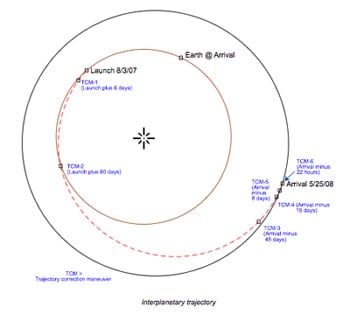

Mars exploration rovers in danger due to Martian storm
quote:July 20, 2007
Dwayne Brown/Tabatha Thompson
Headquarters, Washington
202-358-1726/3895
dwayne.c.brown@nasa.gov, tabatha.thompson-1@nasa.gov
Guy Webster/Gay Yee Hill
Jet Propulsion Laboratory, Pasadena, Calif.
818-354-6278/5011
guy.w.webster@nasa.gov, gay.y.hill@nasa.gov
RELEASE: 07-162
NASA MARS ROVERS BRAVING SEVERE DUST STORMS
PASADENA, Calif. - Having explored Mars for three-and-a-half years in
what were missions originally designed for three months, NASA's Mars
rovers are facing perhaps their biggest challenge.
For nearly a month, a series of severe Martian summer dust storms has
affected the rover Opportunity and, to a lesser extent, its
companion, Spirit. The dust in the Martian atmosphere over
Opportunity has blocked 99 percent of direct sunlight to the rover,
leaving only the limited diffuse sky light to power it. Scientists
fear the storms might continue for several days, if not weeks. "We're
rooting for our rovers to survive these storms, but they were never
designed for conditions this intense," said Alan Stern, associate
administrator of NASA's Science Mission Directorate, Washington.
If the sunlight is further cut back for an extended period, the
rovers
will not be able to generate enough power to keep themselves warm and
operate at all, even in a near-dormant state. The rovers use electric
heaters to keep some of their vital core electronics from becoming
too cold.
Before the dust storms began blocking sunlight last month,
Opportunity's solar panels had been producing about 700 watt hours of
electricity per day, enough to light a 100-watt bulb for seven hours.
When dust in the air reduced the panels' daily output to less than
400 watt hours, the rover team suspended driving and most
observations, including use of the robotic arm, cameras and
spectrometers to study the site where Opportunity is located.
On Tuesday, July 17, the output from Opportunity's solar panels
dropped to 148 watt hours, the lowest point for either rover. On
Wednesday, Opportunity's solar-panel output dropped even lower, to
128 watt hours.
NASA engineers are taking proactive measures to protect the rovers,
especially Opportunity, which is experiencing the brunt of the dust
storm. The rovers are showing robust survival characteristics.
Spirit, in a location where the storm is currently less severe, has
been instructed to conserve battery power by limiting its activities.
"We are taking more aggressive action with both rovers than we needed
before," said John Callas, project manager for the twin rovers at the
Jet Propulsion Laboratory, Pasadena, Calif.
By Opportunity's 1,236th Martian day, which ended Tuesday, driving
and
all science observations had already been suspended. The rover still
used more energy than its solar panels could generate on that day,
drawing down its battery. "The only thing left to cut were some of
the communication sessions," Callas said.
To minimize further the amount of energy Opportunity is using,
mission
controllers sent commands on Wednesday, July 18, instructing the
rover to refrain from communicating with Earth on Thursday and
Friday. This is the first time either of the rovers has been told to
skip communications for a day or more in order to conserve energy.
Engineers calculate that skipping communications sessions should
lower daily energy use to less than 130 watt hours.
A possible outcome of this storm is that one or both rovers could be
damaged permanently or even disabled. Engineers will assess the
capability of each rover after the storm clears.
NASA will provide mission updates as events warrant. The Jet
Propulsion Laboratory manages the rover project for the Science
Mission Directorate.
For more information about the rovers, visit:
http://marsrovers.jpl.nasa.gov
"End this war against drugs. Legalise the drug against wars."
-
[b]Op donderdag 28 september 2006 09:12 schreef Rio het volgende:[/b]
Uiteindelijk is dit een star_gazer-krijgt-een-keiharde-lul-van-zichzelf-omdat-hij-zichzelf-verheven-voelt topic.
-
[b]Op donderdag 28 september 2006 09:12 schreef Rio het volgende:[/b]
Uiteindelijk is dit een star_gazer-krijgt-een-keiharde-lul-van-zichzelf-omdat-hij-zichzelf-verheven-voelt topic.


Wow, het gaat er flink aan toe geloof ik!
"End this war against drugs. Legalise the drug against wars."
-
[b]Op donderdag 28 september 2006 09:12 schreef Rio het volgende:[/b]
Uiteindelijk is dit een star_gazer-krijgt-een-keiharde-lul-van-zichzelf-omdat-hij-zichzelf-verheven-voelt topic.
-
[b]Op donderdag 28 september 2006 09:12 schreef Rio het volgende:[/b]
Uiteindelijk is dit een star_gazer-krijgt-een-keiharde-lul-van-zichzelf-omdat-hij-zichzelf-verheven-voelt topic.
En het verhaal wat erbij hoort
This is a view from Mars Reconnaissance Orbiter of the dust storms around Spirit and Opportunity.
Image credit: NASA/JPL/MSSS
En gezien vanuit Mars Reconnaissance Orbiterquote:For nearly a month, a series of severe Martian summer dust storms has affected the rover Opportunity and, to a lesser extent, its companion, Spirit. The dust in the Martian atmosphere over Opportunity has blocked 99 percent of direct sunlight to the rover, leaving only the limited diffuse sky light to power it. Scientists fear the storms might continue for several days, if not weeks.
"We're rooting for our rovers to survive these storms, but they were never designed for conditions this intense," said Alan Stern, associate administrator of NASA's Science Mission Directorate, Washington.
If the sunlight is further cut back for an extended period, the rovers will not be able to generate enough power to keep themselves warm and operate at all, even in a near-dormant state. The rovers use electric heaters to keep some of their vital core electronics from becoming too cold.
Before the dust storms began blocking sunlight last month, Opportunity's solar panels had been producing about 700 watt hours of electricity per day, enough to light a 100-watt bulb for seven hours. When dust in the air reduced the panels' daily output to less than 400 watt hours, the rover team suspended driving and most observations, including use of the robotic arm, cameras and spectrometers to study the site where Opportunity is located.
On Tuesday, July 17, the output from Opportunity's solar panels dropped to 148 watt hours, the lowest point for either rover. On Wednesday, Opportunity's solar-panel output dropped even lower, to 128 watt hours.
NASA engineers are taking proactive measures to protect the rovers, especially Opportunity, which is experiencing the brunt of the dust storm. The rovers are showing robust survival characteristics. Spirit, in a location where the storm is currently less severe, has been instructed to conserve battery power by limiting its activities.
"We are taking more aggressive action with both rovers than we needed before," said John Callas, project manager for the twin rovers at NASA’s Jet Propulsion Laboratory, Pasadena, Calif.
By Opportunity's 1,236th Martian day, which ended Tuesday, driving and all science observations had already been suspended. The rover still used more energy than its solar panels could generate on that day, drawing down its battery. "The only thing left to cut were some of the communication sessions," Callas said.
To minimize further the amount of energy Opportunity is using, mission controllers sent commands on Wednesday, July 18, instructing the rover to refrain from communicating with Earth on Thursday and Friday. This is the first time either of the rovers has been told to skip communications for a day or more in order to conserve energy. Engineers calculate that skipping communications sessions should lower daily energy use to less than 130 watt hours.
A possible outcome of this storm is that one or both rovers could be damaged permanently or even disabled. Engineers will assess the capability of each rover after the storm clears.
NASA will provide mission updates as events warrant. The Jet Propulsion Laboratory manages the rover project for the Science Mission Directorate.
###
Guy Webster/Gay Yee Hill 818-354-6278/5011
Jet Propulsion Laboratory, Pasadena, California
Dwayne Brown/Tabatha Thompson 202-358-1726/3895
NASA Headquarters, Washington, D.C.
NEWS RELEASE: 2007-080
http://marsrovers.jpl.nas(...)eases/20070720a.html

This is a view from Mars Reconnaissance Orbiter of the dust storms around Spirit and Opportunity.
Image credit: NASA/JPL/MSSS
<a href="http://www.vwkweb.nl/" rel="nofollow" target="_blank">[b]Vereniging voor weerkunde en klimatologie[/b]</a>
<a href="http://www.estofex.org/" rel="nofollow" target="_blank">[b]ESTOFEX[/b]</a>
<a href="http://www.estofex.org/" rel="nofollow" target="_blank">[b]ESTOFEX[/b]</a>
Ik ben echt benieuwd. Die karretjes zijn erg taai gebleken. Ik hoop dat ze dit overleven!
"End this war against drugs. Legalise the drug against wars."
-
[b]Op donderdag 28 september 2006 09:12 schreef Rio het volgende:[/b]
Uiteindelijk is dit een star_gazer-krijgt-een-keiharde-lul-van-zichzelf-omdat-hij-zichzelf-verheven-voelt topic.
-
[b]Op donderdag 28 september 2006 09:12 schreef Rio het volgende:[/b]
Uiteindelijk is dit een star_gazer-krijgt-een-keiharde-lul-van-zichzelf-omdat-hij-zichzelf-verheven-voelt topic.
quote:MARS ROVER UPDATE:
NASA has heard from Mars rover Opportunity, and the report is promising.
On July 23rd, Opportunity's power levels had improved slightly as a result
of several days of energy-conserving silence and low activity.
The rover is struggling to survive a severe dust storm which has darkened the sky,
reducing sunlight to the rover's solar panels by as much as 99 percent:
Meanwhile on the other side of Mars, weekend communications from Spirit indicated
that the sky had cleared slightly, improving power levels for Spirit as well.
"The outlook for both Opportunity and Spirit depends on the weather, which makes it unpredictable,"
says JPL's John Callas, project manager for both rovers.
"If the weather holds where it is now or gets better, the rovers will be OK. If it gets worse,
the situation becomes more complex."
<a href="http://www.vwkweb.nl/" rel="nofollow" target="_blank">[b]Vereniging voor weerkunde en klimatologie[/b]</a>
<a href="http://www.estofex.org/" rel="nofollow" target="_blank">[b]ESTOFEX[/b]</a>
<a href="http://www.estofex.org/" rel="nofollow" target="_blank">[b]ESTOFEX[/b]</a>
quote:DUST STORM UPDATE:
A global dust storm on Mars which began in late June refuses to die down. Clouds of dust are now visible in backyard telescopes and the planet is beginning to resemble a orange billiard ball as all of its underlying surface markings are hidden from view. NASA has commanded Mars rovers Spirit and Opportunity to remain in a state of low activity while solar power is in critically short supply. "We are still waiting out the storms, and we don't know how long they will last or how bad they will get," says John Callas of NASA's Jet Propulsion Laboratory
<a href="http://www.vwkweb.nl/" rel="nofollow" target="_blank">[b]Vereniging voor weerkunde en klimatologie[/b]</a>
<a href="http://www.estofex.org/" rel="nofollow" target="_blank">[b]ESTOFEX[/b]</a>
<a href="http://www.estofex.org/" rel="nofollow" target="_blank">[b]ESTOFEX[/b]</a>
Mars mission....Phoenix is vandaag gelanceerd.
Mei volgend jaar zal Phoenix op Mars landen.
Het is GEEN sonde dat rond zal gaan rijden zoals de rovers die
nu op mars zijn.
Mei volgend jaar zal Phoenix op Mars landen.
Het is GEEN sonde dat rond zal gaan rijden zoals de rovers die
nu op mars zijn.
<a href="http://www.vwkweb.nl/" rel="nofollow" target="_blank">[b]Vereniging voor weerkunde en klimatologie[/b]</a>
<a href="http://www.estofex.org/" rel="nofollow" target="_blank">[b]ESTOFEX[/b]</a>
<a href="http://www.estofex.org/" rel="nofollow" target="_blank">[b]ESTOFEX[/b]</a>
Bron: planetwebquote:Phoenix is een relatief goedkope 'scout' missie uit NASA's Mars Exploration Program. Het is de bedoeling dat Phoenix in het voorjaar van 2008 op de Noordelijke poolkap van Mars landt. Dit is makkelijker gezegd dan gedaan; het mislukken van de Mars Polar Lander (1999) zal bij velen van NASA nog vers in het geheugen zitten.
Voor Phoenix is een ultralicht landingssysteem ontworpen. Het landen zal bestaan uit drie fasen. In de eerste fase zal het hitteschild het voertuig afremmen. Dit wordt gevolgd door een supersonische parachute, die het voortuig afremt tot ongeveer 210 km/uur. Ten slotte zullen pulserende raketjes het voertuig afremmen tot ongeveer 9 km/uur, waarna het voertuig voet op Martiaanse bodem zet.
Phoenix was oorspronkelijk een onderdeel van het Mars Surveyor project. Dit project bestond oorspornkelijk uit een lander en een orbiter, maar de lander werd geschrapt vanwege het falen van de Mars Polar Lander. De orbiter vond wel doorgang en draait momenteel als Mars Odyssey zijn rondjes om de rode planeet. Phoenix kwam eigenlijk in NASA's opslag terecht, en zou zodra er weer budget voor was eventueel weer in actie kunnen komen. Dat is dus nu: Phoenix wordt onder leiding van de universiteit van Arizona ontwikkeld, met financiële en technische steun van NASA. De naam Phoenix is niet toevallig gekozen: in de mythologie is de phoenix een vogel die in het vuur uit zijn as herrijst. Zo ook met de lander, die weer nieuw leven ingeblazen krijgt. Mede hierdoor is het prijskaarte relatief laag: Phoenix kost inclusief lancering "slechts" 386 miljoen dollar.
Phoenix zal een robot-arm bevatten die grondmonsters zal opscheppen. Verwacht wordt dat zowel grond als waterijs opgeschept kan worden met de arm. De arm zal de monsters afleveren bij een tweetal instrumenten (TEGA en MECA), die gebruikt zullen worden om de samenstelling te analyseren. Met deze instrumenten kunnen onder andere organische stoffen gedetecteerd worden, waarmee mogelijk leven aangetoond kan worden. Verder bevat de lander een stereo-camera (om 3D-bril foto's mee te maken), een weerstation en een speciale camera (MARDI) waarmee foto's gemaakt wordt tijdens het landen.
Het is te hopen dat de landing ditmaal slaagt. Mars is berucht om zijn grote aantal mislukte missies, maar NASA is er vrij zeker van dat het ditmaal lukt. Als alles op rolletjes loopt, zal Phoenix ongeveer vier maanden lang onderzoek doen op Mars.
"End this war against drugs. Legalise the drug against wars."
-
[b]Op donderdag 28 september 2006 09:12 schreef Rio het volgende:[/b]
Uiteindelijk is dit een star_gazer-krijgt-een-keiharde-lul-van-zichzelf-omdat-hij-zichzelf-verheven-voelt topic.
-
[b]Op donderdag 28 september 2006 09:12 schreef Rio het volgende:[/b]
Uiteindelijk is dit een star_gazer-krijgt-een-keiharde-lul-van-zichzelf-omdat-hij-zichzelf-verheven-voelt topic.
Wil iemand ff de lenzen schoonmaken.........quote:GOOD NEWS ON MARS:
After six weeks of hunkering down during raging dust storms that limited solar power, Mars rovers Spirit and Opportunity have resumed driving. The storms, albeit not over, are abating and sunlight is beginning to stream through the clouds. Just one problem: dust is settling on the rover's solar panels, which tends to block the intensifying sunlight. On balance, though, the situation is improving and for now the rovers are back in business: more.
D'r zit een beetje stof op

<a href="http://www.vwkweb.nl/" rel="nofollow" target="_blank">[b]Vereniging voor weerkunde en klimatologie[/b]</a>
<a href="http://www.estofex.org/" rel="nofollow" target="_blank">[b]ESTOFEX[/b]</a>
<a href="http://www.estofex.org/" rel="nofollow" target="_blank">[b]ESTOFEX[/b]</a>
Niet te stoppen, die dingen
"End this war against drugs. Legalise the drug against wars."
-
[b]Op donderdag 28 september 2006 09:12 schreef Rio het volgende:[/b]
Uiteindelijk is dit een star_gazer-krijgt-een-keiharde-lul-van-zichzelf-omdat-hij-zichzelf-verheven-voelt topic.
-
[b]Op donderdag 28 september 2006 09:12 schreef Rio het volgende:[/b]
Uiteindelijk is dit een star_gazer-krijgt-een-keiharde-lul-van-zichzelf-omdat-hij-zichzelf-verheven-voelt topic.
HiRISE Confirms Existence of 'Pit Craters' On Mars
by Staff Writers
Tuscon AZ (SPX) Aug 30, 2007
by Staff Writers
Tuscon AZ (SPX) Aug 30, 2007
quote:
The High Resolution Imaging Experiment (HiRISE) camera operated at The University of Arizona released this new view of the dark pit on Arsia Mons (PSP_004847_1745) today. This view is not the entire HiRISE image, but a close-up of the pit on the Arsia Mons volcano. The new image confirms that the dark pit really is a vertical shaft that cuts through lava flow on the flank of the volcano. Such pits form on similar volcanoes in Hawaii and are called "pit craters." (Credit: NASA/JPL/University of Arizona)
The High Resolution Imaging Experiment (HiRISE) has confirmed that a dark pit seen on Mars in an earlier HiRISE image really is a vertical shaft that cuts through lava flow on the flank of the Arsia Mons volcano. Such pits form on similar volcanoes in Hawaii and are called "pit craters."
The HiRISE camera, orbiting the red planet on NASA's Mars Reconnaissance Orbiter, is the most powerful camera ever to orbit another planet. It is operated at The University of Arizona in Tucson. HiRISE Principal Investigator Alfred McEwen of the UA's Lunar and Planetary Laboratory and his team released the new image of the dark pit on Arsia Mons and several other stunning images today on the HiRISE Web site, http://hirise.lpl.arizona.edu. New HiRISE images are released on the site every Wednesday.
The UA-based HiRISE team also released another 930 images to the Planetary Data System (PDS), the U.S. space agency's mission data archive, today. These images, taken between May and July 2007, include a view of what at first glance looks deceptively like a mesa set in Swiss cheese terrain. But it's a case of "trompe l'oeil," an eye trick -- the feature is a crater.
The "Swiss cheese" terrain is carbon dioxide ice that "sublimates," or thaws from a solid directly into gas, during the summer, which it currently is at this south polar region of Mars. Carbon dioxide sublimating on steep slopes changes the shape of pits and mesas from year to year. The large depression in this image might be an impact crater, McEwen said, although it's hard to be sure because there's no raised rim or ejecta. Impact craters on the ice cap are modified as the ice-rich terrain "relaxes" over time and as they are resurfaced by the annual deposition and sublimation of frost and ice.
Another image shows a very recent "rayed" dark impact crater among older pocks in the lighter, dust-covered surface. An extremely recent impact, perhaps only a few years or decades ago, created the dark spot with radial and concentric patterns in this HiRISE image. The small central crater is only about 18 meters wide (60 feet), but it formed a dark spot 700 meters wide (two-fifths mile) with rays of secondary craters reaching as far as 3.7 kilometers (more than two miles) from the central crater, McEwen said. Secondary craters are rocks ejected from the central crater. "This region of Mars is covered by dust, and the impact event must have removed or disturbed the dust to create the dark markings," McEwen said.
All HiRISE images released to the PDS can be viewed from the HiRISE site. There also is a direct link to the full directory listing at http://hirise-pds.lpl.arizona.edu/PDS.
Today's release adds another 1.8 terabytes to the PDS. The project turned over its first 1,200 HiRISE images to PDS last May. The PDS now holds a total 3.5 terabytes of HiRISE data, one of the largest single datasets returned from a spacecraft and archived in NASA's space mission library.
Internet users can explore the images with the user-friendly "IAS Viewer" software that can be downloaded from the HiRISE Web site. IAS-Viewer technology allows users to quickly explore part of an enormous HiRISE image because the software transmits only as much data as needed to render any selected part of the image on a computer screen. The tool delivers a high-resolution view of the selected part of the image regardless of slow or limited Internet connections.
The HiRISE camera takes images of 3.5-mile wide (6 kilometer) swaths as the orbiter flies at about 7,800 mph between 155 and 196 miles (250 to 316 kilometers) above Mars' surface. HiRISE science imaging began in November 2006 and will continue at least through November 2008.

<a href="http://www.vwkweb.nl/" rel="nofollow" target="_blank">[b]Vereniging voor weerkunde en klimatologie[/b]</a>
<a href="http://www.estofex.org/" rel="nofollow" target="_blank">[b]ESTOFEX[/b]</a>
<a href="http://www.estofex.org/" rel="nofollow" target="_blank">[b]ESTOFEX[/b]</a>
STEADY AS SHE GOES......
quote:Phoenix Mars Lander: Radar And Other Gear Pass Checkouts
by Staff Writers
Pasadena CA (SPX) Sep 06, 2007
Two crucial tools for a successful landing of America's latest mission to Mars, the radar and UHF radio on NASA's Phoenix Mars Lander, have passed in-flight checkouts. The ultra-high-frequency radio won't be turned on again until landing day, May 25, 2008, when it will relay communications from Phoenix to orbiters already in service around Mars.
Since launch on Aug. 4, 2007, and until the day it reaches Mars, Phoenix is communicating directly with Earth via even higher frequency X-band radio, mounted on a part of the spacecraft that will be jettisoned shortly before Phoenix hits the top of the Martian atmosphere.
The radar will monitor the spacecraft's fast-shrinking distance to the ground during the final three minutes before touchdown on Mars, triggering descent-engine firings and other necessary events during the most challenging moments of the mission.
The Phoenix flight operations team tested the radar and UHF radio on Aug. 24. Four days earlier, the team ran the first in-flight checkout of a Phoenix science instrument. This test focused on the Thermal and Evolved-Gas Analyzer, which will check for water, carbon-containing molecules and other chemicals of interest in the icy soil of Mars. The checkout verified the health of an ion pump, which will be used during the transit to Mars to remove most water vapor carried from Earth with the instrument. Four additional science instruments are scheduled for checkouts before the spacecraft's next trajectory correction maneuver, planned for Oct. 16.
As of Sept. 1, Phoenix will have covered 81 million kilometers (50 million miles) of its 679-million kilometer (422-million-mile) flight to Mars. It is traveling at 34 kilometers per second (76,000 mph) in relation to the sun. Meanwhile, careful preparations continue for the white-knuckle minutes before landing and the potential scientific discoveries at the landing site.
"Everything is going as planned. No surprises, but this is one of those times when boring is good," said Barry Goldstein, Phoenix project manager at NASA's Jet Propulsion Laboratory, Pasadena, Calif.
Phoenix will fly to a site farther north than any previous Mars landing. The solar-powered lander will robotically dig to underground ice and will run laboratory tests assessing whether the site could have ever been hospitable to microbial life. The instruments will also look for clues about the history of the water in the ice. They will monitor arctic weather as northern Mars' summer progresses toward fall, until solar energy fades and the mission ends.
The Phoenix mission is led by Peter Smith of the University of Arizona, Tucson, with project management at JPL and development partnership at Lockheed Martin, Denver. International contributions are provided by the Canadian Space Agency; the University of Neuchatel, Switzerland; the universities of Copenhagen and Aarhus, Denmark; the Max Planck Institute, Germany; and the Finnish Meteorological Institute. JPL is a division of the California Institute of Technology in Pasadena.
<a href="http://www.vwkweb.nl/" rel="nofollow" target="_blank">[b]Vereniging voor weerkunde en klimatologie[/b]</a>
<a href="http://www.estofex.org/" rel="nofollow" target="_blank">[b]ESTOFEX[/b]</a>
<a href="http://www.estofex.org/" rel="nofollow" target="_blank">[b]ESTOFEX[/b]</a>
http://www.nos.nl/nosjour(...)0907_marsrovers.htmlquote:Marsrovers worden weer wakker 9-09-07
De Marsrovers werken nog prima. Tot die blijde conclusie is NASA gekomen na voor het eerst in een lange tijd weer gebruik te hebben gemaakt van de wagentjes op de rode planeet.
Twee maanden lang moesten de Marsrovers stil blijven staan, omdat er door zandstormen niet genoeg licht was om via de zonnepanelen hun batterijen op te laden.
NASA vreesde zelfs dat de wagentjes al hun stroom zouden opgebruiken, en het contact dus helemaal zou verliezen.
Verbazingwekkend
Maar dat is niet gebeurd.
“De rovers zijn taai.” zegt een woordvoerder NASA trots, “Ze hebben stofwinden, stroomgebrek en andere uitdagingen doorstaan, en het overleefd. Verbazingwekkend.”
De Spirit en de Opportunity rijden al drie-en-een-half jaar rond Mars, terwijl de missie oorspronkelijk maar drie maanden zou duren.
NASA had uit voorzorg de karretjes tijdens de stormen op een energierantsoen gezet: niet rijden, weinig observeren en minder communicatie.
Sinds de zandstormen in augustus begonnen af te nemen, is de NASA weer voorzichtig begonnen met rijden.
Zo heeft de Opportunity 40 meter afgelegd naar de plek waar begonnen zal worden met een afdaling in de Victoriakrater, een spannende, nauwgezette onderneming, waarvoor absoluut mooi weer voor nodig is.
Voor volgende week staat een oefenrit gepland: met alle zes de wielen op de helling, en dan weer terug.
Kapot?
Het enige waar NASA zich nog zorgen over maakt is een spiegeltje van de Opportunity, bovenaan de mast van de wagen, dat gegevens opvangt voor een spectrometer.
Uit de laatste gegevens die NASA ontving, bleek mogelijk dat de spiegel zo gedraaid staat dat hij niet meer uitkijkt over Mars, maar naar de mast staart.
“Als de spiegel niet meer goed kan bewegen, is de spectrometer van Opportunity onbruikbaar. Het zou voor het eerst zijn dat er iets definitief kapot gaat aan een van beide rovers. We zullen zien.”
Mars Rover to Enter Giant Crater
By Alicia Chang
posted: 11 September 2007 03:04 pm ET
NASA's Mars Exploration Rover Opportunity used its navigation camera during the rover's 1,278th Martian day, or sol, (Aug. 28, 2007) to take the images combined into this view. Credit: ESA/JPL-Caltech
By Alicia Chang
posted: 11 September 2007 03:04 pm ET

NASA's Mars Exploration Rover Opportunity used its navigation camera during the rover's 1,278th Martian day, or sol, (Aug. 28, 2007) to take the images combined into this view. Credit: ESA/JPL-Caltech
quote:LOS ANGELES (AP) -- Two months after surviving a giant dust storm, one of NASA's robotic rovers on Mars began a risky drive Tuesday into a crater blasted open by a meteor eons ago.
Scientists want the rover Opportunity to travel 40 feet down toward a bright band of rocks in the Victoria Crater. They believe the rocks represent the ancient surface of Mars and that studying them could shed clues on the planet's early climate.
On Tuesday morning, engineers sent commands to Opportunity to begin its journey, and the robot signaled a confirmation. It will be several hours before scientists know how well the drive is going, and the trek itself will take several days.
Opportunity's first task will be to "toe dip'' into the crater, a move that involves rolling its six wheels below the rim and immediately back out to gauge its footing.
Over the next few days, engineers will check Opportunity's instruments and command it to scale down the crater.
"We expect to have good driving,'' said John Callas, the rover project manager at NASA's Jet Propulsion Laboratory in Pasadena.
The long-awaited descent into the crater -- measuring a half-mile across and about 200 to 230 feet deep -- had been on hold since July when a series of sun-blotting dust storms raged in the southern hemisphere. At the height of the storm, Opportunity and its twin, Spirit, went into sleep mode to conserve energy. Spirit is exploring another area far from Opportunity.
Opportunity reached the lip of the crater last month and scouted for possible entry points. The route scientists eventually chose calls for a straight drive down at a 15-degree incline toward the exposed layer of bright rocks.
During a July teleconference, NASA managers admitted the latest mission was risky, but decided to proceed anyway because of the science that could be learned.
The aging but hardy rovers have been exploring Mars for 3 1/2 years -- far outlasting their primary, three-month mission.
<a href="http://www.vwkweb.nl/" rel="nofollow" target="_blank">[b]Vereniging voor weerkunde en klimatologie[/b]</a>
<a href="http://www.estofex.org/" rel="nofollow" target="_blank">[b]ESTOFEX[/b]</a>
<a href="http://www.estofex.org/" rel="nofollow" target="_blank">[b]ESTOFEX[/b]</a>
Hope for Water on Mars Dims with Sharp New Images
By Jeanna Bryner Staff Writer
posted: 20 September 2007
06:16 pm ET
Images taken with MRO show many gullies on Mars taht include braided channels, terraces and other features that are similar to water-carved features on Earth. Credit: Science
[ Bericht 1% gewijzigd door -CRASH- op 22-09-2007 18:01:32 ]
By Jeanna Bryner Staff Writer
posted: 20 September 2007
06:16 pm ET

Images taken with MRO show many gullies on Mars taht include braided channels, terraces and other features that are similar to water-carved features on Earth. Credit: Science
quote:New images obtained by a sharp-eyed Martian satellite reveal that some Red Planet features once thought to have been carved by flowing water were in fact created by other processes.
The images were taken during the first 100 days of the Mars Reconnaissance Orbiter (MRO) mission and are detailed in a special section of the Sept. 21 issue of the journal Science.
While the results don't confirm or deny the existence of liquid water on Mars' surface, they are no less fascinating, say the scientists involved. For instance, one team found no evidence that flowing water caused bright deposits on the planet. Instead, the scientists proposed dry landslides caused the deposits.
"All findings are good findings," said one team leader Alfred McEwen, a planetary geologist at the University of Arizona.
Philip Christensen of Arizona State University said the MRO results reiterate that "Mars has been fairly dry for the recent past and we need to be careful and not overestimate how much water may have been present, or may have shaped the surface" in ancient times.
"I have been a 'dry Mars guy' for a long time," Christensen said. "These findings are basically saying you look at very high resolution and you do see some evidence for water, there's no disputing that. But you don't see an overwhelming amount of evidence for water."
Lava explosions
The bus-sized MRO orbiting spacecraft, launched in 2005, is equipped with six instruments, including the High-Resolution Imaging Science Experiment camera, or HiRISE, which provides 10 times the resolution of any past Mars imagers. While the MRO images are in some cases inconclusive on the question of Martian water, they are painting a picture of the Martian surface for scientists in unprecedented detail.
In some cases, the images refute past speculation that some of the features were created by flowing water.
A team led by Windy Jaeger of the U.S. Geological Survey in Arizona analyzed HiRISE images of the Athabasca Valles, a young outflow channel system speculated to have been carved out by past catastrophic floods.
"That entire surface is coated with a thin layer of solidified lava, very hard rock that's almost preserved the channel system," Jaeger said, adding: "Catastrophic water floods probably did carve the channel system, but lava flowed through it more recently."
The findings suggest that rather than flooding, steam explosions left behind trails of cone-shaped features found on the floor of Athabasca Valles.
"When water and lava interact it causes a steam explosion," Jaeger told SPACE.com. "And so the lava-covered ground had ground ice in it. And as that water was heated it exploded in steam explosions through the lava."
Dry landslides
McEwen led another research team, which studied a variety of landforms also thought to be associated with past water on Mars. They examined images of gully deposits that had been detected last year by the Mars Global Surveyor. The gully deposits were not present in 1999 images but appeared by 2004. The before-and-after images raised hopes that modern flows of liquid water created the deposits. However, observations from MRO suggest a dry origin, McEwen said.
Both chemical analyses and images of one of the fresh deposits showed no signs of frost or ice and no evidence for even hydrated minerals, all of which could have given the deposits a "bright" appearance.
"We think dry landsliding could've created the bright deposits," McEwen said.
The slopes above this deposit and five other locations are steep enough for sand or loose, dry dust to flow down the gullies, the scientists say. Material uphill could be the source.
In science, discrediting a theory can be just as important as supporting one. "Some science reporters are acting as if we should be disappointed these new bright deposits weren't deposited by water," McEwen said. "We're excited by any advance in understanding Mars no matter what it is."
No ocean
The researchers also ruled out a hypothesis for an ancient ocean on Mars.
The Vastitas Borealis Formation, which covers low-lying northern plains of Mars, was thought to be the result of fine-grained deposits left by an ancient ocean. The new HiRISE images reveal the area, which appeared as flat and featureless in prior missions, is peppered with large boulders.
The mixed-bag of findings intrigue scientists involved.
While Mars is dry now, there remains a lot of water locked up as ice at the poles and beneath the surface away from the poles.
"Ninety-nine percent of Mars is pretty dry and pretty average and not all that exciting," Christensen said. "But the one percent is extremely interesting. So imagine stumbling across an oasis or hot spring out in the middle of a desert. It's a barren desert but gosh that little oasis sure looks attractive."
As an astrobiologist, Christensen says Mars holds plenty of hideouts for life, "I think there are still plenty of places to look for life on Mars."
[ Bericht 1% gewijzigd door -CRASH- op 22-09-2007 18:01:32 ]
<a href="http://www.vwkweb.nl/" rel="nofollow" target="_blank">[b]Vereniging voor weerkunde en klimatologie[/b]</a>
<a href="http://www.estofex.org/" rel="nofollow" target="_blank">[b]ESTOFEX[/b]</a>
<a href="http://www.estofex.org/" rel="nofollow" target="_blank">[b]ESTOFEX[/b]</a>
Het is maar net goed gegaan! Na het verlies van de Mars Global Surveyor had dit wel een flinke domper geweest!
Mars Odyssey weer op jacht naar grotten
De diepzwarte putten in deze afbeelding zijn mogelijk de toegang tot grotten.
Mars Odyssey weer op jacht naar grotten
quote:NASA's Mars Odyssey opereert weer op volle kracht. Vanwege een softwarefout, die op 14 september optrad, heeft de sonde een aantal dagen in 'veilige modus' geopereerd. Deze modus is speciaal gericht op het levend houden van de ruimtesonde en geeft de technici de tijd om het defect te verhelpen. "Het ruimtevaartuig reageerde precies zoals het had moeten doen," aldus Robert Mase van NASA/JPL.
Intussen hopen wetenschappers de sonde weer in te zetten in de jacht naar meer grotten. De zogenaamde "zeven zusters" zijn donkere gaten die gevonden zijn op de flanken van de grote vulkaan Arsia Mons. Ze zijn tussen de 100 en 250 meter in diameter en zijn mogelijk de toegang tot grottenstelsels op de rode planeet. De zeven gezusters bevinden zich op grote hoogte, wat vanwege de zeer lage luchtdruk en temperatuur de kans op leven klein maakt.
"Ze zijn overdag koeler en 's nachts warmer dan hun omgeving," zei Glen Cushing van de Amerikaanse geologische dienst. "De temperatuur van deze grotten is niet zo stabiel als op Aarde, maar komt wel overeen met het vermoeden dat het flinke gaten zijn." De recente vondsten werden gepubliceerd in de online versie van het wetenschappelijke tijdschrift Geophysical research letters. "Of het nou diepe verticale schachten zijn of openingen naar grote grottenstelsels, dit zijn toegangswegen tot de ondergrond van Mars," aldus Tim Titus van USGS. "Grotten op Mars zouden weleens een veilige haven kunnen zijn voor Martiaans leven en kunnen misschien in de toekomst zelfs door mensen gebruikt worden." Omdat Mars geen ozonlaag heeft, is de dosis UV straling aan het oppervlak dodelijk hoog. Door het bovenliggende gesteente kan UV-straling nauwelijks doordringen tot een grot, wat het een veilige haven maakt.
Nu Mars Odyssey weer functioneert, kan de sonde het radioverkeer van en naar de marsrovers Spirit en Opportunity weer doorsturen. De rovers kunnen hun gegevens rechtstreeks naar Aarde sturen, maar de bandbreedte is dan veel kleiner. Mars Odyssey is in 2001 gelanceerd en is bezig aan zijn tweede missie-uitbreiding.

De diepzwarte putten in deze afbeelding zijn mogelijk de toegang tot grotten.
"End this war against drugs. Legalise the drug against wars."
-
[b]Op donderdag 28 september 2006 09:12 schreef Rio het volgende:[/b]
Uiteindelijk is dit een star_gazer-krijgt-een-keiharde-lul-van-zichzelf-omdat-hij-zichzelf-verheven-voelt topic.
-
[b]Op donderdag 28 september 2006 09:12 schreef Rio het volgende:[/b]
Uiteindelijk is dit een star_gazer-krijgt-een-keiharde-lul-van-zichzelf-omdat-hij-zichzelf-verheven-voelt topic.
Kraters zie je erboven en eronder liggenquote:Op woensdag 26 september 2007 14:00 schreef Frutsel het volgende:
Is het niet gewoon een krater
zou wel tof zijn... diepe grotten
dus het verschil is te zien...
--------------------------------------------------------------------------------------------------
quote:MarsDayly.com
NASA aims to put man on Mars by 2037
NASA aims to put a man on Mars by 2037, the administrator of the US space agency indicated here Monday.
This year marks the half-century of the space age ushered in by the October 1957 launch of the Sputnik-1 by the then Soviet Union, NASA administrator Michael Griffin noted.
In 2057, the centenary of the space era, "we should be celebrating 20 years of man on Mars," Griffin told an international astronautics congress in this southern Indian city where he outlined NASA's future goals.
The international space station being built in orbit and targeted for completion by 2010 would provide a "toehold in space" from where humanity can travel first to the moon and then to Mars, Griffin said.
"We are looking at the moon and Mars to build a civilisation for tomorrow and after that," Griffin added in his remarks at a conference session attended by heads of the world's space agencies.
President George W. Bush in 2004 announced an ambitious plan for the US to return to the moon by 2020 and use it as a stepping stone for manned missions to Mars and beyond.
NASA's Phoenix spacecraft is scheduled to land on the northern plains of Mars next year to determine if the Red Planet could support life.
The agency's Mars rovers Opportunity and Spirit resumed their three-year-old mission this month after surviving giant dust storms that nearly destroyed the twin robots.
The rovers were placed in hibernation mode in July to save power because the dust storms were covering their solar panels, impeding their ability to absorb energy from the sun.
And on September 15, 10 gerbils took off from the Russian-run Baikonur space centre in Kazakhstan for a 12-day voyage to test the possible effects of a human mission to Mars.
Missions to the moon and Mars, amid a renewal of global interest in space exploration, are at the top of the agenda for the 2,000 space scientists, astronauts, satellite manufacturers and launchers who gathered in Hyderabad.
NASA is due to start sending a series of robotic missions to the moon starting next year to prepare for future spaceflights and do research on the effects of extended space travel on human beings.
[ Bericht 34% gewijzigd door -CRASH- op 26-09-2007 15:25:48 ]
<a href="http://www.vwkweb.nl/" rel="nofollow" target="_blank">[b]Vereniging voor weerkunde en klimatologie[/b]</a>
<a href="http://www.estofex.org/" rel="nofollow" target="_blank">[b]ESTOFEX[/b]</a>
<a href="http://www.estofex.org/" rel="nofollow" target="_blank">[b]ESTOFEX[/b]</a>
Gisteren een geweldige lezing gehad van een van de topmannen van de NASA marsmissies. Hoewel het uiteraard ook een propaganda-achtige gehalte had, en het van mij op sommige punten wat technisch inhoudelijker had gemogen was het zeer de moeite waard.
De laatste foto's van Opertunity in Victoria zijn overigens van zondag:
Overigens heeft de directie van NASA nog voor 2 jaar subsidie aan de rovers toebedeeld. Als ze het natuurlijk halen tot de volgende zandstormen en er niet nog meer motoren uitvallen...
De laatste foto's van Opertunity in Victoria zijn overigens van zondag:
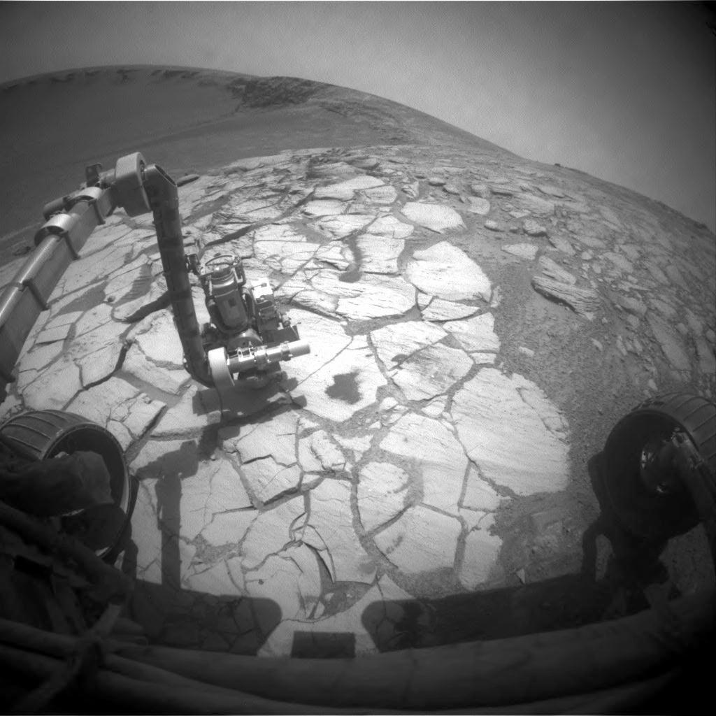
Overigens heeft de directie van NASA nog voor 2 jaar subsidie aan de rovers toebedeeld. Als ze het natuurlijk halen tot de volgende zandstormen en er niet nog meer motoren uitvallen...
Een weetje:
Spirit has driven 7.26 kilometers
and has sent back to Earth more than 102,000 images.
Opportunity has driven 11.57 kilometers
and has returned more than 94,000 images
Spirit has driven 7.26 kilometers
and has sent back to Earth more than 102,000 images.
Opportunity has driven 11.57 kilometers
and has returned more than 94,000 images
<a href="http://www.vwkweb.nl/" rel="nofollow" target="_blank">[b]Vereniging voor weerkunde en klimatologie[/b]</a>
<a href="http://www.estofex.org/" rel="nofollow" target="_blank">[b]ESTOFEX[/b]</a>
<a href="http://www.estofex.org/" rel="nofollow" target="_blank">[b]ESTOFEX[/b]</a>

Die dingen rijden gewoon een paar kilometer per jaar
"End this war against drugs. Legalise the drug against wars."
-
[b]Op donderdag 28 september 2006 09:12 schreef Rio het volgende:[/b]
Uiteindelijk is dit een star_gazer-krijgt-een-keiharde-lul-van-zichzelf-omdat-hij-zichzelf-verheven-voelt topic.
-
[b]Op donderdag 28 september 2006 09:12 schreef Rio het volgende:[/b]
Uiteindelijk is dit een star_gazer-krijgt-een-keiharde-lul-van-zichzelf-omdat-hij-zichzelf-verheven-voelt topic.
Ik vind deze rover missies echt super gaaf. Laat goed zien wat de mensheid kan.
Hopelijk wil de president na Bush wat meer geld in de ruimtevaart stoppen dan Bush er voor over had. (600 miljard aan irak, en NASA heeft het moeilijk )
)
Hopelijk wil de president na Bush wat meer geld in de ruimtevaart stoppen dan Bush er voor over had. (600 miljard aan irak, en NASA heeft het moeilijk
Dit is pas gaafquote:Op dinsdag 23 oktober 2007 11:26 schreef Basekid_NZ het volgende:
Ik vind deze rover missies echt super gaaf. Laat goed zien wat de mensheid kan.
Hopelijk wil de president na Bush wat meer geld in de ruimtevaart stoppen dan Bush er voor over had. (600 miljard aan irak, en NASA heeft het moeilijk
En dit is helemaal top
"End this war against drugs. Legalise the drug against wars."
-
[b]Op donderdag 28 september 2006 09:12 schreef Rio het volgende:[/b]
Uiteindelijk is dit een star_gazer-krijgt-een-keiharde-lul-van-zichzelf-omdat-hij-zichzelf-verheven-voelt topic.
-
[b]Op donderdag 28 september 2006 09:12 schreef Rio het volgende:[/b]
Uiteindelijk is dit een star_gazer-krijgt-een-keiharde-lul-van-zichzelf-omdat-hij-zichzelf-verheven-voelt topic.