WKN Weer, Klimaat en Natuurrampen
Lees alles over het onstuimige weer op onze planeet, volg orkanen en tornado's, zie hoe vulkanen uitbarsten en hoe Moeder Aarde beeft bij een aardbeving. Alles over de verwoestende kracht van onze planeet en tal van andere natuurverschijnselen.


Helaas geen garage in de buurt, maar wel de auto even verplaatst. Aan de overzijde staan grote bomen en een half jaar terug viel daar al een flinke tak vanaf. Dus de auto even midden op een open terrein gezet uit bereik van bomen.quote:Op dinsdag 9 juli 2024 13:34 schreef d.k. het volgende:
Alvast 1 auto in een parkeergarage gezet, die moet mee op vakantie namelijk. Het viel me net nog mee buiten, had het erger verwacht.
25 graden en geen zonquote:Op dinsdag 9 juli 2024 13:52 schreef Jor_Dii het volgende:
[..]
In het ZO nu toch 29 graden of meer op veel plekken. Door die opwarming zal het straks wel flink ontploffen boven België.
Fuck the EBU
Fuck FIA
Pakaak
It's called motorracing.Sorry? We went to carracing Toto
Fuck FIA
Pakaak
It's called motorracing.Sorry? We went to carracing Toto
Gefeliciteerd! Eindelijk weer mooi warm weerquote:
quote:
[..]
Gefeliciteerd! Eindelijk weer mooi warm weerHeerlijk deze temperaturen...zwembad staat. De kinderen zijn helemaal door het dolle heen!
“Rather than love, than money, than fame, give me truth.”

Ik heb het doek van het zwembad afgehaald en nu dobbert vrouwlief erin. Straks de kleine nog even. Ik blijf lekker binnen met dit klote weer.quote:
[..]
Gefeliciteerd! Eindelijk weer mooi warm weer
Water was wel best fris nog, ze heeft de verwarming kort aangezet
100.000 katjes
Fuck the EBU!
Fuck the EBU!
EVERYBODY PANIC @Salinaquote:
[..]
Veel te ver richting het oosten.
Wordt niets dit @:Haags @:Wereldgozer
Goh dat verwacht je toch ook weer niet héquote:
[..]
Veel te ver richting het oosten.
Wordt niets dit @:Haags @:Wereldgozer
Zonder wrijving geen glans
Hoe ziet het er uit voor Rotterdam?quote:
[..]
Veel te ver richting het oosten.
Wordt niets dit @:Haags @:Wereldgozer
Ik hoop dat het verder naar het noorden over Nederland trekt. Begin van de avond familiediner bij mijn broertje.
Zou fijn zijn als we buiten konden zitten.
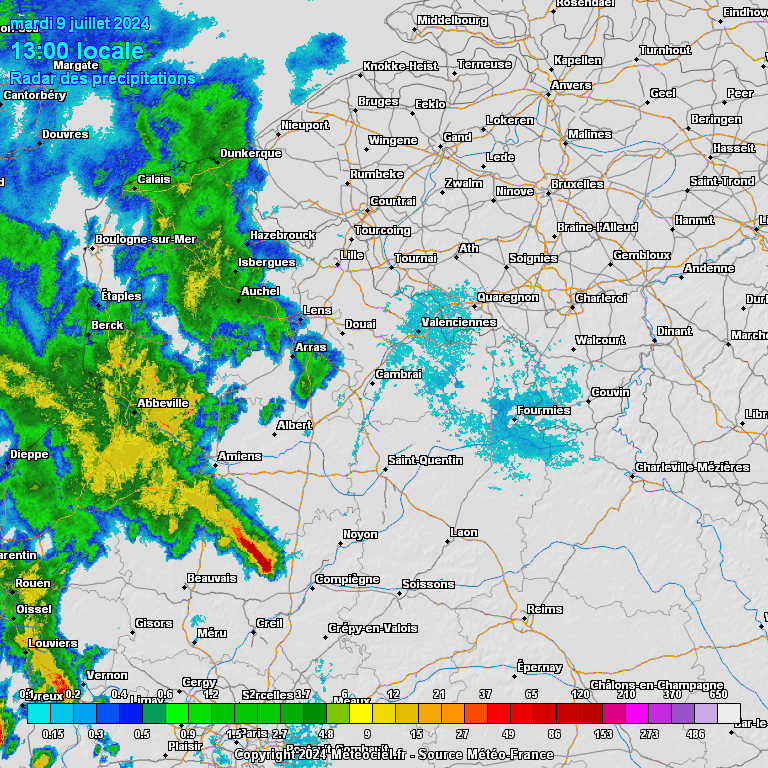
Even voor de duidelijkheid, het gaat hier om Maastricht en directe omgeving.
Zou fijn zijn als we buiten konden zitten.
Even voor de duidelijkheid, het gaat hier om Maastricht en directe omgeving.
Zou tijd worden dat wij wat krijgen... jullie mogen die valwinden, rukwinden en hagelstenenquote:
[..]
Veel te ver richting het oosten.
Wordt niets dit @:Haags @:Wereldgozer
quote:

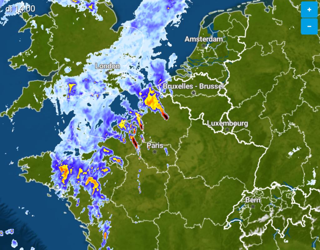
quote:This Mesoscale Discussion was issued for updating reasons. The validity of this MD does not match the anticipated severe risk, which probably starts around 12Z to 13Z and lasts into the overnight hours.
Latest surface data places a weak LL pressure channel from W-CNTRL into NE France with latest data still pointing to a gradually developing and more dominant vortex over NE France, before moving into Belgium/the Netherlands. Latest surface observations already show a vortex next to Paris (10Z). IFS-ENS remains a tad more W with the vortex compared to ICON, but overall NWP guidance remains rather consistent. Ongoing vortex spread still causes a rather broad MD area for now.
Enhanced LL convergence along the evolving low pressure area increases LL moisture depth with dewpoints of mid/upper tens causing MUCAPE in the 800-1300 J/kg range around peak heating. ID2 comes in less agressive but this model has highest warm sector T2m temperatures compared to others with attendant mixing resulting in somewhat lower peak values. Amount of weakly capped CAPE is enough for scattered/intense CI beyond noon. In fact, ongoing convection NE of Paris has a good chance to root into the BL with 25/16C ahead and we might see this growing into a dominant bow.
Most models agree in bringing a 40-50 kt 700 hPa speed maximum into the growing convection from the SW, which assists in 0-3 km shear values along the front of 15-25 m/s and enhancing deep cold pools with forecast temperature gradients of 10K and more. This activity also takes profit of a deeply/well mixed air mass they move into.
ID2-EPS constantly highlights parts of the MD area with probabilities in the 30-40 % range for gusts in excess of 105 km/h and up to 25% for 120 km/h gusts with most models indicating longer-lived bow echo activity within the MD area.
The risk lowers into W-Germany as CIN increases beyond sunset.
Beside the dominant wind risk, isolated large hail and heavy rain will be another issue. A tornado risk is very low-end due to a high LCL environment. With the forecast intense SRH setup, we still can't rule out an isolated event, driven on the mesoscale (e.g. along book-end vortices or due to lowered LCLs by preceeding convection).
Verschroeiende hitte zou idd toepasselijker zijnquote:
Maak dit topic eens vol - deze titel is kut
quote:
[..]
Zou tijd worden dat wij wat krijgen... jullie mogen die valwinden, rukwinden en hagelstenen
100.000 katjes
Fuck the EBU!
Fuck the EBU!

Hmmm. Dat klinkt als een uitdaging.quote:
Maak dit topic eens vol - deze titel is kut