WKN Weer, Klimaat en Natuurrampen
Lees alles over het onstuimige weer op onze planeet, volg orkanen en tornado's, zie hoe vulkanen uitbarsten en hoe Moeder Aarde beeft bij een aardbeving. Alles over de verwoestende kracht van onze planeet en tal van andere natuurverschijnselen.


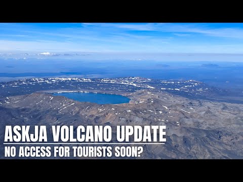
Men verwacht mogelijk ook een uitbarsting van de Askja. De vulkaan stijgt 3 cm per maand en vult zich met magma.
Zou een gigantisch probleem kunnen worden. De autoriteiten willen het gebied nu waarschijnlijk gaan sluiten ivm het risico voor de mensen die de vulkaan bezoeken. Mocht deze uitbarsten en er zijn nog mensen, dan maken die zeer waarschijnlijk geen kans.
Zou een gigantisch probleem kunnen worden. De autoriteiten willen het gebied nu waarschijnlijk gaan sluiten ivm het risico voor de mensen die de vulkaan bezoeken. Mocht deze uitbarsten en er zijn nog mensen, dan maken die zeer waarschijnlijk geen kans.
Er zijn nog wel lichte aardbevingen, tussen de 8 en 15 km diepte. Zwaarste vandaag was 2.0
quote:En dan blijkt dit weekeinde de uitbarsting tot een einde te zijn gekomen, niet officieel, want daar zijn speciale voorwaarden voor/afspraken over, maar voorlopig houden we het op een vredig einde.
Het is echter niet uit te sluiten dat de activiteit verplaatst is en er ergens anders magma ontstaat.
https://www.ijsland-enzo.(...)spagina.asp?tabsel=0


A seismic swarm started north of Grindavík last night
No evidence of magmatic intrusion around Þorbjörn and Grindavík
25.10.2023
Last night an intense earthquake swarm started near Svartsengi, north of Grindavík. Over 1000 earthquakes have been detected there since midnight and the swarm is still ongoing. The largest earthquakes detected are M3.9 at 5:35 UTC and M4.5 at 8:18 UTC. Both of those earthquakes originated at around 5 km depth. Latest deformation data collected from several stations around the Þorbjörn/Grindavík area do not show significant changes correlated with the ongoing seismic activity. In light of the data currently available, this seismicity is interpreted to be likely triggered by the stress changes related to previous intrusive activity on the peninsula. There are currently no indications of magma migration beneath the Þorbjörn/Grindavík area, but the situation might change anytime, and it might evolve over a short time from hours to days. As reported in September a magmatic intrusion is currently ongoing beneath Fagradalsfjall.
Staff of IMO continues to monitor the area closely and interpret newest data as it becomes available.
https://en.vedur.is/about(...)grindavik-last-night

Er zijn duidelijke aanwijzingen dat er op diepte magma beweging is. De grond in dit gebied is aan het stijgen.
Nog geen magma op mindere diepte, maar dat kan een kwestie van tijd zijn. Door alle aardbevingen (7000 inmiddels) bestaat de kans dat de magma wel een snellere weg omhoog vindt.
Nog geen magma op mindere diepte, maar dat kan een kwestie van tijd zijn. Door alle aardbevingen (7000 inmiddels) bestaat de kans dat de magma wel een snellere weg omhoog vindt.
quote:Ground uplift detected northwest of Þorbjörn
New data reveals a complex process of magma movements on the Reykjanes Peninsula
28.10.2023
Updated 28th of October at 1:30pm
The latest cGPS measurements, along with a newly acquired InSAR image over Reykjanes Peninsula, reveals a clear sign of ground uplift, centred around Svartsengi. This uplift signal began at some point on 27 October, and it reflects a pressure increase that is probably caused by a magmatic intrusion at depth. The centre of the uplift signal is around 1.5 km northwest of Þorbjörn, close to the Blue Lagoon. In 2020 and 2022, similar uplift signals were detected in the same area and with similar geometry. This is now the fifth inflation event in the area. From an initial assessment, the ongoing uplift signal is occurring more rapidly than before. Presently, there are no indications of magma moving at shallower depth. However, the situation may evolve rapidly. For instance, significant fracturing has occurred in the Svartsengi area due to triggered seismicity in recent days. Such fracturing could allow magma to find pathways to shallower depth.
Overall, the latest deformation results from the Reykjanes Peninsula show a complex, ongoing process of magma movements in the earth's crust. These processes are affecting a wide area, including Fagradalsfjall (where long-term inflation continues), east of Festarfjall (where the deformation seems to have stopped), and – in the last 24 hours – an area close to Svartsengi shows inflation.
The seismic swarm that began on 25 October north of Grindavík has resulted in over 7.000 earthquakes. The level of earthquake has reduced considerably, although the swarm is still ongoing, meaning that felt earthquakes are still likely.
Geophysical modelling is underway today to determine the depth and size of the uplift source close to Svartsengi. An additional satellite radar image will be available from Reykjanes Peninsula on 29 October. This image should provide an even closer insight into the recent magma movements and deformation pattens on the peninsula.
https://en.vedur.is/about(...)grindavik-last-night
quote:30-10-2023 | 14:00 AARDBEVINGEN REYKJANES
De aardbevingsgolf tussen Blue Lagoon en Grindavík houdt aan, ook één van 4.5 om 12:00
Verontrustend is het, dat de grond ter plekke 3 cm is gerezen in 24 uur. Dit is meer dan bij de vorige 3 uitbarstingen.
Blue Lagoon heeft dagelijks overleg met de betrokken autoriteiten over eventueel te nemen maatregelen.
Uiteraard geldt datzelfde voor Grindavík.
https://www.ijsland-enzo.(...)spagina.asp?tabsel=0
quote:Updated 30th of October at 11:30am
The Sentinel satellite data expected to be received yesterday has not arrived yet, however the cGPS data in the area around Svartensgi and Þorbjörn show that the deformation is still ongoing. The deformation rate since the beginning of this intrusive event has been slightly decreasing over time. Preliminary deformation model results suggest the average depth, where the magmatic instrusion is occurring, is about 4 km.
Over the past 24 hours about 1300 earthquakes have been automatically detected on the Reykjanes Peninsula. Most of this seismicity is located at a depth between 2-4 km. The largest earthquake had a magnitude M2.7 on the 29 October at 11:40UTC.
Scientists from the Icelandic Meteorological Office are undertaking additional surface measurements in the area, including geochemical observations. Regular communication is maintained between IMO, HS-Orka and the Civil Protection while this unrest continues.
quote:The Blue Lagoon (IJslands: Bláa Lónið; "de blauwe lagune") is een geothermisch bad in de buurt van Grindavík, zuidwest IJsland.
Het bad, of eigenlijk een kunstmatig meer, ligt in een oud met mossen begroeid lavaveld. Het water heeft een temperatuur van 39 graden Celsius en bevat ongeveer 2,5% zout. Het warme water is eigenlijk een bijproduct van de geothermische elektriciteitscentrale van Svartsengi. Het water is rijk aan mineralen, silicaten en blauwwieren die het een lichtblauwe, bijna opalescerende kleur geven. Het bad trekt veel mensen met de huidziekte psoriasis omdat het water een helende werking zou hebben. Het bad is een van de grootste toeristische trekpleisters van IJsland.
De lagune registreerde 1,3 miljoen bezoekers in 2017 tegen 919.000 bezoekers in 2015. Het bedrijf had een omzet van € 102 miljoen en een winst van € 31 miljoen in 2017. Het heeft meer dan 600 werknemers.
https://nl.wikipedia.org/wiki/Blue_Lagoon_(zwembad)
Even vertaald uit het Engels. De kans op een uitbarsting is zeer groot, de vraag is meer wanneer.
quote:Bijgewerkt op 2 november om 15.00 uur
GPS-gegevens van de afgelopen 24 uur geven aan dat de stijging zich in een vergelijkbaar tempo voortzet in het gebied ten noordwesten van de berg Þorbjörn. De aardbevingsactiviteit is vrij stabiel geweest, maar gisteren werden ongeveer 800 aardbevingen geregistreerd in het gebied rond Þorbjörn, en de grootste was M3.7 om 12:56 uur. Sinds middernacht vandaag zijn er ongeveer 400 aardbevingen in het gebied geregistreerd, waarvan de grootste om 09.51 uur M2.8 meet. Een meer gedetailleerde analyse van recente GPS-gegevens bevestigt dat zich een magma-indringing vormt op een diepte van 4-5 km onder het gebied ten noordwesten van Þorbjörn.
Het is belangrijk op te merken dat de seismische activiteit waarschijnlijk zal voortduren ten noordwesten van Þorbjörn, en dat aardbevingen boven M4.0 in bevolkte gebieden kunnen voorkomen. Ook kan de komende dagen getriggerde seismische activiteit worden verwacht, omdat het binnendringen van magma voor verhoogde spanningen in het gebied zorgt. Steenslag kan optreden na sterke aardbevingen, dus het is belangrijk om voorzichtig te zijn op steile hellingen.
https://en.vedur.is/about(...)grindavik-last-night


Blijven kijken dus. Live webcam:
https://www.livefromiceland.is/webcams/svartsengi
Wel mooi dat IJsland zo veel goede kwaliteit livestreams heeft.
Terwijl veel weerwebcam-sites over de wereld alleen een foto van het laatste kwartier ofzo laten zien.
https://www.livefromiceland.is/webcams/svartsengi
Wel mooi dat IJsland zo veel goede kwaliteit livestreams heeft.
Terwijl veel weerwebcam-sites over de wereld alleen een foto van het laatste kwartier ofzo laten zien.
Staat als achtergrond aan hier.quote:Op zondag 5 november 2023 17:59 schreef DemonRage het volgende:
Blijven kijken dus. Live webcam:
https://www.livefromiceland.is/webcams/svartsengi
Dat is een elektriciteitscentrale, Svartsengi geothermal power stationquote:
[..]
Wat is dat rechts op de stream dan? Lijkt toch wel magma ofzo?
Dat is de Blue Lagoon. Ze verwachten de uitbarsting zeg maar recht voor de camera, waar die weg loopt.quote:
[..]
Wat is dat rechts op de stream dan? Lijkt toch wel magma ofzo?
En wat is dat gele achterin rechts?quote:Op zondag 5 november 2023 18:37 schreef Houtenbeen het volgende:
[..]
Dat is een elektriciteitscentrale, Svartsengi geothermal power station
Dorpje Grindavik denk ikquote:
[..]
En wat is dat gele achterin rechts?
Nee, Grindavik ligt in het zuiden. Ik heb ff op basis van screenshot en google maps een benadering gemaakt van wat het blikveld van de webcam is:quote:

Dan is het de luchthaven van IJsland/Keflavik of Hafnir, al is dat nog wel een eindjequote:
[..]
Nee, Grindavik ligt in het zuiden. Ik heb ff op basis van screenshot en google maps een benadering gemaakt van wat het blikveld van de webcam is:
[ afbeelding ]
Dat ligt achter de camera idd.quote:
[..]
Nee, Grindavik ligt in het zuiden. Ik heb ff op basis van screenshot en google maps een benadering gemaakt van wat het blikveld van de webcam is:
[ afbeelding ]

https://www.volcanocafe.org/thorbjorn-on-the-brink/
Interessant stuk over de huidige situatie bij Grindavik
Interessant stuk over de huidige situatie bij Grindavik

quote:Rapid crustal uplift at Mt. Þorbjörn, Iceland
The Icelandic Met Office (IMO) has reported a considerable upsurge in seismic activity on the Reykjanes Peninsula, with over 18 500 earthquakes recorded since the swarm began on October 25, just north of Grindavík.
This region, known for its volcanic activity, has experienced a substantial increase in both the frequency and magnitude of seismic events, including five earthquakes exceeding magnitude 4 (M4), with the strongest being a M4.5.
Significant uplift of 7 cm (2.7 inches) has been registered in 10 days at GNSS station on Mt. Þorbjörn
Recent models, based on data collected since October 27, have shown that the volume change associated with this inflation event is nearly double that of the cumulative changes observed during the four previous inflation events between 2020 and 2022.
The IMO’s latest findings indicate a notable uplift of 7 cm (2.7 inches) over a span of just 10 days at the GNSS station situated on Mt. Þorbjörn. In the preceding day alone, approximately 1 300 earthquakes were detected, three of which were above M3, including a M3.6 quake located 3 km (1.8 miles) northeast of Mt. Þorbjörn. This surge in seismic activity correlates with ongoing deformation in the region, pointing to a sustained inflation rate since November 3.
The uplift is caused by a sill-type intrusion at a depth of around 5 km (3.1 miles). Modeling, based on data since October 27, indicates that the volume change associated with this inflation event has reached almost two times the volume change associated with the four previous inflation events in the same area between 2020 – 22.
The inflow of magma/magmatic fluids into the sill-type body is estimated at approximately 7 m3/s — which is about four times greater than the highest inflow estimated during previous inflation events here.
The pattern of seismicity has shifted as well, with decreased activity north of Grindavík since November 2. However, the concentration of earthquakes has been mainly in the Sundhnjúkagígar area, northeast of Þorbjörn, and west of Eldvörp. While the frequency of quakes has reduced, the observed development in earthquake magnitudes and locations is in line with prior episodes linked to magma accumulation near Mt. Þorbjörn.
The ongoing uplift and seismic activity suggest that further stress-induced seismic events are likely to occur. The IMO cautions that rockfalls could follow larger earthquakes, especially near steep inclines, advising the public to exercise caution.
The IMO continues to monitor the situation with vigilance, in collaboration with the Civil Protection Agency, to promptly identify any signs of magma ascent towards the surface, which would manifest as increased, shallow seismicity, rapid surface deformation, and volcanic tremor. While no clear indications of imminent surface magma movement have been detected, the authorities remain alert to the possibility of rapid developments in the region’s volcanic activity.
quote:Reykjanes volcano update: Earthquakes remain at lower intensity, uplift continues, reaches 8 cm
Over the past days, the earthquake swarm has continued at moderate intensity with mainly smaller quakes. The uplift of the area around Thorbjörn mountain continues and has now reached more than 8 cm vertical change as magma underground continues to accumulate.
From yesterday afternoon's update of the Icelandic Met office:
"There have been around 900 earthquakes in the last 24 hours, most of them in the area between Þorbjörn and Sýlingafell. The largest earthquake was M2.9 and occurred around 7 am this morning. The seismic activity remains at the same depth as before.
According to satellite data processed around 5 pm yesterday and covers the period between November 4-6, confirms that uplift continues around Þorbjörn. The same data shows no signs of magma accumulation in Eldvörp or near Sýlingafell, east of Svartsengi where seismic activity has been measued in recent days.
Magma accumulation continues at a depth of around 5 km in the are NW of Þorbjörn. If October 27th is considered the starting day of the inflation event until today, the rate of uplift has been fairly constant, although an acceleration of the process has been observed between days. It is likely that seismic activity will continue, and be episodic in intensity, while magma accumulation is ongoing."
De seismische activiteit in het vulkanische gebied nabij Reykjavik op IJsland houdt aan. De zorgen nemen toe, omdat de geteisterde regio dichtbij een toeristische trekpleister ligt.
De aardbevingszwerm op het schiereiland Reykjanes houdt nu bijna twee weken aan. Van maandag op dinsdag werden er in 24 uur tijd 900 bevingen geregistreerd in het gebied en van zondag op maandag waren dit er maar liefst 1.300. De sterkste hiervan had een magnitude van een 3,6 en vond ongeveer drie kilometer ten noordoosten van de berg Thorbjörn plaats.
Bij een meetpunt op de berg is de aarde volgens het IJslandse meteorologische bureau Vedurstofa nu ongeveer zeven á acht centimeter gestegen. De ondergrondse instroom van magma is aanzienlijk groter dan bij eerdere, soortgelijke gebeurtenissen.
Naar verluidt zijn er echter tot nu toe geen aanwijzingen dat het magma dichterbij het aardoppervlak komt. Desalniettemin wordt de situatie bij Thorbjörn nauwlettend in de gaten gehouden door middel van een livestream op het radiostation RÚV.
Het schiereiland Reykjanes ligt ten zuidwesten van de hoofdstad Reykjavik. Een reeks aardbevingen heeft de afgelopen drie jaar reeds drie keer vulkaanuitbarstingen aangekondigd. De meest recente eruptie vond plaats in juli en hield een paar weken aan, maar leverde geen groot gevaar voor de bevolkte gebieden op.
Zorgen nemen toe
Deze keer wordt echter met bezorgdheid gekeken naar een geothermische energiecentrale in de regio. Direct ernaast ligt namelijk de Blue Lagoon, een thermisch bad dat vooral populair is onder toeristen.
Lees hier verder
In de afgelopen 24 uur zijn ongeveer 1200 aardbevingen waargenomen, waarvan het merendeel plaatsvond in het gebied tussen Þorbjörn en Sýlingafell. Dit aantal vertoont overeenkomsten met de gegevens van de voorgaande dag. De grootste aardbeving, met een magnitude van 3.4, vond gisteravond om 00:31 uur plaats, net ten zuiden van Þorbjörn. De seismische activiteit blijft zich op dezelfde diepte manifesteren als voorheen, en er is een aanzienlijke kans dat deze activiteit aanhoudt en periodiek in intensiteit fluctueert, parallel aan de voortdurende accumulatie van magma.
Op basis van satelliet- en GNSS-gegevens is er geen verandering in het tempo van bodemstijging vergeleken met eerdere metingen. Dit wordt bevestigd door interferogrammen (InSAR) over de periode van 28 oktober tot 6 november, waaruit blijkt dat de verticale beweging bijna onveranderd blijft. Echter, deze gegevens onthullen ook horizontale verschuivingen als gevolg van breukbewegingen in verband met de seismische activiteit.
Bijgewerkte modellen die gebaseerd zijn op dezelfde gegevens schatten dat magma zich nog steeds ophoopt op een horizontale drempel op een diepte van ongeveer 5 kilometer sinds het begin van de inflatiegebeurtenis.
https://en.vedur.is/about(...)grindavik-last-night


quote:Toenemende zorgen - Aardbevingszwerm IJsland houdt aan
In het zuidwesten van IJsland beeft continu de aarde.In het zuidwesten van IJsland beeft continu de aarde.
De seismische activiteit in het vulkanische gebied nabij Reykjavik op IJsland houdt aan. De zorgen nemen toe, omdat de geteisterde regio dichtbij een toeristische trekpleister ligt.
De aardbevingszwerm op het schiereiland Reykjanes houdt nu bijna twee weken aan. Van maandag op dinsdag werden er in 24 uur tijd 900 bevingen geregistreerd in het gebied en van zondag op maandag waren dit er maar liefst 1.300. De sterkste hiervan had een magnitude van een 3,6 en vond ongeveer drie kilometer ten noordoosten van de berg Thorbjörn plaats.
In de afgelopen weken is de bodem op de berg Thorbjörn met acht centimeter gestegen.In de afgelopen weken is de bodem op de berg Thorbjörn met acht centimeter gestegen. © en.vedur.is
Bij een meetpunt op de berg is de aarde volgens het IJslandse meteorologische bureau Vedurstofa nu ongeveer zeven á acht centimeter gestegen. De ondergrondse instroom van magma is aanzienlijk groter dan bij eerdere, soortgelijke gebeurtenissen.
Naar verluidt zijn er echter tot nu toe geen aanwijzingen dat het magma dichterbij het aardoppervlak komt. Desalniettemin wordt de situatie bij Thorbjörn nauwlettend in de gaten gehouden door middel van een livestream op het radiostation RÚV.
vulkaan aardbeving ijslandDe laatste uitbarsting op 11 juli 2023 op het schiereiland Reykjanes nabij Reykjavik, IJsland. - © dpa.
Het schiereiland Reykjanes ligt ten zuidwesten van de hoofdstad Reykjavik. Een reeks aardbevingen heeft de afgelopen drie jaar reeds drie keer vulkaanuitbarstingen aangekondigd. De meest recente eruptie vond plaats in juli en hield een paar weken aan, maar leverde geen groot gevaar voor de bevolkte gebieden op.
Zorgen nemen toe
Deze keer wordt echter met bezorgdheid gekeken naar een geothermische energiecentrale in de regio. Direct ernaast ligt namelijk de Blue Lagoon, een thermisch bad dat vooral populair is onder toeristen.
The Blue Lagoon is zeer geliefd bij toeristen en staat bekend om de thermische baden. The Blue Lagoon is zeer geliefd bij toeristen en staat bekend om de thermische baden.
Voor de stad Grindavik, een paar kilometer zuidelijker, is als een noodevacuatieplan opgesteld. Een dergelijke ontruiming zal zich echter alleen voordoen als de mensen direct in gevaar zijn
Logisch lijkt me. Ik zou er in ieder geval nu niet heen gaan. Ze weten nog steeds niet hoe en wat...quote:
Ik vraag me af of ze ook afwijkingen zien in de temperatuur van het water daar in de Blue Lagoon.quote:
ja vandaag weerquote:Op zondag 5 november 2023 20:57 schreef aloa het volgende:
Je ziet nu wel noorderlicht
[ afbeelding ]
Salivili hipput tupput tapput äppyt tipput hilijalleen
Vandaag, om 12:44 uur, vond een aardbeving met een magnitude van 4.1 plaats in de buurt van Sýlingarfell, ten westen van Sundhnjúkagígar. De kraters bevinden zich ongeveer 2-3 km ten noordoosten van Grindavík. Rond 07:00 uur vanochtend begon een dichte reeks aardbevingen in hetzelfde gebied, en sinds middernacht zijn bijna 800 aardbevingen geregistreerd, waaronder 9 met een magnitude groter dan 3. De diepte van de aardbevingen is ongeveer 5 km. Eerder zijn vergelijkbare aardbevingszwermen in dit gebied waargenomen. Het is niet uit te sluiten dat de seismische activiteit bij Sundhnjúkagígar wordt veroorzaakt door magma-bewegingen op diepte.
Magma blijft zich ophopen in de buurt van Þorbjörn op dezelfde diepte en met een vergelijkbaar tempo als voorheen. Dit gaat gepaard met aardbevingen vergelijkbaar met zwermen, zoals gisteren en vanochtend opgemerkt. Terwijl de ophoping van magma doorgaat, kan door spanningsafgifte in het gebied voortdurende seismische activiteit worden verwacht. Aardbevingen tot magnitude M5.5 kunnen voorkomen in dergelijke zwermen, en de seismische activiteit kan verschuiven tussen verschillende gebieden. Op dit moment zijn er geen aanwijzingen dat magma zich een weg naar het oppervlak baant.
https://en.vedur.is/about(...)grindavik-last-night
Hier goed de aardbeving te zien op de webcam...
[ Bericht 2% gewijzigd door #ANONIEM op 10-11-2023 18:42:27 ]
[ Bericht 2% gewijzigd door #ANONIEM op 10-11-2023 18:42:27 ]
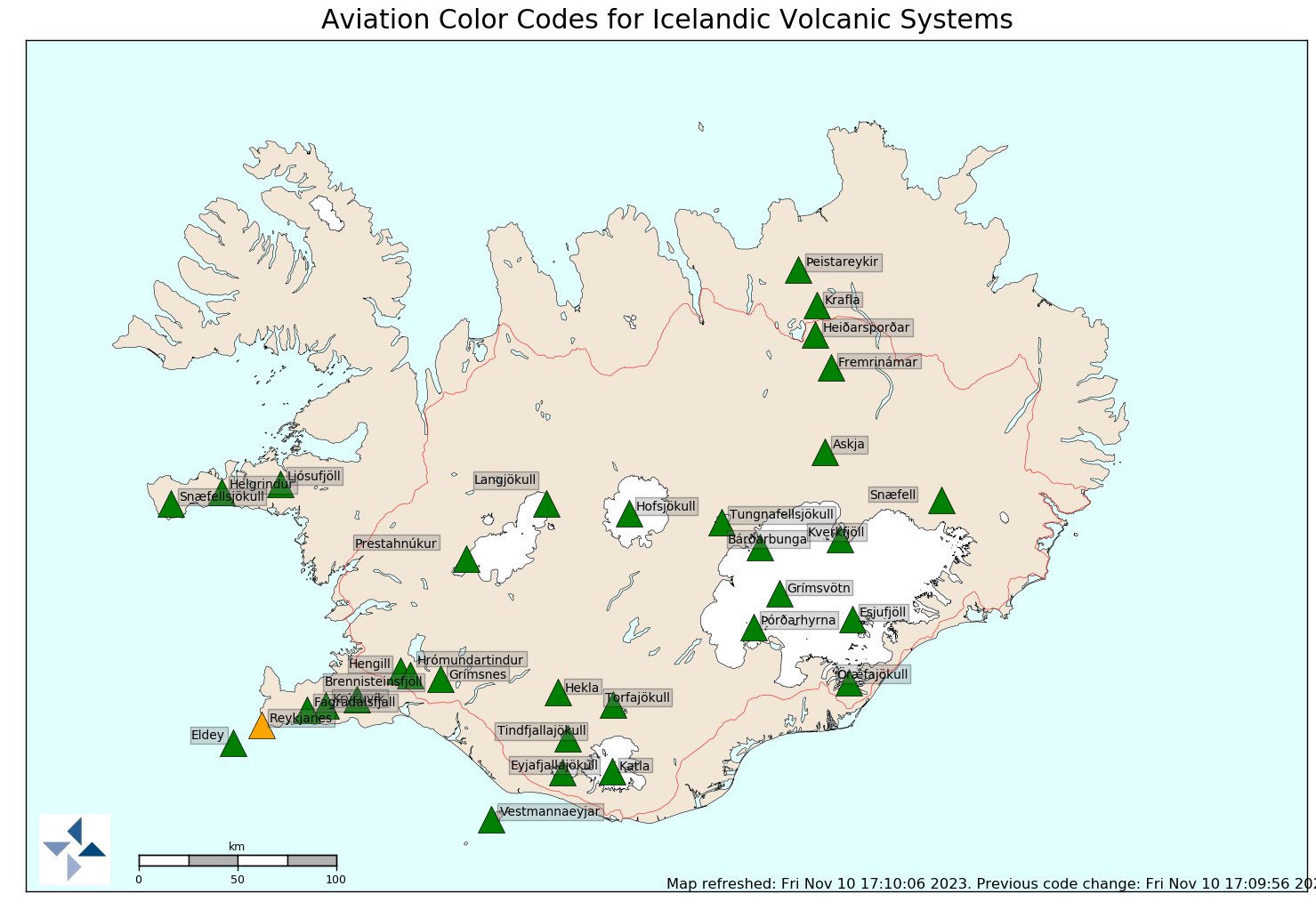
Het lijkt een actieve avond te gaan worden. Voor Keflavik Airport is code geel een half uur geleden opgeschaald naar code oranje (begreep ik van locals op Youtube.)
Salivili hipput tupput tapput äppyt tipput hilijalleen
Die gaat de komende nacht nog wel uitbarsten of morgenquote:
Het lijkt een actieve avond te gaan worden. Voor Keflavik Airport is code geel een half uur geleden opgeschaald naar code oranje (begreep ik van locals op Youtube.)

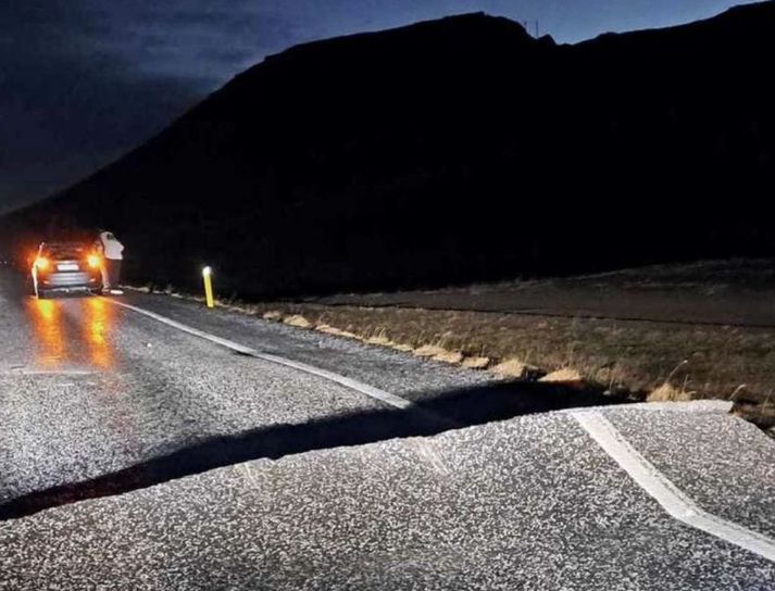
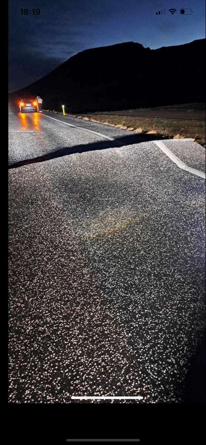
De Grindavikseweg is net afgesloten. De 43. Zit blijkbaar een enorme scheur in.
Salivili hipput tupput tapput äppyt tipput hilijalleen
quote:
De Grindavikseweg is net afgesloten. De 43. Zit blijkbaar een enorme scheur in.

Nee hoorquote:Op vrijdag 10 november 2023 19:30 schreef chufi het volgende:
Als je daar in vast komt te zitten met je wielen dan smelt het rubber waarschijnlijk...

Bevingen worden wel steeds ondieper nu. Net al eentje op 0,2 km 
Salivili hipput tupput tapput äppyt tipput hilijalleen


ja die zag ik ook al ja. Niet erg overzichtelijk meer inmiddelsquote:
Live aardbevingen kaart:
https://vafri.is/quake/
op YT zijn ze ruzie aan het maken welke camera het dichtst bij de action is. Terwijl niemand precies weet waar de action is of gaat komen
[ Bericht 0% gewijzigd door Dr_Flash op 10-11-2023 21:01:12 ]
Salivili hipput tupput tapput äppyt tipput hilijalleen


Merken wij in Nederland hier iets van bij een flinke uitbarsting of is het vooral lokaal een probleem?
vooralsnog merken we niet watquote:Op vrijdag 10 november 2023 22:46 schreef koffiekoekjes het volgende:
Merken wij in Nederland hier iets van bij een flinke uitbarsting of is het vooral lokaal een probleem?
Maar het zal afhangen van de zwaarte van de uitbarsting
Komt er veel as vrij zodat luchtruim dicht moet of is het met name weer een Magma eruptie die langzaam uit een spleet uit de aarde komt en voor weinig overlast zorgt.
Zolang er geen giftige stoffen vrij komen verwacht ik niet veel problemen voor ons maar zo ver reikt mijn kennis ook niet om dit te voorspellen
Het zal geen explosieve uitbarsting worden zoals vulkanen als Ejafjallajökull en Grimsvötn. De luchtvaart zal er geen last van hebben.
De enigen die er last van gaan krijgen zijn diegenen die in het pad van de lavastromen zitten en als het heel erg tegen zit dan hoort daar de energiecentrale ook bij.
De enigen die er last van gaan krijgen zijn diegenen die in het pad van de lavastromen zitten en als het heel erg tegen zit dan hoort daar de energiecentrale ook bij.

ohw hier moest ik zijn 
"I wear the mask to protect the city… but the city is what made the mask." – Batman

Dorp in IJsland geëvacueerd om dreigende vulkaanuitbarsting
Op IJsland is besloten het plaatsje Grindavik, op zo'n vijftig kilometer ten zuidwesten van hoofdstad Reykjavík, te evacueren vanwege een dreigende vulkaanuitbarsting. Het is voor het eerst in drie jaar dat in IJsland een plaats volledig geëvacueerd moet worden, schrijft nieuwssite RUV.
Voor het dorp met zo'n 4000 inwoners is eveneens de noodtoestand afgekondigd. De autoriteiten benadrukken dat de evacuatie een voorzorgsmaatregel is. Seismologen laten weten dat er een magmatunnel onder het dorp loopt. Daardoor is niet uit te sluiten dat er in Grindavik een lavascheur ontstaat.
Het is overigens nog niet zeker dat de vulkaan op de berg Thorbjörn ook daadwerkelijk zal uitbarsten, maar de kans daarop is de afgelopen uren wel groter geworden. Eerder deze week werd de beroemde Blue Lagoon Spa uit voorzorg al ontruimd.
Aardbevingen
De vulkanische activiteit in het gebied is de afgelopen weken toegenomen. Sinds eind vorige maand zijn er op IJsland zo'n 24.000 aardbevingen waargenomen. Gisteren waren dat er zo'n achthonderd, waaronder een zware met een kracht van 5.2.
Op het schiereiland waar Grindavik ligt - Reykjanes - zijn sinds 2021 drie vulkaanuitbarstingen geweest. Daarvoor sliepen de vulkanen op het schiereiland ruim 800 jaar.
Op IJsland zijn zo'n dertig actieve vulkanen. In april 2010 barstte de vulkaan onder de gletsjer Eyjafjallajökull uit. Zo'n 100.000 vluchten werden toen geschrapt, waardoor 10 miljoen reizigers wereldwijd strandden.
https://nos.nl/artikel/24(...)e-vulkaanuitbarsting
 Op
Op