WKN Weer, Klimaat en Natuurrampen
Lees alles over het onstuimige weer op onze planeet, volg orkanen en tornado's, zie hoe vulkanen uitbarsten en hoe Moeder Aarde beeft bij een aardbeving. Alles over de verwoestende kracht van onze planeet en tal van andere natuurverschijnselen.


quote:Alert Level 1 up on Mayon Volcano
THE Philippine Institute of Volcanology and Seismology (Phivolcs) raised Alert Level 1 over Mayon Volcano after it recorded 10 earthquakes over the past 24 hours.
In a statement on Wednesday, Phivolcs said, however, that despite the “abnormal condition”, there was no imminent “magmatic eruption”.
Nonetheless, Phivolcs advised the public to refrain from entering the 6-kilometer Permanent Danger Zone (PDZ).
“Although this means that presently no magmatic eruption is imminent, it is strongly advised that the public refrain from entering the 6-kilometer radius Permanent Danger Zone (PDZ)”, Phivolcs said as it warned that rockfalls, landslides, and ash puffs may occur.
Mayon Volcano’s last recorded eruption was on September 2014.
quote:Op maandag 13 november 2017 18:35 schreef Resistor het volgende:
Even geen zin om het reguliere vulkanentopic op te zoeken, maar:
Livestream van https://en.wikipedia.org/wiki/Popocat%C3%A9petl in Mexico

Behoorlijk actief nu!quote:
And what rough beast, its hour come round at last,
Slouches towards Bethlehem to be born?
Slouches towards Bethlehem to be born?
Zwaarste uitbarsting sinds 2013 van de Popo...
quote:Popocatepetl: Strongest eruption since 2013
On Thursday, November 23, 2017, Mexico's Popocatepetl volcano experienced its strongest eruption since 2013. Ashfall was reported in nearby communities, mainly to the south and southeast.
The eruption started at 20:13 UTC (14:13 local time), producing a plume of ash to around 1 800 m (5 900 feet) above the crater. That's 7 226 m (23 700 feet) above sea level.
"This is the largest activity since 2013," Carlos Valdes Gonzales, General Director of Mexico's National Center for Disaster Prevention (CENAPRED) said on Twitter.
The eruptive event was registered by the Tlamacas and Altzomoni stations, located 4.5 km (2.8 miles) and 12 km (7.4 miles) from the volcano, respectively.
Valdes reminded residents living near the volcano to cover their water sources, wear protective masks and do not let ash accumulate on light roofs.CENAPRED warns residents and tourists not to go near the volcano, especially near the crater due to hazard caused by ballistic fragments.


quote:Second crater inside Popo discovered
The National Center for Disaster Prevention (Cenapred) shared a video of the overflight they made yesterday at the Popocatépetl volcano, where a second crater was discovered inside the volcano.
The director of Cenapred, Carlos Valdés, announced that the interior crater has a diameter of 370 meters and 110 meters deep.
“There is no dome. It is considered an open system, which facilitates the release of recent ash emissions,” Valdés wrote through his Twitter account.
The discovery revealed that in the coming days it is expected that the volcano will continue to throw new material towards the surface and that, gradually, the internal crater will be filled, at least by a mere partial new lava dome.
Therefore, the Cenapred urges people not to approach the volcano and especially the crater, because of the danger involved in spewing and falling fragments.
In addition, he informed that in case of heavy rains, stay away from the ravines posing danger of landslides and mudflows.
The “Popo” volcanic warning light is located in Amarillo Phase 2 .

quote:Major eruption at Bezymianni volcano
A major eruption started at Bezymianni volcano, Kamchatka, Russia at 03:41 UTC on December 20, 2017. According to Tokyo VAAC, volcanic ash plume is reaching 15.2 km (50 000 feet) above sea level and drifting NE. In terms of ash cloud height, this is the strongest eruption anywhere on the planet this year.
The activity at the volcano started gradually increasing on Monday, December 18. According to video data by RAS, hot avalanches at the southeastern flank of the lava dome were observed for several hours, probably as a result of the extrusive eruption.
This activity, accompanied by strong gas-steam activity continued through early December 20 when strong ash explosions started at 03:41 UTC. Ash plume rose to about 8 km (26 000 feet) a.s.l., forcing authorities to raise the Aviation Color Code from Orange to Red.
At 04:09 UTC, ash plume/cloud was extending 20 km (12 miles) NE of the crater. By 04:20 UTC, it was already 85 km (53 miles) NE of the crater.
"Strong ash explosions up to 15 km (49 000 feet) a.s.l. occur at this time," KVERT said 04:47 UTC. "Ongoing activity could affect international and low-flying aircraft," they warned.
quote:St.Helens had four times as many earthquakes as usual
Mount St. Helens, an active volcano, had four times as many earthquakes than usual last month
Something wacky seems to be happening underneath Mount St. Helens.
Early today (Jan. 3), at least 17 earthquakes hit near the active volcano in Washington state, in rapid succession between 12:30am and 6:28am US Pacific time. The first and strongest registered a magnitude of 3.9 on the Richter scale, according to the Pacific Northwest Seismic Network.
Last month, University of Washington seismologists logged more than 80 quakes, a huge increase over the average 17 per month.
Mount St. Helens, 96 miles (154 km) south of Seattle, Washington and 50 miles (80 km) northeast of Portland, Oregon, is part of the Cascade Mountain Range that runs from northern California to British Columbia, Canada. It isn’t the only active volcano in the region—in fact, there are 12 other major volcanoes and nearly 3,000 other volcanic features in the Cascades—but scientists consider it the most active within the past 10,000 years.
Swarms of quakes around the Mount St. Helens are relatively common and do not always suggest a sign of impending eruption. Still, there have been a few instances in recent memory that have led the uptick in seismic activity to cause alarm.
The volcano’s most recent eruption, which occurred from 2004 to 2008, began with harbingers much like today’s: In the early hours of Sept. 23, 2004, a series of small-magnitude, shallow earthquakes rumbled through its lava dome. Over the next seven days, the frequency and size of the earthquakes increased and culminated in the first of several explosions on Oct. 1 2004. Fortunately, after initial steam and volcanic ash eruptions, the volcano only extruded semi-solid lava, which stayed relatively contained. By February 2008, the volcano quieted back down.
Mount St. Helens is most infamous for a 1980 eruption, which caused a horrifying level of devastation.
On May 18 that year, what had begun as tremors on March 20 culminated in a terrible explosion that blew off the volcano’s top 1,300 feet. The eruption caught the surrounding area unprepared and took the lives of 57, the deadliest volcanic event in US history. According to the US Geological Survey, most of the people who died likely did so from from asphyxiation after inhaling hot ash. Many of the victims’ bodies were also never found.
Presently, there seems to be no immediate danger of an eruption, according to geologist Trevor Nace, but scientists are continuing to monitor the situation. “While we can’t be certain,” Nace wrote in Forbes, “chances are the next time Mount St. Helen erupts, we will be significantly better prepared.”
quote:Dormant Kadovar volcano awakens, first eruption in known history, P.N.G.
More than 500 people living on Kadovar Island, East Sepik Province of Papua New Guinea have been evacuated following the first eruption of Kadovar volcano in known history. This volcano, dormant until yesterday, is part of the Schouten Islands, and lies off the coast of New Guinea, about 25 km (15 miles) N of the mouth of the Sepik River. The latest activity at this volcano was a period of heightened thermal phenomena in 1976. The Aviation Color Code for the volcano was raised to Orange. 50 - 60 percent of the island is already covered in lava.
Kadovar started erupting around 12:00 local time Friday, January 5, 2018 (02:00 UTC), prompting authorities to send out boats to evacuate more than 500 people living on Kadovar Island. The boats were sent from Kopar, the nearest island, some 30-minutes boat ride from Kadovar.
According to Loop PNG, immediately after sending boats to Kadovar, Kopar councilor Tom Kelly said that thick clouds can be seen rising from the island. "The clouds are darker and increasing at an alarming rate," Kelly said.
Places like Kairuru Island, Mt Uru in Yangoru and Woginara in the West coast of Wewak District are under thick clouds and dust, Loop PNG reported 00:53 UTC, January 6. Kairuru is not visible from Wewak and Mushu is covered by dust, it said.
In a Loop PNG article published 08:24 UTC, January 6, Ricky Wobar, Wewak District Administrator, said that the situation at Kadovar Island has worsened.
The statement was made after an overflight confirmed lava coming out of the once dormant volcano.
"At least 50 to 60 percent of the island is covered in lava," he said.
Wobar said they saw no evidence of inhabitants on the island, adding that he hopes all of them have been evacuated. The National Disaster and Emergency Services were called in to respond at the earliest tomorrow.

eerste eruptie ooit....
in known historyquote:
[..]
[ afbeelding ]
eerste eruptie ooit....
[b]Op maandag 6 september 2010 00:28 schreef tong80 het volgende:[/b]
GVD Wat moet jij een trotse vader zijn :)
:P
GVD Wat moet jij een trotse vader zijn :)
:P
quote:Kadovar eruption could turn explosive posing risk of landslides or tsunami's
Following the first known eruption of Papua New Guinea's Kadovar volcano that took place on January 5, 2018, the Rabaul Volcanological Observatory (RVO) believes that the eruption could become explosive, posing a risk of landslides and tsunamis.
RVO said they based their belief on the chemistry of the most recent (pre-historic) cumulodome (high-silica andesite), Loop PNG reported January 7.
Landslides, and consequently tsunamis, are possible due to the steepness of the Kadovar Island, RVO said, adding that the risk is high for those on the island while residents on the mainland face a small risk of tsunamis.
Based on satellite imagery and aerial photographs, the eruption started with a mild vulcanian activity from a vent at the south-east base of the cumulodome, which occupies the summit's southeastward breached vent.
"It appears a fissure may be opening just inside of the western wall of the vent's breach, descending down to at least sea level," RVO said in their report to the Department of Mineral Policy and Geohazards Management (DMPGH).
The first eruption of this volcano in known history took place on January 5, 2018, although an unconfirmed eruption might have taken place in 1700, RVO said.
There was no other activity reported until an outbreak of thermal activity in 1976 and a short period of seismic unrest in 2015, the observatory said, adding that the volcano is very remote and communications are difficult, so minor unrest may have gone unreported.
According to local government sources, all residents of the island (some 700 - 800 people) have been evacuated and there are no reports of injuries.
Air Niugini, the national airline of Papua New Guinea, has canceled its Monday's flight to Wewak due to the dust and volcanic ash fallout over the Wewak township, the company said. The flight has been rescheduled to daylight operations on January 9, conditions permitting.
[ Bericht 0% gewijzigd door Frutsel op 27-11-2018 12:25:43 ]
In navolging van de uitbarsting van de Kadovar
WKN / Bewoners van Blup Blup en Bam geëvacueerd na uitbarsting vulkaan
WKN / Bewoners van Blup Blup en Bam geëvacueerd na uitbarsting vulkaan
quote:Warning level raised on another Japanese volcano a week after fatal eruption
TOKYO (Reuters) - Japan raised the warning level on another volcano on Tuesday, exactly a week after an dramatic eruption at another peak killed one man, injured nearly a dozen others and stranded scores of skiers - including foreign tourists - for several hours.
Japan’s Meteorological Agency lifted the warning on Zao, a cluster of volcanoes in northern Japan whose highest point is 1,841 meters (6,040 ft), to 2 from 1, meaning that people should avoid going near the crater.
“There is a possibility of a small-scale eruption,” the agency said in a statement, noting that a number of small earth movements were detected on Tuesday, along with a slight bulging of the ground in one area.
It also warned of the possibility that volcanic rocks could be thrown as far as 1.2 km in any eruption.
The announcement came a week after a member of Japan’s military was struck and killed when rocks from the sudden eruption of the Kusatsu-Shirane volcano rained down on skiers at a mountain resort in central Japan.
Video footage taken by skiers on the mountain, including some from Taiwan, showed black ash boiling up into the sky as stones plummeted down, some punching holes in the metal roof of a ski gondola. Eleven people were injured and around 100 skiers took refuge in a mountain hut for several hours until rescued.
Zao, like Kusatsu-Shirane, is a popular resort area famed for its “snow monsters,” created by water vapor freezing on trees in winter. Its slopes are packed with skiers in winter and hikers in other seasons.
Japan has 110 active volcanoes and monitors 47 of them around the clock. In September 2014, 63 people were killed on Mount Ontake, the worst volcanic disaster in Japan for nearly 90 years.
quote:Alertlevel Vanuatu volcano raised
The Vanuatu Meteorology and Geohazards Department (VMGD) raised the Volcanic Alert Level of Gaua volcano from Level 1 to Level 2 on January 31, 2018. The decision restricts visitors from approaching the volcanic cone. A long period of dormancy of this volcano ended in 1962 with an eruption on its SE flank. Since then, the volcano erupted 15 times, including its last eruption in 2011.
Observations performed from December 2017 to January 2018 confirm that the activity at Gaua volcano consists of ongoing volcanic steam cloud which may content volcanic gases, VGMD said today. These observations and seismic analysis confirm that the volcano activity has increased to the major unrest state.
Alert Level for Gaua volcano was at Level 1 since December 21, 2010. Based on its slight increased seismic activity and observation of ongoing volcanic gas emission and steam plumes in December 2017 and January 2018, the Volcanic Alert Level (VAL) was raised to Level 2. The current observations are consistent with the Alert Level 2 activity which indicates 'Major Unrest' - the danger is around the crater rim and specific area, there is a considerable possibility of an eruption and also a chance of a flank eruption.
VMGD advises all tourism agencies, local authorities, people of Gaua and the general public not to access Gaua's volcanic cone. In this area, volcanic gases will always be expected and other volcanic risks could occur at any time in such major unrest state. In addition, visitors approaching the volcano may smell volcanic gases.
Gaua Island is actually the exposed upper cone and summit of a stratovolcano that is 3 000 meters (10 000 feet) high and 40 kilometers (25 miles) wide. Most of the volcano is submerged beneath the Pacific Ocean.

oud collega is verhuisd naar Vanuatu. Eerste foto die hij op FB gooide na de verhuizing was een selfie met een rokende vulkaan achter hem. Ik verwacht nu meer van dat soort foto'squote:
[b]Op maandag 6 september 2010 00:28 schreef tong80 het volgende:[/b]
GVD Wat moet jij een trotse vader zijn :)
:P
GVD Wat moet jij een trotse vader zijn :)
:P
quote:Op vrijdag 2 februari 2018 16:09 schreef Againzender het volgende:
[..]
oud collega is verhuisd naar Vanuatu. Eerste foto die hij op FB gooide na de verhuizing was een selfie met een rokende vulkaan achter hem. Ik verwacht nu meer van dat soort foto's
DeLuna vindt me dik ;(
Op zondag 22 juni 2014 12:30 schreef 3rdRock het volgende:
pas als jullie gaan trouwen. nu ben je gewoon die Oom Rubber die met onze mama leuke dingen doet :)
Op zondag 22 juni 2014 12:30 schreef 3rdRock het volgende:
pas als jullie gaan trouwen. nu ben je gewoon die Oom Rubber die met onze mama leuke dingen doet :)
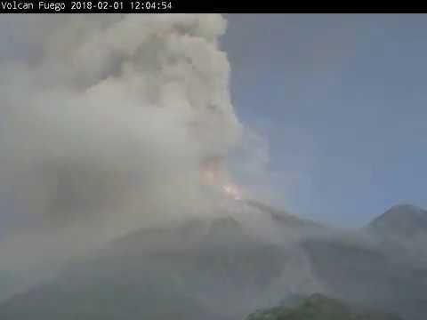
quote:Fuego eruption
Guatemalan authorities issued an Orange Alert for Fuego volcano after its first eruption of the year on February 1, 2018. Explosions at the volcano lasted 20 hours, generating pyroclastic flows and a column of ash up to 6 500 m (21 325 feet) above sea level. Ash drifted up to 40 km (25 miles) to the west and southwest.
CONRED said the eruption affected 47 704 people in the departments of Sacatepéquez, Chimaltenango, Escuintla and Suchitepéquez.
Pyroclastic flows descended through the Honda, Santa Teresa, Las Lajas and Ceniza ravines with lengths between 700 and 1 500 meters (2 300 - 4 900 feet), INSIVUMEH reported.
Ashfall was recorded in the La Rochela and Ceylon communities in Escuintla, Escuintla; in the urban centers of Santa Lucia Cotzumalguapa and Siquinalá, Escuintla; San Pedro Yepocapa, Palo Verde Estate, Sangre de Cristo, Panimaché I and II, Santa Sofía, Morales and Yucales, in Yepocapa, Chimaltenango.
In addition, authorities closed the National Route 14 at kilometer 90 due to the advance of pyroclastic flows. The closure was a preventive measure.
Due to the increase in activity and the presence of ash, the education authorities of Sacatepéquez and Escuintla suspended all educational activities.
To provide a better response and coordination in the municipality, San Juan Alotenango, Sacatepéquez, declared Municipal Red Alert and activated the Municipal Emergency Operations Center, which identifies the places that could function as shelters.
The population living in the vicinity of the volcano is urged to comply with instructions issued by authorities and stay away from the ravines or places that could be affected by ballistic materials expelled from the crater.
In addition, precautionary measures must also be taken for ashfall, protecting the containers where water for human consumption is stored, covering eyes and respiratory passages in the presence of fine ash particles and reporting observed incidents at number 119 of the CONRED.


wowquote:
Mount Sinabung in Indonesië doet boem.
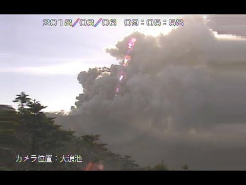
quote:A high impact volcanic ash eruption started at Sinabung volcano, Indonesia at 01:53 UTC on Monday, February 19, 2018. Pyroclastic flows traveled 3.5 km (2.1 miles) and 4.9 km (3 miles) from the summit. Ash plume was reaching an altitude of 16.7 km (55 000 feet) above sea level, the Darwin VAAC reported 04:50 UTC. Aviation Color Code was raised from Orange to Red.
The eruption started at 01:53 UTC (08:53 local time) and lasted 4 minutes and 51 seconds, Sinabung Volcano Observatory reported.
Their best estimate of the ash cloud top at 02:13 UTC was 7.4 km (23 872 feet) above sea level. The observatory noted that the ash cloud is drifting to the east and southeast, adding that its top may be higher than what can be clearly observed from the ground. The Aviation Color Code was raised from Orange to Red.
"Pyroclastic flow is observed through the ESE slope to a distance of 3.5 km [2.1 miles] from the summit and through the south slope to a distance of 4.9 km [3 miles] from the summit," they said.
Major ashfall was reported around the volcano and visibility was down to only 5 to 10 meters (16 - 32 feet).
The volcanic ash cloud is reaching an altitude of 16.7 km (55 000 feet) above sea level and extending 46.3 km (28.7 miles) ENE, the Darwin VAAC reported 03:35 UTC. At the same time, the second volcanic ash cloud was reaching 7.6 km (25 000 feet) a.s.l. and extending 18.5 km (11.5 miles) S.
At 04:53 UTC, the Darwin VAAC said that one volcanic ash cloud was observed reaching an altitude of 13.7 km (45 000 feet) at 04:50 UTC and extending 138.9 km (86.3 miles) to the northwest, while the second volcanic ash cloud was reaching 6.7 km (22 000 feet) and extending 46.3 km (28.7 miles) to the south.
"High impact volcanic eruption is clearly observed on satellite imagery," they noted, adding that the 04:50 UTC volcanic ash cloud heights were estimated based on plume top IR temperature and 00:00 UTC February 19 Medan sounding.


quote:Mount Shinmoe erupted explosive for first time in 7 years
Mount Shinmoe, a volcano in southwestern Japan, has erupted explosively for the first time in 7 years. Japan's Meteorological Agency is warning people not to go near the mountain.
The first eruption took place around 2:30 PM on Tuesday. Smoke spewed up 2,100 meters from the mountain's crater, and air vibrations from the volcanic activity were observed.
Twenty minutes later, after more explosive eruptions, smoke reached a height of 2,300 meters.
The mountain in the Kirishima range straddles Kagoshima and Miyazaki prefectures. Minor eruptions had been occurring at the volcano since Thursday.
Shinmoe last erupted explosively in March 2011.
The agency is keeping its alert level at 3 on a scale up to 5. It's warning of flying volcanic rocks within roughly 3 kilometers of the crater and pyroclastic flows, or fast currents of hot ash and rocks, within 2 kilometers.
It's also telling people downwind to exercise caution against volcanic gas and falling ash and small rocks, and saying windows could be shattered by air vibrations.


Japanse vulkaan voor het eerst in 250 jaar uitgebarsten
De Japanse vulkaan Mount Iō is voor het eerst in 250 jaar uitgebarsten. Donderdag en vrijdag waren grote rookpluimen aan de hemel te zien. De vulkaan spuwde stenen uit die tot twee kilometer ver belandden. Omringende bewoners zijn geëvacueerd.
https://www.nu.nl/234103/(...)ar-uitgebarsten.html
[ Bericht 31% gewijzigd door #ANONIEM op 20-04-2018 10:40:19 ]
De Japanse vulkaan Mount Iō is voor het eerst in 250 jaar uitgebarsten. Donderdag en vrijdag waren grote rookpluimen aan de hemel te zien. De vulkaan spuwde stenen uit die tot twee kilometer ver belandden. Omringende bewoners zijn geëvacueerd.
https://www.nu.nl/234103/(...)ar-uitgebarsten.html

[ Bericht 31% gewijzigd door #ANONIEM op 20-04-2018 10:40:19 ]
NWS / Vulkaan Kilauea op Hawaii barst uit
topic staat tijdelijk in NWS voor als iemand informatie zoekt
topic staat tijdelijk in NWS voor als iemand informatie zoekt
quote:Etna volcano update: Earthquake swarms under eastern and western flanks
The volcano is becoming increasingly restless. Two earthquake swarms have occurred during the past days:
The first was at medium depths (mostly 10-30 km) beneath the eastern flank during 24-26 May, the second one started yesterday and is still continuing under the western flank at depths around 5-10 km. Both could indicate an intrusion of magma, and tremor levels are slightly elevated. Whether this heralds a new eruption in the near future (days, weeks?) is matter of speculation. So far, the quakes have been relatively weak.
When we visited Bocca Nuova last Saturday, we noticed relatively strong, pulsating gas emissions from not-very-deep seated explosions inside the main western vent. According to the mountain guides, this activity had increased, as well as degassing from some areas at the southern rim of the central crater as well as the NE crater
Flinke uitbarstingquote:https://nos.nl/artikel/22(...)sting-guatemala.html
In Guatemala zijn zeker zeven mensen om het leven gekomen bij een vulkaanuitbarsting. Tientallen mensen raakten gewond.
De vulkaan Fuego, zo'n veertig kilometer ten zuidwesten van Guatemala-Stad, spuwt lava en hete as uit. Een lavastroom is het dorpje Rodeo binnengestroomd. "De stroom trad buiten zijn oevers en liep het dorpje in. Er zijn daar gewonde, verbrande en dode mensen", zei het hoofd van de hulpdiensten op de Guatemalteekse radio.
Vier mensen kwamen om het leven toen een huis vlam vatte door de hitte van de lavastroom. Twee kinderen verbrandden toen ze de uitbarsting bekeken vanaf een brug. Een slachtoffer werd gevonden door brandweerlieden en overleed later in de ambulance.


Ja klopt... Fuego topic staat tijdelijk even in NWSquote:
NWS / Guatemala: Veel doden bij vulkaanuitbarsting Fuego

Wie niet of het hier thuishoort aangezien het een geiser is, maar Steamboat in Yellowstone is dit jaar ook weer een paar keer actief geweest, schijnbaar nog niet zo extreem als in 2014., maar al wel een keer of 7 dit jaar....
Kleine geheimen dienen beschermd te worden.
Grote geheimen worden beschermd door publiek ongeloof.
Grote geheimen worden beschermd door publiek ongeloof.