WKN Weer, Klimaat en Natuurrampen
Lees alles over het onstuimige weer op onze planeet, volg orkanen en tornado's, zie hoe vulkanen uitbarsten en hoe Moeder Aarde beeft bij een aardbeving. Alles over de verwoestende kracht van onze planeet en tal van andere natuurverschijnselen.


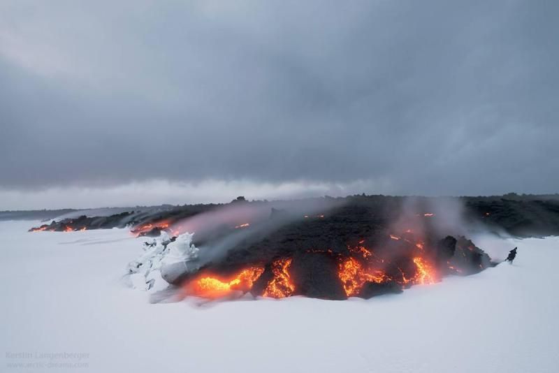
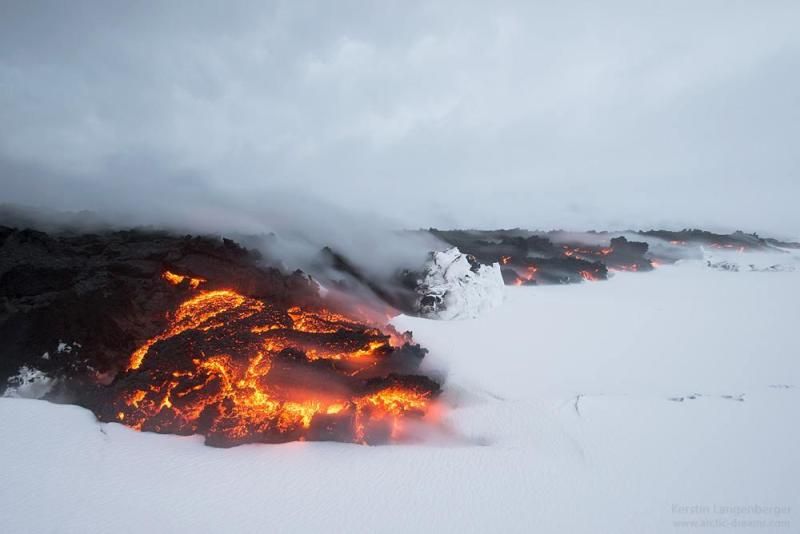
Pretty isn't it? #Holuhraun pahoehoe lava flowing over fresh snow. Credit: Kerstin. Langenberger http://t.co/QAGfjJN7J4
[ Bericht 34% gewijzigd door #ANONIEM op 29-09-2014 13:15:15 ]
[ Bericht 34% gewijzigd door #ANONIEM op 29-09-2014 13:15:15 ]
Bárðarbunguskjálftarnir 16/08-23/09 2014: http://en.vedur.is/earthquakes-and-volcanism/articles/nr/2949
[ Bericht 13% gewijzigd door #ANONIEM op 29-09-2014 13:23:31 ]

[ Bericht 13% gewijzigd door #ANONIEM op 29-09-2014 13:23:31 ]
Wow, in high res wallpaper materiaalquote:Op maandag 29 september 2014 13:13 schreef aloa het volgende:
Pretty isn't it? #Holuhraun pahoehoe lava flowing over fresh snow. Credit: Kerstin. Langenberger http://t.co/QAGfjJN7J4
[ afbeelding ]
*Soms denk ik dat ik over dingen nadenk
http://www.ruv.is/frett/winter-arrives-at-holuhraun
[ Bericht 29% gewijzigd door #ANONIEM op 29-09-2014 14:33:10 ]

<a href="http://goo.gl/q8fhTe" target="_blank">FAQ?</a>
<a href="http://goo.gl/gYvZFq" target="_blank">Geel is een zonnige en vrolijke kleur, als hij tenminste enigszins warm is gekleurd en wat naar het oranje neigt</a>
<a href="http://goo.gl/gYvZFq" target="_blank">Geel is een zonnige en vrolijke kleur, als hij tenminste enigszins warm is gekleurd en wat naar het oranje neigt</a>

Wat een ongelofelijk tof filmpje!quote:Op maandag 29 september 2014 09:18 schreef bwt het volgende:
IMPRESSIVE VIDEOtwitter:lava_ice twitterde op maandag 29-09-2014 om 02:02:18 If you've never seen a river of lava before, this video from #holuhraun is pretty impressive https://t.co/G98KUg2NAB TX @AlisonGraetting reageer retweet
 If you've never seen a river of lava before, this video from
I can only please one person per day. Today is not your day. Tomorrow isn't looking too good either.
De verzakking van de caldera gaat onverminderd door.
Een redelijk strakke lijn
[ Bericht 19% gewijzigd door bwt op 01-10-2014 16:36:47 ]
Een redelijk strakke lijn

[ Bericht 19% gewijzigd door bwt op 01-10-2014 16:36:47 ]
<a href="http://goo.gl/q8fhTe" target="_blank">FAQ?</a>
<a href="http://goo.gl/gYvZFq" target="_blank">Geel is een zonnige en vrolijke kleur, als hij tenminste enigszins warm is gekleurd en wat naar het oranje neigt</a>
<a href="http://goo.gl/gYvZFq" target="_blank">Geel is een zonnige en vrolijke kleur, als hij tenminste enigszins warm is gekleurd en wat naar het oranje neigt</a>
En de bevingen van 1 oktober
[ Bericht 25% gewijzigd door bwt op 01-10-2014 16:44:13 ]

twitter:uni_iceland twitterde op woensdag 01-10-2014 om 16:14:01 New #Holuhraun lava field was ~48.2 km2 yesterday. No signs of any decrease in activity. #Bardarbunga still shaking http://t.co/GMxtEkXfqV reageer retweet
 New
New 
twitter:volcan01010 twitterde op woensdag 01-10-2014 om 15:04:42 #Bardarbunga Science board: http://t.co/qzQjc2LDy2 Eruption and subsidence still going. V high SO2 (5800 micrograms/m3) in Mývatn, 90km N. reageer retweet

[ Bericht 25% gewijzigd door bwt op 01-10-2014 16:44:13 ]
<a href="http://goo.gl/q8fhTe" target="_blank">FAQ?</a>
<a href="http://goo.gl/gYvZFq" target="_blank">Geel is een zonnige en vrolijke kleur, als hij tenminste enigszins warm is gekleurd en wat naar het oranje neigt</a>
<a href="http://goo.gl/gYvZFq" target="_blank">Geel is een zonnige en vrolijke kleur, als hij tenminste enigszins warm is gekleurd en wat naar het oranje neigt</a>

04:30 De SO2-vervuiling is momenteel een grote zorg. Soms worden waarden bereikt van 5800 ug/m3 (10 minuten gemiddelde) in bewoonde gebieden, en dan is er alle reden om binnen te blijven. De harde wind echter zorgt voor veel wisselende waarden, en dat is weer gunstig.
De richting van de gaswolk is zichtbaar in deze animatie (zielink hier onder).
Er blijft veel druk staan op de huidige eruptie, die de aanvoer van magma maar net aankan. Dit betekent dat ook op andere plekken in de magmagang de druk hoog is.
http://www.ijsland-enzo.n(...)spagina.asp?tabsel=3
[ Bericht 1% gewijzigd door #ANONIEM op 02-10-2014 08:57:34 ]
Er zijn nu geen 5+ bevingen meer, maar meer dan genoeg in de 4+ regionen.
Verder lijkt het wel rustiger in de lagere regionen.
[ Bericht 13% gewijzigd door bwt op 02-10-2014 10:47:54 ]
Verder lijkt het wel rustiger in de lagere regionen.


[ Bericht 13% gewijzigd door bwt op 02-10-2014 10:47:54 ]
<a href="http://goo.gl/q8fhTe" target="_blank">FAQ?</a>
<a href="http://goo.gl/gYvZFq" target="_blank">Geel is een zonnige en vrolijke kleur, als hij tenminste enigszins warm is gekleurd en wat naar het oranje neigt</a>
<a href="http://goo.gl/gYvZFq" target="_blank">Geel is een zonnige en vrolijke kleur, als hij tenminste enigszins warm is gekleurd en wat naar het oranje neigt</a>

quote:
DJI Feats: Eruption at Bardabunga Volcano (montag…:

Het blijft stil met de 5+ers.
Daarom maar een mooi plaatje
twitter:IcelandNatural twitterde op donderdag 02-10-2014 om 21:17:03 A double treat for #Iceland visitors - the #Aurora and #Bardarbunga in one! http://t.co/oSALKHIWud http://t.co/yICkvH0hxr reageer retweet
 A double treat for
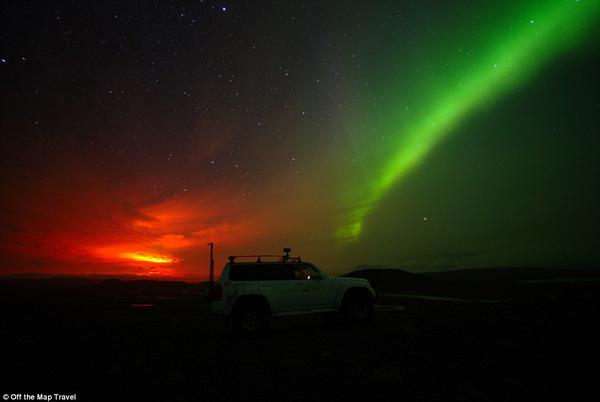
<a href="http://goo.gl/q8fhTe" target="_blank">FAQ?</a>
<a href="http://goo.gl/gYvZFq" target="_blank">Geel is een zonnige en vrolijke kleur, als hij tenminste enigszins warm is gekleurd en wat naar het oranje neigt</a>
<a href="http://goo.gl/gYvZFq" target="_blank">Geel is een zonnige en vrolijke kleur, als hij tenminste enigszins warm is gekleurd en wat naar het oranje neigt</a>
Sterker nog - het waren er 2
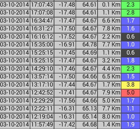
Friday
03.10.2014 12:42:52 64.671 -17.454 7.9 km 5.0 99.0 4.9 km NE of Bárðarbunga
Saturday
04.10.2014 12:05:18 64.677 -17.469 0.9 km 5.0 99.0 4.9 km NE of Bárðarbunga
En een 4.9 en 4.8
Saturday
04.10.2014 18:55:07 64.665 -17.438 2.1 km 4.9 99.0 5.1 km ENE of Bárðarbunga
Sunday
05.10.2014 03:54:54 64.666 -17.450 8.3 km 4.8 99.0 4.7 km NE of Bárðarbunga
<a href="http://goo.gl/q8fhTe" target="_blank">FAQ?</a>
<a href="http://goo.gl/gYvZFq" target="_blank">Geel is een zonnige en vrolijke kleur, als hij tenminste enigszins warm is gekleurd en wat naar het oranje neigt</a>
<a href="http://goo.gl/gYvZFq" target="_blank">Geel is een zonnige en vrolijke kleur, als hij tenminste enigszins warm is gekleurd en wat naar het oranje neigt</a>
23 M3+ earthquakes at #Bardarbunga volcano so far since midnight - a new record in this episode I think?
De verzakking gaat ook lekker door. De 3x 5.0 staan er mooi tussen.
En er zit enige stilte in de bevingen. Of ze zijn nog niet bijgewerkt - dan zien we ze later wel verschijnen - of het is stiller. (Hoewel de kleine bevingen over het algemeen snel bijgewerkt zijn)
[ Bericht 16% gewijzigd door bwt op 06-10-2014 10:46:14 ]

En er zit enige stilte in de bevingen. Of ze zijn nog niet bijgewerkt - dan zien we ze later wel verschijnen - of het is stiller. (Hoewel de kleine bevingen over het algemeen snel bijgewerkt zijn)

[ Bericht 16% gewijzigd door bwt op 06-10-2014 10:46:14 ]
<a href="http://goo.gl/q8fhTe" target="_blank">FAQ?</a>
<a href="http://goo.gl/gYvZFq" target="_blank">Geel is een zonnige en vrolijke kleur, als hij tenminste enigszins warm is gekleurd en wat naar het oranje neigt</a>
<a href="http://goo.gl/gYvZFq" target="_blank">Geel is een zonnige en vrolijke kleur, als hij tenminste enigszins warm is gekleurd en wat naar het oranje neigt</a>
quote:
Daarom maar een mooi plaatje[ afbeelding ]twitter:IcelandNatural twitterde op donderdag 02-10-2014 om 21:17:03 A double treat for #Iceland visitors - the #Aurora and #Bardarbunga in one! http://t.co/oSALKHIWud http://t.co/yICkvH0hxr reageer retweet
En een nieuwe 5.1
Monday
06.10.2014 11:04:04 64.666 -17.447 2.3 km 5.1 99.0 4.8 km NE of Bárðarbunga
[ Bericht 27% gewijzigd door bwt op 06-10-2014 15:32:06 ]

Monday
06.10.2014 11:04:04 64.666 -17.447 2.3 km 5.1 99.0 4.8 km NE of Bárðarbunga

[ Bericht 27% gewijzigd door bwt op 06-10-2014 15:32:06 ]
<a href="http://goo.gl/q8fhTe" target="_blank">FAQ?</a>
<a href="http://goo.gl/gYvZFq" target="_blank">Geel is een zonnige en vrolijke kleur, als hij tenminste enigszins warm is gekleurd en wat naar het oranje neigt</a>
<a href="http://goo.gl/gYvZFq" target="_blank">Geel is een zonnige en vrolijke kleur, als hij tenminste enigszins warm is gekleurd en wat naar het oranje neigt</a>
WTF. Kan mijn post niet aanpassen
[ Bericht 100% gewijzigd door bwt op 07-10-2014 08:53:28 ]
[ Bericht 100% gewijzigd door bwt op 07-10-2014 08:53:28 ]
<a href="http://goo.gl/q8fhTe" target="_blank">FAQ?</a>
<a href="http://goo.gl/gYvZFq" target="_blank">Geel is een zonnige en vrolijke kleur, als hij tenminste enigszins warm is gekleurd en wat naar het oranje neigt</a>
<a href="http://goo.gl/gYvZFq" target="_blank">Geel is een zonnige en vrolijke kleur, als hij tenminste enigszins warm is gekleurd en wat naar het oranje neigt</a>
Mooi overzicht
-------------
Status of Bárðarbunga volcano on 6-October-2014
• The eruption in Holuhraun has picked up again from a minor slowdown on Saturday.
• Strong earthquake activity continues in Bárðarbunga volcano. Strongest earthquake on 6-October-2014 was a magnitude 5,1 earthquake. Other earthquakes have been smaller in magnitude.
• Bad weather is preventing good observation of Bárðarbunga volcano, both in Holuhraun and over Vatnajökull glacier. Visibility can be extremely limited at times.
• SO2 pollution was detected in Reykjavík during the evening of 6-October-2014. It did go over 700 μg/m³ for a short moment in Reykjavík and nearby area. More pollution from the eruption is expected tomorrow.
• The lava field in Holuhraun eruption is now larger than 50 square kilometres in size. I don’t have the exact size for today.
• Bárðarbunga volcano caldera continues to drop and has dropped more than 30 meters by now.
• The activity in Holuhraun appears to be slowly getting smaller with time. This is normal, this also increases the risk of new eruption starting soon.
• No further information for today that I am aware of at this moment.
<a href="http://goo.gl/q8fhTe" target="_blank">FAQ?</a>
<a href="http://goo.gl/gYvZFq" target="_blank">Geel is een zonnige en vrolijke kleur, als hij tenminste enigszins warm is gekleurd en wat naar het oranje neigt</a>
<a href="http://goo.gl/gYvZFq" target="_blank">Geel is een zonnige en vrolijke kleur, als hij tenminste enigszins warm is gekleurd en wat naar het oranje neigt</a>
Een iets grotere vulkaan dan wat het nu is.quote:
Als dit zo door blijft gaan, waar zou het dan toe kunnen leiden?
<a href="http://goo.gl/q8fhTe" target="_blank">FAQ?</a>
<a href="http://goo.gl/gYvZFq" target="_blank">Geel is een zonnige en vrolijke kleur, als hij tenminste enigszins warm is gekleurd en wat naar het oranje neigt</a>
<a href="http://goo.gl/gYvZFq" target="_blank">Geel is een zonnige en vrolijke kleur, als hij tenminste enigszins warm is gekleurd en wat naar het oranje neigt</a>
Das een zwarequote:Magnitude M 5.6
Region ICELAND
Date time 2014-10-07 10:22:34.3 UTC
Location 64.54 N ; 16.95 W
Depth 10 km
Distances 243 km E of Reykjavík, Iceland / pop: 113,906 / local time: 10:22:34.3 2014-10-07
138 km SE of Akureyri / pop: 16,563 / local time: 10:22:00.0 2014-10-07
90 km W of Höfn, Iceland / pop: 1,695 / local time: 10:22:34.3 2014-10-07
Is bijgesteld naar 5.5
Tuesday
07.10.2014 10:22:28 64.604 -17.339 7.5 km 5.5 99.0 9.9 km ESE of Bárðarbunga
Plaatje van de verzakking komt als de 5.5 daarop is verwerkt.
Dit plaatje wordt nog vervangen
[ Bericht 12% gewijzigd door bwt op 08-10-2014 09:54:44 ]
Tuesday
07.10.2014 10:22:28 64.604 -17.339 7.5 km 5.5 99.0 9.9 km ESE of Bárðarbunga


Plaatje van de verzakking komt als de 5.5 daarop is verwerkt.
Dit plaatje wordt nog vervangen

[ Bericht 12% gewijzigd door bwt op 08-10-2014 09:54:44 ]
<a href="http://goo.gl/q8fhTe" target="_blank">FAQ?</a>
<a href="http://goo.gl/gYvZFq" target="_blank">Geel is een zonnige en vrolijke kleur, als hij tenminste enigszins warm is gekleurd en wat naar het oranje neigt</a>
<a href="http://goo.gl/gYvZFq" target="_blank">Geel is een zonnige en vrolijke kleur, als hij tenminste enigszins warm is gekleurd en wat naar het oranje neigt</a>
twitter:volcan01010 twitterde op dinsdag 07-10-2014 om 15:14:00 #Holuhraun area now 52.3km2 in 34 days => ~1.5km2/day => ~one football (soccer) pitch every 7 minutes! #Bardarbunga http://t.co/TunFjsjXic reageer retweet

<a href="http://goo.gl/q8fhTe" target="_blank">FAQ?</a>
<a href="http://goo.gl/gYvZFq" target="_blank">Geel is een zonnige en vrolijke kleur, als hij tenminste enigszins warm is gekleurd en wat naar het oranje neigt</a>
<a href="http://goo.gl/gYvZFq" target="_blank">Geel is een zonnige en vrolijke kleur, als hij tenminste enigszins warm is gekleurd en wat naar het oranje neigt</a>
twitter:eruptionchaser twitterde op woensdag 08-10-2014 om 13:03:33 @eruptionsblog @subglacial I see a distinct trend: it's no straight line; deceleration since day 1: http://t.co/ase170lJmP reageer retweet
 @eruptionsblog @
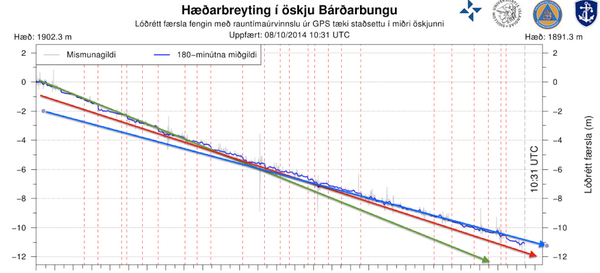
Dat was inderdaad al snel te herkennen
En de discussie hier over op twitter:
twitter:eruptionchaser twitterde op woensdag 08-10-2014 om 13:03:33 @eruptionsblog @subglacial I see a distinct trend: it's no straight line; deceleration since day 1: http://t.co/ase170lJmP reageer retweet
twitter:subglacial twitterde op woensdag 08-10-2014 om 14:46:13 @eruptionchaser @eruptionsblog Hi Mike. Interesting! I see near-linear 23 Sep till now, and slight deceleration from start till 23 Sep. reageer retweet
 @eruptionchaser @
twitter:subglacial twitterde op woensdag 08-10-2014 om 15:17:50 If you are wondering why the #Bárðarbunga caldera collapse appears so regular on the graphs shown at http://t.co/82vnbwtrM5, consider 1/2 reageer retweet
twitter:subglacial twitterde op woensdag 08-10-2014 om 15:20:20 2/2 ...that the GPS station is actually measuring ice movement. And that this is 'buffered' by ductile deformation of a huge mass of ice. reageer retweet
----------twitter:subglacial twitterde op woensdag 08-10-2014 om 15:36:04 A 1 km2 #Bárðarbunga caldera block suddenly dropping 1 m would be registered a few days later as 'background' subsidence by ice-surface GPS. reageer retweet
twitter:alexwitze twitterde op woensdag 08-10-2014 om 14:43:49 Thordarson proposes naming the new #Holuhraun lava field "Nornahraun," the witches' lava http://t.co/u1eNNBow64 HT @subglacial reageer retweet
 Thordarson proposes naming the new
 [ Bericht 29% gewijzigd door bwt op 08-10-2014 15:56:11 ]
<a href="http://goo.gl/q8fhTe" target="_blank">FAQ?</a>
<a href="http://goo.gl/gYvZFq" target="_blank">Geel is een zonnige en vrolijke kleur, als hij tenminste enigszins warm is gekleurd en wat naar het oranje neigt</a>
<a href="http://goo.gl/gYvZFq" target="_blank">Geel is een zonnige en vrolijke kleur, als hij tenminste enigszins warm is gekleurd en wat naar het oranje neigt</a>

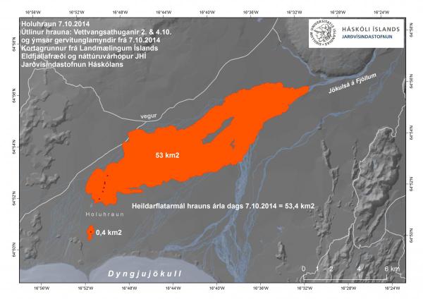
04:00 De belangrijkste krater, genaamd Baugur heeft na 5 weken uitbarsting een hoogte bereikt van 100 meter.
Een andere krater, Suðri is 50 meter hoog. En dan zijn er nog twee kleinere kraters, Helmasatan en Krakklon.
Het lavaveld heeft inmiddels een grootte van meer dan 53 Km2
De lava zorgt er ook voor, dat de Jokulsa zich door een nauwe doorgang moet persen, waarachter zich een meer vormt. Dit loopt echter op regelmatige tijdstippen weer leeg, zodra de Jokulsa een andere weg vindt.
SO2-vervuiling vandaag voornamelijk richting Selfoss en Hella in het zuidwesten.
http://www.ijsland-enzo.n(...)spagina.asp?tabsel=0

http://www.jonfr.com/volcano/
quote:Tourists are continuing to trying to kill them self by getting close to the eruption site. The newest case involves a millionaire (or billionaire?) from Kazakhstan that landed close the lava field. They where lucky that wind did not change direction while they where there. The amount of SO2 close to the eruption has been recorded going up to 130.000 μg/m³. That is good enough to kill instantly and melt people lungs (read up on that can be found here). News item on this stunt can be found here.
Lekkere "toeristen"
De bevingen gaan n iedergeval onverminderd door. Net als de verzakking.
De bevingen gaan n iedergeval onverminderd door. Net als de verzakking.

<a href="http://goo.gl/q8fhTe" target="_blank">FAQ?</a>
<a href="http://goo.gl/gYvZFq" target="_blank">Geel is een zonnige en vrolijke kleur, als hij tenminste enigszins warm is gekleurd en wat naar het oranje neigt</a>
<a href="http://goo.gl/gYvZFq" target="_blank">Geel is een zonnige en vrolijke kleur, als hij tenminste enigszins warm is gekleurd en wat naar het oranje neigt</a>
Hmm, ik zie andere waardes voorbij komen.(graph hier boven) Ik zie een 5.0 van vandaag. (bevingen boven de 3.0)quote:
quote:Thursday
09.10.2014 04:37:16 64.676 -17.467 0.1 km 5.0 99.0 4.9 km NE of Bárðarbunga
Wednesday
08.10.2014 18:48:58 64.671 -17.451 0.1 km 4.6 99.0 5.0 km NE of Bárðarbunga
Wednesday
08.10.2014 18:11:12 64.665 -17.410 2.6 km 3.0 99.0 6.2 km ENE of Bárðarbunga
Wednesday
08.10.2014 15:24:14 64.680 -17.491 5.1 km 5.2 99.0 4.7 km NNE of Bárðarbunga
Wednesday
08.10.2014 15:17:51 64.674 -17.487 3.2 km 3.9 99.0 4.2 km NNE of Bárðarbunga
Wednesday
08.10.2014 04:38:32 64.677 -17.455 5.8 km 3.9 99.0 5.3 km NE of Bárðarbunga
Wednesday
08.10.2014 04:37:47 64.689 -17.434 6.3 km 3.2 99.0 7.0 km NE of Bárðarbunga
<a href="http://goo.gl/q8fhTe" target="_blank">FAQ?</a>
<a href="http://goo.gl/gYvZFq" target="_blank">Geel is een zonnige en vrolijke kleur, als hij tenminste enigszins warm is gekleurd en wat naar het oranje neigt</a>
<a href="http://goo.gl/gYvZFq" target="_blank">Geel is een zonnige en vrolijke kleur, als hij tenminste enigszins warm is gekleurd en wat naar het oranje neigt</a>
En nog een mooie foto van 2 oktober
[ Bericht 33% gewijzigd door bwt op 09-10-2014 13:08:21 ]
twitter:TapasDeCiencia twitterde op donderdag 02-10-2014 om 13:55:54 Bello amanecer en el campo de lava Holuhraun, en las Tierras Altas de Islandia. Foto de Erez Marom. http://t.co/YwEBZTMqHe reageer retweet
 Bello amanecer en el campo de lava Holuhraun, en las Tierras Altas de Islandia. Foto de Erez Marom.
twitter:uni_iceland twitterde op donderdag 09-10-2014 om 12:13:52 Map of new #Holuhraun lava field shows it's ~55 km2 by now. Rough estimate of volume ~0.77 km3 #Bardarbunga http://t.co/C2sZv5aKlK reageer retweet
[ Bericht 33% gewijzigd door bwt op 09-10-2014 13:08:21 ]
<a href="http://goo.gl/q8fhTe" target="_blank">FAQ?</a>
<a href="http://goo.gl/gYvZFq" target="_blank">Geel is een zonnige en vrolijke kleur, als hij tenminste enigszins warm is gekleurd en wat naar het oranje neigt</a>
<a href="http://goo.gl/gYvZFq" target="_blank">Geel is een zonnige en vrolijke kleur, als hij tenminste enigszins warm is gekleurd en wat naar het oranje neigt</a>
Wederom een Mooie Foto
Radar beeld zodat ze ook door de sneeuw en (vulkanische)wolken heen kunnen kijken in de winter.
En het grafische overzicht van de bevingen.
En de verzakking

Radar beeld zodat ze ook door de sneeuw en (vulkanische)wolken heen kunnen kijken in de winter.
En het grafische overzicht van de bevingen.

En de verzakking

<a href="http://goo.gl/q8fhTe" target="_blank">FAQ?</a>
<a href="http://goo.gl/gYvZFq" target="_blank">Geel is een zonnige en vrolijke kleur, als hij tenminste enigszins warm is gekleurd en wat naar het oranje neigt</a>
<a href="http://goo.gl/gYvZFq" target="_blank">Geel is een zonnige en vrolijke kleur, als hij tenminste enigszins warm is gekleurd en wat naar het oranje neigt</a>

Het is weer iets rustiger (voor zo lang het duurt)
<a href="http://goo.gl/q8fhTe" target="_blank">FAQ?</a>
<a href="http://goo.gl/gYvZFq" target="_blank">Geel is een zonnige en vrolijke kleur, als hij tenminste enigszins warm is gekleurd en wat naar het oranje neigt</a>
<a href="http://goo.gl/gYvZFq" target="_blank">Geel is een zonnige en vrolijke kleur, als hij tenminste enigszins warm is gekleurd en wat naar het oranje neigt</a>
Vandaag een aantal zwaardere bevingen van 4+ en één van 5.2.
[ Bericht 6% gewijzigd door #ANONIEM op 12-10-2014 20:27:31 ]
IJsland enzoquote:15:00 Geen nieuwe feiten. Het GPS-apparaat in het midden van de caldera is op dit moment niet functioneel. Met hoopt deze storing snel op te lossen, omdat het de enige manier is om op de hoogte te blijven van de caldera-verzakking.
Een wetenschapper, genaamd Harald Sigurðsson heeft berekend, dat deze uitbarsting in de huidige vorm door kan gaan tot begin maart volgend jaar.
Harald geeft zelf aan, dat gebruik gemaakt is van sterk vereenvoudigde rekenmodellen. De tijd zal leren, in hoeverre Harald gelijk heeft.
[ Bericht 6% gewijzigd door #ANONIEM op 12-10-2014 20:27:31 ]

Verder nog geen officiele melding gezientwitter:jonfr500 twitterde op zondag 12-10-2014 om 03:25:38 I suspect that an eruption has started under the glacier in Bárðarbunga volcano. reageer retweet
 I suspect that an eruption has started under the glacier in Bárðarbunga volcano.
<a href="http://goo.gl/q8fhTe" target="_blank">FAQ?</a>
<a href="http://goo.gl/gYvZFq" target="_blank">Geel is een zonnige en vrolijke kleur, als hij tenminste enigszins warm is gekleurd en wat naar het oranje neigt</a>
<a href="http://goo.gl/gYvZFq" target="_blank">Geel is een zonnige en vrolijke kleur, als hij tenminste enigszins warm is gekleurd en wat naar het oranje neigt</a>

Mooie video opname van afgelopen vrijdag
[ Bericht 13% gewijzigd door bwt op 13-10-2014 14:49:34 ]
Verder nog altijd geen melding waarom de meting van verzakking niet meer werkt...twitter:alexwitze twitterde op zondag 12-10-2014 om 14:17:18 #Holuhraun helicopter video from Friday shows how eruptive fissure is more a lava lake than fire fountains now http://t.co/GKiHUgPBjL reageer retweet
En de lang verwachte update:quote:12 October 2014 10:00 - from geoscientist on duty
The eruption: Webcameras show no significant changes in the eruption.
Earthquakes: Since 10:00 UTC yesterday (Saturday) two quakes over magnitude 5 occurred in Bárðarbunga. The first one M5.0 at 11:30 yesterday and M5.2 at 08:43 this morning. Both originated in the northern rim of the Bárðarbunga caldera. Additionally, four quakes over magnitude 4 were registered: Yesterday M4.7 at 19:33, M4.1 at 01:36 last night, M4.0 at 03:57 and M4.2 at 06:20. Over 100 quakes have been registered during past 24 hours in the caldera and about 25 in the northern part of the intrusion.
Gas pollution: Northeasterly winds are expected today (Sunday), so the pollution is expected towards south and southwest from the eruption. Polluted area is bounded by Faxaflói in the west and Mýrdalur in the east and is expected to extend north of Hofsjökull. Tomorrow (Monday) wind will be southerly and the pollution will go north.
The Icelandic Met Office provides two-day forecasts on gas dispersion from the eruptive site in Holuhraun. Most reliable are the forecast maps approved by meteorologist on duty. And although still being developed further, an automatic forecast (trial run, see disclaimer) is also available.
11 October 2014 10:00 - from geoscientist on duty
From now on a change is made in these reports from a geoscientist on duty, and they will be published daily at about 10:00 UTC. This may be changed if the eruption changes significantly.
The eruption continues with the same lava flow rate as in past weeks.
Seismicity is similar to previous days:
- There is low activity in the dyke intrusion. Around 20 earthquakes have occurred during the last 24 hours, all within magnitude 1.5 and in the northern part of the intrusion between the eruption site and to the south some kilometers under Dyngjujökull glacier.
- About 80 earthquakes were detected on the caldera rim of Bárðarbunga. The largest earthquakes were at 11:26 and 23:51 yesterday, both of magnitude 4.8. Earthquakes of magnitude 4.7 and 4.5 also occurred and seven between 3.0 and 3.9. Most activity was on the northern caldera rim.
Displacements (no significant changes):
- Minor movements of GPS stations in the area.
- Subsidence of the caldera continuing at similar rate.
Water monitoring: No changes.
Gas forecast (latest forecast 09:32 UTC): Today (Saturday) and tomorrow (Sunday): Northeasterly winds are expected with the possibility of gas pollution south and southwest of the eruption site in an area from Hellisheiði in the west to Hornafjörður in the east.
The Icelandic Met Office provides two-day forecasts on gas dispersion from the eruptive site in Holuhraun. Most reliable are the forecast maps approved by meteorologist on duty. And although still being developed further, an automatic forecast (trial run, see disclaimer) is also available.
10 October 2014 19:00 - from geoscientist on duty
Since midnight, no earthquakes above M5 have been detected in the caldera. The largest occurred during the night (4.7 in size) and half an hour before noon, M4.8. Quite a number of smaller quakes has been detected at the caldera (almost 60 since midnight, the majority at the northern rims). Also in the dike (about 20), from the eruptive site and to about 10 km within the Dyngjujökull margin.
An observation from a surveillance flight with TF-SIF today, revealed great blue mist and gas from the eruptive site to about 3 km height above the crater. From there, it is carried across the South Iceland lowland and across West Iceland as far as could be seen from the aircraft. The pollution seems to be greatest just west of Eyjafjallajökull but is also considerable towards Mýrdalssandur.
En het werkt weer.twitter:volcan01010 twitterde op maandag 13-10-2014 om 14:08:41 #Bardarbunga Science board: http://t.co/6lA0NQ2wVw Caldera GPS offline: repair on way. 2 M5.2 EQs at wkend. #Holuhraun STILL same rate. reageer retweet


[ Bericht 13% gewijzigd door bwt op 13-10-2014 14:49:34 ]
<a href="http://goo.gl/q8fhTe" target="_blank">FAQ?</a>
<a href="http://goo.gl/gYvZFq" target="_blank">Geel is een zonnige en vrolijke kleur, als hij tenminste enigszins warm is gekleurd en wat naar het oranje neigt</a>
<a href="http://goo.gl/gYvZFq" target="_blank">Geel is een zonnige en vrolijke kleur, als hij tenminste enigszins warm is gekleurd en wat naar het oranje neigt</a>
En de reden waarom er geen signaal was:
En het bevingen overzicht
twitter:jonfr500 twitterde op dinsdag 14-10-2014 om 01:43:39 @BerryTh No. A relay transmitter ran out of power. So no data could be transmitted from the GPS station on top of Bárðarbunga volcano. reageer retweet

En het bevingen overzicht

<a href="http://goo.gl/q8fhTe" target="_blank">FAQ?</a>
<a href="http://goo.gl/gYvZFq" target="_blank">Geel is een zonnige en vrolijke kleur, als hij tenminste enigszins warm is gekleurd en wat naar het oranje neigt</a>
<a href="http://goo.gl/gYvZFq" target="_blank">Geel is een zonnige en vrolijke kleur, als hij tenminste enigszins warm is gekleurd en wat naar het oranje neigt</a>

twitter:volcan01010 twitterde op dinsdag 14-10-2014 om 16:05:41 Car for scale shows #Holuhraun flow thickness (>8 m). See also sandstorms, fire fountains, lava in river, Me: 2:40. http://t.co/PMVC9XeKKj reageer retweet
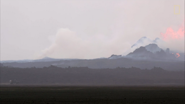
En de video waar bovenstaande plaatje een screenshot van is.
http://news.nationalgeogr(...)rbunga-lava-science/
[ Bericht 8% gewijzigd door bwt op 15-10-2014 09:31:36 ]
<a href="http://goo.gl/q8fhTe" target="_blank">FAQ?</a>
<a href="http://goo.gl/gYvZFq" target="_blank">Geel is een zonnige en vrolijke kleur, als hij tenminste enigszins warm is gekleurd en wat naar het oranje neigt</a>
<a href="http://goo.gl/gYvZFq" target="_blank">Geel is een zonnige en vrolijke kleur, als hij tenminste enigszins warm is gekleurd en wat naar het oranje neigt</a>

Factsheet lijsten door The Civil Protection Scientific Advisory Board
En info van vandaag uit de factsheet PDF
• During last week the eruption continues at a similar intensity and with similar lava flow.
• Around 130 earthquakes have been measured in Bardarbunga over the last 24 hours, which is an increase of what has been the norm over the last two weeks.
• The GPS station in the centre of Bardarbunga is back on-line. The subsidence of the caldera continues with similar rate as before, which is 30-40 cm per day. The subsidence is mainly in the northeast part of the caldera. The subsidence of the caldera is estimated to be 0,75 km3.
• 13 earthquakes greater than M3.0 were recorded over the last 48 hours in or around the caldera. The largest one were M4.8 at 18:51 yesterday.
• Little seismic activity is now detected in the northern part of the dyke and around the eruption site.
• GPS measurements show minor movements. No great changes were detected.
• No change was detected in water monitoring that cannot be explained by changing weather.
twitter:volcan01010 twitterde op woensdag 15-10-2014 om 14:38:10 #Bardarbunga Science board: http://t.co/xVz3Q0IsYM Caldera GPS fixed, subsiding 30-40cm/day, subsided vol: 0.75km3. #Holuhraun still going. reageer retweet

[ Bericht 37% gewijzigd door bwt op 15-10-2014 16:13:55 ]
<a href="http://goo.gl/q8fhTe" target="_blank">FAQ?</a>
<a href="http://goo.gl/gYvZFq" target="_blank">Geel is een zonnige en vrolijke kleur, als hij tenminste enigszins warm is gekleurd en wat naar het oranje neigt</a>
<a href="http://goo.gl/gYvZFq" target="_blank">Geel is een zonnige en vrolijke kleur, als hij tenminste enigszins warm is gekleurd en wat naar het oranje neigt</a>
twitter:Sim0nRedfern twitterde op woensdag 15-10-2014 om 20:58:32 M5.4 #Bardarbunga caldera quake & 20cm collapse: #Holuhraun eruption still strong 2 months after dyke first started http://t.co/TfY80eX4Jj reageer retweet
 M5.4
M5.4 

Al de "zwaardere" bevingen zitten aan de rand van de bardarbunga krater.
Bijna bovenop elkaar.
En er is een "humor" account met de naam Bardarbunga
twitter:Bardarbunga twitterde op donderdag 16-10-2014 om 10:43:21 So? What's up? Been hungover for a couple of days. Too much hot&sweet last weekend. #rimshot #Bardarbunga #ashtag reageer retweet
 So? What's up? Been hungover for a couple of days. Too much hot&sweet last weekend.
 quote:16 October 2014 10:00 - from geoscientist on duty
During the last 24 hours, about 70 earthquakes have been detected at Bárðarbunga and a dozen in the northern part of the dike. This is somewhat less activity than 24 hours earlier. Two quakes over five in magnitude occurred at the northern caldera rim; an M5.4 at 11:16 yesterday and an M5.0 in the early hours of the morning, at 03:14 today. One earthquake M4.2 occurred later this morning, at 09:25, in a similar location.
Observations of deep thudding sounds were received yesterday while the large earthquake occurred, possibly as a consequence thereof. Scientist went to Askja yesterday but found no signs of a rockfall, which could have caused the noises. Possibly the sounds were from jet aircrafts, passing at the same time.
[ Bericht 20% gewijzigd door bwt op 16-10-2014 14:43:23 ]
<a href="http://goo.gl/q8fhTe" target="_blank">FAQ?</a>
<a href="http://goo.gl/gYvZFq" target="_blank">Geel is een zonnige en vrolijke kleur, als hij tenminste enigszins warm is gekleurd en wat naar het oranje neigt</a>
<a href="http://goo.gl/gYvZFq" target="_blank">Geel is een zonnige en vrolijke kleur, als hij tenminste enigszins warm is gekleurd en wat naar het oranje neigt</a>

De laatste piek is waar onderstaande tweet over gaat.
twitter:eruptionchaser twitterde op vrijdag 17-10-2014 om 04:21:42 @eruptionsblog @subglacial Interesting. 16.11 event today only 4.6 but biggest spike on DYN tremor plot since August: http://t.co/NPs5oACuM3 reageer retweet

twitter:jonfr500 twitterde op vrijdag 17-10-2014 om 02:09:35 @eruptionsblog New video of the Holuhraun eruption. Showing lava rivers and such things. http://t.co/cCI0zXbosl reageer retweet
 @eruptionsblog New video of the Holuhraun eruption. Showing lava rivers and such things.
 [ Bericht 13% gewijzigd door bwt op 17-10-2014 10:11:06 ]
<a href="http://goo.gl/q8fhTe" target="_blank">FAQ?</a>
<a href="http://goo.gl/gYvZFq" target="_blank">Geel is een zonnige en vrolijke kleur, als hij tenminste enigszins warm is gekleurd en wat naar het oranje neigt</a>
<a href="http://goo.gl/gYvZFq" target="_blank">Geel is een zonnige en vrolijke kleur, als hij tenminste enigszins warm is gekleurd en wat naar het oranje neigt</a>
En 2 berichten die elkaar lijken tegen te spreken. - de 2e zal wel verkeerd door google translate zijn gekomen.
twitter:gislio twitterde op vrijdag 17-10-2014 om 13:56:24 Restricted closed area around #Holuhraun has been made smaller - a danger area still same. #Bardarbunga http://t.co/7pANl05qze reageer retweet
 Restricted closed area around
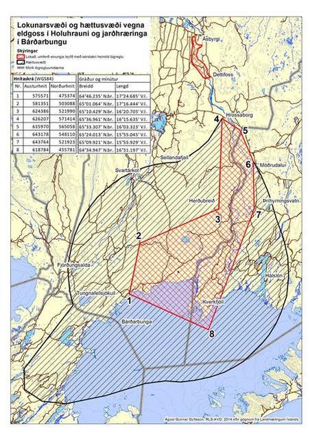
twitter:eruptionchaser twitterde op vrijdag 17-10-2014 om 14:39:53 @eruptionsblog @subglacial Heightened risk at #Bárðarbunga danger area extended: https://t.co/rrAwU923ar reageer retweet
<a href="http://goo.gl/q8fhTe" target="_blank">FAQ?</a>
<a href="http://goo.gl/gYvZFq" target="_blank">Geel is een zonnige en vrolijke kleur, als hij tenminste enigszins warm is gekleurd en wat naar het oranje neigt</a>
<a href="http://goo.gl/gYvZFq" target="_blank">Geel is een zonnige en vrolijke kleur, als hij tenminste enigszins warm is gekleurd en wat naar het oranje neigt</a>
twitter:eruptionchaser twitterde op vrijdag 17-10-2014 om 15:06:31 Whatever is happening at #Bárðarbunga , it's a lot stronger on VON than DYN: http://t.co/IzWLJEoIpW reageer retweet
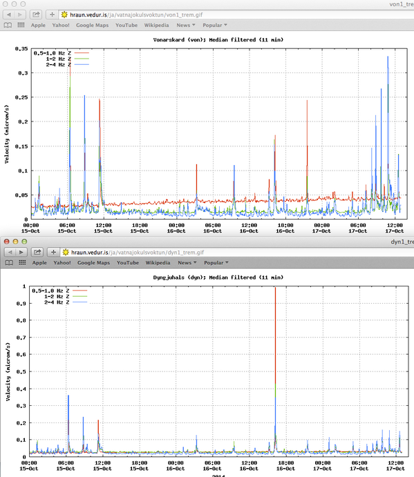

Mooie plaatjes onder de link
twitter:mblfrettir twitterde op vrijdag 17-10-2014 om 15:39:53 Holuhraun is still creating beautiful rivers of lava - http://t.co/svGTf4jKzQ reageer retweet
 Holuhraun is still creating beautiful rivers of lava -
 quote:The eruption in Holuhraun has subsided somewhat. Pollution from poison gases is now the largest problem arising from the eruption. There is still considerable seismic activity in the Bardarbunga crater, with quakes coming at frequent intervals and ending in a large quake.
twitter:jonfr500 twitterde op vrijdag 17-10-2014 om 18:27:27 It is my opinion that there is now a higher risk of eruption in Tungnafellsjökull volcano. http://t.co/iIXBWde1qs reageer retweet
[ Bericht 19% gewijzigd door bwt op 17-10-2014 20:17:22 ]
<a href="http://goo.gl/q8fhTe" target="_blank">FAQ?</a>
<a href="http://goo.gl/gYvZFq" target="_blank">Geel is een zonnige en vrolijke kleur, als hij tenminste enigszins warm is gekleurd en wat naar het oranje neigt</a>
<a href="http://goo.gl/gYvZFq" target="_blank">Geel is een zonnige en vrolijke kleur, als hij tenminste enigszins warm is gekleurd en wat naar het oranje neigt</a>