WKN Weer, Klimaat en Natuurrampen
Lees alles over het onstuimige weer op onze planeet, volg orkanen en tornado's, zie hoe vulkanen uitbarsten en hoe Moeder Aarde beeft bij een aardbeving. Alles over de verwoestende kracht van onze planeet en tal van andere natuurverschijnselen.


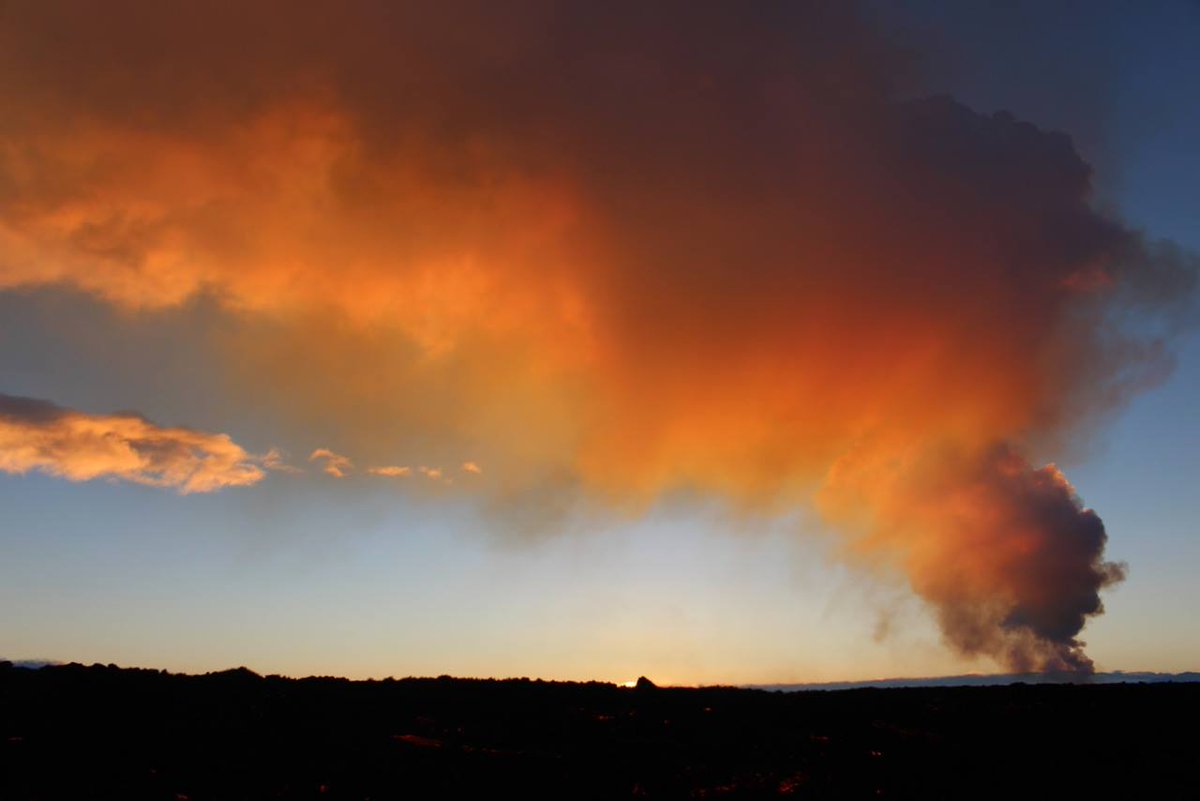
De eruptie gaat met grote kracht onverminderd door. De lavastroom en de gas-uitstoot is meer onderhevig aan veranderingen als voorheen.
Er zijn fluctuaties met een cyclus van enkele uren, en met een cyclus van 10-20 seconden.
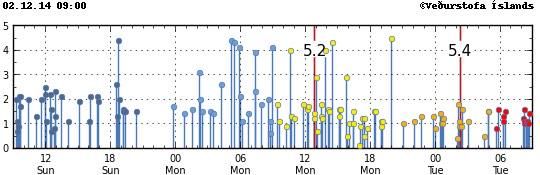
Ook de seismische activiteit in de Bardarbunga blijft sterk. ook vandaag weer een beving van 5.4.
De bevingen in de caldera lijken zch te concentreren in de bovenste 3 Km van de aardkorst. Dat betekent, dat de magma dichter bij de oppervlakte zit dan eerst werd aangenomen.
Het blijft onduidelijk hoe e.e.a. zich in de komende tijd gaat ontwikkelen.
Beelden van de Mila-webcam zijn weer spectaculair vanavond.
http://www.ijsland-enzo.n(...)spagina.asp?tabsel=0
Er zijn fluctuaties met een cyclus van enkele uren, en met een cyclus van 10-20 seconden.
Ook de seismische activiteit in de Bardarbunga blijft sterk. ook vandaag weer een beving van 5.4.
De bevingen in de caldera lijken zch te concentreren in de bovenste 3 Km van de aardkorst. Dat betekent, dat de magma dichter bij de oppervlakte zit dan eerst werd aangenomen.
Het blijft onduidelijk hoe e.e.a. zich in de komende tijd gaat ontwikkelen.
Beelden van de Mila-webcam zijn weer spectaculair vanavond.
http://www.ijsland-enzo.n(...)spagina.asp?tabsel=0
Verder rommelt het rustig verder:quote:Update
• The volcanic eruption in Holuhraun continues with similar intensity as last two weeks.
• Seismic activity in Bardarbunga continues to be strong. The biggest earthquake that was detected since noon on
Monday, was of magnitude M4,4 on Tuesday, 25. November at 23:26. Since noon on Monday 13 earthquakes larger then M3,0 and in total about 140 earthquakes were detected in Bardarbunga.
• About 20 earthquakes were detected in the dyke and around the eruption site in Holuhraun since Monday. The largest on was of magnitude M1,8.
• No signal is coming from the GPS station in the Bardarbunga caldera, the most likely explanation is icing on the antenna. A flight is scheduled over Bardarbunga today and new measurements of the depression are expected after that.

<a href="http://goo.gl/q8fhTe" target="_blank">FAQ?</a>
<a href="http://goo.gl/gYvZFq" target="_blank">Geel is een zonnige en vrolijke kleur, als hij tenminste enigszins warm is gekleurd en wat naar het oranje neigt</a>
<a href="http://goo.gl/gYvZFq" target="_blank">Geel is een zonnige en vrolijke kleur, als hij tenminste enigszins warm is gekleurd en wat naar het oranje neigt</a>
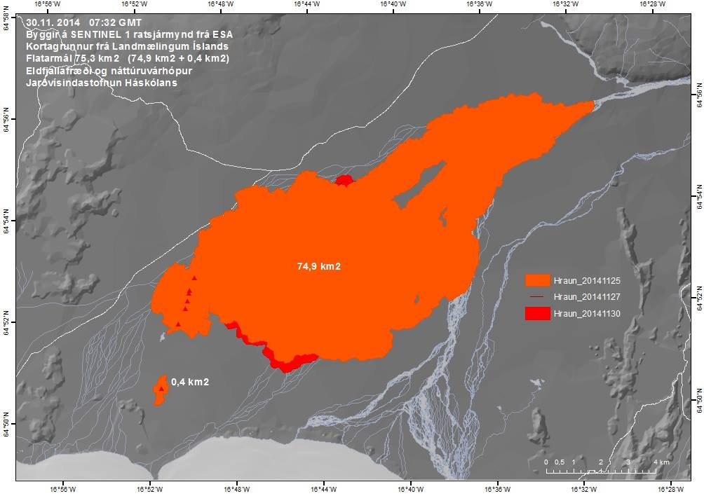
twitter:uni_iceland twitterde op donderdag 27-11-2014 om 11:35:51 The river of lava continues to expand the lava field. It's now almost 75 km2 http://t.co/iEjtiibvIF reageer retweet
 The river of lava continues to expand the lava field. It's now almost 75 km2
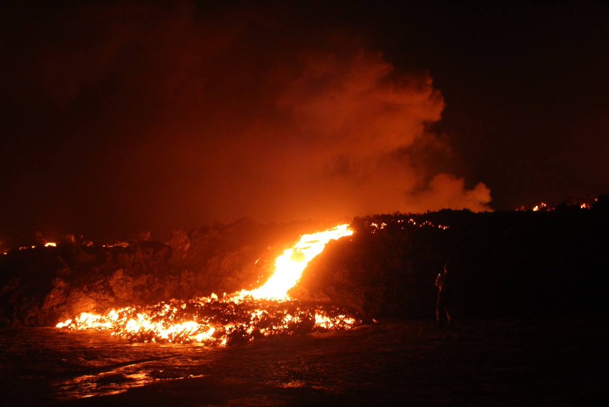
twitter:uni_iceland twitterde op donderdag 27-11-2014 om 11:34:57 The #Holuhraun eruption has been ongoing for almost three months. Picture by our field group taken yesterday, Nov 26 http://t.co/BuOSzNdJva reageer retweet
<a href="http://goo.gl/q8fhTe" target="_blank">FAQ?</a>
<a href="http://goo.gl/gYvZFq" target="_blank">Geel is een zonnige en vrolijke kleur, als hij tenminste enigszins warm is gekleurd en wat naar het oranje neigt</a>
<a href="http://goo.gl/gYvZFq" target="_blank">Geel is een zonnige en vrolijke kleur, als hij tenminste enigszins warm is gekleurd en wat naar het oranje neigt</a>
En weer een 5+
Instrumentarium voor het meten van de verzakking is nog steeds off-line
-----------
http://avd.is/en/wp-conte(...)arbunga_20141128.pdf
[ Bericht 18% gewijzigd door bwt op 28-11-2014 13:00:02 ]

Instrumentarium voor het meten van de verzakking is nog steeds off-line
-----------
http://avd.is/en/wp-conte(...)arbunga_20141128.pdf
quote:• Insubstantial changes have been on the volcanic eruption in Holuhraun over the last two weeks.
• Seismic activity in Bardarbunga continues to be strong. The biggest earthquake that was detected since noon on Wednesday, was of magnitude M5,1 this morning, 28. November at 06:41. Since noon on Wednesday 7 earthquakes larger then M4,0 were detected in Bardarbunga and 12 earthquakes between M3,0-3,9. In total about 170 earthquakes were detected in Bardarbunga since Wednesday.
• About 20 earthquakes were detected in the dyke and around the eruption site in Holuhraun since Wednesday. All of them were smaller then magnitude M1,0.
• About 20 earthquakes were detected in Tungnafellsjokull glacier since Wednesday. The biggest one was of magnitude M2,0.
• Scientists flew over Bardarbunga on Wednesday, 26. November. According to data collected in the flight the total depression of the Bardarbunga caldera is 50 meters and the total volume of the depression about 1,4 cubic kilometre since the seismic activity started in mid-August.
• No signal is coming from the GPS station in the Bardarbunga caldera, the most likely explanation is that the subsidence of the caldera is so great that the GPS station is now below the caldera rim and is therefore out of sight of the relay station in Kverkfjoll.
[ Bericht 18% gewijzigd door bwt op 28-11-2014 13:00:02 ]
<a href="http://goo.gl/q8fhTe" target="_blank">FAQ?</a>
<a href="http://goo.gl/gYvZFq" target="_blank">Geel is een zonnige en vrolijke kleur, als hij tenminste enigszins warm is gekleurd en wat naar het oranje neigt</a>
<a href="http://goo.gl/gYvZFq" target="_blank">Geel is een zonnige en vrolijke kleur, als hij tenminste enigszins warm is gekleurd en wat naar het oranje neigt</a>
Geen belangrijke ontwikkelingen. De uitbarsting gaat op dezelfde voet verder.
De reden, dat de verzakking van de caldera niet meer in de grafiek zichtbaar is, is dat door het zakken de GPS-apparatuur uit het zicht is gekomen van het relay-station voor het doorgeven van het signaal.
@IJslandenzo
De reden, dat de verzakking van de caldera niet meer in de grafiek zichtbaar is, is dat door het zakken de GPS-apparatuur uit het zicht is gekomen van het relay-station voor het doorgeven van het signaal.
@IJslandenzo
twitter:subglacial twitterde op zondag 30-11-2014 om 10:07:22 #Bárðarbunga caldera subsidence. Excellent graphic showing ice-covered caldera along with amount of subsidence. http://t.co/muIozr5gGb reageer retweet

twitter:subglacial twitterde op zondag 30-11-2014 om 10:19:59 #Bárðarbunga. Graphic showing the ice filled-covered caldera, along with subsidence graph. http://t.co/oAGlaOdqEQ http://t.co/EKK9A9DrW3 reageer retweet
twitter:subglacial twitterde op zondag 30-11-2014 om 10:29:46 #Bárðarbunga. Neat! Ice subsidence asymmetry (deeper in N) + main EQ activity also in the N. http://t.co/oAGlaOdqEQ http://t.co/3lJJncWWOk reageer retweet
<a href="http://goo.gl/q8fhTe" target="_blank">FAQ?</a>
<a href="http://goo.gl/gYvZFq" target="_blank">Geel is een zonnige en vrolijke kleur, als hij tenminste enigszins warm is gekleurd en wat naar het oranje neigt</a>
<a href="http://goo.gl/gYvZFq" target="_blank">Geel is een zonnige en vrolijke kleur, als hij tenminste enigszins warm is gekleurd en wat naar het oranje neigt</a>

Bronquote:• Insubstantial changes have been on the volcanic eruption in Holuhraun over the last two weeks.
• Seismic activity in Bardarbunga continues to be strong. The biggest earthquake that was detected since noon on Friday, was of magnitude M4,5 on Friday, 28. November at 22:52. Since noon on Friday 12 earthquakes larger then M4,0 were detected in Bardarbunga. In total about 200 earthquakes were detected in Bardarbunga since noon on Friday.
• About 10 earthquakes were detected in the dyke and around the eruption site in Holuhraun since Friday. All of them were smaller then magnitude M1,0. It is worth noting that the seismograph network is sensitive to wind so fewer smaller earthquakes are detected during a stormy weather like the one that has gone over Iceland in the last few days.
twitter:uni_iceland twitterde op maandag 01-12-2014 om 13:30:52 New map of #Holuhraun lava field. It's just over 75 km2 by now and keeps growing. #Bardarbunga keeps subsiding. http://t.co/ZbqUDWLpQV reageer retweet
[ Bericht 50% gewijzigd door bwt op 01-12-2014 14:16:24 ]
<a href="http://goo.gl/q8fhTe" target="_blank">FAQ?</a>
<a href="http://goo.gl/gYvZFq" target="_blank">Geel is een zonnige en vrolijke kleur, als hij tenminste enigszins warm is gekleurd en wat naar het oranje neigt</a>
<a href="http://goo.gl/gYvZFq" target="_blank">Geel is een zonnige en vrolijke kleur, als hij tenminste enigszins warm is gekleurd en wat naar het oranje neigt</a>
twitter:subglacial twitterde op maandag 01-12-2014 om 14:15:49 And after 50+ hours of being quiet, the #Bárðarbunda caldera starts shaking again. Love it! http://t.co/eMqFzbPn7t reageer retweet


twitter:volcan01010 twitterde op maandag 01-12-2014 om 14:52:48 #Bardarbunga Science board: http://t.co/AnLfogCCy9 Caldera subsidence rate 130m3/s (was 200m3/s in Sept). M4.5 EQ Fri. #Holuhraun continues. reageer retweet

[ Bericht 24% gewijzigd door bwt op 01-12-2014 15:00:06 ]
<a href="http://goo.gl/q8fhTe" target="_blank">FAQ?</a>
<a href="http://goo.gl/gYvZFq" target="_blank">Geel is een zonnige en vrolijke kleur, als hij tenminste enigszins warm is gekleurd en wat naar het oranje neigt</a>
<a href="http://goo.gl/gYvZFq" target="_blank">Geel is een zonnige en vrolijke kleur, als hij tenminste enigszins warm is gekleurd en wat naar het oranje neigt</a>
twitter:almannavarnir twitterde op dinsdag 02-12-2014 om 17:07:00 EO-1 ALI thermographic image from NASA and edited by @uni_iceland the volcanic eruption in Holuhraun #Bardarbunga http://t.co/vtAqrC4nCJ reageer retweet
 EO-1 ALI thermographic image from NASA and edited by @
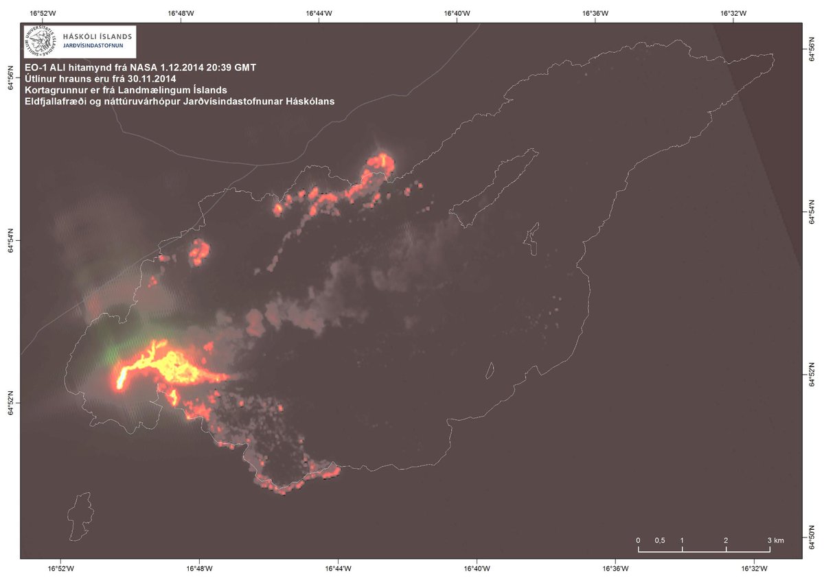
<a href="http://goo.gl/q8fhTe" target="_blank">FAQ?</a>
<a href="http://goo.gl/gYvZFq" target="_blank">Geel is een zonnige en vrolijke kleur, als hij tenminste enigszins warm is gekleurd en wat naar het oranje neigt</a>
<a href="http://goo.gl/gYvZFq" target="_blank">Geel is een zonnige en vrolijke kleur, als hij tenminste enigszins warm is gekleurd en wat naar het oranje neigt</a>
Univ. of Iceland
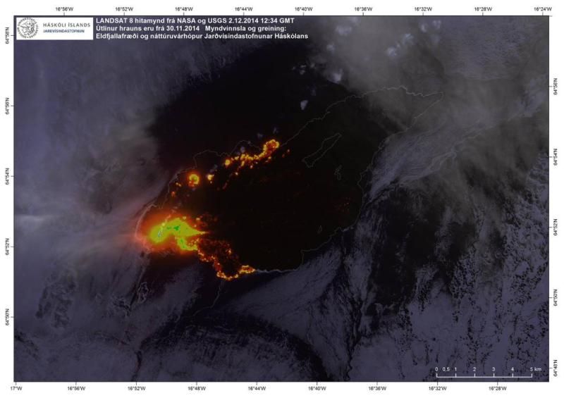
Satellite image taken at noon today (yes, it's getting pretty dark up here) of #Holuhraun eruption #Bardarbunga http://t.co/e07CKiCO1R
[ Bericht 39% gewijzigd door #ANONIEM op 02-12-2014 19:32:09 ]
Satellite image taken at noon today (yes, it's getting pretty dark up here) of #Holuhraun eruption #Bardarbunga http://t.co/e07CKiCO1R
[ Bericht 39% gewijzigd door #ANONIEM op 02-12-2014 19:32:09 ]
Mooie "interactieve" gas verspreiding voor/over de komende dagen.
http://en.vedur.is/weather/forecasts/gas-model/twitter:janinekrippner twitterde op woensdag 03-12-2014 om 12:20:03 Check out the interactive gas dispersal (SO2) map for the Holuhraun eruption, Iceland http://t.co/y0nEuFGFvN http://t.co/HfmzM7lfet reageer retweet
 Check out the interactive gas dispersal (SO2) map for the Holuhraun eruption, Iceland
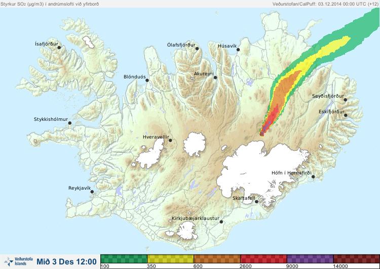
<a href="http://goo.gl/q8fhTe" target="_blank">FAQ?</a>
<a href="http://goo.gl/gYvZFq" target="_blank">Geel is een zonnige en vrolijke kleur, als hij tenminste enigszins warm is gekleurd en wat naar het oranje neigt</a>
<a href="http://goo.gl/gYvZFq" target="_blank">Geel is een zonnige en vrolijke kleur, als hij tenminste enigszins warm is gekleurd en wat naar het oranje neigt</a>
The volcanic eruption in Holuhraun has lasted for 100 days
The Scientific Advisory Board of the Icelandic Civil Protection met yesterday, 8. December, as it does regularly three days a week. The scenarios, for the most likely development of the volcanic eruption in Holuhraun and the subsidence of Bardarbunga caldera, were reviewed at the meeting. As all devoted readers of our notes (published here) know, the Scientific Advisory Board recently concluded that the most likely development of the volcanic eruption, given the course of events until now, would be for it to continue for few months more. The eruption, which started on 31st of August, has now lasted for 100 days. A good overview of the eruption until now can be read here.
Below are the main points from the Scientific Advisory Board meeting yesterday and the updated scenarios. At the bottom of the page is an satellite image from ESA showing the lava field on December 5. The image is edited by the Institute of Earth Sciences, University of Iceland.
http://avd.is/en/?p=735
Facktsheet
[ Bericht 17% gewijzigd door bwt op 10-12-2014 13:21:34 ]
Wat ik niet terug vind is de SO2 uitstoot.quote:• Insubstantial changes have been in the volcanic eruption in Holuhraun over the last few weeks. The lava is now also flowing towards east northeast into the small island in the centre of the lava field. This change can be seen from web cameras.
• Seismic activity in Bardarbunga continues to be strong. The strongest earthquake since noon on Monday, 8. December, was magnitude M4,9 on Tuesday at 18:00. About 20 earthquakes larger then M3,0 were detected since Monday. In total about 180 earthquakes were detected in Bardarbunga since noon on Monday.
• Little seismic activity was detected in the dyke and around the eruption site in Holuhraun since Monday. It worth noting that the storm, now going over Iceland, reduces the sensitivity of the seismograph system, making it harder to detect small earthquakes.
• GPS measurements show no changes. The subsidence towards Bardarbunga continues with similar rate as has been.
• Telecommunications with the GPS station in Bardarbunga caldera have not been established yet. Due to bad weather forecast it is unlikely that scientists will be able to travel to Bardarbunga in the next few days. A connection will be established with the GPS station as soon as possible.
twitter:subglacial twitterde op woensdag 10-12-2014 om 10:39:08 #Bárðarbunga Great map showing growth of the #Nornahraun lava field. Fascinating! From http://t.co/oAGlaOdqEQ http://t.co/KMzLifAXra reageer retweet

[ Bericht 17% gewijzigd door bwt op 10-12-2014 13:21:34 ]
<a href="http://goo.gl/q8fhTe" target="_blank">FAQ?</a>
<a href="http://goo.gl/gYvZFq" target="_blank">Geel is een zonnige en vrolijke kleur, als hij tenminste enigszins warm is gekleurd en wat naar het oranje neigt</a>
<a href="http://goo.gl/gYvZFq" target="_blank">Geel is een zonnige en vrolijke kleur, als hij tenminste enigszins warm is gekleurd en wat naar het oranje neigt</a>
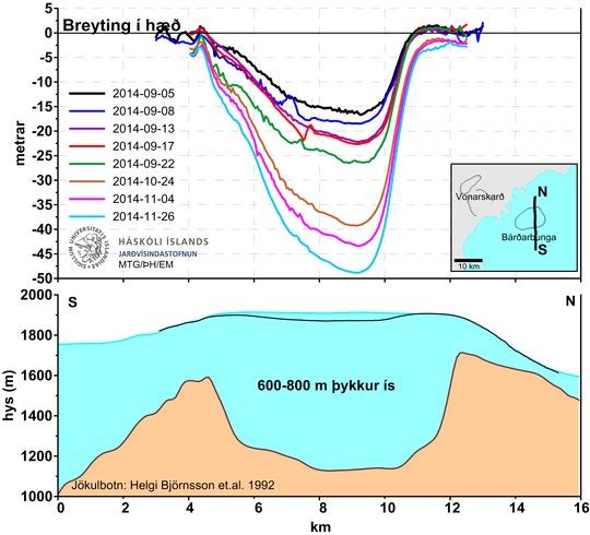
Overzicht van de beschikbare data van het begin van de Bardarbunga-onrust tot vandaag.
De meeste data laat een teruggang zien in de verzakking van de caldera en teruggang in de uitbarsting zelf.
Aardbevingsactiviteit is echter sterk, en de lavastroom groot in vergelijking mat de uitbarstingen op IJsland in de laatste 100 jaar.
De conclusies zijn de volgende:
Aardbevingen in Bardarbunga: Seismische activiteit is zeer hevig sinds half augustus, met een piek in de eerste helft van september. Daarna is de activiteit iets afgenomen, maar blijft hevig. De periode van seismische onrust is één van de grootste die ooit wereldwijd is gemeten.
Aardbevingen in de dijk van Bardarbunga naar Holuhraun: Veel activiteit tijdens het tot stand komen van de dijk in de tweede helft van augustus, maar dit nam af sinds de start van de uitbarsting in Holuhraun. Er komen hier nog steeds aardbevingen voor, maar de kracht is klein en het aantal is relatief laag.
Verzakking van de caldera: Vanaf het begin van de seismische onrust verzakte de caldera 80cm/dag, maar is afgezwakt naar 25cm/dag op dit moment. De verzakking is met 50 meter het grootst in het midden van de caldera, maar minder aan de randen.
De uitbarsting in Holuhraun: De eruptie, die begon op 31 augustus wordt gekarakteriseerd door een grote en ongewoon stabiele lavastroom. De lava is van een primitieve basaltsoort, met een chemische samenstelling karakteristiek voor het Bardarbunga vulkanische systeem. De analyse van de magma lijkt aan te tonen, dat de magma rechtstreeks komt van een diepte van 9-20 Km.
Het lavaveld is nu 76 Km2. Het volume is moelijk te meten, maar metingen van 4 en 26 november geven een huidige waarde van 1Km3, met een marge van + of - 0.3 Km3.
De lavastroom startte met 200m3/sec in september, maar zit nu onder de 100m3/sec.
Het nieuwe lavaveld is op IJsland het grootste sinds de Laki-uitbarsting en het 2-na grootste ter wereld in diezelfde periode.
Gas: Voor het eerst in 150 jaar heeft de gasvervuiling een impact op IJsland. De reden is de grootte en de duur van de uitbarsting. De uitstoot piekte op 1300 Kg/sec. maar is gemiddeld 400 Kg/sec. Metingen van de totale uitstoot zijn moelijk en de onnauwkeurigheid van deze waarde is zeer groot.
Het is aannemelijk dat de gasproductie afneemt naarmate de lavastroom afneemt. De laatste paar weken zijn hoge concentraties gemeten in bewoonde gebieden, vergeleken met de period in september en oktober, maar wind- en weersomstandigheden hadden op deze waarden veel effect.
Als de onrust op de huidige wijze doorgaat, kan zowel de verzakking van de caldera als de uitbarsting nog maanden doorgaan.
Scenario's met uitbarstingen ónder de gletsjer zoals eerder aangegeven zijn nog steeds mogelijk.
http://www.ijsland-enzo.n(...)spagina.asp?tabsel=0
Posts aanpassen geeft best problemen
[ Bericht 100% gewijzigd door bwt op 14-12-2014 12:01:51 ]
[ Bericht 100% gewijzigd door bwt op 14-12-2014 12:01:51 ]
<a href="http://goo.gl/q8fhTe" target="_blank">FAQ?</a>
<a href="http://goo.gl/gYvZFq" target="_blank">Geel is een zonnige en vrolijke kleur, als hij tenminste enigszins warm is gekleurd en wat naar het oranje neigt</a>
<a href="http://goo.gl/gYvZFq" target="_blank">Geel is een zonnige en vrolijke kleur, als hij tenminste enigszins warm is gekleurd en wat naar het oranje neigt</a>
twitter:iurie_iceland twitterde op vrijdag 12-12-2014 om 20:04:11 Holuhraun. I love #aerial #photography. #iceland #nature #volcano #eruption #travel @500px @natgeo @adorama http://t.co/2HAntvgomd reageer retweet
 Holuhraun. I love
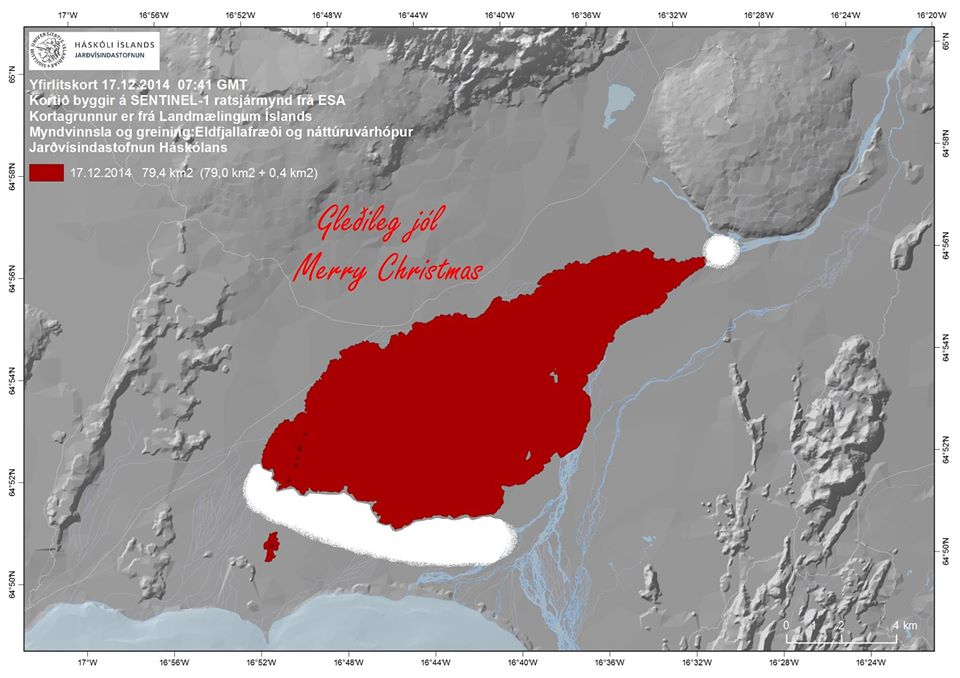
twitter:uni_iceland twitterde op vrijdag 12-12-2014 om 18:24:46 "It's getting (bigger) all the tiiiime“ New map of the lave field show's it's ~79 km2. #TheBeatles #Bardarbunga http://t.co/iq38kV7p86 reageer retweet

<a href="http://goo.gl/q8fhTe" target="_blank">FAQ?</a>
<a href="http://goo.gl/gYvZFq" target="_blank">Geel is een zonnige en vrolijke kleur, als hij tenminste enigszins warm is gekleurd en wat naar het oranje neigt</a>
<a href="http://goo.gl/gYvZFq" target="_blank">Geel is een zonnige en vrolijke kleur, als hij tenminste enigszins warm is gekleurd en wat naar het oranje neigt</a>
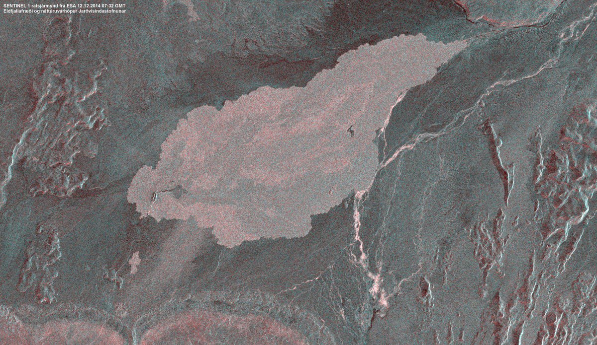
twitter:uni_iceland twitterde op vrijdag 12-12-2014 om 16:23:19 @ESA SENTINEL-1 image of #Holuhraun this morning. The "island" that used to be in the lava field is now covered. http://t.co/deZDiyIwd1 reageer retweet
<a href="http://goo.gl/q8fhTe" target="_blank">FAQ?</a>
<a href="http://goo.gl/gYvZFq" target="_blank">Geel is een zonnige en vrolijke kleur, als hij tenminste enigszins warm is gekleurd en wat naar het oranje neigt</a>
<a href="http://goo.gl/gYvZFq" target="_blank">Geel is een zonnige en vrolijke kleur, als hij tenminste enigszins warm is gekleurd en wat naar het oranje neigt</a>

Via Twitter @uni_iceland
Old moderators never die, they just smell that way!
Op dinsdag 5 januari 2010 20:40 schreef nokwanda het volgende:
En natuuuuuurlijk was jij dat weer. Smeerpijp dat je der bent :P _O-
Bullie is thuis X-Rated Epic fail
Op dinsdag 5 januari 2010 20:40 schreef nokwanda het volgende:
En natuuuuuurlijk was jij dat weer. Smeerpijp dat je der bent :P _O-
Bullie is thuis X-Rated Epic fail
twitter:uni_iceland twitterde op donderdag 18-12-2014 om 20:33:13 The lava from #Holuhraun eruption covers ~80 km2 by now. It reminded us of something… #Bardarbunga http://t.co/Sw3cjh6jSL reageer retweet
• Insubstantial changes have been in the volcanic eruption in Holuhraun over the last few weeks. Indication show that the lava is now mainly flowing inside closed channels except closest to the crater. One of the main lava channels is now flowing to the north.
• Seismic activity in Bardarbunga continues to be strong. The strongest earthquake since noon on Tuesday, 17. December, was magnitude M5,3 on Wednesday, 17. December, at 13:59 on the northern rim of the caldera. The earthquake was felt in Akureyri. About 6 earthquakes between M4,0-5,0 were detected since Tuesday. In total about 200 earthquakes were detected in Bardarbunga since noon on Tuesday.
• About 20 earthquakes were detected in the dyke and around the eruption site in Holuhraun since Tuesday. All smaller then magnitude M2,0.
• GPS measurements near northern Vatnajokull glacier show continuing slow subsidence towards Bardarbunga. The rate of the subsidence has slowly decreased.
• Yesterday, 18. December, scientists flew over Bardarbunga. The data collected in the flight show that the subsidence of the caldera continues with similar rate as before. The caldera has subsided between 4-5 meters since 4. December and the south caldera rim has subsided between 7-8 meters since the beginning of the seismic activity in August.
• Telecommunications with the GPS station in Bardarbunga caldera have not been established yet. Due to bad weather forecast it is unlikely that scientists will be able to travel to Bardarbunga in the next few days. A connection will be established with the GPS station as soon as possible.
[ Bericht 38% gewijzigd door bwt op 19-12-2014 13:51:52 ]
<a href="http://goo.gl/q8fhTe" target="_blank">FAQ?</a>
<a href="http://goo.gl/gYvZFq" target="_blank">Geel is een zonnige en vrolijke kleur, als hij tenminste enigszins warm is gekleurd en wat naar het oranje neigt</a>
<a href="http://goo.gl/gYvZFq" target="_blank">Geel is een zonnige en vrolijke kleur, als hij tenminste enigszins warm is gekleurd en wat naar het oranje neigt</a>
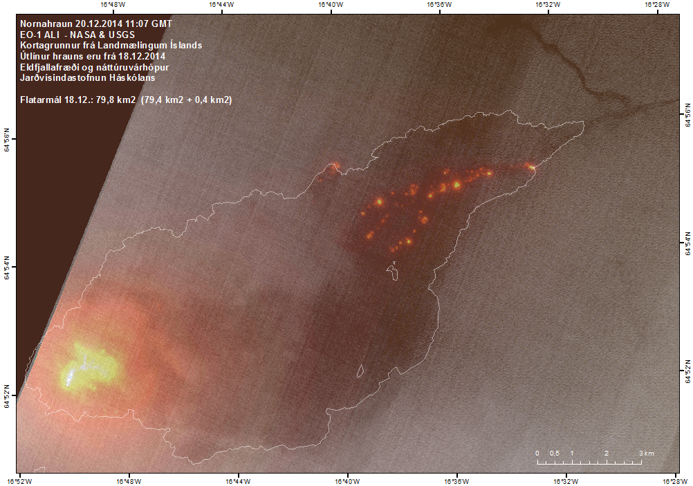
twitter:janinekrippner twitterde op maandag 22-12-2014 om 10:29:03 USGS/NASA thermal image showing active lava 15 km NE from vent. Taken Dec. 20. http://t.co/7NPRM2ZXuu reageer retweet
• Insubstantial changes have been in the volcanic eruption in Holuhraun over the last few weeks. The lava is now flowing inside a closed channel to the eastern edge of the lava field, about 15 km from the crater. Lava is also running to the north.
• Seismic activity in Bardarbunga continues to be strong, but it has though somewhat decreased. The strongest earthquake since noon on Friday, 19. December, was magnitude M4,5 yesterday, 21. December, at 16:12 on the southern rim of the caldera. Six earthquakes larger then M4,0 were detected since Friday and about 25 earthquakes between M3,0-4,0. In total about 135 earthquakes were detected in Bardarbunga since noon on Friday.
• Eighteen earthquakes were detected in the dyke and around the eruption site in Holuhraun since Friday. All smaller then magnitude M2,0.
• GPS measurements near northern Vatnajokull glacier show continuing slow subsidence towards Bardarbunga. The rate of the subsidence has slowly decreased.
• Telecommunications with the GPS station in Bardarbunga caldera have not been established yet. Due to bad weather, over the last few weeks, scientists have not able to travel to Bardarbunga. It is unlikely that any attempt will be made to fix the GPS station until after the holidays.
twitter:David_Bressan twitterde op maandag 22-12-2014 om 14:36:40 #AwesomeGeology2014 Dear journalists, remember all that hype about Bárðarbunga / Holuhraun? No mention at all now? #hypocrisy reageer retweet

<a href="http://goo.gl/q8fhTe" target="_blank">FAQ?</a>
<a href="http://goo.gl/gYvZFq" target="_blank">Geel is een zonnige en vrolijke kleur, als hij tenminste enigszins warm is gekleurd en wat naar het oranje neigt</a>
<a href="http://goo.gl/gYvZFq" target="_blank">Geel is een zonnige en vrolijke kleur, als hij tenminste enigszins warm is gekleurd en wat naar het oranje neigt</a>
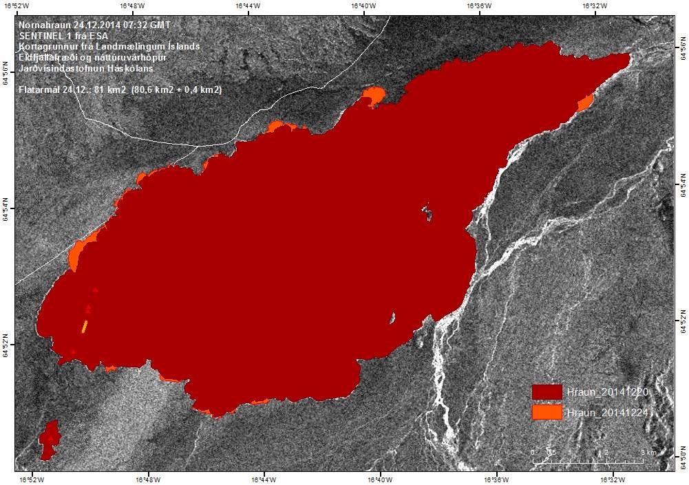
twitter:uni_iceland twitterde op donderdag 25-12-2014 om 17:10:45 We're not the only ones gaining weight this time of year. The #Holuhraun lava field keeps growing. Now ~81 km2 http://t.co/gThaBWFzBF reageer retweet
-------------------
• Insubstantial changes have been in the volcanic eruption in Holuhraun over the last few weeks. The lava is now flowing inside a closed channel to the eastern edge of the lava field, about 15 km from the crater. Lava is also running to the north.
• Seismic activity in Bardarbunga continues to be strong, but it has though somewhat decreased. The strongest earthquake over the last two days was detected tonight, 30. December, was magnitude M5,3 at 00:11. Eleven earthquakes larger then M3,0 were detected since noon on Sunday and in total around 100 earthquakes were detected in Bardarbunga since noon on Sunday.
• GPS measurements near northern Vatnajokull glacier show continuing slow deflation towards Bardarbunga.
• Telecommunications with the GPS station in Bardarbunga caldera have not been established yet.
<a href="http://goo.gl/q8fhTe" target="_blank">FAQ?</a>
<a href="http://goo.gl/gYvZFq" target="_blank">Geel is een zonnige en vrolijke kleur, als hij tenminste enigszins warm is gekleurd en wat naar het oranje neigt</a>
<a href="http://goo.gl/gYvZFq" target="_blank">Geel is een zonnige en vrolijke kleur, als hij tenminste enigszins warm is gekleurd en wat naar het oranje neigt</a>
Het GPS station in de caldera is inmiddels ook weer bereikbaar
[ Bericht 23% gewijzigd door bwt op 05-01-2015 10:28:29 ]


quote:Other discoveries
Scientists have discovered that dyke activity in Bárðarbunga volcano appears to be creating new layers of crust at depth. I don’t have the details on this , I did see this in the news few days ago, but I lost the news about what this is exactly about. I hope to get more details later about this.
twitter:uni_iceland twitterde op maandag 05-01-2015 om 10:26:55 LANDSAT 8 satellite image from NASA & USGS showing the lava flows from #Holuhraun eruption. Still going strong http://t.co/caaohQnRgR reageer retweet
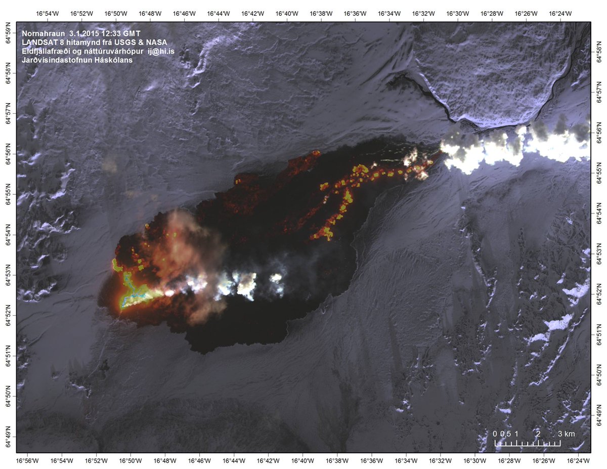
[ Bericht 23% gewijzigd door bwt op 05-01-2015 10:28:29 ]
<a href="http://goo.gl/q8fhTe" target="_blank">FAQ?</a>
<a href="http://goo.gl/gYvZFq" target="_blank">Geel is een zonnige en vrolijke kleur, als hij tenminste enigszins warm is gekleurd en wat naar het oranje neigt</a>
<a href="http://goo.gl/gYvZFq" target="_blank">Geel is een zonnige en vrolijke kleur, als hij tenminste enigszins warm is gekleurd en wat naar het oranje neigt</a>