WKN Weer, Klimaat en Natuurrampen
Lees alles over het onstuimige weer op onze planeet, volg orkanen en tornado's, zie hoe vulkanen uitbarsten en hoe Moeder Aarde beeft bij een aardbeving. Alles over de verwoestende kracht van onze planeet en tal van andere natuurverschijnselen.


El Golfo, El Hierro, De plek waar de meeste aardbevingen zijn geregistreerd
[/quote]quote:El Hierro’s Volcanic/Seismic Past
El Hierro is situated in the most southwestern extreme of the Canaries. The island was formed after three successive eruptions, and consequent accumulations, the island emerged from the ocean as an imposing triangular pyramid crowned by a volcano more than 2,000 metres high.
The volcanic activity, principally at the convergence of the three ridges, resulted in the continual expansion of the island. A mere 50,000 years ago, as a result of seismic tremors which produced massive landslides, a giant piece of the island cracked off, crashed down into the ocean and scattered along the seabed. This landslide of more than 300km3 gave rise to the impressive amphitheatre of the El Golfo valley and at the same time caused a tsunami that most likely rose over 100 metres high and probably reached as far as the American coast.
(enkele video's zijn in de OP's van het vorige topics te vinden)
Status Vandaag de dag:
De afgelopen dagen is er wederom (net als de start van het vorige topic) grote activiteit geweest op het eiland. Er zijn weer sterke "vervormingen" zoals het omhoog komen van enkele cm's van een groot deel van het eiland. Daarbij is er ook nog een verplaatsing van een paar cm van noord en zuidkant van het eiland - weg van de plek van de "vervorming".

Zware aardbeving
Als gevolg van de vele activiteit de afgelopen jaren is ten noord-westen van het eiland een zware aardbeving geweest van 5.1
Hoeveel bevingen zijn er geweest sinds de start in 2011?
Zie het bij behorende plaatje:

disclaimer - het plaatje is voor het laatst geactualiseerd in augustus - we leven nu eind december
Links
Live webcams op het eiland El Hierro (niet alles werkt meer)
Zelfde webcams via andere link
Actuele seismische activiteit
AVCan - vulcanologiesch instituut Canarische eilanden
Spaans geografisch instituut
INVOLCAN Facebook pagina
AVCAN facebook pagina
Canariesnews
Tumbit
en op twitter kun je zoeken op #hierro, #elhierro of #viveelhierro
@noticiacanaria Wel veel ander nieuws
@canariesnews
@eruptionsblog
@teideano 1 van de onderzoekers op El Hierro
Gerelateerde topics
WKN / [Vulkanen] The ring of fire #6: Waar diverse vulkanen puffen
WKN / Aardbevingen #16
WKN / Mega tsunami door in zee vallen van eiland La Palma?
eerdere delen
WKN / [breaking] Vulkaanuitbarsting bij Canarische Eilanden
WKN / [breaking] Vulkaanuitbarsting bij Canarische Eilanden #2
WKN / [aktueel] Vulkaanuitbarsting bij Canarische Eilanden #3
WKN / Vulkaanuitbarsting bij Canarische Eilanden #4
WKN / Vulkaanuitbarsting bij Canarische Eilanden #5
[ Bericht 2% gewijzigd door bwt op 28-12-2013 14:24:37 ]
<a href="http://goo.gl/q8fhTe" target="_blank">FAQ?</a>
<a href="http://goo.gl/gYvZFq" target="_blank">Geel is een zonnige en vrolijke kleur, als hij tenminste enigszins warm is gekleurd en wat naar het oranje neigt</a>
<a href="http://goo.gl/gYvZFq" target="_blank">Geel is een zonnige en vrolijke kleur, als hij tenminste enigszins warm is gekleurd en wat naar het oranje neigt</a>
twitter:
 Inflation at El Hierro still up O_O. 6,5cm at some gps stations.
 quote:2013-12-28 13:11 UTC
The first satellite image (Modis Terra satellite) has too much clouds above yesterdays epicenter area to determine color differences in the ocean (the ocean is colored light blue on this location, but these spots are probably clouds). There is another satellite image coming shortly from the Modis Aqua satellite. So hang on to see the latest details.
Click on the link to see it in full size (your computer will need some time to load it!)

<a href="http://goo.gl/q8fhTe" target="_blank">FAQ?</a>
<a href="http://goo.gl/gYvZFq" target="_blank">Geel is een zonnige en vrolijke kleur, als hij tenminste enigszins warm is gekleurd en wat naar het oranje neigt</a>
<a href="http://goo.gl/gYvZFq" target="_blank">Geel is een zonnige en vrolijke kleur, als hij tenminste enigszins warm is gekleurd en wat naar het oranje neigt</a>
Zoals eerder gezegd is dat La Palma idd. Daar heb je de Cumbre Vieja vulkaan die voor het laatst in 1971 was uitgebarsten. In 1949 zorgde dat voor een verzakking van een deel van het eiland, dus het zaakje zou aardig instabiel kunnen zijn.quote:Op zaterdag 28 december 2013 11:37 schreef Scrummie het volgende:
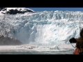
Dit is toch het eiland dat een mega tsunami veroorzaakt als er wat afbreekt ofzo?
Waar je het mee zou kunnen vergelijken, op een veel kleinere schaal, is een kalvende gletsjer:
(vanaf ongeveer 1:35 begint het spectakel)
twitter:etnaboris twitterde op zaterdag 28-12-2013 om 18:32:04 @CultureVolcan @magmatters Radon is not a gas that comes from the magma, but which comes from the uppermost few meters of the soil (1/2) reageer retweet
 @CultureVolcan @
En waar is dit op gebaseerd?twitter:etnaboris twitterde op zaterdag 28-12-2013 om 18:32:45 @CultureVolcan @magmatters Radon is released when the ground is subjected to fracturing (induced, e.g., by inflation or seismicity) (2/2) reageer retweet
Nou - Hierop:
twitter:teideano twitterde op zaterdag 28-12-2013 om 02:14:39 222Rn measurements at one of our stations in El Hierro.Precursory activity b4 the earthquake? #volcano #science http://t.co/9prar7IssE reageer retweet

<a href="http://goo.gl/q8fhTe" target="_blank">FAQ?</a>
<a href="http://goo.gl/gYvZFq" target="_blank">Geel is een zonnige en vrolijke kleur, als hij tenminste enigszins warm is gekleurd en wat naar het oranje neigt</a>
<a href="http://goo.gl/gYvZFq" target="_blank">Geel is een zonnige en vrolijke kleur, als hij tenminste enigszins warm is gekleurd en wat naar het oranje neigt</a>
Aftermath van de 5.1 / 5.3 beving.
Video en plaatjes.
(gekkepoes had nog een linkje gestuurd.)
Video en plaatjes.
(gekkepoes had nog een linkje gestuurd.)
twitter:teideano twitterde op zondag 29-12-2013 om 03:03:18 http://t.co/gzWAOpC28c Amazing video of El Hierro #quake #volcano #geology #nature #wow reageer retweet

twitter:teideano twitterde op zaterdag 28-12-2013 om 02:55:54 Multiple Rockfalls at El Hierro. #volcano #earthquake #geology via Inma Guedes,http://t.co/007CcpwzCm http://t.co/oCBYhUxN71 reageer retweet

twitter:teideano twitterde op zondag 29-12-2013 om 11:52:09 Aftermath of the 5.3 quake at El Hierro. Pic from Yera Ds. #volcano #geology #nature http://t.co/riu9tyhFvj reageer retweet

twitter:teideano twitterde op zondag 29-12-2013 om 11:53:26 Aftermath of the 5.3 quake at El Hierro. Pic from Yera Ds. #volcano #geology #nature http://t.co/tftuqiR4Yb reageer retweet

<a href="http://goo.gl/q8fhTe" target="_blank">FAQ?</a>
<a href="http://goo.gl/gYvZFq" target="_blank">Geel is een zonnige en vrolijke kleur, als hij tenminste enigszins warm is gekleurd en wat naar het oranje neigt</a>
<a href="http://goo.gl/gYvZFq" target="_blank">Geel is een zonnige en vrolijke kleur, als hij tenminste enigszins warm is gekleurd en wat naar het oranje neigt</a>
Er is een website / blog die een wel erg foute titel heeft:
http://www.wunderground.c(...)no-eruption-20131228
Het gaat hier niet om el-hierro maar om de vulkaan uitbarsting van el salvador Chaparrastique vulkaan.
Van de afgelopen 15 dagen
En van de afgelopen 36 uur
[ Bericht 18% gewijzigd door bwt op 30-12-2013 14:30:23 ]
http://www.wunderground.c(...)no-eruption-20131228
Het gaat hier niet om el-hierro maar om de vulkaan uitbarsting van el salvador Chaparrastique vulkaan.
twitter:VolcanoReport twitterde op maandag 30-12-2013 om 09:51:31 El #Hierro #Volcano Crisis: New data showing changing (but still present) deformations - http://t.co/8YJ4WxbHdK http://t.co/bfjOAPmCNM reageer retweet

twitter:teideano twitterde op maandag 30-12-2013 om 11:00:14 El Hierro still inflating, no seismicity detected. Up to 8.3 cm at some sites, strange behaviour. #volcano #geology http://t.co/eQU9rI7tEx reageer retweet

Plaatje van alle bevingen tot nu toe uit de OP bijgewerkt. Laat nu ook van augustus tot nu toe zien.quote:2013-12-30 08:03 UTC
NO more earthquakes, very calm graphs but again spectacular deformation charts.
Deformations are giving a totally changed pattern this morning. The Southern areas are subsiding. The eastern central area is stabilizing BUT the western central and northern areas are inflating (western area very strong). HI10 (El Julan) has no data for the second day in a row. The changing deformation pattern shows the biggest magma movement below the island concentrating in the El Golfo area (Sabinosa to Frontera) and is an additional sign that the crisis isnt over yet.
The strongest deformation today is noted in Sabinosa (GPS station HI03) where the ground was lifted 3 cm in less than 24 hours. The station HI04 (slightly west of HI03 (see map) has however stabilized data.
This crisis will only end when the deformations are stabilizing everywhere.
Van de afgelopen 15 dagen

En van de afgelopen 36 uur

[ Bericht 18% gewijzigd door bwt op 30-12-2013 14:30:23 ]
<a href="http://goo.gl/q8fhTe" target="_blank">FAQ?</a>
<a href="http://goo.gl/gYvZFq" target="_blank">Geel is een zonnige en vrolijke kleur, als hij tenminste enigszins warm is gekleurd en wat naar het oranje neigt</a>
<a href="http://goo.gl/gYvZFq" target="_blank">Geel is een zonnige en vrolijke kleur, als hij tenminste enigszins warm is gekleurd en wat naar het oranje neigt</a>
Ben benieuwd wat de berichtgeving van vandaag zal geven.
Het lijkt er namelijk wel heel erg sterk op dat alle registratie stations weer aan het zakken zijn.
BEHALVE HI10.
Het lijkt er namelijk wel heel erg sterk op dat alle registratie stations weer aan het zakken zijn.
BEHALVE HI10.
<a href="http://goo.gl/q8fhTe" target="_blank">FAQ?</a>
<a href="http://goo.gl/gYvZFq" target="_blank">Geel is een zonnige en vrolijke kleur, als hij tenminste enigszins warm is gekleurd en wat naar het oranje neigt</a>
<a href="http://goo.gl/gYvZFq" target="_blank">Geel is een zonnige en vrolijke kleur, als hij tenminste enigszins warm is gekleurd en wat naar het oranje neigt</a>
Inderdaad:
De tremor en bevingen zijn nog niet helemaal weg hoor:
Overzicht van wat waar beeft
Afgelopen 36 uur:
Afgelopen 15 dagen
quote:2013-12-31 08:52 UTC
What we had expected last night was confirmed this morning by the new deformation data : a general subsidence (deflation) of the island (remark : a couple of signals – HI01 and HI10 – were not updated).
Frontera had a 1 day deflation of 4 cm!.
Yesterday we saw the last tremor disappear from various seismographs. Tremor is the indication that magma is moving somewhere below the island.
The 2 new earthquakes have no special meaning as they will be probably generated by deformation stress and not by magma stress or movement. This will certainly happen more the next few days.
How long will it take to the next crisis ? Nobody knows as it can happen tomorrow or next year, but scientists are convinced that more activity periods will follow.
We were once again happily surprised by the many people following this crisis via earthquake-report.com. We will continue this report also in the future. Please continue to send a comment when you see something irregular on one of the seismographs.


De tremor en bevingen zijn nog niet helemaal weg hoor:

Overzicht van wat waar beeft
Afgelopen 36 uur:

Afgelopen 15 dagen

<a href="http://goo.gl/q8fhTe" target="_blank">FAQ?</a>
<a href="http://goo.gl/gYvZFq" target="_blank">Geel is een zonnige en vrolijke kleur, als hij tenminste enigszins warm is gekleurd en wat naar het oranje neigt</a>
<a href="http://goo.gl/gYvZFq" target="_blank">Geel is een zonnige en vrolijke kleur, als hij tenminste enigszins warm is gekleurd en wat naar het oranje neigt</a>
En ja hoor, we gaan nog lekker actief het nieuwe jaar in.
quote:2014-01-01 13:23 UTC
Renewed increasing tremor is visible in the El Golfo area (TAB en TAN seismographs). Remember that we mentioned this morning that HI04 Sabinosa area GPS station had an increase of at least 2 cm during the last 24 hours.
2014-01-01 10:44 UTC
4 earthquakes since our latest update. The M2.1 at 3 km depth earthquake was located to the south of La Restinga in the Las Calmas sea
Ecxept for the HI04 GPS (Sabinosa) who shows a lifting of 2 cm, almost all the other stations stabilizes based on the new IGN deformation data.
Link to graph of HI00; HI08, HI09 and HI10
Link to graph of HI01, FRON, HI02, HI03 and HI04

<a href="http://goo.gl/q8fhTe" target="_blank">FAQ?</a>
<a href="http://goo.gl/gYvZFq" target="_blank">Geel is een zonnige en vrolijke kleur, als hij tenminste enigszins warm is gekleurd en wat naar het oranje neigt</a>
<a href="http://goo.gl/gYvZFq" target="_blank">Geel is een zonnige en vrolijke kleur, als hij tenminste enigszins warm is gekleurd en wat naar het oranje neigt</a>
1252804 01/01/2014 23:12:31 27.6679 -18.2876 17 1.9 4 SW FRONTERA.IHIquote:2014-01-02 09:00 UTC
NO new deformation data yet.
1 earthquake listed by IGN
Some tremor, who started yesterday, is still present at the Western El Golfo stations.

De beving van 6:56 lijkt een tremor en beving door elkaar - tegen de 2.0 aan. Hopelijk komt deze straks ook op de lijst te staan.

[ Bericht 5% gewijzigd door bwt op 02-01-2014 11:15:52 ]
<a href="http://goo.gl/q8fhTe" target="_blank">FAQ?</a>
<a href="http://goo.gl/gYvZFq" target="_blank">Geel is een zonnige en vrolijke kleur, als hij tenminste enigszins warm is gekleurd en wat naar het oranje neigt</a>
<a href="http://goo.gl/gYvZFq" target="_blank">Geel is een zonnige en vrolijke kleur, als hij tenminste enigszins warm is gekleurd en wat naar het oranje neigt</a>
En de rust keert weer terug.
Slechts 2 bevingen in de laatste 36 uur.
Voor de laatste 15 dagen is het nog wel iets drukker
[edit1]
De grafieken van deformatie zijn ook weer bijgewerkt.
Station HI10 die enige dagen niet werdt bijgewerkt is weer online
Overall is ere inderdaad een stabilisatie geweest - vrijwel alle stations zakten in - naar er zijn een aantal stations die nu weer een paar dagen een uplift hebben.
Klik op de plaatjes voor de grotere versie.
(voor als je wilt weten waar deze staions staan: hier dus)
[edit2]
En mijn vermoeden bevestigd
[ Bericht 32% gewijzigd door bwt op 03-01-2014 11:08:27 ]
Slechts 2 bevingen in de laatste 36 uur.

Voor de laatste 15 dagen is het nog wel iets drukker

[edit1]
De grafieken van deformatie zijn ook weer bijgewerkt.
Station HI10 die enige dagen niet werdt bijgewerkt is weer online
Overall is ere inderdaad een stabilisatie geweest - vrijwel alle stations zakten in - naar er zijn een aantal stations die nu weer een paar dagen een uplift hebben.
Klik op de plaatjes voor de grotere versie.


(voor als je wilt weten waar deze staions staan: hier dus)
[edit2]
En mijn vermoeden bevestigd
twitter:
[ Bericht 32% gewijzigd door bwt op 03-01-2014 11:08:27 ]
<a href="http://goo.gl/q8fhTe" target="_blank">FAQ?</a>
<a href="http://goo.gl/gYvZFq" target="_blank">Geel is een zonnige en vrolijke kleur, als hij tenminste enigszins warm is gekleurd en wat naar het oranje neigt</a>
<a href="http://goo.gl/gYvZFq" target="_blank">Geel is een zonnige en vrolijke kleur, als hij tenminste enigszins warm is gekleurd en wat naar het oranje neigt</a>
De stijgingen lijken weer allemaal af te zakken.
Situatie lijkt zich dus echt te stabiliseren.
[edit]
Zo is het ook duidelijk met de bevingen. Een heeeel stuk rustiger
1252988 04/01/2014 08:56:02 27.7452 -18.3208 12 2.2 mbLg W FRONTERA.IHI [+]
1252974 03/01/2014 21:31:07 27.7283 -18.2901 16 2.0 mbLg W FRONTERA.IHI [+]
1252804 01/01/2014 23:12:31 27.6679 -18.2876 17 1.9 mbLg SW FRONTERA.IHI [+]
[ Bericht 45% gewijzigd door bwt op 04-01-2014 12:37:35 ]
<a href="http://goo.gl/q8fhTe" target="_blank">FAQ?</a>
<a href="http://goo.gl/gYvZFq" target="_blank">Geel is een zonnige en vrolijke kleur, als hij tenminste enigszins warm is gekleurd en wat naar het oranje neigt</a>
<a href="http://goo.gl/gYvZFq" target="_blank">Geel is een zonnige en vrolijke kleur, als hij tenminste enigszins warm is gekleurd en wat naar het oranje neigt</a>
Gister een stevige beving met nog geen 2 minuten later een kleinere:
1252989 04/01/2014 11:38:02 27.6323 -17.9252 9 Sentido 2.8 4 SE EL PINAR.IHI
1252991 04/01/2014 11:39:46 27.6384 -17.9434 10 1.8 4 SE EL PINAR.IHI
1253005 05/01/2014 00:53:54 27.7957 -18.3175 11 2.3 4 W FRONTERA.IHI
Deze zit in het westelijke gebied van de 5.1/5.3 beving
[edit]
Ook La Restinga geeft een daling aan (check de vorige link)
[ Bericht 3% gewijzigd door bwt op 05-01-2014 16:24:19 ]


1252989 04/01/2014 11:38:02 27.6323 -17.9252 9 Sentido 2.8 4 SE EL PINAR.IHI

1252991 04/01/2014 11:39:46 27.6384 -17.9434 10 1.8 4 SE EL PINAR.IHI

1253005 05/01/2014 00:53:54 27.7957 -18.3175 11 2.3 4 W FRONTERA.IHI
Deze zit in het westelijke gebied van de 5.1/5.3 beving
Alleen meetstation HI09 (La Restinga) lijkt nog iets of wat om hoog te gaan. Alle andere lijken te dalen.quote:2014-01-03 13:25 UTC
Another special event took place very recently, 2 relatively shallow earthquakes (9 and 10 km deep) in a new area to the east of La Restinga. The first one being a strong M2.8 earthquake, the second (aftershock?) a M1.8 earthquake 1 minute and 44 seconds later. Especially the location is intriguing us.
[edit]
Ook La Restinga geeft een daling aan (check de vorige link)

[ Bericht 3% gewijzigd door bwt op 05-01-2014 16:24:19 ]
<a href="http://goo.gl/q8fhTe" target="_blank">FAQ?</a>
<a href="http://goo.gl/gYvZFq" target="_blank">Geel is een zonnige en vrolijke kleur, als hij tenminste enigszins warm is gekleurd en wat naar het oranje neigt</a>
<a href="http://goo.gl/gYvZFq" target="_blank">Geel is een zonnige en vrolijke kleur, als hij tenminste enigszins warm is gekleurd en wat naar het oranje neigt</a>
En dan de melding van vandaag...........quote:2014-01-05 20:19 UTC
Our yesterday’s update was unfortunately not published.
Todays picture is somewhat like the preceding days. Almost no earthquakes, subsidence (even strong) in some parts again (weak) lifting in other parts.
Some tremor is still present in some parts of the island (probably due to a very sensitive scale). When we see this kind of tremor, and if the weather is not the source, this is mostly followed by a weak or even stronger lifting. We are curious what the current situation will generate on tomorrow’s deformation.
The picture below is from the lighthouse seismograph. As the amplitude on every seismograph is different it is hard to say what exactly happens.
As long as the deformations (see links below) are not stabilized, we will continue to follow up the situation on a daily basis (in fact many times per day)
quote:2014-01-06 10:15 UTC
NO earthquakes, but almost all the GPS deformation data slightly up. Tremor continues to show at the same stations than yesterday but is decreasing strongly the last couple of hours.
<a href="http://goo.gl/q8fhTe" target="_blank">FAQ?</a>
<a href="http://goo.gl/gYvZFq" target="_blank">Geel is een zonnige en vrolijke kleur, als hij tenminste enigszins warm is gekleurd en wat naar het oranje neigt</a>
<a href="http://goo.gl/gYvZFq" target="_blank">Geel is een zonnige en vrolijke kleur, als hij tenminste enigszins warm is gekleurd en wat naar het oranje neigt</a>
En het jaaroverzicht komt bij iedereen in beeld - zoook bij de de onderzoekers
twitter:teideano twitterde op maandag 06-01-2014 om 16:20:37 El Hierro 2013 seismic activity. 4120 earthquakes located. #geology #science #nature Source: http://t.co/JDFqxgRY5n http://t.co/uqYeVtsBFy reageer retweet

twitter:teideano twitterde op maandag 06-01-2014 om 16:28:45 339 were at least >M3, 31 >M4, 7 >M4,5 and 1 M>5. We can say it was an interesting year. #geology #volcano #nature http://t.co/EKmzyDMZXz reageer retweet

<a href="http://goo.gl/q8fhTe" target="_blank">FAQ?</a>
<a href="http://goo.gl/gYvZFq" target="_blank">Geel is een zonnige en vrolijke kleur, als hij tenminste enigszins warm is gekleurd en wat naar het oranje neigt</a>
<a href="http://goo.gl/gYvZFq" target="_blank">Geel is een zonnige en vrolijke kleur, als hij tenminste enigszins warm is gekleurd en wat naar het oranje neigt</a>
het zwakt dus echt af.quote:2014-01-07 08:30 UTC
Vertical deformations are down all over the island again.
Seismographs are showing the same amplitude than yesterday evening although the waves have decreased already somewhat (6 to 4 meter average)
No new earthquakes.
<a href="http://goo.gl/q8fhTe" target="_blank">FAQ?</a>
<a href="http://goo.gl/gYvZFq" target="_blank">Geel is een zonnige en vrolijke kleur, als hij tenminste enigszins warm is gekleurd en wat naar het oranje neigt</a>
<a href="http://goo.gl/gYvZFq" target="_blank">Geel is een zonnige en vrolijke kleur, als hij tenminste enigszins warm is gekleurd en wat naar het oranje neigt</a>
Vulkanisch is het erg rustig.
Het weer op de canariesche eilanden gaat weer lekker....
En er komt nog meer slecht weer aan:
[ Bericht 33% gewijzigd door bwt op 09-01-2014 14:28:02 ]
Het weer op de canariesche eilanden gaat weer lekker....
twitter:teideano twitterde op donderdag 09-01-2014 om 10:19:10 #weather #nature Amazing Hailstorm at Fasnia, Tenerife, 500m a.s.l. Canary Islands http://t.co/5EydXYtNez reageer retweet

En er komt nog meer slecht weer aan:
twitter:teideano twitterde op donderdag 09-01-2014 om 14:23:07 #alertacanarias #FMACanarias #meteo La borrasca, sobre Canarias ahora mismo, preciosa situación http://t.co/dI6xmZX1kD reageer retweet

[ Bericht 33% gewijzigd door bwt op 09-01-2014 14:28:02 ]
<a href="http://goo.gl/q8fhTe" target="_blank">FAQ?</a>
<a href="http://goo.gl/gYvZFq" target="_blank">Geel is een zonnige en vrolijke kleur, als hij tenminste enigszins warm is gekleurd en wat naar het oranje neigt</a>
<a href="http://goo.gl/gYvZFq" target="_blank">Geel is een zonnige en vrolijke kleur, als hij tenminste enigszins warm is gekleurd en wat naar het oranje neigt</a>
En dan zie je dit in de grafieken:
En een paar uur later deze:
Of het nu de storm is of iets anders???
Op de andere grafieken is niets terug te vinden
[ Bericht 3% gewijzigd door bwt op 10-01-2014 10:45:57 ]

En een paar uur later deze:

Of het nu de storm is of iets anders???
Op de andere grafieken is niets terug te vinden
[ Bericht 3% gewijzigd door bwt op 10-01-2014 10:45:57 ]
<a href="http://goo.gl/q8fhTe" target="_blank">FAQ?</a>
<a href="http://goo.gl/gYvZFq" target="_blank">Geel is een zonnige en vrolijke kleur, als hij tenminste enigszins warm is gekleurd en wat naar het oranje neigt</a>
<a href="http://goo.gl/gYvZFq" target="_blank">Geel is een zonnige en vrolijke kleur, als hij tenminste enigszins warm is gekleurd en wat naar het oranje neigt</a>
quote:2014-01-12 09:38 UTC
Time to make a new update, just to say that the activity below the island has come to a standstill. Only 2 earthquakes since our latest report of earthquakes (1 of these 2 in the region of the M5.1 earthquake relatively far out in the Ocean).
The amplitude of the seismograms is back to very low levels. The increased amplitude the last couple of days was generated by a stormy sea. On some seismographs one could see clearly the tides !
Deformations show small ups and downs but are in average constant.
quote:2014-01-13 06:09 UTC
The activity on all the Canary Islands seismographs are due to the very strong earthquake out of the coast of Puerto Rico earlier today. It has NO link at all with the El Hierro activity. Thanks for reporting in the comments though.

<a href="http://goo.gl/q8fhTe" target="_blank">FAQ?</a>
<a href="http://goo.gl/gYvZFq" target="_blank">Geel is een zonnige en vrolijke kleur, als hij tenminste enigszins warm is gekleurd en wat naar het oranje neigt</a>
<a href="http://goo.gl/gYvZFq" target="_blank">Geel is een zonnige en vrolijke kleur, als hij tenminste enigszins warm is gekleurd en wat naar het oranje neigt</a>
quote:2014-01-18 20:02 UTC
We are noticing increasing tremor in the ctan and cjul seismographs this morning (Ctan and Ctab have both been stopped or hided from public viewing by IGN). We do not think that the current increase is due to bad weather or increasing waves although a slight increase in waves occurred earlier. NO additional earthquakes. We will keep an eye the following hours and days to find out eventual changes.
2014-01-18 08:55 UTC
THE news the last couple of hours at El Hierro was the report of AVCAN that a lot of pumice was collected the last 24 hours in the waters and at the beach of Arenas Blancas at the West Coast of the Island. The pumice will have to be analyzed by specialized laboratories to find a clue where it comes from. This will not be easy at all as the instruments are not showing any traces of eruptive activity at this moment besides a weak increase in tremor on a couple of seismographs (which can also have been caused by the waves).
We do not know whether the strong subsidence of some GPS stations are related to the newly found pumice.

In het avcan verhaal staan meer foto's

<a href="http://goo.gl/q8fhTe" target="_blank">FAQ?</a>
<a href="http://goo.gl/gYvZFq" target="_blank">Geel is een zonnige en vrolijke kleur, als hij tenminste enigszins warm is gekleurd en wat naar het oranje neigt</a>
<a href="http://goo.gl/gYvZFq" target="_blank">Geel is een zonnige en vrolijke kleur, als hij tenminste enigszins warm is gekleurd en wat naar het oranje neigt</a>
Nou, na druk verbouwen en verhuizen even alles na gekeken.
Het is weer/nog steeds rustig op el Hierro.
Het is weer/nog steeds rustig op el Hierro.
<a href="http://goo.gl/q8fhTe" target="_blank">FAQ?</a>
<a href="http://goo.gl/gYvZFq" target="_blank">Geel is een zonnige en vrolijke kleur, als hij tenminste enigszins warm is gekleurd en wat naar het oranje neigt</a>
<a href="http://goo.gl/gYvZFq" target="_blank">Geel is een zonnige en vrolijke kleur, als hij tenminste enigszins warm is gekleurd en wat naar het oranje neigt</a>
Ennnog meer info. Hoewel de grafieken van IGN al weer ff stil staan (sinds 21 januari) is er schijnbaar toch nog iets gaande.
De mij bekende grafieken laten het laatste stukje van die pluim niet meer zien.
(grafieken die ik bedoel: 1e en 2e)
[ Bericht 2% gewijzigd door bwt op 28-01-2014 10:48:45 ]
twitter:teideano twitterde op zaterdag 18-01-2014 om 11:26:43 Deformation at El Hierro again on the rise. The game is not over yet. #volcano #science #geology #nature http://t.co/VWJpEIuryV reageer retweet

De mij bekende grafieken laten het laatste stukje van die pluim niet meer zien.
(grafieken die ik bedoel: 1e en 2e)
[ Bericht 2% gewijzigd door bwt op 28-01-2014 10:48:45 ]
<a href="http://goo.gl/q8fhTe" target="_blank">FAQ?</a>
<a href="http://goo.gl/gYvZFq" target="_blank">Geel is een zonnige en vrolijke kleur, als hij tenminste enigszins warm is gekleurd en wat naar het oranje neigt</a>
<a href="http://goo.gl/gYvZFq" target="_blank">Geel is een zonnige en vrolijke kleur, als hij tenminste enigszins warm is gekleurd en wat naar het oranje neigt</a>
Alles is weer rustig
Grafieken (zie vorige post) werken weer en laten enige fluctuatie zien. maar niet noemenswaardg of zo
Grafieken (zie vorige post) werken weer en laten enige fluctuatie zien. maar niet noemenswaardg of zo
<a href="http://goo.gl/q8fhTe" target="_blank">FAQ?</a>
<a href="http://goo.gl/gYvZFq" target="_blank">Geel is een zonnige en vrolijke kleur, als hij tenminste enigszins warm is gekleurd en wat naar het oranje neigt</a>
<a href="http://goo.gl/gYvZFq" target="_blank">Geel is een zonnige en vrolijke kleur, als hij tenminste enigszins warm is gekleurd en wat naar het oranje neigt</a>
quote:2014-02-05 10:47 UTC
This is the seismicity below the island since our last update. A limited number of daily earthquakes after all.

Na een paar heel erg rustige dagen lijkt alles weer een beetje op te starten
<a href="http://goo.gl/q8fhTe" target="_blank">FAQ?</a>
<a href="http://goo.gl/gYvZFq" target="_blank">Geel is een zonnige en vrolijke kleur, als hij tenminste enigszins warm is gekleurd en wat naar het oranje neigt</a>
<a href="http://goo.gl/gYvZFq" target="_blank">Geel is een zonnige en vrolijke kleur, als hij tenminste enigszins warm is gekleurd en wat naar het oranje neigt</a>
En deze is 40 KM diep bij LaPalma
1257345 10/02/2014 05:56:49 28.8254 -17.7414 40 I-II 3.5 4 NE LOS SAUCES.ILP
En nee, dit is echt niet gevaarlijk. Maar wel noemens waardig.
1257345 10/02/2014 05:56:49 28.8254 -17.7414 40 I-II 3.5 4 NE LOS SAUCES.ILP

En nee, dit is echt niet gevaarlijk. Maar wel noemens waardig.
twitter:teideano twitterde op maandag 10-02-2014 om 12:09:41 Terremoto de 3,5 grados en la isla de La Palma, Canarias, sentido por parte de la población. #ciencia #naturaleza http://t.co/PSEIjjxcbQ reageer retweet
 Terremoto de 3,5 grados en la isla de La Palma, Canarias, sentido por parte de la población.
 quote:Translation: Earthquake of 3.5 degrees on the island of La Palma, Canary Islands, felt by the population
<a href="http://goo.gl/q8fhTe" target="_blank">FAQ?</a>
<a href="http://goo.gl/gYvZFq" target="_blank">Geel is een zonnige en vrolijke kleur, als hij tenminste enigszins warm is gekleurd en wat naar het oranje neigt</a>
<a href="http://goo.gl/gYvZFq" target="_blank">Geel is een zonnige en vrolijke kleur, als hij tenminste enigszins warm is gekleurd en wat naar het oranje neigt</a>