WKN Weer, Klimaat en Natuurrampen
Lees alles over het onstuimige weer op onze planeet, volg orkanen en tornado's, zie hoe vulkanen uitbarsten en hoe Moeder Aarde beeft bij een aardbeving. Alles over de verwoestende kracht van onze planeet en tal van andere natuurverschijnselen.


1230999 06/09/2013 13:25:28 27.7223 -18.0185 11 Sentido 2.5 4 NW EL PINAR.IHI


1231126 07/09/2013 12:18:03 27.7745 -18.2027 22 2.8 4 W FRONTERA.IHI

De laatste was dan wel een 2.8 maar minder intensief. Ik gok dat deze ook nog aangepst zal worden. (2.0 of er omheen)
<a href="http://goo.gl/q8fhTe" target="_blank">FAQ?</a>
<a href="http://goo.gl/gYvZFq" target="_blank">Geel is een zonnige en vrolijke kleur, als hij tenminste enigszins warm is gekleurd en wat naar het oranje neigt</a>
<a href="http://goo.gl/gYvZFq" target="_blank">Geel is een zonnige en vrolijke kleur, als hij tenminste enigszins warm is gekleurd en wat naar het oranje neigt</a>
Het is een 2.8 gebleven. niet gevoeld door de bevolking door de diepte en afstand tot het eiland.
<a href="http://goo.gl/q8fhTe" target="_blank">FAQ?</a>
<a href="http://goo.gl/gYvZFq" target="_blank">Geel is een zonnige en vrolijke kleur, als hij tenminste enigszins warm is gekleurd en wat naar het oranje neigt</a>
<a href="http://goo.gl/gYvZFq" target="_blank">Geel is een zonnige en vrolijke kleur, als hij tenminste enigszins warm is gekleurd en wat naar het oranje neigt</a>
quote:2013-09-15 12:00 UTC
A quick overview update of the last 10 days of earthquakes, no significant events or strong seismicity. A total number of 88 earthquakes between September 6th and today. With only 11 above 1.5 Magnitude. Activity is mainly taking place below the center of the island.


[ Bericht 7% gewijzigd door bwt op 16-09-2013 09:41:53 ]
<a href="http://goo.gl/q8fhTe" target="_blank">FAQ?</a>
<a href="http://goo.gl/gYvZFq" target="_blank">Geel is een zonnige en vrolijke kleur, als hij tenminste enigszins warm is gekleurd en wat naar het oranje neigt</a>
<a href="http://goo.gl/gYvZFq" target="_blank">Geel is een zonnige en vrolijke kleur, als hij tenminste enigszins warm is gekleurd en wat naar het oranje neigt</a>
1233851 19/09/2013 01:54:47 27.7192 -18.0210 11 1.8 mbLg W EL PINAR.IHI [+]
1233845 19/09/2013 01:42:21 27.7165 -18.0344 11 2.0 mbLg W EL PINAR.IHI [+]
1233844 19/09/2013 01:36:24 27.7211 -18.0278 12 2.3 mbLg SW FRONTERA.IHI [+]
1233842 19/09/2013 01:26:37 27.7330 -18.0258 11 2.1 mbLg SW FRONTERA.IHI [+]
1233845 19/09/2013 01:42:21 27.7165 -18.0344 11 2.0 mbLg W EL PINAR.IHI [+]
1233844 19/09/2013 01:36:24 27.7211 -18.0278 12 2.3 mbLg SW FRONTERA.IHI [+]
1233842 19/09/2013 01:26:37 27.7330 -18.0258 11 2.1 mbLg SW FRONTERA.IHI [+]

<a href="http://goo.gl/q8fhTe" target="_blank">FAQ?</a>
<a href="http://goo.gl/gYvZFq" target="_blank">Geel is een zonnige en vrolijke kleur, als hij tenminste enigszins warm is gekleurd en wat naar het oranje neigt</a>
<a href="http://goo.gl/gYvZFq" target="_blank">Geel is een zonnige en vrolijke kleur, als hij tenminste enigszins warm is gekleurd en wat naar het oranje neigt</a>
Hmm, wat gaat vandaag brengen:
1234284 21/09/2013 05:01:49 27.7224 -18.0197 11 2.1 mbLg SW FRONTERA.IHI [+]
1234269 21/09/2013 03:34:03 27.7214 -18.0181 10 2.3 mbLg NW EL PINAR.IHI [+]
1234262 21/09/2013 02:52:29 27.7181 -18.0170 10 1.6 mbLg W EL PINAR.IHI [+]
1234261 21/09/2013 02:44:54 27.7069 -18.0239 9 2.2 mbLg W EL PINAR.IHI [+]
1234260 21/09/2013 02:44:53 27.6944 -18.0160 9 2.2 mbLg SW EL PINAR.IHI [+]
<a href="http://goo.gl/q8fhTe" target="_blank">FAQ?</a>
<a href="http://goo.gl/gYvZFq" target="_blank">Geel is een zonnige en vrolijke kleur, als hij tenminste enigszins warm is gekleurd en wat naar het oranje neigt</a>
<a href="http://goo.gl/gYvZFq" target="_blank">Geel is een zonnige en vrolijke kleur, als hij tenminste enigszins warm is gekleurd en wat naar het oranje neigt</a>
afgelopen maandag:
[ Bericht 4% gewijzigd door bwt op 02-10-2013 11:25:33 ]

quote:2013-09-30 15:24 UTC
Since September 15, 160 earthquakes have been listed by IGN. A period of 2 weeks shows very well that the volcano is still alive.
Today, September 30 is a somewhat hectic day as we have noticed 21 earthquakes so far!, most of them at 10 to 12 km depth and in the middle of the island. 2 earthquakes have been felt so far, a M2.4 and a M2.7. Main reason that these relatively weak earthquakes have been felt : shallow and right below the island.


[ Bericht 4% gewijzigd door bwt op 02-10-2013 11:25:33 ]
<a href="http://goo.gl/q8fhTe" target="_blank">FAQ?</a>
<a href="http://goo.gl/gYvZFq" target="_blank">Geel is een zonnige en vrolijke kleur, als hij tenminste enigszins warm is gekleurd en wat naar het oranje neigt</a>
<a href="http://goo.gl/gYvZFq" target="_blank">Geel is een zonnige en vrolijke kleur, als hij tenminste enigszins warm is gekleurd en wat naar het oranje neigt</a>

En let je even niet op da is het weer wat drukker.....
Zaterdag:
Zondag:
Die lijst laat ik niet zien.
Wel de lokatie van de bevingen.
Zaterdag:

Zondag:

Ze laten ook nog een grote lijst van (voornamelijk) kleine bevingen zien.quote:2013-10-06 23:30 UTC
The increased activity is going on. The last 2 earthquakes have been felt by the islanders (Magnitude 2.2 and 2.4). Depths : no change
2013-10-05 15:24 UTC
In less than a weak the number of earthquakes is gradually increasing again. Some of the earthquakes are reported at a depth of less than 10 km and the epicenters are gradually moving to the southern shores again. We will be vigilant the coming days.
Die lijst laat ik niet zien.
Wel de lokatie van de bevingen.

<a href="http://goo.gl/q8fhTe" target="_blank">FAQ?</a>
<a href="http://goo.gl/gYvZFq" target="_blank">Geel is een zonnige en vrolijke kleur, als hij tenminste enigszins warm is gekleurd en wat naar het oranje neigt</a>
<a href="http://goo.gl/gYvZFq" target="_blank">Geel is een zonnige en vrolijke kleur, als hij tenminste enigszins warm is gekleurd en wat naar het oranje neigt</a>
1239928 11/10/2013 03:09:13 27.7234 -18.0262 11 2.0 mbLg SW FRONTERA.IHI [+]
1239879 10/10/2013 21:53:18 27.7178 -18.0251 11 2.0 mbLg W EL PINAR.IHI [+]
1239878 10/10/2013 21:50:38 27.7137 -18.0282 11 1.5 mbLg W EL PINAR.IHI [+]
1239877 10/10/2013 21:47:38 27.7173 -18.0210 10 1.7 mbLg W EL PINAR.IHI [+]
1239858 10/10/2013 12:10:19 27.7279 -18.0016 12 1.6 mbLg S FRONTERA.IHI [+]
1239756 09/10/2013 21:50:56 27.7461 -18.0074 14 1.6 mbLg SW FRONTERA.IHI [+]
1239684 09/10/2013 11:28:28 27.7168 -18.0280 11 1.5 mbLg W EL PINAR.IHI [+]
1239587 08/10/2013 18:08:24 27.6923 -18.0030 11 1.6 mbLg SW EL PINAR.IHI [+]
1239362 07/10/2013 19:05:32 27.7108 -18.0710 10 1.7 mbLg SW FRONTERA.IHI [+]
1239355 07/10/2013 18:56:46 27.7261 -18.0723 11 1.7 mbLg SW FRONTERA.IHI [+]
1239274 07/10/2013 09:53:37 27.6041 -18.2223 12 1.8 mbLg SW EL PINAR.IHI [+]
[ Bericht 25% gewijzigd door bwt op 11-10-2013 11:54:44 ]
<a href="http://goo.gl/q8fhTe" target="_blank">FAQ?</a>
<a href="http://goo.gl/gYvZFq" target="_blank">Geel is een zonnige en vrolijke kleur, als hij tenminste enigszins warm is gekleurd en wat naar het oranje neigt</a>
<a href="http://goo.gl/gYvZFq" target="_blank">Geel is een zonnige en vrolijke kleur, als hij tenminste enigszins warm is gekleurd en wat naar het oranje neigt</a>
Het is redelijk rustig.
1240464 13/10/2013 21:40:37 27.7289 -18.0185 11 2.1 mbLg SW FRONTERA.IHI [+]
1240330 13/10/2013 00:02:20 27.7193 -18.0296 12 2.1 mbLg SW FRONTERA.IHI [+]
1240464 13/10/2013 21:40:37 27.7289 -18.0185 11 2.1 mbLg SW FRONTERA.IHI [+]
1240330 13/10/2013 00:02:20 27.7193 -18.0296 12 2.1 mbLg SW FRONTERA.IHI [+]


<a href="http://goo.gl/q8fhTe" target="_blank">FAQ?</a>
<a href="http://goo.gl/gYvZFq" target="_blank">Geel is een zonnige en vrolijke kleur, als hij tenminste enigszins warm is gekleurd en wat naar het oranje neigt</a>
<a href="http://goo.gl/gYvZFq" target="_blank">Geel is een zonnige en vrolijke kleur, als hij tenminste enigszins warm is gekleurd en wat naar het oranje neigt</a>
1241061 16/10/2013 04:12:20 27.7159 -18.0243 11 1.6 mbLg W EL PINAR.IHI [+]
1241050 16/10/2013 00:00:21 27.7394 -18.0218 11 1.8 mbLg SW FRONTERA.IHI [+]
1241020 15/10/2013 20:11:44 27.7663 -18.3549 17 1.8 mbLg W FRONTERA.IHI [+]
1240993 15/10/2013 18:47:34 27.7195 -18.0216 10 1.8 mbLg W EL PINAR.IHI [+]
1240977 15/10/2013 18:30:31 27.7168 -18.0340 11 1.6 mbLg W EL PINAR.IHI [+]
1240818 15/10/2013 04:42:17 27.7273 -18.0202 12 1.6 mbLg SW FRONTERA.IHI [+]
<a href="http://goo.gl/q8fhTe" target="_blank">FAQ?</a>
<a href="http://goo.gl/gYvZFq" target="_blank">Geel is een zonnige en vrolijke kleur, als hij tenminste enigszins warm is gekleurd en wat naar het oranje neigt</a>
<a href="http://goo.gl/gYvZFq" target="_blank">Geel is een zonnige en vrolijke kleur, als hij tenminste enigszins warm is gekleurd en wat naar het oranje neigt</a>
quote:2013-10-17 21:28 UTC
The usual number of weak to very weak earthquakes since our latest update. Many very weak quakes are now happening below 10 km and still under the island edifice.

Het zijn dus erg zwakke bevingen
En de plaatjes om het visueel te maken: (klik op het plaatje voor de grotere variant)
De laatste 36 uur:

De laatste 14 dagen:

En de laatste 90 dagen:

<a href="http://goo.gl/q8fhTe" target="_blank">FAQ?</a>
<a href="http://goo.gl/gYvZFq" target="_blank">Geel is een zonnige en vrolijke kleur, als hij tenminste enigszins warm is gekleurd en wat naar het oranje neigt</a>
<a href="http://goo.gl/gYvZFq" target="_blank">Geel is een zonnige en vrolijke kleur, als hij tenminste enigszins warm is gekleurd en wat naar het oranje neigt</a>
More Quakes?
More Updates?
More Peace and Quiet?

More Updates?
More Peace and Quiet?
<a href="http://goo.gl/q8fhTe" target="_blank">FAQ?</a>
<a href="http://goo.gl/gYvZFq" target="_blank">Geel is een zonnige en vrolijke kleur, als hij tenminste enigszins warm is gekleurd en wat naar het oranje neigt</a>
<a href="http://goo.gl/gYvZFq" target="_blank">Geel is een zonnige en vrolijke kleur, als hij tenminste enigszins warm is gekleurd en wat naar het oranje neigt</a>
Dit zijn bijvoorbeeld van die kleine aardbevingen.

<a href="http://goo.gl/q8fhTe" target="_blank">FAQ?</a>
<a href="http://goo.gl/gYvZFq" target="_blank">Geel is een zonnige en vrolijke kleur, als hij tenminste enigszins warm is gekleurd en wat naar het oranje neigt</a>
<a href="http://goo.gl/gYvZFq" target="_blank">Geel is een zonnige en vrolijke kleur, als hij tenminste enigszins warm is gekleurd en wat naar het oranje neigt</a>
Deze is iets duidelijker.:
1241841 19/10/2013 11:29:12 27.7238 -18.0116 9 2.2 4 NW EL PINAR.IHI
En gelijk maar het hele overzicht er bij:
1242064 20/10/2013 09:05:29 27.6653 -18.2183 16 1.5 mbLg SW FRONTERA.IHI [+]
1242054 20/10/2013 06:34:52 27.7309 -18.0219 11 1.5 mbLg SW FRONTERA.IHI [+]
1242052 20/10/2013 06:28:12 27.7323 -18.0279 12 1.8 mbLg SW FRONTERA.IHI [+]
1242028 19/10/2013 22:02:09 27.6838 -18.1044 22 1.5 mbLg W EL PINAR.IHI [+]
1241860 19/10/2013 12:03:29 27.7189 -18.0253 12 1.8 mbLg W EL PINAR.IHI [+]
1241841 19/10/2013 11:29:12 27.7238 -18.0116 9 2.2 mbLg NW EL PINAR.IHI [+]
1241844 19/10/2013 11:14:47 27.7138 -18.0291 11 2.1 mbLg W EL PINAR.IHI [+]
1241840 19/10/2013 10:52:51 27.7192 -18.0277 12 1.6 mbLg W EL PINAR.IHI [+]
1241825 19/10/2013 01:10:40 27.7327 -18.0214 11 1.8 mbLg SW FRONTERA.IHI [+]
En ja, die 2.1 een paar minuten er voor ziet er inderdaad veel onschuldiger uit.
Geen idee hoe dat komt.
[ Bericht 6% gewijzigd door bwt op 20-10-2013 12:50:31 ]

1241841 19/10/2013 11:29:12 27.7238 -18.0116 9 2.2 4 NW EL PINAR.IHI

En gelijk maar het hele overzicht er bij:
1242064 20/10/2013 09:05:29 27.6653 -18.2183 16 1.5 mbLg SW FRONTERA.IHI [+]
1242054 20/10/2013 06:34:52 27.7309 -18.0219 11 1.5 mbLg SW FRONTERA.IHI [+]
1242052 20/10/2013 06:28:12 27.7323 -18.0279 12 1.8 mbLg SW FRONTERA.IHI [+]
1242028 19/10/2013 22:02:09 27.6838 -18.1044 22 1.5 mbLg W EL PINAR.IHI [+]
1241860 19/10/2013 12:03:29 27.7189 -18.0253 12 1.8 mbLg W EL PINAR.IHI [+]
1241841 19/10/2013 11:29:12 27.7238 -18.0116 9 2.2 mbLg NW EL PINAR.IHI [+]
1241844 19/10/2013 11:14:47 27.7138 -18.0291 11 2.1 mbLg W EL PINAR.IHI [+]
1241840 19/10/2013 10:52:51 27.7192 -18.0277 12 1.6 mbLg W EL PINAR.IHI [+]
1241825 19/10/2013 01:10:40 27.7327 -18.0214 11 1.8 mbLg SW FRONTERA.IHI [+]
En ja, die 2.1 een paar minuten er voor ziet er inderdaad veel onschuldiger uit.
Geen idee hoe dat komt.
quote:2013-10-19 14:54 UTC
A relatively strong swarm happened during a little more than 1 hour earlier today. The strongest earthquake was M2.1 right in the middle of the island (see map below).
[ Bericht 6% gewijzigd door bwt op 20-10-2013 12:50:31 ]
<a href="http://goo.gl/q8fhTe" target="_blank">FAQ?</a>
<a href="http://goo.gl/gYvZFq" target="_blank">Geel is een zonnige en vrolijke kleur, als hij tenminste enigszins warm is gekleurd en wat naar het oranje neigt</a>
<a href="http://goo.gl/gYvZFq" target="_blank">Geel is een zonnige en vrolijke kleur, als hij tenminste enigszins warm is gekleurd en wat naar het oranje neigt</a>

1242562 23/10/2013 02:34:58 27.7398 -18.0294 11 1.9 mbLg SW FRONTERA.IHI [+]
1242560 23/10/2013 02:18:40 27.7303 -18.0263 12 2.1 mbLg SW FRONTERA.IHI [+]
<a href="http://goo.gl/q8fhTe" target="_blank">FAQ?</a>
<a href="http://goo.gl/gYvZFq" target="_blank">Geel is een zonnige en vrolijke kleur, als hij tenminste enigszins warm is gekleurd en wat naar het oranje neigt</a>
<a href="http://goo.gl/gYvZFq" target="_blank">Geel is een zonnige en vrolijke kleur, als hij tenminste enigszins warm is gekleurd en wat naar het oranje neigt</a>
't is verder erg rustig:
De afgelopen 3 dagen:
De afgelopen 3 dagen:

<a href="http://goo.gl/q8fhTe" target="_blank">FAQ?</a>
<a href="http://goo.gl/gYvZFq" target="_blank">Geel is een zonnige en vrolijke kleur, als hij tenminste enigszins warm is gekleurd en wat naar het oranje neigt</a>
<a href="http://goo.gl/gYvZFq" target="_blank">Geel is een zonnige en vrolijke kleur, als hij tenminste enigszins warm is gekleurd en wat naar het oranje neigt</a>

1242892 25/10/2013 05:05:33 27.6949 -18.0396 11 1.7 mbLg W EL PINAR.IHI [+]

1242891 25/10/2013 05:04:36 27.7129 -18.0381 11 2.1 mbLg W EL PINAR.IHI [+]

En het overzicht van de laatste 3 dagen:

[ Bericht 10% gewijzigd door bwt op 25-10-2013 16:12:13 ]
<a href="http://goo.gl/q8fhTe" target="_blank">FAQ?</a>
<a href="http://goo.gl/gYvZFq" target="_blank">Geel is een zonnige en vrolijke kleur, als hij tenminste enigszins warm is gekleurd en wat naar het oranje neigt</a>
<a href="http://goo.gl/gYvZFq" target="_blank">Geel is een zonnige en vrolijke kleur, als hij tenminste enigszins warm is gekleurd en wat naar het oranje neigt</a>

1243152 26/10/2013 18:09:46 27.7223 -18.0166 11 Sentido 2.4 4 NW EL PINAR.IHI

Je kan goed zien dat alle activiteit zich nu midden onder het eiland bevind

<a href="http://goo.gl/q8fhTe" target="_blank">FAQ?</a>
<a href="http://goo.gl/gYvZFq" target="_blank">Geel is een zonnige en vrolijke kleur, als hij tenminste enigszins warm is gekleurd en wat naar het oranje neigt</a>
<a href="http://goo.gl/gYvZFq" target="_blank">Geel is een zonnige en vrolijke kleur, als hij tenminste enigszins warm is gekleurd en wat naar het oranje neigt</a>

Afgelopen week op de top van El Teide (Tenerife) geweest, mooie ervaring. Zou deze ook weer actief kunnen worden? Zoiets lijkt me een ramp voor de bijna 1 miljoen eilandbewoners.
Say what?
Onwaarschijnlijkquote:Op zondag 27 oktober 2013 22:46 schreef UpsideDown het volgende:
Afgelopen week op de top van El Teide (Tenerife) geweest, mooie ervaring. Zou deze ook weer actief kunnen worden? Zoiets lijkt me een ramp voor de bijna 1 miljoen eilandbewoners.
[edit]
Hoewel het een slapende vulkaan is.
(kan dus toch weer tot actie overgaan)
[ Bericht 12% gewijzigd door bwt op 28-10-2013 14:47:50 ]
<a href="http://goo.gl/q8fhTe" target="_blank">FAQ?</a>
<a href="http://goo.gl/gYvZFq" target="_blank">Geel is een zonnige en vrolijke kleur, als hij tenminste enigszins warm is gekleurd en wat naar het oranje neigt</a>
<a href="http://goo.gl/gYvZFq" target="_blank">Geel is een zonnige en vrolijke kleur, als hij tenminste enigszins warm is gekleurd en wat naar het oranje neigt</a>

1243369 28/10/2013 18:37:17 27.7277 -18.0249 13 2.5 4 SW FRONTERA.IHI


1243408 29/10/2013 04:09:39 27.7118 -18.0348 11 2.2 4 W EL PINAR.IHI

<a href="http://goo.gl/q8fhTe" target="_blank">FAQ?</a>
<a href="http://goo.gl/gYvZFq" target="_blank">Geel is een zonnige en vrolijke kleur, als hij tenminste enigszins warm is gekleurd en wat naar het oranje neigt</a>
<a href="http://goo.gl/gYvZFq" target="_blank">Geel is een zonnige en vrolijke kleur, als hij tenminste enigszins warm is gekleurd en wat naar het oranje neigt</a>
Hoogte en verplaatsing
Ik denk namelijk veranderingen te zien van onder de lijn naar boven de lijn sinds laatste 2 maanden.
Ik denk namelijk veranderingen te zien van onder de lijn naar boven de lijn sinds laatste 2 maanden.


<a href="http://goo.gl/q8fhTe" target="_blank">FAQ?</a>
<a href="http://goo.gl/gYvZFq" target="_blank">Geel is een zonnige en vrolijke kleur, als hij tenminste enigszins warm is gekleurd en wat naar het oranje neigt</a>
<a href="http://goo.gl/gYvZFq" target="_blank">Geel is een zonnige en vrolijke kleur, als hij tenminste enigszins warm is gekleurd en wat naar het oranje neigt</a>

1243555 29/10/2013 18:47:54 27.7369 -18.0251 12 2.2 4 SW FRONTERA.IHI

En een nieuwe pagina - nieuwe kansen
[ Bericht 27% gewijzigd door bwt op 29-10-2013 21:40:13 ]
<a href="http://goo.gl/q8fhTe" target="_blank">FAQ?</a>
<a href="http://goo.gl/gYvZFq" target="_blank">Geel is een zonnige en vrolijke kleur, als hij tenminste enigszins warm is gekleurd en wat naar het oranje neigt</a>
<a href="http://goo.gl/gYvZFq" target="_blank">Geel is een zonnige en vrolijke kleur, als hij tenminste enigszins warm is gekleurd en wat naar het oranje neigt</a>

1243580 30/10/2013 00:47:43 27.7222 -18.0132 12 2.3 4 NW EL PINAR.IHI

De hoeveelheid bevingen blijven gelijk - ze lijken alleen steeds sterker te worden.
EN, ze blijven precies onder het eiland.
Hoewel deze stats mijn idee niet helemaal ondersteunen

[ Bericht 8% gewijzigd door bwt op 30-10-2013 13:08:29 ]
<a href="http://goo.gl/q8fhTe" target="_blank">FAQ?</a>
<a href="http://goo.gl/gYvZFq" target="_blank">Geel is een zonnige en vrolijke kleur, als hij tenminste enigszins warm is gekleurd en wat naar het oranje neigt</a>
<a href="http://goo.gl/gYvZFq" target="_blank">Geel is een zonnige en vrolijke kleur, als hij tenminste enigszins warm is gekleurd en wat naar het oranje neigt</a>
Deze is iets verder (15 KM) van het eiland af en daarom op de graphs minder goed te zien.
1244399 04/11/2013 00:05:04 27.6169 -18.2289 25 2.3 mbLg SW EL PINAR.IHI [+]
-------------------------------------
1244372 03/11/2013 13:01:33 27.7145 -18.0353 11 2.5 mbLg W EL PINAR.IHI [+]
1244369 03/11/2013 12:26:22 27.6946 -18.0559 11 1.9 mbLg W EL PINAR.IHI [+]
En het overzicht van de afgelopen 2-3 dagen
En het overzicht van de laatste 15 dagen
[ Bericht 9% gewijzigd door bwt op 04-11-2013 13:19:26 ]
1244399 04/11/2013 00:05:04 27.6169 -18.2289 25 2.3 mbLg SW EL PINAR.IHI [+]
-------------------------------------

1244372 03/11/2013 13:01:33 27.7145 -18.0353 11 2.5 mbLg W EL PINAR.IHI [+]

1244369 03/11/2013 12:26:22 27.6946 -18.0559 11 1.9 mbLg W EL PINAR.IHI [+]
En het overzicht van de afgelopen 2-3 dagen

En het overzicht van de laatste 15 dagen

[ Bericht 9% gewijzigd door bwt op 04-11-2013 13:19:26 ]
<a href="http://goo.gl/q8fhTe" target="_blank">FAQ?</a>
<a href="http://goo.gl/gYvZFq" target="_blank">Geel is een zonnige en vrolijke kleur, als hij tenminste enigszins warm is gekleurd en wat naar het oranje neigt</a>
<a href="http://goo.gl/gYvZFq" target="_blank">Geel is een zonnige en vrolijke kleur, als hij tenminste enigszins warm is gekleurd en wat naar het oranje neigt</a>
Niet al te druk:
de laatste 2 dagen:
De laatste 15 dagen:
Als je kijkt naar deze post - verschillen in verplaatsing van het eiland - en de huidige situatie. Dan is het onrustig.
De verschillen zijn niet erg groot maar er zit wel beweging in.....
[ Bericht 13% gewijzigd door bwt op 06-11-2013 10:29:03 ]
de laatste 2 dagen:

De laatste 15 dagen:

Als je kijkt naar deze post - verschillen in verplaatsing van het eiland - en de huidige situatie. Dan is het onrustig.
De verschillen zijn niet erg groot maar er zit wel beweging in.....
[ Bericht 13% gewijzigd door bwt op 06-11-2013 10:29:03 ]
<a href="http://goo.gl/q8fhTe" target="_blank">FAQ?</a>
<a href="http://goo.gl/gYvZFq" target="_blank">Geel is een zonnige en vrolijke kleur, als hij tenminste enigszins warm is gekleurd en wat naar het oranje neigt</a>
<a href="http://goo.gl/gYvZFq" target="_blank">Geel is een zonnige en vrolijke kleur, als hij tenminste enigszins warm is gekleurd en wat naar het oranje neigt</a>
En gister een 2.0 en een 2.2 binnen 1 uur tijd. - verder is het heel erg rustig

<a href="http://goo.gl/q8fhTe" target="_blank">FAQ?</a>
<a href="http://goo.gl/gYvZFq" target="_blank">Geel is een zonnige en vrolijke kleur, als hij tenminste enigszins warm is gekleurd en wat naar het oranje neigt</a>
<a href="http://goo.gl/gYvZFq" target="_blank">Geel is een zonnige en vrolijke kleur, als hij tenminste enigszins warm is gekleurd en wat naar het oranje neigt</a>
Het is gewoon echt rustig
Laatste 2 dagen (36 uur)
En de laatste 15 dagen
1245459 13/11/2013 01:48:33 27.6550 -18.1348 22 2.6 4 SW EL PINAR.IHI
[ Bericht 32% gewijzigd door bwt op 13-11-2013 15:12:30 ]
Laatste 2 dagen (36 uur)

En de laatste 15 dagen


1245459 13/11/2013 01:48:33 27.6550 -18.1348 22 2.6 4 SW EL PINAR.IHI

[ Bericht 32% gewijzigd door bwt op 13-11-2013 15:12:30 ]
<a href="http://goo.gl/q8fhTe" target="_blank">FAQ?</a>
<a href="http://goo.gl/gYvZFq" target="_blank">Geel is een zonnige en vrolijke kleur, als hij tenminste enigszins warm is gekleurd en wat naar het oranje neigt</a>
<a href="http://goo.gl/gYvZFq" target="_blank">Geel is een zonnige en vrolijke kleur, als hij tenminste enigszins warm is gekleurd en wat naar het oranje neigt</a>
En dan zeg je vandaag dat het erg rustig is.....
Dit is een 3.3 - de eerste zwaardere sinds lange tijd.
1245520 13/11/2013 13:46:01 27.7191 -18.0159 11 Sentido 3.3 4 NW EL PINAR.IHI
[ Bericht 18% gewijzigd door bwt op 13-11-2013 16:36:47 ]
Dit is een 3.3 - de eerste zwaardere sinds lange tijd.

1245520 13/11/2013 13:46:01 27.7191 -18.0159 11 Sentido 3.3 4 NW EL PINAR.IHI

twitter:teideano twitterde op woensdag 13-11-2013 om 15:01:41 Vuelve la sismicidad sentida a El Hierro. terremoto de 3,3 hace unos minutos. reageer retweet
 Vuelve la sismicidad sentida a El Hierro. terremoto de 3,3 hace unos minutos.
 [ Bericht 18% gewijzigd door bwt op 13-11-2013 16:36:47 ]
<a href="http://goo.gl/q8fhTe" target="_blank">FAQ?</a>
<a href="http://goo.gl/gYvZFq" target="_blank">Geel is een zonnige en vrolijke kleur, als hij tenminste enigszins warm is gekleurd en wat naar het oranje neigt</a>
<a href="http://goo.gl/gYvZFq" target="_blank">Geel is een zonnige en vrolijke kleur, als hij tenminste enigszins warm is gekleurd en wat naar het oranje neigt</a>
1246398 20/11/2013 02:46:18 27.6611 -18.1144 21 2.8 mbLg SW EL PINAR.IHI [+]
1246321 19/11/2013 11:51:37 27.6397 -18.0479 15 2.3 mbLg SW EL PINAR.IHI [+]
1246310 19/11/2013 10:35:08 27.6492 -18.0466 13 2.4 mbLg SW EL PINAR.IHI [+]
En een aantal zwakkere
1246217 18/11/2013 16:02:38 27.7299 -18.0084 11 1.7 mbLg SW FRONTERA.IHI [+]
1245948 15/11/2013 22:35:48 27.7458 -18.2705 15 2.3 mbLg W FRONTERA.IHI [+]
1245942 15/11/2013 16:38:31 27.7240 -18.0267 10 1.7 mbLg SW FRONTERA.IHI [+]
1245941 15/11/2013 16:33:17 27.7172 -18.0263 11 1.5 mbLg W EL PINAR.IHI [+]
1245821 15/11/2013 01:22:52 27.7658 -18.0220 15 1.5 mbLg NW FRONTERA.IHI [+]
1245775 14/11/2013 14:54:55 27.7399 -18.0302 11 1.6 mbLg SW FRONTERA.IHI [+]
1245577 13/11/2013 13:49:49 27.7165 -18.0235 12 2.2 mbLg W EL PINAR.IHI [+]
<a href="http://goo.gl/q8fhTe" target="_blank">FAQ?</a>
<a href="http://goo.gl/gYvZFq" target="_blank">Geel is een zonnige en vrolijke kleur, als hij tenminste enigszins warm is gekleurd en wat naar het oranje neigt</a>
<a href="http://goo.gl/gYvZFq" target="_blank">Geel is een zonnige en vrolijke kleur, als hij tenminste enigszins warm is gekleurd en wat naar het oranje neigt</a>
Ja, ja. Ik houd het nog steeds in de gaten.
Er gebeurd alleen niets noemens waardig op het moment.
Een laag aantal erg kleine bevingen midden onder het eiland - duidelijk onder de 1,5
Er gebeurd alleen niets noemens waardig op het moment.
Een laag aantal erg kleine bevingen midden onder het eiland - duidelijk onder de 1,5
<a href="http://goo.gl/q8fhTe" target="_blank">FAQ?</a>
<a href="http://goo.gl/gYvZFq" target="_blank">Geel is een zonnige en vrolijke kleur, als hij tenminste enigszins warm is gekleurd en wat naar het oranje neigt</a>
<a href="http://goo.gl/gYvZFq" target="_blank">Geel is een zonnige en vrolijke kleur, als hij tenminste enigszins warm is gekleurd en wat naar het oranje neigt</a>
ja, mijn plaatjes zijn tijdelijk ff down ivm server migratiequote:2013-11-30 14:48 UTC
Seismic activity since noon November 24.
I also want to express my gratitude to the many people who are following the action at El Hierro on a daily basis. Our many readers can be sure that whatever important event happens on the island, a comment from our readers is posted on this page and it alerts us immediately. We are convinced that the volcano island is not sleeping yet and that a new crisis is still a possibility.
<a href="http://goo.gl/q8fhTe" target="_blank">FAQ?</a>
<a href="http://goo.gl/gYvZFq" target="_blank">Geel is een zonnige en vrolijke kleur, als hij tenminste enigszins warm is gekleurd en wat naar het oranje neigt</a>
<a href="http://goo.gl/gYvZFq" target="_blank">Geel is een zonnige en vrolijke kleur, als hij tenminste enigszins warm is gekleurd en wat naar het oranje neigt</a>


Zag net twitter bericht met dat plaatje.
Verklaart ook de grafieken.
[edit]
[edit]
[ Bericht 7% gewijzigd door bwt op 02-12-2013 16:59:22 ]
twitter:teideano twitterde op maandag 02-12-2013 om 13:37:02 Massive rainfall at El Hierro via @lbarqui #weather #rain #nature #waterfalls all around. http://t.co/tpBwJqfjRX reageer retweet
twitter:LaCernidera twitterde op maandag 02-12-2013 om 10:52:38 Llueve incesantemente en las medianías del sur #ElHierro #ElPinar http://t.co/nq0OyFi4mT reageer retweet
 Llueve incesantemente en las medianías del sur
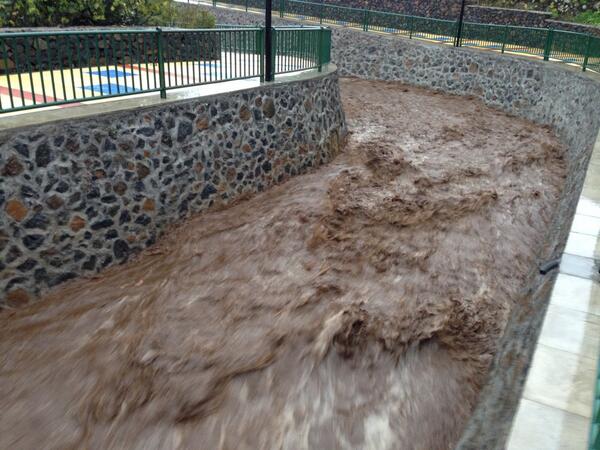
Verklaart ook de grafieken.

[edit]
twitter:PrensaTenerife twitterde op maandag 02-12-2013 om 14:46:59 Cortado el carril de la TF-1 de acceso a Punta Prieta (Güímar) y el enlace completo por #LluviasTenerife. Precaución http://t.co/6wbQxAL8Du reageer retweet
 Cortado el carril de la TF-1 de acceso a Punta Prieta (Güímar) y el enlace completo por
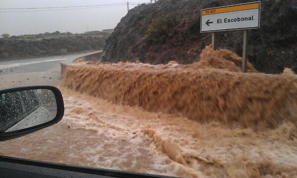
[edit]
twitter:teideano twitterde op maandag 02-12-2013 om 16:57:14 Absolutely amazing rainfall at Tenerife http://t.co/CFIUPdfk1v" reageer retweet
[ Bericht 7% gewijzigd door bwt op 02-12-2013 16:59:22 ]
<a href="http://goo.gl/q8fhTe" target="_blank">FAQ?</a>
<a href="http://goo.gl/gYvZFq" target="_blank">Geel is een zonnige en vrolijke kleur, als hij tenminste enigszins warm is gekleurd en wat naar het oranje neigt</a>
<a href="http://goo.gl/gYvZFq" target="_blank">Geel is een zonnige en vrolijke kleur, als hij tenminste enigszins warm is gekleurd en wat naar het oranje neigt</a>
Laatste foto vorige post:
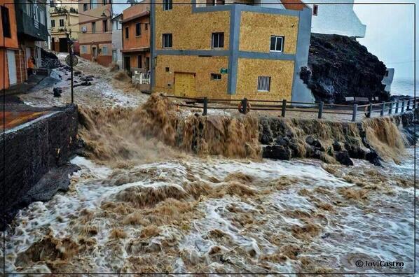
Sinds 9 uur 's ochtends aan het regenen geweest - op plaatsen tot 200 mm gevallen in 1 dag.
Het is gister kennelijk erg slecht geweest op de canarische eilanden en met name tenerife.twitter:teideano twitterde op maandag 02-12-2013 om 23:36:39 @Missy_Page Tenerife island, about 20 miles from Santa Cruz. reageer retweet
Sinds 9 uur 's ochtends aan het regenen geweest - op plaatsen tot 200 mm gevallen in 1 dag.
twitter:teideano twitterde op maandag 02-12-2013 om 17:24:08 Things are getting worse and worse. Pic: Vicente Bosch. http://t.co/NAqhR3OzFX reageer retweet

twitter:teideano twitterde op maandag 02-12-2013 om 20:03:27 No rain right now, but some models predict a long night here at Tenerife. More than 200mm so far at some spots. http://t.co/vhi1g8CHgR reageer retweet


<a href="http://goo.gl/q8fhTe" target="_blank">FAQ?</a>
<a href="http://goo.gl/gYvZFq" target="_blank">Geel is een zonnige en vrolijke kleur, als hij tenminste enigszins warm is gekleurd en wat naar het oranje neigt</a>
<a href="http://goo.gl/gYvZFq" target="_blank">Geel is een zonnige en vrolijke kleur, als hij tenminste enigszins warm is gekleurd en wat naar het oranje neigt</a>
Nog wat video beelden van het tenerife noodweer

twitter:AlertaMeteo twitterde op vrijdag 06-12-2013 om 20:18:06 Impresionante esta imágen que nos llega desde #Tenerife - #España. Potentes lluvias que ponen en #alerta a la isla. http://t.co/Lb4RXcBw5C reageer retweet
 Impresionante esta imágen que nos llega desde
twitter:teideano twitterde op zaterdag 07-12-2013 om 09:33:56 Another #amazing pic from yesterday #storm at #tenerife. #meteo #weather. Author is Luisma de León. http://t.co/xRwOR7iusR reageer retweet

<a href="http://goo.gl/q8fhTe" target="_blank">FAQ?</a>
<a href="http://goo.gl/gYvZFq" target="_blank">Geel is een zonnige en vrolijke kleur, als hij tenminste enigszins warm is gekleurd en wat naar het oranje neigt</a>
<a href="http://goo.gl/gYvZFq" target="_blank">Geel is een zonnige en vrolijke kleur, als hij tenminste enigszins warm is gekleurd en wat naar het oranje neigt</a>
El-Hierro wise is er niet veel gaande
quote:1249092 08/12/2013 02:23:04 27.7204 -18.0329 12 2.0 mbLg SW FRONTERA.IHI [+]
1249003 07/12/2013 08:12:47 27.7206 -18.0323 11 1.7 mbLg SW FRONTERA.IHI [+]
1248956 06/12/2013 23:18:45 27.6801 -17.9915 20 1.8 mbLg SW EL PINAR.IHI [+]
1248951 06/12/2013 23:00:43 27.7225 -18.0297 12 1.5 mbLg SW FRONTERA.IHI [+]
1248894 06/12/2013 05:33:03 27.7225 -18.0250 12 1.7 mbLg SW FRONTERA.IHI [+]
1248889 06/12/2013 05:09:11 27.7115 -18.0353 13 1.7 mbLg W EL PINAR.IHI [+]
1248547 04/12/2013 04:02:28 27.7486 -18.2499 11 2.2 mbLg W FRONTERA.IHI [+]
1248519 03/12/2013 13:31:50 27.7179 -18.0041 16 1.7 mbLg NW EL PINAR.IHI [+]
1248274 01/12/2013 22:00:20 27.7226 -18.0187 12 II 2.3 mbLg SW FRONTERA.IHI [+]
1248271 01/12/2013 21:10:51 27.7689 -18.0325 23 1.6 mbLg NW FRONTERA.IHI [+]
1248162 30/11/2013 23:04:20 27.7255 -18.0129 10 1.7 mbLg SW FRONTERA.IHI [+]
1248123 30/11/2013 15:47:26 27.7228 -18.0294 12 1.5 mbLg SW FRONTERA.IHI [+]
<a href="http://goo.gl/q8fhTe" target="_blank">FAQ?</a>
<a href="http://goo.gl/gYvZFq" target="_blank">Geel is een zonnige en vrolijke kleur, als hij tenminste enigszins warm is gekleurd en wat naar het oranje neigt</a>
<a href="http://goo.gl/gYvZFq" target="_blank">Geel is een zonnige en vrolijke kleur, als hij tenminste enigszins warm is gekleurd en wat naar het oranje neigt</a>
Inderdaad rustig:
Afgelopen 36 uur:
Afgelopen 15 dagen (wel iets drukker)
Afgelopen 36 uur:

Afgelopen 15 dagen (wel iets drukker)

<a href="http://goo.gl/q8fhTe" target="_blank">FAQ?</a>
<a href="http://goo.gl/gYvZFq" target="_blank">Geel is een zonnige en vrolijke kleur, als hij tenminste enigszins warm is gekleurd en wat naar het oranje neigt</a>
<a href="http://goo.gl/gYvZFq" target="_blank">Geel is een zonnige en vrolijke kleur, als hij tenminste enigszins warm is gekleurd en wat naar het oranje neigt</a>
Het houd nog niet op - het slechte weer op de canarische eilanden
En het zelfde plaatje bij deze twitter post
[edit]
laatste berichtjes naar nieuwe post gezet - zijn van vandaag!!!!
[ Bericht 23% gewijzigd door bwt op 11-12-2013 12:21:38 ]
twitter:teideano twitterde op dinsdag 10-12-2013 om 12:50:53 #meteo #weather Tenerife and La Palma both to expect for torrential rain, up to 60mm in 1 hour. http://t.co/VZoIDvKBL5 reageer retweet

En het zelfde plaatje bij deze twitter post
En ook duidelijk slecht weer op El Hierrotwitter:canariesnews twitterde op dinsdag 10-12-2013 om 19:08:57 New post! La Palma on 'Red Alert' for rain and bad weather - http://t.co/lYAb7LRSjI http://t.co/J2nOIotfvP reageer retweet
 New post! La Palma on 'Red Alert' for rain and bad weather -
 twitter:teideano twitterde op dinsdag 10-12-2013 om 14:11:23 Muelle de La Estaca,El Hierro a las 12.30 #alertacanarias #meteo #weather Foto vía cazatormentas, Arselumaco. http://t.co/LPx71maCuS reageer retweet

[edit]
laatste berichtjes naar nieuwe post gezet - zijn van vandaag!!!!
[ Bericht 23% gewijzigd door bwt op 11-12-2013 12:21:38 ]
<a href="http://goo.gl/q8fhTe" target="_blank">FAQ?</a>
<a href="http://goo.gl/gYvZFq" target="_blank">Geel is een zonnige en vrolijke kleur, als hij tenminste enigszins warm is gekleurd en wat naar het oranje neigt</a>
<a href="http://goo.gl/gYvZFq" target="_blank">Geel is een zonnige en vrolijke kleur, als hij tenminste enigszins warm is gekleurd en wat naar het oranje neigt</a>
En de eerste plaatjes van de storm die over de canarische eilanden raast.
Nog geen week na de vorige storm.
Nog geen week na de vorige storm.
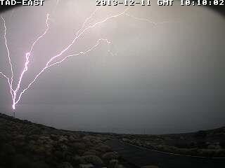
twitter:InfoMeteoTuit twitterde op woensdag 11-12-2013 om 11:01:50 Espectacular rayo cazado al norte de #Tenerife foto Viecente R. Boch vía @MeteoRTVC #Canarias #FMACanarias #Tormenta http://t.co/j3PNs3hDMx reageer retweet
 Espectacular rayo cazado al norte de
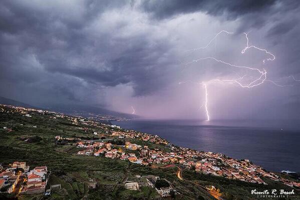
twitter:teideano twitterde op woensdag 11-12-2013 om 11:42:19 Amazing #storm over Tenerife right now. #meteo #weather #nature via @sergiovelascom: Rayo en Observatorio del Teide http://t.co/I1E75QVB8k" reageer retweet
twitter:teideano twitterde op woensdag 11-12-2013 om 11:58:24 Another pic from the storm. #meteo #weather #nature by Carlos Hernandez. http://t.co/11EgQRsq0H reageer retweet

<a href="http://goo.gl/q8fhTe" target="_blank">FAQ?</a>
<a href="http://goo.gl/gYvZFq" target="_blank">Geel is een zonnige en vrolijke kleur, als hij tenminste enigszins warm is gekleurd en wat naar het oranje neigt</a>
<a href="http://goo.gl/gYvZFq" target="_blank">Geel is een zonnige en vrolijke kleur, als hij tenminste enigszins warm is gekleurd en wat naar het oranje neigt</a>
Bezig uurtje.
Zwakke bevingen maar wel duidelijk zichtbaar.
1249759 12/12/2013 05:54:08 27.7096 -18.0273 10 1.5 mbLg W EL PINAR.IHI [+]
1249758 12/12/2013 05:50:11 27.7124 -18.0297 10 1.8 mbLg W EL PINAR.IHI [+]
1249757 12/12/2013 05:22:05 27.7135 -18.0323 11 1.5 mbLg W EL PINAR.IHI [+]
1249756 12/12/2013 05:16:44 27.7172 -18.0308 9 2.1 mbLg W EL PINAR.IHI [+]
1249755 12/12/2013 05:16:32 27.7182 -18.0300 11 2.3 mbLg W EL PINAR.IHI [+]
[ Bericht 13% gewijzigd door bwt op 12-12-2013 13:28:47 ]
Zwakke bevingen maar wel duidelijk zichtbaar.

1249759 12/12/2013 05:54:08 27.7096 -18.0273 10 1.5 mbLg W EL PINAR.IHI [+]
1249758 12/12/2013 05:50:11 27.7124 -18.0297 10 1.8 mbLg W EL PINAR.IHI [+]
1249757 12/12/2013 05:22:05 27.7135 -18.0323 11 1.5 mbLg W EL PINAR.IHI [+]
1249756 12/12/2013 05:16:44 27.7172 -18.0308 9 2.1 mbLg W EL PINAR.IHI [+]
1249755 12/12/2013 05:16:32 27.7182 -18.0300 11 2.3 mbLg W EL PINAR.IHI [+]

[ Bericht 13% gewijzigd door bwt op 12-12-2013 13:28:47 ]
<a href="http://goo.gl/q8fhTe" target="_blank">FAQ?</a>
<a href="http://goo.gl/gYvZFq" target="_blank">Geel is een zonnige en vrolijke kleur, als hij tenminste enigszins warm is gekleurd en wat naar het oranje neigt</a>
<a href="http://goo.gl/gYvZFq" target="_blank">Geel is een zonnige en vrolijke kleur, als hij tenminste enigszins warm is gekleurd en wat naar het oranje neigt</a>
Apparatuur voor de grafieken lijkt een beetje kapot
Metingen staan allemaal op 0.
Mogelijk door het slechte weer van de afgelopen tijd.
Wilt echter niet zeggen dat er niets geregistreerd wordt op andere manieren.
[ Bericht 17% gewijzigd door bwt op 16-12-2013 13:16:48 ]
Metingen staan allemaal op 0.
Mogelijk door het slechte weer van de afgelopen tijd.

Wilt echter niet zeggen dat er niets geregistreerd wordt op andere manieren.
De 2.6 is ook gevoeld op het eilandquote:1250093 14/12/2013 21:42:09 27.7255 -18.0179 13 2.6 mbLg SW FRONTERA.IHI [+]
1250094 14/12/2013 21:40:51 27.7224 -18.0127 12 2.2 mbLg NW EL PINAR.IHI [+]
1250068 14/12/2013 12:59:54 27.7295 -18.0106 9 1.6 mbLg SW FRONTERA.IHI [+]
[ Bericht 17% gewijzigd door bwt op 16-12-2013 13:16:48 ]
<a href="http://goo.gl/q8fhTe" target="_blank">FAQ?</a>
<a href="http://goo.gl/gYvZFq" target="_blank">Geel is een zonnige en vrolijke kleur, als hij tenminste enigszins warm is gekleurd en wat naar het oranje neigt</a>
<a href="http://goo.gl/gYvZFq" target="_blank">Geel is een zonnige en vrolijke kleur, als hij tenminste enigszins warm is gekleurd en wat naar het oranje neigt</a>
Inmidels weer 3 dagen bevingloos
Het 15 daagse overzicht

Het 15 daagse overzicht

<a href="http://goo.gl/q8fhTe" target="_blank">FAQ?</a>
<a href="http://goo.gl/gYvZFq" target="_blank">Geel is een zonnige en vrolijke kleur, als hij tenminste enigszins warm is gekleurd en wat naar het oranje neigt</a>
<a href="http://goo.gl/gYvZFq" target="_blank">Geel is een zonnige en vrolijke kleur, als hij tenminste enigszins warm is gekleurd en wat naar het oranje neigt</a>
[/me]quote:2013-12-18 18:47 UTC
Readers Berry and Leona have told us earlier today that the CHIE graph is alive again. The sensor has however been replaced by the CTIG seismograph.
Only 2 earthquakes since our last update on December 14!
<a href="http://goo.gl/q8fhTe" target="_blank">FAQ?</a>
<a href="http://goo.gl/gYvZFq" target="_blank">Geel is een zonnige en vrolijke kleur, als hij tenminste enigszins warm is gekleurd en wat naar het oranje neigt</a>
<a href="http://goo.gl/gYvZFq" target="_blank">Geel is een zonnige en vrolijke kleur, als hij tenminste enigszins warm is gekleurd en wat naar het oranje neigt</a>
quote:2013-12-21 09:37 UTC
Activity below the island has almost arrived at a standstill as we had only very few earthquakes the last week.
- We have just archived Part 59 of the El Hierro story (we still believe that a new activity period can appear the following days, weeks, months …). Link at the bottom of this page.

<a href="http://goo.gl/q8fhTe" target="_blank">FAQ?</a>
<a href="http://goo.gl/gYvZFq" target="_blank">Geel is een zonnige en vrolijke kleur, als hij tenminste enigszins warm is gekleurd en wat naar het oranje neigt</a>
<a href="http://goo.gl/gYvZFq" target="_blank">Geel is een zonnige en vrolijke kleur, als hij tenminste enigszins warm is gekleurd en wat naar het oranje neigt</a>
Was het gister nog alsof er helemaal niets gebeurde. Vandaag het tegenovergestelde.
Wat er gaande is is nog geheel onbekend
Wel dat er een paar stevige klappers bij zaten.
1251201 22/12/2013 12:16:45 27.7060 -17.9779 16 Sentido 3.2 mbLg S EL PINAR.IHI [+]
En het bevings overzicht
1251217 22/12/2013 16:17:24 27.7370 -17.9525 12 1.9 mbLg NE EL PINAR.IHI [+]
1251216 22/12/2013 16:14:33 27.7224 -17.9645 2.2 mbLg NE EL PINAR.IHI [+]
1251215 22/12/2013 16:05:03 27.7064 -17.9933 17 2.4 mbLg W EL PINAR.IHI [+]
1251214 22/12/2013 15:46:51 27.7114 -17.9841 17 2.5 mbLg NW EL PINAR.IHI [+]
1251213 22/12/2013 15:39:53 27.7213 -17.9759 14 2.1 mbLg N EL PINAR.IHI [+]
1251212 22/12/2013 15:24:38 27.7003 -17.9728 15 2.7 mbLg SE EL PINAR.IHI [+]
1251211 22/12/2013 15:12:14 27.7107 -17.9807 17 2.6 mbLg NW EL PINAR.IHI [+]
1251210 22/12/2013 14:57:56 27.7220 -17.9768 16 2.4 mbLg N EL PINAR.IHI [+]
1251209 22/12/2013 14:42:38 27.7161 -17.9591 2.1 mbLg NE EL PINAR.IHI [+]
1251207 22/12/2013 14:30:23 27.7017 -17.9891 19 2.7 mbLg SW EL PINAR.IHI [+]
1251202 22/12/2013 13:00:29 27.7130 -17.9713 15 2.3 mbLg NE EL PINAR.IHI [+]
1251201 22/12/2013 12:16:45 27.7060 -17.9779 16 Sentido 3.2 mbLg S EL PINAR.IHI [+]
1251197 22/12/2013 10:51:02 27.7056 -17.9880 17 2.8 mbLg W EL PINAR.IHI [+]
1251183 22/12/2013 08:27:40 27.7200 -17.9887 16 1.9 mbLg NW EL PINAR.IHI [+]
1251182 22/12/2013 07:36:55 27.7483 -17.9916 17 2.2 mbLg SE FRONTERA.IHI [+]
1251161 22/12/2013 05:41:45 27.7729 -18.0179 17 1.6 mbLg NW FRONTERA.IHI [+]
1251159 22/12/2013 04:27:07 27.7762 -18.0156 16 1.5 mbLg NW FRONTERA.IHI [+]
1251158 22/12/2013 04:08:02 27.7827 -18.0249 14 2.1 mbLg NW FRONTERA.IHI [+]
1251157 22/12/2013 04:01:05 27.7580 -18.0322 16 2.4 mbLg W FRONTERA.IHI [+]
1251156 22/12/2013 03:18:49 27.6514 -17.9980 16 1.7 mbLg SW EL PINAR.IHI [+]
1251155 22/12/2013 03:16:48 27.7525 -18.0334 15 2.0 mbLg W FRONTERA.IHI [+]
1251135 22/12/2013 02:32:11 27.7954 -18.0464 15 1.5 mbLg NW FRONTERA.IHI [+]
1251133 22/12/2013 01:55:38 27.8217 -18.0448 13 1.8 mbLg NW FRONTERA.IHI [+]
1251132 22/12/2013 01:43:52 27.8079 -18.0529 16 1.6 mbLg NW FRONTERA.IHI [+]
1251131 22/12/2013 01:42:54 27.7964 -18.0458 16 1.8 mbLg NW FRONTERA.IHI [+]
1251129 22/12/2013 01:42:24 27.8139 -18.0501 15 2.1 mbLg NW FRONTERA.IHI [+]
[ Bericht 3% gewijzigd door bwt op 22-12-2013 18:10:43 ]
Wat er gaande is is nog geheel onbekend
Wel dat er een paar stevige klappers bij zaten.
1251201 22/12/2013 12:16:45 27.7060 -17.9779 16 Sentido 3.2 mbLg S EL PINAR.IHI [+]
quote:2013-12-22 09:21 UTC
A sudden increase of seismicity. Too soon to talk about a new crisis, but with 5 2+ Magnitude earthquakes on 13 quakes, this looks to be more than the usual small -M1 quakes we have seen the recent weeks. (Thank You Leona for alerting us).
Stronger earthquakes are within reach today.
Most epicenters are located in the El Golfo area and some of them may even have been felt by people living in Frontera.
The depth is normal for all beginning activity. As long as the hypocenters (breaking point generating the earthquakes) is not below 10 km, looking for an eruptive episode is not realistic.
Shaking from earthquakes is starting to be dangerous from M3 on for landslides (steep cliffs area) and from M4 on for structures (mainly cracks in walls and NOT collapsed houses).
2013-12-22 10:22 UTC
The seismograph screenshot from La Restinga shows the current activity. Apart from the listed earthquakes, we also see a lot of micro-seismicity (mainly by comparing the graphs from the past days). Please note that most of the oscillations are coming from human triggered events (seismographs are very sensitive). The thicker tremor line started however when seismicity increased.
2013-12-22 15:20 UTC
As said in our prior updates a magma intrusion is currently going on below El Hierro. So far the strongest earthquake is a M3.2 at 12:16. Stronger earthquakes may be expected. The depth remains at a safe level.


twitter:teideano twitterde op zondag 22-12-2013 om 16:39:13 Seismicity at El Hierro is back again, up to 3,2M 20 quakes so far today. #nature #volcano #geology http://t.co/9QQUE3a1Vs maps available reageer retweet
twitter:teideano twitterde op zondag 22-12-2013 om 17:01:06 Ultimo terremoto localizado en El Hierro a travès de la #app Avcan Quake http://t.co/1TOiyC3pmE reageer retweet
twitter:teideano twitterde op zondag 22-12-2013 om 17:03:31 Otro terremoto más localizado en El Hierro M2.7 con la #app Avcan Quake. Día de actividad importante. http://t.co/ef6p99kjLX reageer retweet
twitter:teideano twitterde op zondag 22-12-2013 om 17:36:54 Otros 4 terremotos más en El Hierro. imagen del ùltimo de ellos, de M2,2 a travès de la #app Avcan Quake. http://t.co/ogSnrRj7Qf reageer retweet

En het bevings overzicht
1251217 22/12/2013 16:17:24 27.7370 -17.9525 12 1.9 mbLg NE EL PINAR.IHI [+]
1251216 22/12/2013 16:14:33 27.7224 -17.9645 2.2 mbLg NE EL PINAR.IHI [+]
1251215 22/12/2013 16:05:03 27.7064 -17.9933 17 2.4 mbLg W EL PINAR.IHI [+]
1251214 22/12/2013 15:46:51 27.7114 -17.9841 17 2.5 mbLg NW EL PINAR.IHI [+]
1251213 22/12/2013 15:39:53 27.7213 -17.9759 14 2.1 mbLg N EL PINAR.IHI [+]
1251212 22/12/2013 15:24:38 27.7003 -17.9728 15 2.7 mbLg SE EL PINAR.IHI [+]
1251211 22/12/2013 15:12:14 27.7107 -17.9807 17 2.6 mbLg NW EL PINAR.IHI [+]
1251210 22/12/2013 14:57:56 27.7220 -17.9768 16 2.4 mbLg N EL PINAR.IHI [+]
1251209 22/12/2013 14:42:38 27.7161 -17.9591 2.1 mbLg NE EL PINAR.IHI [+]
1251207 22/12/2013 14:30:23 27.7017 -17.9891 19 2.7 mbLg SW EL PINAR.IHI [+]
1251202 22/12/2013 13:00:29 27.7130 -17.9713 15 2.3 mbLg NE EL PINAR.IHI [+]
1251201 22/12/2013 12:16:45 27.7060 -17.9779 16 Sentido 3.2 mbLg S EL PINAR.IHI [+]
1251197 22/12/2013 10:51:02 27.7056 -17.9880 17 2.8 mbLg W EL PINAR.IHI [+]
1251183 22/12/2013 08:27:40 27.7200 -17.9887 16 1.9 mbLg NW EL PINAR.IHI [+]
1251182 22/12/2013 07:36:55 27.7483 -17.9916 17 2.2 mbLg SE FRONTERA.IHI [+]
1251161 22/12/2013 05:41:45 27.7729 -18.0179 17 1.6 mbLg NW FRONTERA.IHI [+]
1251159 22/12/2013 04:27:07 27.7762 -18.0156 16 1.5 mbLg NW FRONTERA.IHI [+]
1251158 22/12/2013 04:08:02 27.7827 -18.0249 14 2.1 mbLg NW FRONTERA.IHI [+]
1251157 22/12/2013 04:01:05 27.7580 -18.0322 16 2.4 mbLg W FRONTERA.IHI [+]
1251156 22/12/2013 03:18:49 27.6514 -17.9980 16 1.7 mbLg SW EL PINAR.IHI [+]
1251155 22/12/2013 03:16:48 27.7525 -18.0334 15 2.0 mbLg W FRONTERA.IHI [+]
1251135 22/12/2013 02:32:11 27.7954 -18.0464 15 1.5 mbLg NW FRONTERA.IHI [+]
1251133 22/12/2013 01:55:38 27.8217 -18.0448 13 1.8 mbLg NW FRONTERA.IHI [+]
1251132 22/12/2013 01:43:52 27.8079 -18.0529 16 1.6 mbLg NW FRONTERA.IHI [+]
1251131 22/12/2013 01:42:54 27.7964 -18.0458 16 1.8 mbLg NW FRONTERA.IHI [+]
1251129 22/12/2013 01:42:24 27.8139 -18.0501 15 2.1 mbLg NW FRONTERA.IHI [+]
[ Bericht 3% gewijzigd door bwt op 22-12-2013 18:10:43 ]
<a href="http://goo.gl/q8fhTe" target="_blank">FAQ?</a>
<a href="http://goo.gl/gYvZFq" target="_blank">Geel is een zonnige en vrolijke kleur, als hij tenminste enigszins warm is gekleurd en wat naar het oranje neigt</a>
<a href="http://goo.gl/gYvZFq" target="_blank">Geel is een zonnige en vrolijke kleur, als hij tenminste enigszins warm is gekleurd en wat naar het oranje neigt</a>
Het is nog te vroeg om iets zinnigs te roepen over wat er gaande is.
Er is geen indicatie dat het eiland weer aan het groeien / verplaatsen is zoals bij de vorige activiteiten
Zag het er gister nog zo uit:
Vandaag is het duidelijk drukker
En waar waren de bevingen dan?
Afgelopen 36 uur:
En de afgelopen 15 dagen
En hoe druk was het tussen 16-17 uur
1251219 22/12/2013 16:34:32 27.7324 -17.9685 15 2.7 mbLg NE EL PINAR.IHI [+]
1251218 22/12/2013 16:31:51 27.7129 -17.9932 18 Sentido 3.1 mbLg NW EL PINAR.IHI [+]
De onderste is omhoog geschaald van 3.0 naar 3.1
Mogelijk gaat de bovenste van de 3 ook nog omhoog.
[edit]
Yep, van 3.1 naar 3.2
Activiteit lijkt af te nemen
[ Bericht 8% gewijzigd door bwt op 22-12-2013 18:29:30 ]
Er is geen indicatie dat het eiland weer aan het groeien / verplaatsen is zoals bij de vorige activiteiten
Zag het er gister nog zo uit:

Vandaag is het duidelijk drukker

En waar waren de bevingen dan?
Afgelopen 36 uur:

En de afgelopen 15 dagen

En hoe druk was het tussen 16-17 uur

1251220 22/12/2013 16:34:52 27.7220 -17.9726 17 Sentido 3.2 mbLg NE EL PINAR.IHI [+]twitter:
1251219 22/12/2013 16:34:32 27.7324 -17.9685 15 2.7 mbLg NE EL PINAR.IHI [+]
1251218 22/12/2013 16:31:51 27.7129 -17.9932 18 Sentido 3.1 mbLg NW EL PINAR.IHI [+]
De onderste is omhoog geschaald van 3.0 naar 3.1
Mogelijk gaat de bovenste van de 3 ook nog omhoog.
[edit]
Yep, van 3.1 naar 3.2
Activiteit lijkt af te nemen

[ Bericht 8% gewijzigd door bwt op 22-12-2013 18:29:30 ]
<a href="http://goo.gl/q8fhTe" target="_blank">FAQ?</a>
<a href="http://goo.gl/gYvZFq" target="_blank">Geel is een zonnige en vrolijke kleur, als hij tenminste enigszins warm is gekleurd en wat naar het oranje neigt</a>
<a href="http://goo.gl/gYvZFq" target="_blank">Geel is een zonnige en vrolijke kleur, als hij tenminste enigszins warm is gekleurd en wat naar het oranje neigt</a>
Hahahaha,quote:
Hier dan een mooie van meteo consult / weer.nl
twitter:MeteoConsult twitterde op zaterdag 21-12-2013 om 07:34:31 Een kerstboom gesignaleerd in de neerslagpluim voor eerste kerstdag..... Oei.. dat wordt veel regen. http://t.co/zjIx5PIPmS reageer retweet
 Een kerstboom gesignaleerd in de neerslagpluim voor eerste kerstdag..... Oei.. dat wordt veel regen.
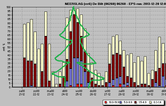
<a href="http://goo.gl/q8fhTe" target="_blank">FAQ?</a>
<a href="http://goo.gl/gYvZFq" target="_blank">Geel is een zonnige en vrolijke kleur, als hij tenminste enigszins warm is gekleurd en wat naar het oranje neigt</a>
<a href="http://goo.gl/gYvZFq" target="_blank">Geel is een zonnige en vrolijke kleur, als hij tenminste enigszins warm is gekleurd en wat naar het oranje neigt</a>
Het is wel wat afgezwakt inmiddels.
1251287 22/12/2013 23:58:49 27.7125 -17.9795 1.8 mbLg NW EL PINAR.IHI [+]
1251286 22/12/2013 23:55:35 27.7129 -17.9688 1.9 mbLg NE EL PINAR.IHI [+]
1251285 22/12/2013 23:43:55 27.7120 -17.9750 16 2.1 mbLg NE EL PINAR.IHI [+]
1251284 22/12/2013 23:36:48 27.7061 -17.9767 18 2.4 mbLg SE EL PINAR.IHI [+]
1251282 22/12/2013 23:30:45 27.7062 -17.9788 16 2.9 mbLg SW EL PINAR.IHI [+]
1251281 22/12/2013 23:29:32 27.7079 -17.9920 18 2.7 mbLg W EL PINAR.IHI [+]
1251279 22/12/2013 23:13:14 27.7246 -17.9774 15 2.2 mbLg N EL PINAR.IHI [+]
1251278 22/12/2013 23:05:22 27.7175 -17.9742 18 2.3 mbLg NE EL PINAR.IHI [+]
1251277 22/12/2013 23:01:31 27.7352 -17.9747 20 1.8 mbLg N EL PINAR.IHI [+]
1251276 22/12/2013 22:54:50 27.7111 -17.9873 15 1.6 mbLg NW EL PINAR.IHI [+]
1251274 22/12/2013 22:51:34 27.7178 -17.9907 16 2.1 mbLg NW EL PINAR.IHI [+]
1251273 22/12/2013 22:44:08 27.7134 -17.9670 2.6 mbLg NE EL PINAR.IHI [+]
1251272 22/12/2013 22:35:17 27.6785 -18.0140 31 2.3 mbLg SW EL PINAR.IHI [+]
1251271 22/12/2013 22:30:17 27.7034 -17.9846 16 2.7 mbLg SW EL PINAR.IHI [+]
1251270 22/12/2013 22:26:07 27.7060 -17.9851 2.4 mbLg SW EL PINAR.IHI [+]
1251269 22/12/2013 22:25:38 27.7030 -17.9888 17 2.5 mbLg SW EL PINAR.IHI [+]
1251265 22/12/2013 22:17:15 27.7081 -17.9806 1.7 mbLg W EL PINAR.IHI [+]
1251263 22/12/2013 22:08:09 27.7089 -17.9791 15 2.2 mbLg NW EL PINAR.IHI [+]
1251262 22/12/2013 22:03:38 27.7062 -17.9855 17 2.3 mbLg SW EL PINAR.IHI [+]
1251261 22/12/2013 21:54:57 27.7163 -17.9764 17 2.1 mbLg NE EL PINAR.IHI [+]
1251260 22/12/2013 21:54:22 27.7285 -17.9842 16 2.0 mbLg NW EL PINAR.IHI [+]
1251245 22/12/2013 19:11:34 27.7170 -17.9579 16 1.6 mbLg NE EL PINAR.IHI [+]
1251246 22/12/2013 18:56:49 27.7198 -17.9581 16 1.8 mbLg NE EL PINAR.IHI [+]
1251243 22/12/2013 18:53:47 27.7022 -17.9703 17 1.5 mbLg SE EL PINAR.IHI [+]
1251241 22/12/2013 18:50:30 27.7272 -17.9563 17 1.5 mbLg NE EL PINAR.IHI [+]
1251240 22/12/2013 18:47:34 27.7268 -17.9524 16 1.6 mbLg NE EL PINAR.IHI [+]
1251236 22/12/2013 18:25:13 27.7267 -17.9624 17 1.8 mbLg NE EL PINAR.IHI [+]
1251234 22/12/2013 18:22:31 27.7162 -17.9528 15 2.0 mbLg NE EL PINAR.IHI [+]
1251234 22/12/2013 18:22:31 27.7162 -17.9528 15 2.0 mbLg NE EL PINAR.IHI [+]
1251233 22/12/2013 18:19:22 27.7302 -17.9769 21 2.0 mbLg N EL PINAR.IHI [+]
1251230 22/12/2013 17:55:03 27.7232 -17.9806 15 2.4 mbLg N EL PINAR.IHI [+]
1251232 22/12/2013 17:39:41 27.7254 -17.9736 17 2.0 mbLg N EL PINAR.IHI [+]
1251229 22/12/2013 17:11:25 27.7185 -17.9605 16 1.5 mbLg NE EL PINAR.IHI [+]
1251225 22/12/2013 17:07:43 27.7279 -17.9818 16 2.0 mbLg N EL PINAR.IHI [+]
1251227 22/12/2013 17:04:14 27.7273 -17.9580 15 1.7 mbLg NE EL PINAR.IHI [+]
1251228 22/12/2013 16:56:58 27.7236 -17.9636 14 1.5 mbLg NE EL PINAR.IHI [+]
[ Bericht 22% gewijzigd door bwt op 23-12-2013 10:04:19 ]
1251287 22/12/2013 23:58:49 27.7125 -17.9795 1.8 mbLg NW EL PINAR.IHI [+]
1251286 22/12/2013 23:55:35 27.7129 -17.9688 1.9 mbLg NE EL PINAR.IHI [+]
1251285 22/12/2013 23:43:55 27.7120 -17.9750 16 2.1 mbLg NE EL PINAR.IHI [+]
1251284 22/12/2013 23:36:48 27.7061 -17.9767 18 2.4 mbLg SE EL PINAR.IHI [+]
1251282 22/12/2013 23:30:45 27.7062 -17.9788 16 2.9 mbLg SW EL PINAR.IHI [+]
1251281 22/12/2013 23:29:32 27.7079 -17.9920 18 2.7 mbLg W EL PINAR.IHI [+]
1251279 22/12/2013 23:13:14 27.7246 -17.9774 15 2.2 mbLg N EL PINAR.IHI [+]
1251278 22/12/2013 23:05:22 27.7175 -17.9742 18 2.3 mbLg NE EL PINAR.IHI [+]
1251277 22/12/2013 23:01:31 27.7352 -17.9747 20 1.8 mbLg N EL PINAR.IHI [+]
1251276 22/12/2013 22:54:50 27.7111 -17.9873 15 1.6 mbLg NW EL PINAR.IHI [+]
1251274 22/12/2013 22:51:34 27.7178 -17.9907 16 2.1 mbLg NW EL PINAR.IHI [+]
1251273 22/12/2013 22:44:08 27.7134 -17.9670 2.6 mbLg NE EL PINAR.IHI [+]
1251272 22/12/2013 22:35:17 27.6785 -18.0140 31 2.3 mbLg SW EL PINAR.IHI [+]
1251271 22/12/2013 22:30:17 27.7034 -17.9846 16 2.7 mbLg SW EL PINAR.IHI [+]
1251270 22/12/2013 22:26:07 27.7060 -17.9851 2.4 mbLg SW EL PINAR.IHI [+]
1251269 22/12/2013 22:25:38 27.7030 -17.9888 17 2.5 mbLg SW EL PINAR.IHI [+]
1251265 22/12/2013 22:17:15 27.7081 -17.9806 1.7 mbLg W EL PINAR.IHI [+]
1251263 22/12/2013 22:08:09 27.7089 -17.9791 15 2.2 mbLg NW EL PINAR.IHI [+]
1251262 22/12/2013 22:03:38 27.7062 -17.9855 17 2.3 mbLg SW EL PINAR.IHI [+]
1251261 22/12/2013 21:54:57 27.7163 -17.9764 17 2.1 mbLg NE EL PINAR.IHI [+]
1251260 22/12/2013 21:54:22 27.7285 -17.9842 16 2.0 mbLg NW EL PINAR.IHI [+]
1251245 22/12/2013 19:11:34 27.7170 -17.9579 16 1.6 mbLg NE EL PINAR.IHI [+]
1251246 22/12/2013 18:56:49 27.7198 -17.9581 16 1.8 mbLg NE EL PINAR.IHI [+]
1251243 22/12/2013 18:53:47 27.7022 -17.9703 17 1.5 mbLg SE EL PINAR.IHI [+]
1251241 22/12/2013 18:50:30 27.7272 -17.9563 17 1.5 mbLg NE EL PINAR.IHI [+]
1251240 22/12/2013 18:47:34 27.7268 -17.9524 16 1.6 mbLg NE EL PINAR.IHI [+]
1251236 22/12/2013 18:25:13 27.7267 -17.9624 17 1.8 mbLg NE EL PINAR.IHI [+]
1251234 22/12/2013 18:22:31 27.7162 -17.9528 15 2.0 mbLg NE EL PINAR.IHI [+]
1251234 22/12/2013 18:22:31 27.7162 -17.9528 15 2.0 mbLg NE EL PINAR.IHI [+]
1251233 22/12/2013 18:19:22 27.7302 -17.9769 21 2.0 mbLg N EL PINAR.IHI [+]
1251230 22/12/2013 17:55:03 27.7232 -17.9806 15 2.4 mbLg N EL PINAR.IHI [+]
1251232 22/12/2013 17:39:41 27.7254 -17.9736 17 2.0 mbLg N EL PINAR.IHI [+]
1251229 22/12/2013 17:11:25 27.7185 -17.9605 16 1.5 mbLg NE EL PINAR.IHI [+]
1251225 22/12/2013 17:07:43 27.7279 -17.9818 16 2.0 mbLg N EL PINAR.IHI [+]
1251227 22/12/2013 17:04:14 27.7273 -17.9580 15 1.7 mbLg NE EL PINAR.IHI [+]
1251228 22/12/2013 16:56:58 27.7236 -17.9636 14 1.5 mbLg NE EL PINAR.IHI [+]
quote:2013-12-22 19:44 UTC
Our opinion written during the first update this morning became true, a new magma intrusion is occurring below the island. Some people are so excited about the new activity that they are spreading some kind of minor panic. We emphasise that IGN did a great job in following up all other crisis and that they are standby 24 hours a day. The location were they are watching the instruments (Madrid or El Hierro) is totally unimportant at this moment. The earthquakes are still in average in between 13 and 15 km with NO fast progression to a shallower depth. IGN will increase the number of instruments (some were apparently broken after the bad weather) and will certainly be replaced.
We will of course NOT comment on every earthquake BUT we are following up what happens and will report asap when something new and relevant is happening (as you now of course).
- The activity as it started this morning is intensifying. Nobody knows what wille happen the next minute, hour, day or week. It can suddenly stop or it can continue.If it continues we expect even stronger earthquakes than the ones so far, this based on earlier crisis. Good to repeat that only earthquakes (below first 10 km and later 5 km) will throw another light on the current situation.
- 41 earthquakes so far today IGN reports 4 felt by the islanders but we think there are more felt, but only 4 reported at IGN.
- The epicenters of the last 10 earthquakes are mainly at the eastern part of the island, a totally other section than the one earlier activity was noted. This brings a new uncertainty in the field as we do not know the resistance of this part (we know it from other parts).
- The intrusion has calmed down since a couple of hours (see the tremor line below getting thinner, but a new strong quake can change everything again pressure building up until it breaks). Do not hesitate to comment on the bottom of this page if the people following this activity are seeing something strange again. A 0 depth is (by the way) in 99.9% of the cases an instrument error).
- Something relaxing for our friends at the US and South-American East coast : We know that a lot of people are fearing a collapse of the island, but what is happening today occurs at the opposite end of the island.
[ Bericht 22% gewijzigd door bwt op 23-12-2013 10:04:19 ]
<a href="http://goo.gl/q8fhTe" target="_blank">FAQ?</a>
<a href="http://goo.gl/gYvZFq" target="_blank">Geel is een zonnige en vrolijke kleur, als hij tenminste enigszins warm is gekleurd en wat naar het oranje neigt</a>
<a href="http://goo.gl/gYvZFq" target="_blank">Geel is een zonnige en vrolijke kleur, als hij tenminste enigszins warm is gekleurd en wat naar het oranje neigt</a>
En het gaat vandaag weer verder
1251377 23/12/2013 07:50:09 27.7073 -17.9886 17 2.0 mbLg W EL PINAR.IHI [+]
1251366 23/12/2013 07:38:06 27.7071 -17.9843 16 2.2 mbLg W EL PINAR.IHI [+]
1251378 23/12/2013 07:32:05 27.7119 -17.9856 17 2.1 mbLg NW EL PINAR.IHI [+]
1251375 23/12/2013 07:25:35 27.7094 -17.9988 18 2.3 mbLg W EL PINAR.IHI [+]
1251355 23/12/2013 07:19:21 27.7076 -17.9945 16 2.4 mbLg W EL PINAR.IHI [+]
1251373 23/12/2013 07:15:06 27.7227 -17.9903 16 1.7 mbLg NW EL PINAR.IHI [+]
1251372 23/12/2013 07:00:40 27.7047 -17.9863 17 2.5 mbLg SW EL PINAR.IHI [+]
1251371 23/12/2013 06:59:18 27.7062 -17.9858 16 2.0 mbLg SW EL PINAR.IHI [+]
1251369 23/12/2013 06:57:10 27.7484 -18.0094 15 1.6 mbLg SW FRONTERA.IHI [+]
1251364 23/12/2013 06:40:38 27.7068 -17.9891 17 2.6 mbLg W EL PINAR.IHI [+]
1251363 23/12/2013 06:35:13 27.7204 -17.9824 16 2.6 mbLg NW EL PINAR.IHI [+]
1251362 23/12/2013 06:29:53 27.7136 -17.9760 15 2.2 mbLg NE EL PINAR.IHI [+]
1251361 23/12/2013 06:20:04 27.7077 -17.9750 14 2.1 mbLg E EL PINAR.IHI [+]
1251359 23/12/2013 06:18:49 27.7054 -17.9795 14 2.3 mbLg SW EL PINAR.IHI [+]
1251360 23/12/2013 06:10:00 27.7092 -17.9679 16 2.0 mbLg E EL PINAR.IHI [+]
1251353 23/12/2013 05:58:26 27.7062 -17.9823 16 2.0 mbLg SW EL PINAR.IHI [+]
1251352 23/12/2013 05:56:40 27.7061 -17.9842 17 1.9 mbLg SW EL PINAR.IHI [+]
1251351 23/12/2013 05:54:08 27.7183 -17.9845 14 1.7 mbLg NW EL PINAR.IHI [+]
1251349 23/12/2013 05:52:04 27.7129 -17.9689 15 1.8 mbLg NE EL PINAR.IHI [+]
1251348 23/12/2013 05:47:57 27.7283 -17.9892 16 1.9 mbLg NW EL PINAR.IHI [+]
1251347 23/12/2013 05:38:52 27.7041 -17.9859 16 2.1 mbLg SW EL PINAR.IHI [+]
1251320 23/12/2013 05:38:06 27.7046 -17.9815 16 2.7 mbLg SW EL PINAR.IHI [+]
1251346 23/12/2013 05:31:07 27.7087 -17.9843 15 2.2 mbLg W EL PINAR.IHI [+]
1251344 23/12/2013 05:15:36 27.7290 -17.9882 15 2.8 mbLg NW EL PINAR.IHI [+]
1251343 23/12/2013 05:08:47 27.7098 -17.9918 19 1.8 mbLg W EL PINAR.IHI [+]
1251319 23/12/2013 04:49:59 27.7103 -17.9802 15 2.6 mbLg NW EL PINAR.IHI [+]
1251318 23/12/2013 04:45:26 27.7126 -17.9965 19 2.2 mbLg W EL PINAR.IHI [+]
1251317 23/12/2013 04:37:59 27.7120 -17.9738 16 2.5 mbLg NE EL PINAR.IHI [+]
1251316 23/12/2013 04:24:26 27.7047 -17.9823 16 2.8 mbLg SW EL PINAR.IHI [+]
1251315 23/12/2013 04:13:59 27.7285 -18.0024 16 2.1 mbLg S FRONTERA.IHI [+]
1251308 23/12/2013 03:52:27 27.7214 -17.9878 18 2.1 mbLg NW EL PINAR.IHI [+]
1251307 23/12/2013 03:44:59 27.7128 -17.9902 18 2.2 mbLg NW EL PINAR.IHI [+]
1251306 23/12/2013 03:31:08 27.7067 -17.9917 17 2.5 mbLg W EL PINAR.IHI [+]
1251303 23/12/2013 03:13:30 27.7240 -17.9890 17 2.0 mbLg NW EL PINAR.IHI [+]
1251302 23/12/2013 02:57:10 27.7293 -17.9967 16 2.0 mbLg NW EL PINAR.IHI [+]
1251301 23/12/2013 02:13:50 27.7265 -17.9876 17 2.1 mbLg NW EL PINAR.IHI [+]
1251300 23/12/2013 01:53:38 27.7282 -17.9785 15 Sentido 2.7 mbLg N EL PINAR.IHI [+]
1251299 23/12/2013 01:36:28 27.7252 -17.9916 17 2.6 mbLg NW EL PINAR.IHI [+]
1251298 23/12/2013 01:27:39 27.7224 -17.9962 18 2.4 mbLg NW EL PINAR.IHI [+]
1251297 23/12/2013 01:23:56 27.7123 -17.9706 1.6 mbLg NE EL PINAR.IHI [+]
1251296 23/12/2013 01:16:23 27.7045 -17.9801 16 2.7 mbLg SW EL PINAR.IHI [+]
1251295 23/12/2013 01:07:42 27.7063 -17.9880 16 2.4 mbLg W EL PINAR.IHI [+]
1251294 23/12/2013 00:51:38 27.7027 -17.9795 18 2.0 mbLg SW EL PINAR.IHI [+]
1251293 23/12/2013 00:45:29 27.7038 -17.9816 16 2.2 mbLg SW EL PINAR.IHI [+]
1251291 23/12/2013 00:20:09 27.7145 -17.9774 1.8 mbLg N EL PINAR.IHI [+]
1251289 23/12/2013 00:15:30 27.7520 -18.0015 17 Sentido 3.1 mbLg SW FRONTERA.IHI [+]
1251292 23/12/2013 00:11:21 27.7047 -17.9867 17 2.5 mbLg SW EL PINAR.IHI [+]
1251290 23/12/2013 00:10:33 27.6981 -17.9928 20 2.2 mbLg SW EL PINAR.IHI [+]
1251288 23/12/2013 00:09:52 27.7077 -17.9853 17 2.6 mbLg W EL PINAR.IHI [+]
Het zit erg sterk op 1 plek

<a href="http://goo.gl/q8fhTe" target="_blank">FAQ?</a>
<a href="http://goo.gl/gYvZFq" target="_blank">Geel is een zonnige en vrolijke kleur, als hij tenminste enigszins warm is gekleurd en wat naar het oranje neigt</a>
<a href="http://goo.gl/gYvZFq" target="_blank">Geel is een zonnige en vrolijke kleur, als hij tenminste enigszins warm is gekleurd en wat naar het oranje neigt</a>
Bevingen blijven erg actief.
De tremor die er gister even te zien is geweest is inmiddels aal weer weg.
De bevingen van de afgelopen 36 uur
Volgens ER is eer ook weer een up-lift van verschillende delen van het eiland
[ Bericht 40% gewijzigd door bwt op 23-12-2013 20:16:03 ]
De tremor die er gister even te zien is geweest is inmiddels aal weer weg.
De bevingen van de afgelopen 36 uur

Volgens ER is eer ook weer een up-lift van verschillende delen van het eiland

quote:2013-12-23 08:49 UTC
- Confirmation of the current Magma thrust below the island comes from the deformation data from Involcan University of Nagoya (Prof. Sagiya) El Pinar GPS station. The thrust has led to an upwards deformation of at least 2 cm (Ultra Rapid data, to be confirmed later). De deformation to the North-East is less than a cm.
quote:2013-12-23 13:28 UTC
- Involcan (Nemesio Perez) and IGN (Carmen Lopez) are saying the same as we have done since the beginning yesterday
- 58 earthquakes listed by IGN so far today
- Location last earthquakes (El Pinar area) = unchanged
- Hypocenter depth : 15 to 18 km = unchanged
2013-12-23 09:32 UTC
- If you live in El Pinar, you do want to see the epicenter of the last set of earthquakes below. Almost all the current seismicity is concentrated in the direct El Pinar area (red squares). The initial earthquakes started in the El Golfo area (green squares are the older quakes). But, we repeat, at the current depth there is no immediate risk. If IGN would see any danger, they will act swiftly (we are convinced about that). As stronger earthquakes are expected we would advise people living in El Pinar to read our Be Earthquake Prepared section
quote:2013-12-23 18:02 UTC
- We just had contact with Joke Volta who lives in El Pinar, exactly the area with all the current epicenters. She said that she felt nothing important, just some light shaking now and then.
- If we look at the IGN deformation graphs (see below), 4 GPS stations are showing lifting deformations of around 2 cm HI08 is normal of course (the current epicenter area), but Hi09 (La Restinga part of the island), FRON (Frontera) and HI02 (El Golfo) who have almost the same upper deformation. All other stations on the island remain unchanged (please note that HI10, also on the lifting axe, has stopped reporting earlier this year).
- 99 earthquakes so far today !
[ Bericht 40% gewijzigd door bwt op 23-12-2013 20:16:03 ]
<a href="http://goo.gl/q8fhTe" target="_blank">FAQ?</a>
<a href="http://goo.gl/gYvZFq" target="_blank">Geel is een zonnige en vrolijke kleur, als hij tenminste enigszins warm is gekleurd en wat naar het oranje neigt</a>
<a href="http://goo.gl/gYvZFq" target="_blank">Geel is een zonnige en vrolijke kleur, als hij tenminste enigszins warm is gekleurd en wat naar het oranje neigt</a>
quote:El Hierro (Canary Islands, Spain): The new earthquake swarm that started under the island yesterday continues with now more than 100 quakes above magnitude 2 and several in the magnitude 3 range that were weakly felt on the island in some areas. The earthquakes are located at about 15 km depth under the southeastern central part of the island. Slight inflation is visible as well, suggesting that a new episode of magma inflation beneath the crust of the island has started. Whether or not this could lead to a new eruption is impossible to predict, but the most recent such episodes in the past 2 years occurred with no eruption following.
quote:2013-12-24 09:50 UTC
- Relatively few earthquakes today (less than yesterday)
- some information for both ends of readers. Those on the island who merely want to live their safe live and want to enjoy tourist spending : less earthquakes. Those (almost all from other places in the world : it is not over yet.
- The seismograph image below shows a strong earthquake at 06:17. If you are looking in the list for this earthquake, you will be surprised that it is only a 2.4 Magnitude. Why such a big line on the graph then? Because of the depth of 9 km. The seismograph is the confirmation that the depth must have been true (in seismology error margins are normal – in preliminary readings).
- Some activity is taking place offshore at the east of the island.
- Magma wint gradually into a more shallow layer. It went up approx. 2 km (from 15 to 17 km towards 12 to 15 km (last 5 earthquakes).
- The seismograph image shows at the end some more tremor indicating a further intrusion of magma. These quakes are not yet showed on the list.
- De El Pinar GPS deformation data is showing a Northern deformation of nearly 2 cm. More lifting of a bout 1 cm.
- The IGN deformation data are showing a further lifting of 2 cm! on the HI09 (La Restinga) GPS and a 1 cm lifting of the El Pinar HI08 GPS. this means lesser lifting in El Pinar and more lifting in La Restinga than the prior 24 hours. These readings are confirming what we see on the seismicity map.
- In terms of safety on the short term, we are convinced that a PEVOLCA will meet soon and will publish a report afterwards. (PEVOLCA safety board of the island consisting of IGN, INVOLCAN and the local and national authorities)

Activiteit lijkt wel sterk af te nemen.
Maar je weet het nooit
Deze beving valt op door de diepte van 9 KM
1251611 24/12/2013 06:17:26 27.6591 -17.9395 9 2.4 4 SE EL PINAR.IHI


En van een ander seismisch station op het eiland - ziet er een stuk zwakker uit.

[ Bericht 5% gewijzigd door bwt op 24-12-2013 11:58:45 ]
<a href="http://goo.gl/q8fhTe" target="_blank">FAQ?</a>
<a href="http://goo.gl/gYvZFq" target="_blank">Geel is een zonnige en vrolijke kleur, als hij tenminste enigszins warm is gekleurd en wat naar het oranje neigt</a>
<a href="http://goo.gl/gYvZFq" target="_blank">Geel is een zonnige en vrolijke kleur, als hij tenminste enigszins warm is gekleurd en wat naar het oranje neigt</a>
twitter:teideano twitterde op dinsdag 24-12-2013 om 10:06:56 200th quake at El Hierro in 48 hours. swarm still going on. #volcano #geology #science #nature http://t.co/lLCHbixxKm reageer retweet
twitter:teideano twitterde op dinsdag 24-12-2013 om 11:49:22 http://t.co/hpR68VLDjj Video showing the evolution of the current seismic swarm at El Hierro. #volcano #geology #science #nature reageer retweet

twitter:teideano twitterde op dinsdag 24-12-2013 om 11:28:03 Uplift detected in El Hierro. More than 2cm in 48 hours. New intrusion? #volcano #geology #science #nature http://t.co/lIzajTsKTx reageer retweet

<a href="http://goo.gl/q8fhTe" target="_blank">FAQ?</a>
<a href="http://goo.gl/gYvZFq" target="_blank">Geel is een zonnige en vrolijke kleur, als hij tenminste enigszins warm is gekleurd en wat naar het oranje neigt</a>
<a href="http://goo.gl/gYvZFq" target="_blank">Geel is een zonnige en vrolijke kleur, als hij tenminste enigszins warm is gekleurd en wat naar het oranje neigt</a>
Kracht en aantal van de bevingen neemt wat af. Lijkt het. Tremmors komen nog wel geregeld voor.
Bij Earthquake Report hebben ze een heel eigen redenatie die ook interessant is.
[ Bericht 6% gewijzigd door bwt op 25-12-2013 21:14:16 ]

Bij Earthquake Report hebben ze een heel eigen redenatie die ook interessant is.
De bijbehorende plaatjes laten een up-lift zien en een verplaatsing. Het noorderlijke deel naar het noorden en het zuidelijke deel richting zuiden.quote:2013-12-25 09:31 UTC
- Back to the pilot modus? No more listed earthquakes since 03:46 UTC, although we still see some activity and even some tremor on the La Restinga seismograph (we doubt that the IGN list is complete!).
- A very dispersed image of depths, ranging from 12 to 19 km (average 14 km) based on the latest listed earthquakes
- The weakening can however not be seen on the latest IGN deformation map where La Resinga HI09 (IGN) shows a lifting of another 2 cm (same than the prior 24 hours) and El Pinat also 2 cm up and a push to the North.. If this lifting will continue, this means that the accumulated energy will try to release itself with more earthquakes. Unfortunately, we only have GPS deformation data once a day.
- The University og Nagoya / Involcan GPS station is reporting an even stronger lifting to the North of the El Pinar GPS station. Both IGN and Uni of Nagoya are indication that the pressure is building further up below the island.
- Also important to mention is that the magma source below the island should be in between La Restinga and El Pinar. Why ? because the NS deformation charts of IGN is showing a thrust to the North in El Pinar and a thrust to the South in La Restinga.
quote:2013-12-25 19:51 UTC
- For passing by-ers who are looking only at the earthquake list, it looks like everything is over again. We are not convinced that this is the case. We are constantly looking for patterns, mainly because of the strong continuing deformation as reported this morning (by both IGN and Uni of Nagoya). The La Restinga seismograph is almost flat which explains also the only sporadic earthquakes on the IGN list. We keep you updated.
[ Bericht 6% gewijzigd door bwt op 25-12-2013 21:14:16 ]
<a href="http://goo.gl/q8fhTe" target="_blank">FAQ?</a>
<a href="http://goo.gl/gYvZFq" target="_blank">Geel is een zonnige en vrolijke kleur, als hij tenminste enigszins warm is gekleurd en wat naar het oranje neigt</a>
<a href="http://goo.gl/gYvZFq" target="_blank">Geel is een zonnige en vrolijke kleur, als hij tenminste enigszins warm is gekleurd en wat naar het oranje neigt</a>
Het is inmiddels een heel stuk rustiger.
Wel nog veel bevingen onder de 1.5. Maar die laten ze niet zien op deze pagina
De bevingen van de laatste 36 uur
En van de laatste 15 dagen
En sinds de start van de activiteit in 2011:
En de beweging in het eiland:
1e kolom omhoog = noord
2e kolom omhoog = oost
3e kolom omhoog = omhoog
En om te zien waar: Een kaart van het eiland met daarop de meet stations
Zoals bij alle plaatjes - klik voor de grote versie
[ Bericht 16% gewijzigd door bwt op 26-12-2013 13:51:58 ]
Wel nog veel bevingen onder de 1.5. Maar die laten ze niet zien op deze pagina

De bevingen van de laatste 36 uur

En van de laatste 15 dagen

En sinds de start van de activiteit in 2011:

En de beweging in het eiland:
1e kolom omhoog = noord
2e kolom omhoog = oost
3e kolom omhoog = omhoog

En om te zien waar: Een kaart van het eiland met daarop de meet stations

Zoals bij alle plaatjes - klik voor de grote versie
quote:2013-12-26 11:00 UTC
IGN has just released new Ultra Rapid deformation data showing a continuous lifting in some parts and a stagnation in other parts.
The island inflates further with 1.5 cm in both HI08 (El Pinar) and HI09 (La Restinga) which brings the strongest inflation area 7 cm higher than prior to the crisis.
HI02 and HI03 (Sabinosa El Golfo area) are stagnating or even deflating a little.
HI01 and FRON are lifting also another 1.5 cm.
Will be followed
[ Bericht 16% gewijzigd door bwt op 26-12-2013 13:51:58 ]
<a href="http://goo.gl/q8fhTe" target="_blank">FAQ?</a>
<a href="http://goo.gl/gYvZFq" target="_blank">Geel is een zonnige en vrolijke kleur, als hij tenminste enigszins warm is gekleurd en wat naar het oranje neigt</a>
<a href="http://goo.gl/gYvZFq" target="_blank">Geel is een zonnige en vrolijke kleur, als hij tenminste enigszins warm is gekleurd en wat naar het oranje neigt</a>
Alles begint te "normaliseren". Bevingen en intensiteit nemen af. Inflatie van het eiland stabiliseert.
[edit]
Goed te zien dat het aantal geregistreerde bevingen afneemt
[ Bericht 27% gewijzigd door bwt op 27-12-2013 17:18:56 ]


twitter:teideano twitterde op vrijdag 27-12-2013 om 10:51:23 Seismicity down, inflation still up at El Hierro. Any suggestion, folks?#volcano #geology #science #nature http://t.co/n2Rgh0zjn3 reageer retweet

[edit]
Goed te zien dat het aantal geregistreerde bevingen afneemt

[ Bericht 27% gewijzigd door bwt op 27-12-2013 17:18:56 ]
<a href="http://goo.gl/q8fhTe" target="_blank">FAQ?</a>
<a href="http://goo.gl/gYvZFq" target="_blank">Geel is een zonnige en vrolijke kleur, als hij tenminste enigszins warm is gekleurd en wat naar het oranje neigt</a>
<a href="http://goo.gl/gYvZFq" target="_blank">Geel is een zonnige en vrolijke kleur, als hij tenminste enigszins warm is gekleurd en wat naar het oranje neigt</a>
Holy!
27/12/2013 17:46:03 27.7764 -18.2841 15 Sentido 5.1 mbLg W FRONTERA.IHI
Alhoewel andere bronnen al spreken over een 5,3 of 5,4!
Locatie is redelijk ver uit zee (aan de westzijde)

27/12/2013 17:46:03 27.7764 -18.2841 15 Sentido 5.1 mbLg W FRONTERA.IHI
Alhoewel andere bronnen al spreken over een 5,3 of 5,4!
Locatie is redelijk ver uit zee (aan de westzijde)

it begins..
nee hoor, geen idee. Dit topic staat in mijn AT sinds een vakantie paar jaar geleden, toen was het actueel, en nu weer blijkbaar.
nee hoor, geen idee. Dit topic staat in mijn AT sinds een vakantie paar jaar geleden, toen was het actueel, en nu weer blijkbaar.
Op http://earthquake-report.(...)increased-to-yellow/ staat ook een filmpje van vallend rotsen van de helling 
Is inderdaad een hele sterke beving geweest. EN iK HEB HET GEMIST.....
Lees het net op twitter.
1252096 27/12/2013 17:46:03 27.7825 -18.2760 11 V 5.1 4 W FRONTERA.IHI
Er achteraan zijn weer een hele rits bevingen van boven de 1,5 gemeten.
Zelfs een paar boven de 3.0 gedurende de nacht.
1252133 28/12/2013 05:31:59 27.7432 -18.3459 8 1.7 mbLg W FRONTERA.IHI [+]
1252128 28/12/2013 00:42:28 27.7764 -18.3372 12 3.3 mbLg W FRONTERA.IHI [+]
1252115 27/12/2013 22:47:05 27.7447 -18.3465 20 3.7 mbLg W FRONTERA.IHI [+]
1252114 27/12/2013 22:17:30 27.7603 -18.3206 12 2.6 mbLg W FRONTERA.IHI [+]
1252112 27/12/2013 20:11:04 27.7821 -18.2882 12 1.6 mbLg W FRONTERA.IHI [+]
1252111 27/12/2013 19:33:12 27.7594 -18.2875 12 2.0 mbLg W FRONTERA.IHI [+]
1252110 27/12/2013 19:20:04 27.7215 -18.2746 11 1.7 mbLg W FRONTERA.IHI [+]
1252107 27/12/2013 18:36:47 27.7637 -18.2964 12 1.8 mbLg W FRONTERA.IHI [+]
1252106 27/12/2013 18:08:15 27.7447 -18.2367 11 2.1 mbLg W FRONTERA.IHI [+]
1252105 27/12/2013 18:02:18 27.7678 -18.2713 11 2.0 mbLg W FRONTERA.IHI [+]
1252102 27/12/2013 17:51:56 27.7729 -18.2764 11 2.9 mbLg W FRONTERA.IHI [+]
1252104 27/12/2013 17:51:02 27.7683 -18.3038 15 2.7 mbLg W FRONTERA.IHI [+]
En de grafiek voor vandaag. Met de 3.3 mooi zichtbaar bovenin.
En de lokatie van de laatste rits bevingen:
En een belangrijke melding van IGN over deze 5+ beving.
De zware beving (en z'n broertjes en zusjes) zitten in een gebied waar voorheen veel bevingen zijn geweest - Al die stress op de aardkorst heeft zich nu ontladen (dat gebied dus naast het eiland)
[ Bericht 48% gewijzigd door bwt op 28-12-2013 10:03:10 ]
Lees het net op twitter.

1252096 27/12/2013 17:46:03 27.7825 -18.2760 11 V 5.1 4 W FRONTERA.IHI
Er achteraan zijn weer een hele rits bevingen van boven de 1,5 gemeten.
Zelfs een paar boven de 3.0 gedurende de nacht.
1252133 28/12/2013 05:31:59 27.7432 -18.3459 8 1.7 mbLg W FRONTERA.IHI [+]
1252128 28/12/2013 00:42:28 27.7764 -18.3372 12 3.3 mbLg W FRONTERA.IHI [+]
1252115 27/12/2013 22:47:05 27.7447 -18.3465 20 3.7 mbLg W FRONTERA.IHI [+]
1252114 27/12/2013 22:17:30 27.7603 -18.3206 12 2.6 mbLg W FRONTERA.IHI [+]
1252112 27/12/2013 20:11:04 27.7821 -18.2882 12 1.6 mbLg W FRONTERA.IHI [+]
1252111 27/12/2013 19:33:12 27.7594 -18.2875 12 2.0 mbLg W FRONTERA.IHI [+]
1252110 27/12/2013 19:20:04 27.7215 -18.2746 11 1.7 mbLg W FRONTERA.IHI [+]
1252107 27/12/2013 18:36:47 27.7637 -18.2964 12 1.8 mbLg W FRONTERA.IHI [+]
1252106 27/12/2013 18:08:15 27.7447 -18.2367 11 2.1 mbLg W FRONTERA.IHI [+]
1252105 27/12/2013 18:02:18 27.7678 -18.2713 11 2.0 mbLg W FRONTERA.IHI [+]
1252102 27/12/2013 17:51:56 27.7729 -18.2764 11 2.9 mbLg W FRONTERA.IHI [+]
1252104 27/12/2013 17:51:02 27.7683 -18.3038 15 2.7 mbLg W FRONTERA.IHI [+]
En de grafiek voor vandaag. Met de 3.3 mooi zichtbaar bovenin.

En de lokatie van de laatste rits bevingen:

En een belangrijke melding van IGN over deze 5+ beving.
Oftewel:quote:2013-12-27 23:47 UTC
IGN said in an interview to Diario El Hierro tonight that they are far from convinced that the M5.1 earthquake from this afternoon was the result of magma intrusion but that the origin of the big earthquake may have been the result of the accumulated deformation and pre-existing fractures.
ER : we trust IGN on their analysis, as they are specialized people having much more data than we can see in the public forum. A lot of questions remain however which will probably be answered on a later date.
De zware beving (en z'n broertjes en zusjes) zitten in een gebied waar voorheen veel bevingen zijn geweest - Al die stress op de aardkorst heeft zich nu ontladen (dat gebied dus naast het eiland)
[ Bericht 48% gewijzigd door bwt op 28-12-2013 10:03:10 ]
<a href="http://goo.gl/q8fhTe" target="_blank">FAQ?</a>
<a href="http://goo.gl/gYvZFq" target="_blank">Geel is een zonnige en vrolijke kleur, als hij tenminste enigszins warm is gekleurd en wat naar het oranje neigt</a>
<a href="http://goo.gl/gYvZFq" target="_blank">Geel is een zonnige en vrolijke kleur, als hij tenminste enigszins warm is gekleurd en wat naar het oranje neigt</a>
twitter:teideano twitterde op zaterdag 28-12-2013 om 02:14:39 222Rn measurements at one of our stations in El Hierro.Precursory activity b4 the earthquake? #volcano #science http://t.co/9prar7IssE reageer retweet

twitter:eruptionsblog twitterde op zaterdag 28-12-2013 om 02:19:38 @teideano Definitely an interesting trend. reageer retweet
 @teideano Definitely an interesting trend.
En een zwik plaatjes van de nasleep:


[ Bericht 7% gewijzigd door bwt op 28-12-2013 10:15:32 ]
<a href="http://goo.gl/q8fhTe" target="_blank">FAQ?</a>
<a href="http://goo.gl/gYvZFq" target="_blank">Geel is een zonnige en vrolijke kleur, als hij tenminste enigszins warm is gekleurd en wat naar het oranje neigt</a>
<a href="http://goo.gl/gYvZFq" target="_blank">Geel is een zonnige en vrolijke kleur, als hij tenminste enigszins warm is gekleurd en wat naar het oranje neigt</a>
Maar die HI10 bestaat al langer hoor.quote:2013-12-28 08:58 UTC
No more spectacular earthquakes during the nightly hours.
The New deformation data is showing a somewhat identical picture than yesterday. Stabilizing (or slightly increasing) horizontal and vertical deformations in the El Golfo area and mid-Island stations BUT continued lifting and/or horizontal movement of the El Pinar and La Restinga GPS stations. Lets hope IGN or PEVOLCA will give their views on this in a report later today.
New today is the HI10 station (until today, HI10 was not present on the deformation maps). HI10 (El Julan area) shows the same strong increase than El Pinar and La Restinga, even more as the total lifting deformation since the beginning of this crisis is 10 cm!
What does this mean ? It means that there is still a magma source below the south-eastern part of the island, but without generating earthquakes.
Something else we suggest is that, because of the stabilized western GPS stations, IGN was right in stating that the strong earthquake from yesterday afternoon may have no direct relation with the lifting of HI08, HI09 and HI10.
Does the continued south-eastern deformation will lead to more earthquakes in that part of the island – not necessarily as even more lifting in other places did not necessarily led to earthquakes neither. One additional reason to say this is that, though the lifting was strong at El Pinar, La Restinga and El Julan, only the greater El Pinar area lived through a swarm of earthquakes.
The next hours and days will be “tension” days as everybody will be searching for more clues.
Geofon Germany has published the focal mechanism of the M5.1 earthquake and this shows a strike-slip earthquake (see image below)
Op 29 oktober heb ik de volgende post geplaatst met plaatjes
WKN / Vulkaanuitbarsting bij Canarische Eilanden #5
<a href="http://goo.gl/q8fhTe" target="_blank">FAQ?</a>
<a href="http://goo.gl/gYvZFq" target="_blank">Geel is een zonnige en vrolijke kleur, als hij tenminste enigszins warm is gekleurd en wat naar het oranje neigt</a>
<a href="http://goo.gl/gYvZFq" target="_blank">Geel is een zonnige en vrolijke kleur, als hij tenminste enigszins warm is gekleurd en wat naar het oranje neigt</a>
NEE, dat zou La Palma zijn - ergens over 100 duizend jaar of zo. Elk moment dus.quote:Op zaterdag 28 december 2013 11:37 schreef Scrummie het volgende:
Dit is toch het eiland dat een mega tsunami veroorzaakt als er wat afbreekt ofzo?
<a href="http://goo.gl/q8fhTe" target="_blank">FAQ?</a>
<a href="http://goo.gl/gYvZFq" target="_blank">Geel is een zonnige en vrolijke kleur, als hij tenminste enigszins warm is gekleurd en wat naar het oranje neigt</a>
<a href="http://goo.gl/gYvZFq" target="_blank">Geel is een zonnige en vrolijke kleur, als hij tenminste enigszins warm is gekleurd en wat naar het oranje neigt</a>
quote:2013-12-28 10:26 UTC
No new data to report but we hope that we will be able to have a clear satellite picture a little later. We are curious to have a look at the ocean water of yesterday’s quakes. These were relatively shallow (there was one from 8 km (the depth of the ocean floor in this area is approx. 3 km)). We remind our readers that the coloring of the see with toxic ingredients started in 2011 before the shallow eruption earthquakes occurred. When the NASA MODIS pictures are available, we will bring them to you.
<a href="http://goo.gl/q8fhTe" target="_blank">FAQ?</a>
<a href="http://goo.gl/gYvZFq" target="_blank">Geel is een zonnige en vrolijke kleur, als hij tenminste enigszins warm is gekleurd en wat naar het oranje neigt</a>
<a href="http://goo.gl/gYvZFq" target="_blank">Geel is een zonnige en vrolijke kleur, als hij tenminste enigszins warm is gekleurd en wat naar het oranje neigt</a>