WKN Weer, Klimaat en Natuurrampen
Lees alles over het onstuimige weer op onze planeet, volg orkanen en tornado's, zie hoe vulkanen uitbarsten en hoe Moeder Aarde beeft bij een aardbeving. Alles over de verwoestende kracht van onze planeet en tal van andere natuurverschijnselen.


Frisse bries, dat is toch iets.
Het Limburgs kwartierke? De zo smartelijk verlangde donder en bliksem vallen vooralsnog tegen.quote:Op vrijdag 27 juli 2012 16:17 schreef tralalala het volgende:
Wat is er zo speciaal aan die lelijke klok?
Farts are jazz to assholes


Eindelijk de zon verdwijnt geleidelijk achter de bewolking 
<a href="http://www.vwkweb.nl/" rel="nofollow" target="_blank">[b]Vereniging voor weerkunde en klimatologie[/b]</a>
<a href="http://www.estofex.org/" rel="nofollow" target="_blank">[b]ESTOFEX[/b]</a>
<a href="http://www.estofex.org/" rel="nofollow" target="_blank">[b]ESTOFEX[/b]</a>

Bezorgen ze ook?quote:Op vrijdag 27 juli 2012 16:23 schreef trabant het volgende:
In Sittard heeft restaurant Rendez-vous een nieuw telefoonnummer.
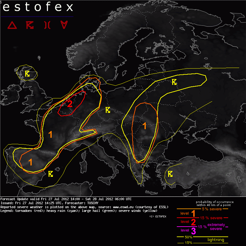
Estofex update level 2:
DISCUSSION
... France, Benelux, Germany and NW Italy ...
Isolatd to scattered convective initiation (CI) is forecast during the day with scattered to widespread coverage after sunset. Despite lowering mid-level geopotential heights, strong thermal ridge is still placed over most of France/Germany. However, strong diabatic heating is likely, so convective temperatures will exceed the required threshold during the day. At upper levels, weak waves traverse the area from SW to NE (becoming stronger betimes due to stronger cyclonic curvature of the flow) and numerous PV streamers also affect those areas, so CI can occur everywhere. The most likely CI during the daytime hours probably exists along the fringe of the thermal ridge, namely NW/N France and Benelux into NW Germany. Further to the south over C/S-France and S-Germany, CI will be bound to topography (at least until sunset).
During the evening hours onwards, a pronounced short wave crosses France and parts of Germany and provides adequate lift for numerous overnight thunderstorm clusters, which then also affect C-France/Germany.
Shear will be on the moderate side with DLS in the order of 10-15 m/s, increasing to 20 m/s over far N-France and Benelux and far S-France. Shear in the lowest 3 km remains marginal during the day but increases to 15 m/s as the short wave approaches during the night. A rather pronounced MLCAPE axis of 1500 J/kg evolves from W-France all the way towards Benelux. This amount of CAPE and aforementioned shear magnitude assist in organized multicell thunderstorms and isolated supercells during the day, the latter risk mainly over Benelux and far NW Germany, where the passage of a weak 'wave' increases SRH. Large hail, heavy rain and a few strong downburst events are forecast although we do not want to rule out an isolated very large hail event with any longer-lived storm. Thunderstorms may already grow upscale into a first MCS event mainly over Benelux during the afternoon hours. In that case, a concentrated swath of strong to severe wind gusts would be a distinct possibility. However, weak forcing and marginal wind field beneath 3 km next to mixed model signals preclude a level 2 upgrade for now. As a side note, in the 18Z model runs, there are more signs of an environment, conducive for enhanced supercell probabilities over Benelux (stronger 3km shear, enhanced SRH-3). If this trend continues, an upgrade may be needed tomorrow during the day.
Isolated storms over Germany will be slow moving with good mid-tropospheric moisture present, so heavy rain accompanies that activity, next to isolated large hail.
During the evening hours and the night, numerous storm clusters (probably organized into numerous MCS events) bring strong to severe wind gusts, isolated large hail and heavy rain to France/parts of Germany and Benelux. Again, weakening CAPE and moderate wind field next to the magnitude of the expected forcing do not inidcate any area with a risk of a concentrated swath of severe wind gusts for now and hence a broad level 1 remains in place.
We expanded the level 1 towards NW Italy and parts of Switzerland as a few severe mountain storms are expected with an overlap of 20 m/s DLS and up to 1kJ/kg MLCAPE. Large hail, strong wind gusts and heavy rain will be the main hazard, also affecting SW/S-Switzerland before gradually weakening during the night.
Wat doen de capes?
what's your life worth when it's boring? Stop wasting your life ,you only live life once.
 Op
Op 
The main reason for updating/upgrading the outlook is the healthy looking cyclonic vortex in model data, which crosses Benelux and far NW Germany during the overnight hoursquote:
Also, we now expect a gradually evolving LL depression with this vorticity maximum, which enhances convergence over Benelux during the night. In fact, a quasi-stationary SW-NE aligned convergence zone is forecast, as both features slowly move to the NE.
Ik pak alvast me camera's in
<a href="http://www.vwkweb.nl/" rel="nofollow" target="_blank">[b]Vereniging voor weerkunde en klimatologie[/b]</a>
<a href="http://www.estofex.org/" rel="nofollow" target="_blank">[b]ESTOFEX[/b]</a>
<a href="http://www.estofex.org/" rel="nofollow" target="_blank">[b]ESTOFEX[/b]</a>
Troost je, zelfs dat valt tegen. Het lijkt meer dan het is.quote:
[ afbeelding ]
Alleen Limburg weer hoor
Ok, we wachten afquote:
Vooralsnog is het hier heel drukkend en heet. Echt te warm om iets anders te doen dan zwemmen. En toch vind ik het jammer dat het warme weer weer bijna voorbij is
Wordt volgens mij echt een heftige nacht als ik de tekst enzo lees.quote:
[..]
The main reason for updating/upgrading the outlook is the healthy looking cyclonic vortex in model data, which crosses Benelux and far NW Germany during the overnight hours
Also, we now expect a gradually evolving LL depression with this vorticity maximum, which enhances convergence over Benelux during the night. In fact, a quasi-stationary SW-NE aligned convergence zone is forecast, as both features slowly move to the NE.
Ik pak alvast me camera's in

Ik parkeer mijn auto voor de zekerheid even aan de "hoge" kant van de straat  . Twee jaar terug, toen in augustus hier wateroverlast was, is mijn vorige autootje verzopen
Ik ga nu naar m'n stekkie toe... hopelijk is de aankomende cell intressant genoeg

<a href="http://www.vwkweb.nl/" rel="nofollow" target="_blank">[b]Vereniging voor weerkunde en klimatologie[/b]</a>
<a href="http://www.estofex.org/" rel="nofollow" target="_blank">[b]ESTOFEX[/b]</a>
<a href="http://www.estofex.org/" rel="nofollow" target="_blank">[b]ESTOFEX[/b]</a>
Nee hoor!!quote:
 Op
Op Ik wil het niet. Mensen uit het westen mogen het gratis komen halen hier, ik ben de moeilijkste niet
Tante minthy!! O+
Achtbaan1 is voor mij te intens
Achtbaan1 is voor mij te intens

Regen in Breda. Al wil het nog niet echt doorzetten, in dit tempo verdampt het al voor de planten er wat aan hebben.
en....wat zag jequote:
“Loop niet voor me, want ik volg niet.
Loop niet achter me, want ik leid niet.
Loop gewoon naast me en wees mijn vriend.”
Loop niet achter me, want ik leid niet.
Loop gewoon naast me en wees mijn vriend.”
healthy looking cyclonic vortex...ik bedoel maar. Vette X factor met kloonkoppen, precies zoals mijn CRESTA op de vensetrbank al voorspelde. Veel clusterwind ookquote:
[..]
[b]The main reason for updating/upgrading the outlook is the healthy looking cyclonic vortex in model data, which crosses Benelux and far NW Germany during the overnight hours
http://www.mrwonkish.nl Eurocrisis, Documentaires, Economie
Even zelf een kaartje gemaakt... Dat gaat dus de komende uren flink activeren en clusteren tot een MCS.


Kon het noodweer niet eerder komen? heb zin in verkoeling, een shelf en dan onweer terwijl de zon onder gaat.
En morgen een festival , gelukkig duurt het maar tot middernacht want anders vrees ik dat ik door slaapgebrek omval.
En morgen een festival , gelukkig duurt het maar tot middernacht want anders vrees ik dat ik door slaapgebrek omval.
Neil LOVES Carrots!
Voordat dat allemaal hier is, is het al afgezwakt in regen, zet je hoop maar niet te hoog in.quote:
Even zelf een kaartje gemaakt...
[ afbeelding ]
ja hoor, dank je welquote:
[..]
Knmi zegt tussen 17:00 en 6:00 's morgens. Ergens daartussen in zal de wolk je dus bereiken. Misschien ook wel niet. Ik hoop dat dit je vraag beantwoord
“Loop niet voor me, want ik volg niet.
Loop niet achter me, want ik leid niet.
Loop gewoon naast me en wees mijn vriend.”
Loop niet achter me, want ik leid niet.
Loop gewoon naast me en wees mijn vriend.”
Misschien moet ik mijn autootje niet alleen aan de hoge kant van de straat parkeren, maar een hele wijk hogerquote:
Even zelf een kaartje gemaakt... Dat gaat dus de komende uren flink activeren en clusteren tot een MCS.
[ afbeelding ]