WKN Weer, Klimaat en Natuurrampen
Lees alles over het onstuimige weer op onze planeet, volg orkanen en tornado's, zie hoe vulkanen uitbarsten en hoe Moeder Aarde beeft bij een aardbeving. Alles over de verwoestende kracht van onze planeet en tal van andere natuurverschijnselen.


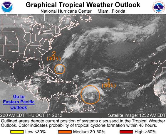
70% nu... lijkt Nadine te worden maar vooralsnog lijkt ze de koers van Leslie/Michael achter na te gaan

quote:Rest of Atlantic Hurricane Season: Most Storms to Avoid U.S
A weather pattern that developed over the central and eastern United States during early September will continue to act as a buffer against major tropical systems through the end of the month.
There is also a possibility the same pattern holds through much of the balance of this Atlantic hurricane season.
According to Expert Senior Meteorologist Dan Kottlowski, head of the AccuWeather.com Hurricane Center, "Westerly winds have broken through over the middle and upper levels of the atmosphere over the central and eastern U.S. and nearby coastal waters."
These winds and the dry air they bring are generally too disruptive for tropical storms or hurricanes to form in nearby coastal waters and tend to cause tropical systems coming from afar to avoid the Gulf and Atlantic coasts of the U.S.
There are some areas that are still somewhat vulnerable to direct impact from a tropical storm or hurricane, if they form.
"The most likely candidates would be the Caribbean islands, Central America, Atlantic Canada and the islands of Bermuda and the Azores in the Central Atlantic," Kottlowski said.
It is not uncommon to see the westerlies break through later in October and November over the U.S. and to have brief episodes of the same during September and early October.
"We keep seeing an upper-level trough of low pressure reappear in the central and eastern U.S. this month with only very brief episodes when it is not present," Kottlowski added.
There is still a chance that a window of opportunity opens up for a tropical system to move close to or form near the U.S., but the persistence of the trough pattern tends to cut the odds.
According to Expert Senior Meteorologist Brett Anderson, "During this October, it is possible the southern extent of the trough becomes shallow enough for less wind shear and dry air in the Gulf of Mexico, but that in itself is not a guarantee for development."
All it takes is one storm sneaking in during one of those open windows, and as we have seen with Isaac, it does not have to be a Category 3 or higher hurricane to cause major damage and endanger lives. Isaac was officially a Category 1 hurricane at landfall.
As of the week ending Sept. 21, the only two systems of note in the Atlantic were Nadine, near the Azores, and a potential system between Bermuda and the Azores.
While the rest of September appears as though it will be quiet for the U.S. mainland, there have been some destructive and deadly storms during October.

Zal me benieuwen of Jelawat de cat.5 nog gaat halen
Veel water voor de Filipijnen en daarna richting Taiwan/Japan en misschien Korea?


Veel water voor de Filipijnen en daarna richting Taiwan/Japan en misschien Korea?


quote:Tyfoon maakt slachtoffers op de Filipijnen
Een hevige tyfoon heeft op de Filipijnen duizenden mensen op de vlucht gejaagd en twee dodelijke slachtoffers geëist. 'Jelawat' won vandaag langs de oostelijke kust op weg naar het noorden nog aan kracht, aldus de weerdiensten. De tyfoon haalt windsnelheden van 240 kilometer per uur.
Het beheer van natuurrampen heeft haar eenheden in de hoogste staat van paraatheid gebracht. In het zuiden van het land zorgde de hevige regen voor overstromingen. Een vijfjarige jongen kwam om toen hij door een omgewaaide boom geraakt werd. Een 31-jarige man werd door de bliksem getroffen. Daarnaast is een 27-jarige vermist in het zuiden van de eilandstaat.
In de zuidelijke provincie Zamboanga del Norte moesten ongeveer 2.000 bewoners in veiligheid gebracht worden. Daar viel in een 800 kilometer lange zone hevige regen. Enkele straten raakten versperd door aardverschuivingen. Het water staat op sommige plaatsen een meter hoog.
De stad Zamboanga riep de noodtoestand uit, waardoor het gebied financiële steun krijgt. Volgens burgemeester Celso Lobregat hebben 9.000 mensen dringend hulp nodig.
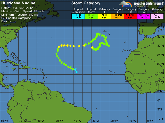
11 september begonnen... die Nadine.. nu dus 17 dagen... Wil ze in de top 5 komen van langstdurende tropische stormen moet ze het nog vijf dagen volhouden.
Al is ze tussentijds "weg" weggeweest en heeft ze zich nadien herontwikkeld...geen idee hoe dat telt
Al is ze tussentijds "weg" weggeweest en heeft ze zich nadien herontwikkeld...geen idee hoe dat telt


60% voor nieuwe INVEST
de modellen sturen deze echter ook weer naar het noorden. Einde van het seizoen kon al wel eens in zicht zijn

de modellen sturen deze echter ook weer naar het noorden. Einde van het seizoen kon al wel eens in zicht zijn

oude blogquote:First of all it is a little rare for an October hurricane to strike in the U.S. but not at all impossible. It has happened 11 times since 1950 so on average there is approximately one occurrence per 5 years. There are definitely preferred areas for them to strike in October, although in the distant past some unique landfall locations have occurred. Since 1950, here are the October hurricane counts by state; Florida followed by Louisiana, that have been visited most often:
Florida Louisiana Texas North/South Carolina
6 3 1
We wachten af en zien wel wat er gaat gebeuren.
Ze gaan de zwaardere winterstormen nu ook namen geven in de VS lees ik
[ Bericht 1% gewijzigd door Frutsel op 02-10-2012 21:11:44 ]
quote:U.S. winter storm names for winter of 2012 - 2013
Athena -- The Greek goddess of wisdom, courage, inspirations, justice, mathematics and all things wonderful
Brutus -- Roman Senator and best known assassin of Julius
Caesar -- Title used by Roman and Byzantine Emperors
Draco -- The first legislator of Athens in Ancient
Euclid -- A mathematician in Ancient Greece, the Father of Geometry
Freyr -- A Norse god associated with fair weather, among other things
Gandolf -- A character in a 1896 fantasy novel in a pseudo-medieval countryside
Helen – In Greek mythology, Helen of Troy was the daughter of Zeus
Iago -- Enemy of Othello in Shakespeare’s play, Othello
Jove -- The English name for Jupiter, the Roman god of light and sky.
Kahn -- Mongolian conqueror and emperor of the Mongol Empire
Luna -- The divine embodiment of the moon in Roman mythology
Magnus -- The Father of Europe, Charlemagne the Great, in Latin: Carolus Magnus
Nemo -- A Greek boy’s name meaning “from the valley”, means “nobody” in Latin
Orko -- The thunder god in Basque mythology
Plato -- Greek philosopher and mathematician, who was named by his wrestling coach
Q -- The Broadway Express subway line in New York City
Rocky -- A single mountain in the Rockies
Saturn -- Roman god of time, among other things who had a planet named after him
Triton -- In Greek mythology, the messenger of the deep sea, son of Poseidon
Ukko -- In Finnish mythology, the god of the sky and weather
Virgil -- One of ancient Rome’s greatest poets
Walda -- Name from Old German meaning “ruler”
Xerxes -- The fourth king of the Persian Achaemenid Empire, Xerxes the Great
Yogi -- People who do yoga
Zeus -- In Greek mythology, the supreme ruler of Mount Olympus and the gods who lived there
[ Bericht 1% gewijzigd door Frutsel op 02-10-2012 21:11:44 ]
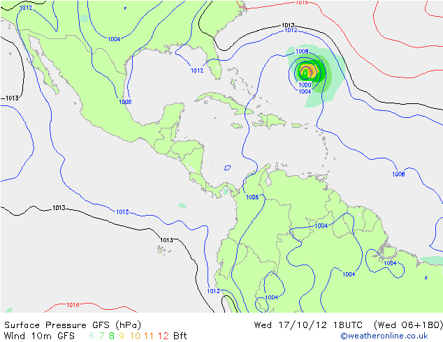
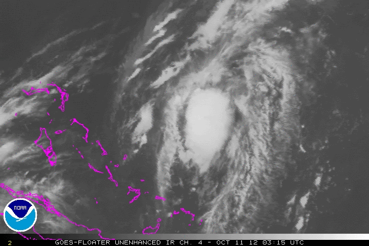
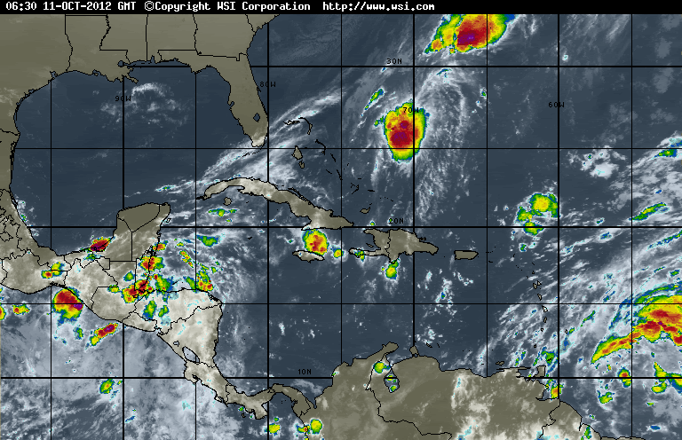
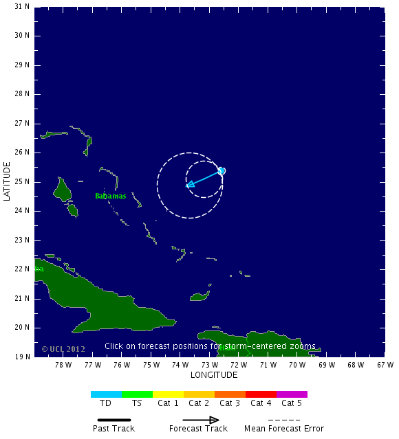
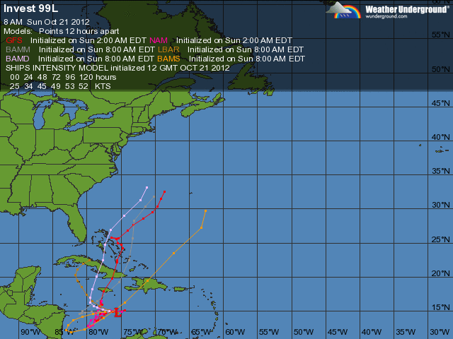
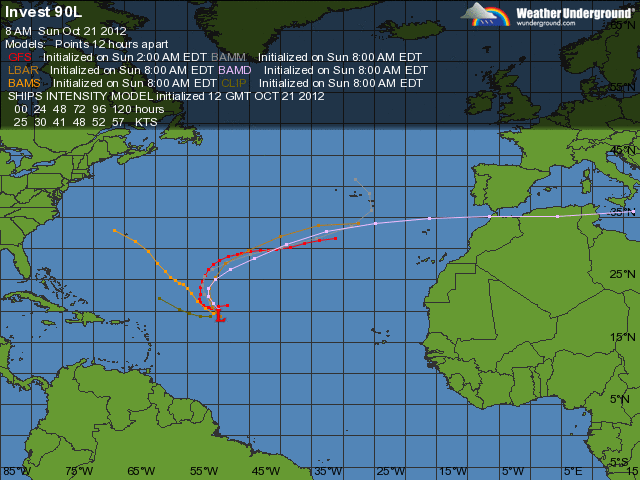
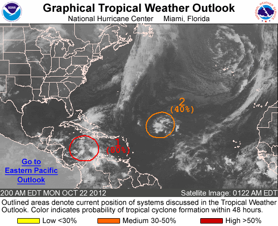
zou 98L in de Atlantic nog voor een verrassing kunnen zorgen?
TWU zegt dat begin volgende week kans bestaat op verder ontwikkeling
TWU zegt dat begin volgende week kans bestaat op verder ontwikkeling
quote:A tropical wave located about 500 miles east of the Lesser Antilles Islands (Invest 98L) is headed west-northwest at about 15 mph, and is a threat to develop into a tropical depression early next week. The disturbance has a modest amount of spin and a large amount of disorganized heavy thunderstorms, as seen on satellite loops, but there is no sign of a surface circulation. Wind shear is a moderate 10 - 20 knots over 98L, the atmosphere is moist, and ocean temperatures are a very warm 30°C. With wind shear expected to rise to the high range, 20 - 30 knots, Wednesday night though Friday, any development the next few days should be slow. The shear is due to an upper-level trough of low pressure centered a few hundred miles northeast of the Lesser Antilles Islands. Once 98L passes beyond the Lesser Antilles on Saturday, the shearing winds of the trough will diminish to the moderate range, 10 - 20 knots. Most of the models predict that 98L will show increasing development beginning on Saturday. The NOGAPS model has 98L developing into a tropical depression on Monday, a few hundred miles northeast of the southeastern Bahama Islands. The GFS model is much slower with the system, predicting it will develop into a tropical depression on Monday, a few hundred miles north of Puerto Rico. Moisture from 98L should affect the Lesser Antilles Islands on Thursday and Friday, and Puerto Rico and the Virgin Islands on Friday and Saturday. It is uncertain if heavy rains from 98L will affect the Dominican Republic early next week; the storm may stay too far to the northeast. In their 8 am Tropical Weather Outlook, NHC gave 98L a 30% chance of becoming a tropical cyclone by Friday morning. The long range fate of 98L is uncertain; the ECMWF model shows 98L becoming absorbed by a cold front and bringing heavy rains to Canada and New England on Tuesday and Wednesday next week, while the GFS and NOGAPS models predict that 98L will stay out to sea for at least the next week.
kan idd nog wat gaan worden. Modellen zijn het niet eens over de koers.quote:Op woensdag 10 oktober 2012 16:49 schreef Frutsel het volgende:
zou 98L in de Atlantic nog voor een verrassing kunnen zorgen?
[ afbeelding ]
TWU zegt dat begin volgende week kans bestaat op verder ontwikkeling
[..]


quote:Rafael richting Bermuda
De tropische storm Rafael, die afstevent op Bermuda, is boven de Atlantische Oceaan aangezwollen tot orkaankracht. Dat meldt het Amerikaanse National Hurricane Center.
De negende tropische storm van het Atlantische orkaanseizoen heeft windsnelheden van boven de 120 kilometer per uur bereikt. Naar verwachting zal Rafael vandaag Bermuda ten oosten passeren.
Bermuda is een rijk Brits overzees gebied dat in de periode juni tot november wordt geteisterd door stormen en orkanen. Het eiland is goed voorbereid en grote schade of slachtoffers zijn zeldzaam.
Boven de Stille Oceaan koerst orkaan Paul intussen af op de westkust van Mexico. De storm wordt dinsdagavond (plaatselijk tijd) boven land verwacht en is inmiddels afgezwakt van categorie 3 naar 2, aldus het Hurricane Center. Voor het gebied Santa Fe, Punta Abrejos tot het westelijke Baja Peninsula is een orkaanwaarschuwing afgegeven.
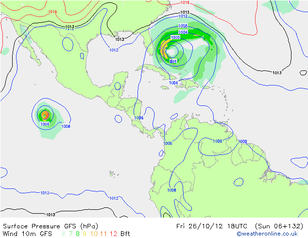
Even in de gaten houden... Bastardi zegt er volgende over 
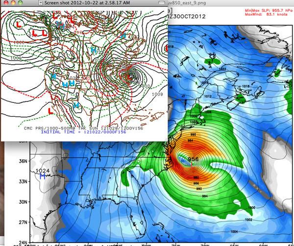
twitter:BigJoeBastardi twitterde op maandag 22-10-2012 om 09:00:48 Ecmwf/Canadian continue in weatherbell camp of possible historic weather event on east coast. GFS looks out of touch http://t.co/AxfxkeCo reageer retweet
 Ecmwf/Canadian continue in weatherbell camp of possible historic weather event on east coast. GFS looks out of touch
 twitter:BigJoeBastardi twitterde op maandag 22-10-2012 om 14:56:24 if Sandy gets trapped, pulled in,would be once in a lifetime event for east. hurricane hitting coast, heavy snows mtns west reageer retweet
twitter:BigJoeBastardi twitterde op maandag 22-10-2012 om 14:58:22 The amazing thing about all this is the PATTERN argues for it.. large scale very similar to Hazel, 1954. Weatherbell posts, video, discuss reageer retweet
twitter:BigJoeBastardi twitterde op maandag 22-10-2012 om 14:59:01 The other 2 options.. Wilma, escaping hurricane but storm forms anyway, lashes ne, but not as bad, and the least likely, nothing reageer retweet

Ben benieuwd. Het is nog niet gedaan in de atlantic..quote:
Even in de gaten houden... Bastardi zegt er volgende over
[ afbeelding ]twitter:BigJoeBastardi twitterde op maandag 22-10-2012 om 09:00:48 Ecmwf/Canadian continue in weatherbell camp of possible historic weather event on east coast. GFS looks out of touch http://t.co/AxfxkeCo reageer retweettwitter:BigJoeBastardi twitterde op maandag 22-10-2012 om 14:56:24 if Sandy gets trapped, pulled in,would be once in a lifetime event for east. hurricane hitting coast, heavy snows mtns west reageer retweettwitter:BigJoeBastardi twitterde op maandag 22-10-2012 om 14:58:22 The amazing thing about all this is the PATTERN argues for it.. large scale very similar to Hazel, 1954. Weatherbell posts, video, discuss reageer retweettwitter:BigJoeBastardi twitterde op maandag 22-10-2012 om 14:59:01 The other 2 options.. Wilma, escaping hurricane but storm forms anyway, lashes ne, but not as bad, and the least likely, nothing reageer retweet

Worden de orkanen in de USA elk jaar verwoestender of lijkt dat maar zo doordat er steeds meer een media-spektakel van gemaakt word?
Ik denk vooral dat laatstequote:Op maandag 29 oktober 2012 15:17 schreef kibo het volgende:
Worden de orkanen in de USA elk jaar verwoestender of lijkt dat maar zo doordat er steeds meer een media-spektakel van gemaakt word?
Zie andere topicquote:
Worden de orkanen in de USA elk jaar verwoestender of lijkt dat maar zo doordat er steeds meer een media-spektakel van gemaakt word?
Afgelopen jaren hebben de VS nauwelijks te maken gehad met zware orkanen. Irene was vorig jaar een gevaarlijke (en had een Sandy kunnen doen) en ze draaide nog net op tijd af maar maakte wel voor 19 miljard schade.
Maar vergeleken met andere jaren zoals 2004, 2005.
Wat dat betreft hebben ze de laatste jaren 'mazzel' gehad. Zo heeft ook Haïti na de zware aardbevingen van enkele jaren geleden elke keer 'geluk' gehad dat het niet door een zware orkaan is getroffen. 2005 wordt gezien als het ultieme jaar. Ik meen om en nabij de 150-160 miljard schade.
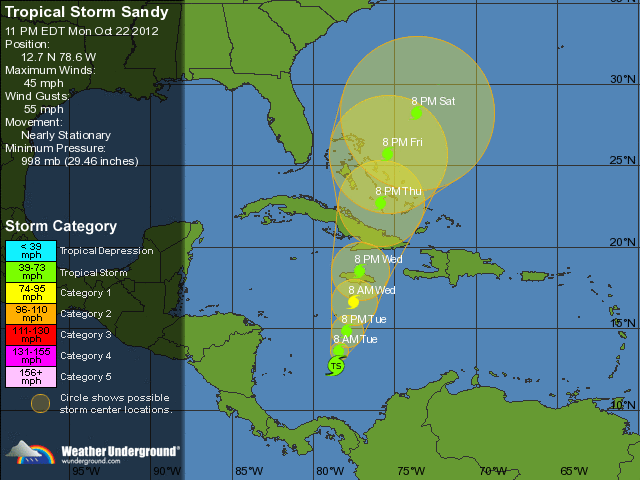
Hurricane Sandy
Ik neem aan dat ik vanavond en vannacht hier weer een uitgebreid verslag kan verwachten?
Ik neem aan dat ik vanavond en vannacht hier weer een uitgebreid verslag kan verwachten?
Topic(s) staat hierquote:Op maandag 29 oktober 2012 18:20 schreef bazb het volgende:
Hurricane Sandy
Ik neem aan dat ik vanavond en vannacht hier weer een uitgebreid verslag kan verwachten?
Orkaan Sandy op ramkoers met Amerikaanse oostkust #2
LIVE politie scanner New York
ALERT Feeds
Hele waslijst aan live audio feeds
National Hurricane Center Skywarn Nets - Echolink Node 7203, IRLP Node 9129 Live Audio Feed
Voor audio uit Delaware
Voor audio uit Maryland
Voor audio uit New Jersey
Voor audio uit New York
Klik op luidspreker voor de audio feed
[ Bericht 4% gewijzigd door -CRASH- op 29-10-2012 22:24:02 ]
<a href="http://www.vwkweb.nl/" rel="nofollow" target="_blank">[b]Vereniging voor weerkunde en klimatologie[/b]</a>
<a href="http://www.estofex.org/" rel="nofollow" target="_blank">[b]ESTOFEX[/b]</a>
<a href="http://www.estofex.org/" rel="nofollow" target="_blank">[b]ESTOFEX[/b]</a>

Inderdaad.
Zie ook Orkaan Sandy op ramkoers met Amerikaanse oostkust #3
Totale schade zal wel over de 15-20 miljard gaan... maar nog altijd klagen mensen dat het een stormpje van nix is. Uiteraard moeten er eerst 2000 mensen dood... en dat zijn dan Amerikanen dus dat is ook niet zo erg
Zie ook Orkaan Sandy op ramkoers met Amerikaanse oostkust #3
Totale schade zal wel over de 15-20 miljard gaan... maar nog altijd klagen mensen dat het een stormpje van nix is. Uiteraard moeten er eerst 2000 mensen dood... en dat zijn dan Amerikanen dus dat is ook niet zo erg
https://itunes.apple.com/(...)dio/id499955111?mt=8. Voor iPad/pod/phonequote:
LIVE politie scanner New York
ALERT Feeds
Hele waslijst aan live audio feeds
National Hurricane Center Skywarn Nets - Echolink Node 7203, IRLP Node 9129 Live Audio Feed
Voor audio uit Delaware
Voor audio uit Maryland
Voor audio uit New Jersey
Voor audio uit New York
Klik op luidspreker voor de audio feed