WKN Weer, Klimaat en Natuurrampen
Lees alles over het onstuimige weer op onze planeet, volg orkanen en tornado's, zie hoe vulkanen uitbarsten en hoe Moeder Aarde beeft bij een aardbeving. Alles over de verwoestende kracht van onze planeet en tal van andere natuurverschijnselen.


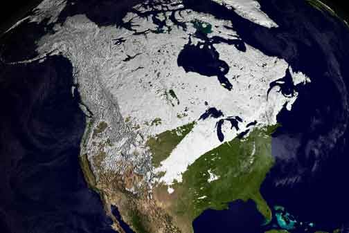
Winter in noord Amerika
Halverwege september begint de kou op het noordelijk halfrond zich weer langzaam uit te breiden richting het zuiden. In het hoge noorden van Canada zakt de temperatuur alweer onder het vriespunt en valt alweer de eerste sneeuw. De bedoeling van dit topic is om het nieuws rond de winter in noord Amerika te volgen. Nieuws, foto's, video's etc etc zijn hier welkom.
Winter in Canada
In de winter is het koud in het noorden en het midden. Temperaturen dalen daar gemakkelijk tot -30 graden. Op 1 februari werd in Snag de allerlaagste Canadese temperatuur bereikt van -62.8 graden. Alleen het uiterste westen heeft een mild klimaat. In Vancouver komt het minste vorst voor.
Noord Canada
Zuid Canada
Oost Canada
De noordoostelijke staten van de USA
De winter in New England staat bekend als een koude winter. De wind is in het winterhalfjaar noordwestelijk en droge arctische lucht uit Canada stroomt ver naar het zuiden. Deze kou-invallen gaan soms gepaard met blizzards. Opdringende warme lucht uit het zuiden zorgt af en toe voor flinke ijzel.
Gemiddeld vriest het bij de Canadese grens in januari zo'n -13 graden. In New Jersey vriest het zo'n 5 graden. In het noordoostelijke puntje van New England daalt in januari de thermometer gemiddeld elke nacht tot -19 graden. De extremen in het gebied liegen er ook niet om. Op 19 januari werd het in Van Buren (Maine) -44,4 graden. Old Forge (New York) mat op 18 februari 1979 zelfs een minimum van -46,7 graden. Het zeewater daalt in januari en februari tot +4 graden in zowel Boston als in New York.
De zuidoostelijke staten van de USA
In de winter komt de gemiddelde kou tot Atlanta. In Maryland, Virginia, de Appalachen en de hoger gelegen staten als Kentucky vriest het veelvuldig. De ergste kou vinden we nog noordelijker in Michigan en Ontario. In West Virginia vinden we de allerlaagste temperatuur van het gebied terug. Op 30 december 1917 daalde in Lewisburg de thermometer tot -38,3 graden.
Het gebied langs de Golf van Mexico beleeft een relatief milde en korte winter. Toch kan het hier soms flink vriezen. Neem bijvoorbeeld de -28 graden die in Corinth (Mississippi) op 30 januari 1966 werd gemeten. In Florida neemt de invloed van de oceaan toe. Dit is vooral merkbaar aan de gemiddelde nachttemperatuur in het zuiden. In zeer uitzonderlijke situatie vriest het hier of valt er sneeuw. Op de Key's komt de temperatuur nooit onder nul. De allerlaagste temperatuur in Florida bedroeg -18,9 graden en werd gemeten in Tallahassee.
De staten Virginia, West Virginia en Maryland krijgen in de winter soms te maken met sneeuwstormen. Deze staan bekend als Nor'easters en komen oktober en april. Ze zijn berucht om de grote hoeveelheid sneeuw, regen en de flinke wind.
Een Nor'easter komt voor als een lagedrukgebied warme vochtige subtropische lucht uit de Golf van Mexico naar het noorden voert. De lucht wordt vermengd met vochtige lucht uit de Atlantische Oceaan. Een hogedrukgebied boven Canada biedt tegenwicht en stuwt arctische lucht naar het zuiden. Daar waar de luchtsoorten bij elkaar komen, ontstaat hevige neerslag.
De meest actieve Nor'easter is de sneeuwstorm die naar het oosten trekt en de straalstroom volgt. Vooral Washington DC, Philadelphia, New York City en Boston worden dan getroffen en krijgen grote hoeveelheden regen en sneeuw te verwerken.
Het midden van de Verenigde Staten
De winters in het noorden zijn streng. Bismarck in North Dakota heeft in januari een gemiddelde temperatuur van -12,7 graden. International Falls op de grens van Canada en Minnesota heeft zelfs een gemiddelde januari-temperatuur van -17,2 graden. De nachtelijke temperaturen bedragen hier gemiddeld -23,3 graden en de dagtemperatuur -11,2 graden.
De staten langs de Canadese grens en de Grote Meren krijgen ook in de winter vaak te maken met 'blizzards', die zeer koude lucht aanvoeren vanuit het arctische Canada. Het gebied is dan bedekt met een sneeuwlaag. Veel is dit niet. In januari valt er slechts enkele tientallen millimeters neerslag.
Veel nachten verlopen helder en de aanwezigheid van een sneeuwdek helpt mee aan een lage temperatuur. De allerlaagste temperatuur in North Dakota werd gemeten op 15 februari 1936. In Parshall werd het -51,1 graden. Op 2 februari 1996 gebeurde hetzelfde in Towar, Minnesota.
Naar het zuiden neemt de strengheid van de winter af. Tot in Kansas is de gemiddelde januaritemperatuur onder nul. In Texas loopt deze snel op. Niet alleen de zuidelijke ligging, maar ook de aanwezigheid van de Golf van Mexico speelt daarbij een rol. In Brownsville op de grens met Mexico is het in januari overdag 20,5 graden en incidenteel boven de 33 graden.
Toch krijgen relatief zuidelijk gelegen gebieden 's winters soms te maken met extreme koude situaties, doordat luchtstromen uit het hoge noorden van Canada hun weg zuidwaarts zoeken tussen de Rocky Mountains en de Appalachen. Zo was het in het ogenschijnlijk warme Texas op 3 februari 1933 in Seminole -30,6 graden.
Westen van de Verenigde Staten
In de winter heerst de meeste kou in de hoger gelegen delen van de Rocky Mountains. Arctische lucht uit Canada zorgt voor strenge winters in het noorden, zoals in Montana, Wyoming en Colorado. In Montana richt de snijdend koude wind geregeld slachtingen aan onder de veestapel. De allerlaagste temperatuur in Montana werd gemeten op 20 januari 1954. Op Rogers Pass werd het toen -56,7 graden onder nul.
In Wyoming waar ook lange strenge winters voorkomen, staat het minimumrecord op bijna -53 graden vorst. Het berggebied van Idao, Utah en Colorado is koud en sneeuwachtig. Vooral in Colorado valt veel sneeuw. Temperaturen tot onder de -50 graden zijn incidenteel mogelijk. De hoogvlakte van Nevada is eveneens koud. In Ely op 1900 meter hoogte vriest het in januari 's nachts zo'n -12,5 graden. Dit wordt tevens veroorzaakt door de vele heldere nachten in het gebied.
Warmer is het in Washington en Oregon. Het kan hier behoorlijk vriezen, maar aan zee is de winter relatief mild. De regen valt vooral tussen oktober en april. In de bergen gaat het dan om sneeuw en worden wegen afgesloten.
In het zuidwesten van Californië blijft het winters klimaat aangenaam en vriest het zelden. Het is daar dan ook regentijd. Toch kan de winter flink uithalen. Vooral in de Sierra Nevada is dat het geval. De allerlaagste temperatuur in Californië die is gemeten bedraagt -42,8 graden. In New Mexico tenslotte zijn de winters koel maar niet extreem koud.
Alaska
In de noordelijke Amerikaanse staat Alaska heersen verschillende klimaten. Zeestromingen, bergruggen en een lage zonnestand bepalen voornamelijk het klimaat. In het noorden komen poolwoestijnen voor, in het zuiden heerst een mild klimaat dat vergelijkbaar is met Nederland.
Bron:
De bedoeling van dit Topic is om het winterweer in Noord Amerika te volgen.
B.v. via onderstaande site's
Weather Channel
Accuweather
Winter Weather cnn
Google News
vorige delen:
Topic Winterweer in de V.S: Snow, Blizzards and Storms (2007)
Winterweer in de VS (2008) - IJsstorm en bar winterweer
Winter in de V.S. (2009/2010)
Winter in de V.S. (2010/2011)
Nieuws over de noord/zuidpool kan in onderstaande topic geplaatst worden:
Poolkappen, IJsbergen en Gletsjers #3
De huidige temperaturen in Canada
De huidige temperaturen in de V.S.
De huidige temperaturen in Alaska
Kaartje waarop de sneeuwhoogte en uitbreiding van het noordpoolijs is te volgen.
[ Bericht 0% gewijzigd door Frutsel op 05-10-2011 10:22:57 ]
Halverwege september begint de kou op het noordelijk halfrond zich weer langzaam uit te breiden richting het zuiden. In het hoge noorden van Canada zakt de temperatuur alweer onder het vriespunt en valt alweer de eerste sneeuw. De bedoeling van dit topic is om het nieuws rond de winter in noord Amerika te volgen. Nieuws, foto's, video's etc etc zijn hier welkom.
Winter in Canada
In de winter is het koud in het noorden en het midden. Temperaturen dalen daar gemakkelijk tot -30 graden. Op 1 februari werd in Snag de allerlaagste Canadese temperatuur bereikt van -62.8 graden. Alleen het uiterste westen heeft een mild klimaat. In Vancouver komt het minste vorst voor.
Noord Canada
Zuid Canada
Oost Canada
De noordoostelijke staten van de USA
De winter in New England staat bekend als een koude winter. De wind is in het winterhalfjaar noordwestelijk en droge arctische lucht uit Canada stroomt ver naar het zuiden. Deze kou-invallen gaan soms gepaard met blizzards. Opdringende warme lucht uit het zuiden zorgt af en toe voor flinke ijzel.
Gemiddeld vriest het bij de Canadese grens in januari zo'n -13 graden. In New Jersey vriest het zo'n 5 graden. In het noordoostelijke puntje van New England daalt in januari de thermometer gemiddeld elke nacht tot -19 graden. De extremen in het gebied liegen er ook niet om. Op 19 januari werd het in Van Buren (Maine) -44,4 graden. Old Forge (New York) mat op 18 februari 1979 zelfs een minimum van -46,7 graden. Het zeewater daalt in januari en februari tot +4 graden in zowel Boston als in New York.
De zuidoostelijke staten van de USA
In de winter komt de gemiddelde kou tot Atlanta. In Maryland, Virginia, de Appalachen en de hoger gelegen staten als Kentucky vriest het veelvuldig. De ergste kou vinden we nog noordelijker in Michigan en Ontario. In West Virginia vinden we de allerlaagste temperatuur van het gebied terug. Op 30 december 1917 daalde in Lewisburg de thermometer tot -38,3 graden.
Het gebied langs de Golf van Mexico beleeft een relatief milde en korte winter. Toch kan het hier soms flink vriezen. Neem bijvoorbeeld de -28 graden die in Corinth (Mississippi) op 30 januari 1966 werd gemeten. In Florida neemt de invloed van de oceaan toe. Dit is vooral merkbaar aan de gemiddelde nachttemperatuur in het zuiden. In zeer uitzonderlijke situatie vriest het hier of valt er sneeuw. Op de Key's komt de temperatuur nooit onder nul. De allerlaagste temperatuur in Florida bedroeg -18,9 graden en werd gemeten in Tallahassee.
De staten Virginia, West Virginia en Maryland krijgen in de winter soms te maken met sneeuwstormen. Deze staan bekend als Nor'easters en komen oktober en april. Ze zijn berucht om de grote hoeveelheid sneeuw, regen en de flinke wind.
Een Nor'easter komt voor als een lagedrukgebied warme vochtige subtropische lucht uit de Golf van Mexico naar het noorden voert. De lucht wordt vermengd met vochtige lucht uit de Atlantische Oceaan. Een hogedrukgebied boven Canada biedt tegenwicht en stuwt arctische lucht naar het zuiden. Daar waar de luchtsoorten bij elkaar komen, ontstaat hevige neerslag.
De meest actieve Nor'easter is de sneeuwstorm die naar het oosten trekt en de straalstroom volgt. Vooral Washington DC, Philadelphia, New York City en Boston worden dan getroffen en krijgen grote hoeveelheden regen en sneeuw te verwerken.

Het midden van de Verenigde Staten
De winters in het noorden zijn streng. Bismarck in North Dakota heeft in januari een gemiddelde temperatuur van -12,7 graden. International Falls op de grens van Canada en Minnesota heeft zelfs een gemiddelde januari-temperatuur van -17,2 graden. De nachtelijke temperaturen bedragen hier gemiddeld -23,3 graden en de dagtemperatuur -11,2 graden.
De staten langs de Canadese grens en de Grote Meren krijgen ook in de winter vaak te maken met 'blizzards', die zeer koude lucht aanvoeren vanuit het arctische Canada. Het gebied is dan bedekt met een sneeuwlaag. Veel is dit niet. In januari valt er slechts enkele tientallen millimeters neerslag.
Veel nachten verlopen helder en de aanwezigheid van een sneeuwdek helpt mee aan een lage temperatuur. De allerlaagste temperatuur in North Dakota werd gemeten op 15 februari 1936. In Parshall werd het -51,1 graden. Op 2 februari 1996 gebeurde hetzelfde in Towar, Minnesota.
Naar het zuiden neemt de strengheid van de winter af. Tot in Kansas is de gemiddelde januaritemperatuur onder nul. In Texas loopt deze snel op. Niet alleen de zuidelijke ligging, maar ook de aanwezigheid van de Golf van Mexico speelt daarbij een rol. In Brownsville op de grens met Mexico is het in januari overdag 20,5 graden en incidenteel boven de 33 graden.
Toch krijgen relatief zuidelijk gelegen gebieden 's winters soms te maken met extreme koude situaties, doordat luchtstromen uit het hoge noorden van Canada hun weg zuidwaarts zoeken tussen de Rocky Mountains en de Appalachen. Zo was het in het ogenschijnlijk warme Texas op 3 februari 1933 in Seminole -30,6 graden.

Westen van de Verenigde Staten
In de winter heerst de meeste kou in de hoger gelegen delen van de Rocky Mountains. Arctische lucht uit Canada zorgt voor strenge winters in het noorden, zoals in Montana, Wyoming en Colorado. In Montana richt de snijdend koude wind geregeld slachtingen aan onder de veestapel. De allerlaagste temperatuur in Montana werd gemeten op 20 januari 1954. Op Rogers Pass werd het toen -56,7 graden onder nul.
In Wyoming waar ook lange strenge winters voorkomen, staat het minimumrecord op bijna -53 graden vorst. Het berggebied van Idao, Utah en Colorado is koud en sneeuwachtig. Vooral in Colorado valt veel sneeuw. Temperaturen tot onder de -50 graden zijn incidenteel mogelijk. De hoogvlakte van Nevada is eveneens koud. In Ely op 1900 meter hoogte vriest het in januari 's nachts zo'n -12,5 graden. Dit wordt tevens veroorzaakt door de vele heldere nachten in het gebied.
Warmer is het in Washington en Oregon. Het kan hier behoorlijk vriezen, maar aan zee is de winter relatief mild. De regen valt vooral tussen oktober en april. In de bergen gaat het dan om sneeuw en worden wegen afgesloten.
In het zuidwesten van Californië blijft het winters klimaat aangenaam en vriest het zelden. Het is daar dan ook regentijd. Toch kan de winter flink uithalen. Vooral in de Sierra Nevada is dat het geval. De allerlaagste temperatuur in Californië die is gemeten bedraagt -42,8 graden. In New Mexico tenslotte zijn de winters koel maar niet extreem koud.

Alaska
In de noordelijke Amerikaanse staat Alaska heersen verschillende klimaten. Zeestromingen, bergruggen en een lage zonnestand bepalen voornamelijk het klimaat. In het noorden komen poolwoestijnen voor, in het zuiden heerst een mild klimaat dat vergelijkbaar is met Nederland.
Bron:
De bedoeling van dit Topic is om het winterweer in Noord Amerika te volgen.
B.v. via onderstaande site's
Weather Channel
Accuweather
Winter Weather cnn
Google News
vorige delen:
Topic Winterweer in de V.S: Snow, Blizzards and Storms (2007)
Winterweer in de VS (2008) - IJsstorm en bar winterweer
Winter in de V.S. (2009/2010)
Winter in de V.S. (2010/2011)
Nieuws over de noord/zuidpool kan in onderstaande topic geplaatst worden:
Poolkappen, IJsbergen en Gletsjers #3


De huidige temperaturen in Canada

De huidige temperaturen in de V.S.

De huidige temperaturen in Alaska

Kaartje waarop de sneeuwhoogte en uitbreiding van het noordpoolijs is te volgen.

[ Bericht 0% gewijzigd door Frutsel op 05-10-2011 10:22:57 ]

Zuid-Alaska heeft een klimaat gelijk met Nederland, wow.
Op vrijdag 18 maart 2011 01:26 [b]schreef Ezio het volgende:[/b]Ik ga nu wel. Kijk uit waar je je staart steekt!
Groetjes, Ezio.
Groetjes, Ezio.

Accuweatherquote:First Frost on the Way for Some Northern States
The chilliest air since last spring will sweep into part of the northern U.S. and neighboring Canada, bringing the first frost of the season to some locations.
A large area of high pressure will build southward from northern Canada and will roll into the northern Plains, Midwest and Northeast U.S. this week.
The much cooler air will first pour into the northern Plains and Canadian Prairies today into Tuesday and will spread into the Northeastern U.S. during the second half of the week.
The forecast magnitude of the chilly shot and the overall high pressure area is a little early for the time of year but has happened before.
The average date of the first frost or freeze is just that, an average.
According to Agricultural Meteorologist Dale Mohler, the greatest risk of damaging frost is over the Upper Midwest.
"The core of the chilly air and necessary clear skies and light winds for frost lies from the eastern Dakotas to much of Minnesota northern Iowa, western Wisconsin, southern Manitoba and part of Northwestern Ontario Wednesday night and Thursday night," Mohler said.
"Farther east, there is still some risk of frost, but the number of hours necessary to damage tender plants and vegetables will be much less and temperatures will be very marginal," Mohler added.
A light frost (associated with marginal temperatures) can leave some plants undamaged. A freeze (prolonged below-freezing temperatures) causes the fluid inside the plant to freeze, destroying the cells. Different plants, because of their cell structure, can resist frost to a certain point.
Mohler was referring to areas east of Chicago to the mid-Atlantic and New England.
The warm waters of the Great Lakes modify temperatures this early in the season. So when an air mass moves in from southern Canada and across the northern Plains, it passes over the Great Lakes, picking up a bit of warmth.
"There will also be cloud cover issues and perhaps some wind working against frost farther east," Mohler added.
The risk of frost is generally for rural locations and open areas in the suburbs. In the larger cities, including those of the Upper Midwest, the heat given off by pavement and buildings should be enough to ward off the risk of frost.
Forecast low temperatures are made for a height about six feet above the ground. In clear, calm situations, the temperature nearest the ground, not including pavement or concrete, can be 10 degrees lower or more. This is why we mention frost when actual temperatures are forecast to be above freezing.
It is possible by next weekend that enough cool air is still around, winds diminish and skies clear to allow frost in the normally cold spots of the mid-Atlantic and New England.
The southward push of cool air across the Great Plains, combined with a storm brewing in the Southwest, could initiate areas of rain to some needy locations farther south, including part of Texas, Oklahoma, New Mexico, Kansas and Colorado.


en toch zul je zien dat heel veel Europeanen in bovengenoemde periode naar de USA trekken en zich niet door dit soort weer laten tegenhouden. 
Yvonne schreef op maandag 31 oktober 2011 @
13:59:43 in DEF SC #282 aan AchJa & Co
Vanaf hier en nu stopt het in DEF én op FOK!
Ik wil hier een normale SC zonder gebitch!
13:59:43 in DEF SC #282 aan AchJa & Co
Vanaf hier en nu stopt het in DEF én op FOK!
Ik wil hier een normale SC zonder gebitch!
En de eerste vorst in de V.S. is een feit. In sommige delen van het midden/noorden is het kwik tot onder het vriespunt gezakt. (rond de -2).
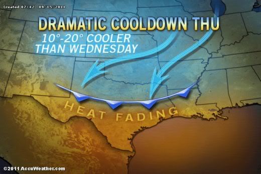
A cold front plowing South will cool temperatures by as much as 30 degrees later this week.
After chilling the northern half of the nation, the cool air originating from Canada will provide much-needed relief for a part of the country that has been dealing with a record-breaking summer.
Nowhere will the change be more evident than across the southern Plains, where high temperatures above the century mark today will be replaced by 70s and 80s for a few days.
Clouds and much-needed rain will help keep temperatures even lower in some locales.
Such a location will be Oklahoma City, where temperatures reached triple digits for a record 62nd time on Monday. Following another hot day today, temperatures will struggle to escape the 60s come Thursday as rain falls.
Charred portions of central and eastern Texas will unfortunately avoid any appreciable rain, but will have the thermometer dip into the 80s for a few days.
Accuweather
Cooler Weather On The Way for Sizzling Southquote:...WIDESPREAD SUB FREEZING TEMPERATURES EXPECTED TONIGHT AND EARLY
THURSDAY MORNING...
.SURFACE HIGH PRESSURE WILL MOVE OVER THE RED RIVER VALLEY THIS
EVENING INTO MINNESOTA BY THURSDAY MORNING. THIS HIGH WILL BRING A
DRY AIRMASS...CLEAR SKY AND LIGHT WINDS TONIGHT INTO EARLY
THURSDAY MORNING RESULTING IN WIDESPREAD IN LOW TEMPERATURES FROM
25 TO 30.

A cold front plowing South will cool temperatures by as much as 30 degrees later this week.
After chilling the northern half of the nation, the cool air originating from Canada will provide much-needed relief for a part of the country that has been dealing with a record-breaking summer.
Nowhere will the change be more evident than across the southern Plains, where high temperatures above the century mark today will be replaced by 70s and 80s for a few days.
Clouds and much-needed rain will help keep temperatures even lower in some locales.
Such a location will be Oklahoma City, where temperatures reached triple digits for a record 62nd time on Monday. Following another hot day today, temperatures will struggle to escape the 60s come Thursday as rain falls.
Charred portions of central and eastern Texas will unfortunately avoid any appreciable rain, but will have the thermometer dip into the 80s for a few days.
Accuweather
Jan Visserquote:In Noord-Amerika heeft zich een overgang naar aanmerkelijk kouder weer voltrokken. Deze doet zich inmiddels ook in een groot deel van de VS gelden. Eindelijk is het op zinderende 'southern Plains' (Texas, Oklahoma) gaan afkoelen (zie kaartje).
Oliver Oeckerath stelde ondertussen een ‘Canadees overzicht’ samen. Ik citeer: “Grootvadertje Vorst is dezer dagen al op bezoek in de Canadese provincie Saskatchewan. Onder invloed van een koudbloedig hogedrukgebied werd het dinsdag in Spiritwood niet warmer dan 8,8° (normaal: 16,8°). De nacht naar woensdag leverde daar met -7,0° de eerste stevige vorst van de herfst en meteen een evenaring van het op 30 september 1996 gevestigde maandrecord op. In het stadje Rosetown, waar voor september een gemiddelde minimumtemperatuur van 3,9° te boek staat, duikelde het kwik zelfs naar -7,7° (record: -8,7°).
Regina, de provinciale hoofdstad (180.000 inwoners), noteerde -5,2°. De bel met koude lucht schuift inmiddels oostwaarts. Gistermiddag bleef ket kwik in Geraldton, Ontario, steken op een magere 6,3° tegen 15,3° normaal. Vanochtend vroeg zijn in het gebied ten noorden van het Bovenmeer (Lake Superior) ook de eerste natte sneeuwbuien van het seizoen mogelijk.
[ Bericht 4% gewijzigd door #ANONIEM op 15-09-2011 13:19:47 ]
quote:La Nina returns
Last month, La Niña conditions returned and are expected to gradually strengthen and continue into the Northern Hemisphere through the 2011/2012 winter, according to a National Oceanic and Atmospheric Administration Climate Prediction Center webinar held Thursday.
During the October through December 2011 period, there is evidence that La Niña favors an increased chance of above-average temperatures across the mid-section of the country, according to the weather forecasters.
The nation’s Corn Belt will feel La Niña’s effects through the end of the year. “Moving into this fall, the Corn Belt region weather conditions are typically warm and dry during La Niña,” said Jon Gottshalk, NOAA Climate Prediction Center. “With La Nina we have a 4 in 5 chance of below normal precipitation for November through March.” Gottshalk added that as the winter months proceed there is a tendency for the northern portion of the Corn Belt to return to colder temperatures.
The effects of La Niña also added to the record drought conditions in the Southern Plains. Much of Texas, Oklahoma and parts of New Mexico and Kansas remain mired in extreme to exceptional drought. The agriculture damage in Texas alone is estimated at $5.2 billion. The climatologists say that weather indicators suggest that drought conditions in the area may remain in place.
According to NOAA, U.S. weather disasters in 2011 exceeding $1 billion in damage set a new record at 10.
August precipitation varied considerably across the Midwest as crop stress became much more widespread with the dry conditions of the month, according to NOAA. Due to the weather and following disappointing field surveys in many locations, crop yield estimates were lowered well below the 5-year averages. Yields are also expected to vary considerably from field to field and even within fields.
Drought affected areas in the Midwest expanded from less than 1% on July 26 to more than 18% on Aug. 30. Severe drought area went from 0% to nearly 5% of the Midwest in the same time period.
For details on the weather and climate events of the Midwest, see the weekly summaries in the

Jan Visserquote:na vijf maanden zijn afgelopen zaterdag (10 september) de laatste resten van de opgestapelde sneeuwbergen in de Canadese stad Edmonton gesmolten (bron: Alexandra Pope).
Zal niet heel lang meer duren voor de eerste sneeuw weer gaat vallen.
Jan Visserquote:Oliver Oeckerath bericht over de afkoeling in het oosten van de Verenigde Staten: “Door toedoen van de restanten van de voormalige tyfoon ROKE, die op 21-22 september jongstleden nog Japan had geteisterd, is het in het oosten van de Verenigde Staten flink afgekoeld. Tijdens het afgelopen weekeinde werd op de toppen van de Appalachen voor het eerst deze herfst een sneeuwdek gevormd. In de staat West Virginia, Pocahontas County, rapporteerde de 1478 meter hoge Snowshoe Mountain (38° noorderbreedte) zondagmiddag een sneeuwhoogte van 10 cm. Maandagochtend lokale tijd wordt er een tapijt van 23 cm verwacht.
Sneeuw van betekenis ook in het oosten van Canada: op de grens van de provincies Québec en Labrador viel in het stadje Schefferville zaterdag een pak van 20 cm.”

AccuWeather.com Winter 2011-2012 Forecast: Another Brutal One
The AccuWeather.com Long-Range Forecasting Team is predicting another brutally cold and snowy winter for a large part of the country, thanks in large part to La Niña... yet again.
La Niña, a phenomenon that occurs when sea surface temperatures across the equatorial central and eastern Pacific are below normal, is what made last year's winter so awful for the Midwest and Northeast. Monster blizzards virtually shut down the cities of New York and Chicago. Last winter was one of New York City's snowiest on record.
La Niñas often produce a volatile weather pattern for the Midwest and Northeast during winter due to the influence they have on the jet stream. The graphic below shows the position the jet stream typically takes over the U.S. during La Niña.
The way the jet stream is expected to be positioned during this winter's La Niña will tend to drive storms through the Midwest and Great Lakes. Last year, the jet stream steered storms farther east along the Northeast coast, hammering the Interstate 95 corridor.
Therefore, instead of New York City enduring the worst of winter this year, it will likely be Chicago.
"The brunt of the winter season, especially when dealing with cold, will be over the north-central U.S.," stated Paul Pastelok, expert long-range meteorologist and leader of the AccuWeather.com Long-Range Forecasting Team.
Chicago, which endured a monster blizzard last winter, could be one of the hardest-hit cities in terms of both snow and cold in the winter ahead.
AccuWeather.com Long-Range Meteorologist Josh Nagelberg even went so far as to say, "People in Chicago are going to want to move after this winter."
While winter's worst may not be focused over the major cities of the Northeast this year, the region will not get by unscathed. Pastelok warns there could be a few significant snow and ice storms that could pack a punch.
Ice events could also be a problem for areas farther south from the southern Plains to the southern Appalachians this season, while a significant severe weather threat develops in the Lower Mississippi Valley in February. This threat is extremely concerning for the areas in Mississippi and Alabama that were devastated by tornadoes in the spring.
The West is expected to be split between mild and dry conditions in the Southwest and highly-variable, frequently-changing weather elsewhere.
Chances that Texas pulls out of its epic drought this winter are extremely slim with below-normal precipitation predicted for a large portion of the state.
Brutal Winter Ahead for the Midwest, Great Lakes
Hands down, AccuWeather.com's long-range experts agree that the Midwest and Great Lakes region will be dealt the worst of winter this year.
Bitterly cold blasts of arctic air are expected to invade the northern Plains, Midwest and Great Lakes December through January, while snowfall averages above normal. "A couple of heavy hitters are possible [during this time]," Pastelok said in relation to the snow.
In terms of both snow and cold, this winter is expected to be the worst in Chicago.
Full Winter Forecast for the Midwest and Great Lakes
More Monster Snowstorms for the Northeast This Winter?
Overall, this winter is not expected to be as extreme as last winter for the Northeast's major cities. However, there could still be a few snow or ice storms that have a significant impact.
Snowfall is forecast to average near or even slightly above normal in areas south and east of the mountains from Virginia to Maine.
For areas north and west of the Appalachians, however, snowfall for the season is expected to be much higher. An early, heavy lake-effect snow season will put northwestern Pennsylvania and western New York into the zone of winter's worst snow and cold, according to the team.
Full Winter Forecast for the Northeast
Ice Zone Sets Up Across Southern States; Severe Threat Develops in February
The Long-Range Team expects areas from northeastern Texas and Oklahoma into Kentucky and Tennessee to deal with more ice than snow events this winter, especially from early to mid-season.
Occasionally, icing could affect areas farther east into the western Carolinas and northern parts of Alabama and Georgia. This would be most likely in January.
The team also expects a significant risk for severe weather and flood events to develop over the lower Mississippi Valley in February. Mississippi, Alabama and Tennessee, which were devastated by tornadoes in the spring, will be extremely sensitive to any severe weather outbreaks.
Full Winter Forecast for the Southeast
Southwest, Texas Stay Parched and Warmer than Normal
"Mild and dry" will unfortunately be the mantra this winter for much of Texas and the Southwest, a region that desperately needs rain. Texas continues to suffer through the worst drought in its history.
Precipitation is expected to remain below normal in southern and western Texas and the interior Southwest this season. "The interior Southwest will be the driest area of the country through winter," Pastelok said.
Northern and eastern Texas, however, could fair a bit better with higher chances for precipitation as cold fronts "make it there with ease", as Pastelok stated. The downside to these higher precipitation chances, however, will be the risk of ice events, especially from late December into January.
Full Winter Forecast for the Southwest, Texas and Southern Plains
West to Experience Big Swings This Winter
Apart from the Southwest, people across the western U.S. can expect large swings in weather conditions this winter, according to the Long-Range Team.
December is likely to feature above-normal warmth across much of the entire West. However, from late December into January, the team expects a transition where cold fronts will drop farther south along the West Coast, reaching northern and central California. This transition should bring temperatures back near normal, away from the interior Southwest.
The famed "Pineapple Express", a phenomenon that occurs when a strong, persistent flow of tropical moisture sets up from the Hawaiian Islands to the West Coast of the U.S., could develop for a time this winter. This phenomenon often leads to excessive rain and incredible snow events.
Full Winter Forecast for the West

The AccuWeather.com Long-Range Forecasting Team is predicting another brutally cold and snowy winter for a large part of the country, thanks in large part to La Niña... yet again.
La Niña, a phenomenon that occurs when sea surface temperatures across the equatorial central and eastern Pacific are below normal, is what made last year's winter so awful for the Midwest and Northeast. Monster blizzards virtually shut down the cities of New York and Chicago. Last winter was one of New York City's snowiest on record.
La Niñas often produce a volatile weather pattern for the Midwest and Northeast during winter due to the influence they have on the jet stream. The graphic below shows the position the jet stream typically takes over the U.S. during La Niña.

The way the jet stream is expected to be positioned during this winter's La Niña will tend to drive storms through the Midwest and Great Lakes. Last year, the jet stream steered storms farther east along the Northeast coast, hammering the Interstate 95 corridor.
Therefore, instead of New York City enduring the worst of winter this year, it will likely be Chicago.
"The brunt of the winter season, especially when dealing with cold, will be over the north-central U.S.," stated Paul Pastelok, expert long-range meteorologist and leader of the AccuWeather.com Long-Range Forecasting Team.
Chicago, which endured a monster blizzard last winter, could be one of the hardest-hit cities in terms of both snow and cold in the winter ahead.
AccuWeather.com Long-Range Meteorologist Josh Nagelberg even went so far as to say, "People in Chicago are going to want to move after this winter."
While winter's worst may not be focused over the major cities of the Northeast this year, the region will not get by unscathed. Pastelok warns there could be a few significant snow and ice storms that could pack a punch.
Ice events could also be a problem for areas farther south from the southern Plains to the southern Appalachians this season, while a significant severe weather threat develops in the Lower Mississippi Valley in February. This threat is extremely concerning for the areas in Mississippi and Alabama that were devastated by tornadoes in the spring.
The West is expected to be split between mild and dry conditions in the Southwest and highly-variable, frequently-changing weather elsewhere.
Chances that Texas pulls out of its epic drought this winter are extremely slim with below-normal precipitation predicted for a large portion of the state.
Brutal Winter Ahead for the Midwest, Great Lakes
Hands down, AccuWeather.com's long-range experts agree that the Midwest and Great Lakes region will be dealt the worst of winter this year.
Bitterly cold blasts of arctic air are expected to invade the northern Plains, Midwest and Great Lakes December through January, while snowfall averages above normal. "A couple of heavy hitters are possible [during this time]," Pastelok said in relation to the snow.
In terms of both snow and cold, this winter is expected to be the worst in Chicago.
Full Winter Forecast for the Midwest and Great Lakes
More Monster Snowstorms for the Northeast This Winter?
Overall, this winter is not expected to be as extreme as last winter for the Northeast's major cities. However, there could still be a few snow or ice storms that have a significant impact.
Snowfall is forecast to average near or even slightly above normal in areas south and east of the mountains from Virginia to Maine.
For areas north and west of the Appalachians, however, snowfall for the season is expected to be much higher. An early, heavy lake-effect snow season will put northwestern Pennsylvania and western New York into the zone of winter's worst snow and cold, according to the team.
Full Winter Forecast for the Northeast
Ice Zone Sets Up Across Southern States; Severe Threat Develops in February
The Long-Range Team expects areas from northeastern Texas and Oklahoma into Kentucky and Tennessee to deal with more ice than snow events this winter, especially from early to mid-season.
Occasionally, icing could affect areas farther east into the western Carolinas and northern parts of Alabama and Georgia. This would be most likely in January.
The team also expects a significant risk for severe weather and flood events to develop over the lower Mississippi Valley in February. Mississippi, Alabama and Tennessee, which were devastated by tornadoes in the spring, will be extremely sensitive to any severe weather outbreaks.
Full Winter Forecast for the Southeast
Southwest, Texas Stay Parched and Warmer than Normal
"Mild and dry" will unfortunately be the mantra this winter for much of Texas and the Southwest, a region that desperately needs rain. Texas continues to suffer through the worst drought in its history.
Precipitation is expected to remain below normal in southern and western Texas and the interior Southwest this season. "The interior Southwest will be the driest area of the country through winter," Pastelok said.
Northern and eastern Texas, however, could fair a bit better with higher chances for precipitation as cold fronts "make it there with ease", as Pastelok stated. The downside to these higher precipitation chances, however, will be the risk of ice events, especially from late December into January.
Full Winter Forecast for the Southwest, Texas and Southern Plains
West to Experience Big Swings This Winter
Apart from the Southwest, people across the western U.S. can expect large swings in weather conditions this winter, according to the Long-Range Team.
December is likely to feature above-normal warmth across much of the entire West. However, from late December into January, the team expects a transition where cold fronts will drop farther south along the West Coast, reaching northern and central California. This transition should bring temperatures back near normal, away from the interior Southwest.
The famed "Pineapple Express", a phenomenon that occurs when a strong, persistent flow of tropical moisture sets up from the Hawaiian Islands to the West Coast of the U.S., could develop for a time this winter. This phenomenon often leads to excessive rain and incredible snow events.
Full Winter Forecast for the West
Canada Winter Forecast: Could Be Coldest in 20 Years for Western Provinces
It's going to be a cold winter across a chunk of western Canada. Several arctic air masses should come down through British Columbia and Alberta. This winter could be one of the top three coldest winters in the past 20 years for Vancouver and Victoria, British Columbia. Edmonton, Alberta, will likely be in the deep freeze for the fifth consecutive winter.
"Most of the winter will be fairly typical from the St. Lawrence Valley region to the Greater Toronto area," AccuWeather Expert Senior Meteorologist Brett Anderson said. "However, I do expect one or two major snowstorms to affect the region."
For Ontario, Toronto and Montreal, there will "certainly be a couple of blasts of arctic air coming down" to freeze the region, Anderson said. "That's typical of a La Niña, but [arctic blasts] don't last very long; they come and they go." There's "certainly going to be some bitter cold coming down there in the middle of winter."
La Niña is a phenomenon that occurs when sea surface temperatures across the equatorial central and eastern Pacific are below normal. The phenomenon often produces extreme cold outbreaks across western Canada during the winter due to the influence it has on the jet stream. Snowfall tends to be greater across Ontario and Quebec in a La Niña winter, while there's almost always unusually dry winter weather along the West Coast during weak and moderate La Niñas.
"Strong La Niñas can lead to wet winters along the West coast, but I am predicting a moderate La Niña this winter," Anderson said.
Across the country, "it's almost a given" that northeastern Canada will have a milder winter compared to normal. One reason for this will be the slow return of sea ice.
What about the snow?
You'll see some forecasts predicting a cold, snowy winter in British Columbia, but Anderson said "it's either one or the other." Cold air doesn't hold moisture very well. If it's going to be snowy, especially in western parts of British Columbia, "it's usually not going to be terribly cold, especially in the mountains."
The past 10 to 15 winters have been drier than normal across the Prairies, and that's likely to be the same across a large part of the region this winter. The exception, though, is southwestern Alberta, which is good news for the winter sports enthusiasts down there.
A number of Colorado lows will lead to above-normal precipitation across parts of Ontario into Quebec. When it's snowy, it's difficult to get too cold. There will be cold blasts, but it will be difficult to get persistently cold in this area with this type of pattern.
It will be drier than normal in Newfoundland and southern parts of Labrador. Most of the Prairies will also get less snow than normal. Because the Great Lakes are running warmer than normal, the areas around it will have a greater amount of lake-effect snowfall as very cold air wraps in behind those Colorado lows.
@Accuweather
It's going to be a cold winter across a chunk of western Canada. Several arctic air masses should come down through British Columbia and Alberta. This winter could be one of the top three coldest winters in the past 20 years for Vancouver and Victoria, British Columbia. Edmonton, Alberta, will likely be in the deep freeze for the fifth consecutive winter.
"Most of the winter will be fairly typical from the St. Lawrence Valley region to the Greater Toronto area," AccuWeather Expert Senior Meteorologist Brett Anderson said. "However, I do expect one or two major snowstorms to affect the region."
For Ontario, Toronto and Montreal, there will "certainly be a couple of blasts of arctic air coming down" to freeze the region, Anderson said. "That's typical of a La Niña, but [arctic blasts] don't last very long; they come and they go." There's "certainly going to be some bitter cold coming down there in the middle of winter."

La Niña is a phenomenon that occurs when sea surface temperatures across the equatorial central and eastern Pacific are below normal. The phenomenon often produces extreme cold outbreaks across western Canada during the winter due to the influence it has on the jet stream. Snowfall tends to be greater across Ontario and Quebec in a La Niña winter, while there's almost always unusually dry winter weather along the West Coast during weak and moderate La Niñas.
"Strong La Niñas can lead to wet winters along the West coast, but I am predicting a moderate La Niña this winter," Anderson said.
Across the country, "it's almost a given" that northeastern Canada will have a milder winter compared to normal. One reason for this will be the slow return of sea ice.
What about the snow?

You'll see some forecasts predicting a cold, snowy winter in British Columbia, but Anderson said "it's either one or the other." Cold air doesn't hold moisture very well. If it's going to be snowy, especially in western parts of British Columbia, "it's usually not going to be terribly cold, especially in the mountains."
The past 10 to 15 winters have been drier than normal across the Prairies, and that's likely to be the same across a large part of the region this winter. The exception, though, is southwestern Alberta, which is good news for the winter sports enthusiasts down there.
A number of Colorado lows will lead to above-normal precipitation across parts of Ontario into Quebec. When it's snowy, it's difficult to get too cold. There will be cold blasts, but it will be difficult to get persistently cold in this area with this type of pattern.
It will be drier than normal in Newfoundland and southern parts of Labrador. Most of the Prairies will also get less snow than normal. Because the Great Lakes are running warmer than normal, the areas around it will have a greater amount of lake-effect snowfall as very cold air wraps in behind those Colorado lows.
@Accuweather
National Weather Service Releases Winter Forecast
The National Oceanic and Atmospheric Administration (NOAA) released its winter forecast. The following is NOAA's prediction, on par with AccuWeather.com's Winter 2011-2012 Forecast...
The southern Plains should prepare for weather that is drier and warmer than average to continue, while the Pacific Northwest is likely to be colder and wetter than average from December through February, according to the annual Winter Outlook released today by NOAA.
For the second winter in a row, La Niña will influence weather patterns across the country, but as usual, it's not the only climate factor at play. The 'wild card' is the lesser-known and less predictable Arctic Oscillation that could produce dramatic short-term swings in temperatures this winter.
NOAA expects La Niña, which returned in August, to gradually strengthen and continue through the upcoming winter. It is associated with cooler-than-normal water temperatures in the tropical Pacific Ocean and influences weather throughout the world.
"The evolving La Niña will shape this winter," said Mike Halpert, deputy director of NOAA's Climate Prediction Center. "There is a wild card, though. The erratic Arctic Oscillation can generate strong shifts in the climate patterns that could overwhelm or amplify La Niña's typical impacts."
The Arctic Oscillation is always present and fluctuates between positive and negative phases. The negative phase of the Arctic Oscillation pushes cold air into the U.S. from Canada. The Arctic Oscillation went strongly negative at times during the last two winters, causing outbreaks of cold and snowy conditions in the U.S. such as the "Snowmageddon" storm of 2009. Strong Arctic Oscillation episodes typically last a few weeks and are difficult to predict more than one to two weeks in advance.
Winter Outlook Precipitation
With La Niña in place, Texas, Oklahoma, New Mexico and parts of surrounding states are unlikely to get enough rain to alleviate the ongoing drought. Texas, the epicenter of the drought, experienced its driest 12-month period on record from October 2010 through September 2011.
Stormy periods can occur anytime during the winter season. To improve the ability to predict and track winter storms, NOAA implemented a more accurate weather forecast model on Oct. 18. Data gathered from the model will support local weather forecast office efforts to prepare for and protect the public from weather events. This service is helping the country to become a weather-ready nation at a time when extreme weather is on the rise.
Highlights of the U.S. Winter Outlook (December through February) include:
* Pacific Northwest: colder and wetter than average. La Niña often results in below-average temperatures and increased mountain snow in the Pacific Northwest and western Montana during the winter months. This may set the stage for spring flooding in the Missouri River Basin.
* California: colder than average with odds favoring wetter-than-average conditions in northern California and drier-than-average conditions in Southern California. All of the southern part of the nation is at risk of having above-normal wildfire conditions starting this winter and lasting into the spring.
* Northern Plains: colder and wetter than average. Spring flooding could be a concern in parts of this region.
* Southern Plains and Gulf Coast states: warmer and drier than average. This will likely exacerbate drought conditions in these regions.
* Florida and southern Atlantic Coast: drier than average, with an equal chance for temperatures that are above, near or below normal. Above-normal wildfire conditions.
* Ohio and Tennessee valleys: wetter than average with equal chances for temperatures that are above, near or below average. Potential for increased storminess and flooding.
* Northeast and mid-Atlantic: equal chances for precipitation and temperatures that are above, near or below normal. Winter weather for these regions is often driven not by La Niña, but by the Arctic Oscillation. If enough cold air and moisture are in place, areas north of the Ohio Valley into the Northeast could get above-average snow.
* Great Lakes: tilt toward colder and wetter than average.
* Hawaii: Above-average temperatures are favored in the western islands with equal chances for precipitation that is above, near or below average. Statewide, the current drought is expected to continue through the winter. Drought recovery is more likely on the windward slopes of the Big Island and Maui.
* Alaska: colder than average over the southern half of the state and the panhandle with below-average precipitation for the interior eastern part of the state.
This season's outlook does not project where and when snowstorms may hit or provide total seasonal snowfall accumulations. Snow forecasts are dependent upon winter storms, which are generally not predictable more than a week in advance.
Read the AccuWeather.com Winter 2011-2012 Forecast for more details on each region.

The National Oceanic and Atmospheric Administration (NOAA) released its winter forecast. The following is NOAA's prediction, on par with AccuWeather.com's Winter 2011-2012 Forecast...
The southern Plains should prepare for weather that is drier and warmer than average to continue, while the Pacific Northwest is likely to be colder and wetter than average from December through February, according to the annual Winter Outlook released today by NOAA.
For the second winter in a row, La Niña will influence weather patterns across the country, but as usual, it's not the only climate factor at play. The 'wild card' is the lesser-known and less predictable Arctic Oscillation that could produce dramatic short-term swings in temperatures this winter.
NOAA expects La Niña, which returned in August, to gradually strengthen and continue through the upcoming winter. It is associated with cooler-than-normal water temperatures in the tropical Pacific Ocean and influences weather throughout the world.
"The evolving La Niña will shape this winter," said Mike Halpert, deputy director of NOAA's Climate Prediction Center. "There is a wild card, though. The erratic Arctic Oscillation can generate strong shifts in the climate patterns that could overwhelm or amplify La Niña's typical impacts."
The Arctic Oscillation is always present and fluctuates between positive and negative phases. The negative phase of the Arctic Oscillation pushes cold air into the U.S. from Canada. The Arctic Oscillation went strongly negative at times during the last two winters, causing outbreaks of cold and snowy conditions in the U.S. such as the "Snowmageddon" storm of 2009. Strong Arctic Oscillation episodes typically last a few weeks and are difficult to predict more than one to two weeks in advance.
Winter Outlook Precipitation

With La Niña in place, Texas, Oklahoma, New Mexico and parts of surrounding states are unlikely to get enough rain to alleviate the ongoing drought. Texas, the epicenter of the drought, experienced its driest 12-month period on record from October 2010 through September 2011.
Stormy periods can occur anytime during the winter season. To improve the ability to predict and track winter storms, NOAA implemented a more accurate weather forecast model on Oct. 18. Data gathered from the model will support local weather forecast office efforts to prepare for and protect the public from weather events. This service is helping the country to become a weather-ready nation at a time when extreme weather is on the rise.
Highlights of the U.S. Winter Outlook (December through February) include:
* Pacific Northwest: colder and wetter than average. La Niña often results in below-average temperatures and increased mountain snow in the Pacific Northwest and western Montana during the winter months. This may set the stage for spring flooding in the Missouri River Basin.
* California: colder than average with odds favoring wetter-than-average conditions in northern California and drier-than-average conditions in Southern California. All of the southern part of the nation is at risk of having above-normal wildfire conditions starting this winter and lasting into the spring.
* Northern Plains: colder and wetter than average. Spring flooding could be a concern in parts of this region.
* Southern Plains and Gulf Coast states: warmer and drier than average. This will likely exacerbate drought conditions in these regions.
* Florida and southern Atlantic Coast: drier than average, with an equal chance for temperatures that are above, near or below normal. Above-normal wildfire conditions.
* Ohio and Tennessee valleys: wetter than average with equal chances for temperatures that are above, near or below average. Potential for increased storminess and flooding.
* Northeast and mid-Atlantic: equal chances for precipitation and temperatures that are above, near or below normal. Winter weather for these regions is often driven not by La Niña, but by the Arctic Oscillation. If enough cold air and moisture are in place, areas north of the Ohio Valley into the Northeast could get above-average snow.
* Great Lakes: tilt toward colder and wetter than average.
* Hawaii: Above-average temperatures are favored in the western islands with equal chances for precipitation that is above, near or below average. Statewide, the current drought is expected to continue through the winter. Drought recovery is more likely on the windward slopes of the Big Island and Maui.
* Alaska: colder than average over the southern half of the state and the panhandle with below-average precipitation for the interior eastern part of the state.
This season's outlook does not project where and when snowstorms may hit or provide total seasonal snowfall accumulations. Snow forecasts are dependent upon winter storms, which are generally not predictable more than a week in advance.
Read the AccuWeather.com Winter 2011-2012 Forecast for more details on each region.
Twitterbericht van Joe Bastardiquote:Thousands of Northern Colorado residents from Berthoud to Wellington are still without power this afternon while heavy, wet snow continues to fall.
Trees, burdened by the heavy snow, fell on power lines throughout Northern Colorado, causing widespread power outages. The snow also knocked out transformers and other power units.
Xcel Energy, which serves a large portion of Northern Colorado, said Wednesday afternoon that they hoped to restore power to nearly everyone by midnight. More than 100,000 of Xcel's consumers were hit by power outages from the storm. the company said it was adding personnel focused on restoring power, and that crews would work through the night to resolve the problems.
Poudre Valley REA, which supplies power to rural areas, said at 1:30 this afternoon on its website at PVREA.com that more than 4,800 customers were without power, down from more than 8,000 customers earlier this morning. Power was restored to the Bellvue area, but the majority of the affected areas were concentrated west of Interstate 25 from south of Berthoud to Wellington.
PVREA said that three line crews have been dispatched from its neighboring cooperative, Mountain View Electric, to help with the outage. PVREA also said it has hired several contractors to help with its tree mitigation efforts.
Some residents in the Terry Lake neighborhood north of Fort Collins experienced a power outage Tuesday evening only to see power restored very early this morning. However, the power went out again about noon today, a caller told the Coloradoan.
In Loveland, police cautioned residents there to take driving precautions because of the power outages. In a posting on the city of Loveland's website, Loveland.com, a note from the police said: "Due to the snowstorm, power is out in central and south Loveland, including traffic signals at several intersections. Please treat all intersections where the signals are dark as four-way stops."
Loveland's Thompson School District closed schools today, in part, because the power was off in several schools.
PVREA said all available crews and equipment had been out since 9 p.m. Tuesday night to repair damages caused by downed trees and heavy snow. Earlier in the morning, more than 8,000 were without power. Crews also were staged in the foothills from Lyons to Red Feather Lakes.
Xcel Energy, meantime, reported this morning that 13,745 customers near Fort Collins were without power. Xcel said on its website that 14 crews were working on restoring power in the area. The company said it was adding additional crews in Fort Collins and Greeley.
Xcel and Poudre Valley REA provide electric service to areas outside the general Fort Collins city limits, while the city of Fort Collins Utilities, which has not reported any outages, provides power within the city.
Both Xcel Energy and Poudre Valley REA asked customers for their patience on their websites at XcelEnergy.com and PVREA. com.
A view of the Uptown area of Denver around midday Wednesday.quote:Snow from noreaster may cause as much tree damage as Irene Dc to southern New England!

Lindsley Park in Denver, uploaded to our AccuWeather.com Facebook page by Leven Moore.

Snow in Thornton, Colo., uploaded to our AccuWeather.com Facebook page by Anto Antov.


Hier moet ik bij zijn.
Patience is not one of my virtues, neither is memory. Or patience for that matter.
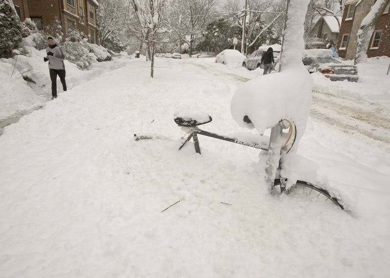
De eerste sneeuwstorm op komst voor de V.S.
Crushing, Cruising Snowstorm to Plaster Northeast Saturday
Crushing, Cruising Snowstorm to Plaster Northeast Saturday
quote:Up to a foot of heavy wet, back-breaking snow will plaster areas north and west of I-95 Saturday, causing massive power outages, downed trees and travel nightmares.
The storm will hit hard and fast, traveling from southwest to northeast over the mid-Atlantic and New England in less than 24 hours.
The heaviest snow from the storm will stretch from along the Virginia/West Virginia border through a large swath of central and eastern Pennsylvania to southeastern New York state, northwestern New Jersey, northern Connecticut, central and western Massachusetts to southern New Hampshire and southwestern Maine.
Cities that are likely to receive the heaviest snowfall include: Hartford, Conn., Frederick, Md., Worcester, Mass., Nashua, N.H., Netcong, N.J., Newburgh, N.Y., Allentown, Pa., Winchester, Va. and Martinsburg, W.Va.
In these areas and others over the interior Northeast, the snow will come down hard enough to accumulate on the roads making for slippery driving. The worst conditions will be in the hilly areas and the mountains, where slightly lower temperatures are in store.
Thousands of trees could come down, and over a million people could be without power. Some rural roads could be blocked for days by fallen trees. Driving or walking through wooded areas during and immediately following the storm could be dangerous.
Thunderstorms could accompany the snow, adding to the drama.
I-95
While the heaviest accumulation will miss the I-95 cities from Washington, D.C., and Baltimore to Philadelphia, New York, Providence and Boston, some wet snow will fall on the heart of the downtown areas and can cover rooftops, trees and grassy areas. Streets in the downtown areas of these cities will be mainly wet.
Because of the intensity of the rain and snow, with increasing winds, expect flight delays and cancellations in the Northeast and ripple-effect delays elsewhere throughout the nation.
New England
The storm will turn into a "Halloween Weekend Screamer" in New England. Not only will some communities be battling problems from heavy snow, but also dramatically increasing winds that will also down trees and wires.
Powerful northeasterly winds will cause coastal flooding along east- and northeast-facing shorelines of New England. For part of the region, this could be an Irene with snow.
The storm will bring a period of heavy rain and the potential of urban flooding along the coast of the mid-Atlantic and the immediate southern and eastern coasts of New England.
It's Not a Halloween Prank
Snowfall during October is not uncommon in the Northeast in general, but when it does occur it typically only falls on a very narrow swath, high elevations or a relatively small patch of land.
According to Expert Senior Meteorologist Henry Margusity, "During this storm, the extent of places that may receive 6 to 12 inches is unprecedented."
Unlike many storms which tend to underachieve, this one will overachieve and is likely to be a record-breaker.
It will catch many people off guard because of its intensity and fast-hitting nature.
@Accuweather


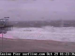
quote:Oliver Oeckerath bericht over de sneeuwsituatie in de VS: "In het noordoosten van de VS staat een tiental staten tussen West Virginia en Maine vanmiddag en in de nacht naar zondag een beruchte "nor`easter" te wachten: een lagedrukgebied dat langs de oostkust richting Nova Scotia koerst. Terwijl langs de lijn Washington-Boston voornamelijk regen of natte sneeuw wordt verwacht, transformeert de neerslag in het binnenland met een noordoostelijke aanvoer in droge sneeuw. Amerikaanse weerdeskundigen voorspellen dat op een voor eind oktober weergaloze schaal een pak van 15 tot 30 cm zal gaan vallen.
In de Appalachen is zelfs tot meer dan een halve meter sneeuw mogelijk met intensiteiten van lokaal 10 cm per uur. De Canadese weerdienst rekent vervolgens ook in het zuidwesten van de provincie New Brunswick op een laag van 15 à 20 cm. Er wordt veel overlast verwacht, omdat talloze bomen en hoogspanningsleidingen onder het gewicht van de papperige sneeuw zullen bezwijken".
@Jan Visser

Winterstorm in Noordoost-Amerika
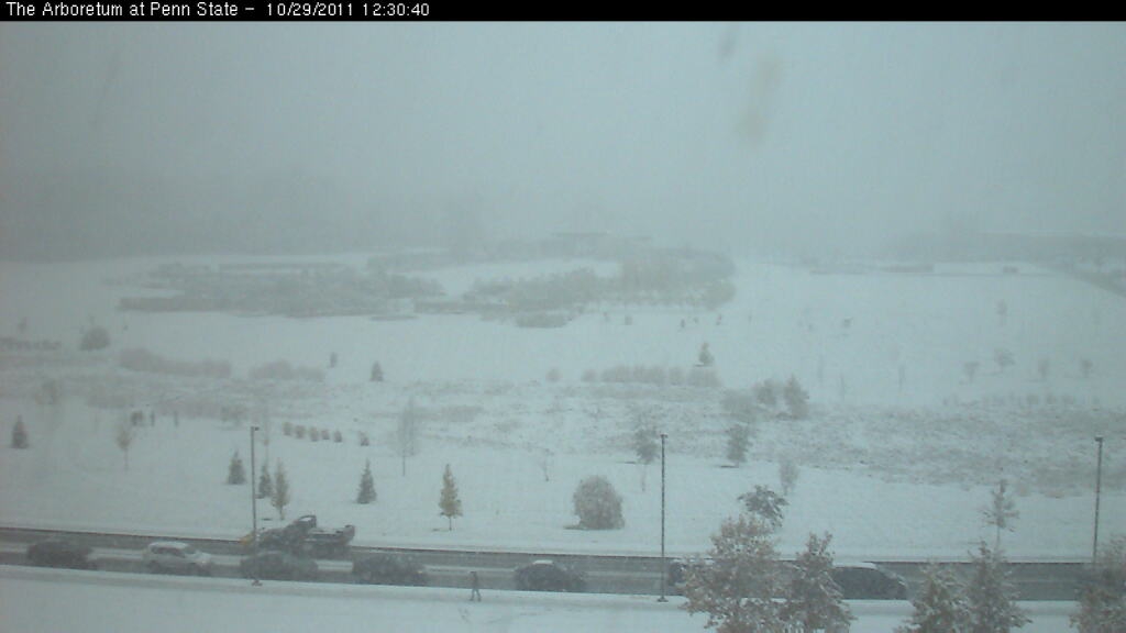
In Nederland is het momenteel erg zacht voor de tijd van het jaar; de middagtemperatuur ligt bij ons de komende dagen veelal tussen 14 en 18 graden. In het noordoosten van de Verenigde Staten wordt het steeds kouder en liggen de waarden de komende dagen veelal rond of ruim onder het vriespunt. Vanavond, Amerikaanse tijd, wordt er in diverse staten in het noordoosten record sneeuwval verwacht voor oktober.
Tussen een hogedrukgebied boven het oosten van Canada en een lagedrukgebied voor de noordoostkust van Amerika steekt de komende uren heel geleidelijk een stevige, maar ook erg koude noordoostenwind op. Hiermee wordt koude lucht vanuit het noorden van Canada naar onder andere de staten Maine, New York en Pennsylvania aangevoerd. De temperatuur daalt er in de loop van de avond (zaterdagavond plaatselijke tijd) tot richting het vriespunt, om vervolgens in de nachtelijke uurtjes tot ruim onder het vriespunt te dalen. De dagen daarna blijft de koude lucht hangen en komt het kwik nauwelijks nog boven nul uit.
Zware natte sneeuw
Tegelijkertijd schuift er met die koude lucht vanuit het noordoosten een storing, die hoort bij een snel uitdiepend lagedrukgebied dat voor de kust van North- en South-Carolina ligt, vanuit het zuiden over diezelfde staten. Deze brengt veel wind, maar dus ook flink wat nattigheid met zich mee en met temperaturen rond of net onder het vriespunt zal dit vrij snel over gaan in (natte) sneeuw. Amerikaanse weerdiensten spreken in de berichten ook van zware natte sneeuw.
Bomen nog vol in blad
Het is er op veel plaatsen nu namelijk nog rustig herfstweer en veel bomen zitten nog volop in het blad. Zodra de natte sneeuw, die relatief gezien behoorlijk zwaar is ten opzichte van ‘droge’ sneeuw, op de bladrijke bomen valt en de wind gaat aantrekken, zullen veel takken het snel begeven en afbreken. Men gaat er in sommige gebieden dan ook vanuit dat veel huishoudens het komende weekeinde zonder stroom komen te zitten.
Winter Storm Warning
De Amerikaanse weerdiensten verwachten voor komende avond en nacht op veel plaatsen ruim 20 tot 25 centimeter sneeuw. Mocht dit uitkomen dan is dat voor de maand oktober record veel. In diverse staten geldt vanaf vandaag dan ook een zogeheten ‘Winter Storm Warning’ vanuit de regering. Inwoners van deze gebieden wordt dan ook verzocht om de lokale berichten goed in de gaten te houden.
Zondag trekt de sneeuwstoring geleidelijk verder naar het noorden en komen de meer noordelijk gelegen steden en gebieden, waaronder Boston en Portland aan de beurt. Ook de waarschuwing verhuist dan mee naar het noordoosten. Zuidelijk daarvan bouwt zich een hogedrukgebied op. De kou blijft de dagen daarna echter nog wel boven het noordoosten van de Verenigde Staten hangen en het sneeuwdek zal dan ook nog een tijdje blijven liggen.
Bronnen: Meteo Consult, NOAA, Weather Channel.

Heerlijk. 1 graden in New York. 
Ook mooie beelden op cams te zien nu in Connecticut met matige sneeuw die lekker blijft liggen ook.
Heerlijk.
Ook mooie beelden op cams te zien nu in Connecticut met matige sneeuw die lekker blijft liggen ook.
Heerlijk.
3 doden door het winterweer in de V.S.
Vroege sneeuwstorm in Noordoost-VS
In het noordoosten van de Verenigde Staten zitten ruim twee miljoen huishoudens zonder stroom. Het gebied wordt geteisterd door een zeldzaam vroege sneeuwstorm.
In sommige gebieden van de staten New Jersey en Massachusetts is zo'n 40 centimeter sneeuw gevallen. New Jersey en Connecticut hebben de noodtoestand uitgeroepen en ook mensen in Maryland en Pennsylvania kampen met het vroege winterweer.
Slachtoffers
Zeker drie mensen zijn omgekomen door ongelukken die met de sneeuw te maken hebben. Veel bomen hebben nog blad en bezwijken onder de last van de sneeuw. In hun val nemen ze stroomkabels mee, waardoor de elektriciteit is uitgevallen.
Een 20-jarige man uit Massachusetts werd geëlektrocuteerd toen hij uit zijn auto stapte en een geknapte stroomkabel raakte. In Pennsylvania stierf een 84-jarige man doordat een boom op zijn huis viel. De derde dode viel in het verkeer, in Connecticut.
In Massachusetts moesten vijf amateurvoetballers met onderkoelingsverschijnselen worden opgenomen in een ziekenhuis. Ondanks de kou was hun wedstrijd niet afgelast.
Oud record gebroken
Door het winterweer zijn een aantal luchthavens in het noordoosten van Amerika gesloten en zijn zeker duizend vluchten geschrapt.
Op sommige plaatsen wordt 30 centimeter sneeuw verwacht. Dat zou een record zijn voor deze tijd van het jaar. In Central Park in New York ligt meer dan 2 centimeter sneeuw, wat sinds 1925 niet meer is voorgekomen.
Het pak sneeuw in de miljoenenstad zal dit weekeinde ongeveer 10 centimeter dik worden en dat is meer dan tijdens het vorige record dat stamt uit oktober 1869.
nos


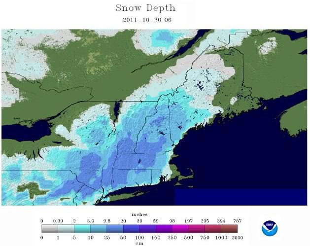
50-70 cm sneeuw inmiddels gemeten op sommige plekken 
“Rather than love, than money, than fame, give me truth.”
quote:8 dead after freak winterstorm
More than 3.2m homes and businesses across the north-east US have been left without power after a freak snowstorm killed at least eight people and disrupted transport across the region.
From Maryland to Maine, officials said it would take days to restore electricity, even though the snow ended Sunday.
The storm smashed record snowfall totals for October and worsened as it moved north. Communities in western Massachusetts were among the hardest hit. Snowfall totals topped 68.6cm (27in) in Plainfield, and 66cm nearby Windsor.
The storm was blamed for at least six deaths, and states of emergency were declared in New Jersey, Connecticut, Massachusetts and parts of New York.
Roads and railways were blocked and flights cancelled, with passengers on a JetBlue flight stuck on a plane in Hartford, Connecticut, for more than seven hours on Saturday.
More than 800,000 customers were without electricity in Connecticut alone – shattering the record set in August by Hurricane Irene. Massachusetts and New Jersey each suffered more than 600,000 power cuts. Parts of Pennsylvania, New Hampshire, New York, Maine, Maryland and Vermont also were without power.
"It's going to be a more difficult situation than we experienced in Irene," Connecticut Governor Dannel Malloy said. "We are expecting extensive and long-term power outages."
Thirty-two shelters were open around the state, and Malloy asked volunteer fire departments to allow people in for warmth and showers. At least four hospitals were relying on generators for power.
Around Newtown in western Connecticut, trees were so laden with snow on some back roads that the branches touched the street. Every few minutes, a snap filled the air as one broke and tumbled down. Roads that were plowed became impassible because the trees were falling so fast.
The National Weather Service said the snowstorm "absolutely crushed previous records that in some cases dated back more than 100 years". Saturday was only the fourth snowy October day in New York's Central Park since record-keeping began 135 years ago.
There usually is not enough cold air in the region to support a snowstorm this time of year, but an area of high pressure over south-eastern Canada funneled cold air south into the US, the service said. That cold air combined with moisture coming from the North Carolina coast to produce the unseasonable weather.
The JetBlue passengers stranded at Hartford's Bradley International Airport were on a flight from Fort Lauderdale, Florida, to Newark, New Jersey, that had been diverted. Passenger Andrew Carter, a football reporter for the Sun Sentinel in Fort Lauderdale, said the plane ran out of snacks and bottled water, and the toilets backed up.
JetBlue said power outages at the airport has made it difficult to get passengers off the plane, and added that the passengers would be reimbursed.
There were other flight delays in the region over the weekend, and commuter trains in Connecticut and New York were delayed or suspended because of downed trees and signal problems. Amtrak suspended passenger train service on several north-eastern routes, and one train from Chicago to Boston got stuck overnight in Palmer, Massachusetts. The 48 passengers had food and heat, a spokeswoman said, and they were taken by bus Sunday to their destinations.
In south-eastern Pennsylvania, an 84-year-old man was killed when a snow-laden tree fell on his home. In Connecticut, the governor said one person died in a traffic accident that he blamed on slippery conditions.
A 20-year-old man in Springfield, Massachusetts, stopped when he saw police and firefighters examining downed wires and stepped in the wrong place and was electrocuted.
The snow was a bone-chilling slush in New York City, and was a taste of what's to come for demonstrators camping out at Zuccotti Park in lower Manhattan for the Occupy Wall Street protest.
Nick Lemmin, of Brooklyn, spent his first night at Zuccotti in a sleeping bag in a tent, wearing thermals, a sweatshirt and a scarf.
"I slept actually pretty well," he said. "It was pretty quiet."
quote:Northeast Snow From Space
The white colored areas highlighted by the yellow oval on the image below is snow cover over the Northeast as viewed from space. The white shaded areas on the upper right and lower left of this image are clouds. This image was taken on Sunday after the historic storm departed.

Nog bijna 2 miljoen zonder stroom in VS
In vijf staten in het noordoosten van de Verenigde Staten zaten maandag nog steeds 1,8 miljoen mensen zonder stroom. De uitval werd veroorzaakt door een hevige sneeuwstorm. Dat meldde nieuwszender CNN. Het kan tot vrijdag duren voordat de elektriciteit overal weer is hersteld.
Door de zeldzaam vroege sneeuwval zijn in totaal 12 doden gevallen. Het spoor- en vliegverkeer is inmiddels weer op gang gekomen. Maar voor benzinestations staan lange rijen omdat door de stroomuitval veel pompen dicht zijn. In veel plaatsen is het jaarlijkse Halloweenfeest afgelast of uitgesteld.
bron
[ Bericht 0% gewijzigd door #ANONIEM op 31-10-2011 22:40:52 ]
quote:Nog altijd geen stroom in delen VS
WAYLAND - Honderdduizenden mensen in het noordoosten van de Verenigde Staten hebben al dagen geen elektriciteit vanwege de ongebruikelijk vroege en zware sneeuwstorm die het afgelopen weekeinde over het gebied trok.
Er zijn inmiddels minstens 21 mensen door toedoen van het winterse weer om het leven gekomen. De meeste slachtoffers vielen door omvallende bomen, bij verkeersongelukken of werden geëlektrocuteerd door kapotte elektriciteitskabels.
Op het hoogtepunt van de storm zaten zeker 3,1 miljoen huishoudens zonder stroom. Maandagavond waren dat nog 2,2 miljoen. De gouverneur van de staat New Jersey zei dat donderdag de elektriciteitsvoorziening weer hersteld zal zijn voor 95 procent van de 375 duizend huishoudens die in New Jersey nu nog zonder stroom zitten.
Zware sneeuw
De combinatie van zware, natte sneeuw, bomen met nog veel bladeren en een harde wind zorgde ervoor dat op veel plaatsen takken en elektriciteitskabels naar beneden kwamen en bomen omwaaiden. Op sommige plekken viel in het weekeinde een kleine zeventig centimeter sneeuw. In het plaatsje Peru, in de staat Massachusetts, viel 81 centimeter sneeuw. Honderden scholen bleven maandag dicht.
Voor veel steden is de sneeuwstorm een harde financiële klap na de schade die veel steden opliepen door de orkaan Irene
http://www.accuweather.co(...)r-deja-vu-snowst.aspquote:The following photos were taken by AccuWeather.com Meteorologist Heather Buchman in the Denver Tech Center area, just south of the city, during the Nov. 1-2, 2011 snowstorm.
This snowstorm comes exactly one week after Denver's first significant snow of the season.
Let it snow...let it snow...
Gaan er (koude)records gebroken worden in delen van Alaska en Canada?
De tempreaturen gaan richting de -40.
[ Bericht 0% gewijzigd door #ANONIEM op 14-11-2011 22:08:46 ]
De tempreaturen gaan richting de -40.
quote:Record-Challenging Cold Building in Alaska, Canada
Unusually cold air is forecast across Interior Alaska and northwestern Canada this week. While cold air is common here, record lows might be broken by the end of the week.
The weather pattern will set up such that high pressure will strengthen across Interior Alaska and Canada's Yukon Territory over the next several days. Usually high pressure building means nice weather. But, not this time.
Skies will be clear for several days thanks to the high pressure. Now that the days are very short, clear skies result in temperatures cooling steadily both day and night.
Temperatures will become colder and colder over the next several days. The coldest of the air is expected Wednesday into Thursday, when temperatures should dip to between 30 and 40 below zero.
For example, the record low is Fairbanks is 41 below zero Wednesday, and 39 below zero Thursday. These records will be very close to being broken.
Even high temperatures will be well below zero.
A storm is expected to dislodge this cold air southward into the U.S., possibly leading to the first snow of the season in Seattle Friday.
[ Bericht 0% gewijzigd door #ANONIEM op 14-11-2011 22:08:46 ]

Wat ik nou niet begrijp is waarom een land aan de ene kant bol staat van de technologie en anderzijds zo amateuristisch handelt inzake hun netwerk of wegennet want het is elk jaar hetzelfde dat miljoenen yanks geen stroom oid hebben vanwege het weer.quote:Op maandag 31 oktober 2011 22:40 schreef aloa het volgende:
Nog bijna 2 miljoen zonder stroom in VS
In vijf staten in het noordoosten van de Verenigde Staten zaten maandag nog steeds 1,8 miljoen mensen zonder stroom. De uitval werd veroorzaakt door een hevige sneeuwstorm. Dat meldde nieuwszender CNN. Het kan tot vrijdag duren voordat de elektriciteit overal weer is hersteld.
Door de zeldzaam vroege sneeuwval zijn in totaal 12 doden gevallen. Het spoor- en vliegverkeer is inmiddels weer op gang gekomen. Maar voor benzinestations staan lange rijen omdat door de stroomuitval veel pompen dicht zijn. In veel plaatsen is het jaarlijkse Halloweenfeest afgelast of uitgesteld.
bron
Yvonne schreef op maandag 31 oktober 2011 @
13:59:43 in DEF SC #282 aan AchJa & Co
Vanaf hier en nu stopt het in DEF én op FOK!
Ik wil hier een normale SC zonder gebitch!
13:59:43 in DEF SC #282 aan AchJa & Co
Vanaf hier en nu stopt het in DEF én op FOK!
Ik wil hier een normale SC zonder gebitch!
Ze hebben wel vaak van die slappe paaltjes met stroomdraden of niet?
Het is nog ver weg maar waarschijnlijk in 2013 naar Canada toe voor een 6-8 weken kan er overigens nu al zin in hebben
Het is nog ver weg maar waarschijnlijk in 2013 naar Canada toe voor een 6-8 weken
Never Stop Exploring!
Life begins at the end of your comfort zone!
Follow me on Twitter: https://twitter.com/EdwinKr83 Instagram: https://www.instagram.com/edwinkr83/
Life begins at the end of your comfort zone!
Follow me on Twitter: https://twitter.com/EdwinKr83 Instagram: https://www.instagram.com/edwinkr83/
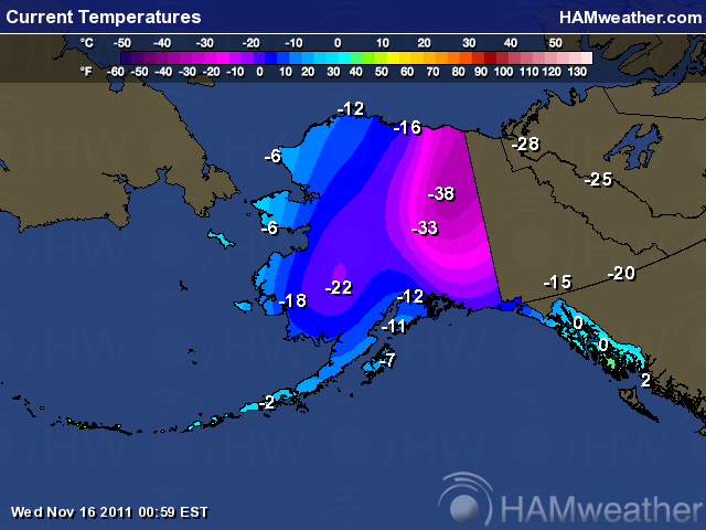
Canada ook -40quote:Op woensdag 16 november 2011 18:31 schreef pfaf het volgende:
Het plaatje in de OP geeft nu -41 voor Alaska.
Brrrrr
Ohhh, bij mn zus is het nog 10C maar hebben al wel een tijdje terug de 1e sneeuw gehad 
Ik kan het je wel uitleggen maar het niet voor je begrijpen........
Never Stop Exploring!
Life begins at the end of your comfort zone!
Follow me on Twitter: https://twitter.com/EdwinKr83 Instagram: https://www.instagram.com/edwinkr83/
Life begins at the end of your comfort zone!
Follow me on Twitter: https://twitter.com/EdwinKr83 Instagram: https://www.instagram.com/edwinkr83/
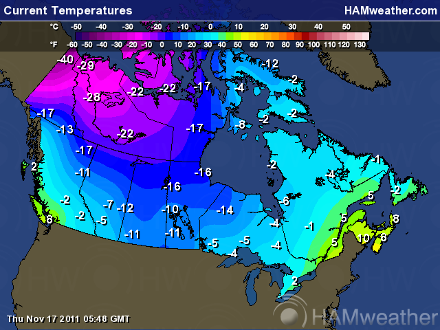
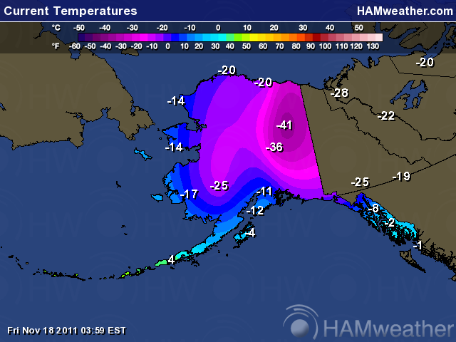
Unimaginable Cold Remains Locked In Across Alaska
A record-breaking cold snap gripping Alaska will persist through at least the Thanksgiving holiday, delivering temperatures that most of the world would consider hard to fathom.
Near the center of this deep freeze since Tuesday is Fairbanks, the state's second largest city situated across the interior with a population of 31,000.
Temperatures dropped to an incredible 41 degrees below zero Thursday morning, breaking the old record of 39 below.
Six hours of sunlight did little to warm temperatures during the daytime hours, with the mercury topping off at a crispy 30 below.
Though extreme temperature swings are the norm for the Last Frontier, normal temperature are about 40 degrees higher this time of year (about 10 above for a daytime high and 10 below for a nighttime low).
Some outlying valley areas bested Fairbanks. According to the local National Weather Service office, Manley Hot Springs, located about 85 miles to the west, bottomed out at 54 below zero.
Such a temperature would establish a new all-time record low in all but nine states. However, it remains 26 degrees off Alaska's all-time record of 80 below set on Jan. 23, 1971, in Prospect Creek.
As Senior Meteorologist Dave Samuhel indicated, the unusually cold air is thanks to a strengthening area of high pressure. Samuhel also notes that nearby northwestern Canada is also locked in the grips of this cold wave.
The good news for hearty Alaskans is that milder air is beginning to work its way in. However, the bad news is that we must put the word 'milder' in its appropriate context.
High temperatures the next several days in Fairbanks will be about 10 to 15 degrees higher -- in the middle teens below zero. Indications are that the mercury will stay below zero until after the Thanksgiving holiday across a large part of the interior.
Looking for "warmth"? Head closer to the Alaskan-Pacific coast, where cities like Anchorage will reach a sweltering 15 degrees into the weekend.
@Accuweather
NIMMER ZO KOUD IN NOVEMBER IN DE CANADESE STAD EDMONTON. VEEL REGEN (ALWEER!) IN SPANJE.
door Jan Visser
Het is HARTJE WINTER in delen van Canada. Oliver Oeckerath bericht: "De grote steden op de Canadese prairies hebben een weekend in de diepvrieskast achter de rug. Zaterdag noteerde Calgary, Alberta, in de ingestroomde Arctische luchtmassa`s een maximumtemperatuur van -16,3° tegen +1° normaal en op de internationale luchthaven van Edmonton bleef het kwik steken op -18,7°. Regina, de hoofdstad van Saskatchewan, moest eergisteren genoegen nemen met -17,9° (normaal: -3°). Saskatoon meldde zaterdag -16,4° en gistermiddag -16,8°. De absolute topper was echter Coronation (52° NB), waar het eergisteren 'from dawn till dusk' niet warmer werd dan -20,3°. In de nacht naar zondag mat Edmonton International Airport boven een sneeuwdek van 14 cm zowaar -36,1°, waardoor het op 20 november 1963 gevestigde maandrecord van -35,6° nog wat scherper werd gesteld. De gevoelstemperatuur bedroeg maar liefst -45°! Gistermiddag wees de thermometer daar maximaal -18,8° aan, terwijl in Calgary al zachtere lucht binnensijpelde bij -3,4°. De laagste etmaaltemperatuur bedroeg in Hendrickson Creek in Alberta (25 cm sneeuw) achtereenvolgens -35,3 en -33,2°".
bron
Wij gaan 1 december richting de VS (NYC --> Bosten--> niagara falls via Canada naar Detroit met als eind punt Chicago) wat kan ik verwachten de komende weken?
Sorry voor de evt. spelfouten maar ik heb een lichte vorm van dyslectie
Die meren daar tussen de VS en Canada staan bekend als veroorzaker van ladingen sneeuw. Vooral in het begin van de winter als die meren nog niet dichtgevroren zijn.quote:Op donderdag 24 november 2011 19:47 schreef daanski82 het volgende:
Wij gaan 1 december richting de VS (NYC --> Bosten--> niagara falls via Canada naar Detroit met als eind punt Chicago) wat kan ik verwachten de komende weken?
Het lijkt er op dat het de komende week rustig blijftquote:
[..]
Die meren daar tussen de VS en Canada staan bekend als veroorzaker van ladingen sneeuw. Vooral in het begin van de winter als die meren nog niet dichtgevroren zijn.
Sorry voor de evt. spelfouten maar ik heb een lichte vorm van dyslectie
quote:Op zondag 27 november 2011 09:41 schreef daanski82 het volgende:
[..]
Het lijkt er op dat het de komende week rustig blijft
quote:Great Lakes Snow May Close Out November
AccuWeather.com meteorologists will soon determine exactly how much snow will blanket the above area.
The season's first significant and disruptive snowfall may be on the way for the central Great Lakes before November comes to a close.
After being bypassed by the substantial snow that blanketed northeastern Minnesota this weekend, the central Great Lakes will likely become the bullseye for snow Tuesday night into Wednesday.
Cities that may soon turn into a winter wonderland include Detroit, Mich., Toledo, Ohio, and Fort Wayne, Ind., all of which have yet to receive significant snow since last winter.
Initially, another round of rain will spread across the central Great Lakes Monday night into Tuesday as a moisture-loaded storm arrives from the South. Once a cold front from Canada enters into the picture, a changeover to snow will take place.
The storm will also be responsible for pushing soaking rain through the East Coast and allowing wet snowflakes to fly across the Tennessee Valley.
Snowflakes will do more than make an appearance across the central Great Lakes. The impending snow event will likely be a disruptive one for residents and visitors.
AccuWeather.com meteorologists are now forecasting an accumulation of at least a few inches from northern Indiana and northwestern Ohio north across lower Michigan and into southwestern Canada.
Depending on the amount of cold air that wraps into the storm, accumulations may approach or even exceed a half a foot in a few locations.
Airline passengers should prepare for flight delays, while motorists will be faced with slick and treacherous roadways.
The snow should be heavy and wet in nature, potentially weighing down tree branches and wires. Power outages could become an issue.
Be sure to check back with AccuWeather.com for updates as we work on refining our snowfall predictions for this storm.


Ik had dat ook gelezen nadat ik mijn berichtje had geplaatst (bloos). Maargoed, komende zondag krijgen we de auto en tegen dinsdag zijn we bij de great lakes :-)quote:
Sorry voor de evt. spelfouten maar ik heb een lichte vorm van dyslectie
quote:"Once-a-decade"-event unfolds for Southern California
All the ingredients are coming together for a severe Santa Ana wind event to unfold across Southern California tonight into Thursday with other Southwest communities also facing potentially damaging winds.
"A once a decade type wind storm," is how AccuWeather.com Western Expert Meteorologist Ken Clark is describing the impending Santa Ana winds.
The populated Santa Ana wind-prone areas will endure gusts to 70 mph, while gusts on the neighboring mountaintops could reach 90 mph.
The strongest winds will howl late tonight into Thursday morning.
"Winds of this magnitude will cause damage [to trees and structures] and widespread travel and power disruptions," warned Clark.
"High-profile vehicles will be forced to not travel and even traveling in cars in the windy areas will be dangerous."
The fact that powerful crosswinds can easily overturn semi-trucks and campers and severely tug on smaller vehicles prompted the latter statement.
Bodily harm may not only result from falling trees and branches, but also as loose lawn items and Christmas decorations get tossed around and turn into what Clark describes as "airborne missiles."
Despite declaring that this will be a "cool Santa Ana event," AccuWeather.com Expert Senior Meteorologist Alex Sosnowski cautions that the wildfire danger should not be taken lightly.
"Dry air often accompanies Santa Ana events and makes the fuel, such as dry brush, more ready to burn. Any fires that get started and are not extinguished quickly could be whipped into a frenzy by the strong winds."
It is not just Southern California bracing for potentially damaging winds. San Francisco, Las Vegas, Salt Lake City and other locations from Utah to California and far western Arizona will also be threatened.
The fierce winds will develop from north to south across the Southwest today into tonight, then will continue to howl into Thursday.
In addition to damage concerns, the winds could lead to flight delays. Motorists traveling through the deserts could also be faced with blowing dust dramatically reducing visibility.
There are two advantages to this wind event--dense fog will finally clear the San Joaquin Valley today and the same storm kicking up the wind will bring welcome snow to the ski resorts of the Four Corners region tonight into Friday.
Friday is also when the wind event throughout the Southwest will ease, but yet another (though likely not as strong) may follow this weekend.
In de VS verwacht men tot meer dan 30 cm sneeuw rond de grote meren in het noorden.
Het zogenaamde Lake effect
Het zogenaamde Lake effect

Het sneeuwt al aardig aan de westkust van Michigan maar er blijft nog niets liggen.
Patience is not one of my virtues, neither is memory. Or patience for that matter.

Possible Blizzard for Already Snowed-In Alaskans

Serious cold, ice and snow in Alaska is causing some unusual problems in a place known by people in the continental United States for being a snow haven.
The town of Valdez got 66.9 inches of snow between Jan. 1 and 9. That's 99 percent of the town's normal snowfall for the whole month of January. The greatest snow depth was close to 7 feet of snow on Jan. 8. The town has received 18 feet of snow since Dec. 1.
The National Guard headed to Cordova, a fishing town in southeastern Alaska, to dig people out from massive snowfall. Last Friday, snow was as deep as 59 inches or close to 5 feet. The snow depth shrunk to a "meager" 45 inches after a major storm rained on it Saturday and Sunday. The rain falling on top of the snow added to the weight. The heavy, compacted snow stressed roofs, which caused some roof collapses.
Such deep snow is unusual this early in the season and so close to the coast. Despite Alaska's reputation as a snowy place, big storms that hit in the populated areas near the coast usually dump rain, not snow. The mildly warmer temperatures near the coast comes from the warming effect of the ocean.
What's next? More snow. . . A lot of it.
Starting Tuesday, a storm will push along the southern coast of Alaska with heavy snow and very high winds. Valdez, already buried under many feet of snow, could get another 1 to 2 feet of snow through Wednesday, with winds gusting up to 60 mph on the nearby coast. The heavy snow coupled with the wind could cause structural damage to buildings in Valdez. The drifting snow can distribute weight unevenly, putting more stress on roofs, especially flat ones.
The storm will change from snow to rain at the coast. In Cordova, it will snow through Tuesday night, with a mix of rain and snow on Wednesday.


Ook in delen van Alaska deze winter geen gebrek aan sneeuw. Oliver Oeckerath kwam met het volgende opzienbarende sneeuwbericht: “Het district Valdez-Cordova, gelegen in het zuidoosten van Alaska aan de Prince William Sound, is de afgelopen drie weken geteisterd door uitzonderlijk zware sneeuwval met hoeveelheden tot maar liefst 5,50 meter! In het stadje Cordova zijn al drie huizen onder het gewicht van de papperige sneeuw bezweken en is door burgemeester Jim Kallander de noodtoestand uitgeroepen. Sinds zondag (8 januari) zijn 70 leden van de Alaska National Guard in actie om Cordova te bevrijden van de enorme sneeuwduinen met een hoogte van 3,70 tot 4,30 meter (12-14 voet). In Valdez is deze winter reeds 7 meter sneeuw gevallen. Het record staat op naam van het seizoen 1989/90 met een totaal van 560,7 inches (14,24 meter)”.
@Jan Visser
@Jan Visser
De tijd dringt, het einde nadert. De dagen tikken weg.
En dan... verschijnt hij.
Hij kijkt je recht aan en lacht.
Die lach is het laatste wat je hoort.
En dan... verschijnt hij.
Hij kijkt je recht aan en lacht.
Die lach is het laatste wat je hoort.

quote:Ingredients on Deck for Historic Seattle Snowstorm
An arctic cold front slicing south across the Northwest will usher in the latest round of arctic chill into the country. The cold air will support snow in the region over the next several days before a major storm could wallop the region by the middle of next week.
Arctic air will slice into the Northwest into early next week. The cold air pouring south will set the stage for a potentially historic snowstorm in the Seattle area.
Initially, intermittent snow will fall across Washington and Oregon and areas farther east across the Interior West through Tuesday.
Snow can accumulate a couple of inches from Seattle, Wash., to Portland, Ore., through Monday.
Despite the occasional snow early this week, our attention will be focused on the region for some wild weather next week.
A powerhouse storm will slam into the Northwest later Tuesday night into Wednesday, sending a surge of heavy rain and snow into the Pacific Northwest.
"Snow, perhaps a serious snowfall, is likely somewhere in western Washington. Whether it is in north of Seattle to Bellingham or in and even south of Seattle will be determined by where the storm moves ashore and how much the cold air wants to hold on, said Expert Senior Meteorologist and Western Expert Ken Clark.
"Single day snowfall of six inches or greater has occurred on only 15 days since 1950, none since 1996," said Climatologist Jim Rourke.
"The top Seattle snowstorm was Feb. 1, 1916 when 21.5 inches piled up," added Rourke.
The greater Seattle area has the potential to pick up over a foot of snow, with the majority falling Tuesday night into Wednesday should all the ingredients fall into place.
Despite the risk for a historic snowstorm early next week, the most serious concern follows for the late-week period. Major flooding and mudslides could result late next week as a series of warmer, moisture-laden storms pound the region.
"Despite the exact outcome of the snow in the middle of the week, a parade of warmer storms late next week that follow will deliver heavy rain, putting the Seattle area at risk for major flooding," said Senior Meteorologist Kristina Pydnowski.
Thus, residents across the Pacific Northwest are urged to prepare for the wild weather set to hit the region next week. Stay tuned to AccuWeather.com for the latest information on what to expect.
Mogelijk zwaarste sneeuwval sinds 1940 voor de Seattle areaquote:Twin winter storms slams Northwest
Seattle could see one of its largest snowfalls since the 1940s as twin winter storms move over the Pacific Northwest, according to the National Weather Service.
Between 5 and 10 inches of snow could hit the Seattle-Tacoma area Wednesday, said Dustin Guy, a meteorologist at the weather service's Seattle office.
Precipitation moving in from the south and west is combining with cold air moving south from Canada to create the heavy snowfall, Guy said. If snowfall amounts top 7 inches, the winter weather event will rank among Seattle's 10 worst since the early 1940s, Guy said.
High-wind warnings were in effect along the coast, where winds could gust to hurricane force -- knocking down trees and causing power outages, said CNN meteorologist Taylor Ward.
Wednesday's snowfall in Seattle may equal its annual average, Ward said.
Mountainous areas of the Pacific Northwest will see even more snow, with the largest accumulations on the eastern slopes of the Cascades, according to the weather service. Significant snowfall is expected across southern Washington, northwest Oregon and into western Idaho. Portland could see about 3 inches, according to Ward.
From late Tuesday through early Thursday, 2 feet to 3.5 feet of snow is forecast for the mountains east of Seattle, Guy said. Mount Rainier could see 10 feet of snow by Friday.
The first storm moved into the area Monday and Tuesday. The second and stronger storm was forecast to hit Wednesday into Thursday.
"It's pretty big when you get back-to-back storms like that," weather service meteorologist Roger Cloutier said.
Scattered areas near Easton, Washington, along Interstate 90 in the Cascade Mountains 55 miles east of Seattle, have already received 32 inches of snow, Cloutier said.
The snowfall extends south into Oregon, with as much as 18 inches forecast for the Bend area. CNN affiliate KTVZ in Bend said an earlier round of snow over the weekend gave a boost to local ski resorts but also created treacherous driving conditions that left at least one motorist dead.
Those conditions were expected to worsen. Winter storm warnings were in effect across the region.
"Expect extreme travel difficulties to develop on Wednesday," the weather service said, advising those who must take to the roads during the storm to carry a flashlight, blankets and extra food and water.
The Washington State Department of Transportation said 1,250 workers will use nearly 500 pieces of equipment statewide to treat and plow roadways.
CNN affiliate KING reported that Seattle Public Schools opted to close all schools two hours early.
The heavy snowfall will be followed by rain, which could produce ponding water and urban flooding, Guy said.
"It's just gonna be a mess all around," he said of the coming few days in the Seattle area.
Cloutier said even though computer models are trending colder and colder for the coming days, the heavy snow will eventually pose a flooding threat.
"When the snow does finally melt, you can almost guarantee there will be some flooding somewhere," he said.
Verdorie kregen wij zulk soort berichten maar.. 
“Rather than love, than money, than fame, give me truth.”
Het is inmiddels flink aan het sneeuwen in en rond Seattle

quote:Schools are closed and a nightmare awaits commuters in Seattle today with a storm dumping a winter's worth of snow in less than 24 hours.
Snow that began whitening Portland late on Tuesday evening spent the overnight hours spreading northward along Interstate 5 to Seattle.
While the snow will transition to soaking rain soon after sunrise in Portland, the same will not happen in Seattle.

Waarschuwing voor extreme kou in het noorden van de V.S.

quote:...EXTREME COLD WARNING IN EFFECT FOR NORTHERN AND CENTRAL NORTH
DAKOTA THROUGH NOON THURSDAY...
...EXTREME COLD WARNING IN EFFECT FOR SOUTHERN NORTH DAKOTA FROM
WEDNESDAY AFTERNOON THROUGH NOON THURSDAY.
.AN ARCTIC AIR MASS WILL CONTINUE TO PLUNGE FROM NORTHERN NORTH
DAKOTA INTO CENTRAL AND SOUTHERN NORTH DAKOTA WEDNESDAY MORNING.
FALLING TEMPERATURES WEDNESDAY MORNING WILL RESULT IN READINGS
RANGING FROM 5 BELOW ZERO TO 15 BELOW ZERO BY WEDNESDAY AFTERNOON.
WITH BRISK NORTHWEST WINDS OF 15 TO 30 MPH...WIND CHILL TEMPERATURES
WILL REACH 30 BELOW TO 45 BELOW ZERO.
THUS AN EXTREME COLD WARNING HAS BEEN ISSUED FOR ALL OF WESTERN
AND CENTRAL NORTH DAKOTA TO REFLECT THE DANGEROUSLY COLD
CONDITIONS THROUGH THURSDAY MORNING.
THOSE WORKING OUTSIDE PREPARE NOW FOR THE FRIGID TEMPERATURES AND
DANGEROUS WIND CHILLS AS FROSTBITE CAN OCCUR WITHIN MINUTES. IF
YOU ARE STRANDED DO NOT LEAVE THE RELATIVE SAFETY OF YOUR VEHICLE
AND CARRY A WINTER SURVIVAL KIT.
NDZ001>005-009>013-017-181945-
/O.CON.KBIS.EC.W.0001.000000T0000Z-120119T1800Z/
DIVIDE-BURKE-RENVILLE-BOTTINEAU-ROLETTE-WILLIAMS-MOUNTRAIL-WARD-
MCHENRY-PIERCE-MCKENZIE-
INCLUDING THE CITIES OF...CROSBY...BOWBELLS...MOHALL...
BOTTINEAU...ROLLA...WILLISTON...NEW TOWN...MINOT...TOWNER...
RUGBY...WATFORD CITY
540 AM CST WED JAN 18 2012
...EXTREME COLD WARNING REMAINS IN EFFECT UNTIL NOON CST THURSDAY...
* SUB ZERO TEMPERATURES WILL CONTINUE THROUGH THURSDAY MORNING.
BRISK NORTHWEST WINDS TO 25 MPH WILL CREATE WIND CHILL
TEMPERATURES BETWEEN 30 BELOW AND 45 BELOW ZERO.
* FROSTBITE CAN OCCUR WITHIN MINUTES.
* TEMPERATURE...WIND CHILL 30 TO 45 BELOW ZERO.
* IMPACTS...HYPOTHERMIA CAN OCCUR IF NOT PROPERLY PROTECTED.
PRECAUTIONARY/PREPAREDNESS ACTIONS...
AN EXTREME COLD WARNING MEANS THAT DANGEROUSLY COLD CONDITIONS
ARE EXPECTED TO OCCUR OR ARE OCCURRING. IF NOT PROPERLY
PROTECTED...YOU ARE LIKELY TO EXPERIENCE FROSTBITE AND
HYPOTHERMIA WHEN EXPOSED TO THESE CONDITIONS. IF YOU MUST BE
OUTSIDE...DRESS IN LAYERS OF LOOSE FITTING CLOTHES...WEAR A HAT
AND GLOVES OR MITTENS...AND COVER YOUR FACE. KEEP PETS INSIDE.
&&
$$
URGENT - WEATHER MESSAGE
NATIONAL WEATHER SERVICE BISMARCK ND
540 AM CST WED JAN 18 2012
...EXTREME COLD WARNING IN EFFECT FOR NORTHERN AND CENTRAL NORTH
DAKOTA THROUGH NOON THURSDAY...
...EXTREME COLD WARNING IN EFFECT FOR SOUTHERN NORTH DAKOTA FROM
WEDNESDAY AFTERNOON THROUGH NOON THURSDAY.
.AN ARCTIC AIR MASS WILL CONTINUE TO PLUNGE FROM NORTHERN NORTH
DAKOTA INTO CENTRAL AND SOUTHERN NORTH DAKOTA WEDNESDAY MORNING.
FALLING TEMPERATURES WEDNESDAY MORNING WILL RESULT IN READINGS
RANGING FROM 5 BELOW ZERO TO 15 BELOW ZERO BY WEDNESDAY AFTERNOON.
WITH BRISK NORTHWEST WINDS OF 15 TO 30 MPH...WIND CHILL TEMPERATURES
WILL REACH 30 BELOW TO 45 BELOW ZERO.
THUS AN EXTREME COLD WARNING HAS BEEN ISSUED FOR ALL OF WESTERN
AND CENTRAL NORTH DAKOTA TO REFLECT THE DANGEROUSLY COLD
CONDITIONS THROUGH THURSDAY MORNING.
THOSE WORKING OUTSIDE PREPARE NOW FOR THE FRIGID TEMPERATURES AND
DANGEROUS WIND CHILLS AS FROSTBITE CAN OCCUR WITHIN MINUTES. IF
YOU ARE STRANDED DO NOT LEAVE THE RELATIVE SAFETY OF YOUR VEHICLE
AND CARRY A WINTER SURVIVAL KIT.
NDZ018>023-025-031>037-181945-
/O.CON.KBIS.EC.W.0001.120118T1200Z-120119T1800Z/
DUNN-MERCER-OLIVER-MCLEAN-SHERIDAN-WELLS-FOSTER-GOLDEN VALLEY-
BILLINGS-STARK-MORTON-BURLEIGH-KIDDER-STUTSMAN-
INCLUDING THE CITIES OF...KILLDEER...BEULAH...HAZEN...CENTER...
GARRISON...MCCLUSKY...HARVEY...CARRINGTON...BEACH...MEDORA...
DICKINSON...MANDAN...BISMARCK...STEELE...JAMESTOWN
540 AM CST WED JAN 18 2012 /440 AM MST WED JAN 18 2012/
...EXTREME COLD WARNING REMAINS IN EFFECT UNTIL NOON CST /11 AM
MST/ THURSDAY...
* TEMPERATURES WILL FALL TO SUB ZERO READINGS WEDNESDAY MORNING.
BRISK NORTHWEST WINDS TO 25 MPH WILL CREATE WIND CHILL
TEMPERATURES BETWEEN 30 BELOW AND 45 BELOW ZERO.
* FROSTBITE CAN OCCUR WITHIN MINUTES.
* TEMPERATURE...WIND CHILL 30 TO 45 BELOW ZERO.
* IMPACTS...HYPOTHERMIA IS POSSIBLE IF NOT PROPERLY PROTECTED.
PRECAUTIONARY/PREPAREDNESS ACTIONS...
AN EXTREME COLD WARNING MEANS THAT DANGEROUSLY COLD CONDITIONS
ARE EXPECTED TO OCCUR OR ARE OCCURRING. IF NOT PROPERLY
PROTECTED...YOU ARE LIKELY TO EXPERIENCE FROSTBITE AND
HYPOTHERMIA WHEN EXPOSED TO THESE CONDITIONS. IF YOU MUST BE
OUTSIDE...DRESS IN LAYERS OF LOOSE FITTING CLOTHES...WEAR A HAT
AND GLOVES OR MITTENS...AND COVER YOUR FACE. KEEP PETS INSIDE.
&&
$$
URGENT - WEATHER MESSAGE
NATIONAL WEATHER SERVICE BISMARCK ND
540 AM CST WED JAN 18 2012
...EXTREME COLD WARNING IN EFFECT FOR NORTHERN AND CENTRAL NORTH
DAKOTA THROUGH NOON THURSDAY...
...EXTREME COLD WARNING IN EFFECT FOR SOUTHERN NORTH DAKOTA FROM
WEDNESDAY AFTERNOON THROUGH NOON THURSDAY.
.AN ARCTIC AIR MASS WILL CONTINUE TO PLUNGE FROM NORTHERN NORTH
DAKOTA INTO CENTRAL AND SOUTHERN NORTH DAKOTA WEDNESDAY MORNING.
FALLING TEMPERATURES WEDNESDAY MORNING WILL RESULT IN READINGS
RANGING FROM 5 BELOW ZERO TO 15 BELOW ZERO BY WEDNESDAY AFTERNOON.
WITH BRISK NORTHWEST WINDS OF 15 TO 30 MPH...WIND CHILL TEMPERATURES
WILL REACH 30 BELOW TO 45 BELOW ZERO.
THUS AN EXTREME COLD WARNING HAS BEEN ISSUED FOR ALL OF WESTERN
AND CENTRAL NORTH DAKOTA TO REFLECT THE DANGEROUSLY COLD
CONDITIONS THROUGH THURSDAY MORNING.
THOSE WORKING OUTSIDE PREPARE NOW FOR THE FRIGID TEMPERATURES AND
DANGEROUS WIND CHILLS AS FROSTBITE CAN OCCUR WITHIN MINUTES. IF
YOU ARE STRANDED DO NOT LEAVE THE RELATIVE SAFETY OF YOUR VEHICLE
AND CARRY A WINTER SURVIVAL KIT.
NDZ040>048-050-051-181945-
/O.CON.KBIS.EC.W.0001.120118T1800Z-120119T1800Z/
SLOPE-HETTINGER-GRANT-BOWMAN-ADAMS-SIOUX-EMMONS-LOGAN-LA MOURE-
MCINTOSH-DICKEY-
INCLUDING THE CITIES OF...MARMARTH...MOTT...ELGIN...BOWMAN...
HETTINGER...FORT YATES...LINTON...NAPOLEON...EDGELEY...ASHLEY...
OAKES
540 AM CST WED JAN 18 2012 /440 AM MST WED JAN 18 2012/
...EXTREME COLD WARNING REMAINS IN EFFECT FROM NOON CST /11 AM
MST/ TODAY TO NOON CST /11 AM MST/ THURSDAY...
* TEMPERATURES WILL FALL TO SUB ZERO READINGS WEDNESDAY AFTERNOON
AND CONTINUE BELOW ZERO THROUGH THURSDAY MORNING. BRISK NORTHWEST
WINDS TO 25 MPH WILL CREATE WIND CHILL TEMPERATURES BETWEEN 30
BELOW AND 45 BELOW ZERO.
* FROSTBITE CAN OCCUR WITHIN MINUTES.
* TEMPERATURE...WIND CHILL 30 TO 45 BELOW ZERO.
* IMPACTS...HYPOTHERMIA CAN OCCUR IF NOT PROPERLY PROTECTED.
PRECAUTIONARY/PREPAREDNESS ACTIONS...
AN EXTREME COLD WARNING MEANS THAT DANGEROUSLY COLD CONDITIONS
ARE EXPECTED TO OCCUR OR ARE OCCURRING. IF NOT PROPERLY
PROTECTED...YOU ARE LIKELY TO EXPERIENCE FROSTBITE AND
HYPOTHERMIA WHEN EXPOSED TO THESE CONDITIONS. IF YOU MUST BE
OUTSIDE...DRESS IN LAYERS OF LOOSE FITTING CLOTHES...WEAR A HAT
AND GLOVES OR MITTENS...AND COVER YOUR FACE. KEEP PETS INSIDE.
&&
$$
KS
URGENT - WEATHER MESSAGE
NATIONAL WEATHER SERVICE GRAND FORKS ND
405 AM CST WED JAN 18 2012
...BITTERLY COLD WIND CHILLS MOVING IN TODAY AND TONIGHT...
.A STORM SYSTEM PASSING THROUGH THE AREA ON WEDNESDAY WILL BRING
DOWN THE COLDEST AIR OF THE SEASON. TEMPERATURES WEDNESDAY
AFTERNOON WILL DROP DOWN INTO THE 10 TO 15 BELOW ZERO RANGE IN THE
DEVILS LAKE BASIN AND NORTHERN RED RIVER VALLEY. THE ARCTIC AIR
WILL CONTINUE TO MOVE SOUTH AND EAST THROUGH WEDNESDAY
NIGHT...DROPPING TEMPERATURES INTO THE 20 TO 25 BELOW ZERO RANGE
ACROSS MOST OF THE REGION. THESE COLD TEMPERATURES ALONG WITH
WINDS INCREASING TO AROUND 20 MPH...WILL CREATE DANGEROUS WIND
CHILL VALUES INTO THURSDAY MORNING.
NDZ006-007-014-015-024-026-054-191800-
/O.UPG.KFGF.EC.A.0001.120118T1500Z-120119T1800Z/
/O.NEW.KFGF.EC.W.0001.120118T1500Z-120119T1800Z/
TOWNER-CAVALIER-BENSON-RAMSEY-EDDY-NELSON-WESTERN WALSH-
INCLUDING THE CITIES OF...CANDO...LANGDON...MADDOCK...LEEDS...
DEVILS LAKE...NEW ROCKFORD...LAKOTA...ADAMS
405 AM CST WED JAN 18 2012
...EXTREME COLD WARNING IN EFFECT FROM 9 AM THIS MORNING TO NOON
CST THURSDAY...
THE NATIONAL WEATHER SERVICE IN GRAND FORKS HAS ISSUED AN EXTREME
COLD WARNING...WHICH IS IN EFFECT FROM 9 AM THIS MORNING TO NOON
CST THURSDAY. THE EXTREME COLD WATCH IS NO LONGER IN EFFECT.
* AFTERNOON TEMPERATURES TODAY ARE EXPECTED TO DROP DOWN INTO THE
10 BELOW TO 15 BELOW ZERO RANGE...AND DOWN TO 20 TO 25 BELOW
ZERO WEDNESDAY NIGHT. THE WINDS WILL HELP WIND CHILL VALUES DROP
TO THE 35 BELOW TO 40 BELOW ZERO RANGE THIS AFTERNOON AND BELOW
40 BELOW TONIGHT.
* FROSTBITE CAN OCCUR WITHIN MINUTES.
PRECAUTIONARY/PREPAREDNESS ACTIONS...
AN EXTREME COLD WARNING MEAN THAT DANGEROUSLY LOW TEMPERATURES
ARE EXPECTED FOR A PROLONGED PERIOD OF TIME. FROSTBITE AND
HYPOTHERMIA ARE LIKELY IF EXPOSED TO THESE TEMPERATURES...SO MAKE
SURE A HAT...FACEMASK...AND HEAVY GLOVES OR MITTENS ARE
AVAILABLE.
&&
$$
URGENT - WEATHER MESSAGE
NATIONAL WEATHER SERVICE GRAND FORKS ND
405 AM CST WED JAN 18 2012
...BITTERLY COLD WIND CHILLS MOVING IN TODAY AND TONIGHT...
.A STORM SYSTEM PASSING THROUGH THE AREA ON WEDNESDAY WILL BRING
DOWN THE COLDEST AIR OF THE SEASON. TEMPERATURES WEDNESDAY
AFTERNOON WILL DROP DOWN INTO THE 10 TO 15 BELOW ZERO RANGE IN THE
DEVILS LAKE BASIN AND NORTHERN RED RIVER VALLEY. THE ARCTIC AIR
WILL CONTINUE TO MOVE SOUTH AND EAST THROUGH WEDNESDAY
NIGHT...DROPPING TEMPERATURES INTO THE 20 TO 25 BELOW ZERO RANGE
ACROSS MOST OF THE REGION. THESE COLD TEMPERATURES ALONG WITH
WINDS INCREASING TO AROUND 20 MPH...WILL CREATE DANGEROUS WIND
CHILL VALUES INTO THURSDAY MORNING.
MNZ004-007-NDZ008-016-027>029-191800-
/O.UPG.KFGF.EC.A.0001.120119T0000Z-120119T1800Z/
/O.NEW.KFGF.EC.W.0001.120118T1500Z-120119T1800Z/
KITTSON-WEST MARSHALL-PEMBINA-EASTERN WALSH-GRAND FORKS-GRIGGS-
STEELE-
INCLUDING THE CITIES OF...HALLOCK...WARREN...CAVALIER...GRAFTON...
GRAND FORKS...COOPERSTOWN...FINLEY
405 AM CST WED JAN 18 2012
...EXTREME COLD WARNING IN EFFECT FROM 9 AM THIS MORNING TO NOON
CST THURSDAY...
THE NATIONAL WEATHER SERVICE IN GRAND FORKS HAS ISSUED AN EXTREME
COLD WARNING...WHICH IS IN EFFECT FROM 9 AM THIS MORNING TO NOON
CST THURSDAY. THE EXTREME COLD WATCH IS NO LONGER IN EFFECT.
* TEMPERATURES ARE EXPECTED TO DROP INTO THE 10 BELOW TO 15 BELOW
ZERO RANGE LATE THIS AFTERNOON...AND DOWN TO 20 BELOW ZERO
TONIGHT. WIND CHILL VALUES WILL APPROACH THE 35 BELOW TO 45
BELOW RANGE.
* FROSTBITE CAN OCCUR WITHIN MINUTES.
PRECAUTIONARY/PREPAREDNESS ACTIONS...
AN EXTREME COLD WARNING MEAN THAT DANGEROUSLY LOW TEMPERATURES
ARE EXPECTED FOR A PROLONGED PERIOD OF TIME. FROSTBITE AND
HYPOTHERMIA ARE LIKELY IF EXPOSED TO THESE TEMPERATURES...SO MAKE
SURE A HAT...FACEMASK...AND HEAVY GLOVES OR MITTENS ARE
AVAILABLE.
&&
$$
URGENT - WEATHER MESSAGE
NATIONAL WEATHER SERVICE GRAND FORKS ND
405 AM CST WED JAN 18 2012
...BITTERLY COLD WIND CHILLS MOVING IN TODAY AND TONIGHT...
.A STORM SYSTEM PASSING THROUGH THE AREA ON WEDNESDAY WILL BRING
DOWN THE COLDEST AIR OF THE SEASON. TEMPERATURES WEDNESDAY
AFTERNOON WILL DROP DOWN INTO THE 10 TO 15 BELOW ZERO RANGE IN THE
DEVILS LAKE BASIN AND NORTHERN RED RIVER VALLEY. THE ARCTIC AIR
WILL CONTINUE TO MOVE SOUTH AND EAST THROUGH WEDNESDAY
NIGHT...DROPPING TEMPERATURES INTO THE 20 TO 25 BELOW ZERO RANGE
ACROSS MOST OF THE REGION. THESE COLD TEMPERATURES ALONG WITH
WINDS INCREASING TO AROUND 20 MPH...WILL CREATE DANGEROUS WIND
CHILL VALUES INTO THURSDAY MORNING.
MNZ001>003-005-006-008-009-013>017-022>024-027>032-040-NDZ030-038-
039-049-052-053-191800-
/O.UPG.KFGF.EC.A.0001.120119T0000Z-120119T1800Z/
/O.NEW.KFGF.EC.W.0001.120119T0000Z-120119T1800Z/
WEST POLK-NORMAN-CLAY-ROSEAU-LAKE OF THE WOODS-EAST MARSHALL-
NORTH BELTRAMI-PENNINGTON-RED LAKE-EAST POLK-NORTH CLEARWATER-
SOUTH BELTRAMI-MAHNOMEN-SOUTH CLEARWATER-HUBBARD-WEST BECKER-
EAST BECKER-WILKIN-WEST OTTER TAIL-EAST OTTER TAIL-WADENA-GRANT-
TRAILL-BARNES-CASS-RANSOM-SARGENT-RICHLAND-
INCLUDING THE CITIES OF...CROOKSTON...EAST GRAND FORKS...
HALSTAD...MOORHEAD...ROSEAU...BAUDETTE...NEWFOLDEN...RED LAKE...
THIEF RIVER FALLS...RED LAKE FALLS...FOSSTON...BAGLEY...BEMIDJI...
MAHNOMEN...LAKE ITASCA...PARK RAPIDS...DETROIT LAKES...
WOLF LAKE...BRECKENRIDGE...FERGUS FALLS...NEW YORK MILLS...
WADENA...ELBOW LAKE...MAYVILLE...VALLEY CITY...FARGO...LISBON...
GWINNER...WAHPETON
405 AM CST WED JAN 18 2012
...EXTREME COLD WARNING IN EFFECT FROM 6 PM THIS EVENING TO NOON
CST THURSDAY...
THE NATIONAL WEATHER SERVICE IN GRAND FORKS HAS ISSUED AN EXTREME
COLD WARNING...WHICH IS IN EFFECT FROM 6 PM THIS EVENING TO NOON
CST THURSDAY. THE EXTREME COLD WATCH IS NO LONGER IN EFFECT.
* TEMPERATURES ARE EXPECTED TO DROP TO NEAR 20 BELOW ZERO
OVERNIGHT. WIND CHILL VALUES WILL APPROACH THE 30 BELOW TO 45
BELOW RANGE.
* FROSTBITE CAN OCCUR WITHIN MINUTES.
PRECAUTIONARY/PREPAREDNESS ACTIONS...
AN EXTREME COLD WARNING MEAN THAT DANGEROUSLY LOW TEMPERATURES
ARE EXPECTED FOR A PROLONGED PERIOD OF TIME. FROSTBITE AND
HYPOTHERMIA ARE LIKELY IF EXPOSED TO THESE TEMPERATURES...SO MAKE
SURE A HAT...FACEMASK...AND HEAVY GLOVES OR MITTENS ARE
AVAILABLE.
&&
$$
JR
URGENT - WEATHER MESSAGE
NATIONAL WEATHER SERVICE ABERDEEN SD
318 AM CST WED JAN 18 2012
...BITTERLY COLD AIR MOVING IN TONIGHT...
.A CLIPPER SYSTEM MOVING ACROSS THE DAKOTAS TODAY WILL FORCE
ARCTIC HIGH PRESSURE INTO THE REGION. THE COMBINATION OF A
NORTHWEST BREEZE AND BITTERLY COLD TEMPERATURES WILL RESULT IN WIND
CHILL VALUES DIPPING AS LOW AS 40 DEGREES BELOW ZERO BY MORNING.
WINDS WILL WEAKEN AND TEMPERATURES WILL REBOUND BY MID DAY
THURSDAY.
MNZ039-046-SDZ003>011-015>023-182130-
/O.NEW.KABR.EC.W.0001.120119T0000Z-120119T1800Z/
TRAVERSE-BIG STONE-CORSON-CAMPBELL-MCPHERSON-BROWN-MARSHALL-
ROBERTS-WALWORTH-EDMUNDS-DAY-DEWEY-POTTER-FAULK-SPINK-CLARK-
CODINGTON-GRANT-HAMLIN-DEUEL-
INCLUDING THE CITIES OF...WHEATON...ORTONVILLE...MCLAUGHLIN...
HERREID...EUREKA...ABERDEEN...BRITTON...SISSETON...MOBRIDGE...
IPSWICH...WEBSTER...TIMBER LAKE...GETTYSBURG...FAULKTON...
REDFIELD...CLARK...WATERTOWN...MILBANK...CASTLEWOOD...CLEAR LAKE
318 AM CST WED JAN 18 2012 /218 AM MST WED JAN 18 2012/
...EXTREME COLD WARNING IN EFFECT FROM 6 PM CST /5 PM MST/ THIS
EVENING TO NOON CST /11 AM MST/ THURSDAY...
THE NATIONAL WEATHER SERVICE IN ABERDEEN HAS ISSUED AN EXTREME
COLD WARNING...WHICH IS IN EFFECT FROM 6 PM CST /5 PM MST/ THIS
EVENING TO NOON CST /11 AM MST/ THURSDAY.
* TEMPERATURES WILL WARM SLIGHTLY TODAY BEFORE COLD AIR SURGES
BACK INTO THE REGION. TEMPERATURES WILL FALL WELL BELOW ZERO
THIS EVENING. LOW TEMPERATURES ACROSS THE REGION WILL RUN FROM
10 TO 25 DEGREES BELOW ZERO.
* WIND CHILL VALUES WILL DROP TO 20 TO 40 DEGREES BELOW ZERO.
PRECAUTIONARY/PREPAREDNESS ACTIONS...
AN EXTREME COLD WARNING MEANS THAT BITTERLY COLD TEMPERATURES OR
DANGEROUS WIND CHILLS ARE EXPECTED. FROSTBITE AND HYPOTHERMIA CAN
OCCUR QUICKLY IF THE PROPER PRECAUTIONS ARE NOT TAKEN. IF YOU
MUST BE OUTSIDE...WEAR SEVERAL LAYERS OF CLOTHING AND COVER ALL
PARTS OF YOUR BODY...ESPECIALLY YOUR HEAD...FACE AND HANDS.
George Town in Canada
overdag: -26
's nachts: -37
En dan ligt maar 650km van Seatle.
overdag: -26
's nachts: -37
En dan ligt maar 650km van Seatle.
Drugs are good mkay?
Satellite image taken at 7 pm EST Thursday, January 19, of the West Coast winter storm. A second storm, now approaching the coast, can be seen at the left of the image

Sneeuwschep al in de aanslag Popolon?quote:Snow heading for Chicago, Detroit area
Snow shovels will be required from the Plains to the Northeast to close out the workweek and begin the weekend.
A fast-moving, but moist storm system threatens to bring the biggest snow of the winter so far to cities including Chicago, Detroit, Cleveland, Hartford and Boston. Farther south, warmer air will lead to a wintry mix in part of the New York City metro area, but a few inches of snow will greet people in the northern and western suburbs.
Plains, Midwest, Ohio Valley Impacts
The storm set to cause wintry trouble delivered snow, ice and rain to the Northwest Thursday and is rapidly advancing eastward across the Plains and Midwest.
A fluffy, powdery snow is expected due to fresh arctic air that poured into the region.
By this afternoon, the storm will begin to gather strength as it interacts with a strong temperature gradient across the Midwest. This will increase snowfall rates and, thus, accumulations.
A swath of 3-6 inches is anticipated from southern Minnesota to Chicago and into the northern Ohio Valley through this evening.
Cities that will experience poor travel conditions today include Minneapolis, Minn., Cedar Rapids, Iowa, Madison, Wis., Chicago, Ill., and Detroit, Mich.
Later this evening, snow should spread over the eastern Ohio Valley and push into the Northeast.
The heaviest snow is currently forecast to fall from far northern Indiana through central Pennsylvania where up to 8 inches is possible in a few areas.
The snow from around Chicago to Allentown, Pa. can come down at an inch per hour pace for a few hours. Poor visibility and slick roads will result.
Other than snow, a mix of snow, sleet, and freezing rain could create icy conditions tonight along the Ohio River. The snow may change to sleet for a time as far north as Indianapolis, Ind., and Columbus, Ohio.
While the sleet and freezing rain would cut down on total snow accumulations, it could put a dangerous glaze on roadways.
As the storm pushes into the Northeast late tonight, snow will taper off from west to east across the Midwest and Ohio Valley by Saturday morning.

Ik haal de twee 'VS weertopics' steeds door elkaar. 
Patience is not one of my virtues, neither is memory. Or patience for that matter.
Heb ik zelf ook al gehadquote:
Ik haal de twee 'VS weertopics' steeds door elkaar.
Deze loopt tot maart ofzo... dan komen de echte tornado's en loopt die andere... maar schijnbaar hebben de tornado's nu ook al zin
Volgens mij heeft Phil het niet goed gezienquote:
GROUND HOG DAY
Breaking: Punxsutawney Phil zag zijn schaduw... nog zes weken winter (voor de VS)
Absurd warm nu in Noord Amerika

