WKN Weer, Klimaat en Natuurrampen
Lees alles over het onstuimige weer op onze planeet, volg orkanen en tornado's, zie hoe vulkanen uitbarsten en hoe Moeder Aarde beeft bij een aardbeving. Alles over de verwoestende kracht van onze planeet en tal van andere natuurverschijnselen.


Holy shit. Nachtmerrie scenario. En het kán.quote:Op dinsdag 23 augustus 2011 13:24 schreef Frutsel het volgende:
[..]
Let wel: Iets meer naar het oosten en Manhattan krijgt een direct hitDan mag je toch echt hopen dat ze afgezwakt is

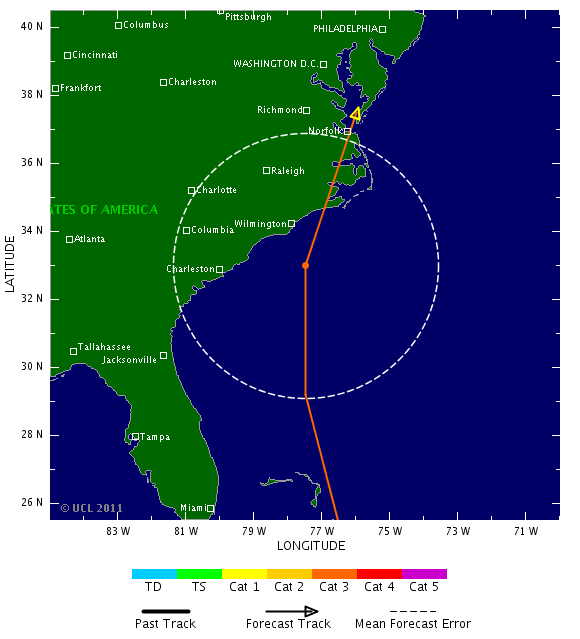
De koers van Irene is weer meer naar het oosten bijgesteld. Het is nog steeds een categorie 2 orkaan en zal de komende dagen over de eilandjes van de Bahama's trekken, waarbij het verder in kracht zal toenemen. Volgens de laatste verwachting gaat het geen categorie 4 worden, maar blijft het bij een categorie 3.
Inmiddels is er een oog zichtbaar.
De laatste run laat hier de orkaan aan land komen.
Inmiddels is er een oog zichtbaar.
De laatste run laat hier de orkaan aan land komen.
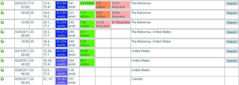
Irene is weer een categorie 2. Gister was de orkaan even in kracht afgenomen naar een cat 1.
Een groter gedeelte van de oostkust zit nu in de gevarenzone.
Een groter gedeelte van de oostkust zit nu in de gevarenzone.


Koers wordt nog altijd oostelijker, komt vermoedelijk ook door het drukgebied boven de grote meren dat oostelijk trekt. NYC lijkt meer en meer in het pad te komen inderdaad. Maar goed, wel kouder water, kan dus nog afzwakken.

quote:Can NYC handle a hurricane?
The National Hurricane Center warns that Hurricane Earl may swing by dangerously close to the U.S. East Coast before curving back out to sea. While the odds are it won't strike New York City directly, such an event is not unprecedented, and the city has plans in place to evacuate — and to hunker down — if need be.
Problem is, there would be precious little time to prepare. And while the forecast suggests it is very unlikely Hurricane Earl will strike Manhattan with more than a glancing blow, a direct hit by a hurricane is ultimately inevitable, scientists say.
Because hurricanes move more quickly and become very difficult to predict once they head north of the Carolinas, experts say there might be just hours to issue evacuation warnings before a storm hits.
Compounding this, the Big Apple has one of highest population densities in the nation – more than 8 million people live in New York City. Based on studies by the Army Corps of Engineers, officials have determined that vulnerable, low-lying areas in and around New York City and metropolitan New Jersey would need to start heading out sooner than what is typically ordered in Florida and other hurricane-prone states.
Frankly put: There would not be enough time to get everyone out. Disaster plans for New York City focus therefore on getting people out of low-lying areas that might be inundated by storm surges, and having others stay put or move to safe locations within the city.
History as a lesson
Since records have been kept in the 1700s, dozens of hurricanes have affected the greater New York City area. A handful were major events. Scientists have geologic evidence that other major hurricanes have hit the region in prehistory.
One event, in 1821, offers a telling lesson. On Sept. 3 that year, a major hurricane slammed without warning into Manhattan. "Everything was flooded south of Canal Street," according to historical accounts. The East River and the Hudson River converged over lower Manhattan, but that part of the island had not yet been built up. The storm hit at low tide. Had the tide been high, the flooding would have been far worse, researchers say.
Late in the summer of 1938 (dit is de FORGOTTEN STORM OF 1938) , a storm that started off the coast of Africa arrived unexpectedly along the coast of New Jersey, where 140 mph (225 kph) winds tore up boardwalks. The storm raced north at more than 50 mph (80 kph) and uprooted trees and destroyed houses on Long Island. Since no warnings were issued, people fled only when they saw the storm approaching, and by the time the storm tore through much of the northeast, an estimated 682 to 800 people were killed, according to "Sudden Sea: The Great Hurricane of 1938" (Back Bay, 2004).
More recently, Hurricane Carol made landfall as a Category 3 storm on Long Island and Connecticut in 1954. In 1960, Hurricane Donna created an 11-foot (3.4 meters) storm surge in New York Harbor, causing extensive pier damage, according to the New York City Office of Emergency Management. Hurricane Gloria in 1985 would have been "catastrophic" if it had hit at high tide and been just slightly closer to the city. There have been several other near-misses in the past six decades.
Scientists note that since so few hurricanes actually strike the New York area, it's hard to say when it will happen again. But history suggests it is only a matter of time before a major hurricane makes a direct hit on Manhattan.
What would happen
The Army Corps has thoroughly mapped what areas could flood. New York Harbor would act like a funnel for an incoming storm surge, and water would have nowhere to go and could be pushed up as high as a 3-story building.
"A major hurricane could push more than 30 feet of storm surge into some parts of New York City," according to the Office of Emergency Management.
The region's major airports are among the locations that could find themselves submerged by the sea. Nursing homes on Coney Island — challenging facilities to evacuate — are at great risk.
New York City has plans in place that, if necessary, would call for evacuations by zones, at the direction of the mayor. [Residents can find their zone here.] The plan focuses on early use of mass transit and discourages evacuation by car. Complicating evacuations is this simple fact: High winds and flooding can precede a major hurricane by hours, bringing a halt to evacuation efforts well before the center of a storm arrives.
Could get worse
Today, with climate change and rising seas levels, the effects of a hurricane could be even worse for New York City, and could become increasingly devastating as time goes on.
A 2001 study conducted by Columbia University scientists looked at several impacts of climate change on the New York metropolitan area. The researchers projected a rise in sea level of 11.8 to 37.5 inches (29.9 to 95.2 centimeters) in New York City and 9.5 to 42.5 inches (24.1 to 107.9 cm) in the metropolitan area by the 2080s.
"With sea level at these higher levels, flooding by major storms would inundate many low-lying neighborhoods and shut down the entire metropolitan transportation system with much greater frequency," said Vivien Gornitz, one of the Columbia University scientists working with the New York City Department of Environmental Protection to better understand what hurricanes would do to the city.
While a hurricane would undoubtedly spell disaster for the city, Manhattan is currently better prepared to face a heavy storm than it has been in previous years, according to Nicholas Coch, a Coastal and Estuarine Geology professor at the City University of New York and an expert on natural disaster preparedness.
"City officials definitely have an improved perception of how to handle a hurricane, especially regarding evacuation plans," Coch told Life's Little Mysteries.
If a hurricane were to hit Manhattan, the island would not necessarily have to be evacuated, said Coch, who reasons that moving people from the lowest areas to higher ground would suffice in keeping them safe – although this should ideally be done the day before the anticipated storm.
In fact, if Earl does come New York's way, it is most likely that beach communities in Suffolk, Long Island, would be hit the hardest, Coch said. Both Suffolk and Nassau county officials say that preparations have been made in case Earl strikes, with updated evacuation plans, potential shelter sites and a new, high-speed notification 'Code RED' system that alerts residents of impending weather emergencies by phone, e-mail and/or text messages.

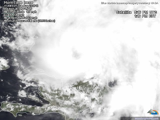
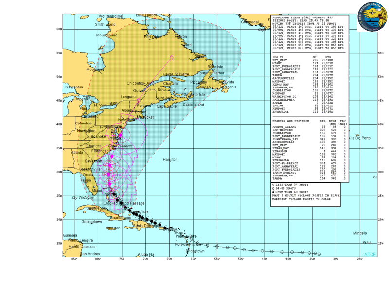
De luchtdruk in de kern van de orkaan Irene is nu 957 mb en geeft aan dat deze nu in een categorie 3 valt. De windsnelheid is opgelopen naar ruim 185 km/uur, waarbij windstoten voorkomen tot 209 km/uur.
Met een snelheid van 14 km/uur trekt Irene nu over de Bahama's.
Met een snelheid van 14 km/uur trekt Irene nu over de Bahama's.

Als dat klopt kunnen ze erg natte voeten gaan krijgen in new york. Ik hoop het voor hun van niet.quote:Op woensdag 24 augustus 2011 11:22 schreef aloa het volgende:
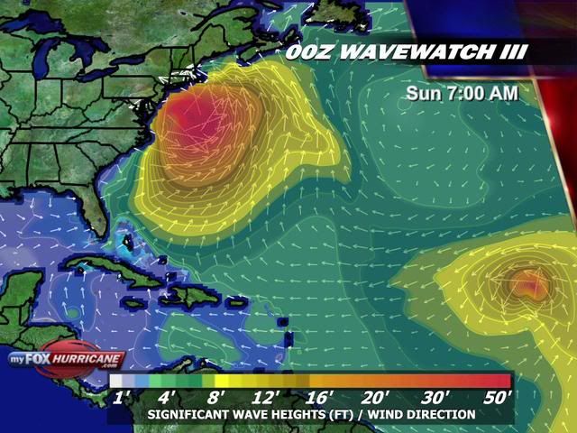
Golfhoogte kan oplopen tot meer dan 12 meter.
[ afbeelding ]
Dat zit er wel erg ongemakkelijk dicht bij in de buurt...quote:
Egregious professor of Cruel and Unusual Geography
Onikaan ni ov dovah
Onikaan ni ov dovah
De eerste mensen worden geëvacueerd van een klein eilandje (Ocracoke Island) voor de kust van North Carolina.
http://www.chicagotribune(...)10824,0,383770.story
http://www.chicagotribune(...)10824,0,383770.story

Spannend dit.
Op zondag 23 maart 2008 02:16 schreef tyros-saver het volgende:
En PaasKonijn Ik heb het gemeld aan de Admin dat jij zei: Heb je typkanker.
En PaasKonijn Ik heb het gemeld aan de Admin dat jij zei: Heb je typkanker.
Goed of slecht ?
Op zondag 5 februari 2012 19:00 schreef Voorschrift het volgende:
Welk sprookjespompoen kom jij uitgestapt?
Welk sprookjespompoen kom jij uitgestapt?
Boston en NYC zijn toch wel dichtbevolkter
Op zondag 5 februari 2012 19:00 schreef Voorschrift het volgende:
Welk sprookjespompoen kom jij uitgestapt?
Welk sprookjespompoen kom jij uitgestapt?
quote:
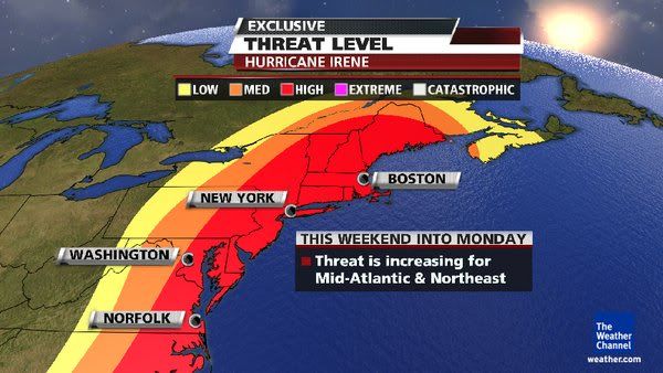
Goed voor Carolina en Virginia, minder goed voor Boston, NYC

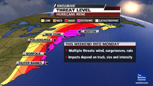
quote:Threat of Irene exposes New York's vulnerability
NEW YORK, Aug 24 (Reuters) - In the annals of natural disasters, it doesn't get much worse than a major hurricane directly striking New York City and Long Island.
Hurricane Irene is on a course that will take it up the East Coast from the weekend. While there is still uncertainty about where it will hit and when, the forecast models increasingly suggest some parts of the greater New York area will face some type of storm or hurricane impact.
According to New York City's Office of Emergency Management, the last hurricane to pass directly over the city was in 1821 -- and it caused tides to rise 13 feet in one hour, flooding all of lower Manhattan to Canal St.
But for Long Island, the threat is much worse. People still talk about the Long Island Express of 1938, a Category 3 storm that the U.S. government has said would cause $40 billion in damage if it hit today.
And what rough beast, its hour come round at last,
Slouches towards Bethlehem to be born?
Slouches towards Bethlehem to be born?
http://www.wunderground.c(...)t.html?entrynum=1898quote:Track Forecast
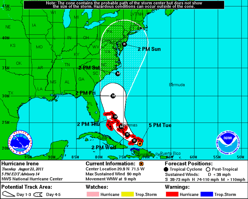
Irene is forecast to move to the northwest, passing over the northwest Bahamas by Thursday evening, then curving to the northeast. Irene then makes landfall in the US near or at the Outer Banks Saturday afternoon, then traveling along the mid-Atlantic coastline of the US. Sunday, Irene may make secondary landfall anywhere from New Jersey to Long Island and the southern New England coastline. In my opinion, New York City may be significantly impacted by Irene. It is also important to note that the windfield of Irene is expected to be large, affecting areas distant from the immediate track of Irene's center. Tropical storm forces winds are expected to be found out to at least 150 miles away from Irene's center on Friday afternoon.
NHC is forecasting for Irene to become a Category 4 storm (winds faster than 130 mph) by Thursday morning. As Irene moves northward into cooler water, the intensity is expected to drop slowly to a Category 2 storm before making landfall in the Outer Banks.
quote:But for Long Island, the threat is much worse. People still talk about the Long Island Express of 1938, a Category 3 storm that the U.S. government has said would cause $40 billion in damage if it hit today.
afwachten of ze nog wat afbuigt of afzwakt

Maar even serieus, als er een categorie 2 of 3 rechtstreeks over new york/manhattan komt, is de schade toch echt enorm?
Laffe huichelaar
Ja.. hopelijk verzwakt de orkaan nog of buigt ie af:quote:Op donderdag 25 augustus 2011 11:36 schreef timmmmm het volgende:
Maar even serieus, als er een categorie 2 of 3 rechtstreeks over new york/manhattan komt, is de schade toch echt enorm?
quote:NEW YORK, Aug 24 (Reuters) - In the annals of natural disasters, it doesn't get much worse than a major hurricane directly striking New York City and Long Island.
And what rough beast, its hour come round at last,
Slouches towards Bethlehem to be born?
Slouches towards Bethlehem to be born?
3 zal het niet worden. Laatste kaartjes en voorspellingen lijken gunstiger te worden. Maar een categorie 2 zal een flinke extra hoeveel water met zich meebrengen qua stormvloed.quote:
Maar even serieus, als er een categorie 2 of 3 rechtstreeks over new york/manhattan komt, is de schade toch echt enorm?
Vraag me af wat ze gaan doen en hoeveel mensen ze gaan evacueren.

Ik vraag me af of er nog webcam's op de Bahama's werken.
http://nl.webcams.travel/(...)rcam-Great-Guana-Cay
http://nl.webcams.travel/(...)rcam-Great-Guana-Cay
Verwachting windsnelheden
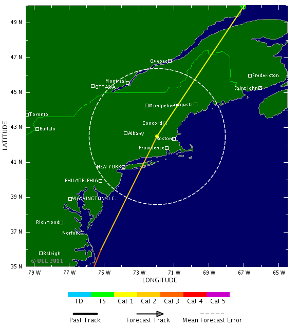
Verwachte pad aldus enkele weermodelen
Europese weermodel laat Irene op NC vallen

Verwachte pad aldus enkele weermodelen

Europese weermodel laat Irene op NC vallen

quote:US Navy fleet leaves Virginia ahead of Irene
NORFOLK, Va. — The U.S. Navy has ordered the Second Fleet in Virginia to leave Norfolk Naval Station to keep the ships safe Hurricane Irene, which is approaching the East Coast.
Thursday's order applies to 64 ships in southeastern Virginia. Twenty-seven ships are moving out to sea, beginning at 8 a.m. An additional 28 are being moved to other places such as repair shipyards that are safer than the piers at Norfolk.
Nine ships are already at sea.
The Navy says ships that are under way can better weather such storms. It also will help protect piers from being damage.
Forecasters have yet to pinpoint where the hurricane will make landfall. It's currently a Category 3 storm with winds of 115 mph.
Die 12 meter is natuurlijk open zee. New York ligt veel meer beschut. Veel interessanter is denk ik de het debiet van de Hudson en de hoogte van de stormvloed.quote:
Als dat klopt kunnen ze erg natte voeten gaan krijgen in new york. Ik hoop het voor hun van niet.
Maar ze hebben in de hudson toch geen stromvloed kering zoals wij die hebben en ze die in london voor de thames gemaakt hebben?quote:
[..]
Die 12 meter is natuurlijk open zee. New York ligt veel meer beschut. Veel interessanter is denk ik de het debiet van de Hudson en de hoogte van de stormvloed.
Alhoewel als ik zo even zoek op internet ligt new york city nog altijd 11 meter boven zee niveau, ik was in de veronderstelling dat het minder hoog was.


New York is niet alleen Manhattan en ligt aan zee.quote:
[..]
Die 12 meter is natuurlijk open zee. New York ligt veel meer beschut. Veel interessanter is denk ik de het debiet van de Hudson en de hoogte van de stormvloed.
North Carolina governor declares state of emergency ahead of Hurricane Irene
http://www.governor.state(...)aspx?newsItemID=1983
http://www.governor.state(...)aspx?newsItemID=1983
quote:New York zet zich schrap voor Irene
NEW YORK - Burgemeester Michael Bloomberg van New York heeft de inwoners van met name lager gelegen stadsdelen opgeroepen zich voor te bereiden op de komst van orkaan Irene. Die hield donderdag nog huis in het Caraïbisch gebied, maar kan volgens meteorologen langs de gehele Amerikaanse oostkust schade en overlast veroorzaken.
Volgens Bloomberg zijn ook de hoogste wolkenkrabbers van New York bestand tegen wind met orkaankracht, maar lopen oudere huizen wel degelijk gevaar. Ook overvloedige regen kan voor problemen zorgen. „Als je een auto hebt en in een laag gelegen buurt woont, parkeer hem dan op een heuvel”, zei de burgemeester. „Zet spullen op de bovenverdieping.”
Irene is een orkaan uit de derde categorie op een schaal van vijf en zal naar verwachting nog iets in kracht toenemen. Het komt niet vaak voor dat zulke krachtige orkanen de omgeving van New York bereiken.