WKN Weer, Klimaat en Natuurrampen
Lees alles over het onstuimige weer op onze planeet, volg orkanen en tornado's, zie hoe vulkanen uitbarsten en hoe Moeder Aarde beeft bij een aardbeving. Alles over de verwoestende kracht van onze planeet en tal van andere natuurverschijnselen.


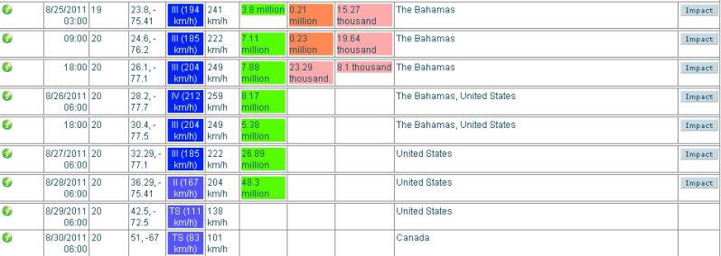
De luchtdruk in de kern van de orkaan Irene is nu 957 mb en geeft aan dat deze nu in een categorie 3 valt. De windsnelheid is opgelopen naar ruim 185 km/uur, waarbij windstoten voorkomen tot 209 km/uur.
Met een snelheid van 14 km/uur trekt Irene nu over de Bahama's.
Met een snelheid van 14 km/uur trekt Irene nu over de Bahama's.


Als dat klopt kunnen ze erg natte voeten gaan krijgen in new york. Ik hoop het voor hun van niet.quote:Op woensdag 24 augustus 2011 11:22 schreef aloa het volgende:
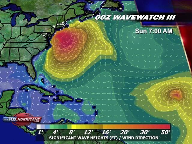
Golfhoogte kan oplopen tot meer dan 12 meter.
[ afbeelding ]
Dat zit er wel erg ongemakkelijk dicht bij in de buurt...quote:
Egregious professor of Cruel and Unusual Geography
Onikaan ni ov dovah
Onikaan ni ov dovah
De eerste mensen worden geëvacueerd van een klein eilandje (Ocracoke Island) voor de kust van North Carolina.
http://www.chicagotribune(...)10824,0,383770.story
http://www.chicagotribune(...)10824,0,383770.story

Spannend dit.
Op zondag 23 maart 2008 02:16 schreef tyros-saver het volgende:
En PaasKonijn Ik heb het gemeld aan de Admin dat jij zei: Heb je typkanker.
En PaasKonijn Ik heb het gemeld aan de Admin dat jij zei: Heb je typkanker.
Goed of slecht ?
Op zondag 5 februari 2012 19:00 schreef Voorschrift het volgende:
Welk sprookjespompoen kom jij uitgestapt?
Welk sprookjespompoen kom jij uitgestapt?
Boston en NYC zijn toch wel dichtbevolkter
Op zondag 5 februari 2012 19:00 schreef Voorschrift het volgende:
Welk sprookjespompoen kom jij uitgestapt?
Welk sprookjespompoen kom jij uitgestapt?
quote:Op woensdag 24 augustus 2011 23:53 schreef Frutsel het volgende:
Goed voor Carolina en Virginia, minder goed voor Boston, NYC

quote:Threat of Irene exposes New York's vulnerability
NEW YORK, Aug 24 (Reuters) - In the annals of natural disasters, it doesn't get much worse than a major hurricane directly striking New York City and Long Island.
Hurricane Irene is on a course that will take it up the East Coast from the weekend. While there is still uncertainty about where it will hit and when, the forecast models increasingly suggest some parts of the greater New York area will face some type of storm or hurricane impact.
According to New York City's Office of Emergency Management, the last hurricane to pass directly over the city was in 1821 -- and it caused tides to rise 13 feet in one hour, flooding all of lower Manhattan to Canal St.
But for Long Island, the threat is much worse. People still talk about the Long Island Express of 1938, a Category 3 storm that the U.S. government has said would cause $40 billion in damage if it hit today.
And what rough beast, its hour come round at last,
Slouches towards Bethlehem to be born?
Slouches towards Bethlehem to be born?
http://www.wunderground.c(...)t.html?entrynum=1898quote:Track Forecast
Irene is forecast to move to the northwest, passing over the northwest Bahamas by Thursday evening, then curving to the northeast. Irene then makes landfall in the US near or at the Outer Banks Saturday afternoon, then traveling along the mid-Atlantic coastline of the US. Sunday, Irene may make secondary landfall anywhere from New Jersey to Long Island and the southern New England coastline. In my opinion, New York City may be significantly impacted by Irene. It is also important to note that the windfield of Irene is expected to be large, affecting areas distant from the immediate track of Irene's center. Tropical storm forces winds are expected to be found out to at least 150 miles away from Irene's center on Friday afternoon.
NHC is forecasting for Irene to become a Category 4 storm (winds faster than 130 mph) by Thursday morning. As Irene moves northward into cooler water, the intensity is expected to drop slowly to a Category 2 storm before making landfall in the Outer Banks.
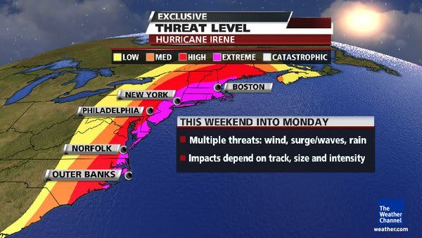
quote:But for Long Island, the threat is much worse. People still talk about the Long Island Express of 1938, a Category 3 storm that the U.S. government has said would cause $40 billion in damage if it hit today.
afwachten of ze nog wat afbuigt of afzwakt

Maar even serieus, als er een categorie 2 of 3 rechtstreeks over new york/manhattan komt, is de schade toch echt enorm?
Laffe huichelaar
Ja.. hopelijk verzwakt de orkaan nog of buigt ie af:quote:Op donderdag 25 augustus 2011 11:36 schreef timmmmm het volgende:
Maar even serieus, als er een categorie 2 of 3 rechtstreeks over new york/manhattan komt, is de schade toch echt enorm?
quote:NEW YORK, Aug 24 (Reuters) - In the annals of natural disasters, it doesn't get much worse than a major hurricane directly striking New York City and Long Island.
And what rough beast, its hour come round at last,
Slouches towards Bethlehem to be born?
Slouches towards Bethlehem to be born?
3 zal het niet worden. Laatste kaartjes en voorspellingen lijken gunstiger te worden. Maar een categorie 2 zal een flinke extra hoeveel water met zich meebrengen qua stormvloed.quote:
Maar even serieus, als er een categorie 2 of 3 rechtstreeks over new york/manhattan komt, is de schade toch echt enorm?
Vraag me af wat ze gaan doen en hoeveel mensen ze gaan evacueren.

Ik vraag me af of er nog webcam's op de Bahama's werken.
http://nl.webcams.travel/(...)rcam-Great-Guana-Cay
http://nl.webcams.travel/(...)rcam-Great-Guana-Cay
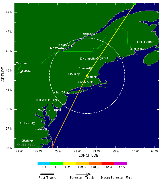
Verwachting windsnelheden
Verwachte pad aldus enkele weermodelen
Europese weermodel laat Irene op NC vallen

Verwachte pad aldus enkele weermodelen

Europese weermodel laat Irene op NC vallen

quote:US Navy fleet leaves Virginia ahead of Irene
NORFOLK, Va. — The U.S. Navy has ordered the Second Fleet in Virginia to leave Norfolk Naval Station to keep the ships safe Hurricane Irene, which is approaching the East Coast.
Thursday's order applies to 64 ships in southeastern Virginia. Twenty-seven ships are moving out to sea, beginning at 8 a.m. An additional 28 are being moved to other places such as repair shipyards that are safer than the piers at Norfolk.
Nine ships are already at sea.
The Navy says ships that are under way can better weather such storms. It also will help protect piers from being damage.
Forecasters have yet to pinpoint where the hurricane will make landfall. It's currently a Category 3 storm with winds of 115 mph.
Die 12 meter is natuurlijk open zee. New York ligt veel meer beschut. Veel interessanter is denk ik de het debiet van de Hudson en de hoogte van de stormvloed.quote:
Als dat klopt kunnen ze erg natte voeten gaan krijgen in new york. Ik hoop het voor hun van niet.