WKN Weer, Klimaat en Natuurrampen
Lees alles over het onstuimige weer op onze planeet, volg orkanen en tornado's, zie hoe vulkanen uitbarsten en hoe Moeder Aarde beeft bij een aardbeving. Alles over de verwoestende kracht van onze planeet en tal van andere natuurverschijnselen.


IRENE op ramkoers V.S.
Momenteel krijgt Puerto Rico de volle laag van orkaan Irene. Het windveld is nu net boven de 120 km/uur, waarbij windstoten voorkomen tot 144 km/uur. De luchtdruk is nu 987 mb. De orkaan trekt met een snelheid van 17 km/uur richting de oostkust van de V.S.
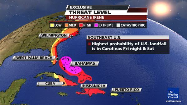
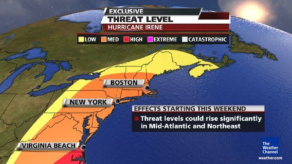
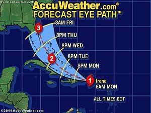
Al enkele dagen laten de weerkaarten dit systeem zien. Het leek erop dat Irene Florida zou treffen en daarna nog in de Golf van mexico tercht zou komen. Nu lijkt het erop dat de koers iets is veranderd en is er een Landfall zichtbaar in de staten Georgia of South Carolina. Waarna de orkaan verder langs de oostkust trekt en ook in steden als New York voor de nodige overlast gaat zorgen.
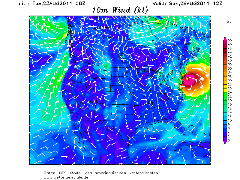
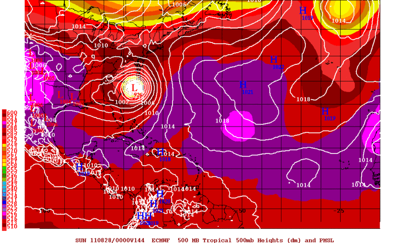
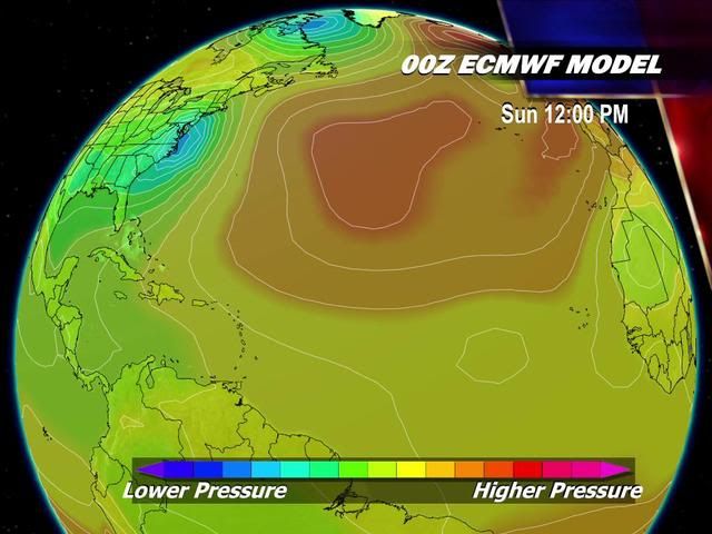
Onderstaande model verwacht een luchtdruk van 926 mb, dit is te vergelijken met een categorie 4 orkaan.
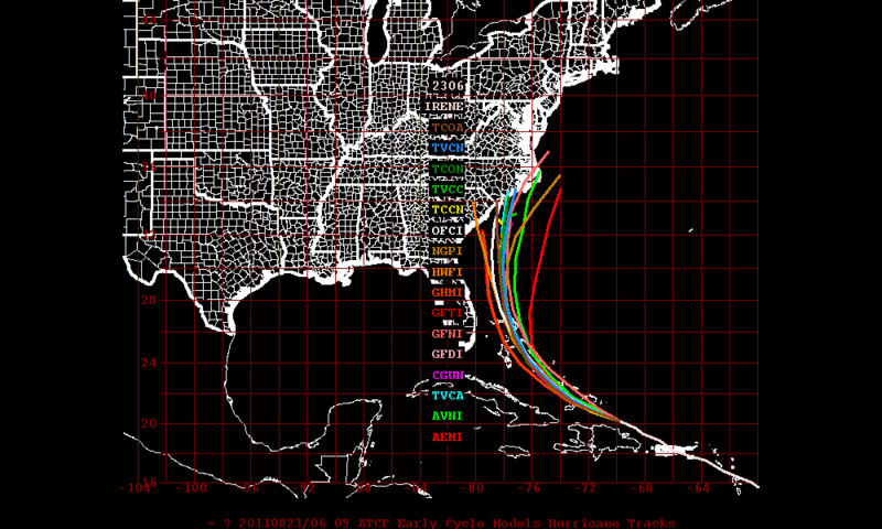
De koers door Tropical Storm Risk
Voor Puerto Rico en de Dominicaanse Republiek is er nu een orkaanwaarschuwing. Voor Haiti is er een waarschuwing voor een tropische storm.
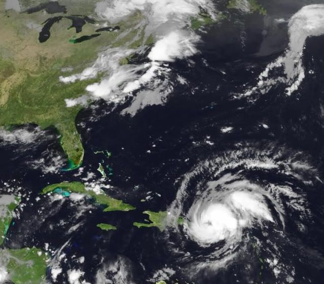
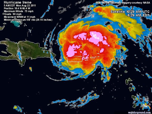
Foto van Irene van maandagochtend 22 augustus
Laatste satellietopnames
Hier kan al het nieuws, vooruitzichten, foto's etc verzameld worden.
Enkele links:
http://www.wunderground.com/tropical/
http://www.tropicalstormrisk.com/
http://tropic.ssec.wisc.edu/#
Zie ook:
Hurricane Season 2011 # 3
[ Bericht 1% gewijzigd door Frutsel op 23-08-2011 13:44:48 ]
Momenteel krijgt Puerto Rico de volle laag van orkaan Irene. Het windveld is nu net boven de 120 km/uur, waarbij windstoten voorkomen tot 144 km/uur. De luchtdruk is nu 987 mb. De orkaan trekt met een snelheid van 17 km/uur richting de oostkust van de V.S.
Al enkele dagen laten de weerkaarten dit systeem zien. Het leek erop dat Irene Florida zou treffen en daarna nog in de Golf van mexico tercht zou komen. Nu lijkt het erop dat de koers iets is veranderd en is er een Landfall zichtbaar in de staten Georgia of South Carolina. Waarna de orkaan verder langs de oostkust trekt en ook in steden als New York voor de nodige overlast gaat zorgen.
Onderstaande model verwacht een luchtdruk van 926 mb, dit is te vergelijken met een categorie 4 orkaan.
De koers door Tropical Storm Risk

Voor Puerto Rico en de Dominicaanse Republiek is er nu een orkaanwaarschuwing. Voor Haiti is er een waarschuwing voor een tropische storm.

Foto van Irene van maandagochtend 22 augustus
Laatste satellietopnames
Hier kan al het nieuws, vooruitzichten, foto's etc verzameld worden.
Enkele links:
http://www.wunderground.com/tropical/
http://www.tropicalstormrisk.com/
http://tropic.ssec.wisc.edu/#
Zie ook:
Hurricane Season 2011 # 3
[ Bericht 1% gewijzigd door Frutsel op 23-08-2011 13:44:48 ]
http://www.cnn.com/2011/W(...)l.weather/index.htmlquote:Tropical Storm Irene hits Puerto Rico
(CNN) -- Tropical Storm Irene made landfall along the east coast of Puerto Rico early Monday, lashing the island with winds up to 71 mph, the National Hurricane Center in Miami reported.
The storm was moving west-northwest at 15 mph (24 kph) and is expected to move near or over the Dominican Republic Monday afternoon or evening, forecasters said. It is expected to weaken as it does.
Rainfall amounts up 5 to 10 inches are expected across Puerto Rico, the Virgin Islands, the Dominican Republic, Haiti, the southeastern Bahamas and the Turks and Caicos Islands, the hurricane center said. Isolated maximum amounts of up to 20 inches are possible.
Hurricane warnings are in effect for Puerto Rico and the Dominican Republic and a hurricane watch is in effect for the central Bahamas and all of the U.S. Virgin Islands.
A tropical storm warning is in effect for the U.S. and British Virgin Islands, Haiti, southeastern Bahamas and the Turks and Caicos Islands.
The Christian aid group World Vision is prepositioning supplies and mobilizing its staff to fan out across camps in Haiti Monday, to help residents prepare for Irene.
"We are concerned that vulnerable families still living in temporary camps won't treat this storm as a serious threat, after Tropical Storm Emily didn't hit Port-au-Prince as predicted," warned World Vision's Meg Sattler in Port-au-Prince. "If flooding hits, people living in unsafe housing will be the worst affected. Heavy rain has the potential to worsen sanitation conditions in camps, which, with cholera still so prevalent in Haiti, is a major concern."
Meanwhile, the storm known as Harvey was near landfall in the southwestern Gulf of Mexcio. The system continued unleashing heavy rainfall early Monday.
At 2 a.m. ET Sunday, Harvey was almost onshore near Veracruz, Mexico, packing top winds of about 35 mph. The storm could dump another two to four inches of rain over southeastern Mexico, with some areas seeing as much as 10 inches, forecasters said.
Harvey struck the coast of Belize Sunday as a tropical storm, with top winds near 60 mph.

Dit topic even in de gaten houden. Bedankt voor de OP 
I Ask for so Little. Just Fear Me, Love Me, Do as I Say, and I Will Be Your Slave.
User van NWS zei: Maak van internet een schoner riool! YES WE CAN!
User van NWS zei: Maak van internet een schoner riool! YES WE CAN!

Dat is zeker een erg krachtige. TSR geeft nu een landfall als categorie 2 aan. (Windsnelheden van 154 tot 177 km/u en een stormvloed van 1,5 tot 2,5 meter boven normaal.)quote:Op maandag 22 augustus 2011 11:44 schreef sonnyspek het volgende:
Is dit een erg krachtige? (srry ik ben een absolute noob in dit soort dingen)
En dan niet vergeten de neerslag wat zo'n systeem met zich meebrengt.
Vol op Florida af....even nakijken op Twitter of mijn contactje daar al wat over zegt.
Optimist tot in de kist
Miniem's internetvriendinnetje :P
Bij vlagen briljant, helaas is het momenteel windstil
Miniem's internetvriendinnetje :P
Bij vlagen briljant, helaas is het momenteel windstil
Inmiddels een orkaan dus?
Cat.2 landfall op dit moment, maar hij kan zeker nog groeien. Genoeg potentie
En de oostkust? Ai... dat kan hele vervelende gevolg gaan hebben
Cat.2 landfall op dit moment, maar hij kan zeker nog groeien. Genoeg potentie
En de oostkust? Ai... dat kan hele vervelende gevolg gaan hebben
quote:Caribisch gebied zet zich schrap voor storm Irene
SAN JUAN - Eilanden in het Caribisch gebied zetten zich schrap voor de komst van de orkaan
Irene, de tropische storm die maandag tot een orkaan uitgroeide, heeft op verschillende plaatsen al voor harde windstoten en veel regenval gezorgd. Eerder werden op de Amerikaanse Maagdeneilanden bomen uit de grond gerukt en viel de stroom op veel plaatsen uit.
Na Puerto Rico aangedaan te hebben, trekt Irene vermoedelijk verder richting Hispaniola, het eiland dat de Dominicaanse Republiek deelt met Haïti. In Haïti zijn nog altijd zeshonderdduizend mensen dakloos na de aardbeving van vorig jaar.
In de Puerto Ricaanse hoofdstad San Juan zochten mensen zondag een veilig heenkomen in afwachting van Irene, die vermoedelijk voor zo'n 25 centimeter neerval zal zorgen. Er worden windstoten tot 120 kilometer per uur verwacht.
Eiland af
Op het vliegveld van Puerto Rico probeerden veel mensen nog van het eiland af te komen, maar veel vluchten waren al geannuleerd.
De autoriteiten van de Dominicaanse Republiek hebben verzekerd genoeg voedsel te hebben voor 1,5 miljoen mensen, mocht daaraan behoefte zijn.
Bewoners van risicogebieden zijn inmiddels door militairen en reddingswerkers geëvacueerd. "We hebben alle voorzorgsmaatregelen getroffen", zei woordvoerder Rafael Nuñez.
Later in de week zal Irene richting de Amerikaanse oostkust trekken en vermoedelijk Florida, Georgia en North- en South-Carolina aandoen. Irene is de eerste orkaan van het Atlantische orkaanseizoen.
De eerste orkaan van dit seizoen en meteen richting de oostkust, hoe bestaat het.quote:
Inmiddels een orkaan dus?
Cat.2 landfall op dit moment, maar hij kan zeker nog groeien. Genoeg potentie
En de oostkust? Ai... dat kan hele vervelende gevolg gaan hebben
Nu is de plek landfall wel belangrijk... en zeker hoelang Irene stand houdt, want een Cat.1 op sommige plekken aan de oostkust kan hele grote problemen gevenquote:Op maandag 22 augustus 2011 12:29 schreef aloa het volgende:
[..]
De eerste orkaan van dit seizoen en meteen richting de oostkust, hoe bestaat het.
Volgens mij lijkt Hispanolia er goed vanaf te komen, minder goed nieuws voor de oostkust. Genoeg potentie om zeker een Cat.3 te halen.
Doet me denken aan EARL
edit:ah..gevonden
Hurricane EARL richting Oostkust V.S.
Irene lijkt zeker een direct hit te worden. Earl draaide nog weg
edit:ah..gevonden
Hurricane EARL richting Oostkust V.S.
Irene lijkt zeker een direct hit te worden. Earl draaide nog weg
Hoppa, irene gaat heel de VS opzuigen ;-)
Inorbit: zeg dat dan typluie triangeljosti
Beauregard: Een beetje FOK!ker laat het brood door z'n moeder smeren.
Ecosia
ek's 'n flash drive, jy's 'n floppy
Beauregard: Een beetje FOK!ker laat het brood door z'n moeder smeren.
Ecosia
ek's 'n flash drive, jy's 'n floppy

En wij moeten vrijdag vanuit Orlando vliegen, gelukkig ligt dat wat landinwaards, maar toch
04-08-11, 02-02-12, 20-06-14, 13-08-15
Vrijdag ligt ze precies voor de kust van Florida.quote:
En wij moeten vrijdag vanuit Orlando vliegen, gelukkig ligt dat wat landinwaards, maar toch
Ze zullen er wel met een grote boog omheen vliegen.
quote:Puerto Rico cleans up after Hurricane Irene
SAN JUAN, Puerto Rico (AP) — Puerto Rico's governor is urging people to stay home as the island begins cleaning up from Hurricane Irene.
Gov. Luis Fortuno says the storm has closed more than a dozen roads, knocked down many trees and caused at least two landslides. More than 800,000 households have been without power. That's about half the island. The governor told reporters Monday that the storm caused no deaths or major injuries.
Schools and many businesses in the U.S. island territory are closed as crews assessed the damage. The governor says people should avoid going out because of the danger posed by fallen live power lines and other hazards. He says he doesn't yet know when power will be restored.


Cat.3 landfall zou zo maar kunnen... Windshear is er te verwaarlozen en genoeg warm water om uit te groeien, zeker als ze Hispanolia mist.
Er zijn verwachtingen dat hij toch iets meer oostelijk zal gaan.. dan zouden de Carolina's meer in de gevarenzone liggen. Veel zal afhangen van wat ze verliest aan kracht op de Dom.Rep en hoe de curve dan zal lopen.
Of we krijgen alsnog een EARL scenario
Of we krijgen alsnog een EARL scenario
Lijkt me wel. Heel veel schade mogelijk.quote:
CAT 3 aan de oostkust is toch redelijk gevaarlijk?
quote:Hurricane Irene strengthened into the season's first Atlantic hurricane at 5am EDT this morning as the eye moved over San Juan, Puerto Rico, and crossed into the ocean just north of the island. Overnight, Irene held its own as the eye passed over the most mountainous portion of Puerto Rico, the El Yunque region. Winds in the higher mountains likely reached Category 2 strength, 96 - 110 mph, according to measurements from the San Juan Terminal Doppler Radar, and the hurricane pounded the island with damaging winds and flooding rains, resulting in widespread tree damage and power failures that hit 800,000 people. The San Juan Airport recorded top winds of 41 mph, gusting to 55 mph, and 2.87" of rain, as of 9am AST. Tropical storm conditions affected the Virgin Islands, with St. Thomas recording sustained winds of 40 mph, gusting to 67 mph, and 4.03" of rain as of 6am AST today. At 7am EDT, the ship Horizon Trader measured sustained northeast winds of 69 mph and wave heights of 11.5 feet at 19°N, in the northern eyewall of Irene. Latest observations from an Air Force hurricane hunter aircraft indicate that Irene is slowly intensifying, with a central pressure of 989 mb observed at 9:42am EDT. The eyewall is not fully formed yet, with a gap on the south side. This gap will need to close off before the hurricane can undergo rapid intensification.
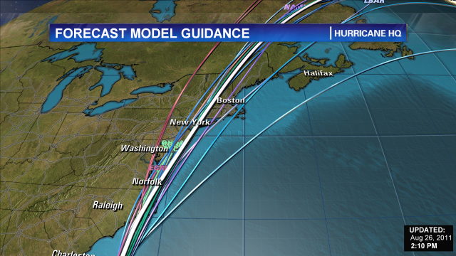
Track forecast for Irene
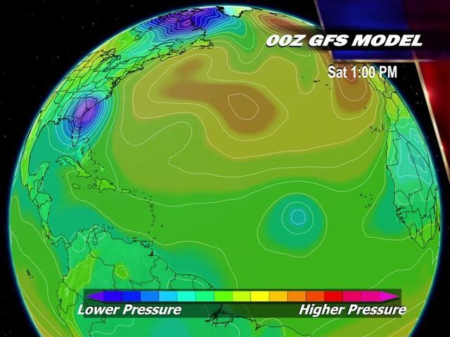
The computer models show good agreement that Irene will pass along the north coast of Hispaniola today, but just a slight wobble in Irene's track to take it farther offshore--or push it onshore, over the mountains--will have major impacts on the ultimate path and strength of the hurricane. A trough of low pressure is expected to move across the Eastern U.S. on Wednesday and Thursday, turning Irene more to the northwest by Wednesday. The timing and strength of this trough varies considerably from model to model, and will be critical in determining where and when Irene will turn to the north. Irene's strength will also matter--a stronger Irene is more likely to turn northward earlier. The most popular solution among the models is to take Irene to the northwest through the Bahamas on Wednesday and Thursday, then into the Southeast U.S. coast in South Carolina or North Carolina on Saturday. Irene would then travel up the mid-Atlantic coast, arriving near Long Island, New York on Monday morning as a strong tropical storm or Category 1 hurricane. One of the models proposing this solution is our best model, the ECMWF. However, we have two other of our very good models suggesting a landfall near Miami on Thursday night is likely (the GFDL and UKMET models.) NHC forecaster Stacy Stewart gave some good reasons in this morning's discussion to favor a track close to the east coast of Florida, but just offshore. Last years' worst performing major the model, the NOGAPS, predicts that Irene will pass out to sea, missing the Southeast U.S. coast. Keep in mind that the average error of a 4-day forecast from NHC is 200 miles, and just a small deviation in the path of a storm moving roughly parallel to the coast will make a huge difference in where it ultimately makes landfall. The NOAA jet will be flying its first dropsonde mission into Irene today, which should result in a more reliable set of model runs first thing Tuesday morning.
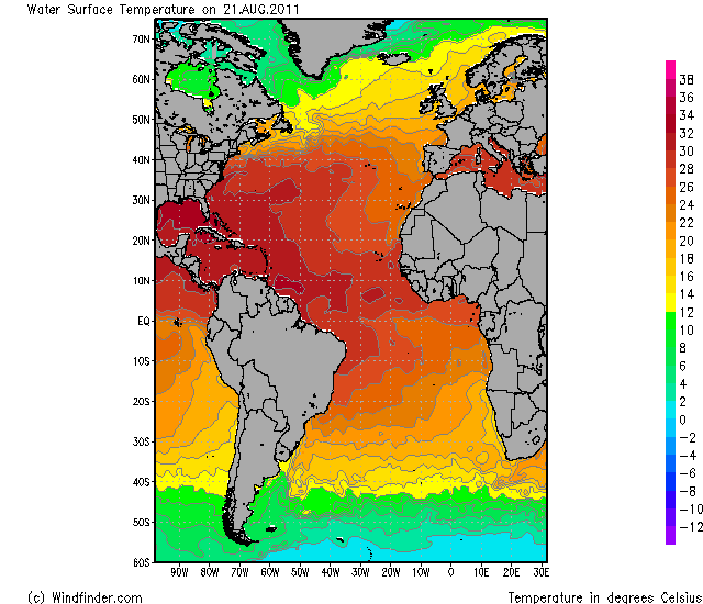
Intensity forecast for Irene
Irene is embedded in a large envelope of moisture now, and wind shear is expected to remain low, 5 - 10 knots, for the next five days. With water temperatures very warm, 29 - 30°C, these conditions should allow for intensification except when land is interfering. Satellite loops show that Irene is steadily growing in size, which will protect the storm against major disruption by its passage along the north shore of Hispaniola today. The storm is lacking much development on its southwest side, where dry air is interfering with development. This dry air may help keep southern portions of the Dominican Republic and Haiti from receiving more than 3 - 6 inches of rain. There is at least a 30% chance that passage of the eye over Hispaniola will reduce Irene to a tropical storm tonight and into Tuesday. Due to Hispaniola blocking inflow of moist air from the south, Irene will likely compensate by building an even larger region of heavy thunderstorms to the north, offshore. Thus, when Irene's center finally moves well away from the coast on Tuesday, it will be a bigger storm, with the potential to spread hurricane conditions over a wider area later in the week when it intensifies. One limiting factor for intensification may be in the upper-level outflow pattern. The hurricane is lifting a huge amount of air from the surface to the upper atmosphere, and all that mass has to be efficiently transported away in order for the hurricane to intensify. Right now, upper level outflow is only well-established to the north and east, and the forecast outflow pattern for the coming five days is only moderately favorable. Overall, I think the official NHC forecast of a Category 3 hurricane by Thursday is the right one, though Irene could easily be a Category 2 or Category 4 storm.
Irene's impact on the Dominican Republic
Heavy rains from Irene have already reached the eastern tip of the Dominican Republic, where Punta Cana has seen wind gusts up to 29 mph this morning. The northeast coast of the country near Samana will receive the worst of Irene's wrath, with sustained winds of 50 - 70 mph and gusts above hurricane force likely to cause widespread tree damage and power outages today. Passage along the coast of the island may weaken Irene to a tropical storm by Tuesday morning, and wind damage in Puerto Plata may be less severe than at Samana. The capital of Santo Domingo will see lesser winds, perhaps 30 - 50 mph, with gusts to 60 mph. The main danger to the Dominican Republic will be Irene's torrential rains, which are likely to reach 20 inches in some mountainous regions, causing dangerous flash floods and mudslides.
Dr. Jeff Masters
[ Bericht 0% gewijzigd door #ANONIEM op 22-08-2011 18:42:07 ]
EARL boog al veel eerder af (nog voor Puerto Rico). Ik denk dat de kans dat deze landfall gaat maken veel groter is, dan bij EARL. 100% zekerheid heb je niet, maar de kans is groot.quote:
Er zijn verwachtingen dat hij toch iets meer oostelijk zal gaan.. dan zouden de Carolina's meer in de gevarenzone liggen. Veel zal afhangen van wat ze verliest aan kracht op de Dom.Rep en hoe de curve dan zal lopen.
Of we krijgen alsnog een EARL scenario

de laatste was meen ik Emilyquote:
CAT 3 aan de oostkust is toch redelijk gevaarlijk?
Een cat.1 in NY geeft pas grote problemen
Google maar eens op "The forgotten hurricane from 1938" ofzoiets


Orkaan Irene wordt snel sterker
NAGUA - De eerste orkaan van het Atlantische orkaanseizoen, Irene, heeft voor zware windstoten en veel regen gezorgd.
Gevreesd wordt dat Irene dinsdag uitgroeit tot een orkaan van de derde categorie en mogelijk binnen 72 uur zelfs tot een van de vierde categorie. Dat stelt het Amerikaanse orkaancentrum in Miami.
"We hadden er niet op gerekend dat Irene zo snel zo sterk zou worden", zei Chris Landsea, als meteoroloog verbonden aan het centrum.
Mogelijk is Irene nog altijd zo sterk als ze later deze week de oostkust van de Verenigde Staten bereikt en in Florida, Georgia of South-Carolina aan land komt. Maandag deed ze Puerto Rico aan, waar bomen ontworteld werden en meer dan een miljoen mensen zonder stroom kwamen te zitten. Er zijn geen gewonden gemeld.
Ook in de Dominicaanse Republiek zorgde de orkaan voor problemen. Meer dan duizend Dominicanen zijn geëvacueerd. Er wordt niet verwacht dat Irene buurland Haïti zal aandoen, hoewel het land waarschijnlijk wel met zware regenval te maken krijgt. In Haïti zijn nog altijd zeshonderdduizend mensen dakloos na de aardbeving van vorig jaar.
nu.nl
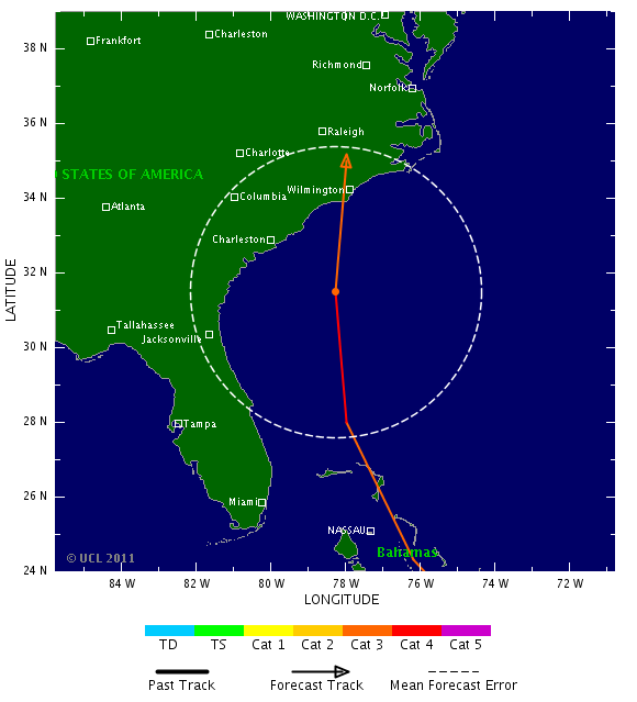
Ze wijkt toch wel degelijk af nu. Florida wordt gemist, Zuid en Noord Carolina worden doelwit.
Categorie 3 landfall
Categorie 3 landfall

Let wel: Iets meer naar het oosten en Manhattan krijgt een direct hitquote:
Ze trekt steeds meer naar het oosten inderdaad. Koers veranderd elke keer weer.
Irene ligt nu ten noorden van de Dominicaanse Republiek. De luchtdruk is gedaald tot 978 mb. Met een maximaal windveld van 160 km/uur en windstoten tot 193 km/uur valt de orkaan nu in een Categorie 2.
Met een snelheid van 17 km/uur trekt Irene richting de Bahama's. Onderweg zal ze nog in kracht toenemen tot een categorie 3 en waarschijnlijk ook nog een categorie 4.
Wat er na de Bahama's gaat gebeuren is nog niet geheel duidelijk. De koers veranderd steeds meer naar het oosten. Waarschijnlijk zal er een landfall plaatsvinden in zuid of noord Carolina en zal de orkaan daarna verder noordwaarts trekken in de richting van New York.
GFS laat nu zoiets zien...quote:
[..]
Let wel: Iets meer naar het oosten en Manhattan krijgt een direct hit